When Tragedy Strikes: Potential Contributions From Ocean Observation to Search and Rescue Operations After Drowning Accidents
 Marcos Mateus
 Ricardo Canelas1
  Ligia Pinto
 Nuno Vaz
- 1MARETEC – Marine, Environment and Technology Centre, Instituto Superior Técnico, LARSyS, Universidade de Lisboa, Lisbon, Portugal
- 2CESAM, Departamento de Física, Universidade de Aveiro, Aveiro, Portugal
Drowning accidents followed by the disappearance of the body are particularly distressing events. When such tragedy strikes, Search and Rescue Operations are usually deployed to recover the body. The efficiency of such efforts can be enhanced by timely data and appropriate data integration tools, such as operational prediction systems relying on numerical models or other data sources. In this paper, we propose four stages for Search and Rescue Operations after drowning accidents and briefly address the critical role of ocean observations at each stage, as well as the relevancy of available computational resources. The potential of the combination of different data sources on the state of the sea to provide better insights is discussed. This work encourages oceanographers, data scientists and relevant marine stakeholders to produce knowledge and tools to support Search and Rescue Operations after drowning accidents.
Introduction
Drowning accidents followed by the disappearance of the body are tragedies with a disruptive impact on society. The unknown location of the missing person is particularly distressing and recovering the body is culturally seen as an indisputable necessity by most societies. A full commitment from the authorities coordinating Search and Rescue Operations (onward referred to as SAR) is expected so that the missing body can be reclaimed. From an empiric perspective, this commitment is frequently inefficient. Once a body disappears at sea, it is either lost or eventually found after resurfacing (Duijst et al., 2016), which can take place in a period ranging from a few days up to several months (Giertsen and Morild, 1989; Mateus et al., 2013; Mateus and Vieira, 2014; Mateus and Pinto, 2016). Standard SAR protocols are characterized by intense search efforts during the first few days, frequently followed by regular, less intensive, scouting from land, sea or air over the following days (Stoop, 2003). Until now, the employment of ocean observations in this context has mostly been tentative (Pampìn and Rodrìguez, 2001; Carniel et al., 2002; Breivik and Allen, 2008; Ellingham et al., 2017), relying on available technologies and computational resources that were mostly developed for other purposes.
This paper proposes the division of SAR for drowning accidents in the coastal ocean into four distinct stages: first response, watchful stand-by, active search and disengaged waiting. Available resources, data or otherwise, for each stage are briefly addressed, followed by a discussion on some of their limitations and potential inputs. This contribution is primarily a call to the involvement of the ocean observation community to tackle new ways of providing valuable assistance to the complex and demanding SAR after drowning accidents. Our goal is to encourage ocean scientists to collaborate with the forensic scientists to better support SAR efficiency in locating and recovering bodies in the water.
The Four Stages of Drowning Search
The fate of a body after drowning depends on numerous parameters, both site- and victim-specific (Stoop, 2003; Papadodima et al., 2010). Each drowning accident is unique and has different outcomes, even when victims are physiologically similar (e.g., the same age, size, and gender) and have drowned simultaneously and at the same spot (Mateus and Vieira, 2014). However, the post-drowning processes that control the decomposition of the body are known and allow to predict the basic patterns of the body vertical and horizontal displacement (Mateus et al., 2013). Based on empirical evidence, we propose four distinct stages for the post-drowning period (Figure 1), each characterized by rather different interactions between the body and its surroundings. Consequently, each stage requires different approaches and commitment from the authorities coordinating SAR, as well as distinct contributions from the ocean data community. The four stages are briefly described in this section.
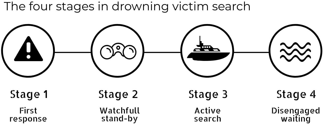
Figure 1. The classification of the four stages of drowning search is made based on the role of the many processes involved in the fate of the body after drowning, as well as on the adequate response from SAR.
Stage 1: First Response
First Response is the immediate SAR after a drowning accident followed by a missing victim. On-location emergency search operations usually consist of visual inspection, i.e., scouting the waters from the shore by the maritime authorities, people at the site, lifeguards (if present), etc. Additional efforts, such as aerial surveys or exploration by boat are also commonly used at this stage. If the body is not found and retrieved during the first few hours of daylight search, submersion is highly probable and, scouting the water becomes unproductive. This stage usually extends for 1–2 days.
Stage 2: Watchful Stand-by
Stage 2 starts with the assumption that the body has sunk and will remain so until buoyancy is regained. This stage also assumes that a fatality has occurred, i.e., there is unequivocal evidence that the person has drowned. The duration of this stage depends on several factors, both physiological (size, mass, and gender of the missing person) and environmental (current velocity, bathymetric features, water depth, temperature, and density). The use of any flotation device by the victim is also of relevance and must to be considered.
Water temperature is the most relevant parameter for the duration of this stage, as it controls the decomposition rate of the body. This process will determine the time needed for the accumulation of putrefactive gas that will induce buoyancy, a period named post-mortem submersion interval (PMSI) (Lunetta et al., 2014; Mateus et al., 2015). During this period the body will be at the bottom, where horizontal displacement is reduced by roughness and other bed features (rocks, debris, snags, etc.). The hydrodynamics of the site will determine if gravitational and frictional forces overcome drag forces by the current, in which case the horizontal displacement of the body is significantly reduced. Depending on the water temperature, the PMSI can range from a few days, up to a few weeks (Giertsen and Morild, 1989; Mateus et al., 2013; Mateus and Vieira, 2014). In this stage, authorities in charge of the SAR should allow time to pass without significant intervention. The effort of closely watching the water must be continued, not necessarily with the same intensity has in Stage 1.
Stage 3: Active Search
If dislodged from rocks, caves, branches, etc., the body will eventually regain buoyancy and resurface, ending the PMSI, becoming visible. The timing of this event can be estimated by SAR units, based on the calculation of accumulated degree days (ADD) (Megyesi et al., 2005; Mateus et al., 2013; Mateus and Vieira, 2014; Mateus and Pinto, 2016). An active search must then be resumed, but in a significantly larger radius than in Stage 1, aiming to spot the body as soon as possible after resurfacing, thus preventing significant drift due to waves or stronger surface currents. At this stage, horizontal displacement is important, as the body can be transported significant distances away from the drowning area in a relatively short period. As an example, reports show that bodies can travel several kilometers in just a few days (Dilen, 1984; Pampìn and Rodrìguez, 2001), although beach stranding is also common (Mateus et al., 2013; Mateus and Vieira, 2014). The fate of the body will ultimately depend on the hydrodynamic characteristics of the site, coastline morphology, presence of natural features such as estuaries or river mouths, etc. Setting a duration for this stage is not recommendable, as it depends on many factors: the hydrodynamics of the area, available SAR resources, public demands or legal investigation requirements.
Stage 4: Disengaged Waiting
Unsuccessful results in SAR during Stage 3 mean one of three things: the body is either (1) trapped at the bottom by natural features or weight that prevents resurfacing (clothes, heavy objects, stones, etc.), (2) is at a depth that makes bloating inefficient to provide buoyancy, or (3) has resurfaced and transported by currents away from the searching area. As the chances of finding the body by active search at this stage are dim, waiting in a passive stance is the only option, since prolonging the search operations will be futile. This is, nonetheless, a waiting stage. As in many cases, the body may eventually appear, sometimes weeks later and at significant distances from the place of drowning (Giertsen and Morild, 1989; Pampìn and Rodrìguez, 2001).
Potential Contributions From the Ocean Observation Community
This section explores how ocean observation, in its many disciplines, can enhance the efficacy of SAR after drowning accidents. We address some intrinsic limitations of available resources and suggest potential improvements. For simplicity, the stages are discussed separately, as their characteristics require distinct approaches and tools.
Stage 1: Guiding Immediate Actions
Existing Resources
Body reclamation is the main goal after a confirmed drowning accident. When a body is missing, SAR requires real-time data on the hydrodynamic patterns at the site of the accident, wind direction, wave regime, and on relevant natural features, such as protruding rocks, caves, etc. Such data usually come from distinct sources and may have different spatial and temporal resolutions. However, in situ data is often expensive and difficult to get. Moreover, the available ocean observational, modeling and forecasting systems provide products that are often found inadequate for coastal regions (De Mey and Proctor, 2009; Ardhuin et al., 2019; O’Callaghan et al., 2019). A way to go around such limitation in data acquisition relies on the use of global databases such as Copernicus1, CORDEX2, or the GODAE Ocean View3, which can provide relevant data for SAR, namely on the state of atmospheric and ocean (coastal) conditions and respective forecasts. Real-time access may also be available for ocean predictive systems of surface level and current velocity (e.g., ocean circulation), wave buoys (significant wave height and peak period data), weather stations (wind intensity and direction data), high frequency (HF) radar systems that measure the speed and direction of ocean surface currents in near real-time, as well as topo-bathymetric information, such as multibeam bathymetric mosaics4.
Meteorological and ocean predictive systems are, in fact, a source of relevant data to SAR, which can be combined with available in situ or database data, and are frequently used at this stage (Ebbesmeyer and Haglund, 1994; Breivik and Allen, 2008). Meteorological models, for instance, provide information on atmospheric conditions (e.g., wind intensity and direction, air temperature and precipitation), allowing better planning of SAR. Besides, meteorological forecast models provide the necessary boundary condition to force ocean models (e.g., wind intensity and direction, responsible by surface currents and the generation of waves) that can be used at a later stage in SAR (see section “Stage 3: Pointing Directions”).
Nowadays there are several available ocean models, covering a wide range of complexity in the modeled processes. The output of such models provides realistic information on the tridimensional physical structure of the ocean, from velocity fields to temperature, both crucial in SAR. Some of these models are central tools in operational systems that provide useful forecast data regarding oceanographic conditions (Banas and Hickey, 2005; Mateus et al., 2012; Giddings et al., 2014; Vaz et al., 2015, 2018; Ardhuin et al., 2019). Besides, such models allow for the use of tracers modeling (Lagrangian Elements – LE), to simulate the movement of submerged and/or emerged particles. LE can be moved around in three dimensions (x, y, and z) according to local current fields from a previously computed hydrodynamic solution. Recent examples of the use of Lagrangian models to compute the pathways of passive surface drifters are found in the literature (e.g., Banas et al., 2009; Kjellsson and Döös, 2012; Kjellsson et al., 2013; Mateus et al., 2015; Pinto et al., 2016), and a full review of the use of Lagrangian methods in the ocean can be found in van Sebille et al. (2018).
The use of LE is particularly useful at this stage, as it allows to calculate the position of particles in the marine system and predicted future trajectory as a function of ocean currents, wind and waves (depending on the complexity of the model). This enables tracking the potential path of a body, by performing several simulations based on the actual state of the ocean (Carniel et al., 2002; Breivik and Allen, 2008).
Limitations
The amount of information available to support SAR, along with the complexity of relating different variables, can become limitative by the lack of a proper format, and tools to acquire and process it (De Mey and Proctor, 2009). LE models coupled to hydrodynamic models usually perform the simulations under the assumption of a floating particle, with no (or limited) vertical movement, thus compromising the relevance of such simulations. So far, only a few application have used variable immersion levels for LE (e.g., Breivik et al., 2012a). Despite this general approximation, the implementation of such models can reduce the search area, by narrowing on the most probable area where the drowned body can be found. Studies on drowning accidents reveal that the bodies only stay at the surface when strapped to flotation devices, or in cases of death by other reasons other than drowning (e.g., heart failure, for instance). In drowning accidents, the victim ingests water, thus changing its specific gravity, leading to sinking. Higher order considerations on the processes affecting the floatability of a body can be incorporated on LE models, but data is scarce, and variability is high, rendering limited use to most LE models.
Potential Developments
Even if all the relevant information is available in real-time, processing such information can be impractical, so it is imperative to integrate it in a useful way. Such task can be performed by designed algorithms, able to access data from the diverse sources and use it to estimate the probability of transport or retention of the body along the coast, according to relevant parameters (Figure 2). Several methods are available nowadays to compute coastal variability of hydrodynamic processes (e.g., current velocity) and other water properties such as natural tracers like salinity and water temperature, but also to track the position and movements of LE. These methods, based on unsupervised neural networks, are currently used in oceanographic studies of system variability (Liu et al., 2009; Vaz et al., 2018).
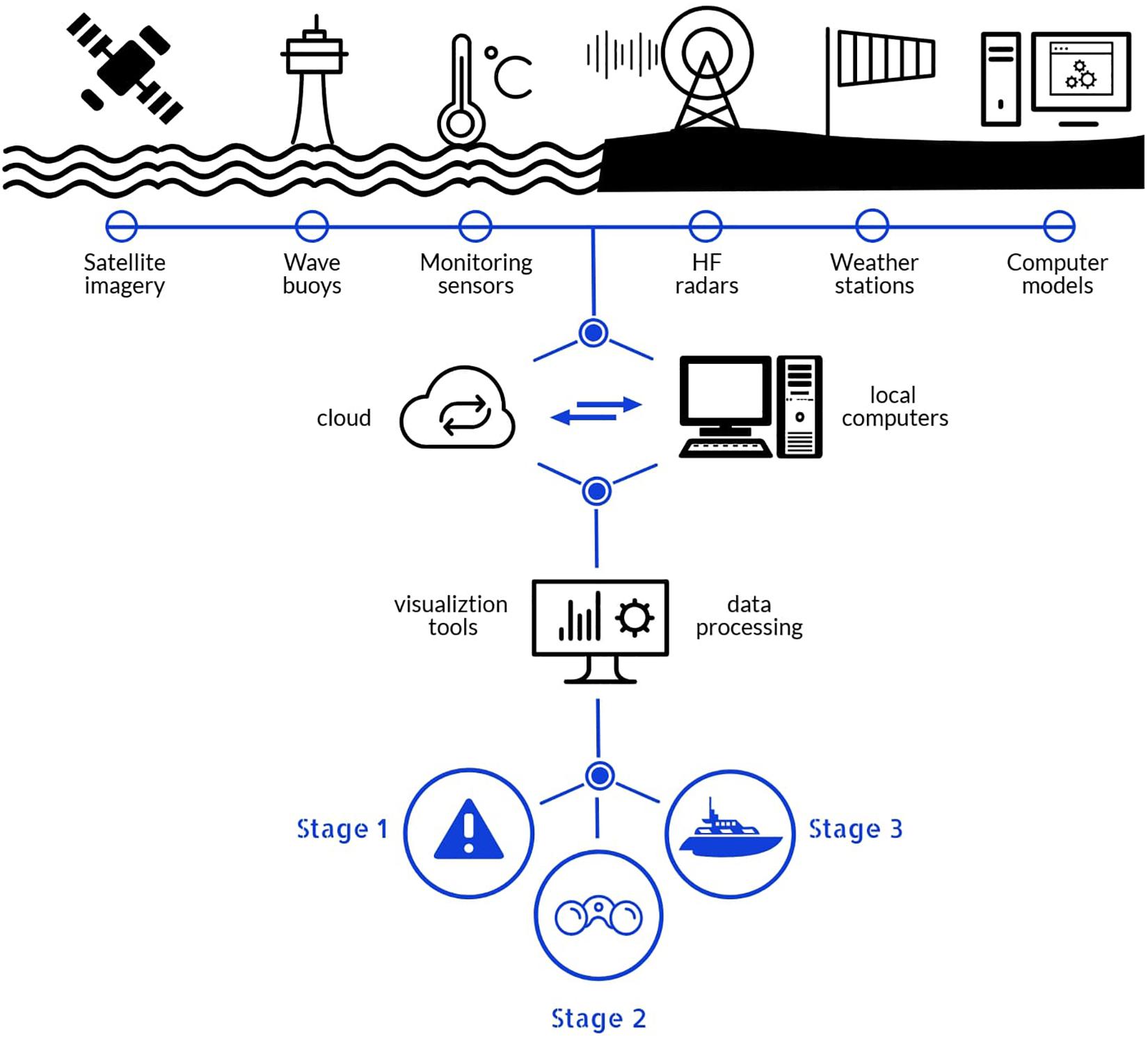
Figure 2. Information flow from the many sources of data and information derived from ocean observations, down to its use during the several stages of SAR.
Processed information must then become available, for instance through a dashboard using a GIS display of a probability map to guide SAR in finding the body (Figure 3). Despite their obvious limitations at this stage, LE algorithms hold much promise, as new developments are being made to confer independent behavior to the particles, such as vertical movements as pre-defined processes or in response to environmental conditions.
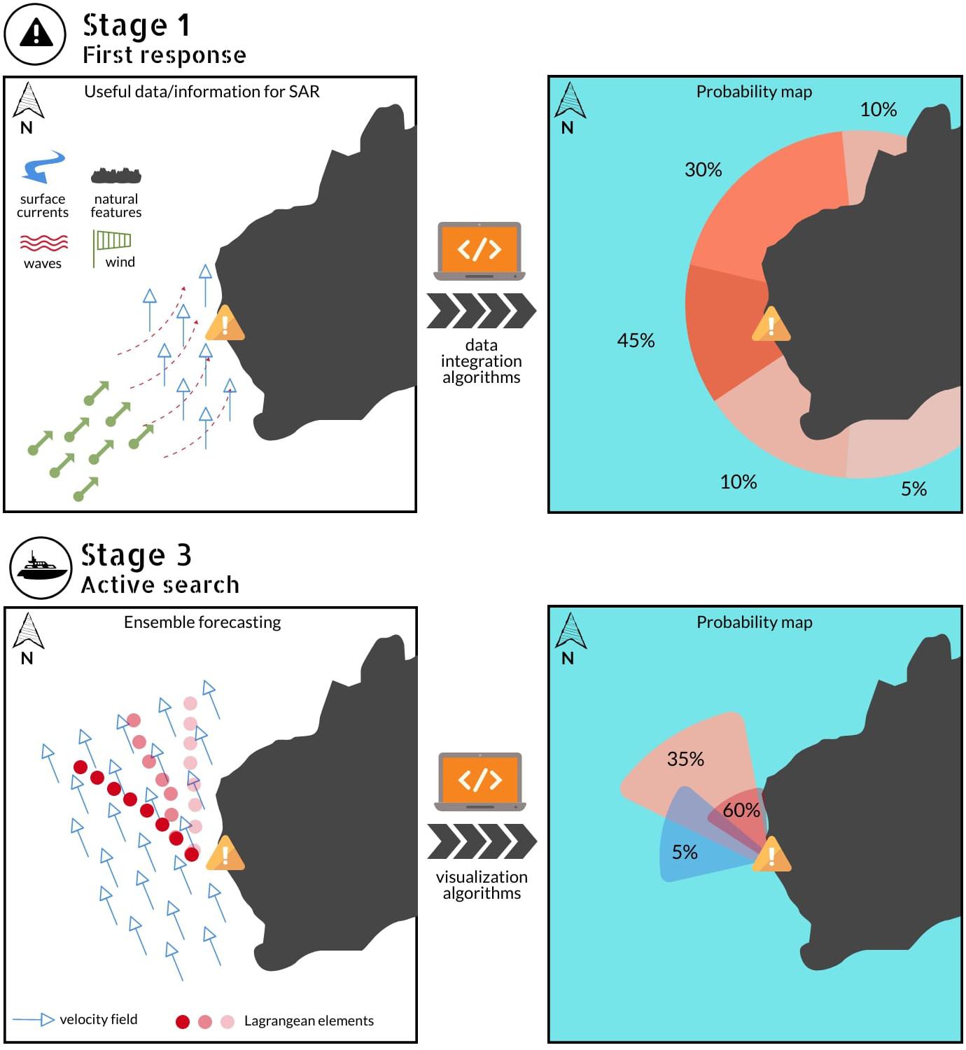
Figure 3. Stage 1: Illustration of an accident site (marked in yellow) and its surrounding physical features (left), and a schematics of a potential probability map that can be determined by integrating available information and data (right). Stage 3: Illustration of multiple model results for LE using ensemble forecasting (left), and schematics of a potential probability map that can be calculated from those results (right).
Stage 2: Duration of the Stand-by
Existing Resources
SAR scenarios related to drowning and missing victims are characterized by a significant amount of uncertainties. However, drowned bodies undergo known thermodynamic processes making it possible to predict the PMSI (Papadodima et al., 2010; Mateus and Vieira, 2014), by calculating the necessary ADD for a human corpse to resurface from sea surface temperature (Mateus et al., 2013, 2015). Ocean temperature data to calculate ADD can be retrieved from in situ sensors such as wave buoys (if available), remote sensing data (satellite imagery) and from ocean models integrated into operational ocean prediction systems. Models have the advantage of providing forecasts for the ocean temperature, thus enabling to identify in advance the occurrence of the threshold for expected gaining in the flotation of the body. The use of LE models is not uncommon during this period as a support in the search efforts, mostly to identify the most probable areas to find the body, based on the simulated circulation patterns (in hindcast, nowcast, and forecast modes).
Limitations
At this stage, it is usually assumed that the body is at the seabed, so any attempts at modeling drift at the surface are unsuitable (Mateus et al., 2015). PMSI ends with the regaining of buoyancy in a process regulated by the fundamental laws of physics. The decomposition process is the most relevant, as it induces bloating, resulting in the resurfacing of drowned victims (Donoghue and Minnigerode, 1977; Dilen, 1984; Heaton et al., 2010). The physical process underlying this occurrence is the change in the specific gravity, the relationship between the density of the body and surrounding water density, that decreases as gases are produced during decomposition (Mann et al., 1990; Mateus et al., 2013). For this reason, most studies assume that water temperature determines the duration of the PMSI, avoiding the additional complexity of tackling the influence of other factors. However, additional data is needed to support or improve on this inference, considering other factors that determine the specific gravity of a corpse, such as the victim’s age (a proxy to intrinsic characteristics such as body height, weight, and tissue composition) (Donoghue and Minnigerode, 1977), site depth (Reisdorf et al., 2012) or the presence or absence of clothes at the moment of drowning (Introna et al., 2013).
Potential Developments
Other factors besides water temperature may influence the PMS. However, data on them are difficult to attain, especially when the media are frequently the only available source of information in drowning accidents. In this respect, data mining algorithms can play a decisive role, by searching continuously for available information on the cloud. Data processing should also be performed by the employment of traditional statistical techniques and other methods capable of accounting for data variability, as neural networks that allow system variability, computing the percentage of occurrence of a specific coastal pattern (like different current velocity and direction). However, more sophisticated approaches can yield better insights, such as big data analytics (Tsai et al., 2015), to gather and analyze data from multiple levels, including site descriptions, victims’ parameters such as age, gender, PMSI, water temperature during the PMSI, body displacement, since they can compute the actual state of a variable and allow to predict its behavior. Big data analytics has been proved useful to examine large amounts of data and uncover hidden patterns, correlations and other insights in many other fields (Herland et al., 2014; Najafabadi et al., 2015; Kumar and Toshniwal, 2016) and may as well help to identify key factors associated with body flotation after drowning, allowing more reliable prediction based on specific meteo-oceanographic variables.
During Stage 2, data on weather and ocean conditions, ADD evolution calculated based on water temperature, and PMSI should be continuously updated and available to SAR, either by mobile devices or in the form of an intuitive dashboard. Alerts can then be issued when the ADD goes above a given threshold. Using operational platforms, computer models can predict weather and oceanographic conditions in advance, up to 3 days with high confidence. This information can be used to calculate ADD in advance and predict a possible resurfacing threshold.
Stage 3: Pointing Directions
Existing Resources
Stage 3 starts when the body resurfaces and becomes under the influence of more dynamic conditions. This means that it can be transported alongshore or offshore by strong currents, or even pushed onshore by wave action. As such, ocean observations and hydrodynamic models provide crucial information at this stage. Operational ocean predictive systems, for instance, can provide nowcasts and forecasts of ocean circulation and temperature and their results used to compute estuarine and coastal variability (Mateus et al., 2012; Vaz et al., 2015, 2018; Ardhuin et al., 2019), but their results are seldom used in SAR. Also, over the past few years, online systems such as the MARPOCS Platform5 were created for on-demand simulations with real-time forcing conditions, allowing to track the movement of particles like containers, drifting boats, debris, etc. Such products can be used to simulate possible drift pathways of the body at this stage.
Limitations
While having wider spatial and temporal coverage than observations, most ocean prediction systems relying on modeling on models are either academic applications or tools tailored for specific tasks, such as port operations or coastal management (González et al., 2008; Perivoliotis et al., 2011; De Mey et al., 2017). These models can provide pertinent information on body drift, such as the most probable direction, but the margins of uncertainty pose a serious limitation for an efficient search over vast areas of the ocean.
Potential Developments
Ensemble forecasting can be used once the estimated ADD hits a given threshold, and the analyzed parameters suggest a potential resurfacing of the body. Instead of performing single forecast for the most likely trajectory (one origin and a specific group of environmental conditions), this methodology can produce a set (or ensemble) of forecasts that will provide an estimative of the range of possible conditions and, consequently, trajectories (Milliff et al., 2011; Pinardi et al., 2011; Melsom et al., 2012; Scott et al., 2012; Golbeck et al., 2015; van Sebille et al., 2018). Probability sectors can be defined from such simulations, narrowing down the search areas to more efficient management of the scarce, frequently expensive, human and logistic resources involved in SAR, such as the use of boats, vessels, helicopters, and planes. As in Stage 1, the results should be delivered in an intuitive form, possibly displaying the most probable areas to find the body (Figure 3).
Stage 4: Finding the Origin
Existing Resources
Stage 4 is a waiting period of undetermined duration, only ending if the body is found. Usually, this is a fortuitous event, as most bodies under such circumstances are frequently unrecovered or found far from the accident site. Coastal hydrodynamic data like current velocity is the only relevant information from ocean observation systems at this stage, providing insights on the areas of the ocean or coastal stretches where the body may eventually be found. However, existing data and computational resources may provide pertinent assistance to SAR, not to recover a body after a drowning accident, but to track the point of entry when a body is found (with unknown origin and cause of death). Such information can be achieved by using inverse drift computation, relying on knowing current velocity fields, obtained from ocean models or by high-resolution currents measured by coastal HF radar networks (Abascal et al., 2012). Such backtracking methods have mostly been used for oil dispersion studies (Breivik et al., 2012b; Suneel et al., 2016; Chen, 2019), but also as forensic support in the tragic accident of Air France flight (AF447) over the Atlantic (Drévillon et al., 2013).
Limitations
Several uncertainties in drift properties and environmental forcing (wind, surface currents, and waves) compromise the task of determining the origin of any drifting object (Breivik et al., 2012b). Changes in the state of the body imposed by decaying and marine fauna activity add complexity to this task. Such non-linear state variations represent a drawback to the apparently simple process of running a stochastic or deterministic trajectory model in reverse. Also, one of the obvious limitations of using backtracking methods relies on the identification of the time of the accident, so that the outcome of model simulation may be interpreted correctly. Such information comes from taphonomic studies of the found remains (Mann et al., 1990; Heaton et al., 2010; Simmons et al., 2010; Introna et al., 2013), meaning that a close collaboration between the ocean and forensic scientists is required.
Potential Developments
The existing backtracking methods, e.g., available ocean data service providers and ocean forecasting systems, deliver a useful starting point to assist SAR at Stage 4. Inverse drift computation, however, can be improved by the combination of available sources of data such as HF radar currents and atmospheric models, as proposed by Abascal et al. (2012), or ocean gliders (Testor et al., 2019). The combination of probabilistic and statistical models also deserves serious attention to address the non-linear nature of the processes controlling the drift of the bodies. The indispensable development, however, consists of a system that enables SAR authorities to have timely access to both backtracking simulations results and criminal records and databases of missing persons, such as the NamUs database (National Missing and Unidentified Persons System)6.
Author Contributions
MM led the design and development of the manuscript. NV contributed to the development of the manuscript and provided feedback focused on the Perspective. RC and LP contributed to the development of the manuscript and provided feedbacks throughout its many stages of preparation.
Funding
The work of MM, RC, and LP, as well as the publication fees, were supported by FCT/MCTES (PIDDAC) through project UIDB/EEA/50009/2020. NV was funded by national funds (OE), through FCT – Fundação para a Ciência e a Tecnologia, IP, in the scope of the framework contract foreseen in the numbers 4, 5, and 6 of the article 23, of the Decree-Law 57/2016, of August 29, changed by Law 57/2017, of July 19. Additional support from CESAM (UID/AMB/50017 – POCI-01-0145-FEDER-007638), FCT/MCTES through national funds (PIDDAC), and the co-funding by the FEDER, within the PT2020 Partnership Agreement and Compete 2020.
Conflict of Interest
The authors declare that the research was conducted in the absence of any commercial or financial relationships that could be construed as a potential conflict of interest.
Footnotes
- ^ https://www.copernicus.eu/en/myocean
- ^ https://www.medcordex.eu/medcordex.php
- ^ https://www.godae-oceanview.org/
- ^ https://maps.ngdc.noaa.gov/viewers/bathymetry/
- ^ http://marpocs.actionmodulers.com/
- ^ https://www.namus.gov/
References
Abascal, A. J., Castanedo, S., Fernández, V., and Medina, R. (2012). Backtracking drifting objects using surface currents from high-frequency (HF) radar technology. Ocean Dyn. 62, 1073–1089. doi: 10.1007/s10236-012-0546-4
Ardhuin, F., Stopa, J. E., Chapron, B., Collard, F., Husson, R., Jensen, R. E., et al. (2019). Observing Sea States. Front. Mar. Sci. 6:124. doi: 10.3389/fmars.2019.00124
Banas, N. S., and Hickey, B. M. (2005). Mapping exchange and residence time in a model of Willapa Bay, Washington, a branching, macrotidal estuary. J. Geophys. Res. Ocean 110:C11011. doi: 10.1029/2005JC002950
Banas, N. S., MacCready, P., and Hickey, B. M. (2009). The columbia river plume as cross-shelf exporter and along-coast barrier. Cont. Shelf Res. 29, 292–301. doi: 10.1016/j.csr.2008.03.011
Breivik, Ø, and Allen, A. A. (2008). An operational search and rescue model for the Norwegian Sea and the North Sea. J. Mar. Syst. 69, 99–113. doi: 10.1016/j.jmarsys.2007.02.010
Breivik, Ø, Allen, A. A., Maisondieu, C., Roth, J. C., and Forest, B. (2012a). The leeway of shipping containers at different immersion levels. Ocean Dyn. 62, 741–752. doi: 10.1007/s10236-012-0522-z
Breivik, Ø, Bekkvik, T. C., Wettre, C., and Ommundsen, A. (2012b). BAKTRAK: backtracking drifting objects using an iterative algorithm with a forward trajectory model. Ocean Dyn. 62, 239–252. doi: 10.1007/s10236-011-0496-2
Carniel, S., Umgiesser, G., Sclavo, M., Kantha, L. H., and Monti, S. (2002). Tracking the drift of a human body in the coastal ocean using numerical prediction models of the oceanic, atmospheric and wave conditions. Sci. Justice 42, 143–151. doi: 10.1016/S1355-0306(02)71819-4
Chen, H. (2019). Performance of a simple backtracking method for marine oil source searching in a 3D ocean. Mar. Pollut. Bull. 142, 321–334. doi: 10.1016/j.marpolbul.2019.03.045
De Mey, P., and Proctor, R. (2009). Assessing the value of GODAE products in coastal and shelf seas?: LLLiverpool, 10-11 October 2007. Ocean Dyn. 59, 1–2. doi: 10.1007/s10236-008-0175-0
De Mey, P., Stanev, E., and Kourafalou, V. H. (2017). Science in support of coastal ocean forecasting—part 1. Ocean Dyn. 67, 665–668. doi: 10.1007/s10236-017-1048-1
Dilen, D. R. (1984). The motion of floating and submerged objects in the chattahoochee river, Atlanta, GA. J. Forensic Sci. 29, 1027–1037.
Donoghue, E. R., and Minnigerode, S. C. (1977). Human body buoyancy: a study of 98 men. J. Forensic Sci. 22, 573–579.
Drévillon, M., Greiner, E., Paradis, D., Payan, C., Lellouche, J.-M., Reffray, G., et al. (2013). A strategy for producing refined currents in the Equatorial Atlantic in the context of the search of the AF447 wreckage. Ocean Dyn. 63, 63–82. doi: 10.1007/s10236-012-0580-2
Duijst, W., Passier, C., Oude Grotebevelsborg, B., de Kat, D., van Daalen, M., and Oostra, R. J. (2016). Lost and found: the identification process of human bodies recovered from the North Sea. J. Forensic Leg. Med. 41, 15–20. doi: 10.1016/j.jflm.2016.04.006
Ebbesmeyer, C., and Haglund, W. D. (1994). Drift trajectories of a floating human body simulated in a hydraulic model of Puget Sound. J. Forensic Sci. 39, 231–240.
Ellingham, S. T. D., Perich, P., and Tidball-Binz, M. (2017). The fate of human remains in a maritime context and feasibility for forensic humanitarian action to assist in their recovery and identification. Forensic Sci. Int. 279, 229–234. doi: 10.1016/j.forsciint.2017.07.039
Giddings, S. N., MacCready, P., Hickey, B. M., Banas, N. S., Davis, K. A., Siedlecki, S. A., et al. (2014). Hindcasts of potential harmful algal bloom transport pathways on the Pacific Northwest coast. J. Geophys. Res. Ocean. 119, 2439–2461. doi: 10.1002/2013JC009622
Giertsen, J. C., and Morild, I. (1989). Seafaring bodies. Am. J. Forensic Med. Pathol. 10, 25–27. doi: 10.1097/00000433-198903000-00007
Golbeck, I., Li, X., Janssen, F., Brüning, T., Nielsen, J. W., Huess, V., et al. (2015). Uncertainty estimation for operational ocean forecast products—a multi-model ensemble for the North Sea and the Baltic Sea. Ocean Dyn. 65, 1603–1631. doi: 10.1007/s10236-015-0897-8
González, M., Ferrer, L., Uriarte, A., Urtizberea, A., and Caballero, A. (2008). Operational oceanography system applied to the Prestige oil-spillage event. J. Mar. Syst. 72, 178–188. doi: 10.1016/j.jmarsys.2007.07.005
Heaton, V., Lagden, A., Moffatt, C., and Simmons, T. (2010). Predicting the postmortem submersion interval for human remains recovered from U.K. Waterways∗. J. Forensic Sci. 55, 302–307. doi: 10.1111/j.1556-4029.2009.01291.x
Herland, M., Khoshgoftaar, T. M., and Wald, R. (2014). A review of data mining using big data in health informatics. J. Big Data 1:2. doi: 10.1186/2196-1115-1-2
Introna, F., Di Vella, G., and Campobasso, C. P. (2013). Migrant deaths and the Kater Radez I wreck: from recovery of the relict to marine taphonomic findings and identification of the victims. Int. J. Legal Med. 127, 871–879. doi: 10.1007/s00414-012-0807-2
Kjellsson, J., and Döös, K. (2012). Surface drifters and model trajectories in the Baltic Sea. Boreal Environ. Res. 6, 447–459.
Kjellsson, J., Döös, K., and Soomere, T. (2013). “Evaluation and tuning of model trajectories and spreading rates in the baltic sea using surface drifter observations,” in BT - Preventive Methods for Coastal Protection: Towards the Use of Ocean Dynamics for Pollution Control, eds T. Soomere and E. Quak, (Heidelberg: Springer International Publishing), 251–281. doi: 10.1007/978-3-319-00440-2_8
Kumar, S., and Toshniwal, D. (2016). A novel framework to analyze road accident time series data. J. Big Data 3, 8. doi: 10.1186/s40537-016-0044-5
Liu, Y., MacCready, P., and Hickey, B. M. (2009). Columbia river plume patterns in summer 2004 as revealed by a hindcast coastal ocean circulation model. Geophys. Res. Lett 36:L02601. doi: 10.1029/2008GL036447
Lunetta, P., Ebbesmeyer, C., and Molenaar, J. (2014). “Behaviour of dead bodies in water,” in in BT - Drowning: Prevention, Rescue, Treatment, ed. J. J. L. M. Bierens, (Berlin: Springer Berlin Heidelberg), 1149–1152. doi: 10.1007/978-3-642-04253-9_179
Mann, R. W., Bass, W. M., and Meadows, L. (1990). Time since death and decomposition of the human body: variables and observations in case and experimental field studies. J. Forensic Sci. 35, 103–111.
Mateus, M., de Pablo, H., and Vaz, N. (2013). An investigation on body displacement after two drowning accidents. Forensic Sci. Int 229, e6–e12. doi: 10.1016/j.forsciint.2013.03.010
Mateus, M., and Pinto, L. (2016). Report on the accumulated degree days and post mortem submersion interval for an infant drowning accident. J Forensic Investig. 4:3.
Mateus, M., Pinto, L., and Chambel-Leitão, P. (2015). Evaluating the predictive skills of ocean circulation models in tracking the drift of a human body: a case study. Aust. J. Forensic Sci. 47, 322–331. doi: 10.1080/00450618.2014.957346
Mateus, M., Riflet, G., Chambel, P., Fernandes, L., Fernandes, R., Juliano, M., et al. (2012). An operational model for the West Iberian coast: Products and services. Ocean Sci. 8, 713–732. doi: 10.5194/os-8-713-2012
Mateus, M., and Vieira, V. (2014). Study on the postmortem submersion interval and accumulated degree days for a multiple drowning accident. Forensic Sci. Int. 238, e15–e19. doi: 10.1016/j.forsciint.2014.02.026
Megyesi, M. S., Nawrocki, S. P., and Haskell, N. H. (2005). Using accumulated degree-days to estimate the postmortem interval from decomposed human remains. J. Forensic Sci. 50, 1–9. doi: 10.1520/jfs2004017
Melsom, A., Counillon, F., LaCasce, J. H., and Bertino, L. (2012). Forecasting search areas using ensemble ocean circulation modeling. Ocean Dyn. 62, 1245–1257. doi: 10.1007/s10236-012-0561-5
Milliff, R. F., Bonazzi, A., Wikle, C. K., Pinardi, N., and Berliner, L. M. (2011). Ocean ensemble forecasting. Part I: ensemble mediterranean winds from a bayesian hierarchical model. Q. J. R. Meteorol. Soc. 137, 858–878. doi: 10.1002/qj.767
Najafabadi, M. M., Villanustre, F., Khoshgoftaar, T. M., Seliya, N., Wald, R., and Muharemagic, E. (2015). Deep learning applications and challenges in big data analytics. J. Big Data 2:1. doi: 10.1186/s40537-014-0007-7
O’Callaghan, J., Stevens, C., Roughan, M., Cornelisen, C., Sutton, P., Garrett, S., et al. (2019). Developing an integrated ocean observing system for New Zealand. Front. Mar. Sci. 6:143. doi: 10.3389/fmars.2019.00143
Pampìn, J. B., and Rodrìguez, B. A. (2001). Surprising drifting of bodies along the coast of Portugal and Spain. Leg. Med 3, 177–182. doi: 10.1016/S1344-6223(01)00032-3
Papadodima, S. A., Athanaselis, S. A., Skliros, E., and Spiliopoulou, C. A. (2010). Forensic investigation of submersion deaths. Int. J. Clin. Pract. 64, 75–83. doi: 10.1111/j.1742-1241.2008.01890.x
Perivoliotis, L., Krokos, G., Nittis, K., and Korres, G. (2011). The Aegean sea marine security decision support system. Ocean Sci. 7, 671–683. doi: 10.5194/os-7-671-2011
Pinardi, N., Bonazzi, A., Dobricic, S., Milliff, R. F., Wikle, C. K., and Berliner, L. M. (2011). Ocean ensemble forecasting. Part II: mediterranean forecast system response. Q. J. R. Meteorol. Soc. 137, 879–893. doi: 10.1002/qj.816
Pinto, L., Mateus, M., and Silva, A. (2016). Modeling the transport pathways of harmful algal blooms in the Iberian coast. Harmful Algae 53, 8–16. doi: 10.1016/j.hal.2015.12.001
Reisdorf, A. G., Bux, R., Wyler, D., Benecke, M., Klug, C., Maisch, M. W., et al. (2012). Float, explode or sink: postmortem fate of lung-breathing marine vertebrates. Palaeobiodivers. Palaeoenviron. 92, 67–81. doi: 10.1007/s12549-011-0067-z
Scott, R. B., Ferry, N., Drévillon, M., Barron, C. N., Jourdain, N. C., Lellouche, J. M., et al. (2012). Estimates of surface drifter trajectories in the equatorial Atlantic: a multi-model ensemble approach. Ocean Dyn. 62, 1091–1109. doi: 10.1007/s10236-012-0548-2
Simmons, T., Adlam, R. E., and Moffatt, C. (2010). Debugging decomposition data—comparative taphonomic studies and the influence of insects and carcass size on decomposition rate. J. Forensic Sci. 55, 8–13. doi: 10.1111/j.1556-4029.2009.01206.x
Stoop, J. A. (2003). Maritime accident investigation methodologies. Inj. Control Saf. Promot. 10, 237–242. doi: 10.1076/icsp.10.4.237.16776
Suneel, V., Ciappa, A., and Vethamony, P. (2016). Backtrack modeling to locate the origin of tar balls depositing along the west coast of India. Sci. Total Environ. 569–570, 31–39. doi: 10.1016/j.scitotenv.2016.06.101
Testor, P., DeYoung, B., Rudnick, D. L., Glenn, S., Hayes, D., Lee, C., et al. (2019). OceanGliders: A component of the integrated GOOS. Front. Mar. Sci 6:422. doi: 10.3389/fmars.2019.00422
Tsai, C.-W., Lai, C.-F., Chao, H.-C., and Vasilakos, A. V. (2015). Big data analytics: a survey. J. Big Data 2, 21. doi: 10.1186/s40537-015-0030-3
van Sebille, E., Griffies, S. M., Abernathey, R., Adams, T. P., Berloff, P., Biastoch, A., et al. (2018). Lagrangian ocean analysis: fundamentals and practices. Ocean Model. 121, 49–75. doi: 10.1016/j.ocemod.2017.11.008
Vaz, N., Mateus, M., Plecha, S., Sousa, M. C., Leitão, P. C., Neves, R., et al. (2015). Modeling SST and chlorophyll patterns in a coupled estuary-coastal system of Portugal: the tagus case study. J. Mar. Syst. 147, 123–137. doi: 10.1016/j.jmarsys.2014.05.022
Keywords: Search and Rescue Operations, ocean observations, ocean models, forensic oceanography, drowning accidents
Citation: Mateus M, Canelas R, Pinto L and Vaz N (2020) When Tragedy Strikes: Potential Contributions From Ocean Observation to Search and Rescue Operations After Drowning Accidents. Front. Mar. Sci. 7:55. doi: 10.3389/fmars.2020.00055
Received: 11 September 2019; Accepted: 27 January 2020;
Published: 12 February 2020.
Edited by:
Johannes Karstensen, GEOMAR Helmholtz Centre for Ocean Research Kiel, GermanyReviewed by:
Fraser J. Davidson, Fisheries and Oceans Canada, CanadaEric Jansen, Ca’ Foscari University of Venice, Italy
Copyright © 2020 Mateus, Canelas, Pinto and Vaz. This is an open-access article distributed under the terms of the Creative Commons Attribution License (CC BY). The use, distribution or reproduction in other forums is permitted, provided the original author(s) and the copyright owner(s) are credited and that the original publication in this journal is cited, in accordance with accepted academic practice. No use, distribution or reproduction is permitted which does not comply with these terms.
*Correspondence: Marcos Mateus, marcos.mateus@tecnico.ulisboa.pt