Innovations in Coastline Management With Natural and Nature-Based Features (NNBF): Lessons Learned From Three Case Studies
 Cindy M. Palinkas1*
  Philip Orton2
  Michelle A. Hummel3
  William Nardin1
  Ariana E. Sutton-Grier4
  Lora Harris5
  Matthew Gray1
  Ming Li1 Donna Ball6,7 Kelly Burks-Copes8
  Meri Davlasheridze9
  Matthieu De Schipper10 Douglas A. George11 Dave Halsing7
  Coraggio Maglio8 Joseph Marrone12 S. Kyle McKay13 Heidi Nutters14 Katherine Orff15 Marcel Taal16
  Alexander P. E. Van Oudenhoven17 William Veatch18 Tony Williams19
- 1Horn Point Laboratory, University of Maryland Center for Environmental Science, Cambridge, MD, United States
- 2Stevens Institute of Technology, Hoboken, NJ, United States
- 3Department of Civil Engineeering, University of Texas at Arlington, Arlington, TX, United States
- 4Earth System Science Interdisciplinary Center, University of Maryland, College Park, College Park, MD, United States
- 5Chesapeake Biological Laboratory, University of Maryland Center for Environmental Science, Solomons, MD, United States
- 6San Francisco Estuary Institute, Richmond, CA, United States
- 7South Bay Salt Pond Restoration Project, San Francisco, CA, United States
- 8US Army Corps of Engineers, Galveston, TX, United States
- 9Texas A&M University atGalveston, Galveston, TX, United States
- 10Delft University of Technology, Delft, Netherlands
- 11National Oceanic and Atmospheric Administration (NOAA), San Francisco, CA, United States
- 12Arcadis, Long Island City, NY, United States
- 13US Army Engineer Research and Development Center, Vicksburg, MS, United States
- 14San Francisco Estuary Partnership, San Francisco, CA, United States
- 15Graduate School of Architecture, Planning, and Preservation, Columbia University, New York, NY, United States
- 16Deltares, Delft, Netherlands
- 17Institute of Environmental Sciences CML, Leiden University, Leiden, Netherlands
- 18US Army Corps of Engineers, New Orleans, LA, United States
- 19Texas General Land Office, Austin, TX, United States
Coastal communities around the world are facing increased coastal flooding and shoreline erosion from factors such as sea-level rise and unsustainable development practices. Coastal engineers and managers often rely on gray infrastructure such as seawalls, levees and breakwaters, but are increasingly seeking to incorporate more sustainable natural and nature-based features (NNBF). While coastal restoration projects have been happening for decades, NNBF projects go above and beyond coastal restoration. They seek to provide communities with coastal protection from storms, erosion, and/or flooding while also providing some of the other natural benefits that restored habitats provide. Yet there remain many unknowns about how to design and implement these projects. This study examines three innovative coastal resilience projects that use NNBF approaches to improve coastal community resilience to flooding while providing a host of other benefits: 1) Living Breakwaters in New York Harbor; 2) the Coastal Texas Protection and Restoration Study; and 3) the South Bay Salt Pond Restoration Project in San Francisco Bay. We synthesize findings from these case studies to report areas of progress and illustrate remaining challenges. All three case studies began with innovative project funding and framing that enabled expansion beyond a sole focus on flood risk reduction to include multiple functions and benefits. Each project involved stakeholder engagement and incorporated feedback into the design process. In the Texas case study this dramatically shifted one part of the project design from a more traditional, gray approach to a more natural hybrid solution. We also identified common challenges related to permitting and funding, which often arise as a consequence of uncertainties in performance and long-term sustainability for diverse NNBF approaches. The Living Breakwaters project is helping to address these uncertainties by using detailed computational and physical modeling and a variety of experimental morphologies to help facilitate learning while monitoring future performance. This paper informs and improves future sustainable coastal resilience projects by learning from these past innovations, highlighting the need for integrated and robust monitoring plans for projects after implementation, and emphasizing the critical role of stakeholder engagement.
1 Introduction
There is a growing need to protect shorelines from coastal flooding due to accelerating numbers of floods due to sea-level rise (Sweet et al., 2018) and a rapid increase in billion-dollar coastal storm disasters (NRC 2014; Smith 2020). Sea-level rise in particular is predicted to have much larger impacts to coastal communities during the remainder of this century and into the future (IPCC 2021). Traditional approaches to coastal protection largely have relied on “gray” infrastructure, such as seawalls, levees, and breakwaters, which may reduce the risk of flooding but may have adverse ecological impacts (Bilkovic and Mitchell 2013) and alter physical dynamics resulting in downstream erosion (de Schipper et al., 2020). In response, management strategies in the United States (US) and elsewhere have evolved and often incorporate natural, or “green,” approaches such as living shorelines (Gittman et al., 2014; Sutton-Grier et al., 2015). Interest in infrastructure projects with natural and nature-based features (NNBF) for tackling these coastal resilience challenges is rapidly expanding. New initiatives are helping address this demand, including Engineering with Nature (EWN) from the US Army Corps of Engineers (USACE), “Building with Nature” in Europe (Van Slobbe et al., 2013), and the World Association for Waterborne Transport Infrastructure (PIANC; The World Association for Waterborne Transport Infrastructure, 2018). The EWN Atlas volumes 1 and 2 (Bridges et al., 2018; Bridges et al., 2021) present over 100 projects from around the world that integrate natural processes with engineering approaches. Project descriptions emphasize operational efficiencies, the use of natural processes to maximize benefits, and collaborations with partners and stakeholders.
Coastal ecosystem restoration, often with a goal of restoring fisheries, water quality benefits, and/or key habitat features has been occurring for decades, some of it at quite large scales (DeAngelis et al., 2020). More recent NNBF efforts (which are also sometimes called “hybrid” infrastructure approaches) on the other hand differ in that they tend to have a focus on providing specific coastal resilience benefits, typically involving both habitat restoration components to the design as well as other engineering components (Sutton-Grier et al., 2015). These NNBF projects are innovative in that they are not attempting to restore a fully functioning ecosystem, but instead are designed to restore very specific ecosystem functions for coastal resilience (such as erosion reduction and/or flood protection) while potentially providing some additional benefits. Additional NNBF hallmarks include a limited geographic setting, often near large human populations dependent on anticipated coastal resilience benefits, and constraints on budget. The critical human dimension involved in NNBF projects translates to community engagement in the outcomes and designs of the projects. Together, these NNBF characteristics are much more likely to push a project towards meaningful risk mitigation while also enhancing ecological and/or social resilience.
However, there are still many unknowns about the broader enterprise of NNBF-based coastal resilience, spanning design, funding, policy, co-production, implementation, and long-term monitoring and learning. Traditional gray infrastructure has been used to prevent flooding and erosion for decades and, as a result, there are standard design criteria for projects and a permitting system that is designed to easily and quickly provide project approval (Sutton-Grier et al., 2015). In contrast to traditional coastal gray infrastructure, NNBF projects are more complex and challenging to design and implement, since they tend to be multifunctional with several goals and are often more dynamic due to the natural components of the projects (e.g., shifting sediments, vegetation changes) rather than being a static structure, and key questions remain as to how to design, fund, and permit projects. This is particularly important as communities and agencies increasingly look to incorporate NNBF into their shoreline management plans. In fact, the USACE has recently been given guidance for “equal consideration” of economic, social and environmental categories in their project planning and evaluation (US Army Corps of Engineers, 2021).
One particular shortcoming of past NNBF projects has been limited stakeholder engagement. A great deal of the literature focused on community engagement in the context of coastal resilience has centered around disaster preparedness, rather than the specific conditions relevant to NNBF efforts. More than 2 decades ago, Mileti (1999) documented the challenges of externally designed hazard-mitigation strategies. Mileti (1999) noted the significant shift in understanding that these projects are not just a combination of the physical environment with engineering and infrastructure mitigation, but that communities are also central to identifying and implementing successful solutions. This shift towards less hierarchical planning was evident in varying degrees following the devastating impacts of Hurricanes Katrina and Harvey on the Gulf Coast and extended to participatory modeling (Hemmerling et al., 2020), appreciation for multi-stakeholder participatory planning efforts (Dunning 2020), and the critical value of local and traditional ecological knowledge in prioritizing data collection and modeling and decision-making frameworks (Nichols et al., 2019). Stakeholder engagement that reaches “hard-to-reach” and underrepresented communities is particularly important to avoid unintended consequences of NNBF. For example, there are now several high-profile examples of “green gentrification,” such as East Boston Greenway (Anguelovski and Connolly 2021), Chicago’s 606 rails-to-trails (Rigolon and Németh 2018), and New York High Line (Wolch et al., 2014). These projects led to rapid commercial and property development, escalating property values and eventual displacement of vulnerable community members. NNBF solutions can be more equitable when engagements reach vulnerable communities, infrastructure is designed with these communities’ input, and funds are distributed among these communities along with other tangential communities (Heckert and Rosan, 2016). The examples presented here highlight the growing role of stakeholder engagement in disaster preparedness and planning, even though examples of community involvement are more limited in the case of NNBF focused projects.
In this study, we analyze three case studies of innovative NNBF coastal resilience projects on different US coastlines and coming from widely contrasting initiatives and sources of funding. These examples showcase the diverse ways that NNBF projects are imagined and implemented, with different features, designs, engineering strategies, funding sources, and stakeholder engagement. Our goal is to synthesize insights and lessons learned from these projects to inform future efforts and add to a growing knowledge base for NNBF implementation (e.g., Narayan et al., 2016; Morris et al., 2018; Vuik et al., 2018) similar to guidance for gray infrastructure.
The case studies were presented at a series of web panels from which we developed the case study descriptions and assessed keys to success and remaining challenges. The three case studies are 1) Living Breakwaters in New York (NY) Harbor, 2) the Coastal Texas Protection and Restoration Feasibility Study (Coastal Texas (TX) Study), and 3) South Bay Salt Pond Restoration Project in San Francisco Bay, California (CA) (Figure 1). We begin by summarizing these innovative projects, all of which have created or will create in-water habitat within coastal natural/human resilience projects. We focus on the innovations to coastal design, the important role of stakeholder engagement in all three projects, and funding implementation for each project and then assess common themes that emerged. Within each theme, we discuss tips for success and/or areas of progress, as well as remaining challenges and knowledge gaps for future work.
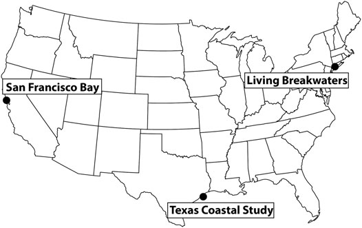
FIGURE 1. Overview map of project locations.
2 Methods
A series of web panels was held in October and November 2020 entitled “Innovations in Nature-Based Systems for Coastal Protection” as part of Coastlines & People (CoPe) Research Coordination Network (RCN) funded by the US National Science Foundation. The web panels were recorded and can be accessed at https://www.umces.edu/cope/events. The final list of web panel titles and panelists, and Steering Committee members, is provided in Table 1. The focus of these panels was initially developed by the Steering Committee, with the intention of featuring one project along each of the continental US’s ocean coastlines (East, West, Gulf) and one international project. Steering Committee members identified potential projects in each geographic region and contacted relevant partners to help select panelists. The goal was to select large-scale projects with diverse approaches that were not yet completely constructed and had willing panel participants. While there are many other projects we could have selected, we feel that the insights gained from three case studies selected highlight emerging themes that are broadly applicable to other NNBF projects.
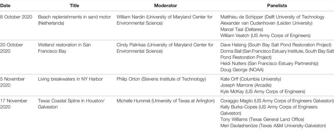
TABLE 1. Steering Committee Members: Cindy Palinkas [University of Maryland Center for Environmental Science (UMCES)]; Philip Orton (Stevens Institute of Technology); Michelle Hummel (University of Texas at Arlington); William Nardin, Matthew Gray, Ming Li, Lora Harris (UMCES); Ariana Sutton-Greir (University of Maryland College Park).
The Steering Committee and panelists co-developed the focus and initial content of each panel, which followed the same structure of ∼30 min of introductory presentations by panelists followed by ∼45 min of discussion moderated by a Steering Committee member and including attendees as active participants. We focused these discussions on implementation and design, funding, and stakeholder engagement; from our perspective, these aspects make NNBF projects unique relative to gray infrastructure and are often the most challenging. We used a structured analysis approach and asked panelists to comment on these aspects, highlighting successes and challenges, as well as lessons learned from their experiences. More than 700 people registered for the series, with ∼200–300 attending the live sessions, from a variety of fields (e.g., academia; local, state, and federal agencies; non-profits; private industry) and geographies.
Using content shared prior to and during the panels, the Steering Committee developed descriptions for each case study and synthesized lessons learned across all panels. These were refined during a meeting that included all panelists and the Steering Committee and informed the rest of the paper. The first panel focused on the Sand Motor project in Netherlands, which is well described in the first volume of the EWN Atlas (Bridges et al., 2018) and other publications (e.g., Stive et al., 2013; Brière et al., 2018; Luijendijk and van Oudenhoven 2019; de Schipper et al., 2020). Rather than repeating those details, we have chosen to omit it as a specific case study and instead focus on the other three projects. These three projects (described below) are in different phases of development. The Living Breakwaters project in New York Harbor has obtained funding and worked with stakeholders to refine the design plan; its construction began in August 2021. The Coastal Texas Protection and Restoration Project in the Gulf of Mexico is still in the study phase, awaiting submission to Congress for authorization of federal funding. If authorized, it will then proceed to the design and implementation phases. South Bay Salt Ponds in San Francisco Bay is the most mature project, having completed the initial phase of implementation in 2014. This project has a robust adaptive management plan, so that results from the first phase informs project designs and the science program for subsequent phases, including an established program for stakeholder engagement and long-term plans for monitoring and performance assessments.
3 Case Study Descriptions
3.1 Living Breakwaters—New York Harbor
The Living Breakwaters project is being built in the waters of Raritan Bay (Lower New York Harbor) along the southernmost part of Staten Island’s eastern shoreline (Figure 2). The project area is a shallow estuary that has historically supported commercial fisheries and shell fisheries. The area was heavily impacted by Hurricane Sandy in October 2012, which damaged or destroyed an unprecedented number of homes and businesses and caused loss of life and significant harm to the local economy. In response, a design competition, Rebuild by Design, was launched by the Hurricane Sandy Rebuilding Task Force to “couple innovation and global expertise with community insight to develop implementable solutions to the region’s most complex needs” (Grannis et al., 2016) (http://www.rebuildbydesign.org/our-work/sandy-projects). The Living Breakwaters project resulted from a winning entry to this competition, with the competition and initial design phase occurring in 2013–2014.
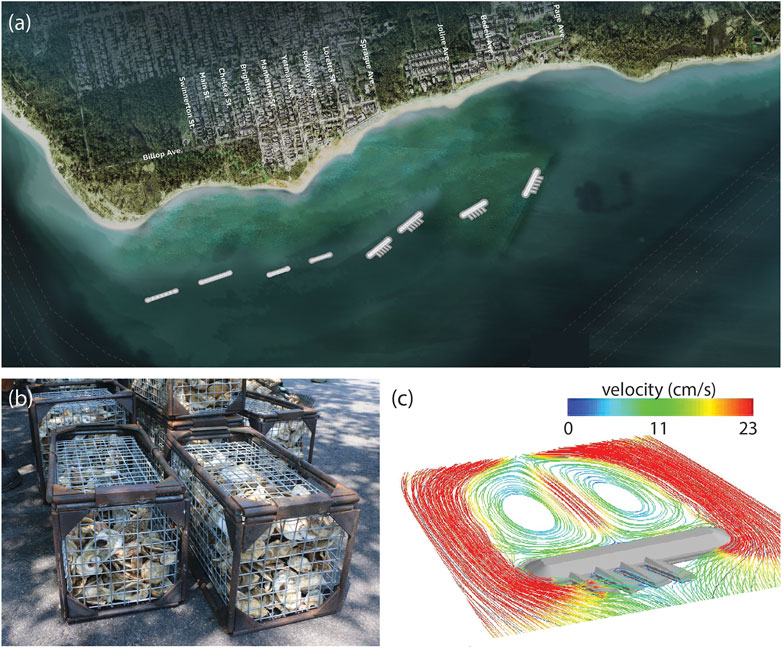
FIGURE 2. (A) The Living Breakwaters project will construct a series of breakwaters in Raritan Bay, offshore of Staten Island. (B) The breakwaters are designed to provide habitat for marine life, including oysters. (C) Sample breakwaters (shown in gray) include a main breakwater plus “reef streets” angled outward. These were tested using computational fluid dynamics modeling to evaluate and optimize designs for avoiding scour and sedimentation.
3.1.1 Innovative Coastal Design
The Living Breakwaters project innovates by integrating risk reduction, ecological enhancement, and social resilience (Tschirky et al., 2018). The project consists of approximately 2,500 linear feet (∼760 m) of nearshore “breakwaters,” or partially submerged rubble-mound structures located between 790 and 1,800 ft (∼240 and 550 m, respectively) from shore (Figures 2A,B). With regards to risk reduction, the project addresses both event-based and long-term shoreline erosion to preserve or increase beach width and provides wave attenuation to improve safety and prevent damage to buildings and infrastructure. The breakwaters are designed to reduce the height of wind-driven waves reaching buildings and roads to less than 3 ft (∼1 m) during a 100-year storm event with up to 18 inch (∼45 cm) of sea-level rise (SLR). They are not designed to reduce storm surge but instead cause wind waves to break further offshore, reducing wave run-up onto land and potentially also reducing the effect of waves on the surge (termed “wave setup”). Even as the breakwaters are more frequently submerged by storm surges with higher SLR, hydrodynamic modeling indicates that they will continue to provide wave attenuation (Marrone et al., 2019). The project also includes one-time sand replenishment to enhance beach width along the narrowest stretch of shoreline. Extensive computational fluid dynamics modeling and scaled physical laboratory modeling was utilized to optimize design, ranging from evaluation of the effectiveness of the entire set of breakwaters to reduce erosion and accrete beach over time, down to design of individual breakwaters to avoid scour and sediment accretion (Figure 2C; Marrone et al., 2019).
In addition to risk reduction, the project is also meant to increase the diversity of aquatic habitats, especially hard-structured habitats that can function much like the historical oyster reefs that once existed in Raritan Bay. In particular, the breakwaters were designed as rubble-mound structures with outer layers consisting of armor stones of varying sizes and ecologically enhanced concrete armor units that provide textured surfaces to promote biological activity and species recruitment. The structures also include “reef streets,” narrowly-spaced rocky protrusions on the ocean side of the breakwaters, to increase habitat diversity (Marrone et al., 2019).
The benefits of detached breakwaters for coastal protection have been known for decades (e.g., Chasten et al., 1993), and oyster reefs have been gaining appreciation as a new NNBF option (e.g., Piazza et al., 2005; Reguero et al., 2018). However, their combination, the urban setting, and the social components of LB are innovations on these concepts. The project uses education, outreach, and workforce training to spread awareness about harbor restoration activities and to encourage stewardship of the harbor. It also aims to increase physical and visual access to the shoreline and nearshore waters for enhanced recreational use.
3.1.2 Stakeholder Engagement
The community-based design process engaged a range of stakeholders such as regional experts, government entities, elected officials, issue-based organizations, local groups and individuals. Stakeholder engagement during the Rebuild by Design Competition led to improved understanding of current vulnerability and future threats, while at the same time raising public expectations about grantees meeting grand challenges with constrained budgets (Grannis et al., 2016). After LB was selected as winner of the Rebuild by Design Competition, the Citizens Advisory Committee (CAC) formed in 2015. The CAC intended to serve in a community-based advisory role to the project while leaving additional input from the public during public engagements and workshops. The NY Governor’s Office of Storm Recovery “encouraged applications from all variety of individuals and organizations in order to represent the diverse community of Staten Island and the region who the project will serve” (https://stormrecovery.ny.gov/LBWCAC). There were nine CAC meetings between July 2015 to July 2018.
Stakeholder input led to many adjustments to the project, including the project location, breakwater height, and an initial land-based “water hub” concept evolved and eventually changed form altogether to become a floating hub. Moreover, stakeholder input also informed project priorities and helped ensure the retention of critical features of the project, including ecological elements, through the design process when budgetary concerns often lead to loss of non-protective features of NNBF projects. Additionally, the iterative process of reviewing and updating designs with public input garnered greater public support for the projects over time.
3.1.3 Funding and Implementation
The project was implemented using $60M of Community Development Block Grant Disaster Recovery (CDBG-DR) funding as well as $14M of funding from the State of New York. An environmental impact statement (EIS) was completed in 2018, and necessary state and federal permits were secured soon thereafter. The project construction began in August 2021 with a projected completion date of Fall 2024.
3.1.4 Ecosystem Services and Connectivity
Given that a fundamental goal of the project is ecological enhancement, several ecosystem service benefits are part of the design. Ecosystem service values for the project were estimated using a biome-based spatial approach, using the net change in habitat area with areal habitat dollar values obtained from published literature sources (NYS-GOSR 2021). Biomes with positive net change in value included oyster habitat/reef sustainability, increased productivity of commercial finfish and crustaceans, shoreline stabilization, water quality improvements (nitrogen removal and SAV enhancement), and refugia. The only negative (gross) ecosystem services were related to loss of relatively lower-value sandy subtidal habitat under the footprint of the breakwater structures (NYS-GOSR 2021). Also, there were hopefully limited negatives with regard to ecological connectivity, since the breakwaters could cause increased long-term sedimentation and reduced circulation behind them.
3.2 Coastal Texas Protection and Restoration Study—Gulf of Mexico
The Coastal Texas Study was undertaken to address habitat loss and the range of hazards faced by coastal areas in the state, including erosion, sea-level rise, and storm surge (Figure 3). It seeks to determine the feasibility of Coastal Storm Risk Management (CSRM) and Ecosystem Restoration (ER) measures to protect the state’s communities, critical economic functions, and environmental assets (US Army Corps of Engineers and Texas General Land Office, 2020; https://coastalstudy.texas.gov). The scope of the project covers the entire Texas coast, from the Sabine River to the Rio Grande River, including all coastal areas and interconnected ecosystems in the state’s 18 Gulf Coast counties.
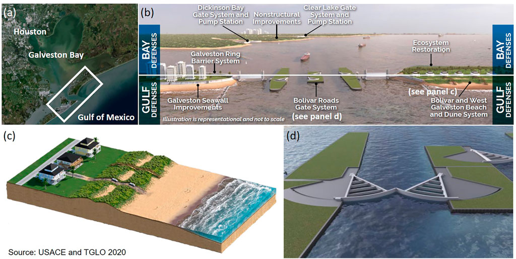
FIGURE 3. (A) Overview of the Coastal Texas Study area. (B) The study proposes a multiple lines of defense approach for Galveston Bay that includes gulf defenses along the outer barrier island coast as well as bay defenses to provide residual risk reduction within the bay. The gulf defenses include (C) restored beach and dune systems along Bolivar Peninsula and (D) a gate system at Bolivar Roads, the primary connection between Galveston Bay and the Gulf of Mexico.
3.2.1 Innovative Coastal Design
The project aims to minimize economic damage from coastal storm surge, inland and Gulf shoreline erosion, and restore threatened and endangered critical habitats hydrology to key lagoons. This is accomplished through a multiple-lines-of-defense strategy that combines structural, nature-based, and non-structural features to provide coastal resilience through implementation of robust and redundant protective features similar to the “double-insurance” framework of Andersson et al. (2017). A tentatively selected plan was identified in May 2018, followed by draft reports integrating feasibility and environmental impacts for public, policy, and peer review, with the goal of advancing the project to Congress for authorization of construction funding in 2022. The comprehensive plan consists of 1) an ER component that covers 6,600 acres (∼27 km2) of the coast to restore fish and wildlife habitat, improve hydrologic connectivity, and create and restore oyster reefs, marshes, dunes, and islands that provide protection for communities and infrastructure; 2) a CSRM component for 2.9 miles (∼4.7 km) of beach nourishment on South Padre Island along the lower Texas coast; and 3) a final CSRM component for the Houston-Galveston region spanning 63 miles (∼101 km) of the upper Texas coast to reduce storm surge entering Galveston Bay. This largest component, referred to as the Galveston Bay Storm Surge Barrier System, deploys a multiple-lines-of-defense approach intended to offer redundancy with the goal of mitigating storm surge impacts and improving the resilience for residents, industry, and ecosystems in the Houston-Galveston region. It includes a 2.8-mile (∼4.5-km) long gated surge barrier system across the Galveston Bay entrance, improvements to the existing Galveston Seawall, and 43 miles (∼69 km) of beach and dune systems on Galveston Island and Bolivar Peninsula, as well as strategies to mitigate residual risk from bay water surges, including additional gate closures and pumping stations at Clear Lake and Dickinson Bay on the mainland, a ring barrier for the backside of the City of Galveston, and additional nonstructural improvements on the mainland including floodproofing and raising of at-risk structures. The ER components target eight locations along the coast and include the construction of 114 miles (∼183.5 km) of breakwaters, 15.2 miles (∼24.5 km) of bird rookery islands, 2,052 acres (∼8.3 km2) of marsh, 12.3 miles (∼19.8 km) of oyster reef, and 19.5 miles (∼31.4 km) of beach and dune restoration (US Army Corps of Engineers and Texas General Land Office, 2020).
3.2.2 Stakeholder Engagement
The scoping process included federal, state, and local agencies and tribal nations, which met monthly to discuss study details and progress. Additional interagency and international workshops were held to discuss alternatives, performance metrics, and adaptive management approaches, among other aspects. Prior to the COVID-19 pandemic, a series of face-to-face public hearings and outreach meetings were held to solicit public comments on the plan and to inform the public regarding project updates (recordings are available at https://coastalstudy.texas.gov/get-involved/public-meetings/index.html). Community feedback led to changes to the plan, which originally included a floodwall over 17 ft (∼5.2 m) high to protect the barrier islands along Galveston Bay’s Gulf of Mexico shoreline. Local communities objected to this floodwall solution for a variety of reasons. After the USACE received more than 13,000 negative comments to this effect, they revised their plans and moved toward a more nature-based solution of beach and dune systems on the fronts of the barrier islands. It should be noted that this modification came with an increase of potential residual risks, but the tradeoffs offered an opportunity to better balance engineering performance, costs, benefits (i.e., returns on investment), and fewer environmental impacts resulting in a more socially acceptable solution. During the COVID-19 pandemic, the study team could not host face-to-face public outreach activities, and as a fallback developed an interactive GIS-based driven StoryMap system to offer the public an opportunity to engage with the study team virtually and explore the recommended plan through an interactive experience medium (https://coastal-texas-hub-usace-swg.hub.arcgis.com/).
3.2.3 Funding and Implementation
The US Congress appropriated $20.6 million to USACE over the course of the study in cooperation with the Texas General Land Office (TGLO), the non-federal cost-share sponsor, to complete the study effort. The estimated construction first-cost (in 2021 dollars) for the recommended plan is $28.9 billion, with 69% of the cost for Gulf Coast defense in Houston-Galveston and South Padre Island, 22% for bayshore defense in Houston-Galveston, and 9% for ecosystem restoration. The estimated average annual operation, maintenance, repair, replacement, and rehabilitation costs are $131 million, which must be shouldered solely by the construction sponsor. Recent scholarly research demonstrated economic benefits of a coastal barrier for the communities along the upper Texas coast to outweigh its engineering costs (Davlasheridze et al., 2019) and also looked at its significance in terms of buffering negative ripple effects on the economies of other states and the nation as a whole (Davlasheridze et al., 2021). To proceed to construction, funding must be authorized and appropriated by Congress, and cost-share sponsors must be identified. The recent Senate Bill 1160, passed on 16 June 2021, authorized a creation of the “Gulf Coast Protection District,” a five-county taxing authority (https://legiscan.com/TX/drafts/SB1160/2021) and corresponds to the latest developments towards realization of the coastal-defense system for upper Texas coast communities. The bill creates a formal mechanism for the district to partner with USACE and contribute towards funding, construction, and maintenance of a coastal barrier by taxing, issuing bonds, and other financial instruments. In addition, the Texas General Land Office will serve as an additional cost-share sponsor for the ER and South Padre Island components.
Design is expected to take 2–5 years to complete (per component), and construction is expected to take an additional 10–15 years after that. The project will be maintained for a minimum of 50 years by local sponsors. The average annual costs for operation, maintenance, repair, rehabilitation, and replacement during this period are estimated at $131 million. This includes funding for periodic nourishment of restored beaches and dunes on Bolivar Peninsula and West Galveston Island every 6–7 years. As the project moves into the next phase, the project team will continue to engage with stakeholders and the public at large through the interactive StoryMap tool.
3.2.4 Ecosystem Services and Connectivity
A main goal of the Coastal Texas Study is to improve hydrologic connectivity while restoring or creating fish and wildlife habitat and natural features to provide coastal protection for communities and infrastructure. Specifically, this includes a designed system to reduce storm surge entering Galveston Bay. The full project incorporates several types of restoration actions including marsh restoration, island creation/restoration, dune and beach restoration, oyster reef creation/restoration, and hydrologic restoration. Each proposed ER action was evaluated by simulating the change in number of habitat units available for target species, compared to the no-project condition. Tools such as the Habitat Evaluation and Assessment Tool (HEAT), Habitat Suitability Index (HSI), and the Wetland Value Assessment (WVA) were used based on the ecosystem type and species. Average annual habitat units calculated across the project planning period were then used to develop the final suite of ER actions described in Section 3.2.1.
Together, the ER components of the project are designed to provide a range of ecosystem services for Texas coastal communities. They contribute to the primary risk-reduction goals of the project by preventing shoreline erosion and reducing inundation of populated areas. In addition, these projects can enhance local water quality and provide habitat for a variety of species of commercial and recreational value, including brown shrimp, brown pelican, Kemp’s Ridley sea turtle, oyster, and spotted seatrout.
3.3 South Bay Salt Ponds—San Francisco Bay, California
This panel had a wider focus than the others, since restoration in San Francisco Bay often occurs within a regional context. The panel included experts from the NOAA National Estuarine Research Reserve System (NERRS), San Francisco Estuary Partnership, California State Coastal Conservancy, and San Francisco Estuary Institute, providing perspectives from federal, state, local, and non-profit stakeholders. Many San Francisco Bay projects take regional strategies into consideration as part of their planning and implementation. These strategies include the San Francisco Bay Subtidal Habitat Goals Project (Subtidal Goals 2010), Baylands Habitat Goals Update (Goals Project 2015), Comprehensive Conservation and Management Plan for the San Francisco Estuary (2016), the San Francisco Bay Shoreline Adaptation Atlas (Beagle et al., 2019), and the recent effort to establish a regional monitoring program through the Wetlands Regional Monitoring Program (WRMP; https://www.sfestuary.org/wrmp). The WRMP Program Plan was released in April 2020, with the intention of full program implementation by 2022. The development of the WRMP included a process that engaged hundreds of experts around the Bay Area in designing the overall plan and the science framework. We focus on one specific project for the case study—South Bay Salt Pond Restoration Project (SBSP; https://www.southbayrestoration.org)—and provide insights from regional collaborations in the discussion of common themes below (Figure 4). While the SBSP Restoration Project has been featured in other publications (Chapple and Dronova 2017; Gies 2018; DeAngelis et al., 2020; also see https://www.southbayrestoration.org/news-items), the project continues to evolve and has entered its second phase of construction.
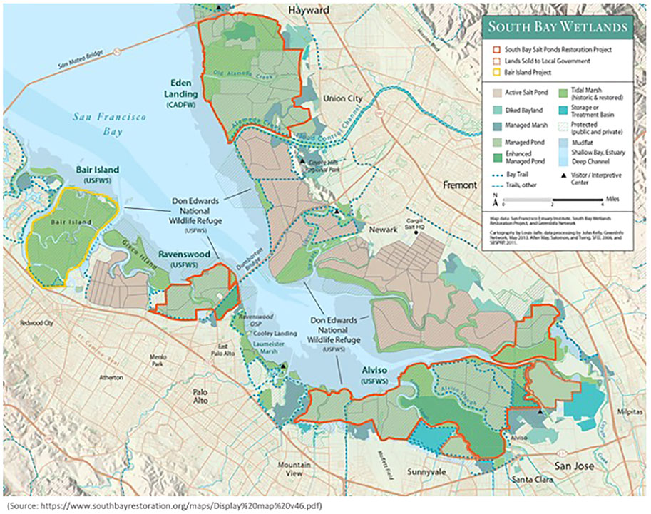
FIGURE 4. Map of the South Bay Salt Pond Restoration Project in San Francisco Bay.
3.3.1 Innovative Coastal Design
The SBSP Restoration Project is the largest tidal wetland restoration project on the US West Coast (15,100 acres, ∼60.7 km2), seeking to restore multiple former salt-production ponds back to natural conditions like tidal marshes and other aquatic habitats (Valoppi 2018). In addition to restoration, the project will provide regional flood risk reduction by absorbing tidal energy instead of reflecting it, reducing tidal amplitudes far beyond the project, to varying degrees across all of San Francisco Bay (Holleman and Stacey 2014).
The project integrates three main goals: 1) habitat restoration that focuses on a range of special-status species, primarily tidal-marsh species but also species (mainly birds) that used ponded areas during the salt production era; 2) protection from tidal flows brought closer to developed areas as leveed salt ponds are opened up; and 3) addition of wildlife-compatible public access features to connect people with the Bay while providing wildlife access and habitat. The SBSP Restoration Project is implemented on lands within a state ecological reserve (Eden Landing Ecological Reserve) and a national wildlife refuge (Don Edwards San Francisco Bay National Wildlife Refuge), and it is located in three counties, underscoring the importance of a regional approach to coastal management. Phase 1 occurred from 2007–2014, restored 3,000 (∼12.1 km2) acres of tidal marsh, made improvements to >700 acres (∼2.8 km2) of managed ponds to target pond-dependent wildlife, built islands and installed water management structures, and added 7 miles (∼11.3 km) of trails, mostly on levees, viewing platforms, a kayak launch, and historical exhibits. The project is in the earliest phases of Phase 2, which seeks to return tidal flows to additional areas, enhance pond habitat in other places, add trails, and integrate flood-protection projects with several external partner agencies. The SBSP Restoration Project includes an adaptive management program that uses a “restoration staircase” concept to address questions of adaptation and resilience, inserting intentional pauses to evaluate how habitats are evolving and how wildlife are responding. For example, before moving to Phase 2, the program worked with scientists to evaluate past performance and suggest possible adaptation measures to adjust project designs and refine the science program for Phase 2. These measures include anticipated effects of climate change and emerging technologies, as well as potential funding and communication mechanisms. Insights from this process and other regional planning efforts such as the Adaptation Atlas (developed by the San Francisco Estuary Institute; Beagle et al., 2019) help to identify types of adaptation strategies for consideration at specific sites.
Both the regional WRMP and the SBSP Restoration Project face potential challenges to success. For the WRMP, the biggest challenge is serving such a broad community of interest while remaining technically rigorous. There is a constant driving need to produce great science, but the process can overpower a Program like this one if all interested parties are at the table. For example, balancing trade-offs of serving such a broad community of stakeholders and of inclusion and focus when it comes to program development can be difficult. For the SBSP Restoration Project, challenges include climate change and other environmental changes that affect flooding and sediment supply to sustain the establishing tidal marshes. Project actions have the potential to increase bioavailable mercury and negatively impact the food web, as well as invasive species expansion. South Bay Salt Pond Restoration Project Adaptive Management Plan, (2007) is specifically designed to address these, and many other, uncertainties as the project continues, directly informing design and implementation of each phase of the project.
The marsh restoration areas are meant to have an indefinite/permanent useful life, as they are primarily habitat features in an obviously dynamic and ever-changing environment. They are not necessarily intended to provide any specific degree of coastal resilience or flood protection on their own. The public access features such as levee-top trails, boardwalks, viewing platforms, etc. have useful lives of 30–50 years, with the 30 being the official “intended” useful life of those features. The water control structures and pond levees/berms used in the managed pond enhancements usually need constant maintenance and/or repair/replacement on the order of a decade or so.
3.3.2 Stakeholder Engagement
The Wetland Regional Monitoring Plan (WRMP) uses a collaborative, consensus-based approach for regulators, land managers, and scientists making decisions together, starting with management questions that drive monitoring down to the level of metrics, protocols, and indicators, then bringing in new questions to update metrics and protocols. It is a prime example of combining the technical foundation for the work with public engagement, listening to the underserved communities that are adjacent to restoration projects and any other interested community members. Indeed, extensive community engagement is becoming a basic foundational practice for designing restoration projects and is one of the core best management practices.
For the SBSP Restoration Project, outreach and stakeholder engagement efforts are led by the California State Coastal Conservancy and the Consensus and Collaboration Program at California State University Sacramento. Outreach is a critical part of the entire project, since it is one of the largest restoration projects in the US and takes place in one of the most densely populated regions of California with many different user groups, interests, neighboring landowners, and stakeholders. The major venue for the public to provide advice and recommendations to the Project Management Team is through the Stakeholder Forum, a group of 25 individuals representing local businesses, advocacy groups, elected officials, recreational groups, and others. Input from extensive interviews with a wide range of stakeholders prior to implementation resulted in the current stakeholder process that provides opportunities for input at each phase of planning (California State University Sacramento, 2003). This feedback, and recognition of the additional challenges of climate change on this system, led to recent recommendations to increase regional coordination and engagement to enhance adaptive management moving forward. This is recognized as an important theme for all regional planning. Indeed, the Baylands Goals Science Update for the San Francisco Bay area (Goals Project 2015; https://www.sfei.org/projects/baylandsgoals) made several recommendations for climate planning in the region that included centralizing data for better coordination and facilitating dialogue to promote information diffusion among stakeholder groups.
3.3.3 Funding and Implementation
In 2003, 15,100 acres (∼61.1 km2) of commercial salt ponds were acquired from Cargill, Inc. for $100 million, funded by federal and state resource agencies and several private foundations. Funds for implementation of the South Bay restoration, flood management, and public access plan to date have come from a mix of sources, including local, state, and federal funds, as well as private funds from foundations or other non-governmental organizations. The largest sources of ongoing funding for restoration planning, design, permitting, and construction are competitive federal, state, and regional grant programs, matched by in-kind contributions from the project partner agencies.
The South Bay project is being implemented in multiple phases over 50 years, using a robust adaptive management plan (AMP) to determine how far the system can move toward full tidal action and associated tidal habitats, while still meeting the other Project Objectives (Trulio et al., 2007). The AMP identifies restoration targets as well as triggers that may necessitate management actions. The organizational strategy includes an Executive Project Manager and Executive Leadership Group and a Project Management Team that regularly interacts with the Science Team, Regulatory and Trustee Agency Group, and Stakeholder Forum to ensure oversight and coordinate planning and implementation throughout the project (https://www.southbayrestoration.org/page/who-we-are-collaborative-team).
3.3.4 Ecosystem Services and Connectivity
The SBSP Restoration Project highlights the need to make sure habitats are not created for a single species but rather consider competing species’ needs. Indeed, one of the main goals of the SBSP Restoration Project is habitat restoration for a range of special-status species. While the focus is mostly on tidal marsh species, there is also a need to protect the many types of wildlife (mainly birds) that used the ponded areas during salt production. So, the project design needed to restore tidal marsh species while also providing for pond-dependent wildlife species and while connecting habitat via wildlife corridors. Another goal is to add wildlife-compatible public access features like trails and viewing areas to connect people with SF Bay and help them understand why restoration is needed. These goals and associated ecosystem services are not always compatible, making some trade-offs potentially necessary. For example, opening up the salt ponds and restoring tidal flows brought water closer to developed areas, resulting in a need to maintain or improve current levels of flood protection for those areas. This has entailed working with local flood protection agencies to incorporate their projects into the landscape with the restored sites.
Beyond the challenge of managing the competing goals for the project and the challenges of predicted effects of sea-level rise, the project provides an array of ecosystem services and greatly improved connectivity along the shoreline. The restoration supports baseline services and functions such as photosynthesis, nutrient cycling and provides habitat and nursery areas, increases biodiversity, and the transition zones designed into the project provide high tide refugia. Much of the habitat along the shoreline of San Francisco Bay has been reduced in size and suffered from fragmentation due to urban development. Increasing the area of tidal marshes is an important part of the design and will help to create larger, more connected patches of marsh habitat in the South Bay to allow movement of not only wildlife species, but of water, sediment and nutrients between the Bay and ponds that were previously restricted by berms and levees. Social and economic services are services that are especially important to people for cultural and social development and the Bay area will benefit from increased access to trails for hiking and biking, and birdwatching. This is a key issue for the region, and so it follows that evaluating how wetland restoration provides benefits to humans is one of the five guiding questions of the regional WRMP. This task will work to ensure that diverse voices are at the table in the WRMP process, and their interests are reflected in the suite of indicators monitored by the WRMP. Enhancing community engagement and ecosystem services evaluation will improve the ability of the WRMP to advance environmental justice and improve environmental conditions for communities disproportionately impacted by climate change and the loss of wetlands.
4 Discussion of Emerging Themes
Several common themes emerged from the three case studies that highlight factors contributing to and/or hindering success of innovative coastline management projects, depending on the context. We have organized the themes into two sections—areas of progress and remaining challenges. It is important to note that there have been advancements and challenges in every theme; the groupings are intended to guide readers rather than represent a hard boundary. Our goal is to glean lessons learned within each theme to inform future NNBF coastal resilience projects.
4.1 Areas of Progress
4.1.1 Moving Beyond Single-Benefit Projects
Historical approaches to coastal protection have focused on reducing potential damages from hazards such as flooding and erosion via gray infrastructure (e.g., levees, seawalls, and bulkheads) (Griggs 2005; Spalding et al., 2014). Despite the immediate and often substantial risk-reduction benefits provided by these structures, they offer minimal co-benefits and can even cause loss of coastal habitat and associated ecosystem services (Sutton-Grier et al., 2015). NNBF and hybrid approaches to coastal protection represent a promising alternative to gray infrastructure because of the many co-benefits that can be achieved, including wildlife habitat, recreation, water quality, and carbon/nutrient sequestration (Bridges et al., 2015). Additionally, the USACE has determined that NNBF projects that involve very collaborative, multi-disciplinary partnerships including landscape architects, engineers, and applied scientists, not only result in improved NNBF projects, but also improved communication and support for these types of projects (King et al., 2022). Hence, projects with multiple goals and multiple collaborators have many benefits.
Each case study started with an innovative framing, enabled through the funding sources themselves. The Rebuild by Design competition that resulted in the Living Breakwaters project encouraged innovation and broad interdisciplinary teams, with the goal of “promoting innovation by developing regionally scalable but locally contextual solutions that increase resilience in the region” (https://stageipk.es.its.nyu.edu/initiatives/rebuild-by-design/). The competition awarded projects that included strong engagement of local communities and government stakeholders, driving projects to target a wider range of benefits than simple flood-damage reduction. In the case of the Coastal Texas Study, the authorization for the study was explicitly for “flood damage reduction” and “ecosystem restoration,” in contrast to other more typical feasibility studies (e.g., US Army Corps of Engineers, 2015; US Army Corps of Engineers, 2019) that were only authorized for damage reduction. The SBSP Restoration Project initiative sought co-benefits from the initial stages of planning for restoration, flood reduction and wildlife-friendly public access.
By leveraging nature-based and hybrid infrastructure, all three case studies move beyond a sole focus on safety and flood reduction to include multiple functions and benefits (Van Veelen et al., 2015; O’Shaughnessy et al., 2020). Complete elimination of risk is not the goal, nor is it realistic given anticipated increases in the rate of sea-level rise and storm intensity; instead, each project provides meaningful risk mitigation while also enhancing ecological and/or social resilience. For example, in addition to providing wave attenuation and erosion reduction, the Living Breakwaters project also aims to increase biodiversity, enhance shoreline recreational opportunities, and raise awareness of coastal resiliency and ecological health. The Coastal Texas Study includes numerous components aimed at creating or restoring natural features that provide habitat in addition to acting as barriers to storm surge or waves. The SBSP Restoration Project and other regional projects in San Francisco Bay are focused on ecological restoration rather than an explicit risk reduction component, although projects do include measures to ensure that flood risk for adjacent communities and infrastructure does not increase as a result of restoration actions. Also, enhancing recreation opportunities can be an important aspect for community buy-in and obtaining funding from multiple sources. For example, the SBSP Restoration Project has public access as one of its main goals and includes trails and viewpoints in almost all of the project sites.
Multi-functional projects such as these can address the needs of a variety of stakeholders and enable multiple pathways for a project to be successful, even if some aspects of the project do not end up working as well as others. For example, there has been increasing awareness by the public that the restoration of ponds at the edge of SF Bay may provide some protection against sea level rise for critical infrastructure, global technology companies, and other Silicon Valley businesses. As these case studies demonstrate, communities and stakeholders value natural habitats and the services they provide and may be more willing to support coastal resilience projects that include co-benefits such as maintaining ecosystem integrity and recreational access. An example of increased public awareness and support of wetland restoration includes the passage of Measure AA (San Francisco Bay Clean Water, Pollution Prevention and Habitat Restoration Measure)—the nine counties of San Francisco Bay voted for a 20-year, $12/year parcel tax that will raise $500 million for restoration projects in the Bay. The personal connection to the Bay by voters was one of the major factors for its success (https://www.sfbayrestore.org/overview). Given the multifaceted and interdisciplinary nature of NNBF projects, successful design and implementation requires expertise and cooperation across a variety of fields and sectors. Local system knowledge is critical to apply successful strategies from other projects, adapting them to address site-specific conditions. The projects described here include teams spanning a broad range of participants from architecture, engineering, ecology, economics, and/or social science representing state/federal agencies, consulting firms, and academia. These multidisciplinary teams reflect the importance of integrated thinking that considers the physical hazards alongside ecological and social responses.
4.1.2 Creating Opportunities for Natural and Nature-Based Features Through Co-Production of Project Designs
Input from the public is critically important since coastal resilience projects not only affect local communities and the environment but also people’s lives. As a result of the potential negative side effects of protecting coasts with gray infrastructure, including degraded habitat, loss of shoreline access, and impacts on neighboring properties, gray projects have faced opposition from stakeholders and the public in the past (Griggs 2005). For example, a project in Ventura, California to prevent shoreline erosion by constructing a seawall was opposed by local stakeholders, including the Surfrider Foundation and the California State Coastal Conservancy, in the 1990s. Instead, the interested parties agreed upon a managed retreat approach (Surfer’s Point Managed Shoreline Retreat; https://ventura.surfrider.org/surfers-point/) that allowed for habitat restoration and did not interfere with local hydrodynamics (Judge et al., 2017).
In contrast, coastal resilience projects that have stakeholder engagement as one of their explicit goals can incorporate feedback early and often as the project progresses. The Coastal Texas Study is an excellent example of feedback shifting the project design from a more traditional, gray approach to a more natural/hybrid solution. That project initially proposed a floodwall that was opposed by local residents, who sent thousands of negative comments to USACE. As a result, the project was redesigned to use a beach and dune system to reduce flooding from the Gulf instead. This solution provides fewer risk-reduction benefits but is more acceptable to the local community and provides more NNBF co-benefits.
Frequent and effective communication between the project team, stakeholders, and the public can contribute to a more transparent process that includes opportunities for input and adjustments, helping to build trust and buy-in (Paul et al., 2018). The case studies here, especially Living Breakwaters and the Coastal Texas Study, highlight the importance of clear communication. For example, in the Living Breakwaters project, being transparent in the process about what the project could and could not do was critical for developing trust with everyone involved. This project made it clear from the beginning that the goal was not to keep flood waters out of the area but rather to restore ecological systems, reduce the risk of erosion and wave damage, and enhance social outreach and education. The project team specifically engaged with stakeholders before truly beginning the design to establish project goals and trade-offs, ultimately producing hundreds of pages of information for the Environmental Impact Statement (EIS). For the Coastal Texas Study, following the release of the first Draft EIS, there was widespread misunderstanding among locals about the proposed plan, and misinformation was spread on social media. The project team learned from this experience and conducted a much more extensive outreach and public education campaign prior to the release of the revised Draft EIS, which resulted in more productive exchanges between the project team and the public.
4.1.3 Managing Uncertainty in Project Performance
Unlike engineered structures that have a set of well-defined design criteria, there are uncertainties in quantifying the capacity of nature-based systems to withstand extreme events and determining the breakpoints at which such a system is expected to either fail to provide its required engineering service or itself be destroyed due to the environmental conditions. This requires a flexible design approach that can not only satisfy short-term needs but also allow for future adjustments to meet long-term goals. It also requires a post-construction monitoring program to document the performance of these systems and may require a greater commitment to ongoing maintenance to achieve a desired level of protection than traditional approaches. Since these systems are innovative, guidance on expected outcomes (e.g., amount of sediment accretion that will occur over time) is lacking, especially compared to decades of experience with gray infrastructure, and engineers may have more comfort with materials that have documented factors of safety. It can also be a challenge to predict the long-term evolution of NNBF and to scale up from small-scale to larger-scale applications. For example, in the Sand Motor project in Netherlands, the uncertainty in the predicted evolution is a mixture of both uncertainty in model formulations in current state of the art models and the uncertainty in future (wave) forcing (Kroon et al., 2020). This is especially important since there is a large natural variability in ecology and still many unknowns on how habitat attributes result in changes in biodiversity and species richness.
Thus, it is critical that learning from NNBF projects also be one of the multi-functional goals, so that we can learn as much as possible from every project. For example, because there is no “one-size-fits-all” natural infrastructure design for all contexts (Sutton-Grier et al., 2015) and the coastal resilience ecosystem services provided by natural infrastructure vary by geomorphic setting and event conditions (Saleh and Weinstein 2016), one main research focus that is still greatly needed is better understanding of what approaches and strategies work well in which conditions (Smith et al., 2020). Additionally, we need to know how to effectively implement NNBF projects for coastal resilience, and how projects can address uncertainties and evaluate or weigh different components (e.g., using Ecosystem Services framework). Projects should define goals for long-term adaptability in the planning of the project and establish specific performance metrics and clearly defined goals (Arkema et al., 2017; Bayulken et al., 2021). In the Living Breakwaters project, modeling of waves, storm surge, and sediment movement in water and then onshore was a critical component to developing the design, and monitoring the project will be key to understanding how well the project is functioning for both ecological and risk reduction goals. In the SBSP Restoration Project, understanding how salt pond restoration would impact flooding and flood risk to human development has been key to planning to maintain or improve flood protection for those communities as part of the restoration design.
There is a general focus on “no-regrets” strategies by assessing adaptability to climate change via stress tests under higher sea levels. The Coastal Texas Study evaluated project alternatives under low, intermediate, and high SLR scenarios through 2,135 and includes a plan for monitoring and adaptively managing the ecosystem restoration components of the project to ensure that project objectives are met across the lifetime of the project. It also utilizes a multiple-lines-of-defense approach to provide redundancy in coastal protection and address possible failure modes. For example, possible breaching of the dune barrier system during large storms is addressed by including bay-side defenses and by elevating structures. The SBSP Restoration Project explicitly includes adaptive management, so that lessons learned from Phase 1 can be incorporated into Phase 2 plans and future phases along with new insights from emerging science and technology. Adaptive management via engaging scientists and stakeholders is a key part of the WRMP in San Francisco Bay, in which lessons learned from designing, implementing, and monitoring for one project will inform other projects at local and regional scales.
4.1.4 Expanding Beyond the Project Scale to a Regional Perspective
Possibly because of the stakeholder engagement and the focus on multiple benefits of each project, as well as the need to design multiple features to achieve many aspects of resilience, NNBF projects are often part of a suite of projects to build resilience across a broad region. This is a strength of the NNBF approach, because there can be a larger focus on how individual projects fit together into a coastal system designed for resilience. Connectivity of multiple projects along a coastline can be part of the design of NNBF projects particularly in urban settings in order to counter past loss of coastal ecosystems and biodiversity (Aguilera et al., 2020). For example, in the Coastal Texas Study, there are many different resilience approaches across an entire region that are combined into one larger project with multiple goals—restoring fish and wildlife habitat; improving hydrologic connectivity; creating and restoring oyster reefs, marshes, dunes, and islands that provide protection for communities and infrastructure; renourishing beaches; installing a new tidal gate; and improving a seawall. In the SF Bay, once developed, the WRMP would integrate monitoring, reporting, and data-sharing across a wide range of projects to improve uniformity, consistency, currency, and other aspects of data. The project itself is also taking into account that as a result of the restoration of tidal flows, flood risk on different parts of the landscape is changing, and so maintaining and improving flood protection is part of the design of the project to help address the changes taking place across the landscape as restoration reconnects parts of the landscape that were previously separated by the salt ponds. Taking a regional approach to resilience and incorporating NNBF projects is a critical, forward-looking step in improving coastal resilience.
4.2 Remaining Challenges
4.2.1 Navigating Permitting and Policy Barriers
A significant barrier to the widespread implementation of innovative NNBF projects is the permitting process for new designs, which is often complex and may need quite a lot of lead time. Permits may be required at the local, state, and/or federal level. There may be many steps, and regulators may be seeing this type of innovative project for the first time. Again, the importance of being transparent and doing outreach and education as part of these projects applies to getting regulatory and community buy-in. For example, a key to facilitating the permitting process for the Living Breakwaters project was to have a clear purpose and need statement that included all of the project benefits (risk reduction, ecological enhancement, and social resilience) and to have a robust and transparent dialog with the regulatory community early and often to help craft a permitting path that was appropriate for the project’s innovative approaches.
Many panelists described the frustrations and challenges with regulatory barriers that made projects more difficult. Oftentimes the policies are well-meaning environmental regulations that aim to protect people and ecosystems, and yet make it challenging to be innovative in the coastal resilience setting. For example, regulations around the use of “fill” (e.g., sand or silt dredged from a location often for maintenance needs such as navigable shipping channels) in wetlands were initially designed to protect wetlands and generally did not include anticipated effects of climate change or potential opportunities to use fill to enhance or restore coastal environments when they were implemented. Because they are legal requirements, regulatory agencies may have to undergo a lengthy legal process to grant permits to allow use of fill in wetlands. Even given the challenges of addressing this barrier, it is important to change the conversation on fill from seeing it only as a pollutant to considering it as a possible asset to NNBF projects. Restrictions on fill use was a challenge to the Living Breakwaters project design. In San Francisco Bay, the Bay Conservation and Development Commission, the regional body charged with managing the Bay coastline, is doing just that and changing its policy to allow the use of fill for restoration and environmental enhancement projects while still maintaining restrictions on the use of fill for development projects. At the federal level, USACE is increasingly exploring opportunities to incorporate NNBF into coastal risk-reduction projects, as evidenced by the Coastal Texas Study and EWN efforts, including the use of fill for beneficial reuse. However, there are still limitations in the use of dredged material across multiple projects that will require innovations in policy and blending of funds. Thus, more research on the appropriate use of fill is needed to inform potential changes in regulations that could facilitate more NNBF projects. This type of innovation in the policy space is going to continue to be needed to support more NNBF projects.
Successful permitting and implementation of multi-objective projects may also require a rethinking of how project planning is conducted within and between mission-focused agencies, as projects that move outside of the stated mission may be difficult to justify and fund. This siloing of projects within existing agency boundaries to avoid “mission creep” may miss out on opportunities to achieve multiple benefits across a range of objectives. Thus, while there has already been some progress to address these barriers, they will likely continue to be a challenge for innovative coastal resilience projects until these innovations become more of the “norm.”
4.2.2 Funding
Several panelists identified funding as a critical need for both project development and long-term monitoring after implementation. This is a continuing challenge, especially in the US, where funding for resilience projects is primarily often tied to the disaster-response cycle (NRC, 2014). The Living Breakwaters project is an excellent example of a project that arose after a major disaster; if it had been implemented before Hurricane Sandy, it may have protected the coastline from some damages. It is important as a society that we start making investments in resilience projects that are not tied to the disaster-response cycle. We need to be anticipatory and fund the development and implementation of these projects during “blue-sky” periods before the next big storm (e.g., Reguero et al., 2020). This would allow projects to not be rushed and to have more certainty about funding opportunities.
When NNBF projects are funded in a post-disaster context, there is often a firm and short timeline on funds, prohibiting post-installation monitoring. Yet such monitoring can help define “success” of a project and inform other projects or other phases of the existing projects. In response to a vacuum of long-term monitoring of NNBF projects after Hurricane Sandy, a New York State-funded team and stakeholders recently co-created a state-level monitoring program (Wijsman et al., 2021).
An ongoing monitoring program can be planned during project design that is rigorous but not so much that it becomes onerous or burdensome to fund and/or conduct over the years. For example, the Living Breakwaters project was designed to enable long-term monitoring to learn more about which specific breakwater designs and parameters are more likely to be effective to help inform adaptive management efforts and future projects. However, future funding will still be required for the actual research and measurements in this project. The SBSP Restoration Project offers a success story in which the investment of funding for long-term monitoring in the first phase of the project has informed the planning for the next phase, as well as providing valuable insights for other projects in the region.
Cost-sharing requirements can also place a limitation on the long-term maintenance and monitoring of NNBF projects. For example, in the Coastal TX Study, the ecosystem restoration alternatives were initially meant to include funding for nourishment if needed in response to changing conditions and sea-level rise. However, the cost of maintaining ecosystem restoration measures, which are required to be self-sustaining, could not be cost-shared, so this was later removed from the recommended plan. If nourishment is deemed necessary during the post-project monitoring period, the required work will have to be authorized separately at that time. Without proper funding to maintain ecosystem restoration components, the long-term survival and performance of these systems may be constrained. In contrast, features that also included a risk-reduction component, such as the beach and dune restoration, do include funding for periodic nourishment to maintain protective benefits.
4.2.3 Defining and Assessing Project Costs and Benefits
There is also a need to broaden the thinking on cost-benefit analyses. These studies are commonly used to assess options and trade-offs for project alternatives, and yet have traditionally only included the costs of construction and the benefits of reducing flood risks provided by projects (e.g., Aerts 2018; Reguero et al., 2018; Waryszak et al., 2021). With the burgeoning of innovative NNBF projects with multi-functional goals, it is key that cost-benefit analyses include all the benefits these projects provide, including ecological, recreational, and other benefits, although these co-benefits can be hard to quantify in monetary terms (Sutton-Grier et al., 2015; Seddon et al., 2020). Each of our case studies addressed more than benefit-cost ratios for risk reduction, often in response to community input. In the Coastal Texas Study for example, the cost-benefit analysis included benefits to wildlife in addition to risk reduction benefits. For Living Breakwaters, the project team is specifically planning to monitor fish productivity on the underwater portions of the breakwaters to quantify the ecological benefits. In some cases, data may be lacking or very limited to inform cost-benefit analyses of these multiple benefits; however, this is one of the reasons why monitoring many aspects of these NNBF projects is key. We will learn from these projects and that new understanding of co-benefits can help inform cost-benefit analyses of future projects and address some of the hesitancy to give permits.
One of the unique elements of the Coastal Texas Study and Living Breakwaters project is a focus on co-benefits in the provision of dune habitat and oyster reefs, respectively. Without the context of serving as engineering structures, these elements alone might be considered ecosystem restoration. Here, the NNBF context reimagines a practical approach to incorporating these elements into levees and breakwaters and asks us to consider the phenomenological roots of “restoration” (see Hilderbrand et al., 2005; Hobbs et al., 2009; Hertog and Turnhout 2018). Certainly, these efforts are not restoring the system back to some historical state, but they replace lost restoration functions, and in this way, they lie in a grey area of restoration (e.g., “novel ecosystems”; Hobbs et al., 2013).
One recommendation for future projects and efforts in coastal resilience is to think specifically about what we can learn from each of these innovative projects because additional data on the performance, community outreach/stakeholder engagement, and socioeconomic components of NNBF projects is key to improving future projects (Smith et al., 2020; Bayulken et al., 2021). Collecting similar types of data from these and future projects would enable us to learn as much as possible from each project. We have included recommendations for the types of benefits or ecosystem services that NNBF projects should consider including in their monitoring plans (Table 2).
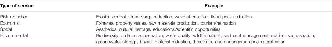
TABLE 2. Potential services provided by NNBF (Bridges et al., 2015).
This is not a comprehensive list by any means, but is a good starting point for thinking about the types of data we should collect across projects to help with project comparisons and to inform future planning and analyses. Considering a consistent and more complete set of services across NNBF projects could facilitate the evaluation, selection, and permitting of similar future projects. The goal of this case-study analysis, as well as the suggestions for data collection for future projects, is to facilitate additional innovative coastal resilience projects across the US and around the world.
Author Contributions
This paper was co-developed by the Steering Committee members and Panelists listed in Table 1. The Steering Committee wrote the first draft of the paper, led by CP, after which it was reviewed for feedback and input by the Panelists. All authors participated in subsequent rounds of revisions and editing. All authors have read and agreed to the published version of the manuscript.
Funding
We acknowledge funding support from National Science Foundation through the CoPe (Coastlines and People) RCN (Research Coordination Network): Advancing Interdisciplinary Research to Build Resilient Communities and Infrastructure in the Nation’s Estuaries and Bays CoPe RCN grant: ICER 1940273. CP was partially supported by the Grayce B. Kerr Fund. The funders had no role in the design of the study; in the collection, analyses, or interpretation of data; in the writing of the manuscript, or in the decision to publish the results.
Conflict of Interest
JM is employed by Arcadis.
The remaining authors declare that the research was conducted in the absence of any commercial or financial relationships that could be construed as a potential conflict of interest. The funders had no role in the design of the study; in the collection, analyses, or interpretation of data; in the writing of the manuscript, or in the decision to publish the results.
Publisher’s Note
All claims expressed in this article are solely those of the authors and do not necessarily represent those of their affiliated organizations, or those of the publisher, the editors and the reviewers. Any product that may be evaluated in this article, or claim that may be made by its manufacturer, is not guaranteed or endorsed by the publisher.
Acknowledgments
The authors would like to thank many colleagues, students, and staff for fruitful discussions on this topic. We especially thank the attendees of the web panel series, particularly those who actively participated via questions and comments in the chat and brought out additional facets of the projects beyond our initial panel planning. Constructive comments from 2 reviewers helped improve the original manuscript. This is contribution #6113 of the University of Maryland Center for Environmental Science.
References
Aerts, J. (2018). A Review of Cost Estimates for Flood Adaptation. Water 10, 1646. doi:10.3390/w10111646
Aguilera, M. A., Tapia, J., Gallardo, C., Núñez, P., and Varas-Belemmi, K. (2020). Loss of Coastal Ecosystem Spatial Connectivity and Services by Urbanization: Natural-to-Urban Integration for bay Management. J. Environ. Manage. 276, 111297. doi:10.1016/j.jenvman.2020.111297
Andersson, E., Borgström, S., and McPhearson, T. (2017). “Double Insurance in Dealing with Extremes: Ecological and Social Factors for Making Nature-Based Solutions Last,” in Nature-Based Solutions to Climate Change Adaptation in Urban Areas. Editors N. Kabisch, H. Korn, J. Stadler, and A. Bonn (Cham: Springer International Publishing), 51–64. Theory and Practice of Urban Sustainability Transitions. doi:10.1007/978-3-319-56091-5_4
Anguelovski, I., and Connolly, J. J. T. (2021). “Addressing green and Climate Gentrification in East Boston,” in The Green City and Social Injustice: 21 Tales from North America and Europe. 1st ed. (London: Routledge), 14.
Arkema, K. K., Griffin, R., Maldonado, S., Silver, J., Suckale, J., and Guerry, A. D. (2017). Linking Social, Ecological, and Physical Science to advance Natural and Nature-Based protection for Coastal Communities. Ann. N.Y. Acad. Sci. 1399, 5–26. doi:10.1111/nyas.13322
Bayulken, B., Huisingh, D., and Fisher, P. M. J. (2021). How Are Nature Based Solutions Helping in the Greening of Cities in the Context of Crises Such as Climate Change and Pandemics? A Comprehensive Review. J. Clean. Prod. 288, 125569. doi:10.1016/j.jclepro.2020.125569
Beagle, J., Lowe, J., McKnight, K., Safran, S. M., Tam, L., and Jo Szambelan, S. (2019). San Francisco Bay Shoreline Adaptation Atlas: Working with Nature to Plan for Sea Level Rise Using Operational Landscape UnitsSFEI Contribution No. 915. Richmond, CA: SFEI & SPUR, 255. Available at: https://www.sfei.org/documents/adaptationatlas.
Bilkovic, D. M., and Mitchell, M. M. (2013). Ecological Tradeoffs of Stabilized Salt Marshes as a Shoreline protection Strategy: Effects of Artificial Structures on Macrobenthic Assemblages. Ecol. Eng. 61, 469–481. doi:10.1016/j.ecoleng.2013.10.011
Bridges, T., Bourne, E. M., King, J., Kuzmitski, H., Moynihan, E., and Suedel, B. (2018). Engineering with Nature : An Atlas. Vicksburg, MS: US Army Corps of Engineers. Engineer Research and Development Center Special Report ERDC/EL SR-18-8. doi:10.21079/11681/27929
Bridges, T., Bourne, E., Suedel, B., Moynihan, E., and King, J. (2021). Engineering with Nature: An Atlas, 2. Vicksburg, MS: US Army Corps of Engineers. Engineer Research and Development Center Special Report ERDC/EL SR-21-2. doi:10.21079/11681/40124
Bridges, T. S., Burks-Copes, K. A., Bates, M. E., Collier, Z., Fischenich, C. J., Piercy, C. D., et al. (2015). Use of Natural and Nature-Based Features (NNBF) for Coastal Resilience. Washington, D.C.: US Army Corps of Engineers.
Brière, C., Janssen, S. K. H., Oost, A. P., Taal, M., and Tonnon, P. K. (2018). Usability of the Climate-Resilient Nature-Based Sand Motor Pilot, The Netherlands. J. Coast Conserv 22, 491–502. doi:10.1007/s11852-017-0527-3
California State University (CSU) Sacramento. 2003. Stakeholder and Organizational Assessment Findings and Recommendations by Center for Collaborative Policy. Available at: https://www.southbayrestoration.org/pdf_files/stakeholder_assess/Final_Assessment_Report.pdf.. (Accessed April 4, 2022).
Chapple, D., and Dronova, I. (2017). Vegetation Development in a Tidal Marsh Restoration Project during a Historic Drought: a Remote Sensing Approach. Front. Mar. Sci. 4, 243. doi:10.3389/fmars.2017.00243
Chasten, M. A., Rosati, J. D., McCormick, J. W., and Randall, R. E. (1993). "Engineering Design Guidance for Detached Breakwaters as Shoreline Stabilization Structure," in DTIC Document. Available at: http://oai.dtic.mil/oai/oai?verb=getRecord&metadataPrefix=html&identifier=ADA275241.
Comprehensive Conservation and Management Place for the San Francisco Estuary (2016). Available at: https://www.sfestuary.org/wp-content/uploads/2021/05/CCMPFinalOct2016.pdf. (Accessed April 4, 2022).
Davlasheridze, M., Atoba, K. O., Brody, S., Highfield, W., Merrell, W., Ebersole, B., et al. (2019). Economic Impacts of Storm Surge and the Cost-Benefit Analysis of a Coastal Spine as the Surge Mitigation Strategy in Houston-Galveston Area in the USA. Mitig Adapt Strateg. Glob. Change 24, 329–354. doi:10.1007/s11027-018-9814-z
Davlasheridze, M., Fan, Q., Highfield, W., and Liang, J. (2021). Economic Impacts of Storm Surge Events: Examining State and National Ripple Effects. Climatic Change 166, 1–20. doi:10.1007/s10584-021-03106-z
de Schipper, M. A., Ludka, B. C., Raubenheimer, B., Luijendijk, A. P., and Schlacher, T. A. (2020). Beach Nourishment Has Complex Implications for the Future of sandy Shores. Nat. Rev. Earth Environ. 2, 70–84. doi:10.1038/s43017-020-00109-9
DeAngelis, B., Sutton-Grier, A., Colden, A., Arkema, K., Baillie, C., Bennett, R., et al. (2020). Social Factors Key to Landscape-Scale Coastal Restoration: Lessons Learned from Three U.S. Case Studies. Sustainability 12, 869. doi:10.3390/su12030869
Dunning, K. H. (2020). Building Resilience to Natural Hazards through Coastal Governance: a Case Study of Hurricane Harvey Recovery in Gulf of Mexico Communities. Ecol. Econ. 176, 106759. doi:10.1016/j.ecolecon.2020.106759
Gies, E. (2018). Fortresses of Mud: How to Protect the San Francisco Bay Area from Rising Seas. Nature 562, 178–180. doi:10.1038/d41586-018-06955-4
Gittman, R. K., Popowich, A. M., Bruno, J. F., and Peterson, C. H. (2014). Marshes with and without Sills Protect Estuarine Shorelines from Erosion Better Than Bulkheads during a Category 1 hurricane. Ocean Coastal Manag. 102, 94–102. doi:10.1016/j.ocecoaman.2014.09.016
Goals Project (2015). The Baylands and Climate Change: What We Can Do. Baylands Ecosystem Habitat Goals Science Update 2015 Prepared by the San Francisco Bay Area Wetlands Ecosystem Goals Project. Oakland, CA: California State Coastal Conservancy. Available at: https://www.sfei.org/documents/baylandsgoalsreport.
Grannis, J., Arroyo, V., Hoverter, S., Goetz, M., Bennett, A., DeWeese, J., et al. (2016). Rebuilding with Resilience: Lessons from the Rebuild by Design Competition after Hurricane Sandy. Washington, DC. USA: Georgetown Climate Center.
Griggs, G. (2005). “California’s Retreating Coastline: where Do We Go from Here,” in California and the World Ocean. ’97 Conference Proceedings Editors Magoon, O. T., Converse, H., Baird, B., and Miller-Henson, M.. American Society of Civil Engineering, 2 121–125.
Heckert, M., and Rosan, C. D. (2016). Developing a Green Infrastructure Equity Index to Promote Equity Planning.. Urban Forest. Urban Green. 19, 263–270.
Hemmerling, S. A., Barra, M., Bienn, H. C., Baustian, M. M., Jung, H., Meselhe, E., et al. (2020). Elevating Local Knowledge through Participatory Modeling: Active Community Engagement in Restoration Planning in Coastal Louisiana. J. Geogr. Syst. 22, 241–266. doi:10.1007/s10109-019-00313-2
Hertog, I. M., and Turnhout, E. (2018). Ideals and Pragmatism in the Justification of Ecological Restoration. Restor Ecol. 26, 1221–1229. doi:10.1111/rec.12680
Hilderbrand, R. H., Watts, A. C., and Randle, A. M. (2005). The Myths of Restoration Ecology. Ecol. Soc. 10, 19. doi:10.5751/es-01277-100119
Hobbs, R. J., Higgs, E., and Harris, J. A. (2009). Novel Ecosystems: Implications for Conservation and Restoration. Trends Ecol. Evol. 24, 599–605. doi:10.1016/j.tree.2009.05.012
Hobbs, R. J., Higgs, E. S., and Hall, C. M. (2013). “Defining Novel Ecosystems,” in Novel Ecosystems: Intervening in the New Ecological World Order. Editors R. J. Hobbs, E. Higgs, and C. M. Hall (Chichester, West Sussex, Hoboken, NJ: John Wiley & Sons), 58–60. doi:10.1002/9781118354186.ch6
Holleman, R. C., and Stacey, M. T. (2014). Coupling of Sea Level Rise, Tidal Amplification, and Inundation. J. Phys. Oceanography 44, 1439–1455. doi:10.1175/jpo-d-13-0214.1
Judge, J., Newkirk, S., Leo, K., Heady, W., Hayden, M., Veloz, S., et al. (2017). Case Studies of Natural Shoreline Infrastructure in Coastal California: A Component of Identification of Natural Infrastructure Options for Adapting to Sea Level Rise (California’s Fourth Climate Change Assessment). Arlington, VA: The Nature Conservancy, 38.
King, J., Holmes, R., Burkholder, S., Holzman, J., and Suedel, B. (2022). Advancing Nature‐based Solutions by Leveraging Engineering with Nature Strategies and Landscape Architectural Practices in Highly Collaborative Settings. Integr. Envir Assess. Manag. 18, 108–114. doi:10.1002/ieam.4473
Kroon, A., de Schipper, M. A., van Gelder, P. H. A. J. M., and Aarninkhof, S. G. J. (2020). Ranking Uncertainty: Wave Climate Variability versus Model Uncertainty in Probabilistic Assessment of Coastline Change. Coastal Eng. 158, 103673. doi:10.1016/j.coastaleng.2020.103673
Luijendijk, A., and van Oudenhoven, A. (2019). The Sand Motor: A Nature-Based Response to Climate Change: Findings and Reflections of the Interdisciplinary Research Program NatureCoast. Delft: Delft University Publishers - TU Delft Library.
Marrone, J., Zhou, S., Brashear, P., Howe, B., and Baker, S. (2019). “Numerical and Physical Modeling to Inform Design of the Living Breakwaters Project, Staten Island, New York,” in Coastal Structures 2019. Editors N. Goseberg, and T. Schlurmann (Karlsruhe: Bundesanstalt für Wasserbau), 1044–1054. doi:10.18451/978-3-939230-64-9_105
Mileti, D. (1999). Disasters by Design: A Reassessment of Natural Hazards in the United States. Washington, DC: Joseph Henry Press. doi:10.17226/5782
Morris, R. L., Konlechner, T. M., Ghisalberti, M., and Swearer, S. E. (2018). From Grey to green: Efficacy of Eco-Engineering Solutions for Nature-Based Coastal Defence. Glob. Change Biol. 24, 1827–1842. doi:10.1111/gcb.14063
Narayan, S., Beck, M. W., Reguero, B. G., Losada, I. J., van Wesenbeeck, B., Pontee, N., et al. (2016). The Effectiveness, Costs and Coastal protection Benefits of Natural and Nature-Based Defences. PLOS ONE 11, e0154735. doi:10.1371/journal.pone.0154735
Nichols, C. R., Wright, L. D., Bainbridge, S. J., Cosby, A., Hénaff, A., Loftis, J. D., et al. (2019). Collaborative Science to Enhance Coastal Resilience and Adaptation. Front. Mar. Sci. 6, 404. doi:10.3389/fmars.2019.00404
NRC (2014). Reducing Coastal Risk on the East and Gulf Coasts. Washington, D.C.: National Academies Press. doi:10.17226/18811
NYS-GOSR (2021). New York State Governor’s Office of Storm Recovery, Living Breakwaters Benefit Cost Analysis. New York, NY: Wisp USA Solutions, Inc. Project No.: LSC2043436.07.
O’Shaughnessy, K. A., Hawkins, S. J., Evans, A. J., Hanley, M. E., Lunt, P., Thompson, R. C., et al. (2020). Design Catalogue for Eco-Engineering of Coastal Artificial Structures: a Multifunctional Approach for Stakeholders and End-Users. Urban Ecosyst. 23, 431–443. doi:10.1007/s11252-019-00924-z
Paul, J. D., Buytaert, W., Allen, S., Ballesteros‐Cánovas, J. A., Bhusal, J., Cieslik, K., et al. (2018). Citizen Science for Hydrological Risk Reduction and Resilience Building. Wiley Interdiscip. Rev. Water 5, e1262. doi:10.1002/wat2.1262
Piazza, B. P., Banks, P. D., and La Peyre, M. K. (2005). The Potential for Created Oyster Shell Reefs as a Sustainable Shoreline protection Strategy in Louisiana. Restor Ecol. 13 (3), 499–506. doi:10.1111/j.1526-100x.2005.00062.x
Reguero, B. G., Beck, M. W., Bresch, D. N., Calil, J., and Meliane, I. (2018). Comparing the Cost Effectiveness of Nature-Based and Coastal Adaptation: a Case Study from the Gulf Coast of the United States. PLOS ONE 13, e0192132. doi:10.1371/journal.pone.0192132
Reguero, B. G., Beck, M. W., Schmid, D., Stadtmüller, D., Raepple, J., Schüssele, S., et al. (2020). Financing Coastal Resilience by Combining Nature-Based Risk Reduction with Insurance. Ecol. Econ. 169, 106487. doi:10.1016/j.ecolecon.2019.106487
Rigolon, A., and Németh, J. (2018). “We’re not in the Business Of Housing:” Environmental Gentrification And The Nonprofitization Of Green Infrastructure Projects. Cities 81, 71–80.
Saleh, F., and Weinstein, M. P. (2016). The Role of Nature-Based Infrastructure (NBI) in Coastal Resiliency Planning: a Literature Review. J. Environ. Manage. 183, 1088–1098. doi:10.1016/j.jenvman.2016.09.077
Seddon, N., Chausson, A., Berry, P., Girardin, C. A. J., Smith, A., and Turner, B. (2020). Understanding the Value and Limits of Nature-Based Solutions to Climate Change and Other Global Challenges. Phil. Trans. R. Soc. B 375, 20190120. doi:10.1098/rstb.2019.0120
Smith, A. (2020). 2010–2019: A Landmark Decade of US Billion-Dollar Weather and Climate Disasters. National Oceanic and Atmospheric Administration. Available at: https://www.climate.gov/news-features/blogs/beyond-data/2010-2019-landmark-decade-us-billion-dollar-weather-and-climate. (Accessed April 4, 2022).
Smith, C. S., Rudd, M. E., Gittman, R. K., Melvin, E. C., Patterson, V. S., Renzi, J. J., et al. (2020). Coming to Terms with Living Shorelines: a Scoping Review of Novel Restoration Strategies for Shoreline protection. Front. Mar. Sci. 7, 434. doi:10.3389/fmars.2020.00434
South Bay Salt Pond Restoration Project Adaptive Management Plan. South Bay Salt Pond Restoration Project Adaptive Management Plan. 2007. Available at: https://www.southbayrestoration.org/sites/default/files/documents/appendix_d_final_amp.pdf.. (Accessed April 4, 2022).
Spalding, M. D., Ruffo, S., Lacambra, C., Meliane, I., Hale, L. Z., Shepard, C. C., et al. (2014). The Role of Ecosystems in Coastal protection: Adapting to Climate Change and Coastal Hazards. Ocean Coastal Manag. 90, 50–57. doi:10.1016/j.ocecoaman.2013.09.007
Stive, M. J. F., de Schipper, M. A., Luijendijk, A. P., Aarninkhof, S. G. J., van Gelder-Maas, C., Van Thiel de Vries, J. S. M., et al. (2013). A New Alternative to Saving Our Beaches from Sea-Level Rise: The Sand Engine. J. Coastal Res. 290, 1001–1008. doi:10.2112/jcoastres-d-13-00070.1
Subtidal Goals. 2010. San Francisco Bay Subtidal Habitat Goals Report: Conservation Planning for the Submerged Areas of the Bay. Available at: https://www.sfbaysubtidal.org/PDFS/Full%20Report.pdf. (Accessed April 4, 2022).
Sutton-Grier, A. E., Wowk, K., and Bamford, H. (2015). Future of Our Coasts: the Potential for Natural and Hybrid Infrastructure to Enhance the Resilience of Our Coastal Communities, Economies and Ecosystems. Environ. Sci. Pol. 51, 137–148. doi:10.1016/j.envsci.2015.04.006
Sweet, W. V., Dusek, G., Obeysekera, J., and Marra, J. J. (2018). Patterns and Projections of High Tide Flooding along the U.S. Coastline Using a Common Impact Threshold. Technical Report, NOAA NOS CO-OPS 086.
The World Association for Waterborne Transport Infrastructure (PIANC) (2018). Guide for Applying Working with Nature to Navigation Infrastructure Projects. Brussels: Environmental Commission, PIANC, 97. Working Group 176.
Trulio, L., Clark, D., Richie, S., and Hutzel, A. (2007). Adaptive Management Plan: Science Team Report for the South Bay Salt Pond Restoration Project.
Tschirky, P., Brashear, P., Sella, I., and Manson, T. (2018). Living Breakwaters: Designing for Resiliency. Int. Conf. Coastal. Eng. 36, 50. doi:10.9753/icce.v36.risk.50
US Army Corps of Engineers (USACE) and Texas General Land Office (2020). Coastal Texas Protection and Restoration Feasibility Study: Draft ReportGalveston District; Galveston: US Army Corps of Engineers. Available at: https://coastalstudy.texas.gov/draft-proposal/index.html.
US Army Corps of Engineers (USACE) (2021). International Guidelines on NNBF for Flood Risk Management. Vicksburg, MS: US Army Engineer and Research Center.
US Army Corps of Engineers (USACE) (2019). New York – New Jersey Harbor and Tributaries Coastal Storm Risk Management Feasibility Study Interim Report. Available at: https://www.nan.usace.army.mil/Portals/37/docs/civilworks/projects/ny/coast/NYNJHAT/NYNJHAT%20Interim%20Report%20-%20Main%20Report%20Feb%202019.pdf?ver=2019-02-19-165223-023.
US Army Corps of Engineers (USACE) (2015). North Atlantic Comprehensive Coast Study. USACE, North Atlantic Division.
Valoppi, L. 2018. Phase 1 Studies Summary of Major Findings of the South Bay Salt Pond Restoration Project, South San Francisco Bay, California. US Geological Survey Open-File Report 2018-1039. 68pp.
Van Slobbe, E., de Vriend, H. J., Aarninkhof, S., Lulofs, K., de Vries, M., and Dircke, P. (2013). Building with Nature: in Search of Resilient Storm Surge protection Strategies. Nat. Hazards 66, 1461–1480. doi:10.1007/s11069-013-0612-3
Van Veelen, P., Voorendt, M., and Van Der Zwet, C. (2015). Design Challenges of Multifunctional Flood Defences. Res. Urbanism Ser. 3, 275–292. doi:10.7480/RIUS.3.841
IPCC (2021). in Climate Change 2021: The Physical Science Basis. Contribution of Working Group I to the Sixth Assessment Report of the Intergovernmental Panel on Climate Change. Editors V. Masson-Delmotte, P. Zhai, A. Pirani, S. L. Connors, C. Péan, S. Bergeret al. (Cambridge: Cambridge University Press). In Press.
Vuik, V., van Vuren, S., Borsje, B. W., van Wesenbeeck, B. K., and Jonkman, S. N. (2018). Assessing Safety of Nature-Based Flood Defenses: Dealing with Extremes and Uncertainties. Coastal Eng. 139, 47–64. doi:10.1016/j.coastaleng.2018.05.002
Waryszak, P., Gavoille, A., Whitt, A. A., Kelvin, J., and Macreadie, P. I. (2021). Combining gray and green Infrastructure to Improve Coastal Resilience: Lessons Learnt from Hybrid Flood Defenses. Coastal Eng. J. 63, 335–350. doi:10.1080/21664250.2021.1920278
Wijsman, K., Auyeung, D. S. N., Brashear, P., Branco, B. F., Graziano, K., Groffman, P. M., et al. (2021). Operationalizing Resilience: Co-creating a Framework to Monitor Hard, Natural, and Nature-Based Shoreline Features in New York State. E&S 26 (3), 10. doi:10.5751/ES-12182-260310
Keywords: coastal resiliency, restoration, stakeholder engagement, NNBF design, NNBF monitoring
Citation: Palinkas CM, Orton P, Hummel MA, Nardin W, Sutton-Grier AE, Harris L, Gray M, Li M, Ball D, Burks-Copes K, Davlasheridze M, De Schipper M, George DA, Halsing D, Maglio C, Marrone J, McKay SK, Nutters H, Orff K, Taal M, Van Oudenhoven APE, Veatch W and Williams T (2022) Innovations in Coastline Management With Natural and Nature-Based Features (NNBF): Lessons Learned From Three Case Studies. Front. Built Environ. 8:814180. doi: 10.3389/fbuil.2022.814180
Received: 12 November 2021; Accepted: 25 March 2022;
Published: 27 April 2022.
Edited by:
Tori Tomiczek, United States Naval Academy, United StatesReviewed by:
Steven Scyphers, Northeastern University, United StatesEdgar Mendoza, National Autonomous University of Mexico, Mexico
Copyright © 2022 Palinkas, Orton, Hummel, Nardin, Sutton-Grier, Harris, Gray, Li, Ball, Burks-Copes, Davlasheridze, De Schipper, George, Halsing, Maglio, Marrone, McKay, Nutters, Orff, Taal, Van Oudenhoven, Veatch and Williams. This is an open-access article distributed under the terms of the Creative Commons Attribution License (CC BY). The use, distribution or reproduction in other forums is permitted, provided the original author(s) and the copyright owner(s) are credited and that the original publication in this journal is cited, in accordance with accepted academic practice. No use, distribution or reproduction is permitted which does not comply with these terms.
*Correspondence: Cindy M. Palinkas, cpalinkas@umces.edu