Natural and nature based features for environmental enhancement and coastal storm risk management: a case study on Marco Island, Florida, United States
 Mohamed A. Dabees
 Matthew Fleming
 - Humiston & Moore Engineers, Naples, FL, United States
Natural and Nature-Based systems provide an opportunity for adaptive response to Coastal Storm Risk Management and Sea Level Rise. The Tigertail Lagoon/Sand Dollar Island Restoration on Marco Island, Florida, presents a case study designed to maintain and enhance an existing coastal barrier system consisting of a 3-km-long sand spit and tidal lagoon ecosystem that is otherwise evolving toward closure. The case study is part of a nature-based adaptive management plan to restore and stabilize the sandspit and tidal lagoon through cyclic use of sediment within the system. This approach seeks to preserve existing protective habitats and landforms that also serve as natural coastal barriers to protect upland development. Design of the restoration plan considers the functions of a wildlife nature preserve and evolution of complex tidal inlet morphologic features bordered by a heavily developed barrier Island. The design aims to restore and enhance a sandspit degraded by a sequence of storms since Major Hurricane Irma impacted Southwest Florida in 2017 and improve the existing deteriorated habitat by enhancing tidal exchange through restoration of the lagoon flow channel. Total wetland area will be increased by relocating the sand spit seaward of its present location to where it was located in approximately 2017. The reconstructed beach berm will provide enhanced resiliency to high frequency weather events. Sediment will be sourced from the existing sand spit and an innovative sand trap that will maintain the lagoon entrance open while providing beneficial re-use for excess sediment that continues to accumulate at the end of the spit. Components of the project were analyzed using existing engineering models and methods such as the Coastal Modeling System (CMS) and XBeach. Enhancing and preserving this barrier island feature and productive ecosystem provides an example of the enhanced coastal resiliency provided by natural and nature-based systems that are adaptable and responsive to sea level rise and ongoing coastal processes.
1 Background
This paper discusses the use of natural and nature-based systems at the Tigertail Lagoon/Sand Dollar Island Restoration on Marco Island, Florida. The restoration plan provides an example of habitat restoration that enhances coastal resiliency. It is designed to preserve and enhance a productive natural coastal ecosystem that has existed in some form for approximately 20 years. The alternative “do-nothing” approach would result in deterioration, closure, and isolation of productive coastal ecosystems. The “do-nothing” approach has been observed to lead to progressive armoring of the coast as upland infrastructure becomes vulnerable, as illustrated in the regional examples of sand spit evolution presented in this paper.
The coastline of Southwest Florida includes a series of barrier islands separated by tidal inlets and bound by large back-bay waterbodies which present added challenges to coastal resiliency planning in the form of back-bay flooding. Potential vulnerabilities and flooding risks are compounded by Sea Level Rise (SLR) and barrier island evolution. Barrier islands and tidal inlets are dynamic in nature and their evolution occurs at larger time scales than the planning and design horizons of typical coastal projects. The timing of early beachfront development relative to the transitory barrier island and inlet processes is a primary factor in the potential long-term stability of constructed beach resiliency projects and long term sustainability relative to new equilibrium conditions (Dabees 2020). Southwest Florida developed along the coastline primarily in the middle of the 20th century conforming with the equilibrium planform at that time. Natural evolution and anthropogenic changes over the past century created geomorphologic changes in the coastal equilibrium planform that deviate from the planform at the time of development. Developed coastal areas that were once sheltered from direct open coast by sand spits and tidal lagoons become more vulnerable as those features evolve naturally or migrate landward toward existing development. Over the past few decades, the inlet processes associated with the collapse of sand spits onto developed barrier islands and subsequent erosion has been observed to lead to shoreline hardening or erosion control structures. Such structural solutions may address short term beach erosion and provide upland protection but don’t provide long term adaptation to natural inlet and barrier island evolution or potential SLR. Natural coastal systems provide opportunities in planning and adaptation for Coastal Storm Risk Management as was recently identified in the US Army Corps of Engineer’s South Atlantic Coastal Study Main Report Final Draft (2021). Use of natural and nature based features may range from including minor ecological elements in otherwise engineered systems to ecological restoration of heavily altered systems. The wide range of natural features and the level of inclusion in infrastructure planning and design makes it difficult to define natural and nature based features. Literature review and a proposed system of classification is provided in Chavez et al. (2021).
Dabees (2017 and 2018) discussed the evolution of sand spits along the barrier islands of the Florida Gulf coast through various case studies. The analysis indicated the large time scale of natural sand spit evolution and responses to anthropogenic changes. In cases where development encroached on an active sand spit, future erosion of that feature often led to a chronic erosion condition and loss of habitat for beach and aquatic species, sometimes referred to as “Coastal Squeeze”. Shoreline stabilization strategies typically result in beach restoration with or without coastal structures to protect vulnerable development or existing infrastructure. Figure 1 shows an example at Big Carlos Pass in Lee County, Southwest Florida where the onshore migration of the sand spit and tidal lagoon collapse have increased the vulnerability of existing coastal development. In prior decades, the shoal and sand spit served as coastal protection from high frequency and major storm events. Since the spit has attached and eroded ongoing erosion threatens existing infrastructure while sand from the eroded sand spit accumulated at the inlet bank. The present condition represents the end point of approximately 40 years of landward migration of the protective emergent shoals. As a result of this coastal squeeze, seawalls and beach restoration are being considered at vulnerable areas at the time of writing this paper. Figure 2 shows another example of erosion control structures implemented to manage shoreline retreat at a location where a sand spit and tidal lagoon once provided natural coastal protection to upland development at Longboat Pass in Manatee County, Florida. At this location a sand spit persisted over several decades and sheltered the north part of Longboat Key. Natural inlet evolution processes and cumulative dredging of the ebb shoal impacted the sandspit (Dabees and Kraus 2008). The sandspit collapse presented coastal management challenges related to vulnerabilities to existing upland development and excess sediment accumulation at the inlet bank and closure of the lagoon. At present, this area has been managed by placement of sediment, installation of erosion control structures, and an existing older seawall that becomes exposed between fill placement events. In both cases, the shoal and sandspit features provided transient protection which is lost or nearly lost as barrier island evolution progresses. While the sand spit growth and collapse in many cases can be caused by natural inlet evolution, anthropogenic influences can also factor in the evolution of sandspits and future management of upland areas in their shadows. The intersection between an evolving inlet/sandspit system bordered by a developed barrier island presents added coastal management challenges that can lead to coastal armoring. Such armoring creates a fixed coastal interface that often results in less effective coastal protection and does not allow for future adaptation to inlet processes and SLR.
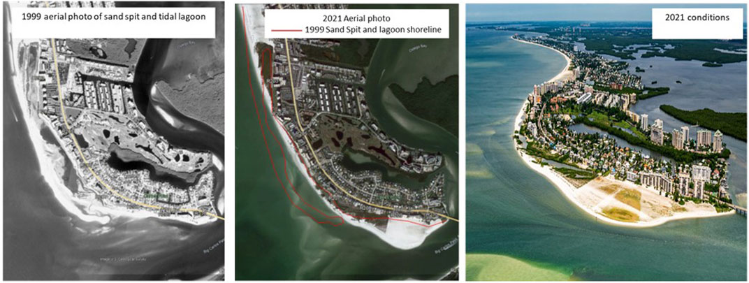
FIGURE 1. Evolution of sandspit at Big Carlos Pass, Southwest Florida.
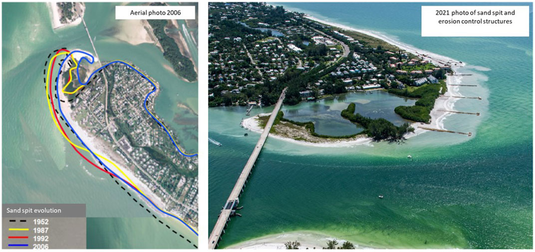
FIGURE 2. Evolution of sandspit and coastal management at Longboat Pass, Florida.
In this paper a case study aims at restoration of a sand spit and tidal lagoon system as an example of natural and nature-based solutions that sustain and enhance the natural environment and also maintain the protection from coastal storm flooding and sea level rise afforded by natural coastal systems. The project implements regional sediment management principles in the beneficial re-use of excess sediment removed from areas of accumulation and applied to areas of need.
1.2 Marco island case study
This case study, located along the north part of the Gulf of Mexico coastline of Marco Island, Florida, discusses a coastal restoration project that will restore and enhance a deteriorating coastal lagoon and sandspit that provide critical habitat and upland storm protection. The tidal wetland and large island/sand spit have provided vital environmental habitat for wildlife, coastal protection, and recreational benefits for over 2 decades. This case study demonstrates an alternative to typical coastal management practice of shore protection in areas of protected natural preserves. Typical coastal management in Florida, and the United States generally, would not intervene in designated natural preserves areas until erosion met a critical threshold threatening upland infrastructure. By that time, storm protective functions and valuable habitat will have been lost. Restoration of storm protective functions at this point often results in shoreline hardening and would not restore aquatic habitat similar to what would have been lost. The paper focuses on the technical approach demonstrating the concept of maintaining natural morphological features as sustainable coastal protection measures for both environmental habitat and upland development. The technical approach and management efforts in this case study are guided by environmental protection statutes and rules mandated by state and federal agencies in the US. Coastal management in the US in general and Florida in particular is generally more heavily constrained by environmental protection ahead of other issues.
1.3 Habitat description
The lagoon provides significant habitat for flora and fauna such as terrestrial wildlife, and submerged benthic communities such as seagrasses that support endangered manatees, and Essential Fish Habitat (EFH). This area is also designated as federal critical habitat for threatened species including piping plover and red knot shorebirds, as well as nesting and foraging habitat for state threatened species. A summary description of the habitat is provided here. Detailed data, maps and analysis of the ecosystem for Tigertail Lagoon and Sand Dollar Island are discussed in (Turrell, Hall and Associates 2021B).
As of summer 2021, the most recent data available, the island and lagoon system consisted of dry beach, mangrove estuaries, salt marsh, open water and aquatic habitats as summarized in Table 1 according to the Florida Land Use, Cover, and Forms Classification System (FDOT, 1999). There were 31 species of upland flora and 26 species of birds identified during surveys in 2021. There were 13 species of marine flora and 43 species of marine fauna identified in surveys from 2017 through 2021 including seagrasses, manatee, conch, crab, sponge, and a variety of fish. Loggerhead Sea Turtles nest on the Gulf facing beach, although the habitat is marginal and nest success is rare.
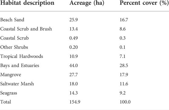
TABLE 1. Coastal habitats at Tigertail Lagoon.
Seagrasses represent a habitat type that is highly valued by US Federal and Florida regulations and policy. Seagrass habitats are generally valued for the diversity of species present and use throughout various life stages. Seagrasses also serve as a food source for the endangered West Indian Manatee, which commonly visit Tigertail Lagoon. Seagrass surveys were conducted in recent years and total acreage is provided in Table 2. The reach of seagrass within the lagoon has increased over time, extending into the narrow portion behind the Gulf fronting beaches. In this area, sand overwash regularly occurs, resulting in long term retreat on the order of 12–15 m per year along over 900 m of shoreline. This retreat continues to bury existing seagrass beds and eliminate potential recruitment areas. In the absence of intervention, the area will evolve to only landlocked marine seagrasses, representing a loss of available seagrass habitat and food sources available to marine fauna.
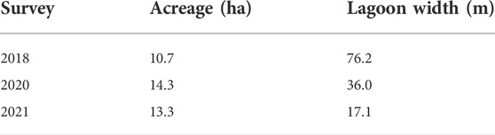
TABLE 2. Seagrass coverage and lagoon width.
1.4 Sand spit evolution
The lagoon system presently consists of a 3-km-long sand spit (Sand Dollar Island) sheltering a large tidal wetland and lagoon (Tigertail Lagoon) with salt marsh and interior mangrove shoreline areas that provide natural protection to the upland areas landward on Marco Island. Sand Dollar Island represents a front line of protection and resiliency to Sea Level Rise (SLR) and flooding that is rapidly deteriorating.
The lagoon system provides multi-tiered protection against coastal storms by wave height reduction on the sandy beach and limiting run-up and coastal flooding through the lagoon and mangrove systems. Monitoring data indicates onshore migration and degradation of these features over the past decade, especially following Hurricane Irma, a major Hurricane that landed on Marco Island in 2017. Irma reduced the height and resiliency of the central section of Sand Dollar Island resulting in high frequency storm wave and sand over wash into the lagoon. By the end of 2020 the degradation of the system became critical and the middle part of Sand Dollar Island was near attaching to the upland mangrove shoreline, which threatens to reduce the 3 km long tidal lagoon into smaller landlocked ponds and increase coastal vulnerability along the northwest part of Marco Island.
Figure 3 shows the location of the study area which extends from the central part of Marco Island’s Gulf coast to the northwest part of the island. The evolution of Tigertail Lagoon and Sand Dollar Island is part of the ongoing large scale natural tidal inlet evolution at the north end of Marco Island. Prior to the 1960s, Big Marco Pass was the main inlet between Marco Island and Sea Oat Island. In 1967 Capri Pass developed when Sea Oat Island was breached by natural processes. The breach on the up-drift side of Big Marco Pass created a dual inlet system that persisted for a few decades until Capri Pass became the main inlet for this system in the early 2000s.
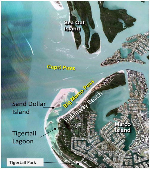
FIGURE 3. Sandspit and tidal Lagoon case study in Marco Island, Florida.
Figure 4 shows the inlet configuration in 1969, 2 years after Capri Pass was opened, and a comparison of more recent conditions represented by 2011 aerial photos with the 1965 shoreline before Capri Pass opened. The opening of Capri Pass created a dual inlet system of Capri Pass and Big Marco Pass separated by a small island (Coconut Island) and by a large and complex ebb shoal system (Dabees and Kraus, 2004).
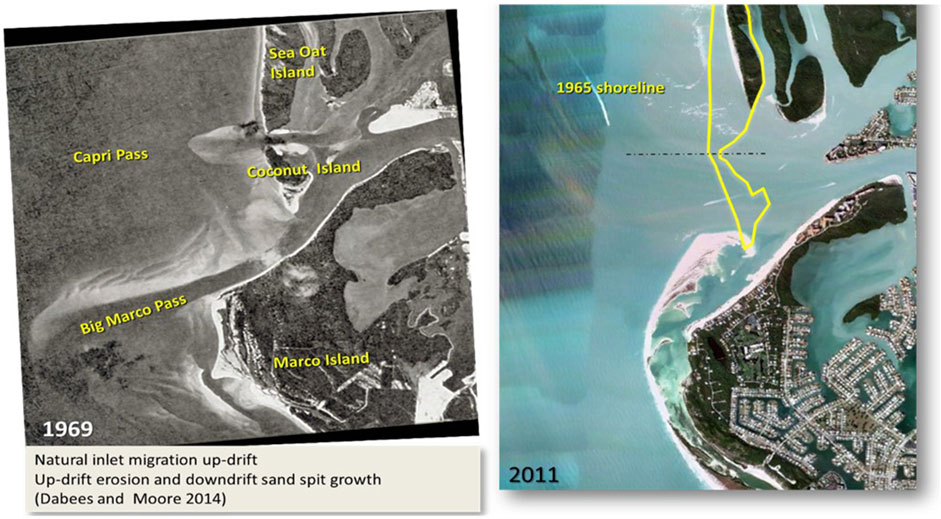
FIGURE 4. Comparison of the 1960s and existing conditions at the study area.
The reduction of tidal prism of Big Marco Pass resulted in onshore migration of its large ebb shoal rendering the pass more restrictive to tidal flow. The newer inlet became more dominant as it gradually captured a larger share of the tidal prism. This dual inlet process continued until the south inlet closed in the 2000s. Onshore movement of the ebb shoal at the closed inlet provides a large volume of sand to the down-drift beach (Marco Island) and formation of the active ebb shoal continues to the north. Formation of the new ebb shoal caused significant erosion on the north side of Capri Pass, along the south end of Sea Oat Island. The up-drift beach erosion is represented on the right side of Figure 4.
Sand Dollar Island formed as the relict Big Marco Pass ebb shoal gradually migrated toward Marco Island, eventually becoming emergent and attaching to the middle of Marco Island. This bypassing process from North to South was previously discussed by Humiston (1988) and is presumed to have shaped the present northwest coastline of Marco Island. Figure 5 shows the varying stages of Sand Dollar Island in decadal stages. First, Sand Dollar Island was a detached emergent shoal in the 1980s along the south side of the Big Marco Pass. The island then became a sand spit when the south end of it attached to Marco Island in the 1990s. During the 2000s Sand Dollar Island continued to migrate onshore causing Big Marco Pass to close completely. In the mid 2000s, the small island that separated Big Marco Pass from Capri Pass collapsed onshore and eventually welded with the north end of the Sand Dollar Island sand spit during the 2010s. The collapsing sand shoal, spit and lagoon system is consistent with typical inlet processes. In this case, management of the spit and lagoon system is planned to maintain the system as an open, functioning feature. This feature provides benefits in terms of storm damage mitigation and high value environmental habitat that would otherwise be lost, as illustrated in the other regional examples provided in this paper.
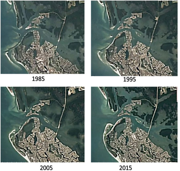
FIGURE 5. Decadal stages of Sand Dollar Island evolution.
1.5 Existing conditions and recent morphologic changes
Recent morphologic changes from 2010 to present (2021), indicate continued onshore migration of the sand spit at the northwest corner of Marco Island. Figure 6 illustrates the change in the sand spit shoreline from 2010 to 2018. The morphologic changes associated with the closure of Big Marco Pass include the shoaling and narrowing of Tigertail Lagoon, the water body between the Sand Dollar Island sand spit and Marco Island. In the absence of tidal currents from Big Marco Pass, waves dominating the coastal processes along the north end of Marco Island continue to transport sand from the westernmost point near the center of the sand spit towards the lateral ends of Sand Dollar Island (north and south). Along the south part of the island, sand is transported from north to south towards the attachment point south of the spit creating a very wide beach. On the north part of the sand spit sand is transported from south to north causing the growth and elongation of the sand spit. The sand spit growth and interaction with waves and currents push the north end of the sand spit towards Hideaway Beach. The sand spit attachment to Hideaway Beach, which would close off the opening of Tigertail Lagoon to the Gulf of Mexico, is managed by periodic dredging. This dredging keeps the lagoon open to tidal exchange when it would otherwise have become a closed system over a decade ago. Continued tidal exchange is essential to the water quality and ecology of the lagoon.
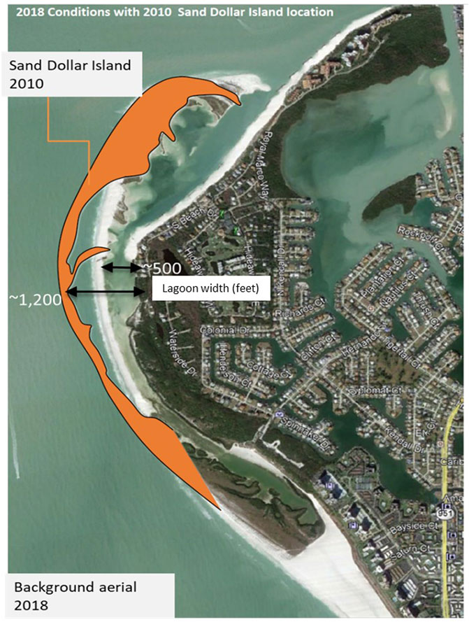
FIGURE 6. Recent shoreline changes of Sand Dollar Island.
1.6 Storm effects on sand spit evolution
In addition to the day-to-day coastal processes contributing to the elongation and onshore migration of Sand Dollar Island, storm events have significant influence on the sand spit evolution. Dabees (2018) discussed the effects of Hurricane Irma on Sand Dollar Island and are summarized here to illustrate the magnitude of change due to storm events.
Hurricane Irma was a major Hurricane in the 2017 tropical season that reached Category five and caused catastrophic damage in parts of the northeastern Caribbean and the Florida Keys. Irma made its landfall on Florida’s mainland on Marco Island south of Naples as a major Hurricane then tracked north along southwest Florida. The storm track and wind circulation influenced water levels and waves with high intensity and varying conditions over a relatively short time. The waves accompanied by the onshore storm surge phase added to the forcings affecting beaches, inlets and estuaries that make up the coastal system of southwest Florida.
Post storm observations and survey data collected pre and post storm along the study area of Sand Dollar Island highlighted the morphological response of the spit to the storm surge and waves. General trends included beach and dune erosion with significant sand overwash landward. Figure 7 shows an example of the morphologic response to Hurricane Irma on the lagoon and sand spit. The survey data and aerial photos indicated a landward migration of the sand spit of over 20 m and sand overwash on the lagoon side of the spit of over 30 m. The beach profile comparisons shown in the figure quantify the scale of the morphologic change in this area.
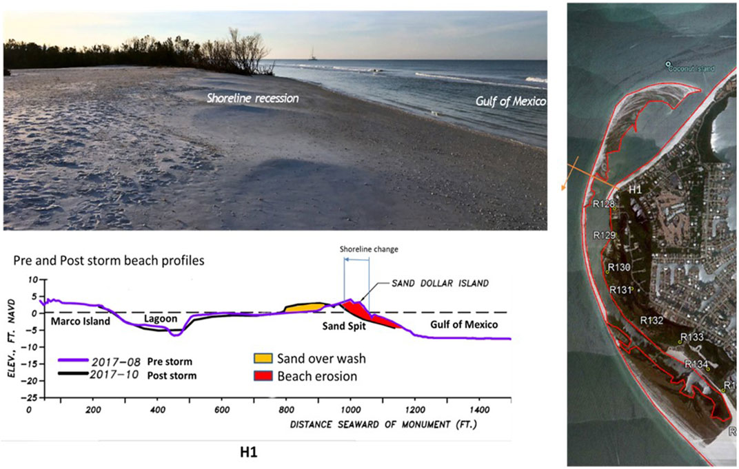
FIGURE 7. Morphologic response to hurricane Irma at a profile across the lagoon and sand spit.
Major storms impacting this area such as Hurricanes Wilma (2005) and Irma (2017) occur at approximately decadal frequency. When they occur, they cause significant morphologic response. In the case of Sand Dollar Island, the storms caused lowering of the beach elevations in the middle part of the sand spit leaving it more vulnerable to erosion and overwash during typical weather related storm events that may occur several times a year. For example, over the tropical season of 2020, two tropical storms passed offshore in the Gulf of Mexico, Cristóbal (June 2020) and Eta (November 2020). These two events generated mild storm surge and wave height but caused significant morphologic response at the middle section of Sand Dollar Island due to the low elevation of that section.
In summary, the ecosystem and its storm protection functions are severely threatened due to overwash and storm impacts especially since Hurricane Irma’s effects on Sand Dollar Island in 2017 (Dabees 2018). The Island has been migrating shoreward and its mid-section is low in elevation due to storm overwash, leaving a span of 1.5 km as an area of high vulnerability to storm damage. Environmental resources such as seagrasses within the lagoon have been systematically overwashed and covered with sand. In addition, littoral processes and inlet dynamics are eroding sand from this coastal frontline area towards the north end of the sandspit where shoaling is threatening to close off the lagoon entrance and only connection to Gulf tides. Figure 8 provides an illustration of the sediment transport processes including longshore sand transport and sand overwash which control the morphologic evolution of the sand spit. The figure also shows the morphologic response over the 2018 to 2021 period illustrating the collapse of the overwash area in the middle of the sand spit and the significant growth at the terminal north end of the sandspit.

FIGURE 8. Schematic of coastal processes and morphologic responses (2018–2021).
2 Nature based restoration plan
The nature-based restoration plan consists of reconstructing an elevated sand spit at its 2017 shoreline location to provide increased lagoon aquatic habitat, enhanced multi-tier shore protection against flooding and nature-based adaptation to sea level rise, improved tidal exchange and regional sediment management. Figure 9 provides an illustration of the restoration plan. The proposed Tigertail Lagoon/Sand Dollar Island Restoration Plan proposes to restore the vulnerable segment of this sand barrier with a more resilient beach berm by dredging areas of overwash from the lagoon side of the island and place that material along the Gulf side of the island, essentially to reset the Gulf shoreline to conditions in 2017 and restore lagoon acreage and tidal exchange.
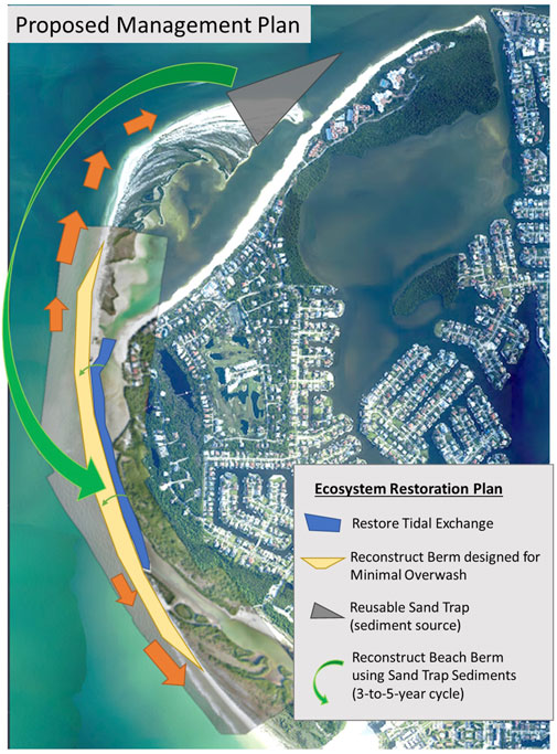
FIGURE 9. Schematic of nature-based restoration elements.
Elements of the restoration plan were assessed and optimized to avoid and minimize potential impacts to natural resources and also provide a sustainable design for future resiliency. The design elements were coordinated with local, state, and federal agencies that are stakeholders of this critical wildlife area and those in charge of permitting environmental and coastal projects.
2.1 Project design elements
The restoration plan is designed to establish adaptive management of the coastal system and nature-based adaptation to Sea Level Rise. Sand Dollar Island is located along the only segment of Marco Island that does not have a coastal management program in place. Retreat of the sandspit and loss of the tidal lagoon has reduced the coastal protection and resulted in deterioration of the critical environmental habitat within the lagoon system. Sand Dollar Island has been retreating at 12–15 m per year over the past decade, choking off the tidal exchange within the lagoon. The Florida Healthy Beaches program monitoring data has indicated increasingly frequent poor water quality events within the lagoon during the past 5 years. A summary of the design elements is described here, detailed engineering design and alternatives’ analysis are provided in the project technical reports (Humiston & Moore Engineers 2021B; Humiston & Moore Engineers 2021A).
The plan is focused primarily on reconstructing lagoon conditions and a protective sand spit. This morphologic restoration will allow for natural recruitment of flora and fauna as occurred prior to overwash and deterioration. The project will conserve and rehabilitate what remains of marine habitat and also restore other portions that have been overwashed. The enhanced beach berm will reduce the rate of overwash, allowing longer and more sustained recruitment and habitat compared to what occurred naturally. The plan will restore the Gulf shoreline and is estimated to maintain improved tidal exchange for four to 5 years post construction. The plan includes monitoring and management to support adaptive nature-based resiliency plans by recycling local sand sources from shoaling areas to the vulnerable areas within the system. The reconstructed beach will be situated at a higher elevation to reduce storm overwash and flooding by creating a broad sandy barrier on the gulf shoreline where minimal protection currently exists.
Numerical modeling and data analysis provided a basis to assess the function and resiliency of the proposed design. The restoration plan consists of three primary components that are necessary to the overall effectiveness of the plan but function essentially independent of one another. The three elements are:
1) Flow channel improvement,
2) Beach berm reconstruction, and
3) Renewable sediment source and sand trap.
Each element was analyzed independently to determine the preferred design for that element. The optimal design is the result of combining the preferred design elements.
2.1.1 Tidal Wetland Restoration: flow channel improvement
Sustainability of the system requires tidal flow supported by maintaining the lagoon entrance at the north end of the system. The entrance connects the lagoon to the Gulf tide, and a continuous channel is required to maintain adequate flow throughout the 3-km long lagoon. Design of an improved flow channel must balance the relative improvements from a given channel geometry with the presence of seagrasses in the vicinity. The improved flow channel should result in bathymetric conditions suitable for seagrass recruitment, but also be of sufficient size to be practical for construction and provide a reasonable design life between maintenance events. For example, a channel that is small and narrow will have the advantage of avoiding seagrasses and minimize potential impacts during construction but may not provide adequate dimensions to improve tidal circulation and be sustainable. A channel that is too small and narrow would have a limited capacity to accumulate sediment over time and maintain effectiveness, leading to poor performance and/or increased frequency of maintenance events. On the other hand, an overly large channel might be economically unfavorable, deliver diminishing returns, and could potentially impact seagrass beds. The location of the improved channel is a primary consideration. The channel has been designed and will be constructed such that it will not directly impact existing seagrass beds. This is accomplished by locating the channel within overwashed areas as much as practical, while avoiding any mapped seagrasses when working in water. This will return the overwashed areas to wetlands and create an improved flow channel to improve flushing throughout the lagoon. Several channel alternatives were evaluated through hydrodynamic modeling and assessment of flow throughout the lagoon and the environmental constraints for this Critical Wildlife Area. Hydrodynamic modeling of 2017 and 2020 conditions using the Coastal Modeling System (CMS, 2006) was used to simulate past, present, and design alterative conditions. The model was calibrated with field measurement from gages installed within the system and Gulf measured conditions. The model quantified the tidal flow throughout the lagoon and the change in flow over time as the central part of the lagoon became more restrictive. Several scenarios were considered for design. The final project design is presented in this paper for brevity. Engineering design followed typical coastal design methods using industry standard modeling packages and software.
Figure 10 shows example model results for one timestep during low tide. The model results indicate that conditions have deteriorated between 2017 and 2020, and in 2020 the lagoon becomes completely disconnected from the Gulf of Mexico at spring low tide which is consistent with field measurements and observation. The water levels for several tidal cycles were extracted from the model at the lagoon location and presented as a time series for all simulations in Figure 11. The water level from the Gulf of Mexico was added as a black dashed line for comparison. Tidal range envelope for the Gulf of Mexico, 2017, and 2020 conditions are overlaid with different colors to highlight the differences in tidal ranges. The figure illustrates the deterioration of conditions from 2017 to 2020 as shown in the tidal range decrease between the two survey dates. The water levels with the channel design illustrate an increased water level range when compared to both the 2017 and 2020 conditions. The increased range will improve flushing of the lagoon. The average tidal range was computed for all simulations and compared to the tidal range from the Gulf of Mexico. These ratios are presented at the bottom of the figure. The model indicates that the average Lagoon to Gulf tidal range ratio was 0.41 in 2017 and declined to 0.23 in 2020. The channel design would bring this ratio up to 0.76, indicating a larger tidal prism and improved flushing of the lagoon.
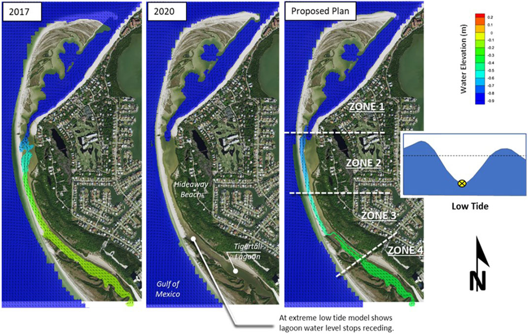
FIGURE 10. CMS model results at low tide for 2017, 2020 and design conditions.
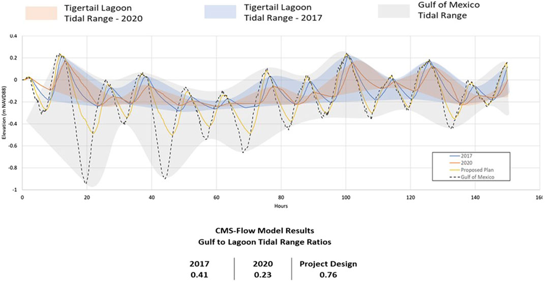
FIGURE 11. CMS model for 2017, 2020 and design conditions.
2.1.2 Sandspit Resiliency: beach berm design
The tidal lagoon system and seagrass habitats have evolved in the calm waters between Sand Dollar Island and Marco Island. The sandspit provides natural protection from incoming Gulf waves that break on the dynamic beach face, providing protection to the environmental resources and upland development. In addition to tidal flow enhancement needed to restore the lagoon, the viability of the system also requires maintaining the integrity of the sandspit (Sand Dollar Island) as a coastal barrier sheltering the lagoon and maintaining the entrance open. This section addresses stabilizing the mid-section of Sand Dollar Island where frequent overwash, since Hurricane Irma in 2017, is progressing towards closing the lagoon system. As such, restoration and resiliency of Sand Dollar Island is necessary to preserve the lagoon system. In the absence of the proposed restoration plan, the natural evolution of this sandy barrier will cause it to attach to Marco Island closing the middle part of the lagoon and preventing tidal exchange in the southern portion. The sandy beach would then continue to erode and then expose the existing mangroves to the Gulf of Mexico. Loss of the sandy beach at the northwest corner of Marco Island could then lead to erosion of adjacent beaches as the sand supply diminishes. This area would again be exposed to the open Gulf of Mexico as it was in the 1970s, but this time without the vast submerged inlet shoals that formerly supported Big Marco Pass and the adjacent shoreline.
In order to restore the lagoon area to 2017 (pre Hurricane Irma conditions), the reconstructed section of Sand Dollar Island will need to be a more resilient sandy barrier located seaward of the current position, returning the Gulf Mean High Water line to its late 2016 position. Reconstructing the beach berm provides an opportunity to reduce overwash and landward migration by elevating the berm to reduce the frequency of storm overtopping. Initial designs consisted of a conventional berm and dune profile which was modified after consultation with staff from Rookery Bay Aquatic Preserve. In response to their input, the beach berm is designed as a broad and relatively flat profile to provide the open spaces preferred by some shore bird species. The proposed beach slope is 1 V:15 H consistent with sea turtle protection standards. A nearshore berm is also proposed at approximately the Mean Low Water elevation to provide an intertidal flat and minimize escarpment formation during beach profile initial adjustments. Figure 12 shows typical cross section of the design flow channel and reconstructed beach berm.
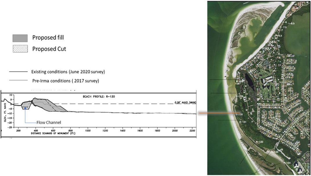
FIGURE 12. Flow channel and resilient beach berm design profile.
2.1.2.1 XBeach modeling for resiliency evaluation
The existing beach that is frequently overwashed has peak elevations less than 1 m above mean high-water level (MHW). Two alternatives were evaluated, one with berm elevations of +1.25 m and the other at +1.75 m above mean MHW. The engineered beaches at other segments of Marco Island Beach are constructed to elevation of approximately +1.5 m above MHW.
The XBeach morphology numerical model (Unesco-IHE et al., 2009) was used in the evaluation of beach berm resiliency design. The model was first set to simulate the morphologic change associated with Hurricane Irma to calibrate and test the model’s ability to simulate overwash processes associated with storms. Then, the model was used to evaluate alternatives under two different storm conditions.
The XBeach simulations were based on 2020 bathymetric and topographic surveys representing existing conditions and various design alternatives. The purpose of the simulations was to compare the performance of Sand Dollar Island during a high frequency storm and major storms with and without the restoration project alternatives. The XBeach model was set up to simulate the waves and the rising and receding water from the storm surge of a high frequency storm (less than 10-year return storm) such as Tropical Storm Eta (2020, surge: approx. +1 m) and from a lower frequency major storm such as Hurricane Irma (2017 surge: approx. +1.5 m) which is comparable to a 10-year return storm. Modeled berm conditions post storm impact were evaluated to determine the level of resiliency provided by each alternative.
Existing conditions
Figure 13 shows the simulation results for existing conditions (2020). Three-time steps were extracted from the model at T1 (initial condition), T2 (conditions at peak surge) and T3 (conditions at end of simulation). Each timestep is presented in the figure as a regional contour map. The maps are color coded as described in the figure for elevations ranging from 0 m to -2.5 m (-8.2 ft) NAVD88. The water surface is represented as a semitransparent blue overlay.
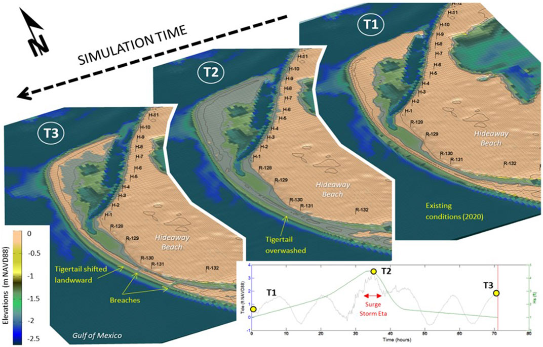
FIGURE 13. XBeach simulation of existing conditions under high frequency storm event.
At peak surge (T2), the model shows the water level (including waves) overtopping Sand Dollar Island. At that stage the berm has already started to shift landward (towards the east). At the end of the simulation (T3), the model results show the shifted shoreline. The lagoon channel is narrower than the initial conditions. The model also shows breaches through the berm connecting the Gulf of Mexico to the lagoon. Such breaches were documented during tropical storm Eta. Their exact location can vary and will typically follow areas along the berm with the lowest elevations. Because of the high sediment transport in the region and low tidal prism from the lagoon, these breaches tend to fill in with sand carried along the shore through wave action. Figure 14 presents the same model results extracted at four profiles along Tigertail for the existing conditions at left. For each profile, the initial conditions are shown as a dashed line and the final profile is indicated in blue with areas of erosion and shoaling shaded in blue and orange respectively. Profiles one through three show a landward shift of the berm, shoreline recession, and narrowing of the channel. Profile four falls in one of the areas which experienced breaching during the simulated storm, therefore the eroded profile is flat because the berm completely eroded.
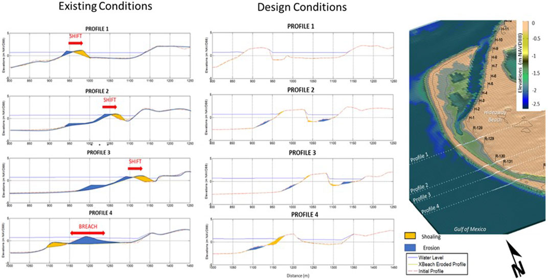
FIGURE 14. XBeach morphologic evolution under high frequency storm event.
Proposed design—minor storms
The same simulation was generated for the 2020 conditions with the proposed enhanced berm design alternatives. The enhanced beach berm included a wide elevated berm and mild sloped beach face that includes a submerged nearshore berm that further assists in wave energy dissipation and provides a milder profile that supports ecological needs in the area. Figure 14 shows the model results for the enhanced berm for the same four profiles at right. The cross sections show typical profile adjustment on the shore face without overwash or shoaling in the lagoon. The model also indicated the berm function in separating the lagoon water from the open gulf for that level storm. This functioning of the beach berm and enhanced profile effectively reduces shoaling with the lagoon from overwash and minimizes potential for suspended sediment settling in the lagoon under high frequency storms.
Overall, the model results show that the proposed berm design would enhance the resiliency of Sand Dollar Island to high frequency storms similar to the 2020 tropical storm Eta. The improved resiliency of Sand Dollar Island will help maintain the lagoon channel, tidal flushing, and water quality.
Proposed design—major storms
The second model test scenario examined the existing conditions and design alternatives under major storm conditions or a 10-year return storm such as 2017 Hurricane Irma. The model results show that for existing conditions under major Hurricane the sandspit would migrate landward with significant overwash filling in the lagoon, resulting in the barrier beach welding onshore in the center 1.5 km of the sandspit. For the elevated design berm, under a major Hurricane, the enhanced berm would prevent overwashing of the berm into the lagoon along the protected mid-section of Sand Dollar Island. The areas outside of the project area would still experience some level of overtopping at peak surge.
The optimal elevation and width of the design berm was selected at +1.75 m based on the results of simulations that showed resiliency for a 10-year return storm. A 10-year return design threshold is considered appropriate for the design life of this project and represents a significant improvement over the existing conditions. This selection is supported by the consideration that the model results represent initial conditions after construction and do not consider the compound effects of multiple storms and progressive longshore erosion over time. Monitoring and adaptive management allowing for maintenance at a manageable frequency of 4–5 years to restore the resilient berm to its design conditions would assist in maintaining the level of resiliency against major storms.
2.1.2.2 Proposed design—long term evolution
Volumetric change for the beach face at the retreating Gulf-facing beaches was determined using multiple survey datasets since 2001. This analysis requires isolating longshore and overwash components, which was done by subtracting overwash accumulation from the total change measured on the active beach face. These are provided in Table 3, along with annualized rates of change, and overall totals and rates. The data show an interesting trend of increasing rates of overwash, while longshore rates vary, likely in response to changes in curvature resulting from morphologic evolution. Longshore erosion rates have increased since 2009, which suggests that this is representative of the existing planform.
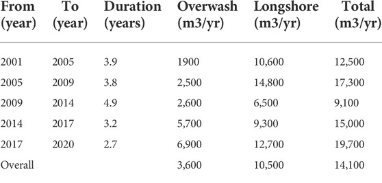
TABLE 3. Annualized volumetric change at eroding gulf beach face.
As shown by the X-Beach simulations, overwash will be eliminated for storms of less than 10% probability at the post-construction condition. However over time other factors such as rainfall, wind, storm conditions, etc are likely to reduce the overall berm height resulting in some degree of overwash. Likewise longshore transport may be anticipated to increase as wave energy that previously propagated over the berm will now break on the active beach face. Fill adjustment and re-establishing the curvature will also contribute to potentially higher longshore sediment transport than was previously observed. This suggests longshore erosion losses on the order of average (10,500 m3/yr) to recent observations (12,700 m3/yr), or higher should be anticipated. A reasonable engineering estimate of an average annual rate of 11,000 to 15,000 m3/yr is considered appropriate for long term estimates. Fill placement is estimated to be on the order of 300,000 m3. Project experience with coastal nourishment indicates that about half of the total fill will adjust cross-shore and laterally in the initial one to 2 years, suggesting 150,000 m3 will remain to provide protection. After 5 years approximately half (75,000 m3) of the protective volume can be expected to have eroded, which combined with reductions in berm height is likely to leave minimal protection and require maintenance. Storms of less than 10% probability may also decrease protective capability, indicating a 3–5 year nourishment cycle.
2.1.3 Lagoon Entrance Enhancement and Renewable Sand Source: Sand trap design
The integrity and viability of the lagoon is dependent on two main features, the sand barrier of Sand Dollar Island and tidal exchange with the Gulf through the maintained entrance at the north end of the system. The entrance at the north end has been maintained open through dredging in 2010, 2013, 2016, and 2019 to avoid closure and attachment of the north tip to Marco Island. However, each dredging event occurred at a different location to keep up with the growth of the sand spit toward the northeast. At present time further extension of the entrance in the northeast direction to maintain the entrance open is becoming unsustainable. This is due to the physical and hydrodynamic restriction as the spit further encroaches on Big Marco River where flow confluence will force attachment and closure of the entrance. On the other hand, the lagoon area and tidal prism have been in decline over the past decade mainly due to shoaling and overwash of the middle section of Sand Dollar Island. The reduction of lagoon area and potential collapse of the middle part of the lagoon will further reduce the tidal flow at the entrance forcing closure at the northeast beyond the current dredging program.
To address both features necessary to restore the system, a resilient berm at the midsection of Sand Dollar Island is needed as well as stabilization of the entrance to earlier, more stable conditions. Reconstruction of the beach berm at Sand Dollar Island will require a source of sediment in addition to sediment from the proposed flow channel. This source must also be available for future reconstruction events.
Sand Dollar Island has grown significantly during the past 2 decades. Establishing a Sand Trap to remove sediment from this area will provide a renewable sand source that will also benefit the management of the entrance to the lagoon by intercepting the sediment before it accumulates at the entrance. A sediment source for the berm reconstruction in this area will also return the sediment to an up-drift position where it will erode back toward the end of the island, creating a renewable cycle of regional sediment management. The renewable cycle will maintain the existing sediment cycle, which would otherwise deteriorate beginning with onshore attachment of Sand Dollar Island and accelerate when the erosion reaches the mangrove shoreline resulting in lack of sediment supply to the adjacent beaches.
3 Design plan
The final design is shown on Figure 15 and would consist of establishing a flow channel within the overwash and shoaled areas of the Tigertail Lagoon and to improve the resiliency of the Gulf-fronting shoreline of the sandspit (Sand Dollar Island) using sediment dredged from the flow channel and a sand trap at the north end of the sandspit. The design restores and enhances the protective function of the sandspit, the total wetland area, and will maintain sediment bypassing to adjacent beaches. All of these functions would be lost in the absence of the project.
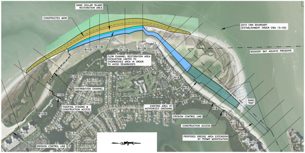
FIGURE 15. Final project design plan view.
The sandspit/tidal lagoon system in this case is a natural but altered system which has been maintained artificially by dredging the entrance at the north end of the sand spit on 3-year intervals since 2010. This allowed tidal flushing of the 3-km long lagoon to maintain water quality suitable for various wildlife resources and habitats. Water quality data collection was limited over the past few years. As part of the implementation of this project, a fixed data logger will be installed to record water levels and water quality measures near the south end of the lagoon to collect continuous water quality data to support analysis of project influence on water quality and environmental resources. A detailed biological monitoring plan was also prepared and approved by the permitting agencies to provide benchmark information and future monitoring of resources, physical and biological data that will from the basis for future maintenance and adaption requirements (Turrell, Hall and Associates 2021A).
4 Discussion
This paper focuses on the technical approach to implement the concept of maintaining natural morphological features as sustainable coastal protection measures for both environmental habitat and upland development. The technical approach and management efforts in this case study are guided by environmental protection statutes and rules mandated by state and federal agencies in the United States. Coastal management in the US in general and Florida in particular is regulated primarily for environmental protection ahead of other issues.
Barrier islands are dynamic, and the time scale of their evolution is longer than engineering project time scales. In this case Marco Island is a heavily developed barrier island, surrounded by multiple undeveloped/natural islands. Chronic erosion occurs due to the temporal intersection of upland coastal development and morphological evolution as the natural evolution changes the equilibrium planform relative to that at time of early development. Anthropogenic influences, including shoreline hardening, coastal structures and navigation dredging can also alter the equilibrium planform of barrier islands and associated morphologic features.
Integrating the objectives of the environmental preservation of natural resources and upland development coastal management objectives is a challenge. An incremental nature-based approach can start with preserving morphologic features that existed and functioned at time scales of years to decades. This approach would also allow for an adaptive management that is able to adjust in response to barrier island dynamics, influences and climate change and would be more sustainable than conventional methods of typical flood wall, barriers and hardened shorelines. In this case sustainability is established by the circular use of sediment from the terminal end of the sand spit that also allows for the lagoon entrance to remain open.
One of the important aspects of this case study is the intersection between an evolving coastal system bordered by a heavily developed barrier island. While the sand spit growth and on-going collapse is mainly caused by natural inlet evolution, in this case the anthropogenic influence has also factored in the presence and existence of the Tigertail Lagoon over the past 2 decades. The entrance to the lagoon has been kept open by artificial dredging on a 3-year cycle since 2010, thus allowing the 3 km long tidal lagoon to maintain wetland habitat with seagrass beds and interior mangrove shoreline. For such a quasi-natural systems to exist, management and maintenance is needed to restore and support the vitality of such system otherwise the erosion and retreat of the sand spit will continue until it reaches the upland development. In many instances upland developments do not qualify for hard shore protection or structural solutions unless meeting eligibility and vulnerability requirements. As such, areas that are subject to chronic erosion without active beach management efforts would eventually qualify for conventional shore protection measures in the future via various types of shoreline hardening or coastal structures.
This case study focuses on development of an adaptive management plan that supports the presence of a natural barrier system to coexist and provide coastal protection to a heavily developed barrier island. Coastal management including beach restoration and coastal structures cover most of the Gulf-front shorelines except the northwest part of the island designated as a Critical Wildlife Area. As such, the sandspit and lagoon area is designated as a Critical Wildlife Area managed by state and local environment agencies aimed at preservation of existing ecosystems and environmental resources. Because most of the current wildlife areas are typically managed to evolve naturally, those areas are sometimes not included in regional coastal management efforts. Preservation of such areas becomes unsustainable when chronic erosion gradually degrades a temporal coastal defense. As erosion progresses, those critical wildlife areas will be allowed to erode and migrate onshore until they intersect with upland developments. At that point of time, restoration of such features will not be possible and hardened shorelines or typical beach restoration would be the only available measure. These do not provide the multiple layers of protection provided by a system of sand spits, lagoons, and mangrove shoreline. However, timely restoration and adaptive measures at a manageable frequency can be implemented to maintain such system and this example showcases one of those cases where active management can integrate environmental conservation and shore protection efforts.
Among the challenges to this approach is to develop a plan that stratify environmental protection objectives and those with upland development for coastal and flood risk reduction. Often the objectives of upland development and protected preserve areas are not coordinated, and as a result are managed independent of each other. Coastal flooding resiliency efforts typically focus on reducing risks for flooding of infrastructure and protecting habitable structures under future SLR scenarios and increased intensity of storms.
On the other hand, environmental protection and preservation of ecosystems can be focused on protecting existing natural setting (natural preserves). Some aspects of that preservation are managed by designation of undeveloped ecosystems as natural preserves. When not maintained, the sand-spits and erosion progress until hard shore protection is necessary.
As such the main objective for this case is to restore and maintain the existing natural 3 km long sand spit as a coastal barrier and avoid its ongoing collapse. This will be followed by active monitoring and maintenance to preserve the ecosystem and natural and nature based coastal defense features.
5 Conclusion
The Tigertail Lagoon/Sand Dollar Island Ecosystem Restoration Plan has been designed to incorporate improvements to aquatic and upland habitat while preserving and enhancing the resiliency of the natural system. This Plan demonstrates the advantages of working with the natural environment and coastal processes to preserve and enhance existing habitat in a naturally evolving system. The project also provides nature based coastal resiliency to the environmentally sensitive area fronting upland communities. Establishing resiliency through nature based solutions such asmulti-tiered sandy barriers, coastal lagoons, and mangrove shorelines sets an example for future consideration elsewhere. Such examples are valuable for future planning as coastal cities and developed coastal areas are assessing future vulnerabilities to sea level rise and developing adaptation plans for improved coastal storm resiliency.
The intersection of natural evolution and upland development provided the unique conditions where a critical wildlife area had been created initially by natural evolution of inlet features and altered by limited frequent dredging which kept the tidal lagoon viable as wildlife habitat area. This ecosystem and its components are dependent on tidal lagoon environment. The frequent entrance dredging maintains the tidal exchange to the lagoon allowing seagrass to grow and mangrove shoreline habitat to persist on interior shorelines. The collapse of the middle section of the sand spit/and lagoon shoaling as well as the sand accumulation at the north end represented a physical detriment to the system. Expanding the dredging at the north end and using the sand to reinforce the vulnerable section of the spit provides an opportunity to restore and maintain the integrity of the sand spit and tidal lagoon as a coastal front. Its current presence and restoration provide a multitier coastal barrier system that maintains valuable natural resources and provide coastal protection to the upland. The conventional option of allowing the sandspit to collapse onshore then erosion to progress towards upland development will eventually lead to unnatural or hardened coastal front that will not allow for adaption to future barrier island dynamics nor sustain the environmental habitat value of the system that existed over the last 2 decades.
The design is based on working with nature to support the integrity and function of a natural barrier system that can adapt with changing sea levels while providing resiliency to storms. Sustainability and adaption are planned through monitoring and management plans to implement maintenance projects to elevate the sandy barrier and achieve desired resiliency coupled with cyclic use of sand within the system to maintain hydraulic viability of the tidal lagoon and address shoaling areas. Key elements in this plan also include integrated efforts with the upland community, the City of Marco Island, state and federal agencies, Rookery Bay National Estuarine Research Reserve and Critical Wildlife Area administration to maintain the integrity of a natural barriers system as an element to protect and manage coastal flooding vulnerability, wildlife habitat, and the City of Marco Island.
Data availability statement
The raw data supporting the conclusion of this article will be made available by the authors, without undue reservation.
Author contributions
MoD provided overall concept, design leadership, and manuscript preparation. MF and MaD provided technical analysis and documentation.
Funding
The work at Tigertail Lagoon/Sand Dollar Island is conducted by Humiston and Moore Engineers for the City of Marco Island funded by the Hideaway Beach Tax District.
Acknowledgments
The authors would like to thank the Hideaway Beach Tax District for supporting this work. The authors would also like to thank all stakeholders, professionals and permitting agencies who provided feedback and collaboration on the development of this nature-based restoration plan.
Conflict of interest
Authors MoD, MF and MaD were employed by Humiston & Moore Engineers.
Publisher’s note
All claims expressed in this article are solely those of the authors and do not necessarily represent those of their affiliated organizations, or those of the publisher, the editors and the reviewers. Any product that may be evaluated in this article, or claim that may be made by its manufacturer, is not guaranteed or endorsed by the publisher.
References
Chávez, V., Lithgow, D., Losada, M., and Silva, R. (2021). Coastal green infrastructure to mitigate coastal squeeze. J. Infrastruct. Preserv. Resil. 2, 7. doi:10.1186/s43065-021-00026-1
CMS-Coastal Modeling System (2006). Two-dimensional depth-averaged circulation model, U. S. Army Engineer Research and Development Center, Coastal and Hydraulics Laboratory, 3909 Halls Ferry Road, Vicksburg, MS 39180-6199.
Dabees, M. A. (2017). “Evolution of barrier island sand spits and effects on beach management practices. Case studies in central Florida gulf coast, USA,” in Proceedings of Coastal Dynamics 2017, Helsingor, Denmark, June 12–16, 2017.
Dabees, M. A. (2018). “Hurricane Irma’s morphologic response on beaches and tidal inlets in southwest Florida, USA,” in Proc. Of the 36th International Conference on Coastal Engineering, Baltimore, USA, July 30–August 3, 2018. http://www.eventscribe.com/2018/ASCE-36ICCE/assets/handouts/675702.pdf.
Dabees, M. A., and Kraus, N. C. (2004). Evaluation of ebb-tidal shoals as a sand source for beach nourishment: General methodology with reservoir model analysis. Proc. 17th National Conf. on Beach Preservation Technology, Tallahassee, FL, February, 2004, Tallahassee, FL: CD-ROM, FSBPA, 21 pp.
Dabees, M. A., and Kraus, N. (2008). “Cumulative effects of channel and ebb shoal dredging on inlet evolution in southwest Florida, USA,” in Proceedings of the 31st International Conference on Coastal Engineering, Hamburg, Germany, August 31–September 5, 2008 (World Scientific), 2303–2315. http://cirp.usace.army.mil/Downloads/PDF/dabees-kraus-ICCE08.pdf.
Dabees, M. A., and Moore, B. D. (2014). “Evaluation of beach erosion up-drift of tidal inlets in southwest and central Florida, USA,” in Proceedings of 34th Conference on Coastal Engineering, Seoul, Korea, 2014.
Dabees, M. (2020). Beach planform equilibrium, application and methodologies for climate change resiliency consideration. Int. Conf. Coast. Eng., (36v), 43. https://youtu.be/gWsbmi6VIo0. doi:10.9753/icce.v36v.management.43
FDOT-Florida Department of Transportation (1999). Florida Land use, cover and forms classification system. Handbook 92. https://www.fdot.gov/docs/default-source/geospatial/documentsandpubs/fluccmanual1999.pdf.
Humiston & Moore Engineers (2021A). Tigertail lagoon/sand dollar island ecosystem restoration project, alternatives’ analysis, technical report. Prepared for Hideaway Beach Tax District, City of Marco Island (43 p.) https://www.humistonandmoore.com/tigertaillagoon
Humiston & Moore Engineers (2021B). Tigertail lagoon/sand dollar island ecosystem restoration project, engineering management plan, technical report. Prepared for Hideaway Beach Tax District, City of Marco Island (132 p.) https://www.humistonandmoore.com/tigertaillagoon
Humiston, K. H. (1988). “The effects of the growth and migration of Big Marco pass ebb tidal shoal on Marco island beaches,” in Proceedings 1st National Conference on Beach Preservation Technology, Tallahassee, FL, March 23–25, 1988 (Florida Shore & Beach Preservation Association).
South Atlantic Coastal Study Main Report Final Draft (2021). South Atlantic coastal study main report final Draft. US Army Corps of Engineers. Washington, D.C., United States
Turrell, Hall & Associates (2021A). Tigertail lagoon/sand dollar island ecosystem restoration project, biological monitoring plan, technical report. Prepared for Florida Department of Environmental Protection. Tallahassee Florida. (33 p.) https://www.humistonandmoore.com/tigertaillagoon
Turrell, Hall & Associates (2021B). Tigertail lagoon/sand dollar island ecosystem restoration project, environmental management plan, technical report. Prepared for Hideaway Beach Tax District, City of Marco Island (270 p.) https://www.humistonandmoore.com/tigertaillagoon
Unesco-IHE, , , Deltares, , , and Tu, D. (2009). “XBeach model description and manual,”. Report Z4175. Available at: https://xbeach.readthedocs.io/en/latest/user_manual.html.
Keywords: coastal storm risk management, resiliency (environmental), sea level rise adaptation, barrier islands, inlet processes, geomorphology
Citation: Dabees MA, Fleming M and Damon M (2022) Natural and nature based features for environmental enhancement and coastal storm risk management: a case study on Marco Island, Florida, United States. Front. Built Environ. 8:884692. doi: 10.3389/fbuil.2022.884692
Received: 26 February 2022; Accepted: 05 July 2022;
Published: 29 August 2022.
Edited by:
Jane McKee Smith, Engineer Research and Development Center (ERDC), United StatesReviewed by:
Rodolfo Silva, Institute of Engineering, National Autonomous University of Mexico, MexicoPing Wang, University of South Florida, United States
Copyright © 2022 Dabees, Fleming and Damon. This is an open-access article distributed under the terms of the Creative Commons Attribution License (CC BY). The use, distribution or reproduction in other forums is permitted, provided the original author(s) and the copyright owner(s) are credited and that the original publication in this journal is cited, in accordance with accepted academic practice. No use, distribution or reproduction is permitted which does not comply with these terms.
*Correspondence: Mohamed A. Dabees, md@humistonandmoore.com