 Maj-Britt Quitzau
 Birgitte Hoffmann
- Department of Sustainability and Planning, Aalborg University, Copenhagen, Denmark
Tools applied by water professionals in climate adaptation projects tend to have a technical focus and a superficial stakeholder approach. Development of integrative and synergetic solutions require more delicate and transformative forms of stakeholder engagement. Through an action research process, this article explores how a visual canvas for stakeholder engagement can support water professionals in identifying, representing, and aligning stakeholders in development of integrative and synergetic climate adaptation solutions. The visual canvas is developed in the form of ‘Actor-Landscapes’, and presents a practical tool for engaging stakeholders inspired by Actor-Network Theory. Actor-Landscapes proved to especially support water professionals in four key challenges in their transformative approach to stakeholder engagement: 1) to recognize stakeholders more broadly and deeply, 2) to organize and present data about key stakeholders and the landscape in which these are anchored, 3) to prioritize which stakeholders to enhance based on alignment considerations, and 4) to legitimize mapped stakeholder perspectives through direct dialogue and engagement. The article concludes that Actor-Landscapes have interesting boundary object abilities supporting water professionals in inviting for and empowering integrative and synergetic transformations of knowledge between stakeholders in climate adaptation projects.
1 Introduction
In the European context, the flooding in July 2021 in parts of Germany, Belgium and the Netherlands reminded us once again of the critical impact of extreme climate events with loss of human lives and severely damage and destruction of important infrastructure assets (Koks et al., 2022). The increased occurrence of such extreme events (Seneviratne et al., 2021) call for state governments to increase attention to climate adaptation initiatives in spatial planning. Even in a country like Denmark, where floodings are less dramatic due to smaller river systems, the Danish State already in 2013 implemented a legal requirement for climate adaptation plans at the municipal level (Ministry of Environment of Denmark, 2013). Especially a severe cloud burst over Copenhagen in July 2011 with a total cost for the insurance business of 6 billion DKK set this governance initiative in motion (ibid). Denmark experiences 25% more precipitation during winter, and more intense cloudbursts during summer are expected to occur because of climate changes (Pedersen et al., 2020).
Technical expertise currently represents a core competence in approaches to climate adaptation in Denmark. This is reflected by the array of national models put at the disposal of water professionals in state guidelines: a climate atlas, a digital terrain model, a coastal atlas, and a coastal planner, as well as a national model for flooding from rivers and a hydrological information and prognosis system (Danish housing and planning authority 2022). For water professionals, technical models provide ways of mapping and using data to identify challenges and apply the best possible basis for assessing risks and foreseeing climate scenarios (ibid). Such models are recognized as critical elements to develop timely strategies both for predicting and mitigating the adverse consequences of climate change (Chavez et al., 2015).
However, this form of technical expertise is no longer sufficient in planning and local development processes (Lissandrello and Grin, 2011 in Munthe-Kaas and Hoffmann, 2017). Development of integrative approaches in climate adaptation require cross-disciplinary knowledge, cross-institutional collaboration, and multiple stakeholder approaches (Hoffmann et al., 2015). This integrative perspective is a result of the introduction of the concept of ‘Nature-Based Solutions’, which was presented in 2015 by the European Commission as multi-facetted solutions combining perspectives on nature, ecology, and urban development (Raymond et al., 2017; Frantzeskaki et al., 2022). The integrative approach implies that the traditional principle of channeling storm water away in invisible below-ground infrastructures is replaced with the principle of handling storm water on the surface as an active integration into attractive urban spaces (Jensen et al., 2016). This shift alters the perspective from solely considering aspects of risks and technical infrastructure to also encompass nature, human, and spatial aspects relating to synergy and integration with urban design and development (Hoffmann et al., 2015).
Stakeholder engagement represents a crucial part of developing integrative and synergetic climate adaptation projects. In the current practice within flood risk management, stakeholder representation and management is based on definitions and approaches developed and applied in business management (Reed et al., 2009). Here, a stakeholder analysis is understood as listing stakeholders and considering how their stakes impact the organization’s objectives (Freeman, 1984; Friedman and Miles, 2006). This way of defining stakeholder analysis resonates with Danish state guidelines recommending that stakeholders directly and indirectly affected by the plans should be involved in the planning (Ministry of Environment of Denmark, 2013). A key challenge with these prevailing stakeholder definitions and approaches is that stakeholders are reduced to a sort of a priory existing stakes (Metzger, 2013). This tends to produce solutions to a known problem, rather than providing “a new way of framing the situation and of developing unanticipated combinations of actions that are qualitatively different from the options on the table at the outset” (Innes and Booher, 1999:12). The latter is necessary to develop integrative and synergetic solutions, and hence, point towards the need for a different way to work with stakeholder engagement.
The need for a theory of stakeholder identification is advertised by Mitchell, Agle and Wood (1997:854) in order to “reliably separate stakeholders from nonstakeholders” by addressing who (or what) stakeholders are, and to whom (or what) to pay attention to. Such basic questions are especially intriguing when considering development of integrative and synergetic solutions, where a certain alignment of stakeholders and their values are implied. Successful development of such solutions involves a special “way of knowing”, where knowing is understood as a way to describe successful alignment of human and nonhuman elements (Bryson et al., 2009). The notion of alignments and this way of knowing refer to theoretical insights from Actor-Network Theory (ANT) about differentiating between whether actors transport objects and ideas, in the sense of merely withholding a status quo, or transform these through dynamics of re-alignments (Latour, 2005). Studying processes of change in planning, Innes and Booher (1999) similarly differentiates between discussions, where ideas and viewpoints are batted forth and back, and dialogues, where participants develop a pool of shared meaning, based on Senge (1990). In their point of view, dialogue represents a deeper way of knowing, which deals with inherent conflicts and help identifying solutions that offer mutual gains (Innes and Booher, 1999). Seen in this perspective, traditional stakeholder analysis is argued by Pineda and Johansen (2019) as a too static analytical tool without the ability to produce change and propose to find inspiration in ANT for a more relational and dynamic perspective due to its detailed accounts of how constitutional and relational dynamics of humans and nonhumans in processes of change.
Such a transformative perspective on stakeholder engagement require attention to how stakeholder analysis is approached to identify, represent, and align stakeholders in a productive way. The prevailing approach with listing of stakeholders and their stakes does not seem to appropriately support alignments towards integrative and synergetic solutions. Such an approach does not allow for collective tinkering and learning, which is necessary in transformative development processes, where the narrowness of focus among participants needs to be challenged, according to Innes and Booher (1999). Transfer of knowledge can be a treacherous endeavor, as indicated by Carlile (2002), who found that organizational functions structure knowledge differently, hereby creating challenges of transfer and transformation of knowledge across so-called ‘knowledge boundaries’. These considerations bring attention to the ability of stakeholder analysis approaches to act as boundary objects, understood as an object that is shared and shareable across different problem-solving contexts (Star, 1989).
The aim of this article is to explore how a visual canvas for stakeholder engagement can support water professionals in identifying, representing, and aligning stakeholders in development of integrative and synergetic climate adaptation solutions. The visual canvas is a result of a quasi-theoretical development of a practical tool for engaging stakeholders based on exploring the idea to represent stakeholders visually inspired by ANT and the desire to develop a more transformative and knowledge-crossing approach to stakeholder engagement. The theoretical and practical argumentation behind the choice of the visual canvas is outlined and expanded in the theoretical section. The visual canvas is developed in the form of ‘Actor-Landscapes’, which represent a practical tool for engaging stakeholders developed through an action research process explained in the methodological section. The analytical part outlines how these Actor-Landscapes have supported water professionals in four key challenges in their transformative approach to stakeholder engagement. The abilities of the developed visual canvas as a transformative boundary object is outlined in the discussion. The conclusion presents the main potentials for identifying, representing, and aligning stakeholders through Actor-Landscapes as a visual canvas.
2 Actor-worlds and their landscapes as quasi-theoretical starting point
The theoretical inspiration for developing and exploring Actor-Landscapes as a visual canvas is quasi-theoretical in the sense that the conceptual foundation draws on both practical and theoretical considerations. This is the result of an action research process, described in the methodological section, pursuing an integration between theory and action in order to develop a tool of practical use inspired by adopted theoretical insights. In that perspective, theoretical insights are mobilized and translated for practical use based on experiences gained during the action research.
The idea for developing a visual canvas for stakeholder engagement rose from a personal experience of one of the authors of this article while teaching about actor-networks to sustainable design engineering university students. When visualizing relevant human and nonhuman actors and their relations through ANT for a specific situation, the students tended to merely note headings of different groups of actors and draw lines between them to visualize relationships. This visual interpretation resulted in a too poor understanding of the relational dynamics within the visualized actor-networks. A similarly tendency for students to perform traditional stakeholder analysis when mapping actor-networks is also remarked by Pineda and Johansen (2019). The visualizations were challenged by asking the students to capture visually how different actor-worlds were represented and related. This proved especially rewarding due to the fact that these specific students have acquired drawing and visualization skills earlier in their education.
The concept of actor-world was first introduced by Callon (1986a) as a way to explain how Electricité de France constructed a specific actor-world around them based on a specific purpose and with all the ingredients determined by what was needed for the entire construction to work (or reach the purpose). Whereas Callon (ibid) mainly showed interest for an isolated actor-world, Jørgensen and Sørensen (1999) argued that such actor-worlds also interact and compete because different forms of problematizations prevail in concurrence. These actor-worlds represent certain narratives among different actors and each of them are continuously working on maintaining their position or reach a (new) equilibrium by convincing and assembling other actors around them (ibid). These narratives indicate some form of specialized way of thinking and acting prevailing within a specific actor-world, also reflecting how knowledge is embedded in specific practices, and explaining why practitioners are not so willing to change that knowledge (Carlile, 2002). Actor-worlds reflect a tacit knowledge and systemic logic that tend to imbue how certain actors (human or nonhuman) engage in developments of their surroundings, nourished by certain internal dynamics. The visualization in Figure 1 shows how one group of students in their interpretation of the actor-network identified five important actor-worlds (milk producer, packaging supplier, supermarket, private household, and municipality) for developing solutions for sorting milk cartons. Although the visualization, at first sight, put emphasis on traditional stakeholders, the visualization captures deeper layer of relational dynamics both in relation to specific actor-worlds, but also capturing dynamics of social ordering across these.
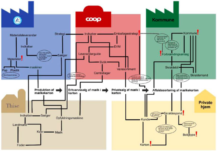
FIGURE 1. Illustration from sustainable design engineering students at Aalborg University visualizing actor-worlds based on the aim of developing solutions for waste sorting milk carton.
Using ANT to conceptualize stakeholders is markedly different compared to traditional stakeholder analysis. In the traditional understanding of stakeholders, a linear thinking prevails: 1) identify stakeholders, 2) manage stakeholders and 3) celebrate success (Pineda and Johansen, 2019). Although this represent somewhat of a caricature on stakeholder analysis, it underlines a significant difference to an ANT-inspired approach (ibid). Through mapping of actor-worlds and their relations, emphasis is shifted towards an understanding of the social order that prevails in the studied situation and how certain actors within this actor-network need to be convinced if the social order is to change (ibid). This illustrates the point of Bryson et al. (2009:173) that “strategic planning may ‘work’, but the question of whether and how it works, in what ways, for whom, when, and why is certainly open”. The linear way of thinking in traditional stakeholder analysis identify and represent important stakeholders well but fails to capture that multiple versions of translation take place in an actor-network, as actors continuously challenge and convince each other to change the status quo (in order to establish a new balance), and how this can be analyzed from different perspectives (Pouloudi et al., 2004).
It represents a crucial challenge for water professionals to know from what perspective to look at stakeholders within an actor-network. Creation of integrative and synergetic solutions require water professionals and stakeholders to engage in what Innes and Booher (1999) term as a kind of collective, speculative tinkering or bricolage. The term ‘bricolage’ is borrowed from Lévi-Strauss (1966) and differs from more familiar types of argumentation and tradeoffs by encouraging innovation and collective commitment through processes of learning and change among involved participants (Innes and Booher, 1999). Bricolage is relevant in this regard, because it helps to position water professionals in their difficult endeavor as spokespersons and translators for new climate adaptation solutions within a specific affected area. In that sense, water professionals are stakeholders too, battling on the same terms as the other stakeholders to push for certain agendas of change. They are spokespersons for the societal urgency to develop climate adaptation solutions, while still having to translate how such a solution should be designed to be able to break through and be implemented. The key point of bricolage is to understand that this battle does not take place in a vacuum (which the linear way of thinking seems to believe) but requires competences and hard strategic work to understand how a solution can be developed that other stakeholders will acknowledge and support.
It is characteristic for ANT to avoid reducing things to something else, but instead seek to meet these in their specific circumstances (Papazu and Winthereeik, 2021). An important practical circumstance of climate adaptation projects is that it will change a physical landscape, and this will affect the landscape itself and those that are somehow affiliated with it. As the characteristics of the landscape will also change, the changes may also shift who will have interests in it. An intriguing question is how a deeper understanding of such actor and landscape characteristics can be channeled into narratives for solutions to better reflect the problematization done by the water professionals and those affiliated with the affected landscape (either voluntarily by deliberately changing the landscape or involuntarily as a result of potential flooding). Through the format of Actor-Landscapes as a physical map, a visual canvas is provided that supports capturing the interpretation of social ordering through representation of how specific actor-worlds are affiliated with the affected area, including important characteristics and problematizations.
Physical maps represent landscapes in an object-form and are described by Harley (1987:1) as “fundamental tools helping the human mind make sense of its Universe at various scales”. The history of cartography indicates that there has probably always been, what Harley (ibid:1) terms as ‘a mapping impulse’, in the sense that human consciousness has cognitively mapped the physical space long before the physical artefacts of maps were first developed. Within geographical research it is also believed that we are all cartographers in our daily lives, as “(…) we use our bodies as the surveyor uses his instruments, to register a sensory input from multiple points of observation, which is then processed by our intelligence into an image which we carry around with us, like a map in our heads, wherever we go” (Ingold, 1993:155). Using physical maps as a canvas for visualization is interesting, because the graphical language of such maps enables communication about a place or space through a common language (Harley, 1987). Maps even have some legibility, since relationships among elements on a map leap to the eye, which is sometimes difficult to achieve in words (Gronim, 2001). Materials such as maps are also known in design games to provide a stage and tools to share current and past experiences as a way to envision future ones, as participants together can explore ways to bridge their differences and dependencies (Vaajakallio and Mattelmäkki, 2014). This resonates well with the need to establish dialogues across differences in viewpoints, as advertised by Innes and Booher (1999). The fact that maps are also recognizable across different knowledge boundaries also support physical maps as good boundary objects (Carlile, 2002).
Studies in social cartography are concerned with how to unfold the complexity of tensions and controversies through explorative mapping and representation (Venturini, 2010a). It contributes to an awareness about boundaries of complexity and simplicity in relation to mapping of social ordering: “The map is not the (observed) territory, neither should it be. (…). What would be the interest of such a method if it could just deliver a reproduction of the observed phenomena?” (Venturini, 2010b:797). A distinction in objectivity was developed by Latour (2008) in an effort to consider as much subjectivity as possible (in Venturini, 2010a) and forms part of the fundamental critique of the division between Society and Nature in social sciences that ANT challenges (Latour, 2005). A first-degree objectivity is the landscape itself (Venturini, 2010a) or the stage in a metaphorical sense (Stephan, 2015). This would be the physical landscape conveyed on the map, or direct stakes in terms of a traditional stakeholder perspective. The second-degree objectivity—on the other hand—is the experienced landscape or the whole of the machinery of a theatre (around the stage itself) (Venturini, 2010a). This distinction provides a theoretical distinguishment between superficial and in-depth interpretations of the landscape of actors and their tensions and controversies. Capturing second-degree objectivity helps to be attentive to all viewpoints and reveal the larger extent of actors’ disagreements (Venturini, 2010b). The intention with cartography is not to close controversies, but to increase the understanding of these and to show that different outcomes are possible (Venturini, 2010a). This resonates well with the need to differentiate different actor-worlds and better capture the interplay between these. A key challenge, which will be discussed later, however, lies in the difficulty of knowing how to, actually, observe and describe actor-worlds during the mapping process so that it enables good decisions about how to promote a desired state of stability or equilibrium.
3 Developing actor-landscapes through an action research methodology
Researchers and water professionals involved in ongoing climate adaptation projects have collaborated closely during this action research process. Multiple traditions within action research prevail, but its common core is a cyclical approach inspired by Lewin (1948) that integrates theory and action with the goal to address important organizational or societal issues together with those who experience them (Coghlan and Brydon-Miller, 2014). It involves creating new forms of understanding “since action without reflection and understanding is blind, just as theory without action is meaningless” (Reason and Bradbury, 2008:4).
This action research is anchored in a staging approach, which Dorland and Vinck (2022:3) describe as “a descendant of the Scandinavian tradition for action research from the 1960s and onward”. Characteristic of this approach is that it offers a strategic view on change through its combination of the action-oriented approach of participatory design and innovation with insights from Science and Technology Studies (STS) (Pedersen et al., 2021). Its emphasis on following and understanding alignment processes is well suited to the theoretical inclination towards ANT, as well as to the study of how water professionals stage and drive engagement processes to develop integrated solutions based on valuable synergies. In that sense, the researchers stage theoretical insight from ANT and other relevant theories, bringing these theoretical insights into practical reflections in real-life projects addressing the challenge of how to effectively create stakeholder alignments through the Actor-Landscape approach.
The relation between the researchers and water professionals was built up through the EU Life project ‘Coast to Coast Climate Change’ (C2CCC), a quadruple helix partnership led by the Central Denmark Region (C2CCC, 2022). The action research process was initiated as a masterclass organized by researchers as three workshops in 2020 and 2021 for water professionals from the C2CCC project looking for ways to work with value creation in climate adaptation projects. Interactions between researchers and practitioners helped to frame the conceptual idea of using a visual canvas, in the format of Actor-Landscapes, to support stakeholder engagement. The conceptual idea was further explored during an experimental phase mainly performed in 2021 and 2022 to better understand the potential of a visual canvas in identifying, representing, and aligning stakeholders. The water professionals involved saw a practical potential in the conceptual idea and were actively involved in the experimentation and development.
An overview of the four participating projects are outlined on Figure 2. The participating practitioners shifted from the masterclass to the experimental phase due to dependencies regarding timing and resources. The action research approach was also individualized to each of the four participating projects as shown in Table 1 in order to ensure anchoring and relevance of conducted experiments.
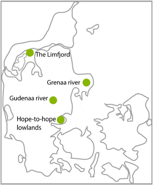
FIGURE 2. Overview of the four project areas in the Central Denmark Region represented by water professionals in the present action research study.
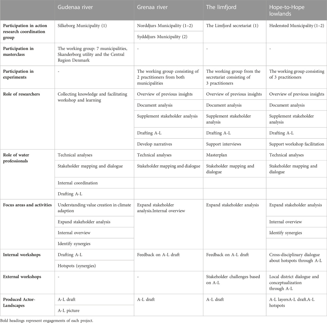
TABLE 1. Overview of the four projects in the action research to characterize the workflow and collaborative focus for each subproject. Please note that the action research process only actively engaged with parts of these projects for a limited period, and for that reason the table mainly outlines the project elements that were actively brought into the action research process. A-L is short for Actor-Landscape.
The Gudenaa river project is a project that involves the 7 municipalities that the river passes through. This project was mainly active in the masterclass process and is only elaborated in the first part of the analysis. An industrial PhD was financed after the masterclass and specifically followed up on this climate adaptation project with a different scientific scoping (for published results see, e.g., Jensen, 2023a; Jensen, 2023b). The Gudenaa river project was represented at coordination meetings with one representative.
The Grenaa river system is a project with starting point in a river that passes through Norddjurs Municipality and Syddjurs Municipality. Representatives from both municipalities became involved in the experimental part of the action research process with focus on internal forms of dialogues as well as feedback on propositions for ways of operationalizing Actor-Landscapes. This project was represented with 1-2 representatives for each municipality at coordination meetings.
The “Hope to Hope” project deals with a large low-lying area in Hedensted Municipality where climate adaptation solutions need to be developed. There is not the same inter-municipal coordination challenge in this project. The working group consisted of three water professionals and the experimental process involved both an internal and external workshop, where elements from Actor-Landscapes were tested. The project leader represented the working group at the coordination meeting often supplemented by 1-2 of the other representatives from the municipality.
The last participating project is that of the Limfjord, which is a large fjord in the northern part of Jutland. Although the C2CCC project has several projects in this region, it was representatives from the Limfjord secretariat who wanted to participate in the experimental part of the action research. The secretariat was involved in development of a masterplan for the Limfjord involving 18 municipalities in total. The main focus in this project was on supporting the external stakeholder dialogue through inspiration. This project was represented with 1 representative from the Limfjord secretariat at coordination meetings.
Common for all the four project areas was that water professionals were working on plans and solutions regarding climate adaption through active stakeholder engagement. The projects were in an initial phase of development with focus on collecting insights and initiating stakeholder analyses and dialogues. The water professionals actively sought to be part of the action research, and this reflects innovative thinking among the involved participants and positions the studied projects as “extreme” cases. The notion of extreme case is applied by Flyvbjerg (2006) about unusual cases that have potential to reveal more information than a typical case, because the deviant character activates more actors and dynamics in the studied situation. Even though it may not be possible to generalize all the gained knowledge, it still has potential to enter into the collective process of knowledge accumulation within its given field of research (ibid). Due to variations across projects and related experiments, this case is also multifaceted in terms of differences in contexts, planning situations and practices as well as goals for stakeholder engagement.
The researchers held coordination meetings as a way to allowed for discussions of the status and challenges of the project in order to time and align the action research initiatives. The projects had already gathered material about some stakeholders and had dialogues with them. Technical elements within the projects inhibited experimentation since some of the water professionals were reluctant to initiate stakeholder engagement until they had more clear technical insights and scenarios for the affected area. Although this was somewhat challenged by the researchers it was not always possible to push through with desired experiments. As a result, experiments with drafted Actor-Landscapes vary from internal feedback sessions with only involved water professionals to actual encounters with both other professionals from the municipalities as well as citizens and other stakeholders. The research initiatives were conducted by two senior researchers and two research assistants.
The cyclical approach of this action research has been achieved by changing between direct involvement, dialogue about experiences as well as withdrawal to develop, reflect and redevelop. This reflects the iterative form that many action research projects apply, as researchers make sure to both get involved in the empirical arena, but also withdraw to reflect about the findings and return with suggestions for change (Nielsen and Nielsen, 2010). The researchers used various resources to dig into each of the projects, involving literature search of local policy documents to compile the main themes, as well as a desk-research into digital maps to help expanding the understanding of the local area. This material has been compiled and provided the basis for developing suggestions for how Actor-Landscapes could look and which elements to contain to represent the collected material. These Actor-Landscape drafts were then shown to the involved water professionals and ideas for application and improvement of the Actor-Landscapes were discussed. Based on such inputs, the researchers withdrew to reflect and update the visual canvases as well as outlining ways of applying these in stakeholder engagement workshops. Most of the conducted workshops were facilitated by the water professionals themselves, based on materials provided by the researchers and based on an agreed consensus about the format. During the experimental process, researchers and water professionals were in continuous dialogue about experiences with Actor-Landscapes and further possibilities for development. Through the four coordination meetings, experiences of both researchers and water professionals were compiled and discussed.
The timeline of the action research process is shown in Figure 3. It shows how the cyclical process was arranged around four coordination meetings, where researchers and involved water professionals participated. Each of these meetings was prepared by the researchers with an outline of key questions to address together. The meetings had a workshop format that allowed the practitioners to share experiences and give feedback, and where the researchers could facilitate a reflective dialogue and present theoretical thoughts and insights of relevance. The researchers also met continuously with practitioners from each of the projects to agree on how the researchers could contribute to the ongoing processes. For each project different contributions were agreed, and actions were followed up in parallel workflows, as indicated by the grey boxes on Figure 3. Notes were also taken during these meetings. The researchers also actively participated in or facilitated specific workshops together with the water professionals and invited internal or external stakeholders.
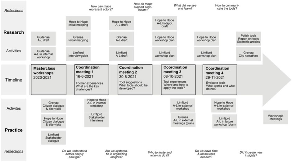
FIGURE 3. Timeline of the action research process from the masterclass to the final coordination meeting. The grey boxes indicate research and practice activities in the different projects. A-L is short for Actor-Landscapes. Questions in italics indicate typical reflections that researchers and practitioners typically brought to the collaboration.
During the entire process, the researchers have been writing down in a virtual whiteboard what their thoughts and suggestions were as well as their experience and insight from meetings with the professional practitioners and other stakeholders. This kind of autobiographical data is typical in action research, where part of the research documentation is the researcher’s roles, actions, and decisions (Herr and Anderson, 2005). The autobiographical data contains different drafts of Actor-Landscapes and internal brainstorms between the researchers about theoretical and practical considerations for choosing different formats. It has been a crucial part of the process to not develop one specific format for an Actor-Landscape. In all of the engagements with both the water professionals directly enrolled in the action research as well as internal and external collaborators that participated in workshops, the researchers have made active use of participant observation. This is a methodology, where the researcher takes part in the daily activities and interactions of a group of people as a means of learning explicit and tacit aspects of their routines and culture (DeWalt and DeWalt, 2011). For both water professionals as well as internal and external stakeholders this has involved indirect observations during meetings and workshops, where notes have been made about the experienced observations.
Data collection has also taken place in relation to gathering information about stakeholders in each of the projects. This has consisted of a mix of qualitative methods suited to the pace of the action research process. Research inputs for the projects needed to be delivered quicker than in a typical research project and this affected the choice and format of qualitative methods. For example, qualitative interviews were not conducted due to the number of resources needed to prepare, conduct, and treat information. Instead, informal dialogues and meetings represented the main source of information and insight. It has also been important for the researchers in terms of understanding external stakeholders that the approach could be replicated in the day-to-day practices of water professionals, and for that reason too scientific forms of data collection would have been too extensive.
4 Applying actor-landscapes in climate adaptation projects
The initial idea of Actor-Landscapes as a concept was developed at a masterclass workshop, where participants from the Gudenaa river subproject had a positive experience with visualizing actor-worlds within the river landscape. This positive experience was followed up with further development of the conceptual idea of Actor-Landscapes with emphasis on how to apply it to identify, represent and engage stakeholders. Through the action research process, the four key challenges depicted on Figure 4 were discovered that application of Actor-Landscapes helped to address.
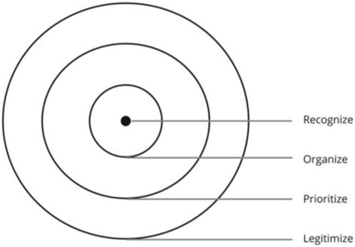
FIGURE 4. Illustration of four key challenges that Actor-Landscapes helped to address during the action research process.
Each of the four challenges represent different dimensions in the identification, representation and engagement of stakeholders that need to be systematically addressed. The inner part of the circles in Figure 4 represent internal work processes performed by the water professionals, while the outer part of the circles represent external engagement processes. In the following subsections, an analytical argumentation is given for the significance of each of these key challenges: recognizing, organizing, prioritizing, and legitimizing.
4.1 Recognizing actor-worlds and landscapes
During the masterclass workshop, the participants from the Gudenaa river project struggled, when they were given the assignment of visualizing relevant stakeholders. They had brought their collected material about stakeholders in the form of a large spreadsheet listing the different stakeholders and their main interests in the Gudenaa river project. The participants felt that the represented stakeholders within the list was sufficient and tried to discuss the visualization of stakeholders with starting point in the spreadsheet. The dead lock indicates that the water professionals were accustomed to identifying stakeholders through a traditional stakeholder approach, as outlined by Mitchell, Agle and Wood (1997), representing stakeholders through text in a spreadsheet. Such an approach was not in alignment with the researchers’ intention of gaining a deeper and more relational understanding of actor-worlds.
The researchers also struggled in the facilitation to convey the intention of mapping actor-worlds, due to difficulties providing the underlying theoretical considerations to the practitioners without theoretically overwhelming them. The intention of asking the water professionals to visualize the stakeholders was to enable the professionals to capture important relational dynamics, similarly to what the students did during ANT lessons. The researchers thought that such visualizations would encourage them to show an interest in mapping prevailing social orders in the actor-network, and hence, widen their actor-perspectives both in depth (characteristics of actor-worlds) and breadth (overlooked actors in the social order). Nevertheless, the assignment had a more abstract character for the water professionals—compared to the students—as they did neither have enough knowledge about the theoretical intentions nor visualization skills.
As an intuitive response to the lack of initiative to visualize stakeholders during the workshop facilitation, one of the researchers nudged the participants to start the visualization process by simply drawing up the river system on a flip chart and use that drawing as a canvas for thinking about relevant actors connected to the river itself and its surroundings. One person among the participants volunteered to take the pen and started drawing the river on the flip chart, as illustrated on Figure 5. This flipped the water professionals from thinking about actors as stakeholders in their climate adaptation project to think of actors as part of a landscape. Even though the water professionals did not know it, the visualization of the landscape lead them to adopt identification of stakeholders to mechanisms of social orderings. The visualization of the river helped the dialogue about identification and understanding of stakeholders on the way. The drawing was continuously developed alongside the dialogue with more details about relevant actors and notes about their relation to the river and its surroundings.
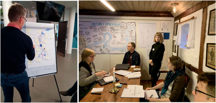
FIGURE 5. Actor-world mapping by the Gudenaa river working group. The left-side picture shows the working group drawing and discussing actor-worlds related to the river system at the masterclass workshop. The right-side picture shows the Actor-Landscape in use at a later working group meeting. The final graphical representation was developed by Miriam Jensen and Karen Rud Morthorst from Skanderborg Utility.
During the visualization process, the researchers observed how the visualization of the physical context of the river and its surroundings helped the water professionals to shift their stakeholder identification mindset. The water professionals developed a visualization that replicated a river landscape and identified stakeholders through their positions within this landscape. In that way, the water professionals approached an interpretation of actors and actor-worlds, as they began to reflect and make notes about important differences between the identified actors. They even began to identify important actor narratives by distinguishing between conflicts and potentials experienced by different actors. This shift in mindset underlines the importance of ‘recognizing’ as a first important key challenge which Actor-Landscapes help to address. It is important to remember that water professionals have established stakeholder analysis practices that need to be challenged in order to shift to a more relational way of identifying and understanding stakeholders. Experiences from the action research indicates that visualization of the landscape indirectly supports a re-positioning of the stakeholder identification process towards social orderings.
The visualization of the Gudenaa river landscape and its actors became the first draft of an Actor-Landscape in the action research process. After the masterclass workshop, the working group developed a more graphical representation of the Actor-Landscape with help from a graphic designer. It was produced on a large piece of paper and brought to following meetings within the working group, as shown in Figure 5. In a status report on the Gudenaa climate adaptation project for the C2CCC reporting, the Actor-Landscape is described as an ‘extended’ stakeholder mapping resulting in a visual representation of the ‘systems’ that the development of the project has to navigate in relation to (Jensen, 2020). It is further mentioned that the Actor-Landscape has helped to identify positive and negative values and is seen as a tool to open up for new solution and dialogue spaces in the development process (ibid). These mentions of the Actor-Landscape indicates that such visualizations—inspired by actor-worlds—can provide value and expand the traditional stakeholder analysis that water professionals usually conduct.
4.2 Organizing and presenting actor-worlds visually within a landscape
The positive experiences spurred both researchers and water professionals to engage in the further development and experimentation with Actor-Landscapes as a visual canvas for identifying and representing stakeholders in climate adaptation projects. Through initial dialogues with the water professionals participating in the experimental processes, the researchers learned that a lot of dispersed knowledge and insight about the local area and its actors was collected by the professionals as a result of initial activities in the projects and their former work. The water professionals seldom had an overview of their insight, and they struggled during initial meetings to leverage this material for identification and representation of stakeholders. As a result, the first part of the action research process became focused on gaining an overview of prevailing insight in order to create an internal stakeholder baseline by organizing available data about the local area and its actors.
The development of Actor-Landscapes was in this part driven mainly by the researchers, who collected prevailing data gathered by the water professionals and supplemented with further search of relevant data. The intention with this data collection was to explore what the level of details and nuances was in readily available data material in order to assess to what extent this could be applied to identify and represent stakeholders through the lens of actor-worlds. The data material from the water professionals represented insights from early dialogues, surveys, and field visits with external stakeholders that had been collected without being systematically organized and implemented in the ongoing development process. The researchers expanded the collected data with a broad digital actor and place analysis with main emphasis on the social and cultural domains, as the technical domain was already well represented through ongoing technical modelling and reporting. This data collection was done with an open and broad approach to not overlook any human or nonhuman actors relevant for social orderings. All the involved municipalities had digital maps that visualized relevant characteristics about each affected area. In some cases, this information was followed up by exploring digital maps outside of the municipal website and by making contact to GIS specialists within the municipalities for further insight. The researchers also followed up on documents and reports relevant for the affected area and the project. This involved documents such as the project description, summaries from steering group meetings, municipal and local plans as well as documents developed by local communities. The collected data was roughly coded to retrieve and categorize the data into appropriate themes reflecting essence in the data and visualized internally in virtual whiteboards as summarizing mind maps by the researchers.
The data collection does not reflect a typical methodological approach in ANT, as the researchers prioritized to explore and adopt how the practitioners would usually collect data within a climate adaptation project. This represents a pragmatic approach to data collection based on the acknowledgement that stakeholder analysis in practical reality involves limited resources, as noted by Mitchell, Agle and Wood (1997). From a research perspective it can be tempting to represent social orders as detailed as possible, but the water professionals very clearly stated at coordination meetings that limited resources was a pertaining issue for them. The intention with the representation of stakeholders was mainly to support the organization and overview of insight about actors and the landscape. This also reflects the acknowledgement that at this point in the process it is not clear what lens of social ordering to apply, since there are no clear development narratives in the project, other than the need for climate adaptation. In that sense, the depicted canvas of the landscape and its actors will have a generalized character mainly aimed at indicating potential actor-worlds somehow represented in available material about the affected area and the project. As will be shown in later subsections, Actor-Landscapes should not be considered as isolated and static representations but be continuously updated as part of an iterative process, where the stakeholder insight is adjusted, as the project trajectory becomes increasingly clarified.
The visualization of the collected data about the landscape itself mainly concerned reflections about how to capture and represent the characteristics of the landscape. Especially in the Hope-to-Hope project, different layout maps of the landscape of the low-lying area was explored, as illustrated in Figure 6. The desk-research had shown that many different formats prevailed in available GIS mapping. Often, the digital maps consisted of layers that could be turned on and off in order to make it possible to combine different forms of information in the same layout. Different techniques like choice of colors and icons were also applied to differentiate and nuance different details on the map. The detection of the complexities of mapping led to theoretical reflections about how to prioritize and choose what to enhance and leave out in the mapping. The researchers played with the thought of developing layers of information, but in the later stages of stakeholder involvement, this complexity was abandoned for fear that the visualization would become too ‘technical’ to understand and work with. As the maps in Figure 6 indicates there were some key elements important for the narrative of the Hope-to-Hope climate adaptation project that the researchers experimented on enhancing: terrain differences to indicate the placement and low-lying character of parts of the affected area, water due to its potential presence in risk of floodings, local cities and communities of a certain size to capture urban structures and concentration of human actors as well as differentiations between different land typologies (nature/settlement/farming) to capture general landscape characteristics. These landscape visualizations were mainly applied as background canvases for depicting actor-worlds.
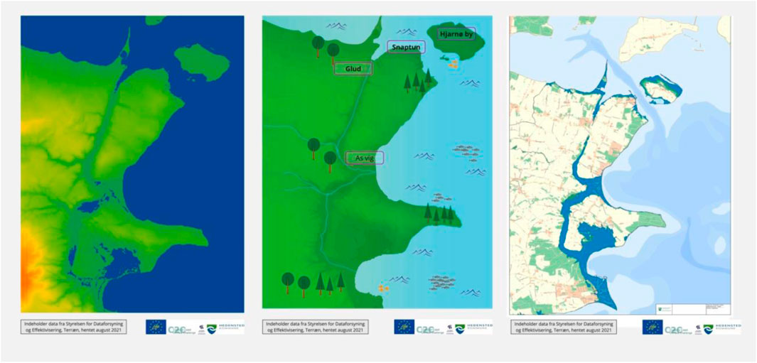
FIGURE 6. Simple physical maps of the Hope-to-hope project area to experiment with different formats of physical mapping. The left map is based on terrain differences, the middle map is based on depicting the low-land area and main nature elements and the right map is based on a more traditional map of the area including the low-land area in blue to indicate the risk of flooding.
The visualization of the collected data about actors involved reflections about how to capture characteristics of different actor-worlds and how to reflect relational dynamics through their position in the landscape. During the action research process, several different formats have been explored on how to visualize actor-worlds. Often, these formats were chosen strategically based on how Actor-Landscapes should be used. An example is that one of the Actor-Landscapes of the Limfjord project was developed on the basis of an abstract fjord landscape to avoid detailed disputes based on specific nested interests in the area. Sometimes Actor-Landscapes also mainly consisted of a background canvas because the intention was that external stakeholders should map actor-worlds themselves. The Actor-Landscapes were drafted within a virtual whiteboard, where background maps could easily be inserted. Sometimes ready-made maps were applied, and sometimes adjusted maps were developed through graphical applications on the basis of available maps. Information about actors and their characteristics were added to the background maps as icons, drawings, text, and post-it-notes. Examples of developed Actor-Landscapes from three of the projects are seen in Figure 7.
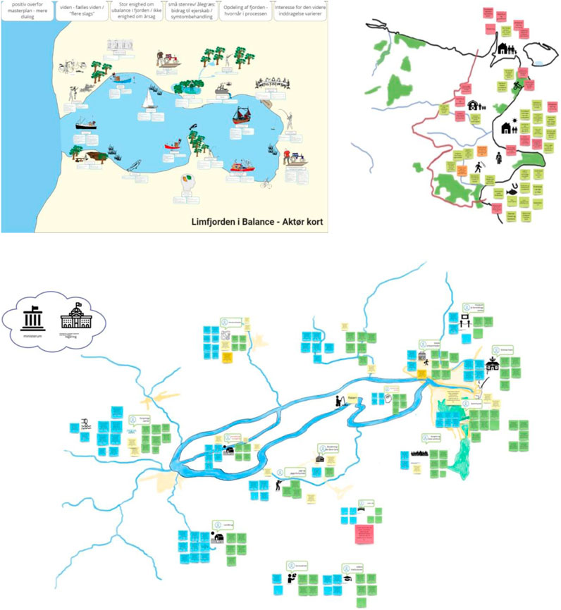
FIGURE 7. First drafts of Actor-Landscapes for Limfjorden (top left), Hope-to-Hope (top right) and Grenaa river (bottom). These are the original Actor-Landscapes presented at the first coordination meeting with the aim to capture some of the main insights about actors and landscapes from these three subprojects.
Common for an actor-world is that some similar traits or narrative typically bind the actor-world together, and hence, assign certain roles to that part of the actor-network, which differ to other parts. As shown in Figure 7, actor-worlds were mainly represented by visualizing specific actors and enhancing specific traits and characteristics. Although this is an oversimplification, attempts to provide more detailed representations resulted in negative feedback from the water professionals. The farmer in Figure 7 exemplifies the attempt to capture and visualize special actor-world characteristics. For example, the farmer is depicted as digging in the ground with a tractor at the side to provide connotations to the farmer as a person within the professional trade on cultivating the land. This helps to support the recognition that a key narrative for farmers is about proper conditions for producing foods. Some of the more detailed understandings of prerequisites are currently not captured on the visualizations, such as the fact that farmers might have requirements to the quality of the land, e.g., in terms of its humidity (avoid flooding) and access of either livestock or heavy farming equipment. Although only the farmer is depicted, the underlying connotations are that farmers are part of an actor-world, consisting of the farming land, the livestock, farming equipment, etc., and this is relevant for climate adaptation, because climate change might endanger either flooding their lands or propose solutions having an impact on food production.
The example with the farmers mainly make sense when we begin to depict other actor-worlds and become more aware of significant differences between these. An example of another important actor-world depicted on Figure 7 is, e.g., fishermen, who are visualized either as fishing boats (professional fishing) or as a person fishing (recreational fishing) and with affiliation to water itself (either fjord, river or sea depending on the context). The illustrations of fishermen represent an entirely different narrative of the actor-world of fishing, compared to farming. In relation to fishing, the main point of interest are fish or mussels in the water, and the equipment used for catching these are completely different from those applied in farming. Novels in ANT might question whether such level of detail is necessary, but as the scallop-narrative of Callon (1986b) illustrated so well, the tiniest of actors (like scallops attaching to a rope) might have great importance for the lack of success of the intended change process (the end of fishing scallops within a specific bay). Such detailing also allow to uncover important details about actor-worlds, e.g., that fishing prevails in different forms—some are individuals that fish for recreational purposes, while others have fishing as a profession. Fishing can also be done through different means in terms of equipment. Such details may impact how actors position themselves in threatening landscape changes, and it also provide room for understanding that divergent narratives are present, thereby avoiding that actors become trapped in their own thoughts and fail to see other assumptions and possibilities, as argued by Innes and Booher (1999). As an idiom says: “the devil is in the details”.
In hindsight, it can be difficult on the Actor-Landscapes to embrace the more fully actor-worlds—as depicted on Figure 1 developed by the students—as the complexity of actor-worlds are downplayed in Actor-Landscapes to simple icons of actors. The action research process, however, indicated that these visualizations carry more insight for the water professionals than the simple icons. In that sense, Actor-Landscapes as static visualizations would be ineffective, as the effectiveness of the approach lies in its facilitative ability to harness in-depth and broadened insight about actor-worlds as well as organizing and presenting this insight in a simplified overview. An Actor-Landscape does not provide a 1-1 representation of the real-life world, but it has potential as a visual canvas helping water professionals to organize stakeholder insights by indicating current states of stakeholder insight. The second-order objectivities—in terms of representations of actor-worlds—are captured through a continuous and iterative data collection based on the underlying principle of gaining a more detailed understanding of prevailing actor-worlds.
At the first coordination meeting, the drafted Actor-Landscapes in Figure 7 were included as part of the status of the projects. The water professionals found potential in the idea of understanding the actors at a deeper level, as this could help to better understand experienced tensions and conflicts experienced in development processes. The water professionals also saw potential in widening their stakeholder scope from the more traditional interest groups to broader stakeholder perspectives, which they generally found difficult. They saw potential in the Actor-Landscape as a way to increase their awareness about other actors and were curious if the approach could help to shape more active and broader involvement of actors. During the more direct dialogue with each project, it was clear that diverging concerns and needs prevailed regarding the format of Actor-Landscapes. In the Grenaa river project, not all of the water professionals felt that the Actor-Landscape captured the context and situation well enough, and this created reluctance towards applying the Actor-Landscape outside of the working group. In the Limfjord and Hope-to-Hope projects, the Actor-Landscapes were positively received as a good way to represent insight about actors and landscapes. In both of these projects, further experience with application of the Actor-Landscapes together with internal and external stakeholders were gained.
4.3 Prioritizing actor-worlds and landscape perspectives
Working with developments of several Actor-Landscapes in the initial part of the action research indicated prioritization challenges in terms of which actor-worlds to enhance in an overwhelming amount of data about both the project itself and the affected area. This included the aforementioned balancing act between the intention to capture actor-worlds well and the practical limitations of the water professionals. However, it also included an intrinsic relation between definition of actor-worlds and trajectories in development narratives. This implies a ‘catch-22’ situation with mutually depending conditions (Heller, 1961), where trajectories for development narratives cannot be created (in a proper way) without understanding actor-worlds, but on the other hand, actor-worlds cannot be defined without having created trajectories for development narratives. Such tensions are seldom revealed in what Vikkelsø (2007) terms as classic retrospective ANT analysis, where descriptions and understandings are based on studying accomplished processes of change with a known outcome. This aspect is crucial to address in the studied climate adaptation projects due to the ambition to develop integrative and synergetic solutions.
In the preparation of an internal stakeholder engagement process in the Hope-to-Hope project, the researchers presented the concept of hotspots in Actor-Landscapes as a way to introduce an element of prioritization. A hotspot was understood as indications of underlying synergies or overlap between characteristics or narratives and relates to the idea in ANT to build momentum towards change through processes of alignments (Latour, 2005). This element of prioritization was embedded in stakeholder engagement processes as a way to interest and enroll relevant actors in the development process. The stakeholder engagement first initiated through an internal format in the municipality in the Hope-to-Hope project based on the experience of the researchers that professionals from other municipal departments could contribute with valuable insight that eventually would enhance a broader engagement (see, e.g., Quitzau et al., 2022). Through this internal dialogue, other disciplinary perspectives were invited into the development process as a way to identify potential synergies with other municipal development projects in the affected area.
The project leader in the Hope-to-Hope project invited relevant colleagues to a workshop. The intention was to include colleagues from the social and cultural domains to gain insight from these perspectives as well. Not surprisingly, it turned out to be difficult to attract colleagues outside of the technical administration to a workshop about climate adaptation, which are considered a technical task, so invited stakeholders mainly included project managers from other technical projects in the municipality operating in parts of the affected area. Nevertheless, the internal workshop provided an interdisciplinary environment, where experiences with prioritizations through Actor-Landscapes could be gained. An important part of the workshop was to create a stage in which the participants could learn to understand each other in terms of the represented disciplines and that underlying development narratives were clear, so that synergies could more easily be uncovered through the dialogue. In order to do this—and warm up for actively applying visualizations—the participants were asked to draw themselves and their current project on a blank piece of paper as part of the introduction round. In the following assignment, the participants were asked to map challenges and actors for each of their projects in smaller groups on a simple background representation of an Actor-Landscape. One of the groups only used text notes, while the two other groups applied both drawings and texts. The dialogues were then shared, and the Actor-Landscapes further developed.
The prioritization dialogue took starting point in asking the participants to identify potential hotspots based on their previous dialogue and mapping. This led to encirclement of three main areas on a common Actor-Landscape. These areas were encircled because of different potentials for synergetic developments between the projects. E.g., the northern circle took its starting point in a strong local community with several educational institutions and tourism but with local settlement challenges and focused on Natura 2000 projects in the area that could be combined. In the evaluation of the workshop, the water professionals said that they experienced that the workshop had established a strong energy for working across the different focus areas and found that new potentials for synergies were discovered through the workshop. In that way, the dialogue both widened the horizon to inclusion of new development perspectives and created commitment across project managers in the municipality. The process also more specifically led to prioritization of some local areas to investigate and focus on. Examples of the illustrations and outcomes of the dialogues is shown in Figure 8.
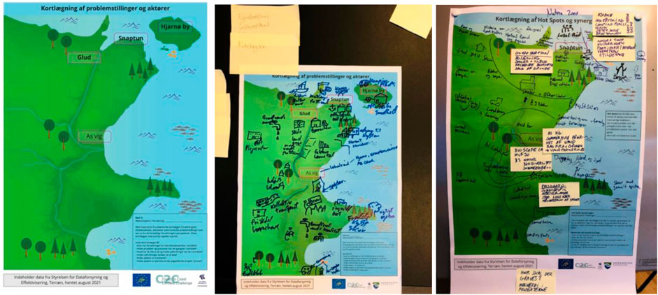
FIGURE 8. Original Actor-Landscapes from the internal workshop in the Hope-to-Hope project. The left side shows the initial illustration given to the participants, the middle shows the result of one of the group discussions and the right side shows the result of discussing synergies by identifying hotspots on a common Actor-Landscape.
After having identified hotspots, the participants finished the workshop by identifying important actors and landscape elements in relation to each of the three hotspots. After the workshop, the hand-written Actor-Landscapes were cleaned up on a graphical representation that summarized the main conclusions and reflected the prioritization at the workshop. Additionally, four down-scaled Actor-Landscapes were produced for each hotspot (a fourth was decided afterwards). The intention with these Actor-Landscapes was to explore the iterative work of identifying and representing stakeholders. Whereas the first Actor-Landscapes (in the former section) were developed for the entire low-lying area, these new Actor-Landscapes now zoomed more specifically in on specific local communities in the affected area, where potential for synergy had been identified. The researchers repeated the desk research from the beginning of the action research but with more specific focus on gathering insight about the northern area in the Snaptun and Glud hotspot, where a follow-up workshop was agreed to be held. This collected data was summarized in Actor-Landscapes of this hotspot as shown in Figure 9.
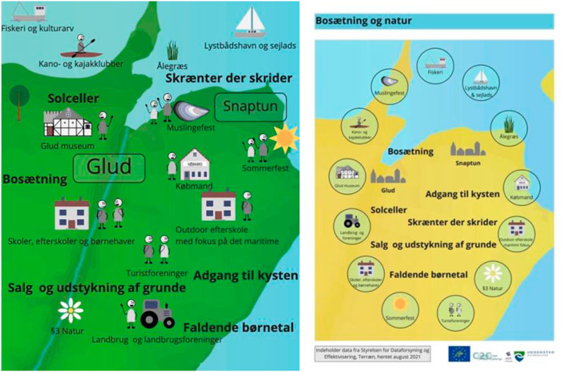
FIGURE 9. Original illustrations of Actor-Landscapes of the Snaptun and Glud hotspot with presentation of key insights from the internal workshop and the supplementary desk research. The left side represent mainly actors and landscape elements, while the right side represent more general themes that were raised. It illustrates different ways of organizing the data.
The experiences with prioritization through Actor-Landscapes showed that the visual format was both well-suited and created a positive momentum towards collaboration, as well as introducing leverage to identify areas of synergy to follow-up on. During the internal workshop both drawings and visual texts helped to accentuate characteristics of different perspectives, and this was then used to point out where there were synergetic concentrations. In the workshop in the Hope-to-Hope project, the hotspots were identified on the basis of geographical areas, but in principle it could also take form as, for example, synergy between themes or characteristics in actor-worlds. The experience from the prioritization was also that it acted as a good starting point for gaining new perspectives and follow-up on collecting data about relevant actor-worlds. This process is—again—rather pragmatic, and it is off course important to note that synergies are developed on the basis of who are invited to the table. In this regard, a broader representation of municipal disciplines would have been beneficial to include better emphasis on social and cultural dimension, which are often overlooked.
4.4 Legitimizing actor-worlds and landscape perspectives
The final key challenge to present is that of legitimizing actor-worlds and landscape perspectives. This challenge was crucial for ensuring a local commitment and engagement in the process. In the end, the water professionals intend to create added value for the local stakeholders, so these alignment processes would only be successful if the local stakeholders can actually concur with the created values. Generally, in planning theory, the lack of appropriate and timely involvement of citizens represent a widespread critique of prevailing planning practices (Hoffmann and Munthe-Kaas, 2020). Seen in this perspective, Actor-Landscapes should not be developed in isolation from relevant external stakeholders, but on the contrary, be developed together with them to ensure legible interpretations of prevailing actor-worlds as well as legible prioritizations of development narratives.
Based on the internal workshop in the Hope-to-Hope project it was agreed that the Snaptun and Glud hotspot would be a suitable area for exploring how Actor-Landscapes could be applied in a dialogue process with local stakeholders. Within the Municipality of Hedensted, the local communities are organized in district councils. Such councils were perceived by the water professionals as a good entry point for external stakeholder dialogue about climate adaptation. An external workshop with the district council in Snaptun in the Northern part of Hedensted Municipality was arranged. Although the former Actor-Landscapes had been developed for this area (see Figure 9), the water professionals and the planners agreed that it would be best to let the participants at the workshop provide insight into their own actor-worlds. The already developed Actor-Landscapes still formed part of the preparatory work and as background knowledge.
The time frame of the workshop with the district council was set to 2 h. This was deemed appropriate to ensure a good dialogue, while also keeping in mind the limited resources of both the water professionals and the participants from the district council. The chosen Actor-Landscape canvas for the workshop was two more traditional maps of the local area—one from a satellite view and one from a settlement view. These formats were chosen to represent the landscape of the area, because it was agreed to include a small walk within the area as a way to truly capture how these local actors experienced their local area. In the first part of the workshop, the participants from the district council were asked to outline prevailing issues in the area. They were asked to both map important landscape elements, as well as perceived potentials and challenges within the local area. After that, they were asked to outline a walking route for a 30 min Walk to show us the most important aspects from their mapping. During the walk in the local area, there was a continuous dialogue about the area. Notes were written on the way and pictures were taken to capture the impressions. A polaroid camera was used to instantly print the pictures for use in the second part of the workshop.
In the second part of the workshop, the dialogue was directed towards identifying themes for future development that could be linked to the climate adaptation project. This dialogue was based on the previous mapping and some inspirational pictures outlining general themes for inspiration. The dialogue led to yet another four local hotspots that the participants identified as thematic focus areas for local development. The researchers produced a collage that summarized each of these as conceptual proposals for local development. The collage identified each of the chosen local areas and gave impressions of it through the polaroid pictures, and also included the chosen inspirational pictures that the participants had related to the theme as well as summarizing texts and headings. Impressions from the working process and an example of one of the collages is shown in Figure 10.
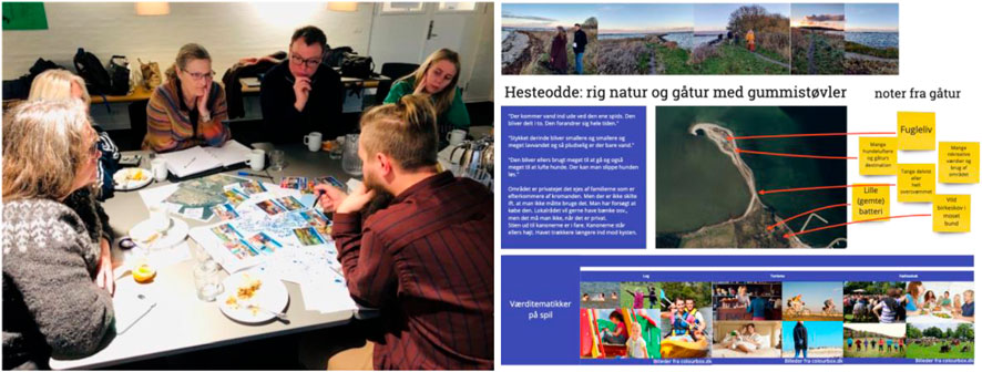
FIGURE 10. Dialogue about the local area through maps and inspirational pictures (left) and capture of main characteristics in relation to one of the identified hotspots after the workshop (right).
Similar to the internal workshop, the project leader from the Hope-to-Hope project also experienced a positive energy in the external workshop and felt that there was a good sense of commitment and engagement at the end of the workshop. It was also agreed to follow up with further dialogues to pursue some of the current ideas, and the participants claimed interest in engaging in the climate adaptation project and invited also to a broader citizen dialogue in the area in this regard. In the preparation of this workshop, it was chosen not to let the participants directly legitimize the internally developed Actor-Landscapes, as it was deemed more appropriate to allow the actors to describe their actor-worlds themselves. Although the participants were not directly asked to map actor-worlds, the intention behind each of the assignments were to gain further insight into relevant actor-worlds in the local area. The walk in the area was chosen to give added leverage to legibility in terms of actually having the participants show the landscape and point out relevant actors. This workshop was more directly oriented towards stakeholder engagement in the sense of identify important development narratives for the area that the climate adaptation project could potentially address. The workshop provided interesting material for further follow-up, although this marked the end of the action research process.
5 Discussing potentials and limits of actor-landscapes as boundary objects
Attaining integrative climate adaptation projects with valuable synergies require collaboration across disciplines and through multiple stakeholder engagement, because trade-offs between different competing interests and services prevail and must be bridged in urban and rural areas to develop viable solutions (Ellis, Pascual, and Mertz, 2019; Tubridy, 2020). This requires a special form of consensus building, according to Innes and Booher (1999), dealing with inherent conflicts and identifying solutions that offer mutual gain. In the following discussion, the effectiveness of Actor-Landscape as a visual canvas for stakeholder engagement is assessed as a boundary object as well as accounting for the difficult balancing act between developing a second-degree objectivity analysis through a first-degree objectivity visualization.
An object does not become a boundary object unless it functions as a boundary object. This occurs, when objects “have different meanings in different social worlds but their structure is common enough to more than one world to make them recognizable, a means of translation” (Star and Griesemer, 1989). The effectiveness of a boundary object is based on three characteristics according to Carlile (2002): 1) establishment of a shared syntax or language for individuals to represent their knowledge, 2) provision of concrete means to specify and learn about individual differences and dependencies, and 3) facilitation of a process where individuals can jointly transform their knowledge.
Establishment of a shared language to represent individual knowledge was done through the simplified way of representing characteristic landscape elements and actor-worlds on a visual canvas. An Actor-Landscape is not intended to function as a traditional map merely outlining the recognizable landmarks of a spatial area. It intends to convey analytical insight through codified and visual interpretation of characteristics, relations, concerns, and potentials of an area affected by climate change. The Actor-Landscape provided a shared language among the water professionals by summarizing different forms of qualitative data about the affected area and its key actors. The visual canvas was also applied successfully in dialogues with both colleagues of the water professionals and citizens to sketch and highlight preferences, embedded values, concerns and wishes for the future. The applied visual canvases provided a shared language to talk about crossing themes like climate changes, adaptation measures, local developments, and stakeholder values. The canvas worked well both as a clean landscape representation or as filled-in illustrations of actor-worlds within an affected landscape. Although the Actor-Landscapes were sometimes very simple—even with participants writing merely text notes—the visual character invited the participants to think about characterizing both actors and landscape. These observations confirm the intrinsic common cognitive competence of mapping, mentioned by Harley (1987). Compared to the usual formats of objects used to collect and share data on stakeholders—like lists in spreadsheets, stakeholder reports and internal documentation—the visual canvas provided a more simplified and shareable overview able to capture a large amount of insight about both the stakeholders and the affected area.
Specifying and learning about individual differences and dependencies through Actor-Landscapes proved to be tricky. The intention was to achieve this through the visual canvas by distinguishing the different actor-worlds as a way to capture prevalence of specific social orders with the given actor-network. Differentiation mainly became visual through the spatial anchoring of actors in relation to specific landscape characteristics. This proved to be especially productive, as it was possible to indicate that actor-worlds were connected to different entities within the landscape of the affected area. However, further enhancement and differentiation of actor-world characteristics proved difficult, as the visual overview quickly became too overwhelming. When the visual canvas was applied in workshops, this difficulty was addressed by the participants by writing text notes and post these adjacent to visualized elements. The feedback from the water professionals was that the visual canvases created much better overviews of insights and characteristics concerning different stakeholders compared to their traditional methods.
The development of the Actor-Landscape as an approach indicates a daring balancing act exploring how to combine the intention of having thorough descriptions of actor-networks that provide explanatory power about why the network behaves as it does (Latour, 2005) with the acknowledgement that definitions and tools for stakeholder analysis should consider the practical reality of limited resources, as noted by Mitchell, Agle and Wood (1997). From a research perspective it can be tempting to represent the social ordering as detailed as possible, but in order to develop a tool for practical use for water professionals, a careful balancing act is necessary in terms of theoretical ideals and practical applicability. The developed Actor-Landscapes seem superficial in light of the intention to represent second-degree objectivity of actor-worlds. The experiences of developing Actor-Landscapes made it clear that the visual format made it difficult to deliver the intended subtle and fine-grained insight into the different actor-worlds. Controversies can be compared to magma, according to Venturini (2010b), as these are both liquid and solid at the same time. This involves a dynamic notion of social order characteristic for ANT, when comparing with traditional stakeholder analysis that are more static (Pineda and Johansen, 2019). The importance of this dynamic state is also underlined in planning by Metzger (2013), who argues for a stakeholder perspective that regards ‘stakeholderness’ as something that is constructed and changed along the way, and not something which already is. This dynamic state of interpreting stakeholders was reflected when attempts were made to prioritize the vast stakeholder data by means of narrowing in and focusing. The experiences with different prioritizations within the Hope-to-Hope project, through Actor-Landscapes, indicated that iterations between stakeholder alignment and stakeholder identification and representation represents an important way to ensure a dynamic stakeholder perspective. This implies a mapping sequence where stakeholders are first identified on the basis of actor-worlds in relation to the prevailing social orderings of the affected area, but then later on re-iterated on the basis on social orderings for emerging alignment narratives.
This connection between development of climate adaptation solutions and stakeholder alignment form part of the ability of Actor-Landscapes to facilitate joint transformation of knowledge as a potential boundary object. Unfortunately, the action research lacks more experiences with joint transformation of knowledge, as the performed workshops were very early in the development process. However, the hotspot terminology as part of prioritization was especially productive in this regard as a way to indicate a certain concentration or pattern in the visualization. This represents an important part of working with synergies and integration between different perspectives. In the external Hope-to-Hope workshop in Snaptun, dialogues based on Actor-Landscapes formed part of a more conceptual dialogue about visions. One of the observed signs of joint transformation through Actor-Landscapes was that the prioritization workshops generated positive and optimistic energy and allowed the participants to discover new potentials and visions. This indicates that these workshops changed the conceptualization of the participants from before they came. Such a process is seen as generation of collective becomings by Metzger (2013) and considered as an important part of a dynamic approach to stakeholder engagement.
Although the full potential of Actor-Landscapes within a design process has not been documented in this action research project, it is worth to mention that Actor-Landscapes may be activated and applied in different parts of a design process. An Actor-Landscape can both be applied as a way to widen the horizon through mapping and gaining a deeper outlook, and as a way to narrow in by prioritizing and making decisions about hotspots and themes for the development process. This reflects how a design process goes through a stage of divergent exploration and then iterated to converge and refine a specific alternative (Banathy, 1996). The diverging stage is for thinking creatively, where the mind is stretched to identify new possibilities, while converging stage is for thinking critically to gather data to analyze each possibility and compare with others to select the best (Chevallier, 2016). The diverging stage is especially relevant in connection to the wish of developing solutions with added value, as the water professionals need to widen their horizon from the more traditional technical perspective towards a more cultural and societal perspective.
A key dimension in joint transformation is also to ensure legitimization and direct engagement of relevant stakeholders in order to ensure trustful and constructive design processes. The visual canvases help to build trust in the process, when these are either used to directly map actor-worlds together with relevant stakeholders or ensure feedback to the interpreted representations done by the water professionals. In this perspective, Actor-Landscapes should be seen as a facilitative object intended as a basis for direct dialogues and stakeholder engagement. It represents a crucial element for cultivating trust that Actor-Landscapes are continuously processed and polished on the basis of inputs and feedback from involved stakeholders, so that these recognize themselves and feel represented in the material. Continuous verification and openness about the representation of stakeholders is an important element for success.
6 Conclusion
This article has challenged how water professionals in Denmark currently tend to identify, represent, and align stakeholders in climate adaptation projects. Stakeholder analysis tend to be performed in prevailing practices through a static approach on the traditional basis of regarding stakeholders as actors with stakes in a prevailing climate adaptation project. This implies that water professionals mainly identify stakeholders as the ‘usual suspects’ in the form of interest groups and other well-known stakeholder categories, represent their main relation to and interests in the project through spreadsheet lists, and consider alignment in light of known solutions and trajectories. Albeit, such an approach has legitimacy, it has its limitations in development of integrative and synergetic climate adaptation solutions requiring cross-disciplinary knowledge, cross-institutional collaboration, and multiple stakeholder engagement.
As an alternative, Actor-Landscapes are suggested as a visual canvas for stakeholder engagement supporting water professionals in identifying, representing, and aligning stakeholder in new ways. The logic of identification of stakeholders is based on considering and working in a dynamic way with social ordering within the affected area and the project. This is done through an iterative process involving recognizing and organizing actor-worlds in prevailing social orders in the affected area, while also prioritizing and legitimizing which values and synergies the climate adaptation project should align towards. This dynamic iteration is necessary in the identification of stakeholders in order to ensure a transformative approach, recognizing the need to convince key actors within the actor-network to support the developed climate adaptation solutions. Stakeholders are represented as simplified reflections of actor-worlds by indicating how key actors are anchored in the affected area. Although this represent a simplification of actor-worlds, the experiences from the action research was that it widened the perspective and understanding of key characteristics of both actors and landscape. This involves working with a second-order objectivity in stakeholder representation that helps to enhance important differentiations between actor-worlds. Alignment of stakeholders is performed on the basis of stakeholder identification and representation by acknowledging that water professionals do not have special powers in the actor-network, and hence, should be recognized as stakeholders battling on the same terms as the other stakeholders to push for their agenda of implementing integrative and synergetic climate adaptation solutions.
Through the action research process, experiences were made about how Actor-Landscapes could look and how to apply these in ongoing stakeholder engagement processes. The main characteristics of Actor-Landscapes are summarized in Table 2 with regards to ways to support stakeholder identification, representation, and alignment. The experiences with this visual canvas proved to be especially helpful for water professionals in terms of recognizing, organizing, prioritizing, and legitimizing stakeholder engagement. These represent four key challenges in the daily practices of water professionals, where Actor-Landscapes could systematically be applied to leverage stakeholder engagement in different ways. These practical experiences with the theoretically inspired visual canvas indicated a delicate balancing act between pushing the professional stakeholder engagement practice in an ANT direction, while at the same time acknowledging and adjusting to the practical limitations of the practitioners. Further inquiry into this balance is needed in the development of Actor-Landscapes in order to capture and facilitate the theoretical intentions more fully.
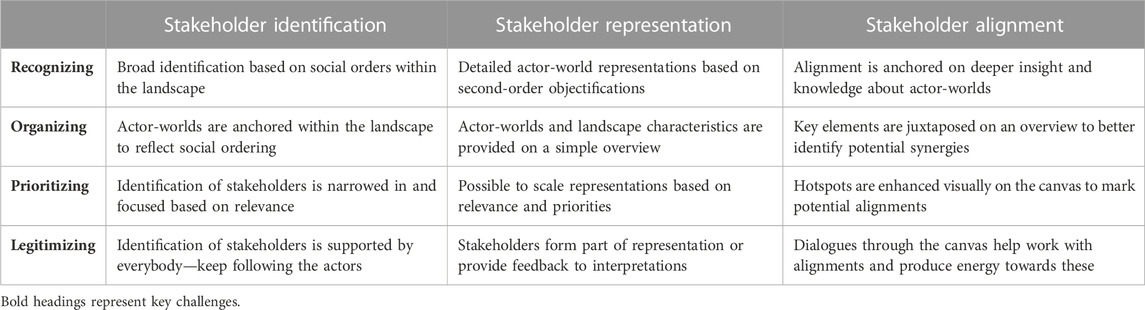
TABLE 2. Overview of the main characteristics of Actor-Landscapes based on the four key moments and the main endeavors of the tool to identify, represent, and align stakeholders.
This visual canvas shows potential as a boundary object by enabling water professionals and stakeholders to learn about each other’s differences and jointly transform their knowledge through adopted physical maps as a shared language. The shared graphic language of physical maps provide a useful starting point for dialogues and interactions. The representation of stakeholders as actor-worlds help to capture important differentiations between stakeholders and their distinct dynamics of social ordering. The iterative and dynamic character of working with Actor-Landscapes supports tinkering and bricolage with development of viable alignments in stakeholder interests. One of the key strengths of Actor-Landscapes is to build engagement and trust in the development processes by making involved stakeholders feel represented on the visual canvas. Unfortunately, it was not possible to explore the full extent of the potential of Actor-Landscapes as a boundary object as many of the studied processes were in the initial stage with main emphasis on providing a direction. This implies that the more design-oriented possibilities of Actor-Landscapes have not been sufficiently explored.
Actor-Landscapes provide an interesting way of representing actor-worlds in a very concrete and material way, and thereby provide an important supplement to the wide array of technical modelling tools prevailing in climate adaptation projects. More reflections and experiences are needed in terms of how to balance the simplicity and complexity of such visual canvases, so that these may represent actor-worlds in a more (theoretically) substantial way without losing the (practical) representational force of recognition and overview of situated social orders.
Data availability statement
The datasets presented in this article are not readily available because of the formats and data anonymity. Requests to access the datasets should be directed to UXVpdHphdUBwbGFuLmFhdS5kaw==.
Ethics statement
Ethical approval was not required for the studies involving humans because the study does not involve sensible ethical issues. It regards professional practices done in full consent with participating practitioners. It is not academic practice in Denmark to require ethical approval of such studies. The studies were conducted in accordance with the local legislation and institutional requirements. The participants provided their written informed consent to participate in this study.
Author contributions
All authors listed have made a substantial, direct, and intellectual contribution to the work and approved it for publication.
Funding
The work related to this article has been funded by the EU Life Coast to Coast Climate Challenge (C2CCC) with project number LIFE15IPC/DK/000006. The project has been led by Central Denmark Region and involved a large number of Danish municipalities, water utilities and universities.
Acknowledgments
The authors would like to acknowledge all the insights gained through meetings, workshops, and study trips during the EU Life C2CCC project. A special thank you to the municipalities of Hedensted, Norddjurs, Syddjurs and Silkeborg, as well as the Central Region Denmark, WSP, and the Limfjord secretariat for their engagement into developing and testing tools for actor and landscape mapping. The authors would also like to appreciate inputs from colleagues Miriam Jensen and Thomas Binder, as well as present and former colleagues from the PLUS research group that have contributed to this work.
Conflict of interest
The authors declare that the research was conducted in the absence of any commercial or financial relationships that could be construed as a potential conflict of interest.
Publisher’s note
All claims expressed in this article are solely those of the authors and do not necessarily represent those of their affiliated organizations, or those of the publisher, the editors and the reviewers. Any product that may be evaluated in this article, or claim that may be made by its manufacturer, is not guaranteed or endorsed by the publisher.
Reference
Banathy, B. H. (1996). Designing social systems in a changing world. Contemporary systems thinking. Springer Science.
Bryson, J. M., Crosby, B. C., and Bryson, J. K. (2009). Understanding strategic planning and the formulation and implementation of strategic plans as a way of knowing: the contributions of actor-network theory. Int. Public Manag. J. 12 (2), 172–207. doi:10.1080/10967490902873473
Callon, M. (1986b). “Some elements of a sociology of translation: domestication of the scallops and the fishermen of st brieuc bay,” in Power, action and belief: A new sociology of knowledge? Editor J. Law (London: Routledge), 196–233.
Callon, M. (1986a). “The sociology of an actor-network: the case of the electric vehicle,” in Mapping the dynamics of science and Technology, 19–34.
Carlile, P. R. (2002). A pragmatic view of knowledge and boundaries: boundary objects in new product development. Organ. Sci. 13 (4), 442–455. doi:10.1287/orsc.13.4.442.2953
Chavez M., Ghil M., and Urrutia-Fucugauchi J. (Editors) (2015). Extreme events: Observations, modeling, and economics (American Geophysical Union and John Wiley and Sons Inc).
Coghlan, D., and Brydon-Miller, M. (2014). The SAGE encyclopedia of action research. SAGE Publications Ltd.
Danish housing and planning authority (2022). “Vejledning i planlægning for forebyggelse af oversvømmelse og erosion (Guideline in planning for prevention of flooding and erosion),” in The Danish housing and planning authority.
DeWalt, K. M., and DeWalt, B. R. (2011). Participant observation: A guide for fieldworkers. AltaMira Press.
Ellis, E. C., Pascual, U., and Mertz, O. (2019). Ecosystem services and nature’s contribution to people: negotiating diverse values and trade-offs in land systems. Curr. Opin. Environ. Sustain. 38, 86–94. doi:10.1016/j.cosust.2019.05.001
Flyvbjerg, B. (2006). Five misunderstandings about case-study research. Qual. Inq. 12 (2), 219–245. doi:10.1177/1077800405284363
Frantzeskaki, N., Mahmoud, I. H., and Morello, E. (2022). “Nature-based solutions for resilient and thriving cities: opportunities and challenges for planning future cities,” in Nature-based solutions for sustainable urban planning. Editors I. H. Mahmoud, E. Morello, F. Lemes de Oliveira, and D. Geneletti (Springer), 3–18.
Gronim, S. S. (2001). Geography and persuasion: maps in British colonial New York. William Mary Q. 58 (2), 373–402. doi:10.2307/2674190
Harley, J. B. (1987). “Chapter 1: the map and the development of the history of cartography,” in Cartography in prehistoric, ancient, and medieval europe and the mediterranean (University of Chicago Press), 1–42.
Herr, K. G., and Anderson, G. L. (2005). The action research dissertation: A guide for students and faculty. SAGE Publications Inc, 8–28.
Hoffman, B., and Munthe-Kaas, P. (2020). “Staging urban design through experimentation,” in Staging collaborative design and innovation: an action oriented participatory approach. Editors D. Clausen, D. Vinck, Dorland, and S. Pedersen (Edward Elgar Publishing), 215–230.
Hoffmann, B., Laustsen, A., Jensen, I. H., Jeppesen, J., Briggs, L., Bonnerup, A., et al. (2015). Sustainable urban drainage systems: using rainwater as a resource to create resilient and liveable cities. State Green. Available at: https://stateofgreen.com/en/news/new-white-paper-on-climate-adaptation-launched-at-aquatech.
Hoffmann, B., Munthe-Kaas, P., and Jensen, J. S. (2015). “Navigation i netværk (Navigation in network),” in Innovativ klimatilpasning med borgere (Innovative climate adaptation with citizens). Editors B. Hoffmann, M. Elle, J. Dahl-Hansen, and A. Wejs, 30–41.
Ingold, T. (1993). “The temporality of the landscape,” in World archaeology (Conceptions of Time and Ancient Society), 25, 152–174.
Innes, J. E., and Booher, D. E. (1999). Consensus building as role playing and bricolage. Toward a theory of collaborative planning. J. Am. Plan. Assoc. 65 (1), 9–26. doi:10.1080/01944369908976031
Jensen, J. S., Fratini, C. F., and Cashmore, M. A. (2016). Socio-technical systems as place-specific matters of concern: the role of urban governance in the transition of the wastewater system in Denmark. J. Environ. Policy Plan. 18 (2), 234–252. doi:10.1080/1523908x.2015.1074062
Jensen, M. (2023b). Cultivating temporal attunement: unfolding the seasonalities of an unsettled river landscape. submitted to Time and Society.
Jensen, M. (2023a). Disturbed and disrupted: the temporalities of changing landscapes and their affective aftermath, submitted to Environment and planning E: Nature and space.
Jørgensen, U., and Sørensen, O. H. (1999). Arenas of development – a space populated by actor-worlds, artefacts, and surprises. Technol. Analysis Strategic Manag. 11 (3), 409–429. doi:10.1080/095373299107438
Koks, E. E., van Ginkel, K. C. H., van Marle, M. J. E., and Lemnitzer, A. (2022). Brief communication: critical infrastructure impacts of the 2021 mid-july western European flood event. I Nat. Hazards Earth Syst. Sci. 22, 3831–3838. doi:10.5194/nhess-22-3831-2022
Latour, B. (2005). Reassembling the social – an introduction to actor-network theory. Oxford University Press.
Lévi-Strauss, C. (1966). The nature of human society series. Weidenfeld and Nicholson.The savage mind
Lewin, K. (1948). “Action research and minority problems,” in Resolving social conflicts. Editor G. W. Lewin (Harper and Row), 201–216.
Lissandrello, E., and Grin, J. (2011). Reflexive planning as design and work: lessons from the port of amsterdam. Plan. Theory Pract. 12 (2), 223–248. doi:10.1080/14649357.2011.580156
Metzger, J. (2013). Placing the stakes: the enactment of territorial stakeholders in planning processes. Environ. Plan. A 45 (4), 781–796. doi:10.1068/a45116
Ministry of Environment of Denmark, (2013). Klimatilpasningsplaner og klimalokalplaner – vejledning (Climate adaptation plans and climate detailed plans – guidance). The Danish Nature Agency under the Ministry of Environment of Denmark.
Mitchell, R. K., Agle, B. R., and Wood, D. J. (1997). Toward a theory of stakeholder identification and salience: defining the principle of who and what really counts. Acad. Manag. Rev. 22 (4), 853–886. doi:10.5465/amr.1997.9711022105
Munthe-Kaas, P., and Hoffmann, B. (2017). Democratic design experiments in urban planning – navigational practices and compositionist design. Codesign 13 (4), 287–301. doi:10.1080/15710882.2016.1233284
Nielsen, B. S., and Nielsen, K. A. (2010). “Aktionsforskning (Action-research),” in Kvalitative metoder: En grundbog (qualitative methods: A basic book). Editors S. Brinkmann, and L. Tanggaard (Hans Reitzels forlag), 97–120.
Papazu, I., and Winthereik, B. R. (2021). “Indledning (introduction),” in Aktørnetværksteori i praksis (Actor-Network Theory in practice. Editors I. Papazu, and B. R. Winthereik (Djøf Forlag), 9–26.
Pedersen, R. A., Payne, M. R., Langen, P. L., Boberg, F., Christensen, O. B., Sørensen, A., et al. (2021). Klimaatlas-rapport danmark (climate atlas report Denmark). Danish Meteorological Institute.
Pedersen, S., Dorland, J., and Clausen, C. (2020). “Staging: from theory to action,” in Staging collaborative design and innovation: An action-oriented participatory approach. Editors C. Clausen, D. Vinck, and S. Pedersen (Edward Elgar Publishing Limited), 20–36.
Pineda, A. F. V., and Johansen, A. G. (2019). The difference between stakeholder analysis (SHA) and actor-network mapping (ANT). Blogpost, 15th of february 2019. https://planningforsustainabletransitions.design.blog/2019/02/15/the-difference-between-stakeholder-analysis-sha-and-actor-network-mapping-ant/.
Pouloudi, A., Gandecha, R., Atkinson, C., and Papazafeiropoulou, A. (2004). “How stakeholder analysis can be mobilized with Actor-Network Theory to identify actors,” in Information systems research, 705–711.
Quitzau, M., Gustafson, S., Hoffmann, B., and Krantz, V. (2022). Sustainability coordination within forerunning Nordic municipalities – exploring structural challenges across departmental silos and hierarchies. J. Clean. Prod. 335, 130330. doi:10.1016/j.jclepro.2021.130330
Raymond, C. M., Frantzseskaki, N., Kabisch, N., Berry, P., Breil, M., Nita, M. R., et al. (2017). A framework for assessing and implementing the co-benefits of nature-based solutions in urban areas. Environ. Sci. Policy 77, 15–24. doi:10.1016/j.envsci.2017.07.008
Reason, P., and Bradbury, H. (2008). “Introduction,” in The SAGE handbook of action research. Editors P. Reason, and H. Bradbury (SAGE Publications Ltd), 1–10.
Reed, M. S., Graves, A., Dandy, N., Posthumus, H., Hubacek, K., Morris, J., et al. (2009). in Journal of environmental management, 1933–1949.
Seneviratne, S. I., Zhang, X., Adnan, M., Badi, W., Dereczynski, C., Di Luca, A., et al. (2021). “Weather and climate extreme events in a changing climate,” in Climate change 2021: The physical science basis. Contribution of working group I to the sixth assessment report of the intergovernmental panel on climate change. Editors V. Masson-Delmotte, P. Zhai, A. Pirani, S. L. Connors, C. Péan, S. Bergeret al. (Cambridge, United Kingdom and New York, NY, USA: Cambridge University Press), 1513–1766.
Senge, P. M. (1990). The fifth discipline: the art and practice of the learning organization. Doubleday.
Star, L. S., and Griesmer, J. R. (1989). Institutional ecology, `Translations' and boundary objects: amateurs and professionals in berkeley's museum of vertebrate zoology, 1907-39. Soc. Stud. Sci. 19, 387–420. doi:10.1177/030631289019003001
Star, S. L. (1989). “The structure of ill-structured solutions: boundary objects and heterogenous distributed problem solving,” in Readings in distributed artificial intelligence. Editors M. Huhn, and L. Gasser (Morgan Kaufman), 37–54.
Stephan, P. F. (2015). “Designing ‘matters of concern’ (Latour): a future design task?,” in Transformation design, perspectives on a new design attitude. Editors W. Jonas, S. Zerwas, and K. von Anshelm, 202–226.
Tubridy, F. (2020). Green climate change adaptation and the politics of designing ecological infrastructures. Geoforum 113, 133–145. doi:10.1016/j.geoforum.2020.04.020
Vaajakallio, K., and Mattelmäki, T. (2014). Design games in codesign: as a tool, a mindset and a structure. CoDesign 10 (1), 63–77. doi:10.1080/15710882.2014.881886
Venturini, T. (2010b). Building on faults: how to represent controversies with digital methods. Public Underst. Sci. 21 (7), 796–812. doi:10.1177/0963662510387558
Venturini, T. (2010a). Diving in magma: how to explore controversies with actor-network theory. Public Underst. Sci. 19 (3), 258–273. doi:10.1177/0963662509102694
Keywords: mapping, climate adaptation, stakeholder, engagement, added value, municipality
Citation: Quitzau M-B and Hoffmann B (2023) Actor-landscapes as visual canvas for identifying, representing, and aligning stakeholders. Front. Built Environ. 9:1105544. doi: 10.3389/fbuil.2023.1105544
Received: 22 November 2022; Accepted: 07 September 2023;
Published: 18 September 2023.
Edited by:
Jianxiang Huang, The University of Hong Kong, Hong Kong SAR, ChinaReviewed by:
Xi Deng, The University of Hong Kong, Hong Kong SAR, ChinaPaul Cureton, Lancaster University, United Kingdom
Copyright © 2023 Quitzau and Hoffmann. This is an open-access article distributed under the terms of the Creative Commons Attribution License (CC BY). The use, distribution or reproduction in other forums is permitted, provided the original author(s) and the copyright owner(s) are credited and that the original publication in this journal is cited, in accordance with accepted academic practice. No use, distribution or reproduction is permitted which does not comply with these terms.
*Correspondence: Maj-Britt Quitzau, cXVpdHphdUBwbGFuLmFhdS5kaw==