Locating Relict Sinter Terrace Sites at Lake Rotomahana, New Zealand, With Ferdinand von Hochstetter's Legacy Cartography, Historic Maps, and LIDAR
 Andrew Martin Lorrey
 John-Mark Woolley
- Climate Atmosphere and Hazards Centre, National Institute of Water and Atmospheric Research (NIWA), Auckland, New Zealand
Te Otukapuarangi (the Pink Terrace), Te Tarata (the White Terrace) and Te Ngāwhā a Te Tuhi (the Black Terrace) were massive siliceous sinter formations at Lake Rotomahana, New Zealand, that were ostensibly lost in the catastrophic 1886 Tarawera eruption. Previous work using an unpublished watercolor map and notes by Ferdinand von Hochstetter (b. 1829–d. 1884) has recently supported claims that the former Pink and White Terraces survived the 1886 eruption, and that they may be located under tephra adjacent to the modern lake margin. Divergent perspectives about the fate of Lake Rotomahana's former sinter terraces suggest the reconstruction of New Zealand's largest historic volcanic eruption is incomplete. The undervalued approach of pairing modern geomorphic techniques with extant historic resources and geophysical data can help resolve this controversy. We harnessed a wider amount of unique historic data recorded during Hochstetter's (1859) survey than previously reported to locate the sites of Lake Rotomahana's former sinter terraces. Volcanic landforms, the physical geography of the countryside, and former settlements are tied together via common sightings between sequential survey datums. Light detection and ranging (LIDAR) data supported the reconstruction of Hochstetter's (1859) survey. Of significance, shared landmarks between the survey stations increased the confidence for resecting the 1859 datum position on the southern margin of former Lake Rotomahana. Hochstetter's survey watercolor maps are part of a series drafted prior to a final version being professionally printed, and they do not portray a spatially accurate depiction of how sinter terraces and geothermal features around former Lake Rotomahana were arranged. As such, assertions of their superior cartographic nature are not well-founded, and application of them to provide former Terrace locations is compromised. The published pre-eruption map of Lake Rotomahana validates well against Hochstetter's field diary measurements. When Hochstetter's published map is orientated using reconstructed survey datum positions at Lake Rotomahana, the former locations of the White and Pink Terraces lie entirely within the modern boundaries of the lake and not on land. The Black Terrace may have been destroyed and/or converted to an eruption crater, but may still exist on land (intact or in-part) west of Lake Rotomahana's modern shoreline. This study demonstrates the value of historic cartography to improve understanding of volcanic processes, and the potential to apply similar approaches to volcanic environments elsewhere that hold a range of pre-instrumental observations.
Introduction
Environmental observations focused on monitoring volcanic landscapes provide our society with a basis for early warnings, disaster preparation plans, and response strategies for a range of eruption types. However, the limitation of detailed and continuous monitoring outside the last half-century highlights the importance of historic information for outlining past volcanism—especially explosive episodes that caused widespread damage. Recent reconstructions show the potential of combining historic information with geomorphology, stratigraphy and geochronology to delineate explosive volcanic episodes and landscape processes (e.g., Karátson et al., 2018). As such, many yet-to-be harnessed written sources that captured historic eruption details and pre-eruption landscapes are an important resource for the volcanic research community. For New Zealand, Late Quaternary volcanic and geothermal activity within the Taupo Volcanic Zone (TVZ; Figure 1) has profoundly shaped the physical geography of New Zealand's central North Island region (Wilson et al., 1984, 1995, 2009; Lowe et al., 2008, 2013; Wilson and Rowland, 2016). Many New Zealand cities, towns and settlements lie within or near active and recently dormant volcanic centers both within and around the TVZ (Cox and Hayward, 1999). Given this risk, historic evidence related to the 1886 Tarawera eruption—one of the most significant in the history of New Zealand—is important nationally for guiding hazard assessment (MCDEM, 2015).
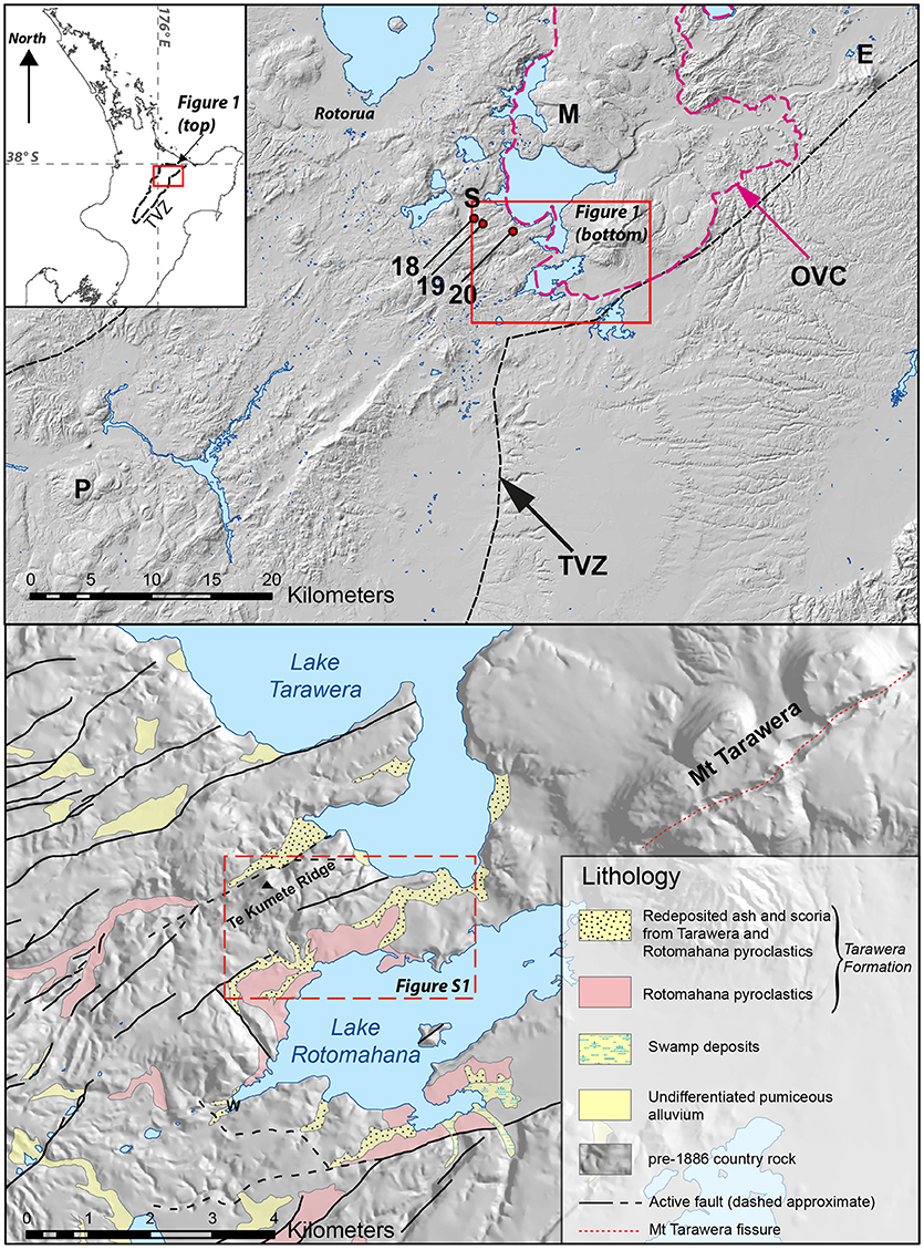
Figure 1. (Top) Location map of Lake Rotomahana and surrounding area in Rotorua, including places mentioned in the text (E = Mount Edgecumbe/Putauaki; S = Reverend Spencer's parsonage at Te Wairoa (Te Mu); M = Makatiti Dome; P = Pukeahua; TVZ = modern Taupo Volcanic Zone boundary; OVC = Okataina Volcanic Centre; 18-20 are Ferdinand von Hochstetter's survey stations (described and located in text). (Bottom) Simplified geologic map of the Lake Rotomahana region for the red box in the top panel (From GNS Science); W = Waimangu; red dashed line inset is LIDAR coverage shown in Supplementary Figure 1.
We present a significant example, using Lake Rotomahana in the central North Island of New Zealand, of how historical observations and maps, in conjunction with geomorphic analysis that applies high-resolution light detection and ranging (LIDAR) topographic data and GIS techniques, can help define consequences of explosive volcanism on civil infrastructure, economic interests, subsistence networks and life. Our study focuses on information about Lake Rotomahana before the 1886 Tarawera eruption, which we use to relocate the sites of the former sinter terraces (including the Pink and White Terraces; Figure 2) with respect to the modern landscape. We interrogated Ferdinand von Hochstetter's (1859) field diary and sketches to ascertain contemporary positions of former survey datums linked to his pre-1886 Lake Rotomahana maps. To aid our effort, we engaged a larger set of Hochstetter's survey data than was previously employed by other researchers, including tabulated bearings made at several sites northwest of the Lake Rotomahana basin. Available high-resolution LIDAR topographic data and historic maps for the Rotorua region helped to define the locations of Hochstetter's (1859) survey station datums. The re-assessment of Hochstetter's survey datum locations supported an appraisal of map reliability, which was then used as a basis to ascertain the former site locations and preservation potential of sinter terraces, geothermal features, and pre-1886 boundaries of Lake Rotomahana. The outcome of our work demonstrates the accuracy and utility of historic documents that describe volcanic landscapes, and supports the conclusion that the former Pink and White Terrace sites now lie beneath the modern lake.
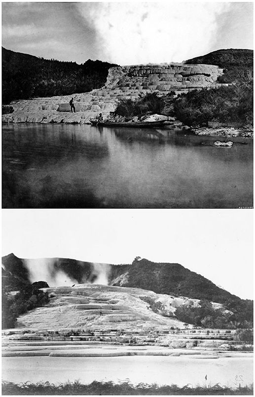
Figure 2. Photograph “The Pink Terrace Rotomahana” (Top) by Mundy (1826–1881) and “White Terraces, Rotomahana” (Bottom; photographer Unknown, 1870–1886) prior to the eruption of Mount Tarawera and the surrounding region during 10 June 1886. Reproduced with permission from Alexander Turnbull Library. View toward the Pink Terrace is from the former western lake shore looking west up the terrace, while the view of the White Terrace is looking approximately to the east-southeast from the northern lake shore.
Background
Regional Setting and Lake Rotomahana
Modern Lake Rotomahana was produced from the 1886 Tarawera eruption and it is one of many volcanogenic lakes located within the TVZ, sitting astride the southern margin of the Okataina Volcanic Centre (Nairn, 1981, 2002; Cole et al., 2010; Leonard et al., 2010; Figure 1). Prior to the twentieth century, major siliceous sinter formations adjacent to former Lake Rotomahana, called Te Otukapuarangi (fountain of the clouded sky; the Pink Terrace) and Te Tarata (the tattooed rock; the White Terrace), along with a smaller feature known as Te Ngāwhā a Te Tuhi (Tuhi's spring; the Black Terrace), constituted a taonga (treasure) to Māori (all three terraces are hereafter referred to as “The Terraces”). Like contemporary counterparts elsewhere that contribute to global volcano and geothermal tourism, The Terraces (Figure 2) were vital to the growth of the fledgling colonial era economy and commercial interests of Aotearoa New Zealand (Keam, 1988; Cooper, 2010; de Ronde et al., 2016b). These collective geothermal features were parochially termed “the eighth wonder of the World” due to their close arrangement, overwhelming beauty of macro-to-microscale cascading thermal basins, and great size with respect to other known sinter terraces located in the Northern Hemisphere (Keam, 2016).
The 1886 Tarawera Eruption
The multi-stage Tarawera eruption on 10 June 1886 (inclusive of Mount Tarawera and Rotomahana basin eruptive sites) was the biggest and most destructive event in New Zealand since Europeans arrived in the early nineteenth century (Keam, 1988; Lowe et al., 2002). Despite being a basaltic rather than rhyolitic event, the 1886 Tarawera eruption was highly explosive and it is one of a handful of examples globally that included a plinian-style eruption of scoria from a fissure source (Walker et al., 1984). The initial sequence of explosions on 10 June 1886 gouged out a series of craters through Mount Tarawera's antecedent rhyolitic domes, depositing the Tarawera Scoria Member of the Tarawera Tephra Formation (Froggatt and Lowe, 1990) over a substantial area extending at least ~50 km from source. While the plinian-style activity on Mount Tarawera continued, there was further propagation of rift-aligned fissures beneath the Lake Rotomahana basin to Waimangu valley (Nairn and Cole, 1981; Walker et al., 1984; Keam, 1988, 2016; see Figure 1 for location and geology details). Eruptions along the Rotomahana-Waimangu rift extension generated a series of phreatomagmatic explosions that catastrophically evacuated, deepened and enlarged the former Rotomahana lake basin (along with other smaller lakes within that area). Volcanic products from this phreatomagmatic phase include “muddy” deposits (Rotomahana Mud Member of the Tarawera Tephra Formation; Froggatt and Lowe, 1990) that rained out over much of the Bay of Plenty region and beyond. Near Rotomahana, there were violently-emplaced hot, fast-moving turbulent pyroclastic surges that swept outward and laid waste to the local countryside up to ~6 km from source (Nairn, 1979; Keam, 1988, 2016).
Up to 120 people were killed, either directly from explosive energy released during the pyroclastic surge event of the Rotomahana eruption sequence, or from impacts of tephra fall and collapse of buildings under the weight of tephra fallout (Lowe et al., 2001; Keam, 2016). The destruction of former Lake Rotomahana and regional devastation from the Tarawera eruption had profound and long-lasting impacts on the local iwi (tribe) Thourangi, their hapu (subtribe(s)), as well as the fledgling British colony (Lowe et al., 2002). Eyewitness reports and photography from the late nineteenth century suggested Lake Rotomahana's Pink and White Terraces (Figure 2) were destroyed and/or buried during this severe event (Smith, 1886, 1887; Valentine, 1886; Thomas, 1888), despite persistence of a minority opinion of their survival (Nikora, 1936). Popular perspectives about the destruction and loss of The Terraces became solidified in the literature and entrenched in public sentiment after survivors passed away (Bunn and Nolden, 2016).
Controversy About the Former Site Locations and Survival of the Terraces
Renewed interest in the fate of relic massive siliceous sinter terraces at Lake Rotomahana was primed in the last decade by two independent research initiatives. Remote geologic surveying of the Rotomahana basin has revealed new insights about bathymetry, geomagnetism, lake water geothermal composition, and hydrographic properties that enrich our understanding of the TVZ and Okataina Volcanic Centre (e.g., de Ronde et al., 2016a,b; Walker et al., 2016). In addition, a series of historic watercolor manuscript maps and related notes for Lake Rotomahana from Ferdinand von Hochstetter's field diaries were discovered in Basel, Switzerland (Johnston and Nolden, 2011; Nolden, 2014). Hochstetter, who is considered the “Father of New Zealand Geology,” produced the Lake Rotomahana watercolor maps (Johnston and Nolden, 2011) during his time at the lake and also after he left that site in 1859 (Sascha Nolden, personal communication, 2018).
Hochstetter's (1859) survey bearings (Supplementary Figure 2) and watercolor map sketches document Lake Rotomahana and the Rotorua landscape (Johnston and Nolden, 2011; Bunn, 2016; Bunn and Nolden, 2016, 2018). They contain details about The Terraces, small geothermal features that existed around Lake Rotomahana, and even some distant landmarks that were within eyesight (see landmarks on Figure 1). Hochstetter's Lake Rotomahana survey was the only one formally published in map form prior to the 1886 Tarawera eruption. In addition, his watercolor depiction of Lake Rotomahana in 1859 (a version including thermal details; seen in Bunn and Nolden, 2018) is intriguing because it appears different from published versions that were released starting in 1862 (Figures 3A,B), including several iterations in different languages (Marshall, 1998).
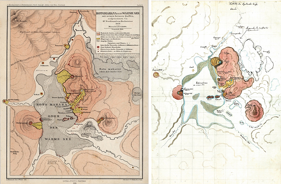
Figure 3. (Left) Lake Rotomahana map from Justus Perthes of Gotha (Hochstetter and Petermann, 1863) and (Right) Hochstetter's watercolor map of Lake Rotomahana based on his notes from the 1859 field survey. -The latter was recently used by Bunn (2016) and Bunn and Nolden (2016, 2018) to suggest the former sites of Te Tarata, Otukapuarangi, and Ngāwhā a te Tuhi (the White, Pink, and Black Terraces) were located partly or wholly on land.
Some of Hochstetter's field observations were evaluated in multiple phases across two peer-reviewed papers (Bunn and Nolden, 2016, 2018) via a novel “cartographic resection” of a primary 1859 survey datum at Lake Rotomahana. The latter of the two papers (which we term BN18 henceforth) produced a projection for former Lake Rotomahana based on the 1859 watercolor map over the current landscape. The orientation and scaling of the 1859 map in BN18 was then used to support claims that all or parts of The Terraces were not destroyed, but could still be on land (in-whole or in-part) buried beneath the Rotomahana Mud.
Since that assertion was published, a re-assessment of Hochstetter's tabulated bearings at Lake Rotomahana has suggested conclusions BN18 drew from their projection of the 1859 watercolor map may not be reliable (Keir, 2017). A team of geoscientists involved in surveying modern Lake Rotomahana have refuted the assertions about the former Pink and White Terrace locations on land (de Ronde et al., 2018). The work of BN18 has recently been updated, with adjustments to the orientation and scaling of the 1859 watercolor map that push the White Terrace former site location entirely onto land adjacent to the northern shore of modern Lake Rotomahana (Bunn et al., 2018). Thus, an alleged controversy exists about the former Terraces site locations within the modern landscape, and whether or not they could have survived the 1886 Tarawera eruption (either partly or wholly intact).
Few sites as unique and dramatic as Lake Rotomahana existed, where the first written historic accounts of geothermal features are constrained to the last phase of their presence prior to obliteration from a highly destructive eruption. A comprehensive cartographic view of the Lake Rotomahana landscape did not exist prior to the 1886 Tarawera eruption. Despite nineteenth century narratives that included primary geological descriptions with early photographs, the 1859 survey of Lake Rotomahana by Ferdinand von Hochstetter was essentially undertaken in cartographic isolation. As such, improved context for that pioneering survey and better definition of how former geothermal features at Rotomahana were arranged, including the whereabouts of The Terraces, can help connect the past landscape to modern lake-bottom geological surveys (e.g., de Ronde et al., 2016a). In addition, refining Lake Rotomahana's former sinter terrace configurations before and after the 1886 eruption can enrich the regional Quaternary volcanic history of New Zealand (Keam, 2016), and add value to TVZ contemporary volcanogenic processes (see references in de Ronde et al., 2016a, 2018) by offering new insights about how magma plumbing systems operate.
Data and Methods
High-resolution digital surrogate copies for several of Hochstetter's watercolor maps and bearings from his field journal that were found in the Hochstetter Collection Basel were kindly supplied by Dr. Sascha Nolden and Sandy Nolden (shown in the text and Supplementary Figures 1–3). Bearings used to reconstruct Hochstetter's survey between Te Wairoa (the village with Reverend Charles Spencer's parsonage where Hochstetter stayed) and Lake Rotomahana are cataloged in Table 1. In addition, the Lake Rotomahana geothermal feature map dating to 1863 (from the German version of the New Zealand Geological and Topographic Atlas that was published by Justus Perthes of Gotha; Hochstetter and Petermann, 1863; Figure 3A) was used in a direct comparison to the 1859 watercolor version seen in BN18 (Figure 3B). Other map versions in watercolor and printed form are used in the discussion.
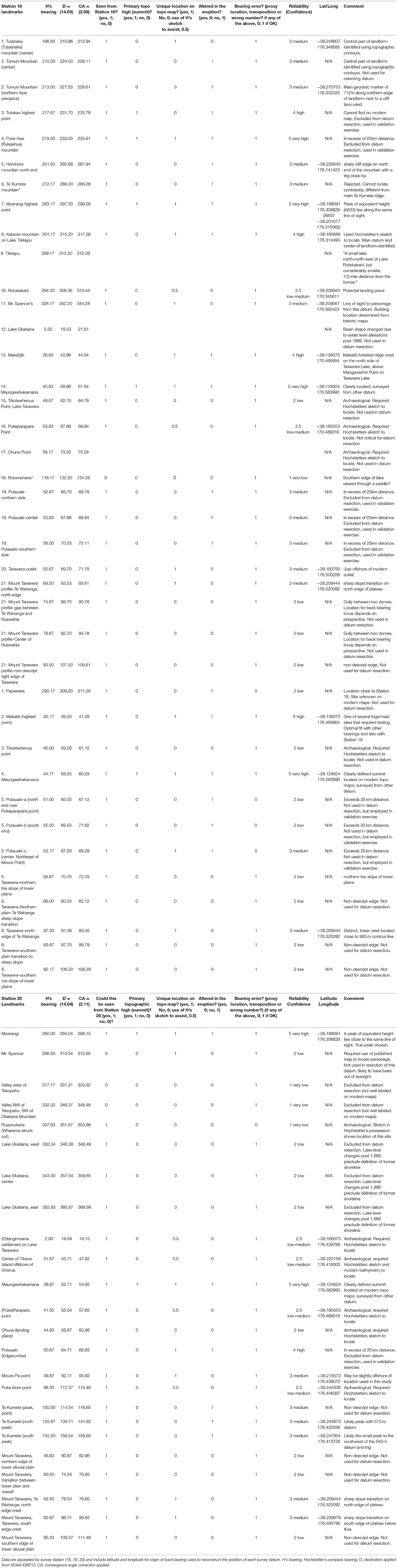
Table 1. Bearings to landmarks taken by Ferdinand von Hochstetter at three separate survey stations in the area between Te Wairoa and Lake Rotomahana during April 1859.
An objective classification scheme was applied to bearings Hochstetter took at four survey sites. It was used to rank and ascribe confidence for reconstructing former datums, considering the following details:
• whether each landmark could actually be seen from the datum,
• whether landmarks constituted a primary topographic high point (e.g., a summit),
• whether landmarks could be uniquely located on a modern topographic map (e.g., a secondary peak or via a named place),
• whether or not landmarks were potentially altered in a major way during the 1886 eruption, and
• whether or not the bearing may be erroneous or contain error (e.g., if it is a “proxy line of site” for a place that cannot be directly seen, or if transposition, notational data, or wrong numbers altogether may be present).
If a bearing to a target landmark positively satisfied all five categories, it would receive a rating of “5” and should be highly valuable for a datum resection (especially if it is nearby). A landmark with a rating of “0” would mean that it satisfied none of the criteria and should be rejected due to unreliability. Based on a scale of 0 to 5, we ascribed relative confidence in the bearings to each landmark using a scaling method applied in consensus decision-making for earth science modeling (0 = unreliable, 1 = very low, 2 = low, 3 = medium, 4 = high, 5 = very high; Mastrandrea et al., 2010). Historic photographs and Hochstetter's sketch maps also support general locations for some of the landmarks—e.g., Te Ariki and Reverend Spencer's parsonage in the settlement of Te Wairoa), which follows similar approaches employed by BN18 to ascribe initial locations for old survey landmarks.
Three datum sites were along the journey from Te Wairoa to Lake Rotomahana (Stations 18–20; Table 1) and one site is at the former southern lake margin (Station 21; Tables 2, 3). Hochstetter's bearings for Lake Rotomahana at Station 21 were divided into two categories, external and internal landmarks. For Station 21 bearings taken at Lake Rotomahana, the external bearing category (Table 2) includes all landmarks positioned beyond Lake Rotomahana that could have potentially survived the 1886 Tarawera eruption. The internal bearing category (Table 3) were classified as landmarks at and around the lake that were directly impacted and/or partially or completely modified or destroyed by the 1886 Tarawera eruption. For Stations 18-20, some landmarks were omitted from usage because they were potentially lost via lake level changes after 1886, or because they could not be located with enough certainty on a modern map.
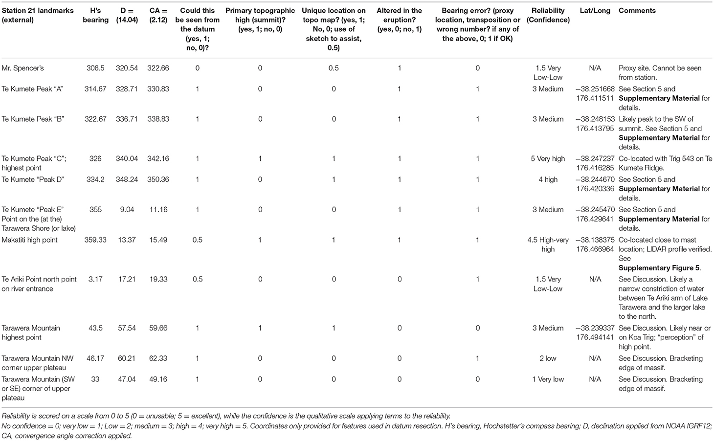
Table 2. Objective classification scheme applied to external landmarks (outside the immediate lake environment) contained in Hochstetter's survey at Lake Rotomahana.
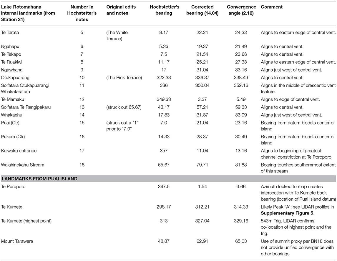
Table 3. Tabulated bearings with corrections for Hochstetter's survey of internal landmarks at Lake Rotomahana from Station 21 and all landmarks shot in from Puai Island.
Azimuths drawn from each landmark Hochstetter surveyed produced intersection points that can be used to evaluate potential locations for his former survey datums. Bearings from each surveyed landmark projected back to a datum is referred to as a reciprocal bearing or back bearing. Previous work indicated that an azimuth compass was used for Hochstetter's (1859) survey, consisting of magnetic bearings (Bunn and Nolden, 2016, 2018). Declination corrections are therefore required to align those magnetic compass bearings relative to north-south grids used in modern cartographic map projections. For declination in 1859, we considered historic Admiralty maps (termed Admiralty Declination; See Supplementary Figure 6), geomagnetic survey measurements from the scientific report of the “Novara” (which Hochstetter contributed to undertaking; Müller, 1862–1865; Supplementary Figure 7), and the International Geomagnetic Reference Field (IGRF) model (version IGRF 12) available online from the National Oceanic and Atmospheric Administration (NOAA) National Centers for Environmental Information. IGRF12 allows historic declination calculations for land and sea back to 1590CE (https://www.ngdc.noaa.gov/geomag-web/#declination).
New Zealand grid maps were sourced from Land Information New Zealand (LINZ) Topo50 series (https://www.linz.govt.nz/land/maps/topographic-maps/topo50-maps), which are projected on a New Zealand Transverse Mercator 2000 (NZTM2000) grid. The horizontal datum is New Zealand Geodetic Datum 2000 (NZGD) and the vertical datum is mean sea level. All regional maps used were downloaded at 1:50,000 scale with 20-meter vertical contour spacing. These were imported to Adobe Illustrator to allow precise plotting of bearings and azimuths, and to accommodate overlays of historic and contemporary maps of Lake Rotomahana. Subsequent bearing checks were performed in ArcGIS and using autocad software.
To plot bearings from non-adjustable compasses like the one Hochstetter likely used (e.g., azimuth compass; Bunn and Nolden, 2016) over Topo50 maps, bearings needed to be corrected by adding the magnetic bearing (Table 1) and the magnetic declination for 1859. This correction amount is similar for survey sites at and NW of Lake Rotomahana (within 0.01° of arc; 14.03°-14.04°). The small variation between the survey sites is well within the precision of the compass Hochstetter employed.
A convergence angle correction (difference between grid north and true north) also requires consideration (previously noted as important by Keir, 2017). The central meridian for the NZTM2000 grid is 173°W longitude, where both grid north and true north are aligned. Across the area where Hochstetter's stations analyzed in this study were located, the convergence angle increases from ~2.08°E to ~2.12°E (increasing 0.01° for every minute of longitude traveled west to east).
We grouped bearings by survey station and then applied the 1859 magnetic declination, then convergence angle correction was added to that sum to produce a grid-north bearing (see Table 1 for declination and convergence angle corrections applied at different stations).
Relative positions for each of Hochstetter's survey stations from his relic field maps (Nolden and Nolden, 2013) allowed an initial assignment of declination and convergence angle corrections. Sensitivity of convergence angle corrections shows similar intersection points for bearings when the correction is changed by +/−0.01°. As expected, intersections of reciprocal bearings based on landmarks far from each survey datum shows the greatest change when slightly altering the convergence correction.
All of Hochstetter's compass bearings end in a round number at the nearest 10-min interval, which indicates internal precision for surveyed landmarks was no better than +/−0.17 degrees. Precision error for these bearings greatly exceeds the uncertainty for the convergence angle correction. For plotting Hochstetter's bearings, a conservative error margin of +/−0.50° encapsulates twice the range of compass measurement accuracy and precision, declination, and convergence angle adjustments combined.
Some volcanic landforms that Hochstetter surveyed (e.g., Mount Edgecumbe-Putauaki) were within eyesight but located at great distance (exceeding 25 km). This means those survey bearings could artificially inflate error when resecting a datum based on back bearings. As such, landmarks >25 km away from Hochstetter's survey stations were not used for primary datum resection. However, those landforms were assessed in a subsequent survey validation step to determine whether or not Hochstetter's reconstructed datum locations contained lines of sight that reasonably captured the wider (and deeper) vista.
Many of Hochstetter's bearings to volcanic landforms include mountain edges, gullies, or slope transitions that are open to subjective interpretation, and some landmarks are no longer seen on modern maps. For “lost” sites, we utilized Hochstetter's sketch maps to ascribe as close a location as possible in the modern cartography, but penalized back bearing intersections that utilized those landmarks. We discounted bearings where definition of a precise location was lacking (e.g., a subjective landform, including some non-descript edges of Mount Tarawera).
Google Earth was previously used to indicate geomorphic details of the Lake Rotomahana pre-1886 landscape (see BN18 for details). LIDAR provides a clearer assessment of the topography around Lake Rotomahana and the Rotorua region that conventional geodetic maps with 20-meter vertical contours and the Google Earth digital elevation model (DEM) cannot clarify. LIDAR topographic details allowed us to ascertain whether Hochstetter was sighting well-defined topographic highs that were visible from afar (trigonometric stations) or local high points. We processed LIDAR data to depict the study region, collected by NZ Aerial Mapping and sourced from the Bay of Plenty Regional Council. This LIDAR dataset was post-processed to remove non-ground points, and when compared with independently surveyed field points, vertical accuracy of the dataset approaches ±0.50 m (within 68% confidence bounds). Hundreds of thousands of LIDAR data points provided a one-meter resolution DEM, and two-meter topographic contours were generated for the study area using tools provided in ArcGIS v10.4. This topographic detail is an order of magnitude finer than the geodetic maps publically available for the area north of Lake Rotomahana. This data resource was also used in geomorphic interpretations.
Results
Evaluation of 1859 Watercolor and 1863 Published Map Versions of Lake Rotomahana
Fourteen bearings in Hochstetter's notes document (internal) landmarks around or close to Lake Rotomahana's shoreline in 1859 (Table 3). We evaluated these bearings relative to the 1859 watercolor map presented in BN18 and the 1863 map published by Justus Perthes of Gotha (Hochstetter and Petermann, 1863). Checks for map orientation, internal accuracy and precision were made identically for both products using Hochstetter's uncorrected bearings. All Station 21 internal bearings (Table 1) aligned to the 1863 map landmarks with consistent precision (Supplementary Figure 8A) and within the range of compass error. We noted a subtle left-hand offset between each landmark and main point of convergence for these bearings at the datum symbol. This offset suggests the datum symbol on the 1863 map may not be in the correct position, and that it should instead be placed southeast of where it is located. Overall, this shift does not change the conclusion that the 1863 Justus Perthes of Gotha map (Hochstetter and Petermann, 1863) is a projection of the Lake Rotomahana area relative to magnetic north in 1859.
The same landmark bearings plotted against the 1859 watercolor map achieve moderate agreement with Hochstetter's survey, but only after they are corrected for declination. Nine of 14 features arguably have a correct alignment after accounting for declination (Supplementary Figure 8B). Five landmarks in the watercolor map do not correspond to corrected bearings (see Table 3), and include Whakaehu, Te Otukapuarangi (the Pink Terrace) and Te Whakataratara solfatara, the Kaiwaka River entrance, and Te Tarata (the White Terrace). This result is similar to the first re-assessment of Hochstetter's bearings for the 1859 watercolor map (undertaken by Keir, 2017). Because only about half of the landmarks on the watercolor are positioned with accuracy relative to the tabulated bearings, we consider the published 1863 map is a superior depiction of how geothermal features (including The Terraces) were arranged at Lake Rotomahana. We use the 1863 map in further analysis, and set aside the 1859 watercolor map for discussion.
Evaluation of Landmarks Constraining von Hochstetter's (1859) Survey Datums
Survey Datums Leading Up to Lake Rotomahana (Stations 18-20)
Hochstetter established three datums at Stations 18, 19, and 20 as he traveled between Reverend Spencer's missionary station at Te Wairoa (Te Mu block) and Lake Rotomahana. His detailed sketch maps indicate the approximate locations of each datum (Figure 4), and a brief description in his field notes indicates that Station 19 was situated about half a mile east-southeast of Station 18 (see Figure 4 and bearing notes in Supplementary Figure 4). Stations 18-20 were all located on high ground south of Lake Tarawera (Station 18 is referred to, in part, as the Papawera plateau). Each location offered clear lines of sight to prominent landforms, lake-shore settlements and points (small promontories), some of which can be identified on modern maps. All three of these stations had common landmark bearings to Maungawhakamana, Putauaki, and Mount Tarawera (Table 1). Some landmarks Hochstetter surveyed include a few Māori settlements along the former Lake Tarawera shoreline (Figure 4) that were inundated by rising water after the 1886 eruption. We were able to ascertain positions for some of those sites (see Table 1).
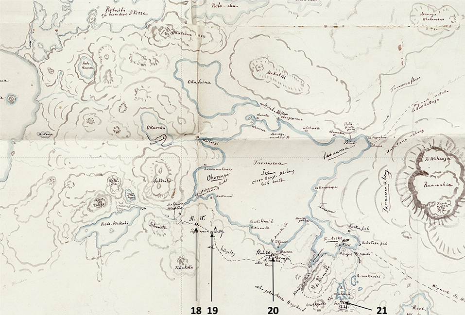
Figure 4. Detailed sketch map of Rotorua penned by Ferdinand von Hochstetter that encapsulates major landforms in the region and his survey station transect (18–20) en route from Mr Spencer's parsonage at Te Wairoa to Lake Rotomahana (where Station 21 was located). Reproduced from (Nolden and Nolden, 2013) and modified with permission from those authors.
Landmarks surveyed from Stations 18, 19, and 20 (Table 1) produced convergent back bearings that clustered, for the most part, within a radius of ~150 m. A 50 m2 grid covering 1 km2 over each datum area shows back bearing intersection densities (Figure 5). Based on the greatest density of intersecting points, we identified the most likely location for Hochstetter's Stations 18, 19, and 20 (within +/−50 m). The reconstructed location for Station 19 shows it was ~115° and ~800 m distant from Station 18 (Figure 5). This reconstruction fits well with Hochstetter's notes that state an approximate direction of ESE and a distance of half a mile between those two sites.
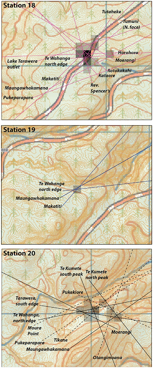
Figure 5. Back bearing intersections from landmarks that were surveyed by Ferdinand von Hochstetter at three datum leading up to (Station 18–20) overlain on New Zealand Topo50 (version 2009). Spatial density plots along with LIDAR-based contours at 2 m vertical intervals are superpositioned on the standard topographic map, and show where two or more landmark back bearing intersections are located within a 50 m2 grid cell. Only bearings that scored medium-very high scores were used (excluding landmarks in excess of 25 km from the survey site).
Stations 18 and 19 contain bearings to Makatiti Dome, which is an external landmark in common with Station 21. By reconstructing Station 18 and 19 datums, and their convergence on Makatiti Dome, we gain confidence about the location Hochstetter shot to from Station 21. Back bearings from the mast/tower symbol on Makatiti Dome cut across a swarm of intersections for landmarks shot from Stations 18 and 19. A world-wide web search using the phrase “tower on Makatiti Dome” revealed documentation of a very large rata (Metrosideros spp), ~45 m tall, once stood near that location, potentially growing as a parasite off the tallest tree in the area (https://register.notabletrees.org.nz/tree/view/1347). At the very least, this relict rata tree indicates the canopy height above the ground surface that Hochstetter would have observed in 1859 (Matt McGlone, personal communication, 2018). Geodetic maps and LIDAR shows the mast site is not located on the highest point for Makatiti Dome, but there is local high point close by (38.138375°S; 176.466964°E) that was clearly visible from both Station 18 and 19. That local high spot was chosen as the back bearing origin for Makatiti Dome in our study.
Station 21 and Puai Island Datums at Lake Rotomahana
Hochstetter shot eleven external landmarks from Station 21 at Lake Rotomahana (Figure 3; Table 2). Just over half (six) achieved qualitative scores of medium, high or very high confidence, and just under half (five) were very low or low confidence (Table 2). LIDAR near Te Kumete highest point and Te Kumete fourth peak shows Te Kumete's true highest point and the trig for that peak are co-located. The “515m” point on Te Kumete peak “D” and the true highest point for that sub-peak are not co-located. When the highest points for both landmarks were selected, a near-unified convergence with the bearing to Makatiti Dome emerges. When the locations for three medium confidence external landmarks (Te Kumete “Peak A,” “Peak B” and Mount Tarawera highest point) were used according to the sites chosen by BN18, they had poor convergence with the datum locus provided by high-very high landmarks used in this study. This demonstrates the choices by BN18 may have been subjective. Consequently, we reject the locations BN18 selected for those medium confidence sites, and rely on intersections of bearings from high-to-very high confidence landmarks as the primary basis for Hochstetter's Station 21 in the modern landscape. An interim reconstructed datum location for Station 21 based on those three points is 38.271028°S latitude; 176.427264°E longitude (NB: not final location choice), which lies within a tightly constrained area close to the middle reach of eastern Lake Rotomahana (Figure 6). LIDAR-based profiles for Te Kumete Ridge and Makatiti Dome taken from this location are shown in Supplementary Figure 5. We discuss use of landmarks along this profile for refining the Station 21 location in more detail below.
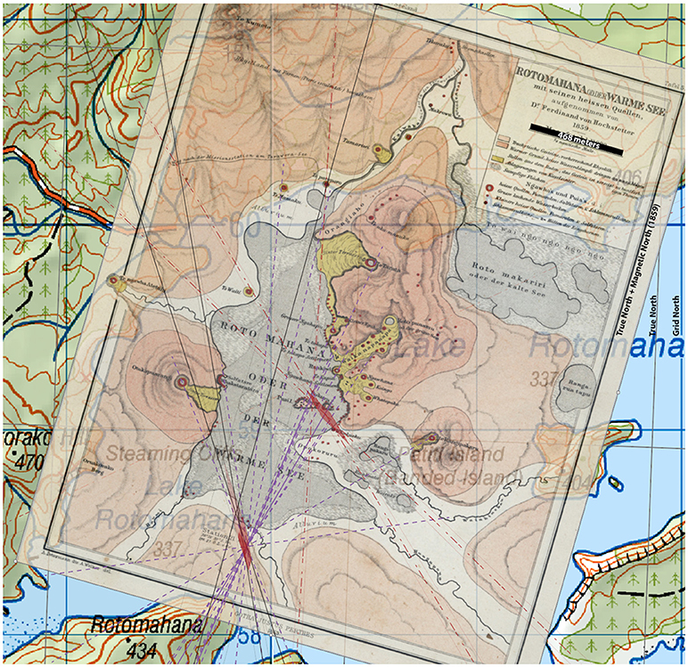
Figure 6. Hochstetter and Petermann (1863) published map scaled and plotted over New Zealand Topo 50 version 2009 based resection of Station 21 and Puai Island datum. Purple lines are bearings taken from Station 21 to internal landmarks (sinter terraces and springs) that were impacted by the eruption (destroyed, modified and or buried by tephra). Solid black lines are high and very high quality landmarks external to Rotomahana used to resect Station 21. Red dashed lines are bearings taken from Puai Island. Solid purple lines with arrows show survey bearings from Station 21 bisecting Puai and Pukura islands. The 1863 map is orientated relative to grid north. Red shading indicates error envelopes based on all high quality and reconciled bearings (see discussion). True north grid lines (WGS84) are shown in gray, while NZG2000 grid is in dark blue. Black bar superimposed along the linear map scale corresponds to 468 meters (1/4 nautical mile).
Hochstetter established a minor survey site on Puai Island at Lake Rotomahana in 1859 that was not formally ascribed as a main observation station. It is also not Station 22, as asserted by BN18, as that station was assigned and located in the Rotorua area by Hochstetter after he left Rotomahana. Puai Island provided good access to the lake from local accommodation, and clear lines of sight to Rotomahana's prominent geothermal features. BN18 duly noted difficulties in resecting the benchmark on Puai in the absence of a reciprocal bearing back to Station 21. One internal and three external landmarks were shot by Hochstetter from Puai Island. Based on the point of origin locations selected by BN18, back bearings for the external landmarks do not converge on a single location (Figure 6). As such, multiple solutions with respect to positioning Puai relative to Station 21 emerged. We addressed the validity of some of those solutions in the map orientation and scaling exercise (see section Map Orientation and Scaling Using Station 21 and Puai Island Datums as Anchors), and via a re-assessment of non-convergent landmarks from Station 21 and Puai Island (section Reconciling Non-convergent Bearings Shot From Hochstetter's Rotomahana Datums).
Reconciling Non-convergent Bearings Shot From Hochstetter's Rotomahana Datums
Several of the very low, low, and medium confidence bearings for landmarks with uncertain locations may be reconciled relative to an initial resected datum location founded on high-very high confidence bearings (see previous section). Inevitably, excluding lower confidence bearings has little influence on defining the main datum locations at Rotomahana (inclusive of error) based on by high-very high confidence bearings (Figure 5). However, those lesser quality bearings can help to refine the constraints of the datum within the error bounds of the highest quality landmarks, so they are worth examining. Determining the point of origin for these back bearings is highly critical for this exercise.
Reverend Spencer's (Table 1) may have been able to be viewed from Station 18, or possibly Station 19, as evidenced by location of Te Wairoa buildings on archaeological maps (Simmons, 1991). However, any direct line of sight bearing from Station 21 at Lake Rotomahana to this location was interrupted by high hills (Figure 1); hence, even though we know where Reverend Spencer's was (Simmons, 1991), we discarded the Station 21 bearing to that landmark because it is only a proxy as viewed from Rotomahana.
Peak A, B, and E on Te Kumete ridge can be reconciled using an oblique digital elevation model view (Supplementary Figure 5A) from the initial reconstructed position for Station 21 that is based on stronger bearings (see previous section). The first two peaks are prominent along the ridgeline to the southwest of Te Kumete's main summit. The bearing for “Pt am Tarawerasee” or Punkt am Tarawerasee; Point on the Tarawera lake; interpreted by BN18 as Mataneho Point) is vague for a discrete location on the lake edge; however, that bearing aligns to the shoulder of the Te Kumete ridge before it descends eastward into Lake Tarawera (Supplementary Figure 5A).
The bearing for “Te Ariki north point on the river entrance” does not align to where Te Ariki settlement was potentially located. However, extension of that bearing from Station 21 further afield shows that it intersects the narrowest part of Lake Tarawera located between the Te Ariki arm of the lake and the larger connected body of water to the north. Examination of Hochstetter's historic sketch (Figure 4) shows different portions of Lake Tarawera were formerly referred to as three distinct but connected entities (Ohorongo, Tarawera and Te Ariki; Figure 4). The lake level in 1859 was much lower than today, and constriction between Te Ariki and Tarawera may have appeared even more narrow, much like a river flowing from one body of water (Te Ariki) to another (Tarawera). Perhaps this is what Hochstetter perceived from Station 21, but in absence of certainty, we did not use this landmark for the final datum reconstruction.
We initially put aside the bearings to Mount Tarawera high point from Station 21 and from Puai Island because that mountain top was altered from the 1886 eruption. One reconciliation is the highest point Hochstetter may have perceived for Mount Tarawera from both Rotomahana datums was the southwestern edge of Tarawera Dome near Koa trig (1024 m). Reconciliation of these two incongruent points as plotted in the final datum resection does not change the result of where Puai Island or Station 21 could be positioned, or the scaling that was applied to the 1863 map.
One bearing for a corner of the Tarawera plateau (Table 2) had SW (southwest) and SO overwritten (O = east; SO = southeast); we do not know which of these is correct, so we tested both. If SW is taken as Tarawera Dome (the SW corner of the upper plateau), the bearing fits the northern edge of the SW part of the massif, similar to other bearings that Hochstetter used to define the edge of that landform at stations prior to Rotomahana. Hochstetter could not see the NW face of Tarawera from the southern shore of Lake Rotomahana; so, perhaps he meant to correct “NW” to “NO” (northeast), instead of correcting “SW” to “SO” (southeast) in his bearing table. If that reasoning is accepted, then opposite edges of Tarawera Dome are bracketed. He made similar bracketing bearings to other volcanic landforms from Stations 18-20. These Mount Tarawera landmarks were not used in the final solution for reconstructing Station 21.
Map Orientation and Scaling Using Station 21 and Puai Island Datums as Anchors
Station 21 and the Puai Island datums provide two anchors and an associated scaling mechanism for Hochstetter's (1863) map, presuming the spatial positioning of each site on that map are sound. Two things need to be achieved to satisfy Hochstetter's observations when scaling the 1863 map based on the two datum locations. First, the Station 21 bearing to Puai Island needs to bisect the island center. Second, the intersection of bearings for Te Poroporo (a hot spring seen on the map) and Te Kumete summit need to intersect Puai Island, because they were taken from the same spot on that island. We locked the back bearing for Te Poroporo to that feature on the 1863 map, then orientated the map (originally drawn relative to magnetic north) for declination and convergence (14.04°E + 2.12°E = 16.16°E). This created an intersection with Te Kumete summit bearing.
Hochstetter shot a bearing through the center of Puai Island from Station 21, and three bearings from Puai Island to surrounding landmarks, including Te Kumete's highest point (“Peak C”), a peak he observed to the left of the main Te Kumete summit, and Mount Tarawera highest point (assumed to be the summit 200 yards east of Ruawahia trig Smith, 1886 by BN18). The Puai Island back bearings from these external landmarks, following previous work (BN18), did not mutually intersect and initially gave multiple solutions for the Puai datum location. In the first instance, two of these solutions (based on BN18 point of origins for a peak Hochstetter observed to the left of Te Kumete's main summit, and Mount Tarawera highest point) appear unrealistic, because the associated scaling of the 1863 map would place Te Tarata too far north and into or beyond the modern Kaiwaka River valley. The only viable option was to initially work with the intersection of the Te Kumete ridge summit back bearing to Puai Island and Station 21 bearing to Puai Island (Figure 6). We then attempted to incorporate lower confidence bearings reassessed using newly ascribed points of origin (see section Reconciling non-convergent bearings shot from 456 Hochstetter's Rotomahana datums), which achieved much better success for obtaining mutual back bearing intersections.
The map was scaled so the Station 21-to-Puai Island bearing bisected the middle of Puai island. The error bounds for the highest quality bearings and reconciled low quality bearings are largely convergent, and they yield locations for both the Puai Island datum near the northeast edge of the island (38.265637°S; 176.431153°E) and a refined location for Station 21 (38.272110°S; 176.427773°E) where both the high confidence and most of the lower confidence bearings overlap. The results of this map scaling and orientation are addressed further in the discussion.
Projected Locations for the Former Pink, White, and Black Terraces
Orientation and scaling of the 1863 map within modern cartographic space (see section Map Orientation and Scaling Using Station 21 and Puai Island Datums as Anchors) allowed us to evaluate the location of Lake Rotomahana's former sinter terrace sites. We emphasize here that locations that are identified for these features are highly dependent on Hochstetter and Petermann's cartography in the 1863 map version, and these results could differ from other solutions that opt to use other map iterations and data sources.
Central vent coordinates for geothermal features located along the former Rotomahana lake edge (including Te Tarata and Otukapuarangi) are listed in Supplementary Table 1. The White Terrace and Pink Terrace former sites are located well within the boundaries of modern Lake Rotomahana. Based on the projection of Hochstetter's (1863) map in this study, the Black Terrace is depicted in a side valley off the northwest end of Lake Rotomahana (Figure 3B), and is positioned (based on results in Section Map Orientation and Scaling Using Station 21 and Puai Island Datums as Anchors) at 38.260683°S and 176.419700°E. While this result places the Black Terrace within small west-east trending valley, the stream on Hochstetter's (1863) map that connects the Black Terrace to Lake Rotomahana cuts through a bluff along the modern western lake margin. This result appears visually unappealing, and is addressed in the discussion.
Historic topographic maps for Lake Rotomahana show the Black Terrace site changed dramatically after 1886. Snapshots for 1893 (published in Smith, 1894) and 1895 (published in Cadell, 1897) less than a decade post-eruption show a feature called “Black Terrace Crater” in a side valley northwest of Lake Rotomahana's shore (Figure 7). The crater is depicted in the middle of an east-west trending valley (located ~38.258554°S and 176.420297°E) with multiple inlet streams and a single outlet running east. In the 1895 map (from Cadell, 1897), Lake Rotomahana is shown extending west into a valley over the Black Terrace Crater site (where dry land currently exists), suggesting it may have been submerged for a time. In the mid-twentieth century, when the next useful topographic maps are available, the valley where Black Terrace Crater was located is infilled with alluvium (Figure 7).
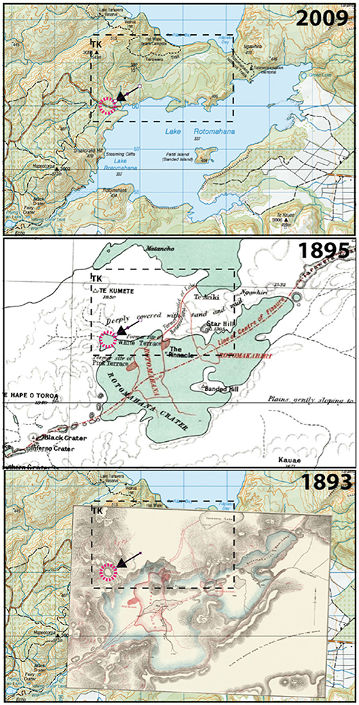
Figure 7. Historic topographic maps showing equivalent spatial area of southern Lake Tarawera, Lake Rotomahana and the Waimangu valley area, depicting the evolution of the Black Terrace Crater site since 1893. The 1893 map (Smith, 1894) shows Black Terrace Crater in a valley located off the northwest corner of Lake Rotomahana (dashed circle, with indicating arrow) that is carried through to the other maps. The 1895 map (from Cadell, 1897) contains pre-1886 eruption Lake Rotomahana outline, sinter terrace locations, and stream locations similar to what is shown in the 1893 map version. Dashed line inset is area covered by LIDAR shown in Supplementary Figure 1.
A view of Lake Rotomahana looking toward Mount Tarawera from Te Hape-O-Toroa Hill in 1893 from a lithograph gives yet another perspective about The Terraces, including the former Black Terrace location (Smith, 1894). A system of cross-hairs superimposed on that lithograph (Figure 8) guided by detailed descriptions (Smith, 1894) suggests the former Black Terrace was located southwest of the position indicated using Hochstetter's (1863) map (see Section Map Orientation and Scaling Using Station 21 and Puai Island Datums as Anchors Results; Figure 6). This alternative location (38.262353°S and 176.416095°E) was ascribed from a perspective generated from LIDAR (Figure 8), and it is south of where the Black Terrace Crater is drawn on a map from the same report (Smith, 1894). This finding lends to at least three potential solutions for The Black Terrace former site location (addressed further in the discussion).
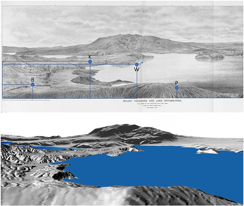
Figure 8. (Top) Lithograph from Smith (1894) “Mount Tarawera and Lake Rotomahana (the scene of the eruption, 10th June 1886) from Te Hape-O-Toroa Hill, 29th March, 1893” showing an oblique view capturing northeast-to-east vistas over the Rotomahana basin and hinterland (geographical north is to the left). A system of cross-hairs drawn on the lithograph are referred to in Smith's (1894) report that provide estimated locations for the Black Terrace (B), the Kaiwaka River outlet (K), the White Terrace (W), and the Pink Terrace (P). (Bottom) Digital elevation model perspective using LIDAR from Te-Hape-O-Toroa Hill from a similar vantage point as the lithograph, which was used to reconcile estimated locations for the Kaiwaka River outlet and the Terraces. Note, lake level is higher in this view than the late 1800s.
Discussion
Agreement and Divergence From Previous Work
Treatment of Hochstetter's Compass Bearings
We evaluated Hochstetter's (1859) field notes and compass bearings, dividing Lake Rotomahana's Station 21 data into two categories: landmarks positioned well outside of the former lake edge, and therefore could have survived the 1886 eruption, or features located around the lake fringe that were likely to have been partially or completely modified (or destroyed) by direct or associated impacts of volcanism. The same classification scheme was applied for other datums established en route to the lake. Hochstetter's bearings were corrected for 1859 local magnetic declination to align them to true north. A field sketch of Hochstetter's track en route to Lake Rotomahana provides basic locations for his former benchmarks. This sketch map is a metadata source that allows an additional correction for convergence angle to be ascribed and applied to those bearings, which is needed because of our choice to use Topo50 maps for this reconstruction. Convergence corrections are requisite for improving resection of datum from tabulated bearings, and particularly for verification using far afield landmarks (as with Putauaki/Mount Edgecumbe; see section Evaluating Hochstetter's Survey Datums).
The basis for our declination choices (Lake Rotomahana, 14.04°E; survey sites NW of the lake, 14.03°E) comes from IGRF12 model results for 1859. Results from this model for Auckland in the same year agree with published geomagnetic field survey tables that come from the scientific report of the “Novara.” Hochstetter took part in that magnetic survey, and he is mentioned by name in the first paragraph in the chapter on land-based magnetic measurements (Müller, 1862–1865). Replicated geomagnetic field measurements from the “Novara” (Supplementary Figure 7) are consistent with published Admiralty Declination charts of the mid-nineteenth century (Supplementary Figure 6). It would seem that Hochstetter, if he was so predisposed, would have been capable of accurate corrections to his magnetic bearings for declination of the day with resources at-hand and been able to achieve a similar result as we have for testing his bearings.
BN18 previously assessed two different magnetic declination corrections at Lake Rotomahana, including one termed “Revised Admiralty” (11.98°E; used) and IGRF (14.04°E; not used; see their Supplementary Figure 6). BN18 chose to use “Revised Admiralty” corrected bearings in combination with a tienstra equation and other corrections (stated as Lehmann's method, but not cited) to ascribe a location for Station 21 and Puai station datums. We find no basis for that choice of declination application or use of other ad hoc corrections presented by BN18 in light of reviewing the information that was on offer to Hochstetter. Recent updates to BN18 (Bunn et al., 2018) have continued to use a modified declination correction that is different from that in BN18, but which is still not consistent with the IGRF model.
Beyond the main point of difference for declination correction, there are other assertions BN18 made about landmark locations in addition to selective corrections applied to Hochstetter's primary data. Some choices were pragmatic and based on post-eruption eyewitness accounts for landscape changes (e.g., the possible location of Tarawera summit). In our study, we also identified similar issues with Hochstetter's field notes containing potential errors (e.g., a few bearings not lining up to some of the features for either map version, or some not aligning to a common datum). However, that should not be interpreted as a critique of Hochstetter's survey. Rather, the assertions and choices of BN18 for selecting origins of many landmarks follow on from a declination correction that was too low. Decisions of this type made by any researcher would only amplify any differences from the results presented in our study.
Evaluating Hochstetter's Survey Datums
Spatial density plots of back bearing intersections allowed us to ascribe locations for Hochstetter's (1859) datums leading up to and at Lake Rotomahana. The approach we employed used a conservative error estimate (+/−0.50 degrees) applied to non-adjustable compass measurements recorded at ten-minute intervals. This error has a basis in instrument precision, accounting for palaeo-declination correction, and grid north-true north offset (convergence angle) correction. Collective error estimates and bearing corrections are requisite for plotting Hochstetter's bearings over NZ Topo maps, which use a cartographic projection that is equidistant in both the X and Y planes.
Back bearings from multiple landmarks produced intersections that show possible locations for Hochstetter's survey datums (Figure 5). Tight clustering of intersections, cataloged in 50 m2 grid cells, were further assessed with LIDAR data. This approach allowed us to examine physical traits of small areas with the greatest density of back bearing intersections and to ascribe locations for Stations 18–20. Hochstetter's survey sites correspond to small knolls or shelves along north-facing hillslopes at >450 m elevation. These vantage points, often situated up to and exceeding 100 m above surrounding lakes and valleys, gave him wide views across the Rotorua landscape.
Hochstetter's bearings to distant landforms (>25 km away) that we initially excluded support the efficacy of our survey datum reconstructions based only on high quality landmarks. All bearings shot to Putauaki (a nearly-symmetric cone) from coordinates we established for his datums appear reasonable; they flank or bisect that volcanic landform as Hochstetter stated they should (Table 1). Bearings to Putauaki's center from Station 18, 19, and 20 align to the middle of that landform (near the summit) and within the range of expected compass and convergence angle error (Supplementary Figure 9). Additional bearings along the sides of Putauaki from Station 18 and 19 overlap (within bearing error margins) for the northern flank of that volcano, and are close to overlapping along the southern margin. Other sites >25 km away that Hochstetter surveyed include a high point on Pukeahua (spelled “Puke Hue”) from Station 18. The margin of error for bearings shot to these landmarks are located within tens of meters of the target Hochstetter intended to hit.
Hochstetter also produced a detailed watercolor landscape painting that illustrated the profile of Mount Tarawera from Station 20 (Figure 9). It compares favorably to a DEM profile for the modern Tarawera mountainside taken from the location we identified as Station 20, which supports our datum resection results. Stations 18 and 19 bearings were also accompanied by a rudimentary Mount Tarawera profile and bearings to topographic slope break points. When we project those bearings out from reconstructed datum locations, they flank Mount Tarawera with reasonable accuracy.
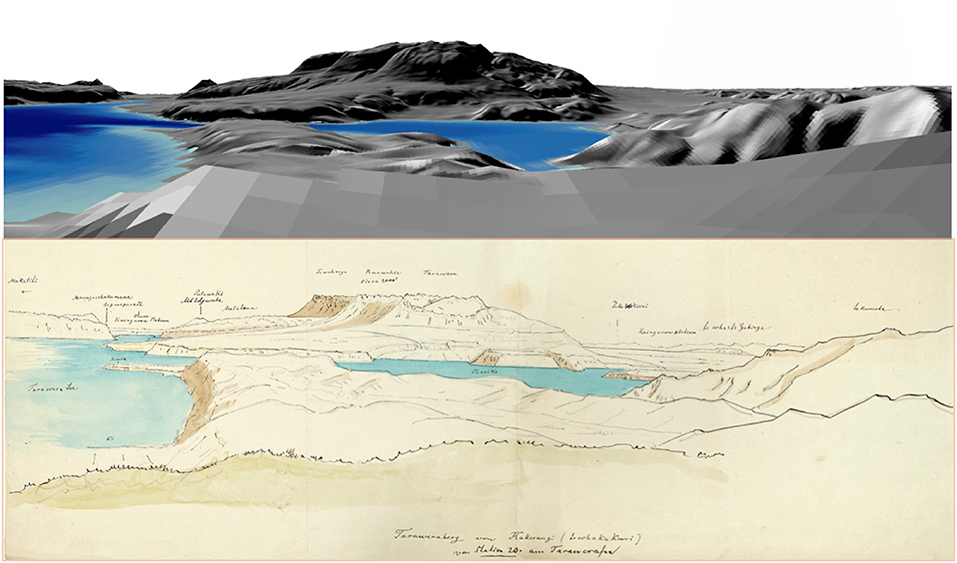
Figure 9. (Top) Digital elevation oblique view of Mount Tarawera and the surrounding landscape near Lake Tarawera from the reconstructed position for Station 20 based on Hochstetter's (1859) survey notes showing an oblique view capturing northeast-to-southeast vistas over Lake Tarawera (geographical north is to the left). (Bottom) Watercolor and pencil sketch of the same view from Station 20 as crafted by Ferdinand von Hochstetter April 1859 (modified from Nolden and Nolden, 2013). Volcanic peaks of Maungawhakamana, Putauaki (Mount Edgecumbe) and Mount Tarawera (noting domes Te Wahanga, Ruawahia, Tarawera) along with other landmarks are noted in the watercolor.
The Makatiti Dome focal point was independently defined from mutual intersection of bearings from Station 18 and 19, which are well outside of pre-1886 Lake Rotomahana boundaries. Bearing convergence from that point on Makatiti Dome with Te Kumete highest point and a secondary high point (Peak D) on Te Kumete ridge provides a tightly constrained location for Station 21. Selection of the two latter high points was supported by LIDAR. Points of origin for several other lower quality reciprocal bearings from Te Kumete ridge were assessed from this constrained location (Supplementary Figure 5) and we demonstrate they converge close to the spot (within the error bounds) of the three high quality survey bearings. This elevates confidence for Station 21 being located within the middle part of eastern (modern) Lake Rotomahana (Figure 6; Table 3).
Evaluating Hochstetter's Mapping Accuracy and Precision for Rotomahana
Compass bearings shot to former geothermal and volcanic landforms around former Lake Rotomahana allowed us to assess accuracy and precision for Hochstetter's watercolor (Hochstetter, 1859; version with thermal details) and published (1863) maps. Hochstetter's bearings (Supplementary Figure 2; Table 1) plotted over the 1863 map (Supplementary Figure 8A) indicate that geothermal and volcanic features are positioned from a datum relative to magnetic north (also identified by Bunn, 2016). The 1863 map is internally consistent with field survey data, but the 1859 watercolor used by BN18 does not have the same level of consistency. Only when bearings are corrected for magnetic declination (relative to true north) do some features in the 1859 watercolor align to field bearings. Well-demarcated hot springs along the northern (Te Mamaku) and eastern lake shore perimeter (Ngahapu, Te Takapo, Ruakiwi, Ngawhana, Whakaehu) were internally consistent when a declination correction is applied to Hochstetter's bearings. However, five geothermal landmarks (including main geothermal features of Te Tarata and Te Otukapuarangi) did not align to corrected bearings. This misalignment suggests use of the 1859 watercolor map for locating the former sites of the Terraces is compromised.
Keir (2017) assessed bearings for a portion of Hochstetter's watercolor map, but achieved slightly different results from those we have presented here. Bearings in Keir's study were rounded to the nearest whole number and a blanket convergence angle correction of 2° was applied, which is different from the correction we used (2.12°) at Rotomahana. Together with manual plotting of bearings, Keir (2017) may have attained a different level of plotting precision relative to our work. Nevertheless, assertions made by Keir (2017) that some of Hochstetter's bearings did not align to features in the 1859 watercolor are upheld; however, no evaluation of the external bearings was undertaken. Our work has done that task using data from Rotomahana and several other stations. Resection of Hochstetter's datums shows he made accurate compass measurements.
While some features shown on Hochstetter's (1859) watercolor may not be able to be precisely positioned using Station 21 bearings, cartographic sources like it could be valuable for refining the geomorphology around the former lake. In fact, some sinter formations seen in a different watercolor iteration by Hochstetter (Figure 10) can be reconciled in photographs, but not in published versions of the pre-1886 Rotomahana map. This is particularly evident near the toe slope of Te Tarata where shallow sinter formations were aligned parallel to the former Lake Rotomahana shore (Figure 10). As such, Hochstetter's watercolor maps can demarcate relative positions of former geothermal features (i.e., sinter is north of, east of, downstream of, etc.) and they provide a powerful complement and counterpart to limited historic photographic evidence.
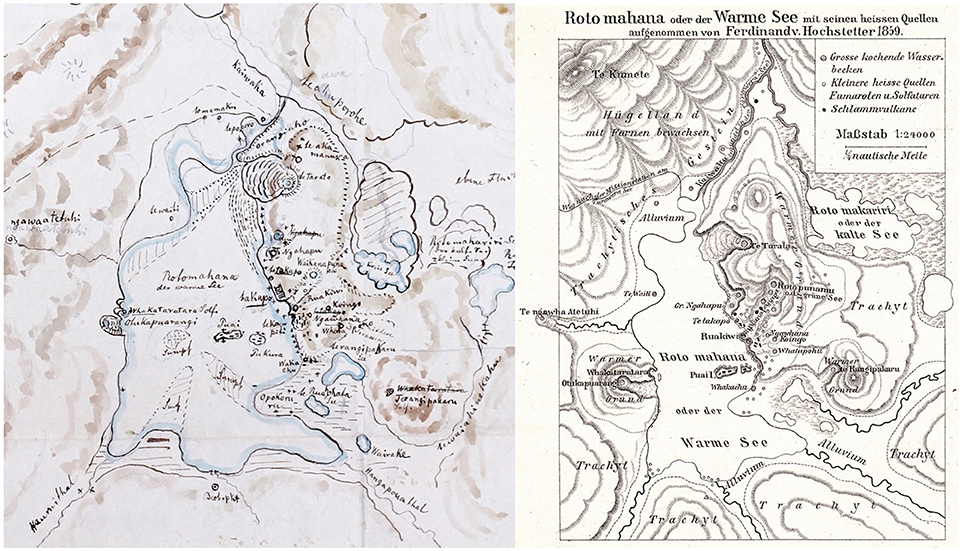
Figure 10. (Left) Skizze des Rotomahana den 29 April F.H. Watercolor, ink and pencil on paper (extracted and magnified from plate 3.5.4 in Nolden and Nolden, 2013) showing Lake Rotomahana in 1859 as sketched by Hochstetter. This rendition shows labels for main sinter terrace and geothermal features similar to the other 1859 watercolor (dated 30 April 1859; Figure 3). Temperature measurements and details of many springs and sinter formations along the Kaiwaka River are absent on this watercolor version, however it contains details for swamp areas, lakes, and sub-linear shallow relief sinter formations along the toe slope of Te Tarata not seen in the other watercolor or the published map. (Right) “Rotomahana oder der Warme See mit seinen heissen Quellen aufgenommen von Ferdinand v. Hochstetter 1859,” which is slightly modified relative to the Justus Perthes of Gotha versions produced in 1862–65 (Figure 3). This map is contained in one of Hochsetter's last contributions (Hochstetter, 1882). Labels for many of the minor springs (particularly along the northern edge of the lake and in the Kaiwaka River valley) and small lakes east of Rotomahana and Rotomakariri were removed on this last version.
One consideration is that Hochstetter's (1859) watercolor maps may represent work-in-progress, constituting an incomplete transformation of his survey data to a projection that accounted for declination and with proportional scales for a wide range of landforms. We observe from Hochstetter's field notes and sketches that there was a process of cartographic progression that involved continued improvement, refinement, and simplification of landscape depiction through iterative map making (Figure 10). He reconsidered how to draw certain objects located far from his survey datums even within the same map iteration (e.g., scale and orientation of Lake Rotomakariri sketched on the 1859 thermal detail map; see Figure 3B). Hochstetter also progressively simplified the Rotomahana map well after the first official version of it was published. Evidence of this process is shown in a similar iteration as the 1863 map that was used in one of Hochstetter's last publications on Rotomahana that depicts only basic labels for many ngāwhās (thermal springs), puias (geysers), mud pools and geothermal features (Figure 10; Hochstetter, 1882).
Validation of the Map Orientation, Scale, and Suggested Location of the Terraces
Former locations for Station 21 and Puai Island datums provide anchors for orientation and scaling of Hochstetter's map in this study. BN18 indicated that the Puai Island survey site may have been positioned on the western end of the island because of a wide range of unimpeded views. We recognize that assertion as being valid, but also consider the northern side of Puai Island would have provided unimpeded views to many of Lake Rotomahana's geothermal landmarks. Based on the Station 21 datum location and that of Puai Island, a projection for the 1863 map (orientation and scaling) that satisfied Hochstetter's data (see section Results) gave a datum position on the northeast side of Puai Island. High points there can be seen in several historic photographs, including a barren, flat platform that existed when Hochstetter journeyed to Lake Rotomahana (Figure 11; photo from Bruno Hamel 2.7.22 in Nolden and Nolden, 2013). More important, our scaling using the northeast end of Puai as the datum location produces a result that is consistent with the linear bar scale on the 1863 map (1/4 nautical mile = 468 m; Figure 6). We note that when the 1863 map is orientated and scaled according to our study, there is a parallel alignment of the former Waikanapanapa and Te Rangipakaru solfatara sinter terraces with the main 1886 rift trace (Smith, 1886, 1894) that connects the northeast end of modern Lake Rotomahana to Haumi Stream at the mouth of Waimangu Valley.
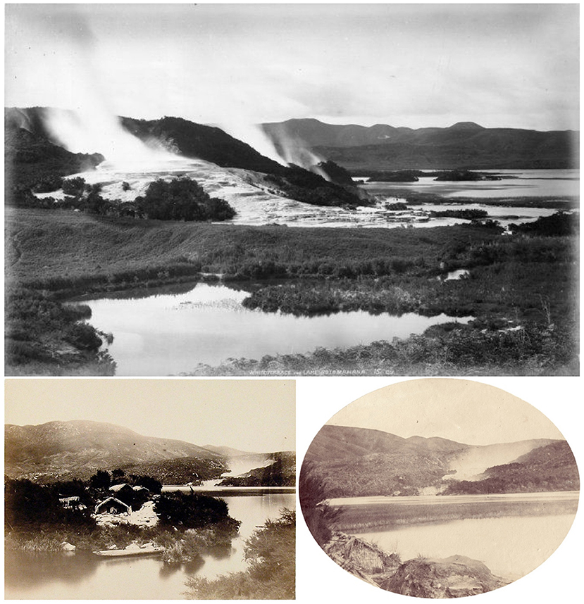
Figure 11. (Top) Photograph “White Terraces and Lake Rotomahana” by George Dobson Valentine (1852–1890) prior to the 1886 Mount Tarawera eruption with a view toward Te Tarata. It shows the narrow gap between Pukura (left) and Puai (right) islands in the distance. Vantage point for this photograph was likely the northern escarpment of the Kaiwaka River looking south across the lake (see Supplementary Table 1). (Bottom, left) Photograph “Puai Island from Pukura Island, Rotomahana. Te Hapeotoroa Mountain and Otukapuarangi beyond” by John Kinder (1819–1903), which shows a narrow gap between the two islands. The waka (canoe) and the person sitting in front of the whare (house) suggest a scale of about 10–15 meters between the islands. An elevated platform on the NE end of the island can be seen to the right of that house. (Bottom, right) Photograph “Neu-Seeland, Prov. Auckland. Otukapuarangi am Rotomahana” mounted with caption by Hochstetter (item 2.7.21 in Nolden and Nolden, 2012) taken by Bruno Lancel Hamel, showing a high, flat platform on the northeast end of Puai Island. This spot, in addition to where this photograph was taken from, could have provided vistas on the northeast end of Puai Island for a compass bearing survey. Photographs used with permission from the Alexander Turnbull Library, Otago University Research Heritage (Hocken Library), and Sascha Nolden, respectively. Both photographs that include Puai Island show views that are looking toward the western lake shoreline.
Several landforms and geothermal features seen on 1863 map support the efficacy of our geolocation, scaling and orientation of Lake Rotomahana depicted in that document. First, the length of Waikanapanapa valley on the 1863 map is validated by Hochstetter's account (stated as about ¼ mile long; Hochstetter, 1867; see Supplementary Text). Second, early photographs show the gap between Puai Island and Pukura Island was narrow (Figure 11). Separation between Puai and Pukura on Hochstetter's (1863) map, as scaled in our study, suggests a distance of about 12–15 m (40–50 feet) between the islands. Third, the width and length of Puai sketched by Hochstetter is consistent with dimensions he mentioned in his writings (250' (~76 m) and 100' (~30 m), respectively; see Supplementary Text). Last, the dimensions and orientation of the Pink and White Terraces using the projection and scaling made in our study appear consistent with Hochstetter's accounts (Hochstetter, 1864, 1867).
BN18 applied spatial distortion techniques to the 1859 watercolor map via stretching and shearing the main map axes in that historic document. We do not address that issue here, because we have elected the 1863 map instead of the 1859 map as a superior cartographic product. However, we emphasize that results offered in our study have not relied on alteration of any of Hochstetter's primary survey data, and we did not distort the map when it was placed into modern cartographic space (Figure 6).
The former locations of the Pink and White Terraces (Figure 2), using Hochstetter's resected datums and 1863 map, are entirely situated within the confines of modern Lake Rotomahana. The Pink Terrace is located close to where other investigators have placed it, and this location is hemmed in by volcanic ridges where current hydrothermal activity exists (de Ronde et al., 2016b). The location and orientation of the Pink Terrace we have ascribed nests that former site within a subtly reduced region of heat flux (Tivey et al., 2016) relative to elevated values in the Pink Terrace hydrothermal system. Both the Pink and White Terrace former site locations we identified, via orientating and scaling the 1863 map, are very close to remains of sinter terrace seen in underwater camera footage (de Ronde et al., 2016a). The White Terrace location is situated west of “Pinnacle Ridge” on the 1863 map. We also note that bubble plume presence (de Ronde et al., 2016b) circumscribes a large part of the western and southern perimeter of the former lake margin according to our orientation and scaling of the 1863 map (Figure 12). There is a SW-NE orientated gap in the bubble plume field where Haumi Stream was formerly located. The orientation of sinter terrace features such as Waikanapanapa and Te Rangipakaru solfatara sinter terraces align to 057°-237° (the same as the main Tarawera Rift trace), while the northern and southern bounds of the White Terrace align with en echelon basalt dikes orientated at 072°-252° (de Ronde et al., 2016b).
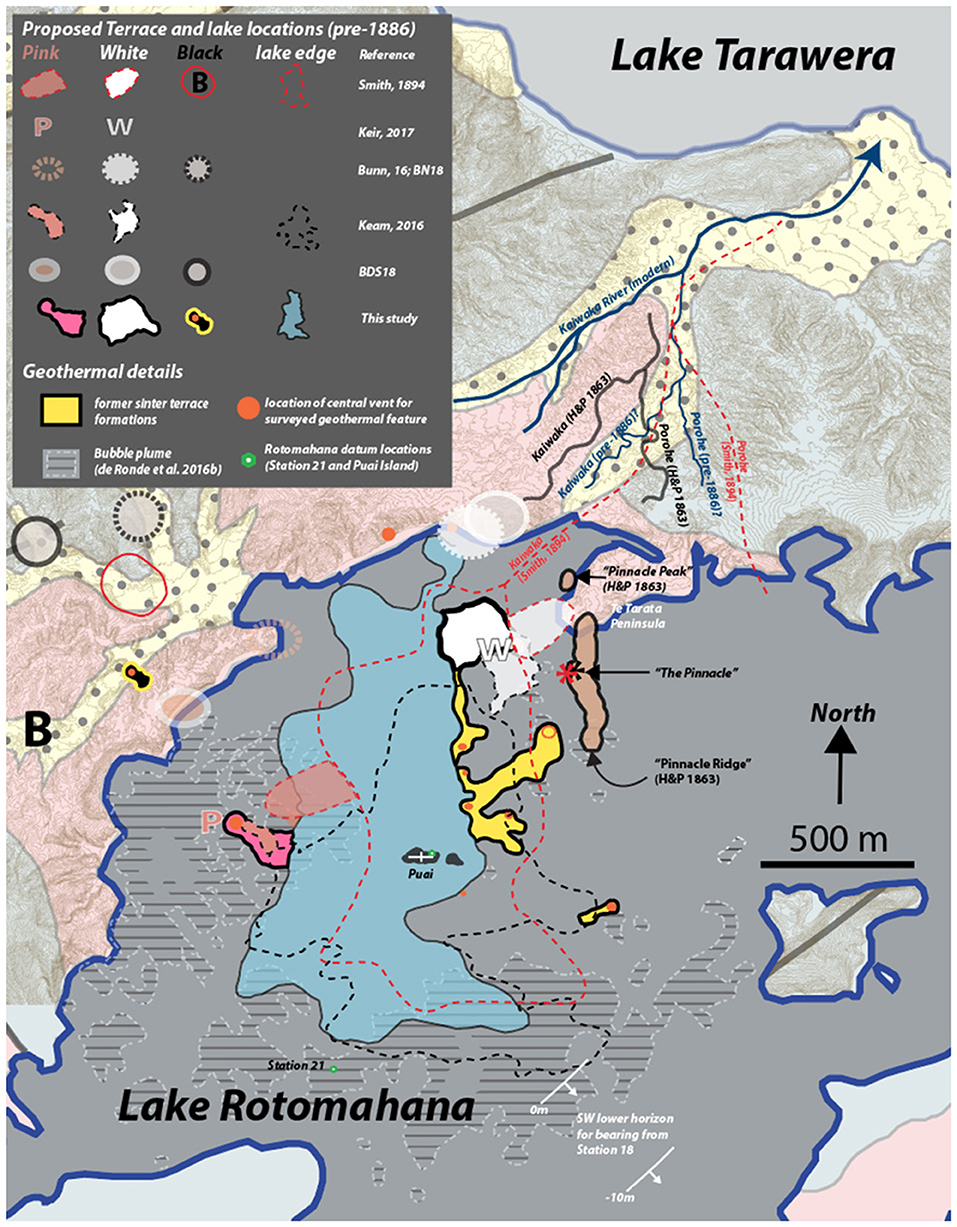
Figure 12. Projection of Lake Rotomahana (blue shaded) based on the 1863 Justus Perthes of Gotha map positioned, orientated and scaled according to reconstruction of Hochstetter's 1859 survey. Locations for the terraces and geothermal features sighted by Hochstetter in Supplementary Table 1 are plotted alongside other estimated locations for former stream and river positions, lake margins and the locations for the Pink, White and Black Terraces. Keam (2016) features are adjusted positions based on de Ronde et al. (2018). Geologic formations on land correspond to Figure 1, and bubble plume outline is from de Ronde et al. (2016b). LIDAR overlay has a 2 m contour. Thin blue lines for pre-1886 Kaiwaka and Te Awa Porohe follow LIDAR channels (best estimate position).
Based on our results, “The Pinnacle” post-eruption fumarole feature (Smith, 1894) intersects the “Pinnacle Ridge” feature seen on the 1863 map (Figure 12). “The Pinnacle” post-eruption feature is located between and above where Waikanapanapa valley and Te Tarata were located (in a place previously suggested by others; de Ronde et al., 2016a; Keam, 2016). In addition, the distance of “The Pinnacle” from the location of the Black Terrace Crater and the Black Terrace is congruent with field measurements after the eruption (Smith, 1886), despite uncertainty as to whether or not those two sites are one in the same. The spatial scale and orientation of the 1863 map places “Pinnacle Peak”—a high topographic feature that is observed in many historic photographs—just north of Te Tarata Peninsula on the edge of a prominent bay. A spring called Te Aka Manuka that was embedded in the hillside north of “Pinnacle Peak,” along with several other aligned hot springs/vents just to the northeast, lie within the bay north of Te Tarata Peninsula (Figure 12). Again, positions of these features are highly dependent on the cartography in the 1863 map, and perhaps “Pinnacle Peak” was located just a bit further south (and possibly aligned over Te Tarata Peninsula). Interpretations we can assert from this observation based on our study suggest explosive energy released along the Te Aka Manuka vent line during the 1886 eruption may have catastrophically decapitated part of “Pinnacle Ridge” and “Pinnacle Peak” above and to the east of Te Tarata. If a collapse of that peak and ridge occurred, it could have contributed to the ruin (and/or destruction) of the White Terrace situated below. This hypothesis expands on and agrees with recent thoughts about how “Pinnacle Ridge” and subsequent exposure of “The Pinnacle” may have evolved and emerged from the 1886 eruption (see de Ronde et al., 2018).
Photographic comparisons undertaken by Keir (2017) were used to reject assertions of BN18 based on the 1859 watercolor map. Although photogrammetry has also been employed for re-evaluating pre-1886 Lake Rotomahana features using historic photos (Keam, 2016), the techniques and methods applied in some of that work have not been clearly stated in the literature. We cannot gauge how much distortion may exist in older photographic evidence and therefore what related alignment error is inherent to those results. As such, we do not draw on that evidence here, but recognize its corroboration value and note that it can be compared with our findings in the future (and possibly refine the results offered here). We recognize Keam's (2016 and other references there in) long-term efforts to refine the former Lake Rotomahana boundaries using photographs, and find support for his assertions that parts of the former lake may have extended east of where it is depicted on the 1863 map. A single bearing from Station 18 suggests Hochstetter sighted Rotomahana through a slot within intervening hills (Table 1). When this bearing is plotted over LIDAR, the western most point for Rotomahana he could have seen (based on today's lake level) lies just to the east of where all of the reconstructed southeastern lake boundaries are presently marked (Figure 12). A lower lake level by 10 m would have limited that field of view of the lake by up to 400 m (and so on, if the former lake surface was at lower altitude). If it really was Lake Rotomahana rather than the swamp/basin next to it that Hochstetter sighted from Station 18, the implications are that his field of view for distant landmarks he drew and mapped at Rotomahana may have been distorted due to lack of relative scale. Alternatively, the cartography may have intentionally condensed the wider landscape around a more spatially accurate view of Rotomahana as a page size accommodation tactic. We feel the former perspective is more realistic. Renewed efforts using old photographs with modern photogrammetry approaches and Hochstetter's historic surveys to reconstruct the pre-1886 Rotomahana landscape, building on Keam's (2016) efforts, clearly deserve further attention and can help address these outstanding issues.
The Black Terrace was not surveyed from any of Hochstetter's Rotomahana datums, but is depicted northwest of the Pink Terrace up a valley away from the lake (Figure 7). Historic maps indicate the Black Terrace Crater was in a valley extending off the northwest corner of Lake Rotomahana (Figure 7), not far from where BN18 estimated the position for the Black Terrace. Maps from 1893 to 1895 suggest Lake Rotomahana expanded rapidly in the post eruption period, and water may have been over the Black Terrace Crater. Then after half a century elapsed, alluvial sedimentation had in-filled the valley floor and obscured any features it contained. From this evidence, we cannot discern whether the Black Terrace and the Black Terrace Crater were the same feature, and we cannot identify any historic photographs for these features either. At the very least, the valley widths and forestry roads on the western side of Lake Rotomahana suggests a crater (and/or terrace) of considerable size could be accommodated at several locations. Geomorphic interpretations of LIDAR indicate former crater rim may be preserved adjacent to the Black Terrace Crater site. Nevertheless, it is debatable whether the Black Terrace Crater and the Black Terrace were distinct features located in close proximity, or whether the Black Terrace Crater was created as a result of the Black Terrace erupting. All the evidence suggests the former Black Terrace site was on land off of the northwest corner of modern Lake Rotomahana, supporting Hochstetter's general placement of that feature on his 1863 map, details in Smith (1894), and assertions of BN18 (despite their use of a different map and method).
While post-eruption oblique views of Rotomahana (like the one in Figure 8) have tried to incorporate estimated positions for The Terraces, remarks from parties that surveyed the destruction place caveats on those assertions.
“The whole configuration of the place was so completely altered, that those who were most familiar with its features hesitated in locating the site of the Pink Terrace.” (Leys, 1887).
This statement could be equally applicable to the Black Terrace, and locations estimated for the other terraces based on eyewitness accounts after the eruption.
Reconciling the Margins of Hochstetter's Maps With Modern Geomorphology
Fluvial and lacustrine features on the 1863 map outside of former Lake Rotomahana unsatisfactorily align to modern geomorphic indicators shown in LIDAR, based on the orientation and scaling we provided in this study. We recognize that the former Kaiwaka River channel may not be depicted in the correct location in historic post-eruption maps (Smith, 1894; Cadell, 1897). In addition, Te Awa Porohe (The Porohe River) in the 1859 and 1863 maps (Figures 3, 10) may also not be in the correct position, drawn to the correct scale, or orientated correctly. Taken at face value, however, the most obvious discrepancies are relative positions for the former Kaiwaka River (including the junction with Te Awa Porohe) and the orientation and position of Lake Rotomakariri. Field observations from post-eruption surveys state the former Kaiwaka River channel was completely plugged (Smith, 1886, 1887, 1894). This view is consistent with recorded depths for volcanic products overlying the area north of modern lake (Pittari et al., 2016), which greatly altered the Lake Rotomahana outlet and the Kaiwaka River geomorphology down to Lake Tarawera.
Further evidence for altered fluvial and lacustrine features, which are depicted at the map margins, are observed in the Kaiwaka River catchment north of Lake Rotomahana. Two prominent fan deltas currently exist in the southern Te Ariki arm of Lake Tarawera, but oblique photography from 1886 shows a very different post-eruption landscape. In 1886, there was a lake-edge scarp fronted by a fan delta at the former Kaiwaka River outlet (Supplementary Figure 10). The shoreline shift for Lake Tarawera and clear lake-edge progradation since 1886 demonstrates that the former Kaiwaka River rapidly changed. From LIDAR, there is no ground surface signature of the pre-eruption lake shoreline or the post-1886 delta. This supports the notion that, initially, Lake Tarawera was lower than what is seen in photographs taken just after the eruption (Supplementary Figure 10), and it rose after that event. Notes from the meteorological register from Rotorua corroborate this change, documenting rapid local base level rise of +18 inches at Lake Rotorua after the 10 June 1886 eruption (Supplementary Figure 11). Continuation of that trend for other lakes nearby (such as Lake Tarawera) may have meant the pre-eruption Kaiwaka outlet of 1886 was buried beneath alluvium from local base level being raised rapidly. Therefore, the palaeo-delta for the Kaiwaka river may be situated a few hundred meters inland from the present river mouth (see LIDAR in Supplementary Figure 1). Upstream, the Kaiwaka River channel, and major branches off of it, would have responded to base level changes and an excessive sediment supply.
The former Lake Rotomahana outlet and Kaiwaka channel as mapped by Smith (1894) are positioned partly over a prominent fluvial incision into tephra and alluvium (seen in LIDAR north of Te Tarata Peninsula; Figure 7, 12; Supplementary Figure 1). The position for Te Awa Porohe, based on the same report, unrealistically aligns to high ground. 2018; their Supplementary Figure Bunn and Nolden (9) placed Te Awa Porohe over where Smith (1894) suggested the former Kaiwaka channel flowed, and they also suggested the former Kaiwaka River aligned to where the modern Kaiwaka course is located, based on their rectification of the 1859 watercolor map. The location of the former Kaiwaka River channel based on our orientation and scaling of the 1863 map is situated close to where Smith (1894) positioned it, and aligns with the location indicated by Smith (1894) in an oblique view from Te-Hape-o-Toroa Hill (Figure 8).
The Kaiwaka River and Te Awa Porohe geomorphology in the 1863 map, including (a) the shape of their junction, (b) funneling into rapids, and (c) a dog-leg turn to the north after the junction, agrees best with LIDAR features seen ~100 m to the southeast of where our scaling and orientation of the 1863 map positions both rivers (Figure 12). It is likely part of the relic Kaiwaka River downstream from Rotomahana is located just west of the narrow constriction leading onto Te Tarata Peninsula, with part of the former Te Awa Porohe channel located to the east (Figure 12). This interpretation fits with conventional understanding of contemporary lake bathymetry that suggests Star Hill crater and other subaqueous craters to the east of Te Tarata Peninsula overlie the former Lake Rotomakariri basin (de Ronde et al., 2016b).
Changes in the Lake Tarawera/Kaiwaka/Rotomahana Basin mentioned above may have averted the Kaiwaka River from its former main northeast-flowing channel (plugged with tephra) to occupy a more northerly branch after the 1886 eruption. This point supports the assertion that, for the most part, former Lake Rotomahana geothermal features in Hochstetter's (1863) map have factually-based spatial constraints in the cartography. However, the depth of field that dictated their exact position on the 1863 map may require a re-evaluation (i.e., they might slide closer to or away from the survey datums). In addition, geothermal features and landforms farther away from Hochstetter's survey datums (e.g., the Black Terrace, Tamariwi, Rangipakaru), parts of the lake margin (the southeast arm of the former lake), fluvial channels and lacustrine bodies (e.g., Rotomakariri, orientation of the Kaiwaka River) that are seen at the map edges may be subject to potential revision. Notwithstanding, the fluvial geomorphic signatures we have identified in the LIDAR and linked to the 1863 map indicate the former location of the White Terrace as asserted by BN18 (and subsequently in Bunn et al., 2018) is positioned on the wrong side of the relict Kaiwaka River. This is yet another reason to reject assertions that the White Terrace is positioned on land north of the modern Lake Rotomahana shoreline.
Summary
We have demonstrated how combining historic survey and cartographic resources with contemporary geological data can help reconstruct New Zealand early historic volcanic landscapes. Our work builds on previous efforts that have re-evaluated Ferdinand von Hochstetter's historic survey data as they have become available (Supplementary Figures 1–3). A wider set of compass bearings than previously employed (Bunn, 2016 and subsequent studies) and objective evaluation of Hochstetter's survey landmarks allowed several datum locations to be reconstructed (Figures 4, 7). The declination correction we applied to Hochstetter's bearings conforms with internationally distributed admiralty charts (Supplementary Figure 6) and the IGRF12 declination model. Declination for 1859 was corroborated by historic magnetic measurements taken by Hochstetter's expedition party in Auckland (Supplementary Figure 7). Use of Hochstetter's compass bearings with contemporary New Zealand topographic maps required an iterative convergence angle correction to account for survey stations spaced west-to-east across the landscape (Figure 4). Landmarks that were shared between different survey datums (Tables 1, 2) provided a common solution for Hochstetter's wider compass survey dataset, and they show that his bearings were accurate (within +/−0.50 degrees) relative to mid-nineteenth century equipment he employed.
Application of LIDAR with Hochstetter's survey data (Figure 5) helped to evaluate the realism for reconstructions of his former datum locations (Supplementary Figure 5), including survey sight lines, landscape profiles, and landforms that he viewed in 1859. Detailed perspectives that Hochstetter painted or sketched, when compared with oblique near-ground 3-D digital elevation model perspectives (Figure 9), verify locations we identified for Stations 20 and 21. Independent verification of some former datum locations was undertaken by sighting landforms >25 km away that were held out of the initial reconstructions (Supplementary Figure 9). In addition, use of bearings with stronger confidence to identify a datum location, then shooting bearings to landmarks with poor location metadata from those datum, provides a way to find sites that are presently not labeled in the modern cartography (Supplementary Table 1). In essence, this process allowed us to serendipitously locate sites mentioned by Hochstetter that were surveyed from Stations 18-20 that were formerly located along Lake Tarawera (Figure 4), but were drowned by rising lake levels after 1886 (see Table 2).
The choice of Hochstetter's map (Figure 3) for evaluating where former sites of the Terraces are located is a critical part of this re-evaluation. Our map choice was guided by an internal precision test (Supplementary Figure 8), which shows the 1863 version published by Justus Perthes of Gotha is internally consistent with the survey data contained in Hochstetter's diary (Table 2). The 1859 watercolor map (thermal detail version used by Bunn, 2016; BN18) is not internally consistent with the survey bearings, and therefore it does not accurately indicate how sinter terraces and geothermal features around Lake Rotomahana were juxtaposed prior to 1886. There is evidence from the series of maps Hochstetter made for Lake Rotomahana that shows cartographic progression (Figure 10). Suggestions that can be made from Hochstetter's map sequence would imply the watercolor versions were initial drafts generated ahead of published versions. We conclude the 1859 watercolor map (employed by BN18) is contained within a series Hochstetter crafted prior to a final version being professionally printed. As such, the assertions that Hochstetter's (1859) watercolor map (thermal detail version) is a superior cartographic product relative to the 1863 published map (Bunn, 2016 and references after), and application of that 1859 map to locate former Terrace sites, are untenable. We temper these points by suggesting that the 1863 map has known issues that others have attempted to reconcile using photographs (Keam, 2016), and that dramatic environmental changes since the eruption (Supplementary Figure 10) make some reconciliations with the current landscape difficult.
New outcomes for Hochstetter's datum locations at Lake Rotomahana and on Puai Island are provided in this study. Using those two datums as anchors produced a projection for the 1863 map that depicts geothermal features and landforms within the former Rotomahana environment (Table 3). The geothermal feature arrangement (e.g., sinter terraces, springs, length and orientation of The Terraces and Waikanapanapa valley, length and width of Puai Island) conforms with Hochstetter's detailed descriptions, bearings and photographic evidence (Figure 11). The 1863 map orientation and associated scale, based on the anchoring datum coordinates, is consistent with the published scale on that map (1/4 nautical mile). Spatial evidence contained in historic photographs that capture landmarks at the former lake supports placement, orientation and scaling for the 1863 map in our study; however, features on the 1863 map at the margins, as well as landscape elements that were not included in Hochstetter's survey, may be subject to repositioning using other approaches.
Based on our positioning and orientation of Hochstetter's (1863) map, former locations for Te Tarata (The White Terrace) and Te Otukapuarangi (the Pink Terrace) are located well within the confines of modern Lake Rotomahana. This finding is consistent with three other (independent) published studies (Smith, 1894; Keam, 2016 and references there in; Keir, 2017) that suggested those two former terrace sites are located within the bounds of the modern lake (Figures 8, 12). Our locations for the former Pink and White Terraces sites and lake margin outline derived from the 1863 map are congruent with evidence (including proposed locations of sinter terrace remains within the lake) from recent Rotomahana investigations (see section Reconciling the Margins of Hochstetter's Maps With Modern Geomorphology). We suggest additional links can be made between relict physical geography and post-eruption geological evidence for Rotomahana.
Te Ngāwhā a Te Tuhi (Tuhi's spring; potentially the Black Terrace) former location is likely on land (Figure 7), as originally asserted by Smith (1894). However, that site may have been converted to a crater (the Black Terrace Crater) during/after the 1886 Tarawera eruption. At least three potential locations for the Black Terrace (and one for the Black Terrace Crater) are identified along or near forestry roads west of Lake Rotomahana (Figure 12). A range of geophysical investigations in that area may be able to detect if features related to the Black Terrace (or crater) are present or not. That effort may help to constrain the northwest corner of the former Lake Rotomahana environment, and better connect modern maps and older cartography with former terrace features.
Conclusions
Future application of modern, computer-guided photogrammetric methods (e.g., Structure from Motion; Vargo et al., 2017), paired with LIDAR and legacy cartography of Ferdinand von Hochstetter, could help update and improve previous work that harnessed early historic photographs to define the former Pink and White Terraces and pre-1886 Lake Rotomahana landscape (Figure 2; e.g., Keam, 2016 and references therein). Renewed effort on this front could enhance understanding of recent volcanism, and better constrain new search areas for evidence of small sinter terraces, geothermal springs, and landforms in the former Kaiwaka river valley (including Te Awa Porohe confluence) that may be preserved under tephra and reworked alluvium. In addition, the identification of former settlement locations using Hochstetter's bearings and notes (Table 1) is an important part of revitalizing regional history and the historic Terraces tourist route. Future research focused in this area is highly relevant for Thourangi hapu and their expression of tino rangatiratanga (self-determination), their identification and protection of culturally significant sites), and their responsibilities as kaitiaki (guardians; Tūhourangi Tribal Authority, 2011). The wider relevance of approaches that are demonstrated in our work are also applicable to the reconstruction of socio-environmental histories across cultural landscapes of importance to Māori—and potentially in other places where indigenous cultures have strong linkages to volcanic ecosystems.
Author Contributions
AL and J-MW worked on the data analyses together. AL wrote the manuscript and drafted the figures with input from J-MW. J-MW generated geologic maps, all digital elevation profiles and oblique digital landscape perspectives.
Conflict of Interest Statement
The authors declare that the research was conducted in the absence of any commercial or financial relationships that could be construed as a potential conflict of interest.
Acknowledgments
This work is possible via permissions and generosity of the Thourangi Tribal Authority (TTA). We extend our gratitude and respect to them as kaitiakitanga for Lake Rotomahana and for connecting us with their whenua. We thank the TTA for the hospitality during our fieldwork, and notably for their guidance in maintaining a positive wairua that has allowed our ropu to conduct this work. Special thanks are due to Sascha Nolden (Alexander Turnbull Library) and Sandy Nolden for supplying crucial reference material related to Ferdinand von Hochstetter, and especially to Sascha for supporting many discussions that improved the quality of this paper. Alan Skipwith, Rangitihi Pene, Nigel Veale, Phil White, Anne Mortimer, Ngarepo Eparaima, and Shayne Gibbons are all thanked for stimulating discussion around this work. Dr. Rob Allan at the UK Met Office in his capacity as the International ACRE initiative manager is thanked for supplying the scans of the published Novara scientific volume. Helen Bostock and Erica Williams (NIWA) are thanked for constructive comments that improved the manuscript, as are David J. Lowe (University of Waikato), and an reviewer and review editor for Frontiers in Earth Science.
Supplementary Material
The Supplementary Material for this article can be found online at: https://www.frontiersin.org/articles/10.3389/feart.2018.00205/full#supplementary-material
References
Bunn, A. R. (2016). Quest for the Pink and White Terraces: The Expedition to Recover New Zealand's Eighth Wonder of the World. eBook, Kindle Edition ebook, 782pp.
Bunn, R., Davies, N., and Stewart, D. (2018). Dr Hochstetter's lost survey – the pink and white terraces at Lake Rotomahana. Survey. Spatial. 94, 5–13.
Bunn, R., and Nolden, S. (2016). Te Tarata and Te Otukapuarangi: Reverse engineering Hochstetter's Lake Rotomahana survey to map the Pink and White terrace locations. J. N. Z. Stud. 23, 37–53. doi: 10.26686/jnzs.v0i23.3988
Bunn, R., and Nolden, S. (2018). Forensic cartography with Hochstetter's 1859 Pink and White Terraces survey: Te Otukapuarangi and Te Tarata. J. R. Soc. N. Z. 48, 39–56. doi: 10.1080/03036758.2017.1329748
Cadell, H. M. (1897). A visit to the New Zealand volcanic zone (with Plates V-X). Trans. Edinburgh Geol. Soc. 7, 183–200. doi: 10.1144/transed.7.3.183
Cole, J. W., Spinks, K. D., Deering, C. D., Nairn, I. A., and Leonard, G. S. (2010). Volcanic and structural evolution of the Okataina Volcanic Centre; dominantly silicic volcanism associated with the Taupo Rift, New Zealand. J. Volcanol. Geother. Res. 190, 123–135. doi: 10.1016/j.jvolgeores.2009.08.011
Cooper, M. (2010). “Volcanic landscapes of New Zealand,” in Volcano and Geothermal Tourism: Sustainable Geo-Resources for Leisure and Recreation. eds. Erfurt-Cooper and Cooper, 289–301. London: Earthscan.
Cox, G. J., and Hayward, B. W. (1999). The Restless Country: Volcanoes and earthquakes in New Zealand. Auckland: HarperCollins.
de Ronde, C. E. J., Caratori Tontini, F., and Keam, R. F. (2018). Where are the Pink and White Terraces of Lake Rotomahana? J. R. Soc. N. Z. doi: 10.1080/03036758.2018.1474479
de Ronde, C. E. J., Fornari, D. J., Ferrini, V. L., Walker, S. L., Davy, B. W., LeBlanc, C., et al. (2016a). The Pink and White Terraces of Lake Rotomahana: what was their fate after the 1886 Tarawera Rift eruption? J. Volcanol. Geother. Res. 314, 126–141. doi: 10.1016/j.jvolgeores.2016.02.003
de Ronde, C. E. J., Walker, S. L., LeBlanc, C., Davy, B. W., Fornari, D. J., Caratori Tontini, F., et al. (2016b). Reconstruction of the geology and structure of Lake Rotomahana and its hydrothermal systems from high-resolution multibeam mapping and seismic surveys: Effects of the 1886 Tarawera eruption. J. Volcanol. Geother. Res. 314, 57–83. doi: 10.1016/j.jvolgeores.2016.02.002
Froggatt, P. C., and Lowe, D. J. (1990). A review of late Quaternary silicic and some other tephra formations from New Zealand: their stratigraphy, nomenclature, distribution, volume and age. N. Z. J. Geol. Geophys. 33, 89–109. doi: 10.1080/00288306.1990.10427576
Hochstetter, F. (1864). Geology of New Zealand: In Explanation of the Geographical and Topographical Atlas of New Zealand. Auckland: T. Delattre.
Hochstetter, F. (1867). New Zealand: Its Physical Geography, Geology and Natural History With Special Reference to the Results of Government Expeditions in the Provinces of Auckland and Nelson. Stuttgart: J. G. Cotta.
Hochstetter, F. (1882). Otukapuarangi am Rotomahana auf Neu-Seeland, ein kochender Sprudel mit Kieselsinter-Terrassen. Hölzel's Geographische Charakter-Bilder für Schule und Haus. Wien: Eduard Hölzel.
Hochstetter, F., and Petermann, A. (1863). Geologisch-topographischer Atlas von Neu-Seeland. Sechs Karten, hauptsächlich Gebiete der Provinzen Auckland und Nelson umfassend; mit kurzen Erläuterungen. Gotha: Perthes.
Johnston, M., and Nolden, S. (2011). Travels of Hochstetter and Haast in New Zealand. Nelson: Nikau Press.
Karátson, D., Gertisser, R., Telbisz, T., Vereb, V., Quidelleur, X., Druitt, T., et al. (2018). Towards reconstruction of the lost Late Bronze Age intra-caldera island of Santorini, Greece. Sci. Rep. 8:7026. doi: 10.1038/s41598-018-25301-2
Keam, R. F. (2016). The Tarawera eruption, Lake Rotomahana, and the origin of the Pink and White Terraces. J. Volcanol. Geother. Res. 314, 10–38. doi: 10.1016/j.jvolgeores.2015.11.009
Keir, B. (2017). The location of the Pink and White Terraces of Lake Rotomahana, New Zealand. J. R. Soc. N. Z. doi: 10.180/03036758.2017.1404479
Kinder, J. (1819–1903). Puai Island from Pukura Island, Rotomahana. Te Hapeotoroa Mountain and Otukapuarangi Beyond. Hocken Pictorial Collections. Available online ta: http://otago.ourheritage.ac.nz/items/show/5825 (Accessed February 20, 2018).
Leonard, G. S., Begg, J. G., and Wilson, C. J. N. (Compilers). (2010). Geology of the Rotorua Area: Scale 1: 250,000. Institute of Geological and Nuclear Sciences 1: 250,000 Geological Map 5. Institute of Geological and Nuclear Sciences, Lower Hutt.
Leys, T. W. (1887). A Weird Region – New Zealand Lakes, Terraces, Geysers and Volcanoes. Auckland: Star Office.
Lowe, D. J., Blaauw, M., Hogg, A. G., and Newnham, R. M. (2013). Ages of 24 widespread tephras erupted since 30,000 years ago in New Zealand, with re-evaluation of the timing and palaeoclimatic implications of the Lateglacial cool episode recorded at Kaipo bog. Q. Sci. Rev. 74, 170–194. doi: 10.1016/j.quascirev.2012.11.022
Lowe, D. J., Keam, R. F., and Lee, D. E. (2001). How many deaths were caused by the Tarawera eruption? Geol. Soc. N. Z. News. 124, 31–33.
Lowe, D. J., Newnham, R. M., and McCraw, J. D. (2002). “Volcanism and early Māori society in New Zealand,” in Natural Disasters and Cultural Change, eds, R. Torrence and J. Grattan (London: Routledge), 126–161.
Lowe, D. J., Shane, P. A. R., Alloway, B. V., and Newnham, R. M. (2008). Fingerprints and age models for widespread New Zealand tephra marker beds erupted since 30,000 years ago: a framework for NZ-INTIMATE. Q. Sci. Rev. 27, 95–126. doi: 10.1016/j.quascirev.2007.01.013
Marshall, B. (1998). Justus Perthes & August Petermann: some 19th century New Zealand maps produced in Germany. Turnbull Library Rec. 31, 63–76.
Mastrandrea, M. D., Field, C. B., Stocker, T. F., Edenhofer, O., Ebi, K. L., Frame, D. J., et al. (2010). Guidance Note for Lead Authors of the IPCC Fifth Assessment Report on Consistent Treatment of Uncertainties. Intergovernmental Panel on Climate Change (IPCC). Available online at http://www.ipcc.ch/.
MCDEM (2015). The guide to the National Civil Defence Emergency Management Plan. Department of the Prime Minster and Cabinet. Available online at: www.civildefence.govt.nz
Müller, R. (1862–1865). Magnetische Beobachtungen auf dem Lande. Reise der Österreichischen Fregatte Novara um die Erde: Nautisch-Physikalischer Theil. Wein: Kaiserlich-königliche Hof- und Staatsdruckerei.
Mundy, D. L. (1826–1881). Pink Terrace Roto Mahana. Ref: PA1-f-042-22. Wellington: Alexander Turnbull Library.
Nairn, I. A. (1979). Rotomahana-Waimangu eruption, 1886: base surge and basalt magma. N. Z. J. Geol. Geophys. 22, 363–378. doi: 10.1080/00288306.1979.10424105
Nairn, I. A. (1981). Some Studies of the Geology, Volcanic History, and Geothermal Resources of the Okataina Volcanic Centre, Taupo Volcanic Zone, New Zealand. Unpublished Ph.D. thesis, Victoria University of Wellington.
Nairn, I. A. (2002). Geology of the Okataina Volcanic Centre, scale 1:50 000. Institute of Geological and Nuclear Sciences Geological Map 25. Institute of Geological & Nuclear Sciences, Lower Hutt.
Nairn, I. A., and Cole, J. W. (1981). Basalt dikes in the 1886 Tarawera Rift. N. Z. J. Geol. Geophys. 24, 585–592. doi: 10.1080/00288306.1981.10421534
Nikora (1936 16 May). The Lost Terraces. New Zealand Herald, Volume LXXIII, Issue 22420. Supplement, downloaded 6 April 2018 at https://paperspast.natlib.govt.nz/newspapers/NZH19360516.2.198.25.
Nolden, S. (2014). The Hochstetter Collection in Basel: Cataloguing a Viennese explorer's accumulation of documentary evidence of nineteenth-century. N. Z. Eur. Ins. J. 8, 83–123.
Nolden, S., and Nolden, S. B. (2012). Hochstetter Collection Basel: Part 2—New Zealand Photographs & Prints. Auckland: Mente Corde Manu.
Nolden, S., and Nolden, S. B. (2013). Hochstetter Collection Basel: Part 3—New Zealand Maps & Sketches. Auckland: Mente Corde Manu.
Pittari, A., Briggs, R. M., and Bowyer, D. A. (2016). Subsurface geology, ancient hydrothermal systems and crater excavation processes beneath Lake Rotomahaha: evidence from lithic clasts of the 1886 AD Rotomahana Pyroclastics. J. Volcanol. Geotherm. Res. 314, 110–125. doi: 10.1016/j.jvolgeores.2015.10.009
Simmons, A. (1991). Te Wairoa, The Buried Village: a summary of recent research and excavations. Aus. Hist. Archaeol. 9, 56–62.
Smith, S. P. (1887). The Eruption of Tarawera, New Zealand, George Didsbury. Wellington: Government Printer. (Note: Title page omits New Zealand and has date as 1886 [incorrect]).
Smith, S. P. (1894). Notes on the Present State of the Country Immediately Round the Site of the Eruption of Tarawera. Appendix to the Journals of the House of Representatives. New Zealand, Report for the Year 1893–94. Department of Lands and Survey.
Thomas, A. P. W. (1888). Report on the Eruption of Tarawera and Rotomahana New Zealand. Wellington: Government Printer.
Tivey, M. A., de Ronde, C. E. J., Caratori Tontini, F., Walker, S. L., and Fornari, D. J. (2016). A novel heat flux study of a geothermally active lake—Lake Rotomahana, New Zealand. J. Volcanol. Geotherm. Res. 314, 95–109. doi: 10.1016/j.jvolgeores.2015.06.006
Tūhourangi Tribal Authority (2011). Enhanced Iwi Environment Resource Management Plan. Available online at: http://tuhourangi.iwi.nz/wp-content/uploads/2013/03/Tuhourangi-Tribal-Authority-Enhanced-Iwi-Environment-Resource-Management-Plan-July-2011-22.doc
Unknown. (1870–1886). White Terraces, Rotomahana. Ref: 1/2-118895-F. Wellington: Alexander Turnbull Library.
Valentine, G. D. (1852–1890). White Terraces and Lake Rotomahana. Photograph taken by George Dobson Valentine. Kirk, Thomas William, 1856–1936: Photograph album. Ref: PA1-q-138-009. Wellington: Alexander Turnbull Library.
Vargo, L. J., Anderson, B. A., Horgan, H. J., Mackintosh, A. N., Lorrey, A. M., and Thornton, M. (2017). Using structure from motion photogrammetry to measure past glacier changes from historic aerial photographs. J. Glaciol. 63, 1105–1118. doi: 10.1017/jog.2017.79
Walker, G. P. L., Self, S., and Wilson, L. (1984). Tarawera 1886, New Zealand – a basaltic plinian fissure eruption. J. Volcanol. Geother. Res. 21, 61–78. doi: 10.1016/0377-0273(84)90016-7
Walker, S. L., de Ronde, C. E. J., Fornari, D., Tivey, M. A., and Stucker, V. K. (2016). High-resolution water column survey to identify active sublacustrine hydrothermal discharge zones within Lake Rotomahana, North Island, New Zealand. J. Vol. Geother. Res. 314, 142–155. doi: 10.1016/j.jvolgeores.2015.07.037
Wilson, C. J. N., Gravley, D. M., Leonard, G. S., and Rowland, J. V. (2009). “Volcanism in the central Taupo Volcanic Zone, New Zealand: tempo, styles and controls,” in Studies in Volcanology: the Legacy of George Walker, eds T. Thordarson, S. Self, G. Larsen, S. K. Rowland, A. Hoskuldsson. Special Publications of IAVCEI (London: Geological Society), 225–247.
Wilson, C. J. N., Houghton, B. F., McWilliams, M. O., Lanphere, M. A., Weaver, S. D., and Briggs, R. M. (1995). Volcanic and structural evolution of Taupo Volcanic Zone, New Zealand: a review. Journal of Volcanology and Geothermal Research, 68, 1–28. doi: 10.1016/0377-0273(95)00006-G
Wilson, C. J. N., Rogan, A. M., Smith, I. E. M., Northey, D. J., Nairn, I. A., and Houghton, B. F. (1984). Caldera volcanoes of the Taupo Volcanic Zone, New Zealand. J. Geophys. Res. 89, 8463–8484. doi: 10.1029/JB089iB10p08463
Keywords: paleogeography, geomorphology, Rotomahana, terraces, cartography, LIDAR, Tarawera eruption
Citation: Lorrey AM and Woolley J-M (2018) Locating Relict Sinter Terrace Sites at Lake Rotomahana, New Zealand, With Ferdinand von Hochstetter's Legacy Cartography, Historic Maps, and LIDAR. Front. Earth Sci. 6:205. doi: 10.3389/feart.2018.00205
Received: 27 August 2018; Accepted: 30 October 2018;
Published: 28 November 2018.
Edited by:
James D. L. White, University of Otago, New ZealandReviewed by:
Gianluca Vignaroli, Istituto di Geologia Ambientale e Geoingegneria (IGAG), ItalyDavid James Lowe, University of Waikato, New Zealand
Copyright © 2018 Lorrey and Woolley. This is an open-access article distributed under the terms of the Creative Commons Attribution License (CC BY). The use, distribution or reproduction in other forums is permitted, provided the original author(s) and the copyright owner(s) are credited and that the original publication in this journal is cited, in accordance with accepted academic practice. No use, distribution or reproduction is permitted which does not comply with these terms.
*Correspondence: Andrew Martin Lorrey, a.lorrey@niwa.co.nz