Interplay Between Coastal Elevation and Wave Height Controls the Occurrence of Coastal Boulder Deposits in the Aran Islands, Ireland
 Alexis Van Blunk
 Andrew B. Kennedy
 Rónadh Cox
- 1Department of Civil and Environmental Engineering and Earth Sciences, University of Notre Dame, Notre Dame, IN, United States
- 2Geosciences Department, Williams College, Williamstown, MA, United States
- 3School of Earth Sciences, University College Dublin, Dublin, Ireland
Coastal boulder deposits (CBD) are wave-emplaced supratidal accumulations that record extreme inundation on rocky coasts. They are poorly understood but are of growing importance as we seek to better understand the extremes of wave power on coastlines. The Aran Islands, Ireland, host CBD in varying settings ranging from sheer cliff tops to wide shore platforms, and at elevations to about 40 m above sea level. Deposits are known to be active during strong storm events and provide a unique opportunity to examine relationships between wave energy, setting, and CBD occurrence. We use topographic elevation (Z) and offshore 100-years significant wave height (Hs,100) to calculate a dimensionless elevation Z* = Z/Hs,100 at 25 m intervals all along the Atlantic-facing coasts of the Aran Islands, and record whether CBD were present or absent at each location. The data reveal universal CBD presence at locations with low dimensionless elevations and near-monotonic decreasing frequency of CBD occurrence as Z* increases. On the Aran Islands, CBD are restricted to locations with Z*<3.13. For high elevation deposits it appears that unresolved local factors may be the major determinants in whether CBD will form. This approach can be applied at any CBD-bearing coastline and has the potential to change the way that we think about these deposits. Evaluation of dimensionless elevations at CBD locations around the world will help build broader understanding of the impact local shoreline conditions have on CBD formation. Determining these relationships contributes to the ongoing need to better understand interactions between extreme waves and rocky coasts.
Introduction
Wave-emplaced coastal boulder deposits (CBD) (Figures 1A,B) are enigmatic accumulations that occur above high tide as isolated boulders, disorganized clusters, or coast-parallel ridges (Williams and Hall, 2004; Cox et al., 2012; Bhatt et al., 2016; Lau and Autret, 2020). Debates as to whether they were formed by storm waves (Suanez et al., 2009; Etienne and Paris, 2010; Goto et al., 2011; Cox et al., 2012; Kennedy et al., 2017; Cox, 2020) or tsunamis (Nott, 2003; Scheffers et al., 2008; Paris et al., 2011; Hoffmann et al., 2020) remain open in some places, but in the case of Ireland’s Aran Islands, recent work has unequivocally shown CBD movement during storms, including transport of large boulders inland against gravity, and dislocation of megagravel weighing hundreds of tonnes (Cox et al., 2018; Cox, 2020). Controls on their occurrence, however, remain cryptic: some locations have well developed CBD, while other nearby areas have none. This study builds on work of Kennedy et al. (2021), using a dimensionless analysis that unlocks relationships between local elevations, wave climate, and CBD occurrence. We use the Aran Island deposits as a test case for this method because appropriate data is available, and activity during storms has been documented; but these techniques are broadly applicable to other locations. Determining how wave climate and topography interact to influence CBD occurrence will lead to a better understanding of coastal geomorphology. Dimensionless elevation alone does not consider boulder size, density, lithology, or other properties, simply CBD presence or absence along a coastline and how this relates to wave climate and elevation. Variations in properties not considered here will of course be important (e.g. Etienne and Paris, 2010; Hansom et al., 2008; Weiss and Sheremet, 2017, and many others), but this method steps back from the details and seeks a first-order control on the likelihood of CBD formation on a geologically homogeneous coastline.
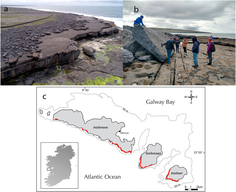
FIGURE 1. Examples of CBD in Western Ireland. (A) linear boulder ridge (12–15 m elevation above high water and 50–60 m inland) on Inishmore, Aran Islands: a number of boulders in this ridge were relocated during recent storms; and the 620 t megagravel block on the lower platform (5 m elevation and 30 m inland) was also moved; (B) Boulder ridge face (4.5 m elevation and 17 m inland) on mainland (County Clare), east of the Aran Islands: the tilted block (∼36 t) was moved 10 m inland in recent storms; (C) Aran Islands, showing general locations of CBD (red). The 30 m bathymetric contour is also shown. Modified after Cox et al. (2012).
Study Area: Aran Islands
Located off the west coast of Ireland, the Aran Islands lie across the mouth of Galway Bay (Figure 1C). Their Atlantic-facing coastlines have open ocean exposure with coastlines directly facing deep water, and their CBD are well documented (e.g., Williams and Hall, 2004; Scheffers et al., 2008; Cox et al., 2012; Cox et al., 2018). The islands are geologically homogeneous, with shallowly dipping Carboniferous limestone bedrock throughout (Williams and Hall, 2004). Coastal relief is variable, however, ranging from expansive low-lying shore platforms to sheer cliffs 90 m high. Although the islands form a NW-SE trending chain (Figure 1C), coastline shapes include long linear stretches as well as promontories and embayments. The island chain is arrayed at about 90° to the prevailing wind and wave direction (Williams and Hall, 2004), but local changes in coastal orientation mean that there is a substantial range of relative wave approach angles. On the Atlantic sides (where CBD mostly occur) the 30 m bathymetric contour ranges from about 50–900 m offshore (Figure 1C). Distributed along the ∼24 km of Atlantic-facing coastline are approximately 13 linear km of CBD (Cox et al., 2012). With their similar wave climates and geology, but varying coastline and nearshore conditions, the Aran Islands are an ideal location for studying the relationship between CBD occurrence, wave climate, and local geomorphology.
Methods
To address the interplay between offshore wave conditions, coastal geomorphology, and CBD occurrence, we integrate three datasets: presence or absence of CBD along the coast, coastal elevations, and wave climate. All data are tabulated in Supplemental Data.
CBD Occurrence
Existing field measurements of CBD, and associated survey data documenting elevations at those locations (Cox et al., 2012), form the basis for this analysis. The data were collected at intervals ranging from 50–100 m along sections of the coast where CBD are present. Most of these deposits were activated and partially rearranged in winter 2013–2014, including inland transportation of many large boulders against gravity (Cox et al., 2018; Cox, 2020). To carry out a more detailed examination (at 25 m intervals) and to include those portions of the coast where CBD are absent, we used Google Earth imagery (specifically from the Centre national d'études spatiales) to fill in data gaps and extend the survey along the entire length of the Atlantic-facing sides of the islands. This resulted in a dataset of 977 locations, with georeferencing, elevation, and CBD presence or absence recorded at each site (Supplementary Table S1).
Elevations
Elevation data were extracted from the Ordnance Survey Ireland digital elevation model (DEM), which included gridded elevations with 10 m horizontal resolution. For shore platforms with no CBD, elevation at the high-water mark was used as the reference datum. For CBD locations with existing data, we used high-tide referenced elevations that had been surveyed in the field by Cox et al. (2012).
Wave Data
Representative long-term wave conditions for all locations were obtained from the 34-years hindcast spectral wave model of Gallagher et al. (2014) and Clancy et al. (2016), using a Generalized Extreme Value distribution to estimate 100-years return periods. The 100-years maximum significant wave height (Hs,100), estimated at 1.5 km offshore of each location was used as a representative measure of extreme storm conditions (Supplementary Table S1). We chose the 1.5 km distance to capture deeper water conditions, less affected by nearshore wave transformation and breaking.
Dimensionless Elevation and CBD Occurrence
One of the puzzling aspects of CBD is why they occur in some places and not in other, apparently similar, locations (Figures 2A,B). Intuitively, there must be some interplay between waves and topography that renders some locations more prone or less prone to CBD development. We calculated dimensionless elevation as a way to investigate this relationship, using coastal elevation from high tide (Z) and 100 years modeled significant wave height (Hs,100) as
By combining wave energy and topography in a single dimensionless variable, the Z* approach integrates across two primary factors of fundamental importance in coastal geomorphology and sedimentology.
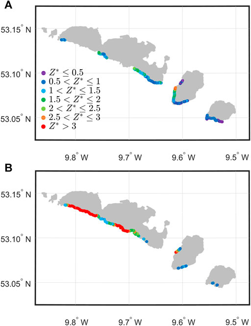
FIGURE 2. Aran Islands dimensionless elevations showing (A) almost all low Z* locations (cold colors) host CBD; whereas the locations without CBD (B) are predominantly at higher Z*.
The Z* quantity was introduced in Kennedy et al. (2021), where it was used to compare CBD at a wide range of sites worldwide (both storm and tsunami-related), in concert with other dimensionless quantities related to size and inland distance with the goal of determining bounding envelopes where CBD were found. The current study does not look at envelopes, but only the presence or absence of CBD along a long coastline as a function of Z*, asking whether the combination of topography and wave climate can predict whether CBD are likely to occur. As such, it represents an important test of the usefulness of this new approach. The lithologic homogeneity of the islands means that other important variables (e.g. rock density) are held constant. Boulder size varies significantly across sites (and varies with elevation: Cox et al., 2018); but that is not relevant to this analysis, which simply asks the binary question of whether CBD (in any shape or size) are likely to form.
Dimensionless elevations Z* in the Aran Islands dataset range from 0 to 7.22. Locations with Z*>1 have elevation greater than the 100-years significant wave height, whereas locations with Z*<1 are lower than the Hs,100 values. The data were binned by dimensionless elevation in intervals of 0.25, and for each Z* bin we show the proportion of locations with and without CBD (Figure 3). Figure 3 shows an almost monotonic relationship between Z* and the proportion of locations with CBD.
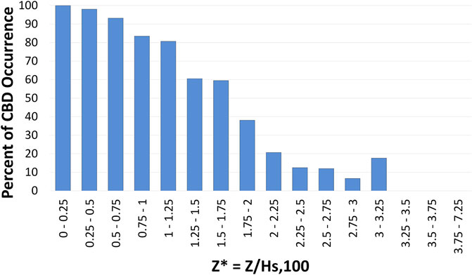
FIGURE 3. CBD presence (blue) as a function of dimensionless elevation Z*. The largest Z* at which CBD are present is 3.13, but only 18% of locations at that dimensionless elevation bin host boulders.
At locations with Z*< 0.25, CBD are present in 100% of cases. For locations with Z*< 1.25, a large majority of locations have CBD; for 1.25 < Z*< 2, CBD are present at 40–60% of locations; while there are many fewer occurrences of CBD for Z*>2. Once coastal elevation exceeds 3.25Hs,100, CBD are not observed at any locations.
Discussion
The clear relationship between Z* and CBD occurrence suggests that interplay between elevations and wave heights is a primary controlling factor; but the very gradual trend—and large elevation range where CBD can reasonably be present or absent—suggest that it is not the only important factor. The geographic distributions of Z* values as they correspond with CBD occurrence are shown in Figures 2A,B. Locations with CBD (Figure 2A) have low values for Z* (cold colors), whereas those without CBD tend to have higher Z* (warmer colors). The co-variation is notable, and consistent (Figure 3). A simple logistic regression between CBD presence/absence and Z* gives a p-value of
Inishmaan hosts the highest CBD on the Aran Islands, in terms of both elevation above sea level (up to 38 m) and dimensionless elevation (Z* up to 3.1, Figures 3, 4). This contrasts with Inishmore, where—although it has cliffs of the same height and higher than those on Inishmaan—there are no CBD above 26 m elevation, or at Z*>2.09. However, other aspects also set the Inishmaan high-elevation deposits apart, including sheer cliffs that extend to the water’s edge and their location along the deep sound between Inishmaan and Inishmore with strong tidal currents (Figure 4). Thus, although dimensionless elevation is clearly important (Figure 3) it is not the sole control on CBD occurrence at higher Z*.
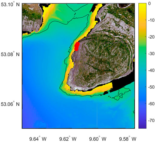
FIGURE 4. The western side of Inishmaan was the location of the only CBD present at Z*>2.5 on all the islands (red circles, N = 7). Bathymetry (m) and the 30 m depth contour are given as shown.
This simple study provides a substantial breakthrough in understanding the distributions of iconic Aran Islands CBD. Although a relationship between the scale of CBD and local elevation had been demonstrated for the Aran Islands (Cox et al., 2012, 2018), the pattern was noisy. The present dimensionless analysis approach provides both a more general and a clearer description of the relationship between wave forcing and CBD occurrence.
It remains to be seen whether the Z* cutoff values observed in this study are local, or whether they have more general dynamic significance. In their global compilation, Kennedy et al. (2021) found CBD at dimensionless elevations up to Z* = 3.8; but it was based on meta-analysis of published data, and therefore could not include nuances and specifics for individual places. Studies such as the present one, applying the Z* approach in a detailed way to specific CBD occurrences, will help grow our understanding of wave-coast interactions at high-energy rocky coastlines. The present study may be considered as an example of and a precursor to the kind of analyses that we hope others will carry out elsewhere.
It is important to note that, as a first-order examination of CBD dynamics, the analysis here neglects many important processes. Although clear relationships are seen here between boulder occurrence and dimensionless elevation, many other aspects remain not well understood. These include the generation of different deposit morphologies (isolated boulders, clusters, ridges), long-term accumulation and degradation of deposits, the influence of small-scale effects on CBD localization, and definitive establishment of the similarities and differences between tsunami and storm wave CBD signatures. Effects of local setting on CBD generation also remain poorly understood. The CBD research field is still young. Therefore, although this method provides new insights, detailed work on coastal boulder hydrodynamics, sedimentology, and geomorphology are required for full understanding of these complex systems. This might include investigations of nearshore wave transformation and local wave focusing, and detailed studies of the mechanisms of cliff overtopping and bore generation. Although recent work has shed some light on mechanisms of bore focusing and intensification (Bujan and Cox, 2020), our knowledge of local processes is largely limited to offshore forcing in the form of modeled wave heights. This is necessary but not sufficient to fully describe coastal boulder generation and transport.
Conclusion
Formation of coastal boulder deposits is complicated and poorly understood, and likely depends on factors that are still unknown. The dimensionless approach described here, however, integrating elevation and wave climate, unlocks a new level of understanding and permits comparison of locations with different conditions. It not only provides an explanation for the existence of CBD in some locations as opposed to others; it may also be used to analyze rocky coasts where CBD do not occur. This parameter should be tested at other sites to see if it yields similar results, as it may lead to a broader understanding of how waves and topography together play a role in the formation of CBD. In particular, this will allow direct comparison of CBD from widely varying areas, as part of ongoing efforts to determine whether there are simple unifying controls on these unusual deposits.
Data Availability Statement
The original contributions presented in the study are included in the article/Supplementary Material. Further inquiries can be directed to the corresponding author.
Author Contributions
All authors contributed to the writing, interpretation, and analysis. AK obtained the wave height and direction data. RC provided CBD data. AVB compiled and systematized the data, completed the digital topographic survey, and performed the initial analysis.
Funding
AVB and AK were funded by the University of Notre Dame. AK received funding from the National Institute of Standards and Technology, and from the National Science Foundation under award 1661015. RC acknowledges funding through the US-Ireland R&D Partnership Programme, and National Science Foundation award 1529756.
Conflict of Interest
The authors declare that the research was conducted in the absence of any commercial or financial relationships that could be construed as a potential conflict of interest.
Publisher’s Note
All claims expressed in this article are solely those of the authors and do not necessarily represent those of their affiliated organizations, or those of the publisher, the editors and the reviewers. Any product that may be evaluated in this article, or claim that may be made by its manufacturer, is not guaranteed or endorsed by the publisher.
Acknowledgments
The help of Frédéric Dias in providing access to climatological wave hindcasts is gratefully acknowledged.
Supplementary Material
The Supplementary Material for this article can be found online at: https://www.frontiersin.org/articles/10.3389/feart.2021.715383/full#supplementary-material
References
Bhatt, N., Murari, M. K., Ukey, V., Prizomwala, S. P., and Singhvi, A. K. (2016). Geological Evidences of Extreme Waves along the Gujarat Coast of Western India. Nat. Hazards 84, 1685–1704. doi:10.1007/s11069-016-2507-6
Bujan, N., and Cox, R. (2020). Maximal Heights of Nearshore Storm Waves and Resultant Onshore Flow Velocities. Front. Mar. Sci. 7. doi:10.3389/fmars.2020.00309
Clancy, C., O’Sullivan, J., Sweeney, C., Dias, F., and Parnell, A. C. (2016). Spatial Bayesian Hierarchical Modelling of Extreme Sea States. Ocean Model. 107, 1–13. doi:10.1016/j.ocemod.2016.09.015
Cox, R., Jahn, K. L., Watkins, O. G., and Cox, P. (2018). Extraordinary boulder Transport by Storm Waves (West of Ireland, winter 2013-2014), and Criteria for Analysing Coastal boulder Deposits. Earth Sci. Rev. 177, 623–636. doi:10.1016/j.earscirev.2017.12.014
Cox, R. (2020). Megagravel Deposits on the West Coast of Ireland Show the Impacts of Severe Storms. Weather 75, 72–77. doi:10.1002/wea.3677
Cox, R., Zentner, D. B., Kirchner, B. J., and Cook, M. S. (2012). Boulder Ridges on the Aran Islands (Ireland): Recent Movements Caused by Storm Waves, Not Tsunamis. J. Geol. 120, 249–272. doi:10.1086/664787
Etienne, S., and Paris, R. (2010). Boulder Accumulations Related to Storms on the South Coast of the Reykjanes Peninsula (Iceland). Geomorphology 114, 55–70. doi:10.1016/j.geomorph.2009.02.008
Gallagher, S., Tiron, R., and Dias, F. (2014). A Long-Term Nearshore Wave Hindcast for Ireland: Atlantic and Irish Sea Coasts (1979-2012). Ocean Dyn. 64, 1163–1180. doi:10.1007/s10236-014-0728-3
Goto, K., Miyagi, K., Kawana, T., Takahashi, J., and Imamura, F. (2011). Emplacement and Movement of Boulders by Known Storm Waves - Field Evidence from the Okinawa Islands, Japan. Mar. Geol. 283, 66–78. doi:10.1016/j.margeo.2010.09.007
Hansom, J. D., Barltrop, N. D. P., and Hall, A. M. (2008). Modelling the Processes of Cliff-Top Erosion and Deposition under Extreme Storm Waves. Mar. Geol. 253, 36–50. doi:10.1016/j.margeo.2008.02.015
Hoffmann, G., Grützner, C., Schneider, B., Preusser, F., and Reicherter, K. (2020). Large Holocene Tsunamis in the Northern Arabian Sea. Mar. Geol. 419, 106068. doi:10.1016/j.margeo.2019.106068
Kennedy, A. B., Cox, R., and Dias, F. (2021). Storm Waves May Be the Source of Some "Tsunami" Coastal Boulder Deposits. Geophys. Res. Lett. 48, e2020GL090775. doi:10.1029/2020GL090775
Kennedy, A. B., Mori, N., Yasuda, T., Shimozono, T., Tomiczek, T., Donahue, A., et al. (2017). Extreme Block and boulder Transport along a Cliffed Coastline (Calicoan Island, Philippines) during Super Typhoon Haiyan. Mar. Geol. 383, 65–77. doi:10.1016/j.margeo.2016.11.004
Lau, A. Y. A., and Autret, R. (2020). “Spatial Patterns of Subaerial Coarse Clasts,” in Geological Records of Tsunamis and Other Extreme Waves. Editors M. Engel, J. Pilarczyk, S. M. May, D. Brill, and E. Garrett (Amsterdam: Elsevier), 513–546. doi:10.1016/b978-0-12-815686-5.00024-9
Nott, J. (2003). Waves, Coastal boulder Deposits and the Importance of the Pre-transport Setting. Earth Planet. Sci. Lett. 210, 269–276. doi:10.1016/S0012-821X(03)00104-3
Paris, R., Naylor, L. A., and Stephenson, W. J. (2011). Boulders as a Signature of Storms on Rock Coasts. Mar. Geol. 283, 1–11. doi:10.1016/j.margeo.2011.03.016
Scheffers, A., Kelletat, D., Vött, A., May, S. M., and Scheffers, S. (2008). Late Holocene Tsunami Traces on the Western and Southern Coastlines of the Peloponnesus (Greece). Earth Planet. Sci. Lett. 269, 271–279. doi:10.1016/j.epsl.2008.02.021
Suanez, S., Fichaut, B., and Magne, R. (2009). Cliff-top Storm Deposits on Banneg Island, Brittany, France: Effects of Giant Waves in the Eastern Atlantic Ocean. Sediment. Geol. 220, 12–28. doi:10.1016/j.sedgeo.2009.06.004
Weiss, R., and Sheremet, A. (2017). Toward a New Paradigm for boulder Dislodgement during Storms. Geochem. Geophys. Geosyst. 18, 2717–2726. doi:10.1002/2017GC006926
Keywords: coastal boulder deposits, Aran Islands, coastal geomorphology, wave dynamics, nearshore processes, coastal erosion, storms
Citation: Van Blunk A, Kennedy AB and Cox R (2021) Interplay Between Coastal Elevation and Wave Height Controls the Occurrence of Coastal Boulder Deposits in the Aran Islands, Ireland. Front. Earth Sci. 9:715383. doi: 10.3389/feart.2021.715383
Received: 26 May 2021; Accepted: 09 September 2021;
Published: 24 September 2021.
Edited by:
Annie Lau, The University of Queensland, AustraliaReviewed by:
Gösta Hoffmann, University of Bonn, GermanySiddharth Prizomwala, Institute of Seismological Research, India
Copyright © 2021 Van Blunk, Kennedy and Cox. This is an open-access article distributed under the terms of the Creative Commons Attribution License (CC BY). The use, distribution or reproduction in other forums is permitted, provided the original author(s) and the copyright owner(s) are credited and that the original publication in this journal is cited, in accordance with accepted academic practice. No use, distribution or reproduction is permitted which does not comply with these terms.
*Correspondence: Andrew B. Kennedy, andrew.kennedy@nd.edu