Spatial characteristics and cultural factors of Yi nationality traditional dwellings based on spatial syntax
 Qin Lai
 Wei Liu1*
 - 1College of Architecture, Southwest Minzu University, Chengdu, China
- 2College of Water Resource and Hydropower, Sichuan University, Chengdu, China
The spatial layout of traditional residential houses is closely related to national and regional characteristics and culture. The traditional village of Yi nationality is selected, and the organization structure of the outside village and the inside living space is studied through the graphical and quantitative analysis method of space syntax. The primary purpose of this study is to analyze the spatial characteristics of Yi dwellings and infer the cultural factors behind them. To explore how to integrate traditional spatial characteristics into contemporary design and promote the preservation and inheritance of architectural culture. The results show that 1) the outer village space of residential houses is characterized by weak identifiability, compact and loose organizational structure, weak permeability, and weak accessibility; 2) The interior space of dwellings presents a spatial layout with the main room and courtyard as the core as a whole. The interior space of dwellings is abundant and flexible, and the accessibility of ancillary functional space is weak. 3) The cultural causes of the formation of these spatial features include complex landforms, family systems, hierarchical systems, semi-agricultural and semi-pastoral production modes, the concept of valuing family harmony, the use of regional materials, respect for nature, fire worship, etc. 4) The spatial characteristics of traditional dwellings are inherited in contemporary dwellings. Fuzzy elements can be added in villages according to family relations, and characteristic Spaces such as courtyards and fire ponds in traditional dwellings can be preserved.
1 Introduction
Liangshan Yi area is one of the famous national areas in China. Traditional villages and dwellings’ internal spatial fabric features reflect a certain period and region’s cultural logic production and lifestyle. However, due to the impact of modernization and urbanization, these traditional villages and dwellings face the danger of severe destruction and loss. Therefore, to protect and inherit these cultural heritages, it is necessary to conduct in-depth research on their spatial characteristics and the cultural factors behind them. In studying Liangshan Yi traditional villages and dwellings, scholars mainly study their architectural forms, structural elements, decorative arts, and other aspects (Yang and Qin, 2019; Su, 2020). For example, Du (2009) summarized the shape and color of Yi dwellings, including the features of external walls, roofs, doors and Windows, and decorations. Cheng (2017) summarized the construction system and cultural and technical characteristics of Yi architecture and explored the formation mechanism, development, and evolution law of settlements. Chen (2020) also discussed the influence of roof construction materials with different thermal properties on the indoor thermal environment of farmhouses and put forward the optimization principle of roof construction materials of farmhouses. These studies have shown the value of studying Yi traditional villages and dwellings, and this architectural culture deserves to be reviewed and continued. However, the study of Yi architectural culture mainly focuses on qualitative construction forms, needing more quantitative research on its spatial culture.
In terms of spatial characteristics and cultural factors, the research fields include cultural function elements (Shi et al., 2021), landscape (Hou et al., 2020), gas emission (Liu and Li, 2021), architecture (Xu and Chen, 2021; Kamelnia et al., 2022), etc. Researchers adopted different methods to conduct quantitative research on them. For example, some scholars used the nearest distance analysis, nuclear density analysis, buffer zone analysis, and imbalance index analysis, some scholars analyzed the spatial distribution reasons of historical and culturally famous towns and villages by combining historical, geographical factors, and relevant factors of conservation status. However, the evolution process of architectural heritage, surrounding land use, roads, water systems, vegetation, and fields has yet to be analyzed (Wang et al., 2022). Some scholars studied the spatial characteristics of rural cultural landscapes using kernel density analysis, Tyson polygon analysis, and interpolation in ArcGIS spatial analysis. However, they need to pay more attention to rural regions and cultures (Yang et al., 2022). Some scholars studied the spatial distribution characteristics of traditional villages on the Qinghai-Tibet Plateau using the nearest neighbor index, kernel density estimation, and spatial autocorrelation analysis. They also conducted regression analysis on the factors affecting their spatial distribution. However, this study focuses on the macro distribution of villages and needs to discuss traditional villages’ form, structure, landscape, and architecture (Jin et al., 2020). In general, there have been many studies on the spatial characteristics of buildings. However, the research perspective tends to be macroscopic, and there needs to be more subtle studies on the external environment, internal living space, and culture of residential buildings.
In the field of research on the combination of space syntax and architectural space, space syntax is considered a more scientific language for thinking and talking about space (Liu et al., 2021), and the research results are relatively mature. For example, Zhu et al. (2023) used space syntax to analyze the tourism space of the Gulangyu historic site, providing a visual and quantitative method for tourism management. Through the analysis of space syntax, Rao et al. (2022) investigated the spatial layout characteristics of Huzhai under the influence of the patriarchal system and the corresponding spatial usage relationship between different users. Huang et al. (2019) used space syntax theory to analyze the spatial topological layout of traditional quadrangle courtyards, thus inferring the cultural connotation of traditional quadrangle courtyards. Based on the research idea of space syntax theory, Wang et al. (2022) divided the plane and elevation of kitchen rooms in elderly families. Thus, space syntax applies to the study of mesoscale villages and small-scale dwellings (Mustafa and Rafeeq, 2019; Chu and Wu, 2022), which can provide more scientific ideas for the refined design of towns and buildings from the perspective of space. Therefore, based on space syntax, this paper makes a subtle analysis of the space of traditional Yi villages and dwellings in Liangshan, summarizes their spatial characteristics, and analyzes the discernability, aggregation, and dispersion degree, penetration ability, and accessibility of the village space by calculating the Synergy degree, integration degree, connection value, and depth value of the village space. Through the calculation of topological relation, integration degree, connection value, depth value, and visual field of the internal space of dwellings, the position relation and spatial structure, aggregation focus, penetration ability strong point, accessibility strong point, and essential node space of different internal space of dwellings are analyzed. At the same time, qualitative analysis of the cultural connotation behind it, including cultural logic and production, lifestyle, and other aspects. The purpose is to protect the characteristics of Liangshan Yi dwellings and provide a reference for the contemporary application of their spatial characteristics.
2 Materials
The Yi people are located in the southwest of China, and the local villages and dwellings are very ethnic and regional. Among them, Siganpu Village, Gutuo Village, and Sijiji Village are located in the hinterland of Liangshan (Figure 1), with little external intervention and high village morphological integrity, and their dwellings have been included in the list of Chinese traditional protection. Therefore, the selection of these three villages as research samples is typical and representative. The average elevation of these three villages is 2,200 m, 2,400 m, and 3,000 m respectively. The spatial organization structure is relatively dispersed and the building density is small. The traditional residential buildings in the village are wooden tiled houses, and some residential buildings have enclosed courtyards, showing a courtyard pattern of one main room and two side rooms. Some dwellings have no courtyards and are independent dwellings. The construction materials of dwellings are rammed earth, wood, and flagstone. The external walls usually adopt the masonry practice of rammed earth or the combination of rammed earth and wood. The interior walls, roofs, and pillars are made of wood, and the roofs are also made of flagstone and rammed earth, and the roofs are mostly double-slope roofs and single-slope roofs. The structure of the residential building is a mortise and tenon joint fan frame structure, which has five three-hop, seven five-hop, nine five-hop, eleven nine-hop, and other different forms. The house has only one floor, but the interior is divided into mezzanine spaces with wooden panels. Nowadays, these traditional villages mostly show the phenomenon of hollow villages, and traditional houses are mostly abandoned and uninhabited. Residents moved to lower elevations with more convenient transportation, traditional construction techniques and characteristics were gradually forgotten with the adoption of modern materials, and the spatial characteristics of traditional villages and dwellings were also abandoned.
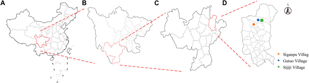
FIGURE 1. Location of the samples: (A) China; (B) Sichuan Province; (C) Liangshan Yi Autonomous Prefecture; (D) Meigu county.
3 Methods
3.1 Space syntax theory
Professor Bill Hillier and Julienne, (1984) at Cambridge University founded the theory of space syntax to explain the spatial forms of buildings, communities, towns, and other different scales and their social and economic activities from the perspective of spatial construction activities. The theory holds that space is the medium connecting form and socio-economic function rather than just the static background of people’s activities. Through the construction of spatial patterns to achieve their own social, economic, and cultural goals, at the same time, the construction of space itself is a part of social, economic, and cultural activities. People can perceive and recognize this spatial structure by walking through the space. Therefore, from the perspectives of system theory, integration theory, and development theory, the technology of space syntax attempts to intuitively and quantitatively reveal the inexpressible social logic and spatial rules under spatial phenomena by analyzing the complex relations between different spaces at different scales and their interaction with people’s activity patterns and puts forward the self-organizing spatial structure and its evolution model. Space syntax is widely used in daily life and academic research, For example, in map making, space syntax describes geospatial relationships, such as the distance, direction, and corresponding position between places. In spatial cognition and psychological research, space syntax is also used to study human perception and cognitive space, to explore how humans understand and remember spatial information, and the impact of spatial data on human behavior and decision-making. Space syntax has quantitative and qualitative advantages in studying spatial form and its socio-cultural logic. Therefore, as a minority nationality in China, the Yi people have a unique traditional architectural culture. Space syntax can accurately describe and analyze the spatial structure of traditional Yi villages and dwellings, including the village form and the position relationship between rooms. Secondly, Yi traditional houses’ spatial structure and layout reflect residents’ needs and have rich cultural connotations and symbolic significance. By analyzing space syntax, we can better understand the artistic purpose and symbolic importance of Yi traditional dwellings to protect, inherit, and develop this cultural heritage effectively.
3.2 Research methods and procedures
The author conducted a field survey of the traditional villages in Liangshan Yi Autonomous Prefecture and established a mathematical model. This paper explores the spatial characteristics of traditional Yi villages and dwellings using the axis analysis method, convex space method, and visibility analysis method in space syntax. It makes a qualitative analysis of the cultural causes behind them. On this basis, how to apply its spatial characteristics and cultural reasons to modern architecture is discussed, and the research technology route is shown in Figure 2. The axis analysis method in space syntax is used to study the large-scale space of the village as a whole, the convex space method is used to study the interior space of residential buildings, and the visibility analysis method is used to study the visual degree and line of sight guidance of the indoor critical node space in a small range.
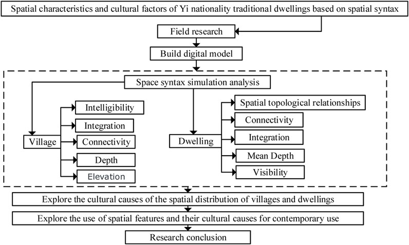
FIGURE 2. Research framework.
In the study of village space, the axis model of space syntax is used to analyze village space and village roads. In order to describe the spatial structure of the village, the axis represents the backbone of the village street network, and then the village spatial axis model is generated. Based on the graph theory and topology principle, the spatial topological relationship is described using various parameters, and the street space of a traditional village is translated by straight lines to reflect the behavior and trends of people. The village axis model drawn by CAD was imported into Depthmap software for calculation, and the parameter variables such as the degree of synergy, integration, connection, and depth of the village were calculated. The village’s spatial structure and shape characteristics were reflected by quantitative research, and the cultural causes were analyzed. The integration degree is divided into global integration degree and local integration degree, among which the local integration degree uses a three-step depth, that is, after space remapping, with the number of three topological steps as the limit, such a small range near the central area is intercepted to calculate the integration degree of this new topology structure.
The convex space model in space syntax is used to analyze the plane space of residential buildings. The residential building model drawn with CAD was imported into Depthmap software, and Depthmap software was used to divide the residential area into different spatial units. At the same time, the residential plane was divided into a more detailed 100*100 network. Then, the topological relationship, integration degree, connection value, and depth value among spatial units are calculated. The location relationship and spatial structure, aggregation focus, penetration ability, accessibility, and essential node space of different internal spaces are analyzed, and their cultural factors are qualitatively analyzed. In researching crucial node space, this paper uses the perspective analysis method in space syntax to explore the perspective hierarchy and its cultural causes.
4 Research results
4.1 Villages
The following uses the axis analysis method to calculate the synergy degree, integration degree, connection value, depth value, and other parameter values of Siganpu Village, Gutuo Village, and Shijiji Village. The axis synergy degree means to judge the importance of an axis in the whole system according to the number of axes directly connected with it. This reflects the correlation between the global integration degree and the local integration degree of the axis. The higher degree of correlation indicates a higher degree of synergy, suggesting that the whole spatial structure can be deduced from the local spatial design, and the order and logic of space can be evaluated with the degree of synergy. Axis integration is the degree of aggregation and dispersion of each spatial node in a network system. The integration degree is divided into the global and local integration degrees. The global integration degree is the aggregation and dispersion degree of a space and a system, and the local integration degree is the aggregation and dispersion degree of a room and adjacent area. Axis connection value refers to the number of other axes directly intersecting with a particular axis, indicating the closeness of the connection of each node in the space. The higher the spatial connection value, it suggests that it is closely connected with the inner space of the system and has robust connectivity and permeability to the inner area of the system. The possibility of internal infiltration can be judged. The axis depth value is calculated as the number of topological steps from the starting axis to all destination axes, which expresses the convenience of the space and is a measure of accessibility. The principle of selecting synergy degree, integration degree, connection value, and depth value is to analyze the identifiability, aggregation, dispersion degree, connectivity and penetration ability, and accessibility of village space (Qiang, 2022). In addition, axis analysis in space syntax uses an axis diagram to represent the spatial layout, and the axis diagram of all lines is the set of all tangents drawn according to the vertices of all objects that can look at each other. Where the parameter values form a hierarchical chromatography, red (warm color) represents a higher corresponding value, and blue (cool color) means a lower corresponding value.
4.1.1 Synergy degree
The degree of synergy (R2) is the correlation between the degree of global integration and the degree of local integration, that is, the degree of difficulty for people to perceive and understand the overall spatial system from a local perspective, and it can reflect the recognizability of space from the level of network structure. At the same time, understanding the global basis is derived from the observer’s association and construction of the local perception, so this parameter maps the degree of the local correlation to the global. According to space syntax theory, when 0<R2≤0.5, the correlation between local and global integration degree is weak. When 0.5<R2≤0.7, the correlation between local and global integration degrees is general. 0.7<R2 indicates a strong correlation between local and global integration (Hong and Qian, 2021). The spatial axis with a high degree of synergy often forms local public space with high social vitality and diversified functions, which makes it easy to create a clear and recognizable psychological picture. As seen from the synergy degree analysis chart (Figure 3), Siganpu Village, Gutuo Village, and Sijiji Village values are 0.2353, 0.0198, and 0.0987, respectively. The synergy degree of the layout structure of the three villages is at a low level. The synergy degree of Siganpu Village is significantly greater than that of Gutuo Village and Sijiji Village, and the spatial recognition from the locals to the whole is weak. However, the vertical and horizontal axes of the scatter plot have a specific correlation, and the fitting degree of the trend line has a certain predictability, which indicates that the traditional village space has both local and overall correlation and fuzziness.
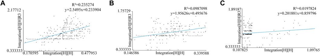
FIGURE 3. Synergy degree: (A) Siganpu Village; (B) Gutuo Village; (C) Shijiji Village.
There are two main reasons for the formation of this spatial feature. On the one hand, because the traditional Yi culture pays attention to the harmonious coexistence between man and nature, the construction of conventional Yi houses often follows the characteristics of natural terrain and landforms, such as buildings along mountains or by the water, which brings certain ambiguity to the identification of village space. On the other hand, the Liangshan Yi people have a family branch system (Mo and Xiao, 2022), a family branch naturally formed by the paternal bloodline. The residents of traditional villages are usually composed of several family branches, each of which has its leader and rules, and there is a specific connection and interaction between the family branches, which brings a particular order to the village.
4.1.2 Integration degree
Integration degree can describe the distribution of village space divided into global and local integration degrees. The integration degree reflects the relationship between one point and other points in the area. The higher the international integration degree, the higher the integration degree and the closer the spatial organization structure of the village. On the contrary, the closer the global integration degree value is to 0, the lower the integration degree is, and the more dispersed the spatial organization structure of the village is. The degree of local integration represents the ease of reaching a particular space within a limited depth radius, and a room with a high degree of regional integration can exert influence on a small scale.
According to the calculation of Depthmap software, the average global integration degree of Siganpu Village, Gutuo Village, and Shijiji Village is 0.350389, 0.241029, and 0.246088, respectively, ranging from 0.107825 to 1.09765. The mean local integration was 1.12722, 1.12722, and 0.905173, respectively, ranging from 0.333333 to 2.17712 (Table 1). This indicates that the global average integration degree of the three villages is low, meaning that the integration degree of the villages is low, and the spatial organization structure is scattered. As can be seen from the global integration degree analysis diagram (Figure 4), the brightest part of the axis of the three villages is almost in the middle of the town, indicating that the area with the highest global integration degree is in the middle of the city, and the spatial organization structure is relatively close. At the same time, comparing the three villages shows that the color of the overall integration degree axis of Gutuo Village is cold, indicating its spatial organization structure is relatively dispersed. This is because the dwellings in Guto Village are built on straight slopes, while those in Siganpu Village and Shijiji Village are built on U-shaped slopes. The layout of the houses is that a main road gathers on both sides of the hill (Figure 7). When the dwellings are built on terrain with straight slopes, the spatial organization structure of the villages is relatively scattered. The residential buildings are built on both sides of the hill, and the spatial organization structure is pretty close. The dwellings were built on sloping terrain, which is related to the traditional mode of production, which is half farming and half herding. Therefore, the site selection of Yi dwellings follows the principle of “grazing at the top, livable at the middle, and farming at the lower,” they are usually built on sloping terrain, reflecting their semi-nomadic culture. As seen from the local integration degree analysis chart (Figure 5), the place with a higher local integration degree has more road axes. In this small range, space has a significant influence. In general, the regional integration degree of the three traditional villages is not different, and the influence level is similar. The local integration degree of the town is at the medium level, which indicates that its space is generally clustered with the adjacent room, and the organizational structure with the adjoining area is tight and open. This is because there is a large amount of land in the village for residents to build, and people can choose plots at will to make, but because of the family system, the family system dominated by the paternal line will build houses together (Mo and Xiao, 2022).
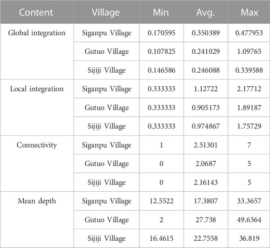
TABLE 1. Axis model parameters.
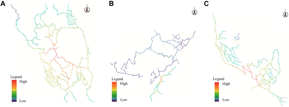
FIGURE 4. Global integration: (A) Siganpu Village; (B) Gutuo Village; (C) Shijiji Village.
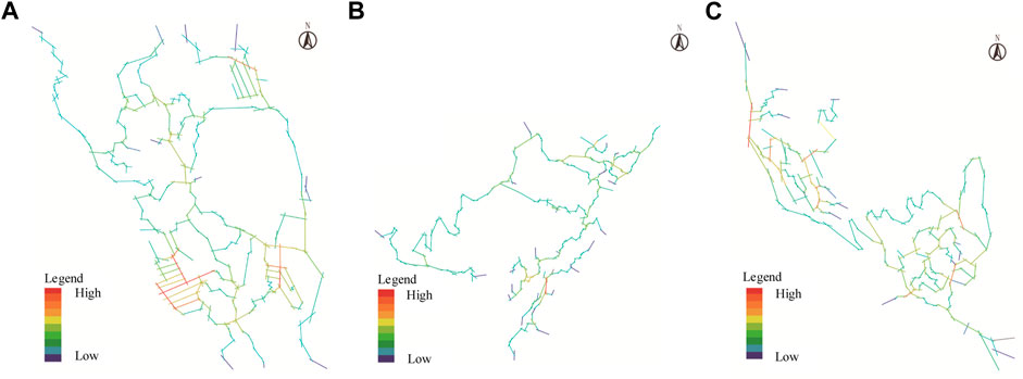
FIGURE 5. Local integration: (A) Siganpu Village; (B) Gutuo Village; (C) Shijiji Village.
4.1.3 Connectivity
Axis connectivity is the number of other axes directly intersecting with an axis and is the sum of the number of spaces connected to the ith node space. The connection value represents the penetration degree of the system space. According to the calculation of Depthmap software, the average connection values of Siganpu Village, Gutuo Village, and Shijiji Village are 2.51301, 2.0687, and 2.16143, respectively, ranging from 0 to 7 (Table 1), which indicates that some village Spaces do not have penetration capacity. As seen from the connectivity analysis chart (Figure 6), the connectivity values among the three villages are not high, their mutual permeability is almost average, and they also have similar spatial independence. This is often due to the topography of the Liangshan area, land use restrictions, the village being located in the mountains, the terrain being complicated, and the road needs to be more impassable, resulting in the lack of close contact between the dwellings. However, the connection value axis of Gutuo Village is brighter than that of Siganpu Village and Sijiji Village. The overall connectivity is more vital, which is evenly correlated with the slope and slope direction of the residential construction site of Gutuo Village (Figure 7). The connection value of Siganpu Village is higher in the southwest part of the village, which is the newly built residential building planned in the later period, with higher building density and higher spatial penetration. The distribution of connection values in Gutuo Village is similar to the degree of local integration, and the permeability of space is identical to the degree of regional integration, which is also affected by complex terrain.

FIGURE 6. Connection values: (A) Siganpu Village; (B) Gutuo Village; (C) Shijiji Village.
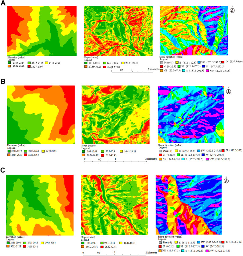
FIGURE 7. Elevation map: (A) Siganpu Village; (B) Gutuo Village; (C) Shijiji Village.
4.1.4 Depth value
Depth refers to the amount of space that needs to be traversed from one area to another. The greater the depth value, the weaker the reachability of the room and the more complex the space. On the contrary, the more reachable the area is. According to the calculation of Depthmap software, the average depth values of Siganpu Village, Gutuo Village, and Sijiji Village are 17.3807, 27.738, and 22.7558, respectively, ranging from 2 to 49.6364 (Table 1), which indicates that the overall spatial structure of the three villages is relatively complex and the accessibility is weak. In addition, the depth value of Gutuo Village is brighter than that of Siganpu Village and Sijiji Village, and the spatial accessibility is weaker. As can be seen from the elevation analysis chart (Figure 7), the overall elevation difference between the highest point and the lowest point of residential construction in Gutuo Village is higher than that in Siganpu Village and Sijiji Village, so the spatial accessibility is weaker. In addition, depth value analysis helps to determine the most easily oriented and least oriented areas in the villages. From the depth value analysis chart (Figure 8), it can be seen that the depth values of Siganpu Village, Gutuo Village, and Sijiji Village are the largest in the northwest, southwest, and northwest directions, and these are the areas of the villages that are the least oriented. The accessibility of the dwellings here is weak. The central part of the village has the lowest depth value and is the most accessible area for orientation. There are many ways to reach the residential houses, and accessibility is vital. The accessibility of the remaining regions is centered in the middle, and the echelon decreases to the periphery. This is related to the foreign war and the war of “fighting enemies” between the Yi family branch and the family branch based on the family system in Liangshan. All the sites of Yi villages are in the mountains, with more or less dangerous geomorphological features, rugged and perilous access roads, lateral raves, and external partitions. Objectively, the village site selection has played a military defense role.
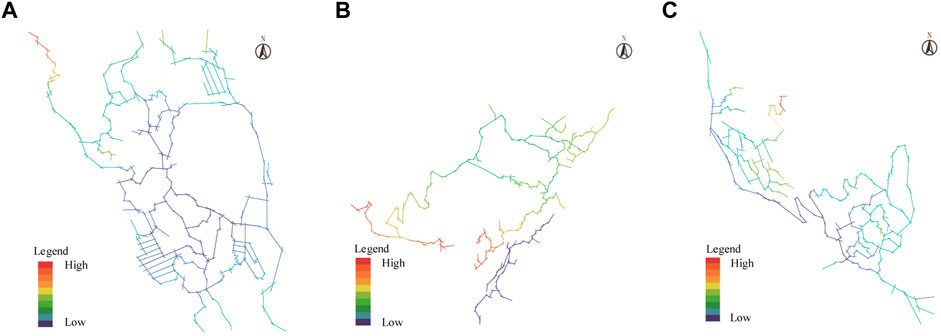
FIGURE 8. Depth value: (A) Siganpu Village; (B) Gutuo Village; (C) Shijiji Village.
4.2 Dwelling
Typical dwellings in Siganpu Village, Gutuo Village, and Sijiji Village were selected as research objects. Based on the topological model and convex space model in space syntax, Depthmap software was used to analyze the three quantitative indicators of integration degree, connectivity degree, and depth. The topological relation in space syntax can be used to obtain the location relationship and spatial structure between different elements in the space. The critical gathering space of residential buildings can be judged by the spatial integration degree, the strong penetration ability of the internal space of residential buildings can be judged by the connection degree, the depth value can judge the strong accessibility point of the interior space of residential buildings, and the visual field can analyze the critical area of residential buildings. At the same time, qualitative analysis of the cultural factors behind this.
The typical residential houses in Siganpu Village and Siji Village comprise three main parts: main building, auxiliary building, and courtyard. From the perspective of spatial enclosing degree, the plane form is the “U" font layout, an introverted and convergent spatial structure. The primary function (bedroom, dining room, kitchen, storage room, etc.), the internal space is divided by wooden boards, and the layout is more flexible (Figure 9). The dining room and kitchen on the first floor have no specific area; the dining room consists of temporary wooden tables in the middle of the main room, and cooking occurs in the fire pond position. The mezzanine on the second floor stores food, which is reached by a movable wooden ladder (Figure 10). The attached functional space includes a utility room, poultry breeding room, etc., and the layout is relatively regular. The typical residence in Gutuo Village is a single building with bedrooms, storage rooms, kitchens, restaurants, and other functions. Compared with the dwellings in Shijiji Village and Gutuo Village, it has a “one” font layout, and there is no independent courtyard and side room space for breeding and storing sundry materials.
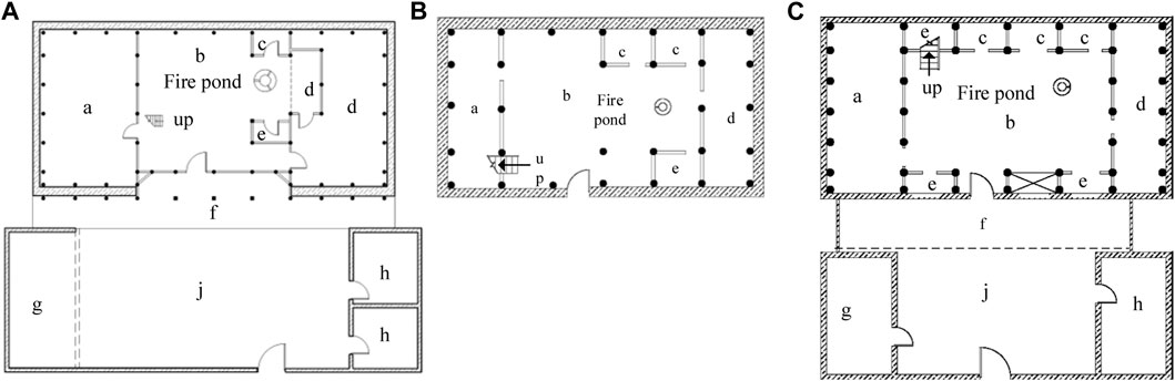
FIGURE 9. First-floor plan: (A) Siganpu Village; (B) Gutuo Village; (C) Shijiji Village.
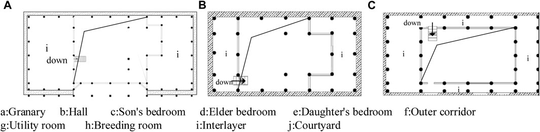
FIGURE 10. Interlayer floor plan: (A) Siganpu Village; (B) Gutuo Village; (C) Shijiji Village.
4.2.1 Spatial topological relationship
Topological relation in space syntax can obtain the position relation and spatial structure of different elements in space. By analyzing the spatial topological relationship of typical dwellings in the three villages (Figure 11), it can be found that the bedrooms are arranged nearby, and the positional relationship between bedrooms and storage rooms is parallel. This is because the Yi people have a tradition of attaching importance to family harmony and unity. The bedrooms of the children are located on both sides of the bedrooms of the elders, the bedrooms of the elders are located closest to the fire pond, and the bedrooms of the younger generation are arranged next to the bedrooms of the elders, implying mutual dependence and support between family members. In addition, as can be seen from the layout of each bedroom, the spatial structure is flexible because of the use of lightweight regional materials such as wood and bamboo. In addition, it can be seen from the three residential houses that the construction scale and the number of rooms are quite different. The residential houses in Sijiji Village have a more extensive construction scale and more rooms, which indicates that the family is more prosperous, and this wealth gap is related to the hierarchical culture of the Yi people (Wen, 2013). The hierarchy was formed during the period of slave society, and the Yi people were divided into black Yi and White Yi, with the black Yi as the ruler enjoying power and the White Yi as the ruler. They had an independent economic life but had a small amount of means of production and livelihood.

FIGURE 11. Calculation results of spatial topological relationships: (A) Siganpu Village; (B) Gutuo Village; (C) Shijiji Village.
It can be seen from the topological structure diagram of the dwellings in the three villages that the spatial structure of the houses in Siganpu Village and Sijiji Village with independent courtyards is the primary and secondary core type (Figure 12) and that of the dwellings in Gutuo village without separate enclosure is the primary core type. The central core space is the hall, and the secondary core space is the courtyard. The two core Spaces are connected with other auxiliary Spaces (bedroom, storage room, breeding room), and each functional area is smoothly connected. From the perspective of use function, two branch centers appear in a topology, mainly influenced by the semi-agricultural and semi-pastoral production mode, and form two branches by dividing the functional space of different service objects. The main service objects of the operating room with the main hall as the core are people and crops, and the main service objects of the functional space with the courtyard as the core are crops and poultry.
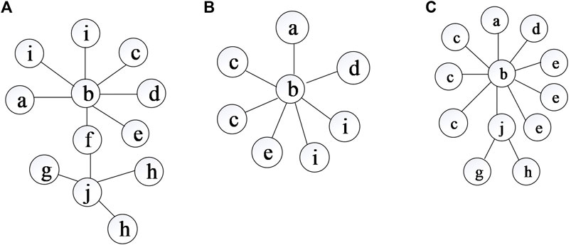
FIGURE 12. Abstract diagram of the spatial topological relationship: (A) Siganpu Village; (B) Gutuo Village; (C) Shijiji Village.
4.2.2 Degree of integration, connection value, and depth value
The convex space model in Depthmap software is used to analyze the plane space of residential buildings. As shown in Table 2, regarding the integration degree of residential buildings, the typical halls, outer corridors, and courtyards of the three villages have a higher integration degree, a more compact spatial layout, and a greater possibility of crowd gathering and communication. The critical gathering areas inside the dwellings are the hall, the outer corridor, and the courtyard. This is because the hall is the core of the dwelling and the place where members of the family and nationality groups gather, communicate, worship, and celebrate. The outer corridor is the transitional space connecting the hall and the courtyard. The courtyard is the secondary public space of the traditional dwelling, adjacent to the utility room, poultry breeding room, and the outer corridor. Function of free-range poultry. These reflect the social culture, religious culture, and farming culture of the Yi. At the same time, the hall, the outer corridor, and the courtyard form a whole, forming a continuous space order. The connection between these key areas is natural and smooth, which makes the boundary between the inner and outer space of the dwellings blurred, forming a natural living environment, which also reflects the Yi people’s culture of advocating nature.
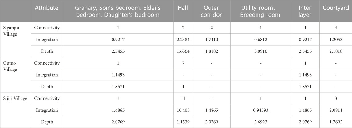
TABLE 2. Summary of the properties of spatial layout based on convex space analysis.
Regarding the connection value of the dwellings, the connection value of the hall of the dwellings in Siganpu Village, Gutuo Village, and Shijiji Village is 7, 7, and 11, respectively. The connection value of the courtyard of the dwellings in Siganpu village and Shijiji village is 4 and 3, respectively. The connection degree is high, the space permeability is good, and it has specific publicity. The hall occupies the central position of the whole dwelling, which is the core of the Yi traditional dwelling and the main public space of the conventional dwelling. In addition, due to the limitation of the regional material rammed earth, the thickness of the rammed earth wall is generally more than 0.5 m to bear weight. Multiple rooms are built around the hall and courtyard to construct a safe floor for the dwelling.
Regarding the depth value of the dwellings, the hall room of the three villages has the lowest depth value, which is the strong point of accessibility. The side room (utility room, breeding room) in the layout of one main room and two side rooms has the highest depth value and the weakest accessibility. This is also influenced by the “semi-agricultural and semi-pastoral” mode of production and religious beliefs. On the one hand, utility rooms and breeding rooms are usually used to store unclean articles and living things to avoid the smell and influence of contaminated articles and living things in the main house. On the other hand, the main house is regarded as a sacred space, accessible only to the spirits of family members and ancestors. Therefore, the utility and breeding rooms are relatively independent from the main house, and there is no direct doorway to the main house.
4.2.3 Visibility
In addition, from the spatial integration diagram of the main building (Figure 13), it is found that the high-perceptive space presents a continuous state from outdoor to indoor and extends to the location of the fire pond, which becomes the focus of visual perception. The color in the figure indicates the perceptibility of the building space. The warmer the color, the higher the perceptibility; the colder the color, the lower the perceptibility. Fire pond has a vital position and value in traditional Yi culture and is an essential spatial node. Through the view level analysis of the fire pond space, it is found (Figure 14) that it has a good sight line. As the core space of traditional Yi dwellings, the fire pond space is the focal point of the indoor view, which can observe each room’s situation, including the children’s bed and the master and the storage room of grain. In addition, the fire pond is the center of the family, and around the fire pond is the activity area of the family. The space layout of the residential houses is centered on the fire pond, surrounded by functional areas such as kitchen, living room, and bedroom. This layout can facilitate the communication and interaction between family members, become a place for family members to gather, communicate, and sacrifice, and enhance the family’s cohesion. This is not only because the Yi people attach importance to the harmony and unity of the family but also because the Yi people have the fire pond culture (He, 2022), which is regarded as a sacred symbol representing the unity and happiness of the family. The Yi people believe that the fire in the fire pond can drive away disease and bad omen and protect the health and safety of family members. During some critical festivals and rituals, the Yi people will light bonfires in the fire pool to offer sacrifices to their ancestors and gods and pray for good harvest and peace.
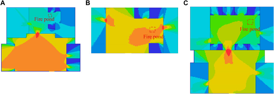
FIGURE 13. Analysis of dwelling spatial integration: (A) Siganpu Village; (B) Gutuo Village; (C) Shijiji Village.
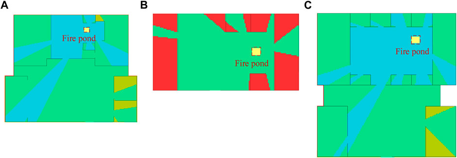
FIGURE 14. Spatial viewshed level of the fire pond: (A) Siganpu Village; (B) Gutuo Village; (C) Shijiji Village.
5 Discussion
This paper discusses the spatial characteristics of Yi traditional dwellings from the perspective of space syntax, but the study has some limitations. First, there are only three typical villages and homes in the current analysis, and more villages and dwellings can be expanded. Secondly, because the town is located between high mountains, a small number of homes are situated independently outside the residential gathering area, which needs to be considered. In the future, a more extensive scope can be expanded for research. The spatial characteristics of Yi traditional dwellings are closely related to their unique cultural factors, and the inheritance of architectural traits needs to be based on cultural heritage. Therefore, in constructing dwellings in the contemporary Yi area, the spatial characteristics of traditional dwellings should be combined with cultural causes. Thus, the following suggestions are put forward for the modern application of the spatial attributes of traditional villages and dwellings:
1) In the planning and design of villages, while the road planning is orderly, some fuzzy elements can also be added according to the boundaries of family relations; the gathering area of village space can be set in the middle of the terrain with height difference according to the elevation of the landscape. The connectivity and permeability of space can be increased by making residential buildings in the same slope direction. It can reduce the topographic height difference between dwellings and increase space accessibility.
2) In the design of a single building, the internal space is divided into several small rooms to strengthen the close connection between family members. It can continue the divergent space layout form with a courtyard and hall as the core and separate the production and living space with a courtyard and hall as the core. The critical gathering areas of traditional dwellings (galleries, outer corridors, courtyards) are preserved, and the inner and outer Spaces form a smooth and continuous spatial sequence to enhance the natural attributes of dwellings. Keep fire ponds, courtyards, and other characteristic Spaces.
3) In the construction of Yi dwellings, social culture, religious culture, production and lifestyle, family system, regional characteristics, etc., should be considered, and these cultural factors should be reflected in the interior space of villages and buildings.
6 Conclusion
According to the above space syntax, the quantitative indicators of the traditional Yi villages and residential Spaces in Liangshan are calculated and analyzed, and the following conclusions are drawn:
The village space has the following characteristics and cultural causes: the spatial identification is weak, and the local and overall correlation is also fuzzy, which is related to the complex landform and the family system of the Yi people. The spatial organization structure is compact and loose, which is associated with the semi-nomadic culture of the Yi people and the slope direction of the village construction site. The tightness of the local spatial organization structure is generally related to the regional culture and family system with low architectural density. The spatial permeability is weak, which is associated with the difference in slope and complexity of terrain in the Yi area. The spatial accessibility is inadequate due to the village construction’s poor height and the Yi people’s military defense culture.
The interior space of dwellings has the following characteristics and cultural causes: the rooms of the younger generation are arranged around the rooms of the elders, and the rooms of the elders are placed around the fire pool, which is related to the concept of family harmony and unity. The internal space of dwellings is more divided and flexible, related to the Yi people’s use of wood, bamboo, rammed earth, and other regional materials to build dwellings. The difference in residential space scale is related to the hierarchical system. The divergent spatial layout of dwellings with courtyards and halls as the core is associated with the production mode of the Yi people, which is half farming and half herding. The critical areas of the gathering are the halls, outer corridors, and courtyards, which are related to the social culture, religious culture, and natural culture of the Yi people. The strong point of penetration capacity is the hall and the courtyard, which is related to the bearing strength limitation of regional materials. The strong point of accessibility is the hall, and the weak point is the wing room, which is related to the production mode culture and religious culture. The critical space is the fire pond space, which is associated with the importance of family harmony and unity, social culture, religious culture, and fire worship culture.
Data availability statement
The original contributions presented in the study are included in the article/supplementary material, further inquiries can be directed to the corresponding author.
Author contributions
QL: Writing–original draft. WL: Writing–review and editing. XL: Writing–review and editing. QJ: Writing–review and editing.
Funding
The author(s) declare financial support was received for the research, authorship, and/or publication of this article. The primary funding for this research was provided by the 2019 Sichuan Province Social Science Planning Project (Project No. SC19B154).
Conflict of interest
The authors declare that the research was conducted in the absence of any commercial or financial relationships that could be construed as a potential conflict of interest.
Publisher’s note
All claims expressed in this article are solely those of the authors and do not necessarily represent those of their affiliated organizations, or those of the publisher, the editors and the reviewers. Any product that may be evaluated in this article, or claim that may be made by its manufacturer, is not guaranteed or endorsed by the publisher.
References
Chen, L. (2020). Research on roof structure technology of Yi rural house based on indoor thermal environment optimization. China, Southwest Jiaotong University. (In China).
Cheng, B. (2017). Liangshan Yi folk dwellings. Beijing: China Building Materials Industry Press. (In China).
Chu, K., and Wu, M. (2022). The traditional settlement planning and the renovation of residential buildings based on spatial syntax analysis. Soft Comput. 26 (16), 7809–7815. doi:10.1007/s00500-022-06796-4
Du, H. (2009). Study on the shape and color of traditional Yi folk dwellings in Liangshan. China: Chongqing University.
He, P. (2022). Inheritance and change of Huatang Culture of Soma Yi nationality in Jianchuan under the background of poverty alleviation relocation from inhospitable areas. Dali University. (In China).
Hong, C. L., and Qian, Q. M. (2021). Comparative study of campus spatial morphology based on spatial syntax —— take the Jinming campus and Minglun Campus of Henan University as an example. Regional Res. Dev. 40 (03), 63–68. (In China).
Hou, L., Wu, F., and Xie, X. (2020). The spatial characteristics and relationships between landscape pattern and ecosystem service value along an urban-rural gradient in Xian City, China. Ecol. Indic. 108, 105720. doi:10.1016/j.ecolind.2019.105720
Huang, B. X., Chiou, S. C., and Li, W. Y. (2019). Study on courtyard residence and cultural sustainability: reading Chinese traditional Siheyuan through Space Syntax. Sustainability 11 (6), 1582. doi:10.3390/su11061582
Jin, L., Wang, Z., and Chen, X. (2022). Spatial distribution characteristics and influencing factors of traditional villages on the Tibetan plateau in China. Int. J. Environ. Res. Public Health 19 (20), 13170. doi:10.3390/ijerph192013170
Kamelnia, H., Hanachi, P., and Moayedi, M. (2022). Exploring the spatial structure of Toon historical town courtyard houses: topological characteristics of the courtyard based on a configuration approach. J. Cult. Herit. Manag. Sustain. Dev. doi:10.1108/jchmsd-03-2022-0051
Liu, H., and Li, B. (2021). Changes of spatial characteristics: socio-cultural sustainability in historical neighborhood in Beijing, China. Sustainability 13 (11), 6212. doi:10.3390/su13116212
Liu, Q., Wu, S., Lei, Y., Li, S., and Li, L. (2021). Exploring spatial characteristics of city-level CO2 emissions in China and their influencing factors from global and local perspectives. Sci. Total Environ. 754, 142206. doi:10.1016/j.scitotenv.2020.142206
Mo, T. Z. B., and Xiao, G. X. (2022). Research on the functional transformation of the yi family branch system —— take butuo county, liangshan yi autonomous prefecture as an example. J. Xingyi Normal Univ. Natl. 3, 1–5. (In China).
Mustafa, F. A., and Rafeeq, D. A. (2019). Assessment of elementary school buildings in Erbil city using space syntax analysis and school teachers′ feedback. Alexandria Eng. J. 58 (3), 1039–1052. doi:10.1016/j.aej.2019.09.007
Qiang, P. W. (2022). Study on spatial form and village landscape optimization of Yaonan Village in Xinping County under Space syntax. USA, Kunming university of science and technology.
Rao, X., Zhou, J., Ding, K., Wang, J., Fu, J., and Zhu, Q. (2022). Research on the cultural tracing of the patriarchal clan system of traditional buildings in the Eastern Zhejiang Province, China, based on space syntax: the case study of Huzhai in Shaoxing. Sustainability 14 (12), 7247. doi:10.3390/su14127247
Shi, Z., Xu, D., and Xu, L. (2021). Spatiotemporal characteristics and impact mechanism of high-quality development of cultural tourism in the Yangtze River Delta urban agglomeration. Plos one 16 (6), e0252842. doi:10.1371/journal.pone.0252842
Su, T. (2020). Some thoughts on the protection and inheritance of Liangshan yi traditional architectural culture—taking new village construction as an example. Open Access Libr. J. 7 (08), 1–8. doi:10.4236/oalib.1106669
Wang, Q., Bing, H., Wang, S., and Xu, Q. (2022). Study on the spatial distribution characteristics and influencing factors of famous historical and cultural towns or villages in hubei Province, China. Sustainability 14 (21), 13735. doi:10.3390/su142113735
Wang, Y., Lin, D., and Huang, Z. (2022). Research on the aging-friendly kitchen based on space syntax theory. Int. J. Environ. Res. public health 19 (9), 5393. doi:10.3390/ijerph19095393
Wen, X. Z. (2013). The grade differentiation of black yi and Bai yi of liangshan yi nationality. J. Bijie Coll. 31 (01), 28–32. (In China).
Xu, Y., and Chen, X. (2021). Quantitative analysis of spatial vitality and spatial characteristics of urban underground space (UUS) in metro area. Tunn. Undergr. Space Technol. 111, 103875. doi:10.1016/j.tust.2021.103875
Yang, R., and Qin, Z. (2019). Architectural features and conception of overall construction mode of Yi settlements. Rev. Int. Contam. Ambient. 35, 45–51. doi:10.20937/rica.2019.35.esp01.05
Yang, W., Fan, B., Tan, J., Lin, J., and Shao, T. (2022). The spatial perception and spatial feature of rural cultural landscape in the context of rural tourism. Sustainability 14 (7), 4370. doi:10.3390/su14074370
Keywords: spatial syntax, Yi nationality, dwelling, spatial features, culture heritage
Citation: Lai Q, Liu W, Li X and Jin Q (2023) Spatial characteristics and cultural factors of Yi nationality traditional dwellings based on spatial syntax. Front. Earth Sci. 11:1330142. doi: 10.3389/feart.2023.1330142
Received: 30 October 2023; Accepted: 28 November 2023;
Published: 29 December 2023.
Edited by:
Pinliang Dong, University of North Texas, United StatesReviewed by:
Hamed Beyti, Tabriz Islamic Art University, IranYuanmei Jiao, Yunnan Normal University, China
Copyright © 2023 Lai, Liu, Li and Jin. This is an open-access article distributed under the terms of the Creative Commons Attribution License (CC BY). The use, distribution or reproduction in other forums is permitted, provided the original author(s) and the copyright owner(s) are credited and that the original publication in this journal is cited, in accordance with accepted academic practice. No use, distribution or reproduction is permitted which does not comply with these terms.
*Correspondence: Wei Liu, 1129991803@qq.com