Citizen science interactions with official geospatial information; Case studies from Mexico
 Céline Jacquin
 Paloma Merodio Gómez1
 - 1Vice-Presidency of Geographic Information Environment Territorial and Urban Planning, Governing Board and Presidency, National Institute of Statistics and Geography, Mexico City, Mexico
- 2Research Aide at Knowledge Exchange for Resilience, Arizona State University, Phoenix, United States
This paper presents an overview of the integration of participatory processes in the production of official data. Through a series of interviews with strategic stakeholders we identified the key elements to institutionalize citizen science in the production of geospatial information. This article discusses practical contexts of uses of data produced or complemented by citizens in Mexico. We analyze institutional processes that facilitates or make difficult the integration into official mechanisms for generating more accurate cartographic information in various institutions, focusing on its possible adoption, in particular by the National Institute of Statistics and Geography (INEGI) of Mexico. Resources, data integration models, workflows, and an organizational structure are needed to benefit from citizen science. We find that the adoption of citizen science within an organization is subject to a well-defined and structured interest driven by leadership and implemented collectively. This presents a paradigm shift in obtaining information, citizen science as official data through concrete and functional information products will allow end users to benefit from timely and accurate data. The purpose of this article is then to generate organizational knowledge on how to use citizen science in public institutions, with long-term perspective, to mediate the lack of current and accurate spatial data and participate in social innovation.
1 Introduction
Geospatial data and knowledge, volunteered or contributed by non-specialized citizens, represents a significant potential for the multiplication, diversification and accessibility of data sources used for research, resource management and public policy purposes, while involving several methodological and regulatory challenges mainly in terms of data reliability and quality (Brovelli et al., 2020).
The establishment of a legal framework for the opening of information and an operational framework for its effective opening, has met with growing demand from different sectors, civil and academic for transparency, but also for the uses of the growing data science in the mid-2000s, while the Internet was democratizing widely. The business sector has seen the first interest in involving people in problem-solving, allowing a new paradigm to emerge from crowd-sourcing and participatory processes: knowledge can be elaborated by many people instead of one (“a thousand heads think better than one”), redistributing the effort and multiplying the approaches, without the need of centralized infrastructures (Brabham 2013a).
Data “contributed” by the non-data scientist citizen, have been identified under different terminologies used to signify similar situations although with varying approaches or scales, and that in the broadest way we can encompass under the notions of “user-generated content” or “user-created content” (Wikipedia contributors 2021)1 - being any type of knowledge created by citizens and users of technological platforms; “Citizen Science” if participant research, organized observation, monitoring, analysis is conducted that contributes to a scientific purpose; or “Volunteered Geographic Information” when the interest is focused on the cartographic output produced in relation to the collective good.
The set of concepts to refer to the voluntary contribution of geospatial data demonstrates a paradigm shift in the understanding of knowledge processes, from the philosophical and political level, particularly in the following axes:
- The function of knowledge production tends to democratization, expanding itself from the private sphere of academia and institutions that traditionally certify its value. Democratization implies the plurality of visions, perspectives, and capacities to create knowledge (Wikipedia contributors 2021).
- Amateur knowledge, neither specialized nor certified, is beginning to be recognized as local, traditional knowledge that takes advantage of the intimate, historical and continuous relationship that the locals have with their space to obtain not only finer, more comprehensive, accurate and current information than what could be generated by any external actor, but also to learn from their unique vision, reflecting a culture, specific conditions and realities (Taylor 2014). Contributors are then the “eyes on the ground” of science (U.S. Geological Survey, 2021.
- Mass access to technologies and the Internet theoretically diversifies and increases access to this knowledge, which in turn benefits a greater number of people and organizations (this idea is also questioned and demonstrates the inertia of social structures in the production of knowledge (Graham, Straumann, and Hogan 2015), among other constraints). Although quality is not certified by any institution, there are many approaches for the control of quality, and a new principle of redistribution of responsibility for information preparation (Kosmala et al., 2016; Brown and Williams 2019).
As a background, the progressive interest in citizen science in Mexico can be presented as a succession of changes in the culture and governance of public information, the inclination towards “openness”, and its reflection in legislation and institutional practice, coupled with a constant struggle of civil society for greater transparency in public policy. A discourse has progressively appeared in favor of transparent and evidence-based public action, thus favoring the emergence of data science in all sectors, and the emergence of an awareness of the lack of access to quality data.
In a 2011 UN General Assembly, Mexico was among the first eight governments to endorse the Open Government Declaration, launching the Open Government Partnership (OGP) which objective is to “promote transparency, empower citizens, fight corruption, and harness new technologies to strengthen governance. Mexico has since remained committed to increase policy and infrastructure for open, transparent, and accessible data, public services, and spending (Open Government Partnership, 2020). Additionally, Mexico is involved in several policy instruments, like the International Open Data Charter or the G20 Anti-corruption Open Data Principles and is a founding member of the Global Partnership for Sustainable Development (OECD 2020).
Per the OECD’s 2020 Open Government Data Review of Mexico, the government has focused policy and programs on: building a pro-open data institutional environment, fostering demand and value-driven data disclosure, engaging the ecosystem and building skills across user communities, harnessing open data for a data-driven entrepreneurial economy, activating public officials and investing towards a data-driven public sector (OECD 2020). Initially, the Secretariat of Public Services accorded to establish the Interoperability and Open Data Scheme for the Federal Public Administration (Secretaría de Gobernación de México 2011) which has guided the processes and priority schedule of data liberation horizontal sharing collaboration among public service institutions at the federal level. This scheme was followed by four more major policy developments, including technical norms for publishing and access to open data for any public institution (Secretaría de Gobernación de México 2011).
The starting point of this article is that despite the general recognition of the wide creativity and processing potential, as well as a social benefit for the representation of invisible groups and issues, that crowd-sourcing foments, mistrust persists as to the validity of the information for strict processes such as academic research or official information processes and report (Fritz et al., 2019; Fraisl et al., 2020). Through this research, we analyze the role of open and volunteered spatial data to produce knowledge needed by public institutions responsible for provision of services to all citizens. At INEGI, this interest is concomitant with the progressive opening of this institute to data science and innovation in general, through its participation in a global reflection around the limited capacity of official data to correctly inform the 2030 Agenda. The research proposed to examine the concepts and practices of using crowdsourced data to support processes of the official cartographies development and updating, to better understand the barriers and conditions for acceptance, when and where crowdsourced spatial data is available2. Current uses and interactions of crowdsourced information and the official data processes at the INEGI as well as in a set of public, academic and civil organizations in Mexico are analyzed, as well as success factors and challenges, with the aim of identifying potential paths for integration into an official data management system.
First, we present the methodology used in this research. Then, we show the results which include: projects analyzed, professionals connected with citizen science, conditions and scope of social participation, obstacles to the systematized use of volunteered processes, gaps between civil and administrative processes face the insertion of projects in the public action, and lessons learned and reflections on the institutionalization of citizen science. Finally, we discuss and conclude the results of this research.
2 Methodology
Aiming to understand in-depth how, under what conditions and for what reasons volunteered information is used in institutions, a series of qualitative interviews was conducted between June and 2 September 20203, ranging from different officials within INEGI, from the production to the management level (Direction of Geography of INEGI and the Vice-Presidency of Geographic Information, Environment, Land and Urban Planning), as well as professionals from other public institutions and organizations, academic and civil sectors.
Additional interviewees were selected according to prior knowledge of the INEGI research team, of their consistent experience in terms of integration of crowd-sourcing or citizen science. During the interviews, other institutions were mentioned, applying systematically the snowball technique to identify new projects or reference persons. One or more people who had worked on the same project were interviewed, if they developed different aspects of the project, with different roles, perspectives, and backgrounds. Most interviews were individual, some of them were collective by integrating work teams, when it was relevant to clarify specific aspects.
A total of 19 participants were interviewed remotely during one to 2 hours. They can be sorted into three sectors. The first and largest group includes employees of Mexican public institutions: the National Institute of Statistics and Geography (INEGI), the National Commission for the Knowledge and Use of Biodiversity (CONABIO) and the Ministry of Finance and Public Credit (SHCP). The next group was made up of volunteers and employees of non-governmental organizations (BCSicletos; OpenStreetMap-México; Geochicas), and the third group of academics of specialized research and educational centers: Centro de Investigación en Geografía y Geomática Ing. Jorge L. Tamayo A.C., Universidad Autónoma del Estado de México (faculty of Geography), and the International Institute for Applied Systems Analysis (IIASA).
The interviews were semi-structured around a series of guiding questions to address the elaboration and evolution of the individuals’ philosophy about citizen science and volunteer information from professional trajectories. The past and current experiences of the interviewees in a broad sense, were used as a guideline to understand the contextual factors (organizational, political, etc.) on the evolution of projects, the role of crowd-sourcing, and on the mechanisms for consolidating and institutionalizing these initiatives in the long term.
The guiding questions, adjusted around each project, person or context, elaborated4 around these general ones:
- Personal journey around the discovery of crowdsourced spatial data or citizen science.
- Insight into who and how crowdsourced spatial data is produced and consumed in the industry
- Concrete and experienced benefits of crowdsourced data for the government agency and for citizen concerns
- Roles and relationships of respective actors in these processes.
- Types of processes that enable/enable integration of crowdsourced data into official information sources
- Insight into the factors and contexts that determine the acceptable quality of contributed data
- Conditions for better data accuracy by volunteers
- Vision of the need for crowdsourced spatial data and public access to official cartographic and geographic data
The people interviewed represented the following institutions and projects:
- INEGI: Participatory Cartography (Cartografía Participativa), and the gradual introduction of non-conventional methods and sources for measuring the 2030 Agenda. The project consists of a public platform for the collection of reports from citizens on missing or incorrect land uses in the official cartography.
- CONABIO: eBird, Naturalist. eBird is an international database of amateur bird observations, using apps, that provides updated data on bird distribution. Naturalist is a similar project open to any natural species.
- SHCP: Budget Transparency (Transparencia Presupuestaria), is an observatory of public spending organized by the Ministry of Finance, which invites civil society to examine and evaluate various spending programs.
- CentroGeo: Count-Trees (CuentÁrboles), is an app and community activities model to promote the geo-referenced census of urban trees.
- UAEM: the evolution of the academic curriculum with the introduction of open data and software has progressively installed citizen science practices, through continuous collaboration with OpenStreetMap projects and other research approaches.
- Center for Earth Observation and Citizen Science is a research center that promotes the use of Earth observation and citizen science for research and data creation in support of the Sustainable Development Goals. The center makes a special effort in the creation of knowledge, networks, and support for the use of citizen science.
- BCSicletos: Civil Association of Baja California Sur (Mexico) that encourages citizen participation to promote policies and infrastructure, as well as data generation to improve the conditions of sustainable urban mobility.
- Geochicas: Network of women users of OpenStreetMap and Open data, in intersection with a feminist approach. The network is a space for dialogue, horizontal capacity building and emulation around projects and debates that engage data, gender and public policies.
3 Results and reflections
The participants, from the diversity that determined their selection, gave very distinct perspectives, but some criteria can be organized as follows.
3.1 Citizen science projects analyzed
Through the different participation, we were able to see that the use of citizen science is inserted in various processes in the trajectories of the people interviewed. The conversations have taken as a point of articulation some main projects and experiences in a group of institutions. This document focuses on the structuring dynamics that emerged from the interviews, on the participatory dimension in the projects and programs and the turning points for institutionalizing the integration of citizen science, rather than presenting the projects themselves. A short background is presented in the following section.
The following projects have been used as guiding threads for the development of this reflection. Their initial process is presented in general terms below.
- The project Cartografía Participativa at the INEGI, a 6-year project, was proposed initially as experimentation in the Geography Department of the INEGI, to invite the public to suggest updates to official cartography (places and their official names or use designations). Usually, the new spatial features and updates were added into the Marco Geoestadístico Nacional (National Geostatistical Framework in English) during the 10-year census operation and some in the smaller surveys’ operations. The wide time gaps between census events, paired with strong rural-to-urban migration, was resulting in unsustainable larger updates every time. The potential of Cartografía Participativa was observed due to the spontaneous contact made by the population through any contact media, to report land uses changes, even if it is not exhaustive. It allowed designing a system to receive updates continuously, with a more manageable added workload of verification. Contributions are analyzed, verifications organized and when appropriate changes are incorporated into the cartography. Cartografía Participativa has remained housed at and fully maintained by INEGI. It has been socialized mainly within the INEGI community (staff and close collaborators, such as state universities).
- AVerAves (translating to “to see birds”) is a project developed by the CONABIO as a regional portal of eBird, a project they eagerly jumped on 18 years ago now, from the North American Bird Conservation Initiative (NABCI), a tri-national forum of public and private institutions allied for bird conservation. eBird is a site and mobile app for birdwatchers to help track bird distribution and an early pioneer in citizen science and data crowd-sourcing. AVerAves and eBird users mark bird species from a checklist for every species they see in a visited area, and can store photos, videos, and sounds associated with any species they’ve observed. When eBird launched in 2002, AVerAves became one of its first regional portals, under the responsibility of CONABIO to manage the portal and the data collected on it. It groups over 15 thousand users to date and counts with the data from more than 10 million bird observations, as well as data acquired freely from the Merlin bird identifying app (educative version of the app for beginners) and regular research activity. With this data, CONABIO informs its extensive bird conservation efforts and communicates with research institutions. The eBird and AVerAves are synced through a global archive.
- The department of Public Egress of the Secretaría de Hacienda y Crédito Público created a project called Transparencia Presupuestaria (translating to Budget Transparency) in which citizens participate by visiting the local site of public works in progress, to verify that it is on schedule and utilizing budget as planned (by reporting materials used, size, or scope for example), by capturing this data to the georeferenced project web page. Budget Transparency was developed and is maintained fully in-house, but SHCP frequently works with other public institutions to organize site events and to connect people to programs and public funding opportunities through it as well. The project has been promoted by tech-related, and pro-transparency nongovernmental organizations.
- CuentÁrboles (translating to CountTrees) involves an urban trees census app that allows citizens to take geolocalized pictures, based and originated in Aguascalientes, México, but available and used nationwide. It surged from a collaboration between the research center CentroGeo and the local ecologist collective Núcleo Verde. Núcleo Verde came to CentroGeo deeply concerned about the uncontrolled increase of tree cutting in urban areas, and presented the need to measure it. Conveniently, CentroGeo already had a prototype app recycled from an app Chido Gacho for landscape ratings that was long abandoned by the public. The Chido Gacho prototype was then retrofitted and further developed to create CuentÁrboles. At the same time, Núcleo Verde implemented an active strategy of socialization of the cause and for the use of the app in their city, so that the strategy remains in constant development and adaptation.
These projects and the complementary interviews allowed us to understand the processes of insertion of participatory processes in different ways. Initially, it is significant to understand how the interest in these processes reaches an institution and hybridizes ongoing scientific or technical processes.
3.2 Professionals connecting with citizen science
Some common aspects of the projects can be highlighted. The interviewees delineated throughout their trajectory, of citizen participation or crowd-sourcing in the production of data to complement a data collection process, which in turn eventually became a willingness to experiment in their respective institutions and projects.
- Some of the interviewees were introduced to the generally concomitant topics of open data or data science throughout their academic careers, during interactions with the academic ecosystem: classes, conferences and science outreach events, as a possible alternative and innovative sources of information, and processing or training of data analysis models.
- Sometimes, a mentor within the work team lobbied for the development of a citizen science-based project, or the introduction of a participatory component in an established program, thus spreading knowledge and curiosity to collaborators.
- On other occasions, raising awareness of the topic or direct integration of volunteered information into existing projects resulted from the approach of organized civil society asking for scientific support for an existing initiative to broaden the openness of public information and accountability by involving the public in general; to strengthen political lobbying for the common good; or finally to broaden the coverage of knowledge and monitoring of development.
- Due to the consumption of human and financial resources that it represents, the conditions for elaborating an idea towards participatory, for integrating or launching a new project based on citizen science, generally comes from a concrete need to improve an existing process and amplify the methods of data collection that cannot be solved through traditional processes, rather than just the desire to experiment and advocate citizen science as a philosophical or political perspective. For the same reasons, it generally comes from external opportunities of funding, or from directive levels in an institution. Including within academia, such innovation is also motivated by the concrete benefits in terms of data for research lines, and the advantages envisaged in the future for students and researchers.
3.3 Conditions and scope of social participation
We analyze how the need or demand arises and develops in the cases observed in this research and how the relationship with actors external to the institution at the source of the participation is promoted and maintained.
A key to identifying potential topics or sectors for citizen participation has been to understand the mutual dimension of interest. Indeed, a topic of public action or scientific research will have a participatory potential if it corresponds to citizens’ current needs, concerns, a concrete and potentially massive interest of society, also understanding the temporal dimension of trends. The conscious questioning of the need for the social utility of the knowledge offered by the institution is a notable change of perspective from the topic of citizen science.
Then, the concern appears from INEGI, by its very character of the main provider of official information in Mexico, about the usefulness and usability (compared to other geospatial data producers, both public and private) of its information, cartography and public infrastructure. As much as the public becomes a source of potential improvement of the information offered, this information becomes a source of connection with a non-specialized sector of society, which then acquires new importance compared to INEGI’s traditional public - government agencies, academia, specialized NGOs and the private sector.
The idea of providing a useful information service in the daily life of the population brings with it the new perspective of having to compete with other producers of geographic data to provide a valuable service to the population (in terms of quality of information, the most current and detailed information possible, and the best usability through consultation systems and daily life apps, access, interoperability, tuning). This capacity is in turn able to awaken the interest of citizens, who would be inclined to interact with this information, and thus contribute to it within the framework of participation and crowd-sourcing devices, as a virtuous circle. This mechanism appeared as a sine qua non condition to encourage citizen participation and thus achieve the quantitative and qualitative objective of crowdsourced data in the projects observed.
One of the great challenges detected was: how to encourage the participation of external actors as volatile and uncontrolled as the public in general (beyond a community pre-identified by its interest in a particular issue such as a group of students from a particular career, a community of environmental activists in a given city, etc.). Public awareness and intentional participation were common vulnerabilities for the projects. A general difficulty raised was the lack of knowledge that the public has of science in general, of the role of data in daily life and public policies, and the general functioning of the data management systems themselves. Indeed, if a topic (social, political, environmental, etc.) is not understood, if there is not any notion on the internal implications of this topic for the institutions that deal with it, and how data is generated and used in these sectors, it is more difficult for the public to develop an interest in interacting with it. The existence of aware and active citizens in the production of information in the country, as well as the interest from institutions to take advantage of this information, are limited by a certain lack of scientific knowledge and practice in the entire ecosystem.
Teaching in the field of geography and cartography has received little attention in Mexico in the past, and degrees in these fields are still very few in the country. The creation of a superior education and research institute, CentroGeo, seeks to actively foster geographic knowledge and communication in the country from the community scale, applying contextualized science and public participation at the center of almost all projects and research. In recent years, an increasing number of Geography degrees have been opened in the country, which theoretically would allow the development of long-term bases for more informed and active citizens in this domain, but there is still much to do. On the other hand, the academic decision to adapt the study plan to introduce students to the subject of their possible interaction with the processes of open data, data generation, as scientists but also as citizens, is a philosophical and political posture that the faculty of Geography of the UAEMEX has taken from the leadership of professors to achieve a long-term paradigm shift in the profession. This initiative demonstrates a political as well as a pedagogical choice that seeks to better equip students with practical knowledge towards open and free tools, and open data in a regional context of poor access to these resources, thus allowing for better impact and competitive opportunities for their students.
When an informed community exists on specific topics of interest, most interviewees agreed that better outreach, whether through institution-wide adoption, social media, or publicity campaigns, can ensure the longevity of these projects. They have recognized that public communication skills, aimed at this new and unconventional subject matter, are functions not always available in the institutions. The call for projects involving crowd-sourcing in public institutions has tended to be insufficient to achieve a significant quorum. One way to avoid investing in increasing capacities for a constant communication aimed at the entire public, has been to identify niches, or organized groups that have a particular interest in the topic of each project and develop a simple - but diverse - framework for collaboration with them: students groups at universities where collaboration is maintained as a routine, creating a deeper institutional relationship and sense of self-evidence and leadership through these projects among students, or working with particular activist networks, who in turn already conduct targeted communication strategies.
3.3.1 INEGI
The main constraint to the development of the INEGI Participatory Cartography project has been the ability to engage a wide range of contributors. The project was in the hands of technically specialized professionals without specific support from specialists in communication and marketing. It was difficult for the team to interest isolated participants among the citizens, because there was neither a culture of citizen science to work with nor a tradition of this same institution to interact with citizens in a collaborative and interactive way, through its traditional communication channels and networks. In fact, since the main mission of the Institute is to generate information about the territory and the population and to inform, the perception of a rather unilateral type of communication for decades, responds to certain inertia that limits the possibility of calling on the population for its participation. It was recognized by the members of the team that the modification of this mode of interaction requires a specific and medium-term strategy, demanding new skills for the institution, and must be articulated with a new vision of the role of the Institute in society.
A more direct way to count with participation was to promote community service agreements with universities close to headquarters. In this way, the INEGI co-organized mapathons awarded with prizes and the reward of community service hours. In the absence of a voluntary strategy towards another type of public, students continue to be the largest contributors to the project, mainly during the period of the activities promoted. As the resources that could be dedicated to this project, of an experimental nature, were limited, and the possibility of the project’s continuity was subject to the demonstration of success, it was decided to take advantage of the success of this model of collaboration, having allowed the collection of a satisfactory amount of geospatial data in certain areas. That is how Cartografía Participativa’s INEGI-university relationship was replicated in INEGI state offices and their own near and qualified universities over the country.
INEGI also experimented with improving the national cartography using several other nontraditional data sources and methods of crowd-sourcing, including georeferenced Tweets, aiming to identify areas of activity where INEGI data is lacking. The compilation of data from volunteers to Cartografía Participativa, and data from social media requires and strengthens permanent communication between technical teams from the local and central offices, and staff is on-going trained to take advantage of these alternative sources. Thus, the projects become vectors of awareness and learning for the staff of the institute, which will then be more willing to introduce and assimilate unconventional methods in their regular work dynamics, as well as to consider more easily innovative collaborations with outside organizations.
Two other major contributors to the Participatory Cartography successes were companies from the private sector, and other public institutions, both heavy users of INEGI’s open data and stand to benefit from an updated national geostatistical framework for the efficiency of their own operation. This public is a specialized one, strongly connected to the institute’s publications on its networks. In this case, Cartografía Participativa provided a natural improvement, by opening up a clear and systematized channel of communication and data reporting where the same relationship based on a continuous exchange of data already existed for years. But before, the reports were sent as informal suggestions by personal contact to was known at INEGI. Now, there was a specific and systematized destination. Aside from contributing to Cartografía Participativa, many institutions even began to send data in bulk (which presented a new issue of compatibility and interoperability but was gladly welcomed). The same employees (at state offices, from any department) of the institute have become personal contributors to Cartografía Participativa, showing that they also needed a systematized communication channel within their same institution, and maybe motivated by the existence of a formal project to compile information where they clearly contribute. One observation made by all interviewees, drawing back to the cost factor theme earlier, is that while verification for all the data collected through Cartografía Participativa does represent a significant cost in labor, that cost is clearly outweighed by the advantage of a new and current data that hadn’t needed an entire cycle of production including fieldwork operation.
3.3.2 CentroGeo
The CentroGeo interviewees felt that CuentÁrboles was their most successful geospatial data crowd-sourcing project due to the great turnout led by social. They attributed this success to the first strong interest from the collective Núcleo Verde, the main interested by the collaboration, and to the efficient distribution of work between CentroGeo and this collective. While CentroGeo focused on early-stage development and promoting it initially, Núcleo Verde concentrated efforts on its continuous promotion, social involvement and active participation, as well as data-driven lobbying. Once Núcleo Verde took over the reins on promoting, their strategy was to further gamify the app by enabling it for sharing to social media, adding physical prizes they negotiated with the local private sector, and engaging private companies to also participate as contributors. They also promoted the app via social media and Youtube, offered training courses, organized campaign events, and recruited students and their families by offering community service hours (required by educational institutions in Mexico for the graduation of students).
The figure of the AmigÁrboles (translating to “TreesFriends”) is a collaboration scheme of companies and organizations as sponsors and contributors. The more successful the marketing and communication strategy around the project has become, the more actors have joined the scheme and supported funding. Many of the participating companies (former and current) now donate trees, space for planting, and prizes to citizens contributors. CuentÁrboles also had a great response from the local government, which shared information to the project and used the data collected through CuentÁrboles to inform decisions on urban trees relocations and management. The relationship with the state government, on the other hand, has moved more slowly with highs and lows, due to frequent conflicts of interest. Interviewees also noted that the project and resulting data helped to increase the value of trees as a living resource in the eyes of both society and the government. Three other cities with tree conservation or rehabilitation concerns have now approached the collective and are in the process of developing their own initiative through CuentÁrboles. CentroGeo is now preparing major developments for the app including new gamification features and data overlay applications co-designed with the collective.
In addition to the need or opportunity to combine the interests of a niche within the civil society or other communities to achieve a successful insertion of the project, the growth of participation appeared to rely on a great or clear reward to engage and maintain volunteers, when they do not derive a direct benefit or are not deeply imbued with a cause. In fact, even when these conditions are met, the maintenance of interest over time is more likely to occur if a benefit is clearly perceived. The forms of retribution can vary greatly depending on the capacity of the institution to engage with participants, the popularity of the topic to consider the mediation of possible sponsors, and the possible impact on the participants’ experience.
The retributions can be material or in-kind and take into account in a comprehensive manner the profile(s) of the volunteers. These retributions have been direct or indirect, counting on sponsors’ contributions or specific funding. It can also include valuable capacity building or conscious development of skills through the activity; positive exposure to the public and the sector; networking; co-financing field work campaigns crossing the volunteers’ personal or professional interests with the one of the projects; the validation of academic social services or internships; or also involving gamification and symbolic rewards, etc. Most obviously, opening and curating data on a friendly and accessible platform, in a short time frame, is also a central motivation for those who advocate for a cause.
That’s how CentroGeo, after the initial development of CuentÁrboles and data sustained by the active participation and constant feedback from the civil collective, also after observing the interest of local actors from other cities to replicate projects, comes now to a strategic reflection to give sustainability to the project.
3.4 Obstacles to the systematized use of volunteered geographic information
The use that can be made of the data produced, linked to the methodological quality of the project but also to the perception that the partner institutions or potential users have of the cost-benefit of the preparation, use and integration of these data, represents the following challenge.
The quality of the data produced by contributors is the main concern related to citizen science. Behind the principle of quality, are those of trustworthiness, completeness, representativeness, neutrality, reliability and veracity, exhaustiveness, the existence of a verification and validation process (Brabham 2013b; Kosmala et al., 2016). Some citizen science projects are open to editing the existing data, which, besides the advantage of self-maintenance, brings additional concerns:
- Vandalism by voluntary or involuntary deletion of data, or conflicts of representations and criteria on certain data and their attributes (commonly called “edit wars” in Wikipedia or OpenStreetMap). This is regularly the case in the large global geospatial database of OpenStreetMap, for example, with the risk, according to some users, of rendering the contribution futile or uncertain. The risk of vandalism, not completely avoided, is however mitigated by a series of automated multi-criteria alerts and tools in permanent development, on editions and user profiles, which allow to flag changes to be checked one by one by “patrols” dedicated to the verifications. Authors are contacted personally, and each case is treated in a relevant way, and accepted, corrected, or reverted (Neis, Goetz, and Zipf 2012). Improvements are always possible in this domain, and there are many methodologies exist5. CentroGeo expressed that the main priority after the first stage of the CuentÁrboles project that took advantage of the social craze, is now to reduce error and vandalism in the data, and to increase confidence of potential users to be able to scale up the entire initiative. Since the initial development of the AVerAves project, the already mature and established eBirds data management method establishes that CONABIO is responsible for the preliminary cleaning of the regional data produced by AVerAves to avoid errors and vandalism, such as reporting false sightings of rare birds to attract birding tourists, before synchronizing with the eBirds global archive. Any abnormal or trend-breaking report alerts attention and the cases as well as the contributor are closely checked, so the regional platform works an additional filter to the global database. In the case of INEGI, its responsibility to provide data of absolute quality and veracity in the country, does not allow any risk that could represent the integration of the contributions of the citizen science to the official information. So, the voluntary contributions are not integrated as such into the official databases but work as an alert for the cartographic areas for potential updating, in addition to other non-conventional data sources such as social networks. They are not, unlike other projects observed in this research, the only or main mode of detection of change in the territorial data, but a complement. In this sense, any information is good to take, as long as it does not represent an unbalanced verification work. The theme and the normal audience of INEGI for this project have not produced many acts of vandalism, which does not allow to estimate the balance between the cost of verification and the savings made by having obtained data not produced through the normal mechanism of collection, if this project were to grow and suddenly involve new audiences and behaviors. For the time being, most of the citizen reports have allowed, after strict verification by the state offices, better accuracy and timeliness of the maps between systematic updating campaigns. However, this project has been developed as an experiment, and is evolving according to the discoveries of uses and progressive lessons learned, and not completely with a starting strategy. It is therefore unclear what balance will be struck as the volume of alerts increases and the audience expands and changes, perhaps requiring increased verification. The benefits of citizen participation in data production are multiple, but the institution must be able to find a direct comparative benefit in order to support a complete data management process that is sustainable in the long term.
Thus, the integration of citizen science into the work processes of an institution, to be imaginable and sustainable, must be shown to be coherent in terms of cost-benefit, and motivate the consolidation of the project both internally and in front of external actors. The clear inscription of the project into the institutional mission allows the justification of the efforts required beyond the cost-benefit balance, in terms of exposure and the potential strengthening of institutional links as well as the financial opportunities that arise from them.
3.5 Gaps impacts between civil and administrative processes
The NGO BCSicletos, a local organization in the state of Baja California Sur in favor of sustainable mobility and cycling, had developed data crowd-sourcing projects mainly pertaining to air quality and road safety issues. The organization had leveraged crowd-sourcing efforts (data collection included) continuously since founding but had only attempted to collaborate with government organizations through the data compiled, on-and-off, in recent years. They consider that their largest obstacle to succeed in giving continuity lay in administration changes, recalling that when local and state public institutions changed from one party to another, all or most of the dialogue and work they’d already done with the previous party’s office had to be largely started over. The mismatch between the time and pace of voluntary and participatory activities and that of public administrations represents a major obstacle to achieving the meeting between an area of impact and the possibility of identifying and sensitizing the right stakeholders, as well as producing an adequate method of creating data in sufficient quantity and quality to serve a public objective.
The other concern was the final utility of the data produced in these projects. Interviewees recounted instances where data and knowledge were handed over to local or state government and it was then not used to inform policy or planning decisions, nor was it published by the institution to the public in a visible or attractive enough way that it might be utilized. Considering that this is the main goal behind a project like this, and that volunteer organizations like these operate on limited and volunteered resources (human, material, and financial), participants were left hesitant, yet still hopeful, to divert more resources on government collaboration again in the future.
Despite these concerns, the NGO interviewees felt that in every interaction—failed or successful, satisfactory or underwhelming—there lied meaningful progress, albeit slow and fragile. The differing interests and priorities of the public institutions in question and volunteer organizations is also a considerable determinant in the success of any such proposal; ergo, if the institution had a preexisting interest, especially on of priority, in the subject matter of a project or dataset, the collaboration and its proposal would perform far better and quicker than if not. This implies that a civil organization needs deep and long-standing connections to know in a fine way the real and current interests of an administration, or to create this interest or concern through an earlier, no less sustained, phase of sensitization. The relational work takes then a magnitude and requires a significant investment of time to claim the transcendence of a citizen project.
We can add other facets of the mismatch of times, rhythms and ways of working between civil society and the administration, which hinders mutual understanding regarding the use of data and thus collaboration: of the opportunity represented by new data; of the benefits of carrying out innovative processes; of those of involving citizens and civil society in the political exercise; of how to experiment and leave the established frameworks of work and inputs, which in the administration have the role of guaranteeing continuity. The time and conditions necessary to generate a productive dialogue between civil society and the administration, sometimes repetitive, interrupted and without perceptible success, are a source of repeated frustrations and “burn-out” in activists and organizations (Chen and Gorski 2015).
These cycles can be shortened when the public administration, because of prior awareness or because it has creative people with a personal disposition to innovate, includes areas of innovation and citizen participation in its structure. In these cases, the channel of dialogue exists in an official manner, and makes it possible to assume that a common philosophy, concepts, and know-how are shared, in addition to allowing, in theory, faster agreements and exchanges.
The result of this type of configuration can be read on two scales. On the one hand, the achievement of agreements and the development of collaborative experiments with citizen data in projects of public impact with the administration, whatever the results, participate at a minimum in producing public debate and capitalizing on relationships, knowledge, and expertise among all participants. It leaves precedents in the participants, in the public and in the local history of the administration, eventually inspiring subsequent political teams. At the level of individuals, this type of collaborative achievement can be a motivational driver for civil society actors who drive the use of citizen science to continue in this mission in the longer term. But on the other hand, in case of having awakened divergences of interests and the very common resignification, or change of direction in the projects, it can increase frustration and loss of meaning for civil society contributors.
3.6 Institutionalization of citizen science
It is possible to systematize certain lessons learned from the experiences reported in this research.
3.6.1 Adoption of the citizen science process by the organization depends on the clarity of interests, its ability to provide a response to the needs
Interviewees observed that innovative projects like participatory ones, which don’t result of a direct need are commonly abandoned over time. Cartografía Participativa has come up in formal discussions within the team several times in the past as being a high potential initiative, able to change paradigms. A new consensus is emerging that the exchange of information between the institution and the public must be much more proactive on the part of the institution, whereas the usual way of working is rather reactive in the present, responding to user requests as they arise.
Transparencia Presupuestaria has experienced similar difficulties to those of INEGI, except that in this project, the paradigm shift and the interest of the institution to strongly promote the project comes from the special motivation of this institution to demonstrate to the public its concerns for transparency mechanisms regarding the public funds it manages.
From the sector of applied research, as in CentroGeo, a pre-established model of collaboration with civil society as well as a local government, and the capitalization of knowledge developed through governance allows to develop new cases and ensure its interest within the institution, at least for a certain period. The path is then clear for the institution that its role is to help the project to live by itself, supporting the methodological and technological aspects.
A mature and detailed process, such as eBirds, with a clear demand for data that cannot exist in any other way, has allowed the Mexican platform to be founded and operate effectively.
3.6.2 The introduction of citizen science methods within the organization relies on the understanding of roles and their capacity to achieve changes
The INEGI members in the position of senior leadership all had a long interest in citizen science, as well as other nontraditional data sources, and had different approaches to introducing the idea into their respective departments. In relation to the purpose of strengthening the institute’s innovation agenda, one such approach was to consult user groups active in the crowdsourced data ecosystem and known locally for having shared presentations in conferences of the same sector, such as GeoChicas, that can speak for the data needs of society around specific causes and can help identify mutual opportunities for the public utility of INEGI’s data in the interaction with civil society.
Another path is to enable, drive and connect the interests of team members around citizen science, acquired but sometimes not translated into practice during their trajectory. From the position of team leader, the interest can materialize through experimentation, pushing for a paradigm shift, then inviting the whole institution to know, disseminate and participate, having then a concrete and functional product. The excitement eventually leads to the adoption of the idea at higher levels of decision-making.
3.6.3 Dissemination of ideas within an organization is strategic to achieve adoption
INEGI interviewees identified several characteristics unique to the INEGI environment that clearly encouraged engagement with crowdsourced data. One was that individuals in high-level positions have interests in strengthening the institute’s track record in the use of unconventional methods. However, the interest even of senior leadership can do little if it is not echoed by similarly interested or curious collaborators in open spaces of conversation within the institution, which allows socialization and sensitization in the direct work teams but also in the rest of the institution. The pre-existence of this type of space, not linked to a particular theme but conceived as a mechanism of exchange and construction of the institutional vision and culture, is considered as an effective vector to inscribe innovative and participatory projects in the practices of all the staff of the institution. Several of the interviewees spontaneously mentioned the “Coffee Friday”, a periodic internal seminar with a relaxed atmosphere where all staff is invited to share the progress of work topics, extraordinary projects, key information, or other topics of collective interest.
In other contexts, such as Budget Transparency, the interest developed externally by the invitation and appreciation of the project made by organizations in favor of transparency, has helped to increase the interest of the staff within the institution. At INEGI, when a work theme is presented in high-level external (and international) communities, it also seems that this has a positive impact on the discovery and valorization of the project internally and with senior roles who frequent the same spaces, who can then realize the interaction that is generated around it.
3.6.4 Participatory data integration models must fit into the existing data system to make a clear contribution
AVerAves has received initially considerable distrust from data users, who are mainly academics, questioning the quality of the data collected, given that in this field, data have traditionally and mostly been collected by experts. The CONABIO interviewees themselves had greatly differing views on crowdsourced data, as it also happened at the INEGI and the SHCP. A CONABIO member felt that to foster trust, and therefore collaboration between the institution and citizen, the conversation should be necessarily and explicitly not about reducing tradition’s dominance over data sourcing, but rather about hybridizing traditional and nontraditional methods, where crowd-sourcing data could be used as specific stages of the data production processes. For example, the participation can contribute as complements to early (even if not sampled) observations, working as outliers; random and accumulative validations; organized samples in specific and limited areas through partnerships with local-based organizations and universities; etc. This observation is in line with the possible way in which Cartografía Participativa could be used if this project were to become a systematic (complementary) resource.
A local administration, being the final audience of the CuentÁrboles project, can also use the products of local mapping projects in a similar way, comparing its own results with those of these groups, and thus identify gaps or unnoticed trends in its own data collection process, and improve its method. In this case, it also allows organizations and third parties to join the cause thanks to the data made public, and to help in pointing out opportunity areas to the administration.
3.6.5 Project workflow must be integrated quickly into organizational functions, involving leadership skills
The common concern of the INEGI group was the resources considerations for their experimental project, which was not part of the regular mission of the area. Any innovative project requires extensive planning, review and reallocation of the time and resources of the team taking the risk of promoting it, competing with the ongoing functions of the department as well as with other innovative ideas. The development of any new activity, even more so if it is experimental and controversial due to the general lack of confidence in this type of methodology, requires a forecast of the motivation of the members to add additional tasks to their flow, and estimating the potential for adoption of the project by the institution, allowing its gradual integration into the regular work plan. Otherwise, the project would remain underground within the same institution, and its participants would quickly lose the energy necessary for its development.
Transparencia Presupuestaria was initially met with a good deal of passive resistance within the institution. Many members considered in those early days that the concept was good, but they couldn’t trust that the data collected through it would add much value, in addition to the workload that would be added to all the fixed administrative tasks. After the first public rally event held with the promotion by civil organizations and the vast amount of satisfactory quality data collected, the project earned the trust of the rest of the institution, and some staff started adopting Transparencia Presupuestaria into their work responsibilities. SHCP was suddenly able to activate the force of the public to cover more terrain in works progresses verification faster than they ever had before. This is not easily ignored when there are about two million projects in the pipeline at any given time in the country.
However, the staff’s participation in the participatory process was limited to a group of internal volunteers, but even so, it allowed to promote a change in the regulations within the area of Egress to create a new attribution in the structure, that of promoting citizen participation. The changes in the administrative structure in favor of the participatory aspect should not only be seen as the integration of the citizen science project itself, but may be more profound changes, and of not negligible scale since it is a federal program, although it is less visible.
3.6.6 The benefits of citizen science and its cultural impact should be seen beyond the scale of the projects
The most impressive and widely perceived secondary result of SHCP concerns its relationship with the citizens. Previously, citizens communicated with the SHCP about public works in the form of complaints, but Transparencia Presupuestaria has truly changed the tone into an invested dialogue. It seems that the most profound benefit for an institution is the discovery, the internal dialogue, and the construction of postures among the officials that the discussions and experiences around the flagship projects allow, who will then be able to continue to promote participatory initiatives in their institution or another one along their professional trajectory, touching on more general construction of philosophy in the public administration in general. In a similar way, it happens commonly that activists dedicated to transparency or promoting open and participatory data, take the opportunity to integrate an organization or a public administration at a certain point in their career. They are then inclined to initiate, integrate, or lead initiatives or mechanisms that advance visions and projects in terms of innovation and citizen data management, continuing their activism within the institution. They will also be inclined to build work teams with a similar vision and cultivate that vision through new projects that will, over time, change the experience of the institution and its relationship with the public.
4 Discussion
Among the interviews conducted, the analysis focuses on the evolution and institutional integration processes of some specific projects that show a complete cycle of design within an institution, of experiment, leadership, and attempted integration, allowing us to analyze the conditions for success (See Table 1).
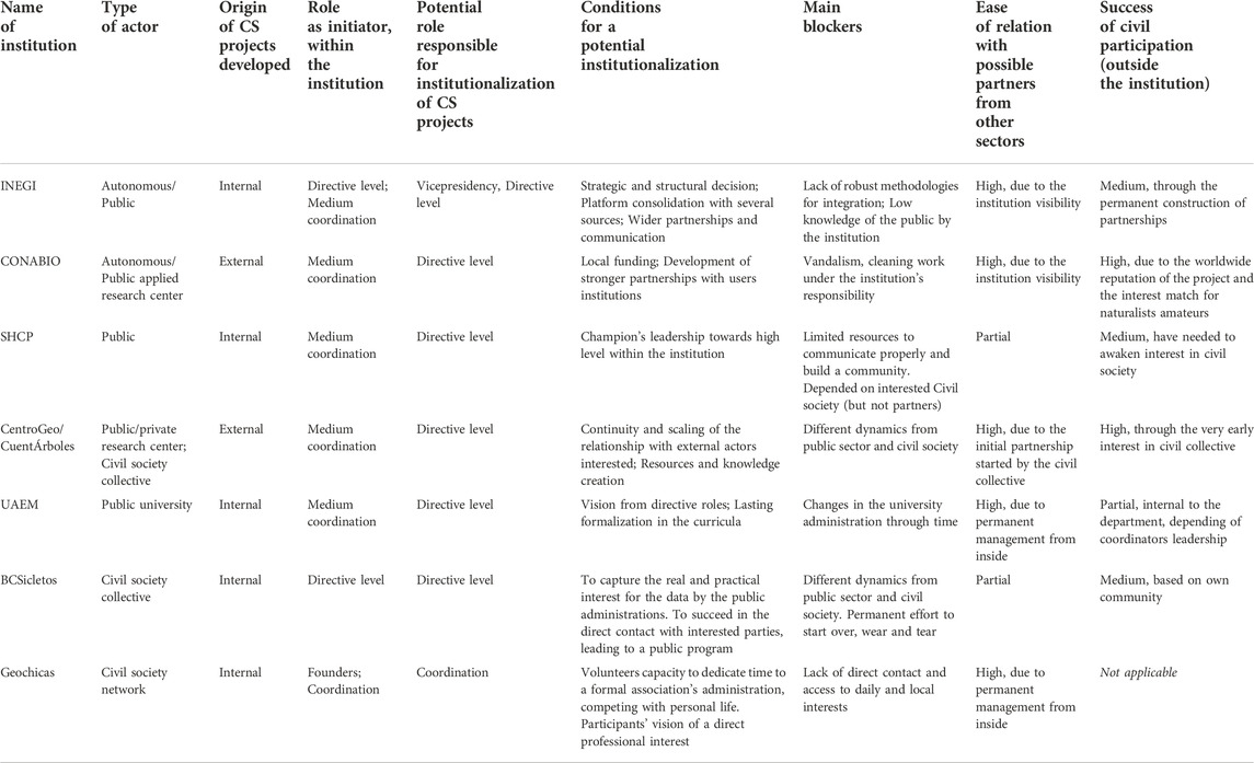
Table 1. Synthesis of the dynamics of emergence and insertion of citizen science in public institutions, based on the present research. Source: authors.
The need for participatory processes can appear internally to the institution (as in the case of INEGI) but really takes off when there is a plural motivation (involving external actors and society). It can come from the understanding of a social trend that can be understood as a need and as an opportunity, or from a direct request from external actors, which becomes relevant if it connects with the institution’s agenda. For instance, a call to the public institution for transparency, a call to expand the impact of science and collective causes by supplementing data sources and evidence-based communication, to improve the range of the institutional mission and its social responsibility, to increase the exposure of innovation strategies and open up business opportunities, or to leverage collaborations that will increase internal competencies and opportunities in the future, etc.
Institutions can also be reached by an external demand of methodological and technical support, giving them a new motivation to accelerate innovation in the field of citizen science. The next step is the development of relevant frameworks and methods to mitigate the possible lack of quality in the information. But the participation of the population is a fundamental ingredient that must be actively maintained over time for the success of the project or strategy. When an institution is not specialized in interaction with the population, it is a difficult dimension to understand and take in charge.
One of the first questions that arise when considering the use of a participatory process where a potential benefit has already been identified, is the real capacity of citizens to provide information in sufficient quantity, frequency, as well as quality. The quantity of the contributions is key to constitute a notable enrichment to traditional sources of information, ensuring that the information validates itself through cross-referencing and repetition (Kosmala et al., 2016). This concern occurs when the potential of crowd-sourcing is manifesting itself to an institution, and the citizens bring data from their experience “on the ground”, without a system or a method in place for this purpose, as in the initial situation of INEGI’s Participative Cartography; or through the intermediation of external actors (organizations, civil society collectives).
Then, the discovery of the potential of citizen participation by the institutions is the turning point that allows conceive a strategy to maintain a participatory process and to imagine connections with existing projects and programs. Building a participatory strategy that can work over the long term requires community collaboration skills and knowledge of the social and political ecosystem involved, and an understanding of the issue from the social sector, which usually extends beyond the scientific institution. In that sense, collaboration with intermediary actors (collectives, organizations, universities, etc.) who have a foothold in this social sector seems to be positive to benefit from pre-existing knowledge and relationships.
By the very fact that projects that include citizen science leave the formally established processes, the motivational dimension of the people who compose it and the clear understanding of the governance framework with which it is related (whether intra-institutional or between civil society and other institutions) is crucial in the development of projects based on participatory data and innovation in general, considering that continuity in the process of collaboration between actors appears as the key to the projects’ consolidation. In the interviews conducted, the reflections in this regard are generally in the form of a retroactive observation of the trajectory. Rather, it seems that strategic thinking about the current and future roles and motivations of participants and stakeholders is needed in the early stages of initiatives.
In this way, developing a framework for citizen participation and engagement that is both ambitious and scalable, and that demonstrates the potential for sustainability over time, was seen as critical to the trust that (even initial) contributors can place in the project. Potential participants will more easily strengthen their interest in the project or in the institution that proposes collaboration, if they can rely on the durability of the initiative and the will to carry it through, with a concrete objective. Doubts in this area will limit the interest or determine a more immediate and pragmatic vision: when the short-term objective is reached, the participation and external leaderships may decrease. Depending on the strategic vision of the project, this situation could be appropriate for the objectives sought. Thus, the framework of participation can variably dose the ingredients that are the methods of valorization, its concrete degree, and the elaboration of a long-term concept, its effective communication, and meaningful partnerships.
On the other hand, maintaining the interest of the people in the project, and the relative renewal of participants seems to avoid its stagnation and the exhaustion of participants this seems to be able to allow a longer commitment, and touches the construction of a sustainability by giving the feeling that the project will be supported for a long time by new participants. Turning a local project into a larger and sustainable movement that becomes a reference point for the public, or gets people talking about it, would also contribute to the symbolic value and satisfaction linked to the identification with a movement, an interest group, a critical mass, a space for learning and would facilitate wider participation.
Therefore, ensuring the main driving force of a citizen science project, participation, is a sine qua none condition for its existence and functioning beyond the concept.
5 Conclusions and recommendations
Through this analysis, we can highlight the key elements mentioned throughout the results section, for an organization to open up to citizen science.
- A frequent contact with spaces where knowledge and innovative experiences are shared, spaces for dissemination and dialogue, allowing all staff to participate.
- An openness and great flexibility in connecting with other actors, understanding their needs and identifying what the institution can develop, identifying niches for innovation. The creation of various and always renewed dialogue schemes to facilitate these contacts with various institutions should encourage and leverage the more organic emergence of ideas and demands by both internal and external actors. A mapping of external and internal stakeholders could be a valuable initial exercise. Even if participatory project development proves to be a mostly spontaneous and progressive process, it can allow for intermediate strategic planning.
- Repeated collaborations with a diversity of stakeholders and sectors, particularly potential end-users but also funders or sponsors, seems a key point to broaden the potential perspectives that can give the greatest possibilities for a project to match multiple needs, as well as allow exposure and deeper stakeholder involvement in the long term.
- Pro-active, timely, broad, motivating, and comprehensive dissemination of the projects and the data produced is not only necessary to achieve correspondence between knowledge and social needs, but also to strengthen the demand and collective awareness around the project object and at long-term, to spread the culture of citizen science in both society and institutions (the own and those of the sector).
- Likewise, the correct recognition of the volunteers’ efforts, not only in the short term but also understanding their deep motivations and allowing their personal growth through the project, is a key to seeing it grow.
- Within the institutions, the common factor is the emergence of “champions” or people who, because of their own philosophy and taste, their activism, knowledge and leadership abilities, come to promote projects that integrate citizen science even without having the position or the conditions within the institution to do so. The success of innovation depends on the capacity of the institution to detect and recognize these people, to give the promoters the means to connect them with the conditions for their realization on the right scale.
- A fine understanding from the middle to the top hierarchy of the organization’s structure and the necessary trigger points, as well as strategic planning seeking for its adoption within the institution, is a key to allowing the project to flourish. The ability to understand the opportunity for paradigm shifts or openness to new social trends that can renew the vision of an institution is a responsibility for the management levels, which ideally are plural and diverse.
On the other hand, the best practices that can be translated into successful mechanisms to activate the citizen science process and its integration within institutions are mentioned below:
- The common feature of the INEGI and academic actors interviewed has been the continuous exchange with other groups interested in crowdsourced data integration. The INEGI has hosted user forums that key leadership steered in the direction of data crowd-sourcing, eventually leading to more successful projects. The institute also participates into international working groups or spaces of dialogue on issues of interest. The challenge is to connect these links with potential internal “champions” who are willing to drive this type of innovation.
- At the CentroGeo, there is a clear avenue for the NGO’s and other local interest groups to directly connect about a problem they wish to combat or projects they wish to collaborate on. While this is a far more organic process, the research center made sure to remain making itself accessible to these groups, maintaining accessible contact and public presence, and to act quickly opportunistically. As we learned from the CuentÁrboles project, CentroGeo is prepared to quickly adapt any prototype-stage projects or plans to foster collaboration. This, in combination with the concerns voiced by many interviewees for changes over time in leadership and interests, highlights the need for cross-cutting groups with resilient structures to focus on strengthening the bond between crowdsourced data and official data.
While this group structure and mode of work may and should be fine-tuned to the needs and goals of each organization/group, a public institution could stimulate such mechanisms towards citizen science integration through these initial elements of proposal:
1. Members selected based on their leadership skills and specialized abilities, as well as on their personal commitment to crowdsourced geospatial data and specific interests, might be involved in a flexible and open creative working group, or a conduct might be created to allow high hierarchy to receive and discuss ideas from the organization independently of the structure. These two elements in conjunction appear to be conducive to the emergence or meeting of champion roles that can greatly benefit any initiative. The figure of champion is crucial to the emergence of ideas and connections, its evolution from experiment to project, and the longevity of initiatives. It is important to join many supporters and collaborators on an idea early on because, since projects may require a significant amount of work that in many cases doesn’t correspond with existing functions, the tasks and responsibilities need to be efficiently distributed. In addition, champions as leaders should continually identify new and motivated members to ensure perennity.
2. Redundancy in membership is strategic. The champions can come from any level. Having several employees from the institution from the same department is positive to push the agenda from different rungs. Based on interviewees contribution, barriers have been met to achieve institution-wide acceptance and adoption when one promoter of a project wasn’t able to transcend a structural barrier. Working with multiple people and positions helps to avoid the dialogue getting stuck, find new channels, avoid burnout, and can foster synergy as opposed to competition among similar NGOs/public interest groups.
3. The “working group” should provide an effective and easily accessible communication and contact method for third organizations, to allow dialogue, gather concerns and new ideas and perspectives. Even when the mechanisms are spontaneous, this channel could be consciously built and maintained over time, also used to inform widely and make open calls.
4. In the same vein, the project group should connect to larger joint think tanks on citizen science in general or in the same sector, locally and internationally, gaining knowledge, methodological approaches, experience sharing and exposure.
5. The goals and requirements, as well as the expectations and capacity of each organization or department represented should be clearly evaluated at early stages and considered into an appropriate project design. Full adherence to these principles is necessary for the initiative to retain its value to organizations. At the same time, the group of actors involved should allow for flexibility if the potential for growth outweighs the cost of compromise, but also flexibility for changes in direction if the context demands it.
6. The working group should have a plan in place to act appropriately based on the political context. As politics and public interest are constantly evolving, there are times when the initiative can benefit from natural inertia, and others when it should take advantage of, or mitigate renewal as appropriate. Any group working on a project that integrates citizen science with the goal of making a lasting impact could involve a variety of actors with diverse structural and temporal characteristics to avoid barriers and maximize the integration of organic opportunities.
7. To each the highest and best use out of all members and organizations represented, labor for the project development should be divided among the organizations and members based on the resources at each of their disposal, the existing regular work within their organization, and their experience and respective platforms. In the CuentÁrboles case, for example, CentroGeo was mostly active in the development stage, while the NGOs collaborating on the project were activated mostly to maintain and to promote it to citizens afterward. Similarly, a public institution should act within its abilities and take advantage of its existing resources. Promotion in the public sector might be better handled by an NGO or public interest group as their regular work is much more rooted in public engagement. This is also an economic measure, as each organization will be better able to work at the speed necessary to weave into regular tasks.
8. The public-facing side of the project for data collection should be carefully designed to be attractive and simple to use, able to involve potentially large and diverse populations.
On an ending note, this document is considered by its authors as an initial contribution on how institutionalizing citizen science. It presented a set of reflections, qualitative analyses, and common mechanisms, on the processes that allow or could increase the benefit of integrating participatory processes in the production of official data. These initial guidelines are based on the synthesis of interviewees’ experience, and the analysis they allowed.
Being reflections based on a limited set of interviews and bearing in mind that the integration of geospatial data by crowd-sourcing is still an innovative topic, the balance between its benefits and the necessary adjustments for its use, still asks to be demonstrated. In this sense, this document should be considered a living document. Readers are invited to contact the authors and share their thoughts on the subject.
This work should be continued by further research on organizations that have had successful experiences from different processes and methods; on initiatives that manage to permeate and consolidate the use of citizen science over time, and to improve the quality of resulting information; on the profiles and motivations of volunteers (some studies have been conducted and can be amplified (Duféal, Jonchères, and Noucher 2016; Truong et al., 2018)); as well as surveys directed to organizations and public institutions for the analysis of the various forms of volunteered data and processes uses.
Data availability statement
The datasets presented in this article are not readily available because The “datasets” are qualitative interviews with professionals, academics, and officials. Interviews were recorded only to facilitate note-taking, analysis, and generalization. The authors do not have permission to share them. Requests to access the datasets should be directed to celija@gmail.com.
Ethics statement
The studies involving human participants were reviewed and approved by INEGI. The participants provided their informed consent to participate in this study.
Author contributions
CJ participated in the design of the research, organized the interviews, helped conduct the interviews, and co-wrote the article. PM participated in the conceptualization of the research and co-wrote the article. VA used an interview guide provided by Arizona State University as a basis, conducted the interviews with CJ, and synthesized a report with key outcome ideas, which was used to compile the first draft.
Acknowledgments
We would like to thank Jean Parcher and Patricia Solis for organizing this collaboration of the Arizona State University and the Panamerican Institute of Geography and History with the INEGI. We warmly thank who have participated in the exploratory interviews: Carmen Reyes, Gerardo Esparza, José Luis Mondragon, Claudio Martínez Topete, Rodolfo Orozco Gálvez, Sandra Corro Mora, Miguel del Avellano, Raul Mejilla, Martin Wilson, Dilek Fraisl, Raul Sierra, Aura Martínez Oriol, Francisco Aguirre Rivera, Alekz Águila, Andrés López Pérez, Loecelia Ruvalcaba, Sandra Hernández Zetina. We thank additionally the final work of AS for her substantial help in the final writing.
Conflict of interest
The authors declare that the research was conducted in the absence of any commercial or financial relationships that could be construed as a potential conflict of interest.
Publisher’s note
All claims expressed in this article are solely those of the authors and do not necessarily represent those of their affiliated organizations, or those of the publisher, the editors and the reviewers. Any product that may be evaluated in this article, or claim that may be made by its manufacturer, is not guaranteed or endorsed by the publisher.
Footnotes
1We voluntarily quote the most popular source of citizen science project, considering that the relevance of its definition can be based on a development based on the collaborative aspect.
2The research is articulated with a larger research program led by Patricia Solis, Jean Parcher Wintemute and Nancy Aguirre for the National Science Foundation within a set of national cases characterized by a range of public access, technologies, and governance configurations in several countries of North and Latin America, where the conditions and barriers to the adoption of crowdsourced data or volunteered-based methods have been observed within national institutes of geography.
3Interviews were led by Vivian Arriaga (degree in Geospatial Science in the Arizona State University) and Céline Jacquin (INEGI; OpenStreetMap México; Geochicas).
4The questions asked, their order, the way they were formulated and their level of detail, has depended for each person on the prior answers given, respecting the natural course of the conversation. The opening questions, if answered around personal experience, made it possible to move on to specific questions and to return to the initial topics when the natural course of the discourse allowed it.
1- Opening questions were asked to provide insight to the respondents’ general perspective, as follows:
-Who produces and consumes crowdsourced spatial data in your country?
- Where, how, and for what purposes has crowd-sourcing data provided any benefit to government agency needs? to citizen concerns?
- What roles do respective actors play, and how do they relate?
- What types of processes enable/prohibit integrated data into official sources of information?
- What determines an acceptable quality and who defines it/how is that defined? What conditions for volunteers lend to/inhibit negotiating better accuracy?
- What is the need for crowdsourced spatial data relative to your country’s public access to official cartographic and geographic data?
2- Specific questions asked when relevant to help interviewees to elaborate:
(1) At what point did you first become aware of citizen science/And about collective collaborative geospatial data?
(2) What specific incident (action, discovery, perception, or event) triggered this awareness?
(3) What happened next? [in reference to the experiences freely mentioned]
(4) What did you (you and/or another person) do around this question?
(5) Why did you decide to do this/What were you thinking when this happened?
(6) What challenges did you get and see?
(7) What results did you get?
5(Anderson et al., 2018; Kashian et al., 2019; Truong et al., 2020).
References
Anderson, J., Soden, R., Keegan, R., Palen, L., and Kenneth, M. A. (2018). The crowd is the territory: Assessing quality in peer-produced spatial data during disasters. Int. J. Human–Computer Interact. 34 (4), 295–310.
Brovelli, M., Ponti, M., Schade, S., and Solís, P. (2020). “Citizen science in support of digital Earth,” in Manual of digital Earth. Editors Huadong Guo, Michael F. Goodchild, and Alessandro Annoni (Singapore: Springer), 593–622.
Brown, E. D., and Williams, B. K. (2019). The potential for citizen science to produce reliable and useful information in ecology. Conserv. Biol. 33 (3), 561–569. doi:10.1111/cobi.13223
Chen, C. W., and Gorski, P. C. (2015). Burnout in social justice and human rights activists: Symptoms, causes and implications. J. Hum. Rights Pract. 7 (3), 366–390. doi:10.1093/jhuman/huv011
Duféal, M., Jonchères, C., and Noucher, M. (2016). ECCE Carto- Des Espaces de la Contribution à la Contribution sur l’Espace - profils, pratiques et valeurs d’engagement des contributeurs d’OpenStreetMap (OSM)., 5319.
Fraisl, D., Campbell, J., See, L., Wehn, U., Wardlaw, J., Gold, M., et al. (2020). Mapping citizen science contributions to the UN sustainable development goals. Sustain. Sci. 15 (6), 1735–1751. doi:10.1007/s11625-020-00833-7
Fritz, S., See, L., Carlson, T., Haklay, M., Oliver, J. L., Fraisl, D., et al. (2019). Citizen science and the united nations sustainable development goals. Nat. Sustain. 2 (10), 922–930. doi:10.1038/s41893-019-0390-3
Graham, M., Straumann, R., and Hogan, B. (2015). Digital divisions of labor and informational magnetism: Mapping participation in Wikipedia. Rochester, NY: Social Science Research Network.
Kashian, Alireza, Rajabifard, Abbas, Richter, Kai-Florian, and Chen, Yiqun (2019). Automatic analysis of positional plausibility for points of interest in OpenStreetMap using coexistence patterns. Int. J. Geogr. Inf. Sci. 33 (7), 1420–1443. doi:10.1080/13658816.2019.1584803
Kosmala, Margaret, Wiggins, Andrea, Swanson, Alexandra, and Simmons, Brooke (2016). Assessing data quality in citizen science. Front. Ecol. Environ. 14 (10), 551–560. doi:10.1002/fee.1436
Neis, Pascal, Goetz, Marcus, and Alexander, Zipf (2012). Towards automatic vandalism detection in OpenStreetMap. ISPRS Int. J. Geo-Information 1 (3), 315–332. doi:10.3390/ijgi1030315
OECD (2020). “Digital government in Mexico: Sustainable and inclusive transformation,” in OECD digital government studies (Paris: OECD Publishing).
Open Government Partnership (2020). “Lessons from reformers: Mexico builds a regulatory ecosystem.” open government partnership. Available at: https://www.opengovpartnership.org/stories/lessons-from-reformers-mexico-builds-a-regulatory-ecosystem/ (Accessed September 15, 2021).
Presidencia de la República (2017). Guía de Implementación de La política de Datos abiertos.” DOF - diario oficial de La federación. Mexico City: Secretaría de Gobernación.
Secretaría de Gobernación de México (2011). ACUERDO por El que Se establece El esquema de Interoperabilidad y de Datos abiertos de La administración pública federal.” DOF - diario oficial de La federación. Mexico City: Secretaría de Gobernación.
Taylor, D. R. (2014). Some recent developments in the theory and practice of cybercartography: Applications in indigenous mapping: An introduction. Mod. Cartogr. Ser. 5, 1–15.
Truong, Q. T., Touya, G., and de Runz, C. (2018). Building social networks in volunteered geographic information communities: What contributor behaviours reveal about crowdsourced data quality. Proceedings of Workshops and Posters at the 13th International Conference on Spatial Information Theory (COSIT 2017). (Cham: Springer International Publishing), 125–131.
Truong, Quy T., Touya, Guillaume, and Runz, Cyril D. (2020). OSMWatchman: Learning how to detect vandalized contributions in OSM using a random forest classifier. ISPRS Int. J. Geo-Information 9 (9), 504. doi:10.3390/ijgi9090504
U.S. Geological Survey (2021). Volunteered geographic information (VGI). Center of Excellence for Geospatial Information Science. Available at: https://www.usgs.gov/center-of-excellence-for-geospatial-information-science-%28cegis%29/volunteered-geographic-information (Accessed September 28, 2021).
Keywords: citizen science, crowdsourcing, Mexico, 2030 agenda, geospatial information, volunteered geographic information (VGI), official cartography, land uses changes
Citation: Jacquin C, Merodio Gómez P, Arriaga V and Santiago A (2023) Citizen science interactions with official geospatial information; Case studies from Mexico. Front. Environ. Sci. 10:800247. doi: 10.3389/fenvs.2022.800247
Received: 25 October 2021; Accepted: 22 August 2022;
Published: 15 February 2023.
Edited by:
Tarla Rai Peterson, The University of Texas at El Paso, United StatesReviewed by:
Anton Eitzinger, International Center for Tropical Agriculture (CIAT), ColombiaLeonardo Candela, National Research Council (CNR), Italy
Copyright © 2023 Jacquin, Merodio Gómez, Arriaga and Santiago. This is an open-access article distributed under the terms of the Creative Commons Attribution License (CC BY). The use, distribution or reproduction in other forums is permitted, provided the original author(s) and the copyright owner(s) are credited and that the original publication in this journal is cited, in accordance with accepted academic practice. No use, distribution or reproduction is permitted which does not comply with these terms.
*Correspondence: Céline Jacquin, celija@gmail.com