A Probabilistic Multi-Source Remote Sensing Approach to Evaluate Extreme Precursory Drought Conditions of a Wildfire Event in Central Chile
 Roberto O. Chávez1,2*
  Miguel E. Castillo-Soto3
  Katherine Traipe1
  Matías Olea1
  José A. Lastra1
  Tomás Quiñones4
- 1Laboratorio de Geo-Información y Percepción Remota, Instituto de Geografía, Pontificia Universidad Católica de Valparaíso, Valparaiso, Chile
- 2Institute of Ecology and Biodiversity (IEB), Santiago, Chile
- 3Laboratorio de Incendios Forestales, Universidad de Chile, Santiago, Chile
- 4Pontificia Universidad Católica de Chile, Santiago, Chile
Forest fires are a major issue worldwide, and especially in Mediterranean ecosystems where the frequency, extension and severity of wildfire events have increased related to longer and more intense droughts. Open access remote sensing and climate datasets make it possible to describe in detail the precursory environmental conditions triggering major fire events under drought conditions. In this study, a probabilistic methodological approach is proposed and tested to evaluate extreme drought conditions prior to the occurrence of a wildfire in Central Chile, an area suffering an unprecedented prolonged drought. Using 21 years of monthly records of gridded climate and remotely sensed vegetation water status data, we detected that vegetation at the ground level, by means of fine and dead fuel moisture (FDFM), and canopy level, by means of the enhanced vegetation index (EVI) were extremely dry for a period of about 8 months prior to the fire event, showing records that fall into the 2.5% of the lowest values recorded in 21 years. These extremely dry conditions of the vegetation, consequence of low air humidity and precipitation, favored the ignition and horizontal and vertical propagation of this major wildfire. Post fire, we found high severity values for the native vegetation affected by the fire, with dNBR values >0.44 3 days after the fire and significant damage to the Mediterranean sclerophyllous and deciduous forest present in the burned area. The proposed probabilistic model is presented as an innovation and an alternative to evaluate not only anomalies of the meteorological and vegetation indices that promote the generation of extreme events, but also how unusual or extreme these conditions are. This is achieved by placing the abnormal values in the context of the reference historical frequency distribution of all available records, in this case, more than 20 years of remote sensing and climate data. This methodology can be widely applied by fire researchers to identify critical precursory fire conditions in different ecosystems and define environmental indicators of fire risk.
Introduction
Studies regarding the characterization of wildfire behavior have experienced a notable increase in recent years concomitant with a rising concern for the increase in the frequency and severity of fires in different regions of the world (Costafreda-Aumedes et al., 2017; Keeley et al., 2008; Roldán-Zamarrón et al., 2006). Such research supports initiatives for the prevention, management and combat of fires and the development of methods for post fire damage evaluation. In addition, it contributes to the design of adequate recovery strategies of different ecosystems. From an ecological point of view, the study of fire behavior in landscapes with permanent disturbances related to forest fires helps to understand the response dynamics of vegetation, for example, in Mediterranean ecosystems (Pausas et al., 2008) such as Central Chile, and in understanding the damage and consequences at different scales of analysis (Keeley et al., 2008). Studies of fire behavior have various antecedents in Chile (Julio, 2007; Fernández et al., 2010; Castillo et al., 2012) as well as in other Mediterranean regions of the world. The results show the close relationship between the vegetation status, climate and climate change and the fire behavior (extension, intensity, and severity) and the implications for recovery (de Luis et al., 2004; Saǧlam et al., 2008; Littell et al., 2010).
In this context, remote sensing time series of different aspects of dead and live vegetation material along with climate records allows us to accurately assess hazard conditions against ignition and fire spread (Castillo et al., 2019). Specifically, optical remote sensing data such as the Enhanced Vegetation Index (EVI), a proxy for green canopy biomass, and radar satellite data such as the fuel and dead fuel moisture (FDFM), a proxy for ground vegetation condition, combined could be good indicators of fire risk since they are linked to fire ignition and propagation at the ground level (FDFM) and canopy level (EVI), characterizing well the horizontal and vertical profile of combustible vegetation. To the best of our knowledge spatially and temporally explicit quantifications (maps) of how extreme these precursory environmental conditions (climate and fuel) of wildfires were have not been conducted so far. In this study, we aim at proposing and testing a probabilistic methodological framework that supports fire experts to answer critical questions such as: is an extreme drought vegetation condition related to a major wildfire? Is it possible to define EVI and FDFM thresholds under which ignition and fire propagation are more likely to occur? Can we flag an “extreme dry vegetation condition” related to a high forest fire risk As a study case, a major wildfire affecting native forests and shrublands in Central Chile was used.
In Chile, forest fires are essentially caused by activities associated with human behavior and, to a lesser extent, by natural causes such as lightning strikes (Castillo et al., 2017). In the case of man-made fires, there are two main causes: the intentionality or premeditated action to cause damage and the irresponsible use of fire (Castillo, 2015). On a broader context, intentionality is also one of the main causes of the frequent wildfires of Mediterranean regions such as Southern Europe, California, Southern Australia and New Zealand (Julio, 2007). Central Chile (Figure 1), which also presents a Mediterranean climate, is characterized by a long dry season that favors the occurrence and spread of fire. Central Chile is also where most of the Chilean population is concentrated, with wildfires being one of the major national environmental issues of the present time. Considering the wildfires officially reported for the period 2000–2021, it is possible to observe a high concentration of fires in Central Chile (Figure 1C) affecting relevant natural ecosystems such as sclerophyllous scrubs and forests, with increasing high extension, intensity and severity (Bowman et al., 2019; Castillo et al., 2014). An unprecedented episode of wildfire events occurred in 2017, when successive fires took place in Central Chile with extreme fire behavior originated by, among other causes, the prolonged drought condition that remains until now (Garreaud et al., 2017), the continuity of extensive areas of forest plantations and the simultaneous occurrence of events that exceeded the response capabilities of fire fighting (Bowman et al., 2019; Castillo et al., 2019). According to studies by the Fire Laboratory of the University of Chile, only in 2017 about 18% of the native sclerophyllous forest was lost in Central Chile due to the “tormenta de fuego” (“fire-storm” event). Consequently, the vulnerability of the vegetation due to the permanent incidence of droughts are causing a sustained increase in the extent and intensity of fires, a situation less frequent in previous decades (Castillo et al., 2020), particularly with regard to the susceptibility of vegetation to ignition and flammability.
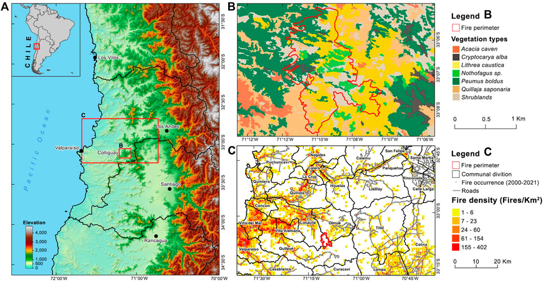
FIGURE 1. Study area. (A) Central Chile and the general location of the Colliguay wildfire (red polygon) where the proposed approach is applied; (B) specific area of the Colliguay wildfire and vegetation types before the event (May 2020); (C) context of high density of wildfires in the surrounding areas of the Colliguay wildfire in Central Chile.
Wildfires have serious consequences on the functioning of ecosystems, even those apparently adapted to frequent fires, such as the sclerophyllous forest and shrublands. Fire can completely destroy large areas of native vegetation, as well as forest plantations, with the consequent impact on ecosystem services and economic damage. It has been reported that fire damage to soils can also be significant; in particular, the remotion of the vegetative layer facilitate the loss of soil due to erosion and the loss of nutrients as a consequence of the formation of layers of hydrophobicity (Garcia-Chevesich et al., 2010; Pausas et al., 2008). Conversely, fire can also act as a selective factor that favors the adaptation of some living organisms, an adaptation that sometimes leads to dependence. In the Mediterranean vegetation of Chile there are several species that exhibit adaptations to fire, among them the Chilean Palm (Jubaea chilensis Mol.), Peumo (Criptocarya alba Mol. Looser), Boldo (Peumus boldus Mol.), Litre (Lithraea caustica Mol.), and Quillay (Quillaja saponaria Mol.) (Gajardo, 1994; Quintanilla Pérez and Reyes C., 1999). Besides fires, the increased fragmentation of landscapes, land use change and the increasing demand for water, has led to an increase in the vulnerability of many species of the native forest of Central Chile.
In this contribution, we present and apply a probabilistic time series analysis approach to assess the prevalent extreme drought conditions (climate records and vegetation status) previous to an specific wildfire event, the Colliguay wildfire in Central Chile. This approach is based on the “npphen” R-package developed to detect anomalies as departures from the most expected annual phenological behavior using time series of a vegetation index, and more interesting, to assess how extreme those anomalies are based on the historical frequency distribution of the index (Chávez et al., 2019; Decuyper et al., 2020, 2022). This approach can be also applied to other datasets with annual recurrence such as precipitation or temperature, which is not done yet. To the best of our knowledge, no previous studies have quantitatively tracked the evolution of the cumulative drying process that made vegetation susceptible to ignition and evaluate how extreme these conditions were based on the historical frequency distribution of the environmental and vegetation variables. Besides our proposed method, we also evaluated, using standard fire assessment methods, the magnitude of the burned area, the different vegetation types affected and the severity of the wildfire event to attempt to relate pre-fire conditions with more severe effects in the territory and explore the definition of environmental indicators of high fire risk.
Materials and Methods
Study Area
According to the website of the National Emergency Office from the Chilean Ministry of the Interior, between May 4th and 19th 2020, a major wildfire occurred in the rural area of Colliguay in Central Chile that affected about 1,700 ha of native forest, shrubs and pastures in the footprint of the Cordillera de la Costa or coastal mountain range (Figures 1A,B). A preliminary field evaluation from the Chilean Forest Service (Conaf) indicated that valuable vegetation locations were affected in the administrative counties (comunas) of Quilpué, Olmué and Lliu-lliu, in which endangered species such as Adesmia recinosa and Nothofagus macrocarpa and also different types of Chilean bromeliads and cacti were present. Part of these areas belong to the La Campaña-Peñuelas UNESCO Biosphere Reserve (Moreira and Troncoso, 2014) and the Priority Conservation Site No. 16 defined by the Chilean Ministry of the Environment. This particular wildfire event was selected to showcase the probabilistic multi-resolution remote sensing approach proposed in this study to assess the environmental conditions and vegetation status previous to the fire. The study area is located mainly in the central massifs of the Cordillera de la Costa, which vary between 1000 and 1700 m above sea level. It has a temperate climate with a prolonged dry season between the months of September-April, reaching average temperatures between 13° and 25° and seasonal rains of short duration.
Climate Records and Vegetation Fuel
To characterize the precursory drought conditions of the Colliguay wildfire, we considered climate variables, i.e., precipitation (PP), temperature (TEMP) and relative humidity (RH), and variables related to the status of vegetation and organic matter at the ground level, by means of fuel and dead fuel moisture (FDFM), and canopy level, by means of the Enhanced Vegetation Index (EVI). All datasets were temporally resampled to monthly values spanning 21 years of records. For each variable and month, the average of all pixels within the study area were considered. This dataset allows us to evaluate the extreme conditions of the months previous to May 2020 (the date the fire took place), and also the previous year (2019), using a long reference period (2000–2018). Monthly 0.05° × 0.05° CR2MET PP and TEMP data were obtained from the Explorador Climático portal from the Center for Climate and Resilience Research (CR2) available at https://explorador.cr2.cl/.RH (%) and FDFM (%) were obtained from NASA-USDA (ERA-5 Sensor) by data resampling, which were processed in Google Earth Engine, following the method of Muñoz-Sabater (2019), at a spatial resolution of 0.1° × 0.1°. This resampling explains the calculation of RH and FDFM from temperature and dew point. In the case of the FDFM, surface and subsurface level data were used, where the dataset is generated by integrating radar satellite-derived soil moisture observations of passive active soil moisture (SMAP) and soil moisture ocean salinity (SMOS) into the modified two-layer Palmer model using the Ensemble Kalman filter (EnKF) data assimilation approach (Muñoz-Sabater, 2019). The metadata used is in the accompanying image. The “SSM” (Surface Soil Moisture) band was used, which is expressed in millimeters. EVI data were obtained from the Moderate Resolution Imaging Spectroradiometer (MODIS) on board the Terra satellite, specifically the MOD13Q1 collection also available at Google Earth Engine. MOD13Q1 composites provide optical data and vegetation indices (NDVI and EVI) at 16 days temporal resolution and 250 m × 250 m spatial resolution. MODIS level 3 images were used which are orthorectified and atmospherically corrected (Didan, 2015).
Probabilistic Assessment of the Extreme Precursory Drought Conditions
Remote sensing time series analysis has great potential to quantify the frequency and extent of disturbances globally (McDowell et al., 2015). However, a main limitation of most available methods is that they lack a reliability measure (de Beurs and Henebry, 2010), i.e., a quality flag indicating the likelihood of a correct disturbance detection. In this paper, we used the “npphen” R package (Chávez et al., 2017) that allows not only anomaly detection of different environmental variables or vegetation indices from remote sensing time series data, but also provides a reliability measure: the position of the abnormal detected value within the reference frequency distribution (RFD) of historical annual records (Chávez et al., 2019). For a detailed discussion about the advantages of this probabilistic approach against parametric time series analysis please refer to Chávez et al. (2019). An example of the use of “npphen” to flag extreme EVI anomalies is provided in Figure 2. The first step is to estimate the expected value of a vegetation index along the growing season using a Kernel Density Estimation (KDE) procedure. If we define the time series of a given vegetation index (VI) as Xi = (Timei, VIi)T, i = 1, … , n, where i is each time step (months in Figure 2), then the bivariate density function of X can be estimated by the following equation:
Where f^(x;H) is the bivariate density function of X, H is the 2 × 2 bandwidth matrix, and K is the kernel. KDE in two dimensions works by centering a bivariate kernel (in this case a Gaussian kernel) and averaging the heights of all kernels till obtaining a final density estimation. The size of the kernel in each dimension is defined by H. For more details about theoretical aspects of KDE see Wand and Jones (1994). In Figure 2, the graphical result of the KDE is shown (Figure 2C) using a time series of EVI records (Figures 2A,B). The reddish areas in Figure 2C highlight the most expected EVI along the year. From this kernel, we can retrieve the annual phenological baseline as the “most expected” EVI value at a given DOY (the dark red line), from which anomalies can be calculated (red arrow) for a given growing season of interest, in this example the year 2019 (see red square and black dots). Additionally, the location of the anomalous observation within the kernel is retrieved. If such observations are outside the 0.95 of the baseline reference frequency distribution (RFD), we are in the presence of an extreme EVI observation. Both EVI anomalies and position in the RFD can be calculated using “npphen” for all pixels of a EVI raster stacks, providing anomaly and RFD maps. RFD maps show where and when extreme anomalies took place (e.g., RFD > 0.95). Following this probabilistic approach, we can detect whether the climate and vegetation condition annual records of the year the fire took place, and the year before, were anomalous and whether they corresponded to an extreme condition. Besides extreme condition, this key output of “npphen” (RFD value) can be used to classify the records of the different variables in user defined categories ranging from “normal values” [e.g., RDF in the range (0–0.50)], “moderately unusual” [e.g., RDF in the range (0.50–0.75)], “very unusual” [e.g., RDF in the range (0.75–0.95)] to “extremely unusual” [e.g., RDF in the range (>0.95)]. Readers can refer to Chávez et al. (2020) to see a monitoring system using different RFD ranges for warning alerts for the La Campana National Park in Central Chile. In this paper, we used as a reference the 2000–2018 period, and consider negative anomalies of the different climate and vegetation condition variables as extreme, when those values were outside the 0.95 of the reference frequency distribution (RFD) considering the historical values at a given time of the year.
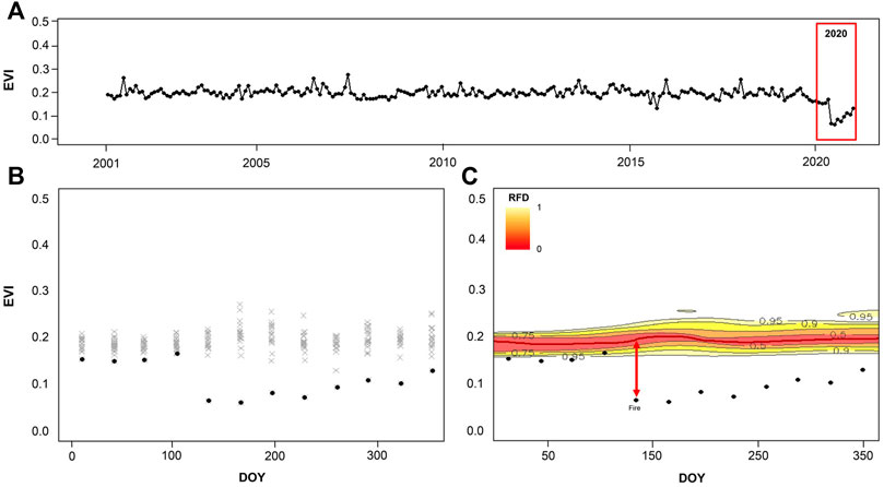
FIGURE 2. The probabilistic “npphen” approach used to detect and quantify precursory extreme environmental conditions of a fire event, in this example, the canopy status given by the Enhanced Vegetation Index (EVI). (A) A time series of a variable of interest, in this example monthly EVI values, is used as input; (B) the multi-year EVI time series is arranged in a scatterplot with the X axis defined as the day of the year (DOY), i.e., 365 days, and the Y axis defined as the EVI dynamic range, i.e., 0–1; and in (C) a kernel density estimation of the EVI-DOY space is calculated (colored areas) where the reddish areas highlight the most expected EVI along the year. From this kernel, the most expected EVI value along the year is defined (dark red line), EVI anomalies are calculated (red arrow) per date and to the position of the observations within the reference frequency distribution (RFD) is obtained, which is an indicator of how extreme the anomaly is (in this study RFD > 0.95 are considered extreme).
Fire Severity Assessment
To evaluate the post-fire severity over the affected area, three Sentinel-2 MSI (2A) images were used. These images are orthorectified and corrected to surface reflectance levels, providing multispectral optical data with 10 × 10 m spatial resolution. The images were downloaded from the ESA European Space Agency’s Copernicus program page (https://scihub.copernicus.eu) and correspond to May 3 (pre-fire), May 23 and September 10 (post-fire). The assessment considered the calculation of the Normalized Burning Index using the SWIR and NIR bands of these optical satellite images (Montorio et al., 2014) before the fire (May 3rd), right after the fire (May 23rd) and 4 months after the fire. The last to evaluate more permanent severity, e.g., burned pastures may recover by September (spring), but not shrubs or trees. The NBR is sensitive to the amount of vegetation loss since recently affected areas show a low reflectance in the NIR band, related to less vegetation biomass and a higher reflectance in the SWIR band, related to less moisture (Montorio et al., 2014). Then the NBR difference between dates is calculated using the following equation.
This way the difference between the spectral responses of the vegetation is measured using the delta of the NBR, the dNBR, to map areas where there was a greater loss of both vegetation and moisture. From the results obtained, we proceeded to classify the dNBR values in severity levels as proposed by Key and Benson (2006) and used in other works like Castillo et al. (2019) or Vidal et al. (2017).
Results
Precursory Drought Conditions of the Fire Event
Figures 3A–E show the time series of 21 years of records of five relevant climate and vegetation condition variables that allows us to assess, in a two-decades context, the conditions prevailing before and after the Colliguay fire of May 2020. By using a graphical function of the “npphen” package, we calculated and displayed the annual RFD of each variable based on the historical records of the period 2000–2018 and the location of the records of 2019 (Figures 3A’–E’) and 2020 (Figures 3A’’–E’’). As expected the annual RFD plots show a marked seasonal behavior of the climate variables with a short and highly variable winter PP, concentrated in 3 months (May-June-July) and mean monthly TEMP going from 15°C (+/−4°C) in winter to 26°C (+/−4°C) in summer. Dry winters with almost null PP are not rare, falling within the 75% RFD. RH (%) is also following a seasonal pattern with summer values of about 75% (+/−8%) and winter values of 87% (+/−8%). The RFD of the FDFM is closely related to RH while EVI is closely following PP, which is expected since water is the limiting factor for plant growth in Mediterranean climates.
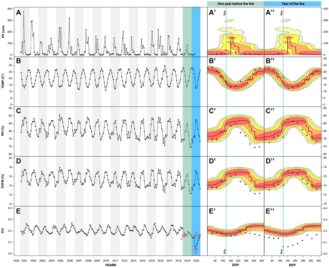
FIGURE 3. Precursory drought conditions before the Colliguay wildfire of May 2020. (A–E) From the top down, monthly time series of precipitation (PP), temperature (TEMP), relative air humidity (RH), fine and dead fuel moisture (FDFM) and Enhanced Vegetation Index (EVI) for the period 2000–2020. The green bar highlights the year prior to the fire event (2019) while the blue bar highlights the year of the fire (2020). The red arrows show specific times at which EVI anomaly maps were carried out and shown in Figure 4. (A’–E’) and (A’’–E’’) show the annual reference frequency distribution (RFD) of the different variables and the values recorded during the year prior to the fire event and the year of the fire event (black dots). Dots outside the colored areas are observations outside the 0.95 of the historical RFD and can be flagged as an extreme negative condition of the given variable.
The precursory drought conditions of 2019 and 2020 showed normal TEMP, with all records within the 0.95 RFD and some months falling inside the 0.5 RFD (Figures 3B’,B’’), while PP was rather low in 2019 with only June showing a high value of about 100 mm (Figures 3A’,A’’). This was the only rainy month of 2019 and 2020 prior to the fire and monthly PP was practically null from July 2019 onwards. Despite this fact, PP records did not underpassed the 0.95 RFD. Contrastly, the months previous to the fire event (starting in august 2019, in the middle of the winter and 9 months before the fire event) showed RH% lower than the 0.95 RFD which can be considered as an extreme dry condition (Figures 3C’,C’’). Concomitant to the low PP and HR, the condition of the vegetation at the ground level was also extremely low, with FDFM values reaching 12% and also falling outside the 0.95 RFD (Figures 3D’,D’’). Finally, at the canopy level and as early as November 2019 (6 months before the fire), green foliage also reached extremely low values, i.e., below the 0.95 RFD (Figures 3E’,E’’). It is remarkable the extremely dry condition of the vegetation foliage, which underpassed the 95% RFD by far in December 2019, almost the same distance in EVI (about 0.04 EVI) than from the 0.95 RFD to the center of the RFD (i.e., 0.45 of the distribution).
Besides EVI, all climate and vegetation condition gridded products are of relatively low spatial resolution, ranging from 0.05° to 0.25°, and therefore only a single time series can be retrieved for our study area. Only 250 m × 250 m MODIS EVI gridded data provides us with the opportunity to spatially assess the water condition of the vegetation canopy in terms of available “green” or photosynthetically active biomass. Figure 4 shows the EVI anomaly maps and the RDF maps for three specific months: 1 year before the fire (April 2019), a month before the fire (April 2020) and a month after the fire (June 2020). To support the interpretation of these maps, readers should consider that the EVI anomaly maps show, on the one hand, the spatial distribution of the intensity of the drought (“green” biomass that dried out and turned “brown”), and the RDF maps, on the other hand, show how unusual or extreme these anomalies are. Readers have also to consider that the 0.95 RDF is centered around the most frequent value (dark-red line), which means that the remaining 0.05 is distributed among the 2.5% of extremely high values and the 2.5% of extremely low values. This way pixels with negative EVI anomalies and RDF > 0.95 in Figure 4 correspond to the 2.5% of the most extremely low values according to 19 years of EVI records. The impact of the increasing drought of 2019 on the vegetation can be visually observed by comparing the EVI anomaly maps of april 2019 and 2020. By april 2020 about 37% of the study area showed low values of green biomass with RDF between 0.75 and 0.95 and about 42% of the study area reached extremely low values of green biomass with RDF > 0.95 (Figures 4B’,B’’). After the fire, the area with RDF > 0.95 increased dramatically, reaching 88% of the study area, showing high EVI anomaly intensities for the entire study site (Figures 4C’,C’’).
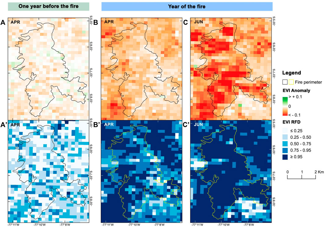
FIGURE 4. Spatial distribution of EVI anomalies (A–C) and their position within the reference frequency distribution (RFD) (A’–C’) based on the 2000–2018 historical records for three moments in time: 1 year before the fire (April 2019, left panels), a month before the fire (April 2020, center panels) and a month after the fire (June 2020, right panels). Dark blue areas show areas where EVI anomalies were extreme, being outside the 0.95 of the historical RFD records (2000–2018).
Vegetation Types Affected by the Fire Event
The study area is located between the sectors of Colliguay, Lliulliu, and Quebrada Alvarado, belonging to the communes of Quilpué, Limache, and Olmué, Valparaíso region, Chile (Figure 1). According to the Forest Cadastre of CONAF (2013) the plant cover of the study area corresponded mainly to sclerophyllous forest, shrubland, and grassland (Table 1). The affected forest presented around 23% of endemism (Arancibia Fortes et al., 2020), and it is being considered a site of interest for conservation due to its quality of biological corridor and consent of biodiversity (MMA ONU Medio Ambiente, 2020).
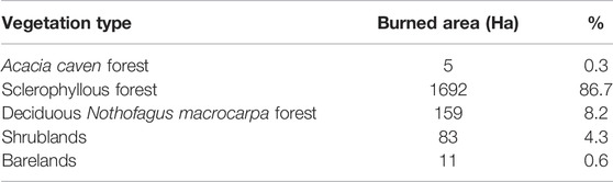
TABLE 1. Burned area according the forest cadaster (CONAF, 2013).
A detailed analysis of the floristic composition of the burned area shows dominance of species from the forest and sclerophyllous scrub. The most affected species correspond to Colliguay (Colliguaja odorifera), Peumo (Cryptocarya alba), Litre (Lithraea caustica), Roble de Santiago (Nothofagus macrocarpa) and Quillay (Quillaja saponaria). These species have a high potential for the spread of fire when they are present in a situation of high load and horizontal continuity, and humidity of the vegetation less than 12% (Castillo, 2015), a condition that was observed in the FDFM before the Colliguay wildfire. These conditions were reviewed and validated according to the cartography of fuel models of the KITRAL System (Castillo et al., 2017) for the period analyzed. Other companion species of the sclerophyllous scrub appeared in lower frequency, density and load, among them Maravilla del campo (Flourensia thurifera) and Quisco (Echinopsis chiloensis).
Fire Severity
After processing the 10 m Sentinel images and obtaining the NBR of May 3, May 23 and September 10th, the dNBR maps were calculated (Figure 5). Figure 5A shows the severity 4 days after the fire, which is represented under the classification of Key and Benson (2006) considering five severity intervals. The results are summarized in Tables 2, 3. Different types of severity can be observed within the affected area, from which the higher severities were distributed mainly in the center and south parts of the study area. Right after the fire, areas with high severity corresponded to a total of 5% of the study area (106 ha), areas with a high moderate severity correspond to 21%, (409 ha) while the areas corresponding to a low or moderately low severity were 53% of the affected area (1,042 ha). Four months later, the general spatial patterns of severity remained but the severity levels changed, showing some degree of recovery (Figure 5B). The areas where the highest severity category is concentrated correspond mainly to Nothofagus macrocarpa forest and sclerophyllous forests with presence of Peumo, Litre, and Quillay.
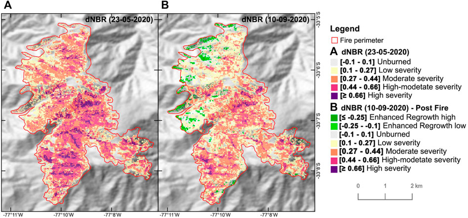
FIGURE 5. Difference Normalized Burn Ratio (dNBR). (A) dNBR between pre-fire image (03-05-2020) and post-fire image (23-05-2020). (B) dNBR between pre-fire image (03-05-2020) and post-fire image (10-09-2020).
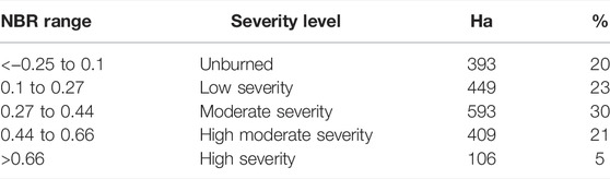
TABLE 2. Fire severity by 23/05/2020 according to the classification by Key and Benson (2006).
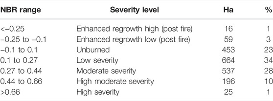
TABLE 3. Fire severity by 10/09/2020 according to the classification by Key and Benson (2006).
Discussion
The behavior of fire, defined as the set of physical, chemical, and mechanical effects that are observed in the environment affected by the fire, depends essentially on the availability or load of fuel on the forest floor and on the calorific value (potential energy) and propagation potential of this fuel (Castillo and Plaza, 2021). These conditions vary according to the type of vegetation. In the case of the research area, the predominance of native bushes and trees is related to high values of fire intensity in terms of caloric release, it has been shown by Castillo et al. (2017) who updated the fire parameters for different situations of forest and scrub in areas of high recurrence of forest fires. However, the severity, measured by dNBR differences, shows intermediate values that can be related to a shorter time of permanence of the flame compared to sectors with greater severity. This is mainly due to the action of wind, which in the research area presents significant fluctuations in speed and direction (Castillo et al., 2020). The topographic effect of the slope directly influences the speed and direction of advance of the flames, but in the case of this fire, there were no significant differences between the different sectors classified in the severity scale of Key and Benson (2006).
The wildfire hazard depends, among other factors, on the fuel moisture content of fine and dead vegetation (Castillo, 2015). This indicator depends, in turn, on the air relative humidity and temperature. This makes it possible to construct mathematical equations that allow evaluating this air humidity content in particularly risky meteorological conditions (e.g., during summer droughts), and estimate the vegetation water condition when these unfavorable drought conditions are sustained over prolonged time. A decreased vegetation water content is negatively influencing the photosynthetic activity of plants due to stomata closure to avoid excessive water loss. For a longer time, this causes green canopy loss. From the satellite data, and for the particular case of the Colliguay wildfire, this was evidenced by the EVI, which declined sharply from July 2019 on, a process that favored the fire ignition.
The moisture content of vegetation is considered a cumulative variable closely related to the danger of forest fire propagation (Castillo et al., 2012). Indeed, episodes of water stress in the summer period promote the predisposition to the initial ignition when the ignition factor occurs (Julio, 2007). These conditions are present in practically the entire distribution of Central Chile vegetation, accentuated by climate change and the increase in water demand for other land uses (Castillo, 2015). In local terms, the behavior of the fire can be evaluated by means of the intensity or amount of heat energy that the fire is capable to develop under certain meteorological conditions regulated air temperature and the local wind, as well as by the topographical conditions that regulate the height and tilt of the flames. In terms of energy, experiments carried out by Castillo (2013) in field sampling plots located in the Valparaíso Region (Chile) and dominated by native scrub vegetation, report intensities greater than 1,500 kcal m−1 s−1 with a medium load of 25 ton ha−1, very common values in high-density plant formations in the horizontal and vertical strata. These average values are analyzed considering a total fuel consumption at 1.5 m from the ground. The calorific value developed by the analyzed fuel model and its propagation potential allow knowing this intensity at different times of flame development under different topographical conditions and wind intensity and direction. The consequences of fire behavior are subsequently evaluated by severity. In our experiment, the values reported for the Colliguay fire show higher concentrations of damage associated with dense vegetation of Litre (Lithraea caustica) and Quillay (Quillaja saponaria), evidence that coincides with the fire scars found in scrub and sclerophyllous forest fires, for example in Viña del Mar area, very close to the research area (Castillo et al., 2012). The trends in the decrease in moisture condition of the FDFM are expressed in the landscapes of native vegetation through a change in greenness and a gradual decrease in the percentage of live crown, aspects that have been evaluated through NDVI and EVI time series analysis. This condition of drought in plant tissues and decreased greenness in plants has remained relatively constant, even before 2017 when the large forest fires occurred in Central Chile.
One of the direct applications of this probabilistic approach is the possibility of significantly reinforcing the early warning system in areas of high danger of forest fires. The proposed approach provides a quantitative tool to identify, from a family of environmental variables and fuel condition indicators, which one(s) is(are) critical to explain the fire ignition or fire severity. In water limited ecosystems such as the sclerophyll forests and shrublands of our study site, extreme drought was critical to explain the fire event. Nevertheless, the variable TEMP was not especially extreme before the fire while PP, HR, EVI, and FDFM were extremely low. Besides, not all of these precursory factors showed extreme values simultaneously in time. Indeed HR and FDFM were extremely low the growing season previous to the one the fire took place and only EVI showed cumulative negative effect throughout the last two growing seasons before the fire. These antecedents could complement the current preventive systems that are applied in areas with high vulnerability, especially those associated with the proximity of areas with special ecological value and also in areas of the urban-forest interface. Such vulnerable conditions are predominant in Central Chile and other Mediterranean regions worldwide.
Conclusion
Extreme precursory drought conditions triggered a major wildfire in the Colliguay sector (Central Chile) affecting 1,700 ha of relevant Mediterranean sclerophyllous and Nothofagus deciduous forests between May 4th and 19th 2020. The proposed probabilistic approach supported the detection and assessment of extreme conditions before the fire, especially regarding the vegetation status at the ground (FDFM) and canopy level (EVI) with values among the 2.5% of the lowest values recorded in 21 years of satellite records. This probabilistic algorithm evidenced extreme FDFM and EVI anomalies (RFD > 0.95) about 8 months before the Colliguay fire started, and therefore, it could be used as a monitoring tool to indicate high risk of intense fires in this mediterranean ecosystem. The cumulative effect of drought directly influences the EVI anomaly intensity and RDF, an indicator of how extreme the condition is, which are related to severe fire, especially in those areas where there is a larger load of combustible vegetation. Indeed, wider availability of fuel with low moisture content promotes a major release of energy in the combustion process, which is expressed in a larger difference in the dNBR index. The evaluation of the extreme precursory drought condition using “npphen” and multiresolution climate and vegetation satellite information introduced in this study constitute a methodology with potential for expanding the knowledge on the relationships between meteorological variables and the phenological condition of the vegetation. In practice, this methodological approach extreme anomaly detection of relevant environmental variables along with a quality flag that is directly related to the occurrence and spread of forest fires. It is also possible to relate more precisely key variables of fire behavior and the effect on vegetation through the study of satellite derived severity maps.
Data Availability Statement
The raw data and scripts supporting the results and conclusions of this article are available at https://github.com/labGRS/Frontiers_fire, without undue reservation.
Author Contributions
RC and MC-S conceived the research article. RC, KT, TQ, JAL, and MO developed the GEE and R code for the remote sensing analyses. RC, MC-S, KT, and MO prepared and edited the manuscript. RC, MC-S, KT, and MO conceived and prepared the figures. All authors have revised and approved the manuscript.
Funding
RC was funded by FONDECYT regular N° 1211924, N°1201714 and Grant ANID PIA/BASAL FB210006.
Conflict of Interest
The authors declare that the research was conducted in the absence of any commercial or financial relationships that could be construed as a potential conflict of interest.
Publisher’s Note
All claims expressed in this article are solely those of the authors and do not necessarily represent those of their affiliated organizations, or those of the publisher, the editors and the reviewers. Any product that may be evaluated in this article, or claim that may be made by its manufacturer, is not guaranteed or endorsed by the publisher.
References
Arancibia Fortes, J., Araya Silva, J. L., and Zunino Mardones, D. (2020). Análisis vegetacional del bosque nativo en la región mediterránea de la zona central de Chile: zona de estudio valle de Colliguay. Investig. Geogr. 59, 105. doi:10.5354/0719-5370.2020.55371
Bowman, D. M. J. S., Moreira-Muñoz, A., Kolden, C. A., Chávez, R. O., Muñoz, A. A., Salinas, F., et al. (2019). Human-environmental Drivers and Impacts of the Globally Extreme 2017 Chilean Fires. Ambio 48 (4), 350–362. doi:10.1007/s13280-018-1084-1
Castillo, M. C., and Plaza, A. (2021). Proposals of Rehabilitation and Management Actions for the protection of Sclerophyllous Forests Affected by forest Fires. Forestist 1, 1. doi:10.5152/forestist.2021.21029
Castillo, M. (2015). “Diagnosis of forest Fires in Chile,” in Wildland Fires: A Worldwide Reality (United Kingdom: Nova Science Publishers), 211–223. Available at: https://www.scopus.com/inward/record.uri?eid=2-s2.0-84956831966&partnerID=40&md5=f7a8cdcccdc76b6fdcf1b8894b588989.
Castillo, M. E., Molina, J. R., Rodríguez y Silva, F., García-Chevesich, P., and Garfias, R. (2017). A System to Evaluate Fire Impacts from Simulated Fire Behavior in Mediterranean Areas of Central Chile. Sci. Total Environ. 579, 1410–1418. doi:10.1016/j.scitotenv.2016.11.139
Castillo, M., Garfias S, R., Julio A, G., and Gonzáles, R. L. (2012). Análisis de grandes incendios forestales en la vegetación nativa de Chile. Interciencia 37 (11).
Castillo, M. (2013). “Integración de variables y criterios territoriales como apoyo a la protección contra incendios forestales Área piloto: Valparaíso – Chile Central,” in Tesis Doctoral. Universidad de Córdoba. Escuela Técnica Superior de Ingenieros Agrónomos y de Montes. Córdoba – España (Cordoba: Universidad de Cordoba), 1–247p.
Castillo, M., Julio, G., and Garfias, R. (2014). “Current Status of Risk and Prognosis of forest Fires in Chile,” in Progress and Future Challenges Wildfire Hazards, Risks and Disasters (Amsterdam: Elsevier), 59–75.
Castillo, M., Plaza, A., and Garfias, R. (2020). A Recent Review of Fire Behavior and Fire Effects on Native Vegetation in Central Chile.Glob. Ecol. Conserv. 24, e01210. doi:10.1016/j.gecco.2020.e01210
Castillo S., M., Saavedra S., J., and Brull B., J. (2019). Fire Severity in Mega Wildfires in Chile in 2017: Actions to Improve the protection System. Territorium 26 (I), 5–18. doi:10.14195/1647-7723_26-1_1
Chávez, R. O., Estay, S. A., and Riquelme, G. (2017). Npphen. Vegetation Phenological Cycle and Anomaly Detection Using Remote Sensing DataUACH, PUCV, Chile.
Chávez, R. O., Lastra, J. A., Valencia, D., and Diaz-Hormazabal, I. (2020). A User-Friendly Remote-Sensing Web-Platform for Biodiversity Conservation and Management in Protected Areas.” in 2020 IEEE Latin American GRSS & ISPRS Remote Sensing Conference, Santiago, Chile, March 22–26, 2020. Santiago, Chila: IEEE, 302. doi:10.1109/LAGIRS48042.2020.9165604
Chávez, R., Rocco, R., Gutiérrez, Á., Dörner, M., and Estay, S. (2019). A Self-Calibrated Non-parametric Time Series Analysis Approach for Assessing Insect Defoliation of Broad-Leaved Deciduous Nothofagus Pumilio Forests. Remote Sensing 11 (2), 204. doi:10.3390/rs11020204
Conaf, (2013). Catastro y Actualización de los Recursos Vegetacionales y Uso de la Tierra de la Región de Valparaíso 2013. Available at: https://ide.minagri.gob.cl/geoweb/2019/11/22/planificacion-catastral/ (Accessed February 1, 2022).
Costafreda-Aumedes, S., Comas, C., and Vega-Garcia, C. (2017). Human-caused Fire Occurrence Modelling in Perspective: A Review. Int. J. Wildland Fire 26 (12), 983–998. doi:10.1071/WF17026
de Beurs, K. M., and Henebry, G. M. (2010). “Spatio-Temporal Statistical Methods for Modelling Land Surface Phenology,” in Phenological Research (Springer Netherlands), 177–208. doi:10.1007/978-90-481-3335-2_9
de Luis, M., Baeza, M. J., Raventós, J., and González-Hidalgo, J. C. (2004). Fuel Characteristics and Fire Behaviour in Mature Mediterranean Gorse Shrublands. Int. J. Wildland Fire 13 (1), 79–87. doi:10.1071/WF03005
Decuyper, M., Chávez, R. O., Čufar, K., Estay, S. A., Clevers, J. G. P. W., Prislan, P., et al. (2020). Spatio-temporal Assessment of Beech Growth in Relation to Climate Extremes in Slovenia - an Integrated Approach Using Remote Sensing and Tree-Ring Data. Agric. For. Meteorology 287, 107925. doi:10.1016/j.agrformet.2020.107925
Decuyper, M., Chávez, R. O., Lohbeck, M., Lastra, J. A., Tsendbazar, N., Hackländer, J., et al. (2022). Continuous Monitoring of forest Change Dynamics with Satellite Time Series. Remote Sensing Environ. 269, 112829. doi:10.1016/j.rse.2021.112829
Didan, K. (2015). MOD13Q1 MODIS/Terra Vegetation Indices 16-Day L3 Global 250m SIN Grid V006 [Data Set]. NASA EOSDIS Land Process. DAAC. doi:10.5067/MODIS/MOD13Q1.006
Fernández, I., Morales, N., Olivares, L., Salvatierra, J., Gómez, M., and Montenegro, G. (2010). Restauración ecológica para ecosistemas nativos afectados por incendios forestales. Santiago, Chile: Pontificia Universidad Católica de Chile & Corporacion Nacional Forestal.
Gajardo, R. (1994). La vegetación natural de Chile. Clasifiación y distribución geográfica, 0. Santiago, Chile: Anales de la Universidad de Chile.
Garcia-Chevesich, P., Pizarro, R., Stropki, C. L., Ramirez de Arellano, P., Ffolliott, P. F., Debano, L. F., et al. (2010). Formation of post-fire Water-Repellent Layers in Monterrey pine (Pinus Radiata D. Don) Plantations in South-central Chile. J. Soil Sci. Plant Nutr. 10 (4), 399–406. doi:10.4067/S0718-95162010000200001
Garreaud, R. D., Alvarez-Garreton, C., Barichivich, J., Boisier, J. P., Christie, D., Galleguillos, M., et al. (2017). The 2010-2015 Megadrought in central Chile: Impacts on Regional Hydroclimate and Vegetation. Hydrol. Earth Syst. Sci. 21 (12), 6307–6327. doi:10.5194/hess-21-6307-2017
Julio, G. (2007). Formulación de Lineamientos Políticos y Estratégicos para la Protección contra Incendios Forestales en Chile.
Keeley, J. E., Brennan, T., and Pfaff, A. H. (2008). Fire Severity and Ecosytem Responses Following crown Fires in California Shrublands. Ecol. Appl. 18 (6), 1530–1546. doi:10.1890/07-0836.1
Key, C. H., and Benson, N. C. (2006). “Landscape Assessment (LA) Sampling and Analysis Methods,” in USDA Forest Service - General Technical Report RMRS-GTR. (Issues 164 RMRS-GTR). Fort Collins, CO: Department of Agriculture.
Littell, J. S., Oneil, E. E., McKenzie, D., Hicke, J. A., Lutz, J. A., Norheim, R. A., et al. (2010). Forest Ecosystems, Disturbance, and Climatic Change in Washington State, USA. Climatic Change 102 (1–2), 129–158. doi:10.1007/s10584-010-9858-x
McDowell, N. G., Coops, N. C., Beck, P. S. A., Chambers, J. Q., Gangodagamage, C., Hicke, J. A., et al. (2015). Global Satellite Monitoring of Climate-Induced Vegetation Disturbances. Trends Plant Sci. 20 (2), 114–123. doi:10.1016/j.tplants.2014.10.008
MMAONU Medio Ambiente (2020). “Planificación Ecológica a Escala Local Y Regional: Guía Metodológica. Encargado a: Dr. Alexis Vásquez, Dr. Emanuel Giannotti, Dr. Álvaro G. Gutiérrez, Dr. Ezio Costa, Elizabeth Galdámez, Ms,” in Ignacio Núñez, Camila Muñoz, Aaron Hebel, Macarena Martinic y Héctor Yáñez. Facultad de Arquitectura y Urbanismo, Universidad de Chile. Financiado en el marco del proyecto GEFSEC ID 5135 ministerio del Medio Ambiente - ONU Medio Ambiente (Santiago, Chile: ONU Medio Ambiente).
Montorio, R., Pérez-Cabello, F., García-Martín, A., Vlassova, L., and de la Riva, J. (2014). “La severidad del fuego: revisión de conceptos, métodos y efectos ambientales,” in Geoecología, Cambio Ambiental Y Paisaje: Homenaje Al Profesor José María García Ruiz. (La Rioja, España: Universidad de La Rioja).
Moreira, A., and Troncoso, J. (2014). Representatividad biogeográfica de las Reservas de la Biosfera de Chile. Santiago, Chile: Reservas de La Biósfera de Chile - Laboratorios Para La Sustentabilidad.
Muñoz Sabater, J. (2019). ERA5-Land Hourly Data from 1981 to Present. Copernicus Climate Change Service (C3S) Climate Data Store (CDS). doi:10.24381/cds.e2161bac
Pausas, J. G., Llovet, J., Rodrigo, A., and Vallejo, R. (2008). Are Wildfires a Disaster in the Mediterranean basin? - A Review. Int. J. Wildland Fire 17 (Issue 6), 713. doi:10.1071/WF07151
Quintanilla Pérez, V., and Reyes, C., C. (1999). Modificaciones por efecto del fuego en el bosque esclerófilo de quebradas húmedas de Chile Central y su incidencia en la palma chilena. Santiago, Chile: Revista Geográfica de Chile Terra Australis.
Roldán-Zamarrón, A., Merino-de-Miguel, S., González-Alonso, F., García-Gigorro, S., and Cuevas, J. M. (2006). Minas de Riotinto (south Spain) forest fire: Burned area assessment and fire severity mapping using Landsat 5-TM, Envisat-MERIS, and Terra-MODIS postfire images. J. Geophys. Res. 111 (4), 136. doi:10.1029/2005JG000136
Saǧlam, B., Küçük, Ö., Bilgili, E., Durmaz, B. D., and Baysal, I. (2008). Estimating Fuel Biomass of Some Shrub Species (Maquis) in Turkey. Turkish J. Agric. For. 32 (4), 12. doi:10.3906/tar-0801-12
Vidal, P., de Santis, A., Pérez, W., and Honeyman, P. (2017). Uso de herramientas de teledetección para el análisis de la severidad y estimación de gases de efecto invernadero (GEI) en incendios forestales de gran magnitud. Estudio de caso incendio La Rufina, VI Región del L. G. B. O'Higgins, Chile. Rev. Teledetec. 50, 59. doi:10.4995/raet.2017.8987
Keywords: npphen, satellite, time series, climate change, wildfires
Citation: Chávez RO, Castillo-Soto ME, Traipe K, Olea M, Lastra JA and Quiñones T (2022) A Probabilistic Multi-Source Remote Sensing Approach to Evaluate Extreme Precursory Drought Conditions of a Wildfire Event in Central Chile. Front. Environ. Sci. 10:865406. doi: 10.3389/fenvs.2022.865406
Received: 29 January 2022; Accepted: 29 March 2022;
Published: 04 May 2022.
Edited by:
Pasquale Imperatore, National Research Council (CNR), ItalyReviewed by:
Yosio Edemir Shimabukuro, National Institute of Space Research (INPE), BrazilAlessio Di Simone, University of Naples Federico II, Italy
Copyright © 2022 Chávez, Castillo-Soto, Traipe, Olea, Lastra and Quiñones. This is an open-access article distributed under the terms of the Creative Commons Attribution License (CC BY). The use, distribution or reproduction in other forums is permitted, provided the original author(s) and the copyright owner(s) are credited and that the original publication in this journal is cited, in accordance with accepted academic practice. No use, distribution or reproduction is permitted which does not comply with these terms.
*Correspondence: Roberto O. Chávez, roberto.chavez@pucv.cl