Rural transformation and differential vulnerability: Exploring adaptation strategies to water scarcity in the Aculeo Lake basin (Chile)
 Anahi Ocampo-Melgar
 Pilar Barria
 Cristian Chadwick2
 - 1Facultad de Ciencias Forestales y de la Conservación de la Naturaleza, University of Chile, Santiago, Chile
- 2Facultad de Ingeniería y Ciencias, Adolfo Ibáñez University, Santiago, Chile
The way of life of agricultural rural territories and their long-term capacity to adapt to changes will be challenged not only by the impacts of climate change; but by increased vulnerability stemming from previous inadequate climate adaptations and development policies. Studies that deepen understanding of the differential causes and implications of vulnerabilities will improve adaptation or transformation of institutions for climate change. The Aculeo basin of Central Chile suffered an extreme 10-years rainfall deficit that resulted in the disappearance of a 12 km2 lake and the economic transformation of the territory. This paper presents a cross-scale exploration of the political, cultural and historical interconnections behind this dramatic story, while critically discussing whether today’s land use configuration reflects the territory’s adaptive capacity. The story is reconstructed using land-use change analysis along with literature review and Causal-Loop Analysis. Results show how previous policies and other human factors contributed to the agroecosystem transformation, creating different vulnerabilities in different economic sectors. Today, what is observed as disparate capacities to adapt to climatic drought is actually the result of historic exacerbations of the vulnerabilities that had significantly contributed to the water scarcity crisis.
Introduction
The impact of climate change on the average frequency and intensity of climate events worldwide (Milly et al., 2008; Milly et al., 2015) is a challenge for agricultural livelihoods (Gitz et al., 2016). This is especially true for traditional rural economic activities and occupations that primarily rely on rainfall for production (Altieri and Nicholls, 2008; Perch, 2011; Delgado et al., 2015). Given that rural productivity is the basis for food security worldwide, adaptation of rural economic activities and way of life to the impacts of climate variability and change is of global importance (Liverman and Ericksen, 2009; Ericksen et al., 2010).
Fostering adaptive capacity, understood as the ability of a resource governance system to change processes and/or convert structural elements as a response to experienced or expected social environmental changes (Pahl-Wostl, 2006), will be key for adaptation. Adaptation then is also about peoples’ capacity to learn, innovate by combining knowledge and experience, and adjust institutions to changing external drivers and internal processes (Folke et al., 2002; Folke, 2016). However, the ability to adjust institutions to be able to change may not necessarily be possible, nor lead to sustainability for all the actors, as there are a variety of existing factors interacting disproportionately with people’s vulnerabilities, resulting in unintended outcomes even under similar climatic problems (Turner et al., 2003; Fraser et al., 2011). This is especially important in water crises as these are complex problems resulting from combination of factors and affecting unequally multiple actors (Trimble et al., 2021), and as there are increasing examples of desiccation events which include Lake Urmia, related to either anthropogenic (AghaKouchak et al., 2015; Alizade Govarchin Ghale et al., 2018) or climatic causes (Arkian et al., 2018; Fathian et al., 2015), Lake Mogan in Turkey, where the combination of climate and anthropic changes exacerbated detrimental water quantity and quality conditions (Coppens et al., 2020), as well high Andeans wetlands vulnerability to climate change (De la Fuente and Meruane, 2017).
The implementation of rules to adjust institutions for a drier world where the less than the historic average precipitation is not an event, but the normal condition; requires understanding complexity, as well as facing with a common-pool resource problem (Ostrom, 2005). Unless it is carried out based on a long-term and holistic understanding of the social and environmental interconnections, implementation of short-term coping strategies to some sectors will not necessarily enhance the long-term adaptive capacity of a rural territory as a whole (Morton, 2007; Massey et al., 2015). Fostering sustainable development along with adaptive capacity to climate variability and change requires a deeper understanding of the complex factors on the global and local scale that influence different degrees of vulnerability (e.g., national economic policies, regional development projects, local migration to urban areas, etc.). As a result of a poorly understood social-ecological context and its differential vulnerabilities, an adaptation strategy can result in maladaptation (Eriksen et al., 2015), i.e. a short term initiative that will affect long-term capacity and opportunities of large territories, economic sectors, and people to cope with and manage the impacts of climate change (Magnan et al., 2016); or the transformation of an agroecosystem, that can mean the disappearance of those less prepared to cope with changes.
The cross-scale interactions between adaptation strategies, vulnerabilities, and their impact on overall sustainability is the focus of this article. The objective of this study is to showcase a story of change in the agricultural economy of a small basin as it endured a severe drought. In this small basin in Central Chile, an extreme 10-years rainfall deficit resulted not only in the disappearance of an important freshwater ecosystem (the Aculeo Lake), but also in the transformation of a socioeconomic and rural way of life in this formerly productive basin (Barría et al., 2021a). Assessing the “determinants” of adaptive capacity, or the overall capacity of a system to endure changes, has been recognized as a major challenge since it is a latent characteristic, an ability to act in the future, there is no physical outcome that can be measured (Smit and Wandel, 2006). An approach is to document the ways in which the system or community experiences changing conditions and the decision-making processes in this system (or that influence the system) that can accommodate adaptations or provide means to improve adaptive capacity (Smit and Wandel, 2006). This article follows this approach, as it aims to describe the processes interacting at the same time as the climate event and observe “who” was able to endure the change, and how was that possible. After 10 years of drought, which economic sectors have disappeared? Can we say this constitutes “adaptation” in the Aculeo basin? Furthermore, what precedent could this story of transformation set for adaptation policies in rural regions of Chile facing similar climatic challenges? And, how important is to understand everything that is happening besides the rainfall reduction to 1) avoid implementing policies that will decrease peoples’ capacity to endure the climate change, and 2) avoid increasing climate change impact in the biophysical system? In order to explore this sustainable adaptation challenge for agroecosystems in Chile, this study uses historical information, land use/land cover (LULC) change analysis and interviews with local stakeholders to better identify the direct (e.g. groundwater depletion) and indirect drivers (e.g. market prices) that influenced in the vulnerabilities of the different economic sectors in the Aculeo Lake basin. With this article we aim to contribute to the integrated analysis of adaptation as a process that can should be both traced to past and future decisions on the territory.
As there is a large diversity of opinions regarding what constitutes adaptive capacity (Siders, 2019), we won´t discuss whether an observed strategy may prove the legitimacy of a coping strategy (i.e. short-term capacity to endure changes) or adaptive capacity (i.e. long-term capacity to adapt or change in the face of a challenge). Instead, in this study, we are saying that the fact that an economic actor is still producing after 10 years of less than average rainfall, lake desiccation and aquifer depletion, can be used as proxy for a larger capacity to adapt to change compared to those that had to sell their former agricultural land. Then, the disappearance of an economic actor will be used as a proxy of vulnerability; or the contrary, their persistence as proof of adaptive capacity to endure changes during a challenging period (10-years drought causing a decrease in rainfall). The Aculeo Lake case is presented as a critical example of what dissimilar vulnerabilities could potentially mean in rural Chile and in many rural regions of Latin America facing water scarcity, if we do not consider them while promoting not only adaptation policies, but climate-friendly economic policies (Warner et al., 2020; Perreault, 2020). If the many variables that reinforces the structure of appropriation, patterns of interactions among appropriators and outcomes are not recognized (Ostrom, 2005), the future of rural communities in Chile will be difficult.
Study site
The Aculeo Lake basin is a 149 km2 sub basin of the Maipo River (15,381 km2), located in Paine County, 50 km south of Santiago, Chile’s capital city (Figure 1). Several ravines or creeks, as well as artificial detours for agriculture, conduct surface water runoff from the upper basin (2000 m. a.s.l.) into Aculeo Lake (350 m. a.s.l.) in the middle of the valley. Historically, agriculture and livestock production have been the main economic activities in this valley since around 1,660, when this was a large private estate (hacienda), operated by inquilinos or tenants, who included peasants and their families living under the estate owner’s rules (Carrasco, 2017). The Aculeo basin has been drastically altered for irrigation purposes as early as 1900, changing the natural inflow and outflow drainage of the lake to support an economy based in agriculture.
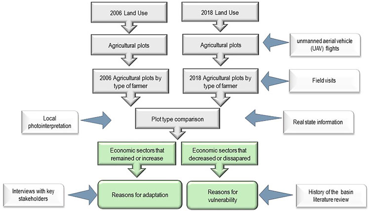
FIGURE 1. Combination of land use change analysis and source of information that were used better understand the direct and indirect drivers that re-configured this basin while the water scarcity problem was in process.
In all rural Chile, the first Agrarian Reform Law No. 15,020 of 1962 redistributed estate lands among peasants, a process that continued for a decade (Órdenes and Díaz-Diego, 2018). By the end of 1972 many of the large estate owners (latifundistas) demanded that the Agrarian Reform Corporation (CORA in Spanish) conduct a pacific expropriation, leaving them part of the properties. This process was abruptly stopped with the military coup of 11 September 1973 (Carrasco, 2017). During the military government regime that ended in 1989, Chile went through deep structural changes in property regimes and social class structure that completed the transformation from an old agrarian oligarchy into free market capitalism (Bellisario, 2007).
Water was one of the natural resources affected by these changes. Today, water in Chile is a commodity freely tradable as water shares on the market, a separate entity from real estate. New water rights can be freely requested and are granted by the National Water Directorate (DGA in Spanish), as long as there is availability (Bauer, 2004; Madaleno and Gurovich, 2007). Chilean water market system has been extensively studied as it is an internationally example of strong private property rights, weak government regulation (Bauer, 2015) and highly uneven power relations (Budds 2009). Water use rights (WURs) were initially allocated among users, with poorly consideration of traditional and indigenous water uses (Prieto 2017). Following the approval of the Water Code, successive WURs have been granted at no cost by Dirección General de Aguas (Chilean Water Directorate, DGA) to any solicitor depending on a theoretical estimation of water availability in each basin and registered under the solicitor in the Real State Title Offices as an immovable good with perpetual private property (Bauer, 2004). Main results have shown the outcomes of its implementation in all basins regardless water availability have been water accumulation, scarcity, environmental degradation (Prieto et al., 2019) and conflicts (Bauer, 2015). Critiques go from: 1) the market system allowing trade of WURs granted without any government control on price and consideration of other uses in the basins (Bauer, 2015), resulting in concentration of WURs, price speculation and hoarding, leaving smaller producers and non-productive uses (e.g. ecosystems needs) with difficulties to access more water (Hearne and Donoso, 2014), and 2) failures in the methodology to estimate water availability for being based on incomplete information regarding the real amount of WURs in the (Barria et al., 2020), and for not considering hydrology non-stationarity and climate change impacts the last 20 years (Barria et al., 2021b). Analysis by the World Bank (2013) have mentioned the importance of balancing the role of the State the Chilean case, to avoid the monopolistic concentration of WURs, and allow for the reconciliation of the impact of economically based incentives with the protection of the public interest (World Bank 2013).
In the last few decades, a variety of water-dependent economic activities (agriculture activities, forestry, tourism, and extensive grazing), along with an increasing number of human settlements, have coexisted in the Aculeo Lake basin. The population of Paine County (where the Aculeo basin is located) went through rapid growth, from 37,529 in 1992 to 72,759 in 2017. During these years, water for human consumption in the Aculeo lake basin was provided to over 400 riverine families by three Rural Water Associations (APR in Spanish), the non-profit social organization made up of neighbors who voluntarily and often without remuneration oversee distributing aquifer water in Chile’s rural territories. Newer developments (less than 5 years) in the area are not included on the APR system -that have a maximum technical and legal capacity- but have decided to create their own private water distribution systems. Presence of tourist activities, primarily camping sites, also greatly increased around the Aculeo Lake in the last 20 years, where studies have estimated that there could be around 4,000 temporary inhabitants in the area during the summer vacations (EULA 2004). While in 2008 subsistence and traditional agriculture mostly for local market covered an area of 1,500 ha, of which about 60% were corn crops, vegetables, and cereals (CED 2008). In the last 15 years, agriculture in the Paine County, as well as in the rest of Chile changed to berries and nuts, mainly due to the Free Trade Agreement (FTA) between Chile and China signed in 20,061,2 and the Economic Partnership Agreement (EPA) between Chile and Japan signed in 2007 that included different incentives to support farmers with innovations and technology to meet the increasing demand of cherries, grapes, and a variety of nuts3.
Unlike the agriculture and tourism boom, other industries have remained traditional until today. One example is cattle breeding, mainly done by arrieros or muleteers following an old tradition of transhumance of cattle through mountain ranges following the seasonal change of resources (pasture and water). Arrieros maintain an important economic activity and way of life in the Aculeo basin, which has remained traditional as they usually do not own water nor land, and as in many places in Chile they pay a fee or “tribute” to the landowner that usually consists of one non-paid day of work per head of cattle that passes through their land.
Since 2010 climatic conditions changed in the Paine County as in most Central Chile, as an event called the megadrought resulted in a sequence of dry years with a 25–45% precipitation deficit and an increase in average temperatures of about 0.5–1°C as compared to the last 3 decades (Garreaud et al., 2017). In the Aculeo basin, the average annual rainfall was 526 mm (1960–2010), with 94% falling in autumn and winter months (April to September). Impacts of the megadrought in the Aculeo basin include a roughly 38% reduction in rainfall, a 44% decrease in runoff, a 24% decrease in aquifer recharge, and the complete disappearance of the 12 km2 water body (Barría et al., 2021b). Q41. can you provide inputs and outputs of the lagoon’s water balance? According to the (Barría et al., 2021c) study, the mean monthly runoff inflow to the lake decreased from 831.4 to 466 L/s before and after year 2010, net evapotranspiration increased from 187.2 to about 227.8 L/s, and water uses increased from 17,44 to 20.28 10 6 m3. In addition to the hydrological impacts explored in (Barría et al., 2021a), this article explores the institutional changes and its social-ecological feedback that may have also played a role in the different socio-economic impacts observed in this territory during the same rainfall deficit period.
Materials and methods
In this study, the fact that an economic sector was still active after 10 years of water deficit is a proof of having more adaptive capacity or less vulnerability, than the economic sectors that reduced or disappeared during the same period. The disappearance of an economic sector is used as a proxy of vulnerability, while its persistence is used as proof of adaptive capacity to endure changes during a challenging period (10-years megadrought causing a decrease in rainfall). To explore the story of how main economic sectors in this rural territory have adapted or transformed after the 2006–2018 period of less water availability, this study used a combination of sources of information in order to reconstruct a the land use change observed in the basin (see Figure 1: i) historical information (i.e. history of early colonial settlement and agrarian reform in the basin) and legal information (i.e. property rights information from the real estate property register, 2) LULC change analysis using both supervised and unsupervised classification of satellite images, iii) local stakeholders’ photointerpretation, iv) field visits, and v) interviews with local agriculture experts to better identify the characteristics of each plot in terms of assets, production, and general reasons for changes. This information is used to identify not only the economics sectors that changed, but also the direct and indirect drivers of that change, and later to construct a causal loop of interconnections and feedbacks that have influenced the current productive configuration of the basin. Farmer typology (official classification associated with size and assets, INDAP 2009) is used to understand who is still farming in the Aculeo lake basin, as related to traditional versus new land uses, as well as access to different public economic incentives and funds (further explanation below).
Land use change analysis
For this study, a collage of an average of four Landsat and Sentinel images taken during the summer months for 2006 2012, and 2018 respectively, were classified into nine types of LULC categories: annual crops of cereal and vegetable usually associated with traditional agriculture, fruits trees associated with export agriculture, rural urbanized properties (urban plots of more than 0.5 ha with gardens that exceed 75% of the total plot surface), native forest, scrubland, grassland, bare soil, housing, and water bodies. The grassland category corresponds to either unproductive agricultural soil (originally rock) or areas that have been abandoned for agriculture due to lack of water. These categories were digitized from satellite images, using both an unsupervised and a supervised classification algorithm of the GRASS software (Geographic Resources Analysis Support System, Version 7.0), which were then combined into a mosaic. GRASS’s unsupervised method is called i. cluster, which is an algorithm that modified from the k-means algorithm, which reads the reflectance of the pixels across the different bands, and starts creating clusters with similar behavior. The supervised method is the one that requires creating training zones, from which different spectral signatures are obtained, associated to the pixel averages within said region and to covariance matrices, based on these regions. The GRASS i. maxlik tool was used to calculate the probability of belonging to each one of the classes used in the training. As input for the classification, multispectral satellite images from Landsat seven were used. Given the pixel size of the Landsat missions (∼30 m), a manual digitization was performed based on the photointerpretation of high-resolution images of the basin acquired from Google Earth software, followed by an iterative process of drone flights and field work with local stakeholders to the places where more uncertainty was about the final current situation. This complementary process helped us to better link plot categories with former and current uses, as well as the history behind some of those changes e.g. bare soil areas that used to be farmland but where in a process of urbanization (an information that is not easily obtained from data images but is known but the government agency supporting farmers in the region). The entire humanly intervened area was photo-interpreted to validate GRASS classification (i.e. review high resolution photos to identify if the classification was correct). Drone flights were used to improve photo-interpretation and identify fruit species in situ in cases where there was no clarity about the species. The images were obtained in the summer of 2019 to validate the most recent year of the land use change analysis (2018).
To better understand what adaptive capacity has meant in this territory in terms of the economic activities that have thrived for the last 10 years of minimal rainfall, LULC analysis was studied in regard to type of property owner (past and current). A LULC spatial analysis may not necessarily capture traditional versus export modern agriculture, nor necessarily detect whether cropland cover changes are due to a decrease in a specific crop price leading the farmer to change to a more profitable one (e.g. what happened with walnuts and cherries, which will be explained later). The LULC analysis was followed by a land ownership investigation in the real estate property register (Conservador de Bienes Raíces in Spanish), and an interview with the local expert from the Local Development Program (in Spanish, Programa de Desarrollo Local PRODESAL). As many large agricultural areas in production were sold to real estate companies as early as 2005, though in most cases they did not change the rural land use status for tax purposes (corroborated in the real estate property register, Conservador de Bienes Raíces in Spanish), information was crossed-validated with property value data from the Internal Revenue Service (in Spanish SII) and water rights properties from the Agriculture and Livestock service (SAG in Spanish).
Finally, local experts from the PRODESAL Program that supports small farmers and family agriculture throughout the country helped to validate and improve LULC identification by identifying using their local knowledge the crop vegetation plots that have been abandoned due to recent droughts, as well as the known reasons for that change. PRODESAL experts also helped to further differentiate Producers Categories plots using the Institute of Agricultural Development (INDAP) classification for small-scale producers. This classification is based not only on farm size, but also the economic assets owned by the farmer (INDAP 2009). According to this classification, a farm is considered to be small-scale when the owner is a natural person who occupies an area not exceeding 12 ha of basic irrigation, whose assets do not exceed the equivalent of 3,500 Unidad de Fomento (UF, a cost-of-living-adjusted index that is used for a variety of Chilean contracts, currently equivalent to around 36 USD), whose income comes mainly from agriculture, and who works the land directly regardless of its tenure regime (Law N° 18,910 (1990), Article 13). There is no official classification for large-size farmer, except the qualitative description of corresponds to those in which the agricultural surface of the farm allows for significant commercial returns and benefits of scale and dispense with financial aid from the State (ODEPA, 2000). Given that as of today the maximum productive area in the Aculeo basin is of 200 ha of agricultural land, in this study any agricultural property greater than 12 ha was categorized as a medium-scale farm. In general terms, this included producers that usually have more assets (e.g., farm equipment, efficient irrigation technology, etc.), easier access to governmental funds to improve technology or access new markets, and a better understanding of the international market (e.g., export certification). Finally, using the Land Use maps with the Producers Categories plots, a quantitative comparison was conducted regarding the number of operating medium-scale versus small-scale farms in 2006 compared to 2012 and 2018 to better understand the adaptive capacity of both these groups in terms of number and area changes (i.e. number originally small size owners were still producing in 2018).
Causal loop analysis
In addition to previous LULC analysis and conversations with local experts, literature review of historical and contextual information as well as open interviews conducted with 10 groups of stakeholders in the context of year-long hydrological modeling in the Aculeo basin were used to better understand the social, economic, and environmental drivers of the spatially observed changes (Barría et al., 2021a; Ocampo-Melgar et al., 2022 under review). As part of a parallel study, local stakeholders were interviewed about their perceptions of the climate crisis (causes, impacts, solutions) and their thoughts on strategies to reverse or diminish the water crisis (Ocampo-Melgar et al., 2021). These conversations led to insights on their own economic and environmental challenges, as well as the impact of the different historical conditions and governmental funds on their livelihood (e.g., strategies that were already being applied, governmental incentives being used, economic activities under stress, etc.). In total, 10 group interviews were conducted (with several stakeholders in each interview, totaling 25 individuals) with governmental and non-governmental organizations for each of the different land uses identified (Table 1): natural vegetation (Cantillana natural private reserve), agriculture (medium-scale export farms and small farmer cooperatives), grazing associations (in Spanish, Asociación de Arrieros), tourism (private campgrounds), new rural urbanization (in Spanish, Asociación de Condominios) and historic residents (rural water cooperatives and neighbors board). Literature review of scientific articles, dissertations, and governmental studies on the Aculeo basin were used to further contextualize the information collected during the interviews, as well to identify other reasons for land use change during the last decade.
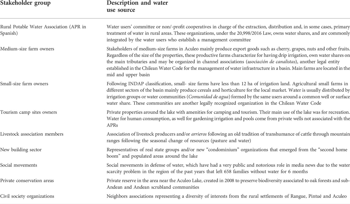
TABLE 1. Groups of stakeholder groups interviewed in the Aculeo Lake basin.
A causal loop diagram (CLD) is a conceptual approach used to illustrate the information found that led to some economic sectors being more adapted to the water scarcity and further influencing land use changes and water scarcity in the Aculeo basin. CLD is a common analysis tool in systems thinking that helps visualize causality, or how variables are interconnected and affect each other negatively or positively. Variables are connected by arrows with plus or minus signs showing the increase or decrease in the impacted variable due to the previous one. CLD has been used by Butler et al. (2014) to better understand what triggers could drive different adaptations and maladaptations in Indonesia’s Eastern Islands. In this study, variables affecting different economic sectors were classified by their scale of origin as direct driver (causes originated locally) and indirect driver (regional and national scale processes not controlled by local stakeholders, or systemic causes). Other intermediate variables are then connected showing causality between different phenomena.
Results
Land transformation in the Aculeo Lake basin
Using the methods presented in Land transformation in the Aculeo Lake basin, it was possible to define farmer typology by identifying surface area of agricultural plots and owner’s assets. Final patterns of changes in farm sizes experienced in the Aculeo Lake catchment within the 2006 and 2018 period are presented in Figure 2, where it is possible to observe that while the number of small-scale farmers dropped, the medium-scale farmers increased their property ownership between 2006 (Figure 2C) and 2018 (Figure 2D). The disaggregated information of agricultural land uses presented in Table 2 and in Figure 3A indicates that the decrease for small-scale farmers’ agricultural surface occupied by fruit trees was of 59% for the 2006–2018 period, while in the same period medium-scale farmers’ area with fruit trees increased by 94%. Regarding annual crops, both the medium- and small-scale farmers reported roughly 53 and 39% decreases, respectively, in their cultivated areas during the 2006–2018 period, which was predominantly replaced by grassland/bare soil (yellow bar in Figure 2A) or sold and replaced by houses.
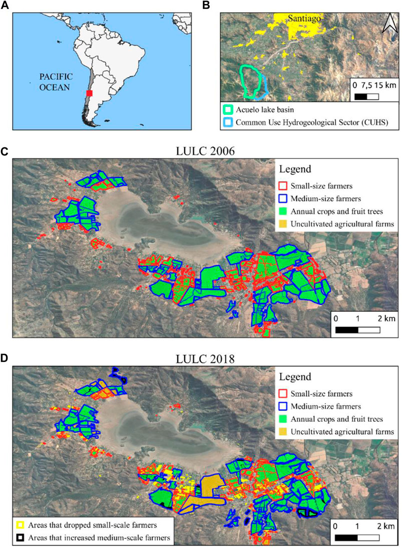
FIGURE 2. (A) Location of the study site in the Metropolitan Region, Central Chile, (B) location in respect with the Santiago de Chile city. (C) distribution of farm sizes in 2006 and (D) in 2018. The small-scale farmers are indicated using the red line, and the medium-scale farmers using the blue line. The productive farms are shown in green, and the uncultivated (grassland) farms are shown in yellow.
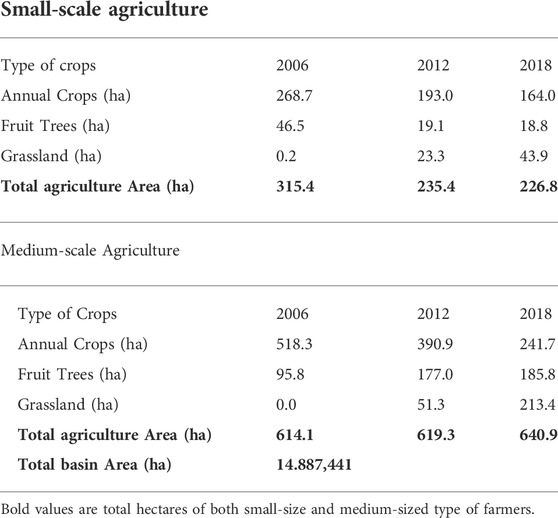
TABLE 2. Land uses of agricultural areas and their changes over time, classified by small- and medium-scale agriculture.
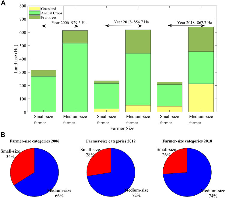
FIGURE 3. (A) Changes in agricultural land uses in Aculeo catchment between years 2006, 2012 and 2018, (B) changes in distribution of agricultural land uses in Aculeo Lake catchment between 2006, 2012 and 2018.
As can be observed in Table 2; Figure 3B, the medium-scale farmers as a group were not affected in terms of total agricultural surface, even experiencing an increase of about 4% during the 2012–2018 period, while the small-scale farmers decreased their total agricultural property by about 39% during the previous 2006–2012 period. As presented in Figure 3B, the small farmers went from owning 34% of the total agricultural property in the basin in 2006 to about 26% in 2018. However, when considering only cultivated areas, small farms decreased from about 34% of the total cultivated surfaces in the basin to about 30% within the 2006–2018 period. Furthermore, the observed trends indicate that despite the water scarcity in the basin, intensified by the megadrought, the medium-scale farmers increased the area of more economically valuable fruit trees in 2012 and maintained until 2018, while the small-scale farmers that adventured into fruit trees in 2006, reduced in 2012 and are now mostly holding to annual crops agriculture.
Water scarcity and land use change causal feedbacks
As we can now confirm with the LULC analysis that medium-size farmers were less affected by drought during the 2006–2018 period, the next step is to use the Causal Loop Analysis to better understand the reasons for those varying degrees of vulnerability to the same phenomenon. Besides climate variability and change causing the contextual drought, three indirect drivers found in the literature review and interviews with stakeholders (table 2) were identified as playing a key role in supporting the adaptive capacity of some actors while increasing the vulnerabilities of others:
a) Historical land and water property in Chile: As explained in section 1.1, during the Agrarian Reform expropriated land was distributed to peasants. Later, the Water Code of 1981 established water as a separate entity from real estate, and new water rights were granted by the National Water Directorate (DGA in Spanish). On top of the new water rights protected by the Water Code, the 1981 legislation acknowledged old water uses and rights, several of them granted along with land during the Agrarian reform, which today are managed by SAG. However, the DGA, which is in charge of the water rights registry and inspections to ensure proper water usage, does not have a registry of all the water rights that have been granted (including some water rights that are distributed after trials in court). Therefore, the volume of water being used in most Chilean basins is unclear (World Bank 2011), as is the case in the Aculeo basin (Barría et al., 2019). The problem with the water rights that were not granted and are not “perfected” (perfeccionados in spanish)4 by the DGA is the difficulty of overseeing its correct usage and fair distribution under drought conditions, which can generate conflicts among users. An additional indirect effect for users that do not have their water shares officially registered, is the barrier this produces to access government funds, a situation that is more common for small farmers (more on this below).
b) Economic incentives to export agriculture: Incentives provided for export agriculture after the Free Trade Agreement (FTA) between Chile and China and the Economic Partnership Agreement (EPA) between Chile and Japan has generated significant interest among farmers to produce cherries and other agricultural products under very specific requirements of quality and efficiency. These export requirements and the related permits cannot be achieved by all farmers, as it requires high investment in agricultural machinery, irrigation technology and human labor. Because of this, the Chilean Government has created different laws (e.g., Law for the Promotion of Irrigation and Drainage No. 18,450) and programs to support farmers with innovations and technology to supply the increasing demand; but again, access to these funds is bureaucratic and restricted in terms of compliance requirements. Therefore, only those farmers with a clear understanding of the system were able to apply and increase their ability to cope with drought.
c) Urban interest in rural life: As previously mentioned, the Aculeo basin is located near a large city, Santiago, where there has always been an urbanite interest in enjoying the amenities of rural life. According to studies, the uncontrolled urbanization of the Metropolitan Region of Santiago de Chile countryside has been promoted by land policies that have benefited urban advancement and the consumption of territory beyond its natural capacity (Barrado et al., 2020). Although we will not explore this complex issue here, it is being studied by other authors given its implications for equity, poverty and nature conservation (Berdegué and Proctor, 2014; Berdegué et al., 2015).
Although the short answer may be that some actors had access to more water and be more efficient in its use, in a closer analysis, three key direct drivers may have played a catalyst role in the transformation of this rural territory during the 2006–2018 period by increasing the adaptation possibilities of medium-size farmers compared with other more vulnerable water users in the basin:
a) Unequal access to funds: Although the Chilean government provided different incentives and support programs for small-scale and subsistence farmers to either modernize their irrigation infrastructure or improve market conditions (e.g., Law for the Promotion of Irrigation and Drainage No. 18,450), they did not take into consideration the inequalities that make funds and incentives programs less accessible for some small farmers that lack of ownership over the land and water shares (indirect driver a), as well as are less technologically prepared to access many funds that are promoted on government webpages. As presented by other authors, the adaptability of larger agricultural properties in Chile is not only due to more financial resources that allow them to physically reach other water sources, but also to their superior technical and financial ability to comply with the legal requirements to access more government financial aid (Budds, 2008). Those initial vulnerabilities (e.g., land property) later affected their capacity to cope with drought by becoming a barrier to access legal, financial, and technical resources that could support them to continue their economic activity. This is the reason why small-scale agriculture is not shown to be directly impacted by a decrease in rainfall (Figure 3), but rather by an increase in their water extraction costs (deeper aquifer level) that pushed most of them to abandon their land long before the lake’s disappearance.
b) Weak or non-existent rural planning: Aculeo basin is mostly a rural territory without communal urban planning (PRC in Spanish), as it is juridically dependent on Paine County and is under the regulations of the Metropolitan Region. According to the Metropolitan Region’s Development Plan, the Aculeo Lake region corresponds to an area of “Tourist-Landscape Interest” under the supervision of the Ministry of Agriculture, where construction of real estate projects for residential use and/or construction are allowed with a minimum of 7 ha and with 50% constructed area. The real estate project must prove feasibility of water access and sanitation by the local service provider or by another private group, as well as a guarantee of zero impact on the normal drinking water supply for the rest of the population. Urban planning regulations prohibit subdivision and construction in certain areas (e.g., above 600 m. a.s.l. in the mountain ranges; Pie de Monte Laguna de Aculeo Zone), but do not restrict urban expansion in the valley as long as water is not limited and the subdivision size is not smaller than the minimum5. However, demonstrating water supply problems can be challenging, not only due to a lack of aquifer data, but also because water distribution problems may not necessarily be related to lack of water, but to its management. In fact, APRs in Chile have been diagnosed with organizational, financial, and human inability to face common challenges, such as failures in infrastructure, climatic drought, incapacity to extend current infrastructure, among others (Amulen 2019). This is likely why APRs were the most affected during the summers of 2018 and 2019, as soon as the aquifer’s water table descended.
c) Weak or non-existent drought strategies/policies: The third direct driver identified is correlated with the delayed acceptance of a water crisis that prevented the prompt implementation of economic and legal policies that could have encouraged different vulnerable economic sectors and the society in general to adapt to minimal rainfall earlier. Again, those with more economic freedom rapidly implemented changes to face water scarcity (e.g., garden efficiency, deeper wells), leaving others feeling helpless and leading to increasing conflicts (Ocampo-Melgar et al., 2021). The result of this driver is the reinforcement of the water-land use feedback, which further transformed the economic base once water scarcity was evident. The tourism sector, for example, initially flourished with urbanization when water was abundant, but later crashed with the lake’s disappearance. However, those that were able to adapt and continue with their economic activity (including some medium-scale farmers) are today facing enormous difficulties (source: direct communication). Medium-scale farmers mentioned during their interviews that they will not be able to maintain their businesses much longer, as they have already implemented all the available water-efficient methods and technologies. Similarly, representatives of newer urbanizations mentioned that they needed information regarding what other measures can be taken to reduce water consumption, as it was clear that measures taken were insufficient.
The economic and social transformations revealed in the spatial analysis of land use conversion over the 2006–2018 period, as well as in the literature review and information gathered during interviews with key stakeholders, are shown in Figure 4 as climate and anthropogenic pressures that not only affected water resources, but also land uses that lead to further water demands (e.g. for gardens and pools). The causal loop analysis shows how different land users were requiring water resources, but with different degrees of initial vulnerabilities. These differing vulnerabilities are the result of indirect, historical, and/or systemic drivers, as well as more direct drivers that can be locally controlled. As a result, some land use changes such as urbanization may further exacerbate the drought by putting more pressure on groundwater extraction (as was explored in Barría et al., 2021c).
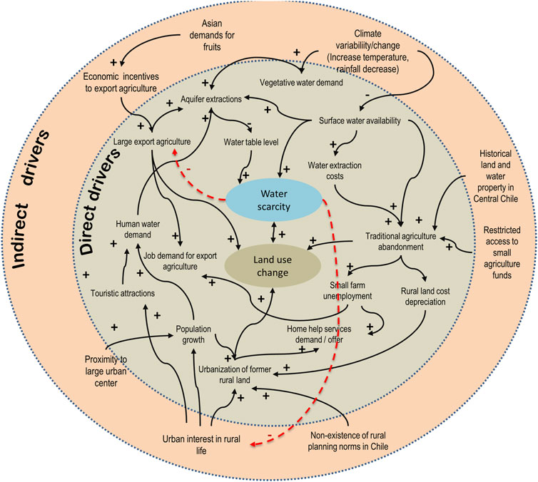
FIGURE 4. Causal loop diagram showing the main influences of internal and indirect external drivers of change, as well as the increasing or decreasing influence on the most important water and land users in the basin (inspired by Butler et al., 2014)6.
Discussion
Despite the private ownership of water and the ruling market system, this historical analysis shows this was a common-pool resource problems’ dilemma that required a deeper analysis to establish and enforce collective action and rules which considered resource scarcity, unequal access to resource and governance failures, among other aspects (Ostrom, 2005). The LULC analysis of this social-ecological system shows that some economic sectors persisted during the water scarcity (e.g., export farming). However, it also demonstrates that this observed “adaptability” in the context of a drought is significantly impacted by past and present policies that have exacerbated the inequalities between different stakeholders’ vulnerabilities, and that adaptation is not necessarily sustainable for all involved actors nor the ecosystem (i.e. aquifer water reserves and Aculeo lake). This is an important finding for future climate and water management policies, as more synergy between development and economic policies is necessary to avoid negative feedbacks that result in maladaptation increasing impacts. As other authors have mentioned before, different economic sectors will experience water scarcity unequally (Swyngedouw, 2009; Fragkou, 2019), likely the consequence of a history of inequalities intensifying vulnerabilities and undermining social-ecological resilience (Folke et al., 2002). Ultimately, assessing the sustainability of an adaptive path is value-laden, subjective and political (Folke, 2016).
Historical land and water appropriation in Chile has also created complex circumstances in rural territories, a situation that is not always considered when implementing standard economic or development policies that will not reach the more in need. Incentives and subsidies that prioritize an increase in crop yield will always lead to farmland transformation (Comito et al., 2013). In the case of the Aculeo Lake region, the utilization of incentives for export agriculture not only altered the land and water consumption from both the lake and the aquifer, precisely in the beginning of a megadrought, but also resulted in additional advantages for those with more historical assets and resilience (that were able to implement irrigation technology), over the already precarious legal and economic situation of many small-scale farmers that were limited in accessing water sources.
The failure to acknowledge the fragile hydroclimatic situation in this territory in combination with these incentives may have supported a type of economy that was not only unsuitable for the environmental conditions, but also aggravated the consequences of the drought for those already vulnerable. Similarly, as there were no incentives for sustainable use of land and water nor preservation of tradition (e.g., Fischer et al., 2012), the combination of other factors such as urbanites’ aspiration to own a rural second home along with the insubstantial rules regarding planning and development in Chile’s rural territories, result in the purchase of rural lands by actors with greater economic capacity, and the potential displacement of the rural population (Riveros, 2015).
Finally, the analysis of internal and external drivers shows that the observed endurance in a group of actors is not dependent only on “adaptive capacity”, nor has necessarily lead to sustainability for the community as a whole. In the long run, a combination of unequal access to funds to improve technology and unsustainable policies that pushed for competition, shaped the economic use of this territory, intensifying inequalities and vulnerabilities, while negatively impacting the sustainability of water resources. Studies of coastal communities have shown that efforts to build adaptive capacity to climate change need to consider power inequalities and political factors that may impair the potential impacts of intervention, otherwise these efforts can exacerbate vulnerabilities while threatening the long-term sustainability of coastal ecosystems (Cinner et al., 2018). Same considerations must be implemented when addressing development and poverty alleviation in rural territories worldwide, as these are not only the base for food security, but also guardians of traditions and important ecosystems which we depend.
Conclusion
The Aculeo Lake case represents a critical example of what adaptation could potentially look like in rural Chile and probably in many rural regions worldwide if we do not consider all drivers of change and their different impacts on societies’ capability to adjust their structure and institutions to impacts of climate change on water resources (Petersen-Perlman et al., 2012). The Aculeo basin case analysis shows that major changes due to direct and indirect social and economic drivers may have influenced climate vulnerability of certain economic sectors (e.g. small-size farmers that had historical and legal disadvantages to access funds), long before the impacts of climatic drought-induced water scarcity. Despite the rather insignificant decrease in total agricultural land use in the Aculeo Lake catchment within the study period (62 ha or 6.7%), the unequal financial capacity and access to water allowed medium-scale farmers to keep their uncultivated properties and focus on producing the most profitable crops (fruit trees), while small-scale farmers either sold their properties or focused on subsistence and less profitable annual crops (cereals and vegetables). Rapid urbanization and agri-business growth were not as noticeable when water was abundant, until the 10-years rainfall deficit in combination with constant water demand made a 12 km2 lake disappear, at which point agricultural producers’ disproportionate adaptive capacities to climate change and variability became evident and a source of conflict (Ocampo-Melgar et al., 2021).
This study concludes that development policies and historical vulnerabilities created the proper scenario for a rapid economic and cultural change to significantly impact the less resilient or prepared, while further aggravating the water scarcity crisis. The ability of some agricultural producers to recover from shocks and respond to changes in institutional systems may have sustained the economy and productivity of the region; but have not necessarily led to sustainability as water and land are still under stress. A more thorough analysis of the impacts of direct and indirect drivers of change in rural territories in Central Chile, as well as a better understanding of who is most affected by climate change impacts and policies, could improve the development of sustainable policies and land uses as they relate to the ongoing climate crisis.
Data availability statement
The datasets presented in this study can be found in online repositories. The names of the repository/repositories and accession number(s) can be found below: Data are GIS layers.
Author contributions
AOM: Conceptualization, Data curation, Formal analysis, Methodology, Writing—original draft. PB: Funding acquisition, Project administration, Formal analysis, Writing and review and editing. CC: Climate analysis, Writing—review and editing. RD-V: Formal analysis (LULC analysis).
Conflict of interest
The authors declare that the research was conducted in the absence of any commercial or financial relationships that could be construed as a potential conflict of interest.
Publisher’s note
All claims expressed in this article are solely those of the authors and do not necessarily represent those of their affiliated organizations, or those of the publisher, the editors and the reviewers. Any product that may be evaluated in this article, or claim that may be made by its manufacturer, is not guaranteed or endorsed by the publisher.
Footnotes
1https://chile.gob.cl/china/asuntos-comerciales/oficina-comercial/tratado-de-libre-comercio-chile-china
2https://www.odepa.gob.cl/wp-content/uploads/2015/08/Cerezas2015.pdf
3https://www.economist.com/the-americas/2019/01/19/a-cheery-tale-of-chilean-cherries
4The “perfection process” was established in article 44 of the Supreme Decree 1220 and corresponds to the clarification of the characteristics of a water right essential to allow its register in the CPA. These characteristics include volume by unit of time, coordinates of the place of extraction, among others.
5In rural areas it is possible to urbanize rural properties with a minimum size previously established by Chilean Law No. 3,516 of 1980, in which Article 1 defines the minimum size of a rural urbanized property as 0.5 ha. This size was modified by the ordinance of the Santiago Metropolitan Regulatory Plan approved in October 2007, which defines the minimum property size for Aculeo below 400 m.a.s.l. as 1.5 ha and between 400 and 600 m.a.s.l. as 2 ha. However, the approval time of the ordinance was enough that it allowed the entry of many rural properties before the new ordinance further restricted the minimum size (even if they were not built at the time).
6Other problems related with natural vegetation, protected areas and vulnerability to fire risk and non-native flora and fauna invasion are not discussed here; but will play a role in future land use change.
References
AghaKouchak, A., Feldman, D., Hoerling, M., Huxman, T., and Lund, J. (2015). Water and climate: Recognize anthropogenic drought. Nature 524 (7566), 409–411. doi:10.1038/524409a
Alizade Govarchin Ghale, Y., Altunkaynak, A., and Unal, A. (2018). Investigation anthropogenic impacts and climate factors on drying up of Urmia Lake using water budget and drought analysis. Water Resour. Manag. 32, 325–337. doi:10.1007/s11269-017-1812-5
Altieri, M., and Nicholls, C. (2008). Los impactos del cambio climático sobre las comunidades campesinas y agricultores tradicionales y sus repuestas adaptativas. Agroecología 3, 7
Arkian, F., Nicholson, S. E., and Ziaie, B. (2018). Meteorological factors affecting the sudden decline in Lake Urmia’s water level. Theor. Appl. Climatol. 131 (1-2), 641–651. doi:10.1007/s00704-016-1992-6
Barría, P., Chadwick, C., Ocampo-Melgar, A., Díaz-Vasconcellos, R., Galleguillos, M., et al. (2021a). Estudio de Balance Hídrico en la Cuenca Laguna de Aculeo. prendizajes para la gestión de recursos hídricos frente a la escasez hídrica. Santiago, Chile. ISBN 978-956-402-790-6.
Barría, P., Barría Sandoval, I., Guzman, C., Chadwick, C., Alvarez-Garreton, C., Díaz-Vasconcellos, R., et al. (2021b). Water allocation under climate change: A diagnosis of the Chilean system. Elementa: Science of the Anthropocene 9 (1). doi:10.1525/elementa.2020.00131
Barrado, V. J., Suckel, J. L., Olhabé, B. T., and Cona, F. C. (2020). Promoted urbanization of the countryside: The case of santiago’s periphery, Chile (1980–2017). Land 9, 370–420. doi:10.3390/land9100370
Barría, P., Rojas, M., Moraga, P., Munoz, A., Bozkurt, D., and Alvarez-Garreton, C. (2019). Anthropocene and streamflow: Long-term perspective of streamflow variability and water rights. Elem. Sci. Anth 7, 2. doi:10.1525/elementa.340
Barría, P., Sandoval, I. B., Guzman, C., Chadwick, C., Fuster, R., Melgar, A. O., et al. (2021c). Water allocation under climate change: A diagnosis of the Chilean system. Elem. Sci. Anth 9, 1. doi:10.1525/elementa.2020.00131
Bauer, C. (1998). Against the current: privatization, water markets, and the State in Chile. New York, NY: Springer Science New York.
Bauer, C. J. (2004). Siren song: Chilean water law as a model for international reform. Washington: Resources for the Future. doi:10.4324/9781936331062
Bauer, C. (2015). Water conflicts and entrenched gover nance problems in Chile’s market model. Water Altern. 8 (2), 147–172.
Bellisario, A. (2007). The Chilean agrarian transformation: Agrarian reform and capitalist “partial” counter-agrarian reform, 1964-1980. Part 1: Reformism, socialism and free-market neoliberalism. J. Agrar. Change 7, 1–34. doi:10.1111/j.1471-0366.2007.00138.x
Berdegué, J. A., Carriazo, F., Jara, B., Modrego, F., and Soloaga, I. (2015). Cities, territories, and inclusive growth: Unraveling urban-rural linkages in Chile, Colombia, and Mexico. World Dev. 73, 56–71. doi:10.1016/j.worlddev.2014.12.013
Berdegué, J., and Proctor, F. (2014). Cities in the rural transformation. Work. Pap. Ser. Work. Gr. Dev. with Territ. Cohes., 1–7. Available at: www.rimisp.org/wp.../files.../1421411411Citiesintheruraltransformation_edited.pdf.
Budds, J. (2009). Contested H2O: Science, policy and politics in water resources management in Chile. Geoforum 40, 418–430. doi:10.1016/j.geoforum.2008.12.008
Budds, J. (2008). “Whose scarcity? The hydrosocial cycle and the changing waterscape of La ligua river basin, Chile,” in Contentious geogr. Environ. Knowledge, mean. Scale (Farnham, United Kingdom: Ashgate), 59.
Butler, J. R. A., Suadnya, W., Puspadi, K., Sutaryono, Y., Wise, R. M., Skewes, T. D., et al. (2014). Framing the application of adaptation pathways for rural livelihoods and global change in eastern Indonesian islands. Glob. Environ. Chang. 28, 368–382. doi:10.1016/j.gloenvcha.2013.12.004
Carrasco, L. T. (2017). Cambio generacional y radicalización campesina Evolución del proceso de Reforma Agraria en Paine (1967-1973). Political Sci. 16, 43–57. doi:10.4067/s0718-65682017000200043
CED (Centro de Estudios para el Desarrollo) (2008). Plan de Gestión Ambiental para la Cuenca de Aculeo, Región Metropolitana de Santiago. Proyecto CONAMA / GEF-PNUD “Conservación de la Biodiversidad en los Altos de Cantillana, Chile”. Available at: http://transparencia.paine.cl/Descargas_Trans/Planes_Comuna_Paine/Plan_Gestion_Ambiental/Informe_Final_Aculeo_04-07-2008.pdf
Cinner, J. E., Adger, W. N., Allison, E. H., Barnes, M. L., Brown, K., Cohen, P. J., et al. (2018). Building adaptive capacity to climate change in tropical coastal communities. Nat. Clim. Chang. 8, 117–123. doi:10.1038/s41558-017-0065-x
Comito, J., Wolseth, J., and Morton, L. (2013). The state’s role in water quality: Soil and water conservation district commissioners and the agricultural status quo. Hum. Organ. 72, 44–54. doi:10.17730/humo.72.1.e5h845348306411h
Coppens, J., Trolle, D., Jeppesen, E., and Beklioğlu, M. (2020). The impact of climate change on a mediterranean shallow lake: Insights based on catchment and lake modelling. Reg. Environ. Change 20, 62. doi:10.1007/s10113-020-01641-6
De la Fuente, A., and Meruane, C. (2017). Spectral model for long-term computation of thermodynamics and potential evaporation in shallow wetlands. Water Resour. Res. 53, 7696–7715. doi:10.1002/2017WR020515
Delgado, L. E., Torres-Gómez, M., Tironi-Silva, A., and Marín, V. H. (2015). Estrategia de adaptación local al cambio climático para el acceso equitativo al agua en zonas rurales de Chile. Am. Lat. Hoy Rev. Cienc. Soc. 69, 113–137. doi:10.14201/alh201569113137
Ericksen, P., Bohler, H. G., and Stewart, B. (2010). “Vulnerability and resilience of food systems,” in Food security and global environmental change. Editors J. Ingram, P. Ericksen, and D. Liverman (London- Washington, DC: earthscan), 67.
Eriksen, S. H., Nightingale, A. J., and Eakin, H. (2015). Reframing adaptation: The political nature of climate change adaptation. Glob. Environ. Change 35, 523–533. doi:10.1016/j.gloenvcha.2015.09.014
EULA (2004). Establecimiento de un ordenamiento territorial orientado a la protección y uso sustentable del área del cordón de Cantillana. Available at: http://www.sinia.cl/1292/articles-37027_eula.pdf
Fathian, F., Morid, S., and Kahya, E. (2015). Identification of trends in hydrological and climatic variables in Urmia Lake basin, Iran. Theor. Appl. Climatol. 119 (3-4), 443–464. doi:10.1007/s00704-014-1120-4
Fischer, J., Hartel, T., and Kuemmerle, T. (2012). Conservation policy in traditional farming landscapes. Conserv. Lett. 5, 167–175. doi:10.1111/j.1755-263X.2012.00227.x
Folke, C., Carpenter, S., Elmqvist, T., Gunderson, L., Holling, C. S., and Walker, B. (2002). Resilience and sustainable development: Building adaptive capacity in a world of transformations. AMBIO A J. Hum. Environ. 31 (5), 437–440. Stockholm. doi:10.1579/0044-7447-31.5.437
Fragkou, J., Hohl, J., and Fragkou, M. (2019). Escasez de agua : Develando sus orígenes híbridos en la cuenca del río bueno , Chile. Rev. Geogr. Norte Gd. 73, 9–27. doi:10.4067/s0718-34022019000200009
Fraser, E. D. G., Dougill, A. J., Hubacek, K., Quinn, C. H., Sendzimir, J., and Termansen, M. (2011). Assessing vulnerability to climate change in dryland livelihood systems: Conceptual challenges and interdisciplinary solutions. Ecol. Soc. 16, 3. doi:10.5751/ES-03402-160303
Garreaud, R. D., Alvarez-Garreton, C., Barichivich, J., Pablo Boisier, J., Christie, D., Galleguillos, M., et al. (2017). The 2010-2015 megadrought in central Chile: Impacts on regional hydroclimate and vegetation. Hydrol. Earth Syst. Sci. 21, 6307–6327. doi:10.5194/hess-21-6307-2017
Garreaud, R. D., Boisier, J. P., Rondanelli, R., Montecinos, A., Sepúlveda, H. H., and Veloso-Aguila, D. (2019). The Central Chile mega drought (2010–2018): A climate dynamics perspective. Int. J. Climatol. 40, 421–439. doi:10.1002/joc.6219
Gitz, V., Meybeck, A., Lipper, L., Young, C., and Braatz, S. (2016). Climate change and food security: Risks and responses. Rome, Italy: FAO.
Hearne, R., and Donoso, G. (2014). Water markets in Chile: Are they meeting needs?” in Water markets for the 21st century, Editors K. W. Easter, and Q. Huang (Berlin, Germany: Springer) 103.
Liverman, D., and Ericksen, P. (2009). Governing food systems in the context of global environ- mental change. IHDP (3), 59–64.
Madaleno, I. M., and Gurovich, A. (2007). Usos conflictivos del agua en el Norte de Chile. Bol. La Asoc. Geogr. Esp. (45), 353–372.
Magnan, A. K., Schipper, E. L. F., Burkett, M., Bharwani, S., Burton, I., Eriksen, S., et al. (2016). Addressing the risk of maladaptation to climate change. WIREs Clim. Change 7, 646–665. doi:10.1002/wcc.409
Massey, E., Huitema, D., Garrelts, H., Grecksch, K., Mees, H., Rayner, T., et al. (2015). Handling adaptation policy choices in Sweden, Germany, the UK and The Netherlands. J. Water Clim. Chang. 6, 9–24. doi:10.2166/wcc.2014.110
Milly, P. C. D., Betancourt, J., Falkenmark, M., Hirsch, R. M., Zbigniew, W., Lettenmaier, D. P., et al. (2008). Stationarity is dead: Whither water management. Science 319, 573–574. doi:10.1126/science.1151915
Milly, P. C. D., Betancourt, J., Falkenmark, M., Hirsch, R. M., Zbigniew, W., Lettenmaier, D. P., et al. (2015). On critiques of “stationarity is dead: whither water management?”. Water Resour. Res. 51, 7785–7789. doi:10.1002/2015WR017408
Morton, J. F. (2007). Climate Change and Food Security Special Feature: The impact of climate change on smallholder and subsistence agriculture. Proc. Natl. Acad. Sci. U. S. A. 104, 19680–19685. doi:10.1073/pnas.0701855104
Ocampo-Melgar, A., Barria, P., Chadwick, C., and Villoch, P. (2021). Restoration perceptions and collaboration challenges under severe water scarcity: The Aculeo lake process. Restor. Ecol. 29, 1–12. doi:10.1111/rec.13337
Órdenes, M., and Díaz-Diego, J. (2018). Cuando la mano de obra se subleva: estrategias terratenientes durante la reforma agraria chilena (1964-1973). Historia agraria. Revista de agricultura e historia rural 74, 201–230. doi:10.26882/histagrar/074e07o
ODEPA (2000). Clasificación de las explotaciones agrícolas del VI Censo Nacional Agropecuario, según tipo de productor y localización geográfica. Available at: https://www.odepa.gob.cl/wp-content/uploads/2019/04/explotaciones.pdf
Pahl-Wostl, C. (2006). Transitions towards adaptive management of water facing climate and global change. Water Resour. manage. 21, 49–62. doi:10.1007/s11269-006-9040-4
Perch, L. (2011). Mitigation of what and by what ? adaptation by whom and for whom ? dilemmas in delivering for the poor and the vulnerable in the international climate policy. Int. Policy Centre Incl. Growth 54.
Perreault, T. (2020). Climate change and climate politics: Parsing the causes and effects of the drying of Lake Poopó, Bolivia. J. Lat. Am. Geogr. 19 (3), 26–46.
Petersen-Perlman, J. D., Veilleux, J. C., Zentner, M., and Wolf, A. T. (2012). Case studies on water security: Analysis of system complexity and the role of Institutions. J. Contemp. Water Res. Educ., 4–12.
Prieto, M. (2017). El Riego que el Mercado no Quiere Ver: Historia del Despojo Hídrico en las Comunidades de Lasana y Chiu-Chiu (Desierto de Atacama, Chile). J. Lat. Am. Geogr. 16 (2), 69–91. doi:10.1353/lag.2017.0022
Prieto, M., Fragkou, C., and Calderón, M. (2019). “Water policy and management in Chile,” in Encyclopedia of water: Science, technology, and society. Editor P. Maurice (New Jersey, United States: John Wiley & Sons). doi:10.1002/9781119300762.wsts0055
Riveros, C. V. (2015). Respuesta municipal ante escasez de agua potable: Una mirada desde la Ecología Política. Municipal response to drinking water shortage: A look from Political Ecology. Master thesis in Human Settlements and Environment. Santiago (Chile): Pontifical Catholic University of Chile.
Siders, A. R. (2019). Adaptive capacity to climate change: A synthesis of concepts, methods, and findings in a fragmented field. WIREs Clim. Change 10, 1–18. doi:10.1002/wcc.573
Smit, B., and Wandel, J. (2006). Adaptation, adaptive capacity and vulnerability. Glob. Environ. Change 16, 282–292. doi:10.1016/j.gloenvcha.2006.03.008
Swyngedouw, E. (2009). The political economy and political ecology of the hydro-social cycle. J. Contemp. Water Res. Educ. 142, 56–60. doi:10.1111/j.1936-704x.2009.00054.x
Trimble, M., Jacobi, P. R., Olivier, T., Pascual, M. A., Zurbriggen, C., Garrido, L., et al. (2021). “Reconfiguring water governance for resilient social-ecological systems in South America,” in Water resilience: Management and governance in times of change. Editors J. Baird,, and R. Plummer (Cham, Switzerland: Springer International Publishing), 113.
Turner, B. L., Kasperson, R. E., Matson, P. a., McCarthy, J. J., Corell, R. W., Christensen, L., et al. (2003). A framework for vulnerability analysis in sustainability science. Proc. Natl. Acad. Sci. U. S. A. 100, 8074–8079. doi:10.1073/pnas.1231335100
Warner, B. P., Walsh-Dilley, M., Nelson-Nuñez, J., and Duvall, C. S. (2020). Rural Transformation in Latin America’s Changing Climate. J. Lat. Am. Geogr. 19, 10–25.
World Bank (2013). Estudio para el mejoramiento del marco institucional para la gestión del agua. Available at: https://documents.worldbank.org/en/publication/documents-reports/documentdetail/452181468216298391/chile-diagn-243-stico-de-la-gesti-243-n-de-los-recursos-h-237-dricos?qterm_test1=Estudio+para+el+mejoramiento+del+marco+institucional+para+la+gesti%C3%B3n+del+agua
Keywords: vulnerabilities, climate adaptation, rurality, water use, drought, adaptive capacity, sustainability
Citation: Ocampo-Melgar A, Barria P, Chadwick C and Diaz-Vasconcellos R (2022) Rural transformation and differential vulnerability: Exploring adaptation strategies to water scarcity in the Aculeo Lake basin (Chile). Front. Environ. Sci. 10:955023. doi: 10.3389/fenvs.2022.955023
Received: 27 May 2022; Accepted: 12 September 2022;
Published: 30 September 2022.
Edited by:
Amineh Ghorbani, Delft University of Technology, NetherlandsReviewed by:
José A. Zabala, Universidad Politécnica de Cartagena, SpainVeeshan Rayamajhee, North Dakota State University, United States
Copyright © 2022 Ocampo-Melgar, Barria, Chadwick and Diaz-Vasconcellos. This is an open-access article distributed under the terms of the Creative Commons Attribution License (CC BY). The use, distribution or reproduction in other forums is permitted, provided the original author(s) and the copyright owner(s) are credited and that the original publication in this journal is cited, in accordance with accepted academic practice. No use, distribution or reproduction is permitted which does not comply with these terms.
*Correspondence: Anahi Ocampo-Melgar, anahi.ocampo10@gmail.com