Optimization and classification control of permanent basic farmland based on quality classification
 Wei Wang1
  Liangyou Wen
- 1Geographic Information Engineering Brigade, Jiangxi Provincial Geological Bureau, Nanchang, China
- 2Jiangxi Provincial Institute of Land and Space Survey and Planning, Nanchang, China
- 3College of Land Sciences and Technology, China Agricultural University, Beijing, China
- 4Nanchang Qingyun Pu School, Nanchang, China
Permanent basic farmland plays an important role in stabilizing agricultural production and ensuring national food security. Therefore, it is necessary to reasonably delineate and control permanent basic farmland. This article is based on the idea of classifying the quality of cultivated land resources, combined with the rules for the delineation of permanent basic farmland, and from the perspective of the synergy of “suitability-connectivity-stability” of cultivated land, a indicator system is constructed. Application of suitability, connectivity, and stability evaluation methods. Taking Zhangshu City, Jiangxi Province as an example, the status of cultivated land resources is comprehensively evaluated, and permanent basic farmland is optimized and graded for protection. The results show that: (1) the arable land in Zhangshu City is mainly of medium suitability, medium continuity and high stability. (2) Zhangshu City is divided into 43218.80 hm2 of permanent basic farmland, accounting for 79.35% of the total area of cultivated land. (3) Control and partition permanent basic farmland into three categories: core protected areas for permanent basic farmland, quality improvement areas, and key transformation areas. The above results indicate that this evaluation has a supportive role in supporting the spatial optimization and hierarchical management of permanent basic farmland, and is of great significance for the unified management of natural resources.
1 Introduction
Farmland is the land resource has become a global and strategic issue affecting economic and social development. The continuous reduction of farmland area has limited the potential for further grain production, which seriously threatens global food security (Chen et al., 2021). China has designated permanent basic farmland to reduce the reduction of arable land area. Permanent basic farmland, as the essence of arable land, plays a crucial role in ensuring national food security and the supply of essential agricultural products (Lambin et al., 2013; Chen et al., 2021; Wu et al., 2022). The scientific and rational delineation of permanent basic farmland is of significant strategic importance in protecting arable land, stabilizing agricultural production, ensuring food and ecological security, and promoting socio-economic development in China (Xia et al., 2016; Wu et al., 2017a; Qianwen et al., 2017; Song et al., 2022). With the advancement of national spatial planning, the delineation of the ecological protection redline, permanent basic farmland, and urban development boundaries has been completed nationwide, resulting in the demarcation of 1.55 billion mu (15 mu = 1ha) of permanent basic farmland. However, during the process of delineating permanent basic farmland, considerations for local economic development have, to some extent, led to issues such as “distant delineation, poor optimization, and dispersed spatial layout” of permanent basic farmland (Liu et al., 2014; Ge et al., 2018). Furthermore, inadequate consideration of the ecological environment and variations in quality within permanent basic farmland have rendered the already delineated areas unable to fully meet the requirements of ecological protection and graded classification control (Peng et al., 2017; Qi et al., 2018; Liu et al., 2020). Consequently, the optimization and classification control of permanent basic farmland have become pressing concerns for researchers.
Currently, research on permanent basic farmland mainly focuses on the delineation system (Bernues et al., 2016; Liu et al., 2020), delineation methods (FAO, 1985; Steiner, 1987; Liu et al., 2010; Xu and Zhang, 2013; Nosrati and Collins, 2019), and layout optimization (Liang et al., 2015; Fan et al., 2020). In terms of the delineation system, scientists have developed various evaluation systems, including “land suitability conditions” (Liu et al., 2015; Vidal Legaz et al., 2017), “natural quality and utilization quality” (Qian et al., 2021), and “land natural quality-utilization quality-environmental quality” (Arrouays et al., 2009; Liu et al., 2010), to conduct suitability assessments and delineations of permanent basic farmland. For example, the evaluation of land resource production potential in the United States focuses on the suitability of cultivated land, with insufficient attention paid to connectivity and stability. The same goes for the United Nations of an international frameworkfor evaluating sustainable land management. Regarding delineation methods, the typical and mainly used methods include fuzzy association rules (Xue et al., 2010), logistic regression models (Wang et al., 2020), soil quality index methods (SQI) and minimum data sets (MDSs) (Fazel et al., 2014; Cheng et al., 2015; Cao and Song, 2022). Vogel et al. (2019) build upon existing approaches and propose a concept to evaluate individual soil functions with respect to the soil’s intrinsic potential in contrast to its actual state (Vogel et al., 2019). Guan et al. (2023) established a national spatial ecological importance evaluation system, systematically describing the morphological characteristics of farmland utilization in different ecological functional areas, and diagnosing the main problems in farmland utilization in different ecological functional areas (Guan et al., 2023). Therefore, scientific farmland evaluation provides a basis and guidance for basic farmland delineation and protection (Cheng et al., 2015). In the field of layout optimization, continuous efforts have been made to optimize permanent basic farmland based on national spatial planning, particularly during the delineation of the “Three Zones and Three Lines” (Zhao et al., 2019; Guo and Han, 2021; Lu and Li, 2022). These studies have significantly enriched the theories, methods, and optimization layouts of permanent basic farmland delineation, contributing substantially to the field. However, there is still a lack of a unified delineation system for permanent basic farmland, the utilization of arable land resource of “suitability-connectivity-stability” in the delineation process has not been explored, and there has been insufficient focus on the classification management of permanent basic farmland. This has, to a certain extent, resulted in the irrational delineation of permanent basic farmland, which hampers effective land resource management.
To address these points, we try to construct an indicator system based on the synergy of suitability, connectivity, and stability, explore the combination of the classification results of arable land resource quality and the delineation of permanent basic farmland, Optimize the method for delineating permanent basic farmland and classify and control permanent basic farmland (Figure 1). Using Zhangshu City in Jiangxi Province, located in the transitional zone between the rolling hills of central Jiangxi and the plains of Poyang Lake, specifically on the southern edge of the Poyang Lake plain, has both the characteristics of plains and mountainous hills, making it a typical southern terrain, and it is main grain producing area, as an example, the delineation approach for permanent basic farmland will be validated. The aim is to provide a scientific basis for the rational delineation, optimization of layout, and classification management of permanent basic farmland.
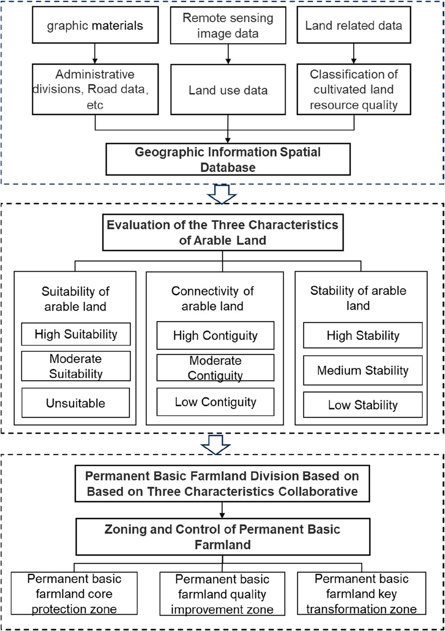
Figure 1. Roadmap for optimization of permanent basic farmland.
2 Materials and methods
2.1 Research area and data sources
2.1.1 Research area
Zhangshu City is located in the central part of Jiangxi Province (Figure 2), 76 km away from the provincial capital, Nanchang. It is situated between 27°49′07″to 28°09′15″N and 115°06′33″to 115°42′23″E. To the east, it borders Fengcheng; to the south, it adjoins Xingan; to the west, it is adjacent to Xinyu; and to the north, it connects with Gao’an. The city covers an area stretching 5,000 km from east to west and 31 km from north to south. Zhangshu City lies in the transitional zone between the rolling hills of central Jiangxi and the plains of Poyang Lake, specifically on the southern edge of the Poyang Lake plain. The terrain is relatively flat, with rivers crisscrossing the region. The central part features lower elevation, while the two sides are higher, sloping towards the center. The central area consists of alluvial plains formed by river valleys, which are expansive and low-lying, creating a north-south connection. The eastern and western flanks rise higher and slope towards the center. Zhangshu City has a subtropical monsoon climate, characterized by mild temperatures, distinct seasons, a relatively short frost period, and ample sunshine. The total land area of Zhangshu City is 1,27959 ha, and according to the 2021 land use change survey, the arable land area is 54,048.07 ha, accounting for 42.24% of the total land area. The predominant soil types in Zhangshu City include red soil, paddy soil, and sandy loam. Zhangshu City is a typical traditional agricultural production area in the middle and lower reaches of the Yangtze River plain, with rice production as its mainstay. In 2021, the total sown area for grains in Zhangshu City was 83,680 ha, with a total grain production of 521,899.98 tons, making it a major grain-producing region in Jiangxi Province.
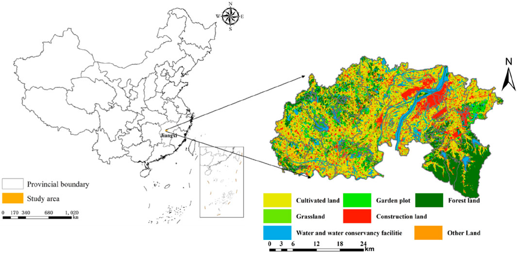
Figure 2. Location of the study area and land use.
2.1.2 Data sources
The data used in this study include administrative boundary data for Zhangshu City, soil organic matter content, soil depth, soil texture, soil pollution status, soil pH, slope, biodiversity, permanent basic farmland distribution, road data, and urban built-up area data, among others. The administrative boundary data, road data, and urban built-up area data for Zhangshu City were obtained from the 2021 Land Use Change Survey database. Data related to soil organic matter content, soil depth, soil texture, soil pollution status, soil pH, slope, biodiversity, and more were sourced from the 2020 arable Land Quality Classification database. Average plot area, plot density, plot shape index, and plot aggregation were calculated using plot data from the arable Land Quality Classification. Arable land stability data were generated using buffering analysis in ArcMap, analyzing the distance of plots to towns and roads, followed by classification and calculation. The data on permanent basic farmland distribution were derived from the results of the 2017 demarcation of permanent basic farmland in Zhangshu City (Table 1).
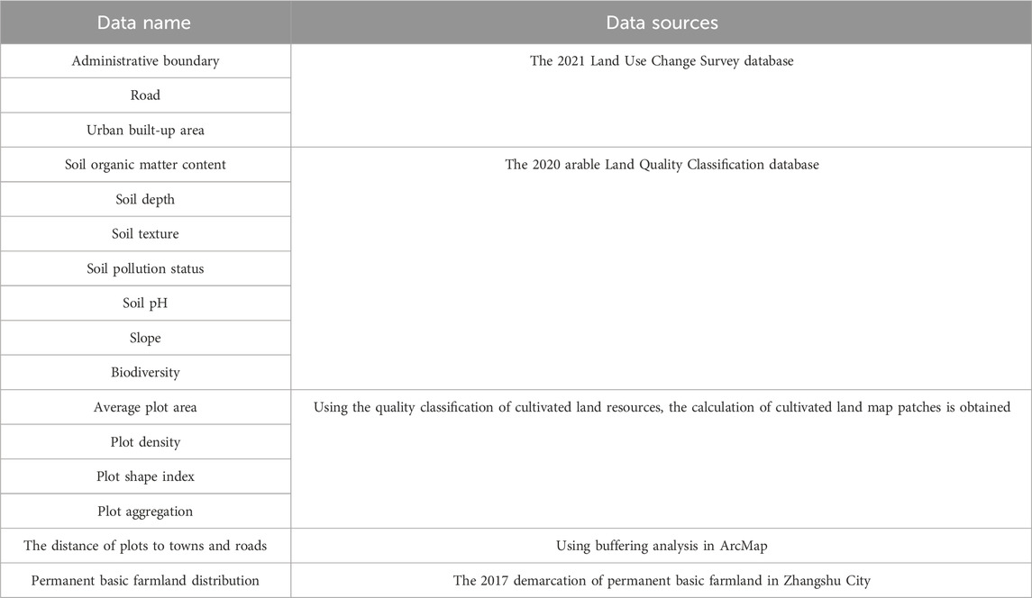
Table 1. Date suorces.
2.2 Research methodology
2.2.1 Classification of arable land resource suitability
This paper references the systematic approach of “Arable Land Resource Quality Classification” to evaluate the suitability level of arable land resources. It selects indicators such as slope, soil thickness, soil texture, soil organic matter content, soil pH value, soil heavy metal pollution status, and biodiversity for the classification of arable land resource suitability. The specific indicators and levels are detailed in Table 2.
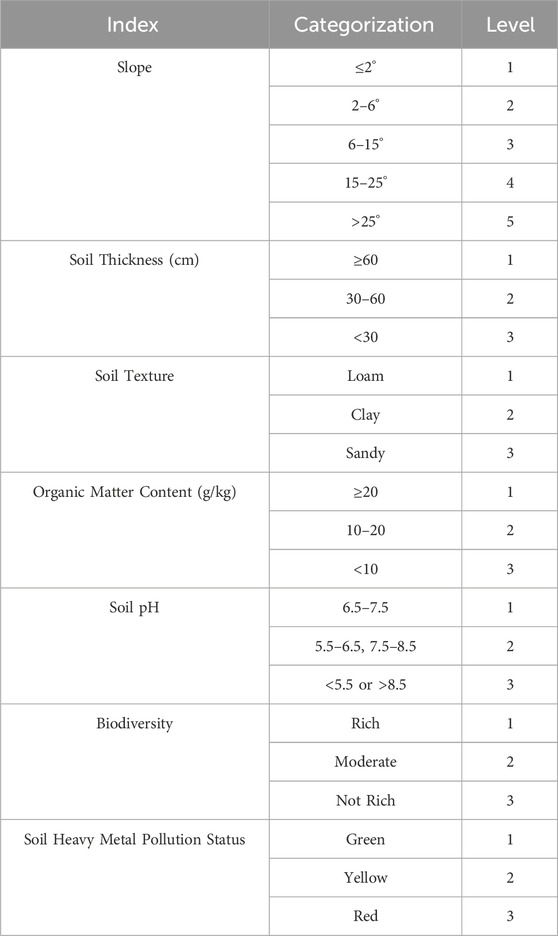
Table 2. Index system for evaluating the suitability of cultivated land.
Based on the categorization in Table 3, an evaluation of arable land suitability was conducted. As shown in Table 3, arable land suitability can be divided into 3,645 combination types. Considering the differences in the nature of suitability level indicators, they are classified into three categories: High Suitability, Moderate Suitability, and Unsuitability. The specific classification criteria are outlined in Table 3.
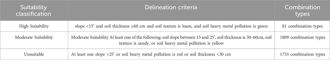
Table 3. Classification rules for cultivated land suitability.
2.2.2 Evaluation for arable land contiguity
Arable land contiguity refers to the degree of spatial connectedness and the presence of contiguous arable land parcels or groups of parcels within the same area with a certain scale (Xue et al., 2010). In this paper, arable land contiguity was comprehensively assessed from four aspects: average parcel size, patch density, patch shape index, and parcel clustering.
(1) Patch density
Patch density refers to the number of arable land patches per unit area. Generally, it is believed that a higher number of field patches within a certain area result in greater patch density, which is less conducive to improving farming efficiency. It can be calculated using the following formula:
Where LA represents the arable land area, and NP represents the number of arable land patches.
(2) Patch shape index
Patch are the fundamental units for irrigation, cultivation, and management. Therefore, the rationality of field design directly affects the effectiveness of irrigation, agricultural machinery use, and production management. It also impacts the effective arable land area. The patch shape index reflects the regularity of field shapes within a certain regional range. Patch shape can be categorized as regular or irregular, and the regularity of patch shapes directly affects the convenience of land use and management. It also determines the efficiency of land utilization. The formula for calculating the field shape index is as follows:
Where Pi represents the perimeter of field patch i, and LAi represents the area of field patch i.
(3) Arable land clustering
Parcel clustering characterizes the spatial clustering degree of arable land patches within a certain regional range. Higher arable land spatial clustering is more conducive to centralized farming and can improve farming efficiency. It can be calculated using the following formula:
Where LAi represents the area of field patch i, Pi represents the perimeter of arable land patch i.
The fragmentation of fields, field shape index, and arable land clustering will be categorized and encoded within the same level to assess arable land contiguity. Specific classification levels and codes can be found in Table 4.

Table 4. Evaluation index system for farmland connectivity.
According to the classification in Table 5, an assessment of arable land contiguity was conducted. As shown in Table 5, arable land contiguity can be divided into 27 combination types. Based on the nature of contiguity indicators, they are classified into three categories: High Contiguity, Moderate Contiguity, and Low Contiguity. The specific classification criteria can be found in Table 5.
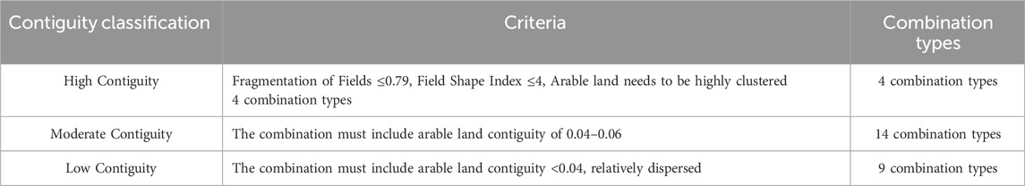
Table 5. Classification rules for farmland connectivity.
2.2.3 Arable land stability assessment
The stability of arable land resources refers to the ability of arable land to maintain its original characteristics over a certain period of time. This stability can be expressed through factors related to both internal stability and external pressures. The main factors causing instability in arable land are primarily socio-economic factors, specifically urban development pressures, and natural ecological factors, mainly including desertification and soil erosion as ecological constraints. Considering the correlation between natural ecological factors and the assessment results of arable land suitability for its impact on arable land stability, this study only considers the stability of arable land under the influence of socio-economic factors, particularly the impact of urbanization and infrastructure development on arable land stability. Specifically, three indicators were selected for detailed analysis, which are the distance from key towns, distance from roads, and distance from general towns. The specific grading of these indicators is shown in Table 6.
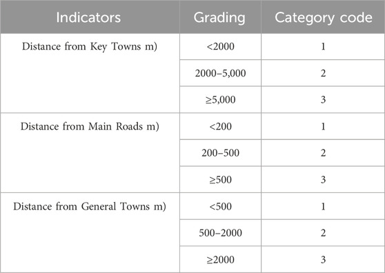
Table 6. Evaluation index system for farmland connectivity.
Based on the stability levels and following a quality classification approach, stability is categorized into three categories: high stability, medium stability, and low stability. The specific classification criteria can be found in Table 7.
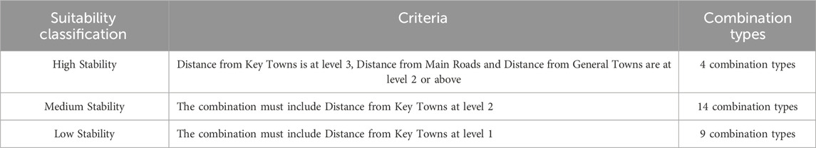
Table 7. Classification rules for cultivated land stability.
2.2.4 Classification of permanent basic farmland based on quality classification
Land classification involves merging land classification units based on different purposes and different attribute characteristics, ultimately categorizing land into different classes with distinct attributes (Lin et al., 2016; Zhang et al., 2020). In this study, we drew inspiration from the quality classification approach and constructed an index system for land resources classification based on the aspects of land suitability, contiguity, and stability. We assigned numerical values 1, 2, and 3 to represent different levels for each aspect and then arranged and combined these levels to create a total of 27 classes. The specific classification approach is outlined in Table 8. Land with suitability, contiguity, and stability levels all at or above level 2 is categorized as permanent basic farmland.

Table 8. Permanent basic farmland classification system based on suitability connectivity stability.
2.2.5 Delineation of graded protection zones for permanent basic farmland
According to the rules for delineating permanent basic farmland, based on the classification results of “suitability, contiguity, and stability,” 27 different results were divided into zones according to the criteria outlined in Table 9. The core protection zone for permanent basic farmland primarily considers high land suitability, good stability, good contiguity, and fewer limiting factors. It is defined as having at least two of the three categories (suitability, stability, and contiguity) at level 1. There are a total of four combinations meeting these criteria. The quality improvement zone for permanent basic farmland is defined as having at least one category that requires a longer time for improvement. Specifically, the criteria for this zone are that suitability and stability levels are not both at level 2, and the contiguity level is at least level 2. This is because suitability often requires a longer time for improvement, while stability is influenced by urban development and is not easily changed, relying on strict policy control. The key transformation zone for permanent basic farmland is defined by having a contiguity level of at least 2 and a stability level of 2 or above.
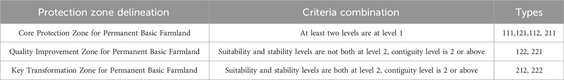
Table 9. Classification and protection rules for permanent basic farmland.
3 Research results
3.1 Evaluation results analysis of arable land suitability, continuity, and stability
As shown in Figure 3A, arable land suitability in Zhangshu City is mainly characterized by high suitability and moderate suitability. High suitability, moderate suitability, and unsuitability account for 17.23%, 82.48%, and 0.29% of the arable land area, respectively. Looking at different townships, the town with the most highly suitable arable land is Wucheng Township, with an area of 2,359.60 ha, followed by Yicheng Township, Zhongzhou Township, Huangtugang Township, Changfu Township, and Linjiang Township, with areas of 2,326.36, 897.14, 819.95, 770.48, and 707.25 ha, respectively. The townships with the least highly suitable arable land are Lujiang Street Office and Fucheng Street Office, both of which do not have highly suitable arable land. Ganxiang Street Office and Yongtai Township have relatively limited highly suitable arable land, with areas of only 0.25 and 2.84 ha, respectively. Townships with a relatively high distribution of moderately suitable arable land include Zhangjiashan Street Office, Linjiang Township, Jinglou Township, Liugongmiao Township, and Wucheng Township, all with areas exceeding 3,000 ha. Unsuitable arable land is mainly distributed in Zhangjiashan Street Office, Dianxia Township, and Geshan Township, with areas of 154.02, 2.13, and 0.04 ha, respectively. Other townships do not have unsuitable arable land. In terms of spatial distribution, highly suitable arable land is mainly concentrated in the southwestern region of Zhangshu City, while moderately suitable arable land is widely distributed throughout the city. Unsuitable arable land is mainly found in areas closer to the county seat, with the primary reason for unsuitability being heavy metal pollution in the arable land, indicated by the red color on the map.
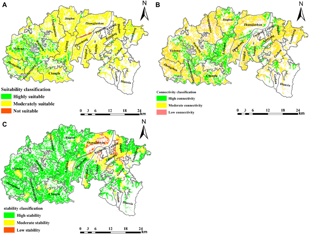
Figure 3. Evaluation results of arable land suitability, continuity, and stability in Zhangshu City.
As shown in Figure 3B, the continuity of arable land in Zhangshu City is primarily characterized by high continuity and moderate continuity, with high continuity, moderate continuity, and low continuity arable land areas accounting for 23.76%, 58.48%, and 17.76%, respectively. When looking at different townships, the town with the most highly continuous arable land is Wucheng Township, with an area of 2,359.60 ha. This is followed by Linjiang Township, Wucheng Township, Jinglou Township, Changfu Township, and Yicheng Township, with areas of 3,025.62, 1,800.03, 1,314.06, 1,256.05, and 1,151.39 ha, respectively. Geshan Township, Ganxiang Street Office, and Guanshang Township do not have highly continuous arable land. Moderately continuous arable land is more widely distributed in townships such as Wucheng Township, Zhangjiashan Street Office, Liugongmiao Township, Yicheng Township, and Guanshang Township, with areas of 3,000.56, 2,880.41, 2,795.76, 2,612.65, and 2,225.58 ha, respectively. The proportion of moderately continuous arable land in other townships is also relatively large. Low continuous arable land is mainly found in Liugongmiao Township, Wucheng Township, and Zhangjiashan Street Office, with areas of 1,065.00, 891.50, and 843.43 ha, respectively. Other townships have relatively fewer areas of low suitability arable land. In terms of spatial distribution, highly continuous arable land is primarily concentrated in the central and southwestern regions of Zhangshu City, with smaller amounts in the eastern and northern regions. Moderately continuous arable land is widely distributed throughout the city, with the highest concentration in the northwest and eastern regions. Low continuous arable land is sporadically distributed throughout the city, mainly in the peripheral areas of each township.
As depicted in Figure 3C, arable land stability in Zhangshu City is primarily characterized by high stability, with high stability arable land accounting for 80.75% of the total arable land area. Moderate stability arable land and low stability arable land have relatively smaller areas, totaling 8,586.83 ha and 1,897.88 ha, respectively. Their respective proportions are 15.76% and 3.48%.When examining the townships individually, the townships with larger areas of high stability arable land are Wucheng Township, Linjiang Township, Yicheng Township, Jinglou Township, and Liugongmiao Township, with areas of 5,678.22, 4,408.33, 4,164.37, 3,850.57, and 3,577.02 ha, respectively. Except for Lujiang Street Office and Fucheng Street Office, all other townships also have substantial areas of high stability arable land. Moderate stability arable land is most prevalent in Diao Street Office, with an area of 1,401.77 ha, followed by Zhangjiashan Street Office, Geshan Township, and Yanghu Township, with areas of 1,378.84, 1,052.00, and 907.42 ha, respectively. Low continuity arable land is mainly distributed in Liugongmiao Township, Wucheng Township, and Zhangjiashan Street Office, with areas of 1,065.00, 891.50, and 843.43 ha, respectively. Low stability arable land has relatively smaller areas and is primarily distributed in Zhangjiashan Street Office, Diao Street Office, Yanghu Township, Geshan Township, Ganxiang Street Office, Lujiang Street Office, Fucheng Street Office, and Guanshang Township. Other townships do not have low stability arable land. In terms of spatial distribution, high stability arable land is widely distributed throughout the entire city, primarily concentrated in the western region of Zhangshu City. Moderate stability arable land is relatively evenly distributed and is mainly found around the township government areas and in the vicinity of county townships. Low stability arable land is mainly located in the northeast part of the arable land, primarily in the outskirts of Zhangshu City.
3.2 Permanent basic farmland division based on quality classification
Based on the evaluation results of arable land suitability, continuity, and stability, the division of permanent basic farmland was carried out following the principles of arable land quality classification. According to the “should be delineated as much as possible” principle for permanent basic farmland, Zhangshu City has allocated a total of 43,218.80 ha of permanent basic farmland, accounting for 79.35% of the total arable land area (Figure 4).
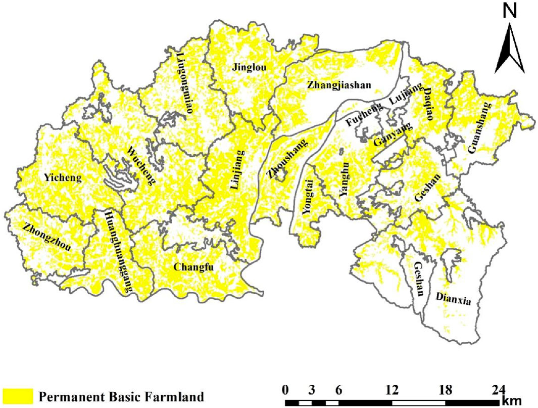
Figure 4. Classification results of permanent basic farmland in Zhangshu city.
Looking at the division results, Wucheng Township has the largest area of permanent basic farmland in Zhangshu City among all the townships, reaching 4,800.61 ha, accounting for 11.11% of the total permanent basic farmland in Zhangshu City. Following that, Linjiang Township, Yicheng Township, Jinglou Township, and Changfu Township have retained 4,289.80, 3,764.10, 3,476.25, and 3,028.73 ha of permanent basic farmland, respectively. The townships with relatively smaller areas of retained permanent basic farmland include Lujiang Street Office, with an area of 10.91 ha, followed by Fucheng Street Office, and Ganxiang Street Office, with areas of 40.76 and 178.23 ha, respectively. The main reason for these townships having smaller areas of retained permanent basic farmland is their proximity to the urban area of Zhangshu City.
3.3 Zoning and control of permanent basic farmland
The designated permanent basic farmland is further classified into three categories: the core protection zone of permanent basic farmland, the quality improvement zone of permanent basic farmland, and the key renovation zone of permanent basic farmland (Figures 5A,B). In terms of spatial distribution, the core protection zone of permanent basic farmland is primarily located in the southwestern part of Zhangshu City. The quality improvement zone of permanent basic farmland is widely distributed throughout the city, while the key renovation zone of permanent basic farmland is mainly found in the northern areas of Zhangshu City, particularly in the suburban regions, with scattered parcels in other areas (Figure 5A).
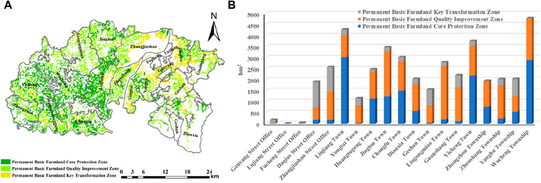
Figure 5. Classification and control zones of permanent basic farmland in Zhangshu city.
As shown Figure 5B, the area of the core protection zone of permanent basic farmland is 15,481.05 ha, accounting for 35.82% of the total permanent basic farmland, the quality improvement zone of permanent basic farmland covers an area of 21,172.95 ha, representing 48.99%, and the key renovation zone of permanent basic farmland encompasses 6,564.81 ha, accounting for 15.19%. When looking at individual townships, the core protection zone of permanent basic farmland is mainly located in Linjiang Township, Wucheng Township, Yicheng Township, and Changfu Township, with areas of 3,027.90, 2,902.55, 2,195.43, and 1,505.31 ha, respectively. In contrast, townships with smaller arable land areas are not included in the core protection zone of permanent basic farmland. The arable land in Ganxiang Street Office, Lujiang Street Office, and Fucheng Street Office is not within the core protection zone.
The quality improvement zone of permanent basic farmland primarily covers arable land in Liugongmiao Township, Jinglou Township, Wucheng Township, and Guanshang Township. In contrast, Ganxiang Street Office, Lujiang Street Office, and Fucheng Street Office have fewer arable land parcels designated as part of the quality improvement zone of permanent basic farmland.
Within the key renovation zone of permanent basic farmland, Diao Street Office and Zhangjiashan Street Office have relatively larger areas of arable land, with 1,161.96 and 1,106.05 ha, respectively. Other townships also have some arable land designated for key renovation of permanent basic farmland.
4 Discussion
4.1 Comparison with the division results of the original permanent basic farmland
As pointed out in the article, Zhangshu City has allocated a total of 43,218.80 ha of permanent basic farmland, accounting for 79.35% of the total arable land area. In order to better reflect the differences between the permanent basic farmland designated by the method in this article and the originally designated permanent basic farmland, We conducted a comparative analysis between the two. Through spatial overlay, the overlaid results were categorized into three classes: retained permanent basic farmland, added permanent basic farmland, and removed permanent basic farmland.
As shown in the Figure 6, retained permanent basic farmland refers to the overlapping area between the current designated permanent basic farmland and the original designated permanent basic farmland. This area covers 42,466.06 ha, accounting for 98.26% of the total area of permanent basic farmland designated in this study. This portion of arable land constitutes the core of Zhangshu City’s permanent basic farmland and is primarily located in the western and northeastern regions. The soil in this area is relatively thick, with gentle slopes, fertile soil, no heavy metal pollution, high plot continuity, reasonable scale, high agricultural production stability, and minimal impact from urban development. It embodies the concentration of high-quality arable land in Zhangshu City. This indicates that the current designated permanent basic farmland is largely consistent with the original designated permanent basic farmland.
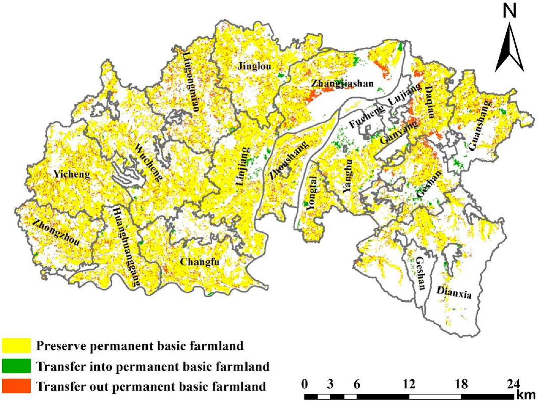
Figure 6. Comparison of permanent basic farmland division in Zhangshu city.
Added permanent basic farmland refers to land designated as permanent basic farmland in this study but not included in the current planning, classified as general arable land. The area of this type of arable land is 1,532.10 ha, accounting for 3.54% of the total permanent basic farmland designated in this study. In this study, after considering arable land suitability, continuity, and stability comprehensively, land parcels around urban areas that met the criteria were designated as permanent basic farmland to achieve the goal of designating as much permanent basic farmland as possible and to enhance permanent basic farmland protection efforts.
Removed permanent basic farmland represents land parcels designated as permanent basic farmland in the current planning but not designated as such in this study. The area of these land parcels is 9,226.40 ha, accounting for 21.35% of the total area of permanent basic farmland designated in this study. These parcels are primarily located in Zhangjiashan Street Office, Diao Street Office, with scattered parcels in other areas. The removal of these land parcels is mainly due to poor suitability, fragmentation, and low stability. By removing them, further optimization of permanent basic farmland is achieved. Through comparison, it can be found that using the method of the article to divide permanent basic farmland can further optimize the spatial pattern of permanent basic farmland, avoiding the problems that arise from the original method of dividing permanent basic farmland in the current planning.
4.2 Protection strategies of permanent basic farmland
Arable land protection has always been the focus of the Chinese government (Wu et al., 2017b; Liu et al., 2017), permanent basic farmland, as the essence of arable land, is urgently needed in China. Delineating and protecting permanent basic farmland is of great significance for improving the quality of arable land and ensuring national food security (Deng et al., 2015). We have further divided the identified permanent basic farmland in article, the area of the core protection zone of permanent basic farmland is 15,481.05 ha, accounting for 35.82% of the total permanent basic farmland, the quality improvement zone of permanent basic farmland covers an area of 21,172.95 ha, representing 48.99%, and the key renovation zone of permanent basic farmland encompasses 6,564.81 ha, accounting for 15.19%.Therefore, targeted measures are proposed for the construction and protection of permanent basic farmland, which could have a positive effect on the protection of permanent basic farmland. First, priority should be given to assigning arable land with high connectivity, stability, and suitability to permanent basic farmland based on research, solving the problem of basic farmland space fragmentation and distant delineation, poor optimization (Chen et al., 2021). At present, some permanent basic farmland of the key renovation zone in Zhangshu City is still located on mountains with poor suitability, connectivity, and stability. We should adjust and optimize it. As is known to all, permanent basic farmland should be regarded as the core protected areas of permanent basic farmland, and we should strengthen protection and prohibit any project construction from occupying them. Second, for the fragmentation and irregularity of farmland, carry out field leveling engineering, level the land, and reasonably arrange the field road network to achieve the improvement of farmland utilization efficiency after rectification. By renovating, this type of farmland will become a high standard basic farmland (Sun et al., 2023). Zhangshu City is implementing a high standard farmland construction plan, which aims to convert all permanent basic farmland into high standard farmland by 2035. By then, the quality of permanent basic farmland will be further improved. Especially, the area of the core protection zone of permanent basic farmland should be converted into high standard farmland first, followed by the quality improvement zone of permanent basic farmland and the key renovation zone of permanent basic farmland. Third, for farmland with certain soil conditions that are still suitable for permanent basic farmland, efforts should be made to renovate it. On the basis of increasing the rectification of the field road network and leveling the fields, organic fertilizer should also be applied to fertilize the soil, improve soil structure, and increase soil fertility.
4.3 Policy implications and prospects of the research
This study, based on the quality classification of arable land resources, combined the classification results with the requirements for designating permanent basic farmland. It conducted a plot-scale evaluation of “suitability-continuity-stability” for arable land resources and optimized permanent basic farmland based on the evaluation results. This theoretical method not only applies the results of arable land resource quality classification to the designation of permanent basic farmland, providing a clear description of arable land resource characteristics while avoiding the influence of subjective factors on permanent basic farmland designation but also categorizes permanent basic farmland into different types. This allows for efficient classification and control of permanent basic farmland and clarifies the limiting factors for different types of permanent basic farmland. This makes it easier to plan engineering measures precisely during the gradual construction of high-standard farmland, supporting the process of turning permanent basic farmland into high-standard farmland. Thus, the approach used in this study, based on arable land resource quality classification, is theoretically and temporally beneficial. It not only applies the results of arable land resource quality classification to the optimization of permanent basic farmland but also applies the study’s results to the process of constructing high-standard farmland, enabling the differential development of high-standard farmland and supporting the unified management of natural resources.
Of courses, this method also has certain limitations. This method may have the problem of high data accuracy and requiring a large amount of data. Therefore, when using this method for analysis, it is necessary to have data on the quality of cultivated land at the plot scale to ensure the reliability of the results.
5 Conclusion
This study, based on national requirements for permanent basic farmland, constructed an evaluation system for permanent basic farmland based on “suitability-continuity-stability”. Following the requirements for designating permanent basic farmland, an evaluation system for permanent basic farmland was established, considering suitability, continuity, and stability. In Zhangshu City, arable land is primarily highly and moderately suitable. Regarding arable land continuity, high and moderate continuity are prominent. In terms of arable land stability, high stability predominates. The designated permanent basic farmland is categorized into three types: the core protection zone of permanent basic farmland, the quality improvement zone of permanent basic farmland, and the key renovation zone of permanent basic farmland. These zones cover areas of 15,481.05, 21,172.95, and 6,564.81 ha, respectively.
Data availability statement
The original contributions presented in the study are included in the article/supplementary material, further inquiries can be directed to the corresponding author.
Author contributions
WW: Writing–original draft. YC: Methodology, Writing–original draft. KY: Writing–review and editing. YD: Writing–review and editing. GL: Methodology, Writing–original draft. LW: Conceptualization, Writing–review and editing. YC: Writing–review and editing.
Funding
The author(s) declare that financial support was received for the research, authorship, and/or publication of this article. Jiangxi Provincial Forestry Bureau Forestry Science and Technology Innovation Special Project (Innovation Special [2022] No. 17), Construction of Planning Environmental Impact Assessment Model and Development of Planning Support System Based on GIS Technology (Jiangxi Provincial Geological Bureau Innovation Project).
Conflict of interest
The authors declare that the research was conducted in the absence of any commercial or financial relationships that could be construed as a potential conflict of interest.
Publisher’s note
All claims expressed in this article are solely those of the authors and do not necessarily represent those of their affiliated organizations, or those of the publisher, the editors and the reviewers. Any product that may be evaluated in this article, or claim that may be made by its manufacturer, is not guaranteed or endorsed by the publisher.
References
Arrouays, D., Forges, A. R. D., and Morvan, X. (2009). Environmental assessment of soil for monitoring. J. Cell Biol. 146, 146–869.
Bernues, A., Tello-Garcia, E., Rodriguez-Ortega, T., Ripoll-Bosch, R., and Casasus, I. (2016). Agricultural practices, ecosystem services and sustainability in High Nature Value farmland: unraveling the perceptions of farmers and nonfarmers. Land Use Policy 59, 130–142. doi:10.1016/j.landusepol.2016.08.033
Cao, C., and Song, W. (2022). Progress and prospect of ecological risks of land use change. Front. Environ. Sci. 10, 1077515. doi:10.3389/fenvs.2022.1077515
Chen, Y., Yao, M., Zhao, Q., Chen, Z., Jiang, P., Li, M., et al. (2021). Delineation of a basic farmland protection zone based on spatial connectivity and comprehensive quality evaluation: a case study of Changsha City, China. Land Use Policy 101, 105145. doi:10.1016/j.landusepol.2020.105145
Cheng, L., Jiang, P. H., Chen, W., Li, M. C., Wang, L. Y., Gong, Y., et al. (2015). Farmland protection policies and rapid urbanization in China: a case study for Changzhou City. Land Use Policy 48, 552–566. doi:10.1016/j.landusepol.2015.06.014
Deng, X., Huang, J., Rozelle, S., Zhang, J., and Li, Z. (2015). Impact of urbanization on cultivated land changes in China. Land Use Policy 45, 1–7. doi:10.1016/j.landusepol.2015.01.007
Fan, J., Wang, L., Qin, J., Zhang, F., and Xu, Y. (2020). Evaluating cultivated land stability during the growing season based on precipitation in the Horqin Sandy Land, China. Environ. Manage. 276, 111269. doi:10.1016/j.jenvman.2020.111269
Fazel, R., Rossana, M., Hossein, A. B., Zahra, F., and Sima, R. B. (2014). Assessment of soil quality indices in agricultural lands of Qazvin Province, Iran. Ecol. Indic. 40, 19–26. doi:10.1016/j.ecolind.2013.12.003
Ge, D., Long, H., Zhang, Y., Ma, L., and Li, T. (2018). Farmland transition and its influences on grain production in China. Land Use Policy 70, 94–105. doi:10.1016/j.landusepol.2017.10.010
Guan, X., Wang, X., Zhang, J., and Dai, Z. (2023). Regulation and optimization of cultivated land in different ecological function areas under the guidance of food security goals-a case study of Mengjin County, Henan Province, China. Front. Environ. Sci. 11, 1115640. doi:10.3389/fenvs.2023.1115640
Guo, G., and Han, X. (2021). Optimization of county-level basic farmland spatial layout considering food security and farmland quality. Trans. Chin. Soc. Agric. Eng. 37, 252–260. (In Chinese with English Abstract).
Lambin, E. F., Gibbs, H. K., Ferreira, L., Grau, R., Mayaux, P., Meyfroidt, P., et al. (2013). Estimating the world's potentially available cropland using a bottom-up approach. Glob. Environ. Change 23, 892–901. doi:10.1016/j.gloenvcha.2013.05.005
Liang, C., Penghui, J., Wei, C., Manchun, L., Liyan, W., Yuan, G., et al. (2015). Farmland protection policies and rapid urbanization in China: a case study for Changzhou City. Land Use Policy 48, 552–566. doi:10.1016/j.landusepol.2015.06.014
Lin, J., Liu, Q., and Li, J. (2016). Development of a selective and fast LC-MS/MS for determination of WSJ-537, an xanthine oxidase inhibitor, in rat plasma: application to a pharmacokinetic study. Urban Dev. Res. 23, 51–55. (In Chinese with English Abstract). doi:10.1016/j.jchromb.2016.05.039
Liu, L., Zhou, D., Chang, X., and Lin, Z. (2020b). A new grading system for evaluating China’s cultivated land quality. Land Degrad. Dev. 31, 1482–1501. doi:10.1002/ldr.3547
Liu, P., Wu, K., Zhao, H., et al. (2015). Optimization of basic farmland layout based on comprehensive farmland quality: a case study of Wen County, Henan Province. China Land Sci. 29, 54–59. (In Chinese with English Abstract).
Liu, X., Zhao, C., and Song, W. (2017). Review of the evolution of cultivated land protection policies in the period following China’s reform and liberalization. Land Use Policy 67, 660–669. doi:10.1016/j.landusepol.2017.07.012
Liu, Y., Fang, F., and Li, Y. (2014). Key issues of land use in China and implications for policy making. Land Use Policy 40, 6–12. doi:10.1016/j.landusepol.2013.03.013
Liu, Y., Liu, L., Zhu, A., Lao, C., Hu, G., and Hu, Y. (2020a). Scenario farmland protection zoning based on production potential: a case study in China. Land Use Policy 95, 104581. doi:10.1016/j.landusepol.2020.104581
Liu, Y., Zhang, Y., and Guo, L. (2010). Towards realistic assessment of cultivated land quality in an ecologically fragile environment: a satellite imagery-based approach. Appl. Geogr. 30, 271–281. doi:10.1016/j.apgeog.2009.07.002
Lu, X., and Li, J. (2022). Discussion on the optimization and adjustment of permanent basic farmland under the background of national land spatial planning. Mod. Agric Sci Tech 24, 112–115. (In Chinese with English Abstract).
Nosrati, K., and Collins, A. L. (2019). A soil quality index for evaluation of degradation under land use and soil erosion categories in a small mountainous catchment, Iran. Sci.-Engl. 16, 2577–2590. doi:10.1007/s11629-019-5567-8
Peng, L., Hu, Y., Li, J., and Du, Q. (2017). An improved evaluation scheme for performing quality assessments of unconsolidated cultivated land. Sustainability 9, 1312. doi:10.3390/su9081312
Qi, X., Fu, Y., Wang, R. Y., Ng, C. N., Dang, H., and He, Y. (2018). Improving the sustainability of agricultural land use: an integrated framework for the conflict between food security and environmental deterioration. Appl. Geogr. 90, 214–223. doi:10.1016/j.apgeog.2017.12.009
Qian, F., Lal, R., and Wang, Q. (2021). Land evaluation and site assessment for the basic farmland protection in Lingyuan County, Northeast China. J. Clean. Prod. 314, 128097. doi:10.1016/j.jclepro.2021.128097
Qianwen, C., Penghui, J., Lingyan, C., Jinxia, S., Yunqian, Z., Liyan, W., et al. (2017). Delineation of a permanent basic farmland protection area around a city centre: case study of Changzhou City, China. Land Use Policy 60, 73–89. doi:10.1016/j.landusepol.2016.10.014
Song, W., Zhang, H., Zhao, R., Wu, K., Li, X., Niu, B., et al. (2022). Study on cultivated land quality evaluation from the perspective of farmland ecosystems. Ecol. Indic. 139, 108959. doi:10.1016/j.ecolind.2022.108959
Steiner, F. (1987). Agricultural land evaluation and site assessment in the United States: an introduction. Environ. Manage. 11, 375–377. doi:10.1007/bf01867166
Sun, X., Li, Q., Kong, X., Cai, W., Zhang, B., and Lei, M. (2023). Spatial characteristics and obstacle factors of cultivated land quality in an intensive agricultural region of the north China plain. Land 12, 1552. doi:10.3390/land12081552
Vidal Legaz, B., Maia De Souza, D., Teixeira, R. F. M., Antón, A., Putman, B., Sala, S., et al. (2017). Soil quality, properties, and functions in life cycle assessment: an evaluation of models. J. Clean. Prod. 140, 502–515. doi:10.1016/j.jclepro.2016.05.077
Vogel, H.-J., Eberhardt, E., Franko, U., Lang, B., Ließ, M., Weller, U., et al. (2019). Quantitative evaluation of soil functions: potential and state. Front. Environ. Sci. 7, 164. doi:10.3389/fenvs.2019.00164
Wang, X. Q., Shi, W. J., Sun, X. F., and Wang, M. Comprehensive benefits evaluation and its spatial simulation for well-facilitated farmland projects in the Huang-Huai-Hai Region of China and its spatial simulation for well-facilitated farmland projects in the Huang-Huai-Hai Region of China. Land Degrad. Dev., 2020. 31. 1837–1850. doi:10.1002/ldr.3566
Wu, F., Mo, C., Dai, X., and Li, H. (2022). Spatial analysis of cultivated land productivity, site condition and cultivated land health at county scale. Int. J. Environ. Res. Public Health 19, 12266. doi:10.3390/ijerph191912266
Wu, Y., Shan, L., Guo, Z., and Peng, Y. (2017a). Cultivated land protection policies in China facing 2030: dynamic balance system versus basic farmland zoning. Habitat Int. 69, 126–138. doi:10.1016/j.habitatint.2017.09.002
Wu, Y., Shan, L., Guo, Z., and Peng, Y. (2017b). Cultivated land protection policies in China facing 2030: dynamic balance system versus basic farmland zoning. Habitat Int. 69, 126–138. doi:10.1016/j.habitatint.2017.09.002
Xia, N., Wang, Y., Xu, H., Sun, Y., Yuan, Y., Cheng, L., et al. (2016). Demarcation of prime farmland protection areas around a metropolis based on high-resolution satellite imagery. Sci. Rep. 6, 37634. doi:10.1038/srep37634
Xu, E., and Zhang, H. (2013). Spatially-explicit sensitivity analysis for land suitability evaluation. Appl. Geogr. 45, 1–9. doi:10.1016/j.apgeog.2013.08.005
Xue, Y. J., Liu, S. G., Hu, Y. M., and Yang, J. F. (2010). Soil quality assessment using weighted fuzzy association rules. Pedosphere 20, 334–341. doi:10.1016/s1002-0160(10)60022-7
Zhang, H., Li, M., and Zhang, Q. (2020). Construction of land classification system for national land spatial planning based on multi-source data and land type identification. Trans. Chin. Soc. Agric. Eng. 36, 261–269. (In Chinese with English Abstract).
Zhao, Y., Luo, Z., Cao, L., Zhong, S., and Zhao, J. (2019). Layout optimization of regional urban development and agricultural production based on spatial decision-making: a case study of Linchuan district in Jiangxi province. J. Nat. Res. 34, 526–538. (In Chinese with English Abstract). doi:10.31497/zrzyxb.20190307
Keywords: quality classification, permanent basic farmland, space optimization, classification control, Zhangshu city
Citation: Wang W, Chen Y, Liu K, Dang Y, Li G, Wen L and Cao Y (2024) Optimization and classification control of permanent basic farmland based on quality classification. Front. Environ. Sci. 12:1331534. doi: 10.3389/fenvs.2024.1331534
Received: 06 November 2023; Accepted: 27 March 2024;
Published: 10 April 2024.
Edited by:
Jose Antonio Rodriguez Martin, Instituto Nacional de Investigación y Tecnología Agroalimentaria (INIA), SpainReviewed by:
Rui Zhao, China State Farms Economic Development Center, ChinaTesfahun Endalew, Salale University, Ethiopia
Copyright © 2024 Wang, Chen, Liu, Dang, Li, Wen and Cao. This is an open-access article distributed under the terms of the Creative Commons Attribution License (CC BY). The use, distribution or reproduction in other forums is permitted, provided the original author(s) and the copyright owner(s) are credited and that the original publication in this journal is cited, in accordance with accepted academic practice. No use, distribution or reproduction is permitted which does not comply with these terms.
*Correspondence: Liangyou Wen, wenly92@126.com