System effects mapping: a tool for promoting collaborative community ecological action
 Virginia Baker1,2
  Suzanne Manning
 Jamie Ataria
- 1Institute of Environmental Research and Science, Porirua, New Zealand
- 2School of Humanities, University of Adelaide, Adelaide, SA, Australia
- 3Cawthron Institute, Nelson, New Zealand
- 4EcoMatters Environmental Trust, Auckland, New Zealand
- 5Te Kawerau ā Maki, Te Kawerau Iwi Settlement Trust, Auckland, New Zealand
Across Indigenous scholarship and environmental sciences there is a growing recognition that community and stakeholder partnerships must underpin and guide the co-production of knowledge to better resolve the complex socio-political issues responsible for the production, and ultimately the mitigation, of pollution. This article reports work that aimed to support shared understanding within community stakeholder partners as part of two larger environmental science projects to understand and reduce pollution within an urban waterway. Utilizing participatory action research, transdisciplinary and translational ecology approaches, the research used System Effects Mapping to visualize a networked understanding of people’s connections to, and valuing of, their local water ways. This led to discussions on ways that community stakeholders felt they could act to improve the environmental conditions, taking into account how actions may interact. While actions identified were not necessarily novel, the approach supported shared understanding between researchers and community stakeholders and shared investment in the knowledge produced. Systems Effects Mapping was a useful method, with the social network output allowing for deeper exploration of transdisciplinary systems change.
1 Introduction
This paper presents a community collaboration utilizing a novel engagement method as part of two linked multidisciplinary environmental research projects in Aotearoa-New Zealand (Aotearoa). Managing the Risk of Organic Contaminants (EOCs) and Aotearoa Impacts and Mitigation of Microplastics (AIM2) projects focused on better understanding the sources, environmental impacts of contaminants and reducing their impacts in the environment. These contaminants include pharmaceuticals, ingredients in cleaning and personal care products, and microplastics and their associated chemical contaminants.
The use of plastics and chemicals are deeply embedded in our society and are integral to human lifestyle and health. Poor management and disposal practices surrounding their production and consumption result in the release of contaminants into the environment. The effects of these contaminants as components of wastewater discharges, stormwater and run-off, litter, and their potential accumulation in ecosystems including estuaries, are of increasing concern (Davison et al., 2021; Kramm et al., 2022).
Reducing the impacts of plastics and chemicals is a significant challenge, and one that is considered to be a ‘wicked problem’ where people are implicitly part of the problem and there are no simple solutions (Rittel and Webber, 1973; Head, 2008; Lönngren and Van Poeck, 2021). Mitigation would require significant change in everyday life, systemic redesign of policy, and alterations to production and practices across diverse sectors. The complex, multi-faceted sociocultural and political factors associated with mitigation and adaptation need to be better understood by communities, regulators and scientists for science research to have a significant impact. This makes it vital that communities and local stakeholders are meaningfully involved in how the science frames the problems, and the design of any potential interventions (Brown et al., 2010; Jahn et al., 2012; Brandt et al., 2013).
We developed a mixed-method transdisciplinary approach for collaborative planning and critical reflection. Key to the approach was Te Tiriti o Waitangi, guiding partnership with Indigenous Māori as key decision-makers within the geographical area and project (Hepi et al., 2018; Ataria et al., 2023). A central and defining premise of transdisciplinarity is the degree to which local knowledge and experiences are integral to the research (Brown et al., 2010; Jahn et al., 2012; Baker et al., 2023), and the degree of power and influence that community and Indigenous knowledge systems have in shaping and interpreting the research (Jahn et al., 2012; Goven et al., 2015). Further, translation ecology integrates ecological and social science to link scientific knowledge with decision making and action, using transdisciplinary approaches. Including local council decision makers in the study alongside community and Indigenous partners supported dialogue across mental models about environmental management arising from Western scientific, Indigenous, and experiential knowledges, which is an essential part of translational ecology (Foote et al., 2007; Enquist et al., 2017; Safford et al., 2017). All these features support meaningful change through shifts in thinking and practices of those involved (Parsons et al., 2016; 2017; Enquist et al., 2017).
This community case study used systems effects mapping as a tool for co-exploration and joint framing of the issues around the health of local urban waterways. As this work was carried out during the COVID-19 pandemic, there were many challenges to the original research plan. In particular, the plan relied heavily on face-to-face interactions as the preferred method of interaction for the community and Māori partners, and the pandemic resulted in cancellation of many of the larger scale events. Further, the community and Māori groups were involved in supporting others during the difficult times of the pandemic. Despite these challenges, the objective of providing a forum for shared understanding of the wider science project findings was achieved, and areas to increase the community’s ‘capacity to act’ were identified.
The rest of the article describes the case study. The context of the Whau case study is presented, followed by an outline of the systems effects mapping tool and how it was used. The findings are presented and then reflected on in the final section.
2 The Whau case study
The geographical area of interest was the Whau river catchment, an urban estuarine system in the west of Auckland City, Aotearoa New Zealand. Historically the Whau river was a valuable link between the West and East coast of the North Island of Aotearoa via portage between the large western (Manukau) and eastern (Waitematā) harbors. The Whau was an important trading area for Māori (indigenous peoples of Aotearoa) because of its location, rich biodiversity and bountiful food resources that supported many people. Te Kawerau ā Maki (TKAM) is recognized as mana whenua, being the Māori tribe having principal cultural authority over the Whau catchment area.
Following the signing of Te Tiriti o Waitangi in 1840 between Iwi (Māori tribes) and the British Crown, there was a large influx of immigrants from Britain and significant marginalization of the Indigenous population. British colonialists used the water of the Whau river as an industry resource but also as a vehicle to discharge waste as urban, industrial, and horticultural developments expanded adjacent to the river. By the end of the 20th century, the Whau river was recognized as significantly polluted. By 2020, environmental efforts had failed to significantly mitigate pollution levels, with reporting continuing to show that human induced pollution via accumulation of contaminants within sediment (Mills and Allen, 2021) is impacting on the benthic ecology (Drylie, 2021). Both community environmental groups and Māori mana whenua had expressed their concerns about the pollution. This combination of a polluted environment and active community engagement in seeking solutions made the area ideal for a case study within the EOCs and AIM2 projects. The case study included both biophysical and social science objectives, however this paper reports on a specific research method as used in the social science components of the inquiry, that is, the use of the systems effects mapping as a tool for further supporting dialogue and shared understandings.
An essential first step was to establish a Community Steering Group (CSG) with representation from TKAM (mana whenua/Iwi), EcoMatters (a community environmental group), and Auckland Council (local government). The purpose of the CSG was to guide a collaborative planning approach with the project researchers. As part of the researchers’ commitment to a partnership approach, the initial phase of the research focused on setting up the CSG including a Terms of Reference document, and agreements for sharing information and intellectual property. The key community and Iwi partnerships in the project were resourced for their time, expertise, expenses, and involvement. Whilst not necessarily equating to renumeration that researchers would typically receive, allocating adequate funds to support community and mana whenua partnerships over the duration of the project was essential to ensure participation could be meaningful, including signifying an intent for more equitable power dynamics in the research relationships.
The initial part of the project was to identify the community partners’ priority project aims. At several half-day face-to-face and online meetings facilitated by the researchers, soft systems tools including rich pictures (Checkland and Poulter, 2010; Bell and Morse, 2013) and collaborative planning methods were used to help the CSG develop a shared understanding of the current situation. From these meetings the name ‘Te Hau o te Whau’ was gifted by TKAM, to describe the intent for restoration and recognition of the essence and vitality of the Whau waterway and catchment. The CSG agreed the research would be conducted in ways that supported and strengthened the ‘community’s capacity to act’ to restore the health and spirit, or mauri of the Whau waterway and catchment, that made visible TKAM history in the area and supported a sense of community connection to the waterways. Thus, the research aimed to identify ways for communities to better understand and connect the sources of plastics and contaminants in their journey from land to ocean via the Whau, as well as options to better manage those contaminants. As the project progressed, regular CSG meetings enabled the scientists to learn about, connect with, and participate in local environmental activities, give updates on the wider research and co-design the research.
Systems effects mapping was one tool that was used to advance the aims of Te Hau o te Whau by gathering data and presenting in a visual form. Systems Effects Mapping had three purposes within Te Hau of te Whau: 1) support shared understanding between members of CSG and researchers; 2) help consider ‘community connection’ to urban waterways; 3) help consider community capacity to act for health of urban waterways. Overall, we attempted to show how people in the community understand the links between factors which affect the health and vitality of the river.
3 Methods—system effects mapping
System effects mapping is a method initially developed by Luke Craven (2017). The method combines soft systems approaches with social network analysis and mapping to identify and analyze influencing factors in a system. Soft systems approaches focus on making explicit people’s mental models about a system, which is useful for influencing individuals’ behaviors and practices as well as identifying opportunities for systemic action (Midgley, 2000; Moon et al., 2019; Biedenweg et al., 2020). Social network analysis allows combination of multiple individual perspectives of an issue, to consider interactions of factors across these multiple perspectives, and to reveal influence or ‘leverage’ points. Systems effects is a relatively recent method development, with application to date in areas such as public health and equity in technology. Examples are a study on how people perceive the risk of mosquito-borne disease in Vietnam (Chapot et al., 2020) or what systemic barriers create uneven access to digital finance technologies in Bangladesh (Boamah et al., 2021), or the impact of unsafe food in Cambodia (Roesel et al., 2021). An online survey was created using the system effects tool (https://www.systemeffects.com/#/). This tool provided an easy way for people to contribute to the study, and see their individual ‘map’ of influencing factors and change it in real time if they chose. Network analysis statistics were not utilized as the key intended use of the System Effects Mapping was to support dialogue on different perspectives of what supports healthy urban waterways, in order to better identify points of leverage and actions for the CSG to consider. For this reason, analysis of the System Effects survey responses was kept to a visual display of the resulting network.
A summary diagram with an outline of the research process is shown in Table 1.
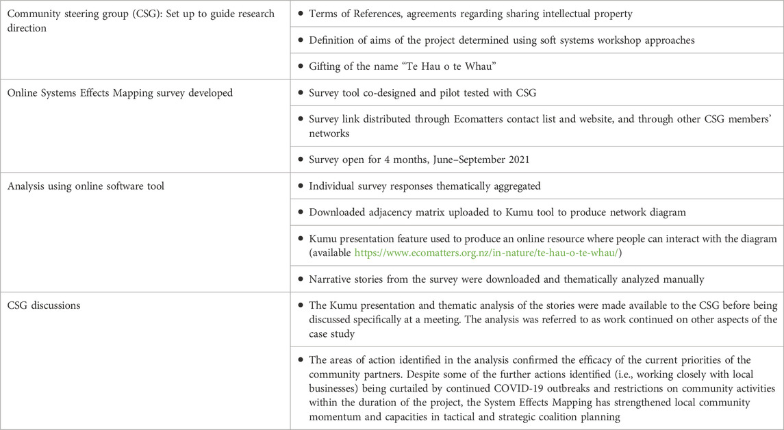
TABLE 1. Outline of Systems Effects Mapping research process.
Members of the CSG distributed a link to the online survey through their networks, including EcoMatters newsletter. The participants were therefore not geographically limited to the Whau river catchment and included responses from other catchment areas. While the Whau river was focus of the case study, pollution issues within the Whau are not unique and perspectives on urban waterways more generally were relevant to study purpose.
The central question of the Systems Effects Mapping survey was “what contributes to a thriving urban waterway”. Respondents were asked about contributing factors that they thought were important for a healthy waterway, and what other things might influence, or be influenced by, that factor. As we used the method to explore ways to enhance the ‘community capacity to act’, we deliberately asked positively framed questions and avoided asking about barriers. This decision was also to minimize triggering feelings of anxiety concerning the environment (Hayes et al., 2018). The systems effects tool drew a network map of factors and respondents were asked to make additional connections between factors which they identified. A further option was provided to ‘tell a story’ about actions they have taken to support a healthy waterway. Finally, demographic questions were asked related to waterways.
Factors identified within individual survey responses were only combined across responses where it was considered that similar factors influencing health of waterways were described using different words. Keeping a diversity of factors and representing diversity of perspectives were key considerations in combining the individual survey responses into a single dataset. Combined responses were uploaded as an adjacency matrix to the Kumu tool to produce a network diagram (https://kumu.io/). The stories were analyzed separately using manual thematic analysis, focusing on identifying community ‘capacity to act’.
An interactive presentation of the Kumu network diagram was created to explain the network diagram to the CSG for use in their decision making around future direction for the research. The presentation also included an explanation and visual summary of the themes from the stories. The presentation was discussed at a CSG meeting, and was subsequently made available on the Ecomatters webpage along with other outputs from the case study (see https://www.ecomatters.org.nz/in-nature/te-hau-o-te-whau/).
4 Findings
Within the demographic section, respondents were asked about connections with their local waterway (Table 2). Fourteen of 37 respondents completing demographic questions identified their local waterway as the Whau river, estuary or tributary. Most respondents saw their local waterway often and felt a sense of connection to that waterway. Given these results, the small sample size and the way that the survey link was distributed, we acknowledge that the findings may not necessarily be representative of the views of the wider community, but instead reflect the views of individuals with a pre-existing sense of environmental connection who were motivated to complete the survey. Nevertheless, a variety of factors influencing health of waterways were identified, from individual practices through to urban planning rules and design. Given this breadth of factors, the results were helpful in supporting the study purpose of building knowledge for dialogue and shared understandings.
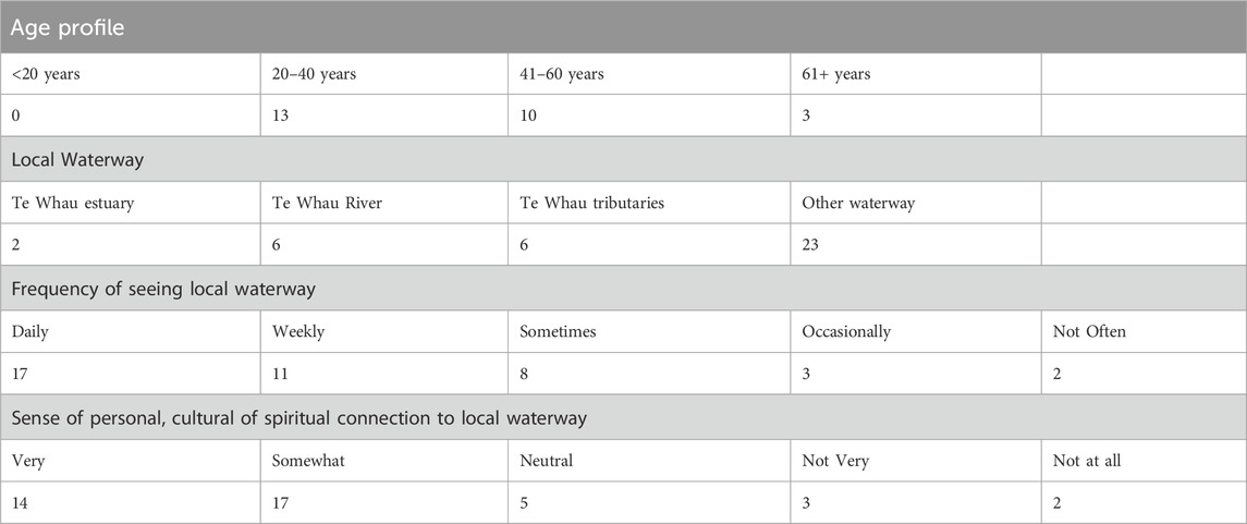
TABLE 2. Demographic profile of respondents to Systems Effects Mapping survey, reported as numbers of respondents. n = 41 but note that not all respondents answered every question.
A visualization of the network diagram is presented in Figure 1. The nodes are aggregated factors proposed by respondents as being important for a healthy waterway and are connected to other factors that were thought to influence, or be influenced by, the first factor. The size of the connections is weighted according to the number of respondents who identified those connections. The shape of the nodes indicates the visible/invisible categorizations assigned by the research team. Visible elements (circles) can be seen, heard, or smelt, for example, the presence of rubbish, the clarity of the water, or impact of a sewage overflow event. Invisible elements (triangles) are less obvious, including chemical contaminants, stormwater systems, and local government resource consenting processes (rules and required conditions) for discharge and monitoring wastewater. The purpose of these categories was to stimulate discussion about relative visibility of nodes. The CSG discussion on this point was rich with varied opinions as to which elements should be considered “visible” or “invisible”. While no consensus was reached, a greater depth of understanding was generated within the group of the system that contributed to the health of the Whau.
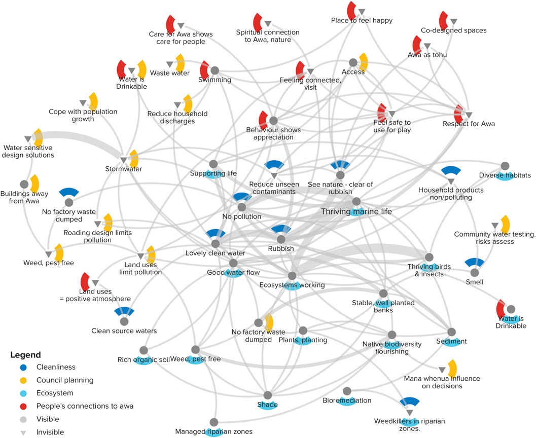
FIGURE 1. Te Hau o te Whau Factors creating a thriving awa/river.
To assist with making sense of the complex diagram, color coding was used to distinguish the alternative categorization of what the factor was associated with, which we termed its ‘location’ within the system. Dark blue was for the cleanliness of the waterway itself; yellow was for factors that are controlled by local government such as water infrastructure or environmental monitoring; light blue was for the ecosystem factors that indicate a healthy waterway such as plants and marine life; and red was for factors associated with how people feel about, use, or take action on the waterway.
Twenty-six respondents provided a story of an action which they had taken to support a thriving and healthy waterway. Overall, there was a strong sense of connection with local waterways and an appreciation of the value of waterways. Comments included: ‘waterways are super important and [are] the bloodlines of our land and sea’ and ‘water is life’. The stories emphasized the extent to which respondents were committed to caring for the environment, such as being involved in environmental education or volunteering in stream clean-ups to remove visible rubbish and litter. Active connections with waterways were important for respondents for mental wellness, bringing joy, peace and relaxation, as well as fond memories of childhood play in and around the water. Connections were also important for shaping practices of using and caring for the waterways, including water skills and boat craft, and removing rubbish.
Some actions that protected and enhanced the quality of the waters were identified. These included advocating for keeping the large established trees by riversides for habitat and shade, education about habitats in parks, litter removal and tree planting. Given the size and difficulty accessing some of the streamside litter encountered, people were relieved to be able to contact the Council/local government for help. Local government was seen as a key partner in supporting ‘community capacity to act’.
When the network diagram was discussed by the CSG, there were insights into how each partner group was represented or not in the diagram. A summary of the insights from the discussion is given in Table 3. Of note were the observations that the diagrams identified a wider range of factors than any individual within the group would have identified, and that factors were both in and outside the water. Connections were considered to provide ideas about possible places to intervene to protect this natural resource. The diagram acted to challenge theories of change about specific intervention options. For example, education for households about environmentally friendly product choices is often an action that is promoted as effective. However, the system map found less connections with this node and more connections with intersecting activities relating to a well-functioning ecosystem, which was placed near the centre of the network. This suggests that householder education in the absence of other intervention may not result in system change. The network diagram supported moving dialogue from considering single interventions towards a more systemic understanding of how multiple interventions interact (Midgley, 2000). Overall, the network diagram and action-story results confirmed the importance of removing visible rubbish to create a sense of wellbeing and connection in those people who care about the river, as well as the value of concurrent streamside restoration work including pest trapping and native plantings. The affirmation of the value of the current activities being undertaken was welcomed in coalescing hope and conveying a greater sense of effectiveness in the combined range of activities already undertaken by the CSG. The use of System Effects Mapping also helped strengthen local capacities and capabilities in networked knowledge building, and in the closing phases of the project this led to the CSG establishing and formalizing a local coalition alliance to strengthen the momentum of combined community and stakeholder action.
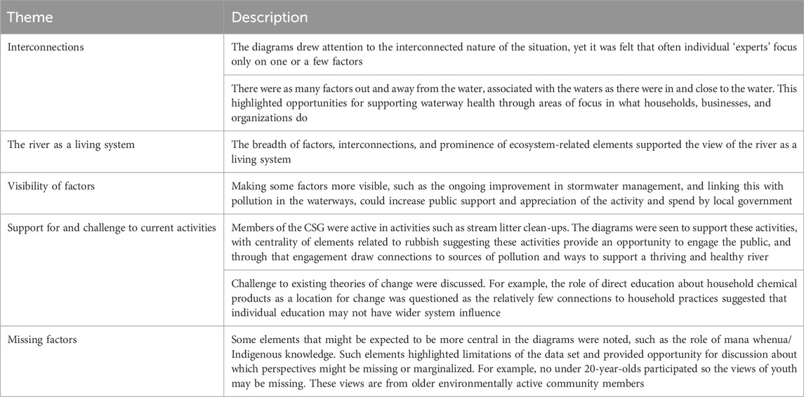
TABLE 3. Summary of insights identified by Community Steering Group (CSG).
5 Discussion
This case study focused on one highly polluted urban river estuary and catchment. The Whau river is the subject of two scientific projects designed to understand and mitigate the environmental impacts of microplastics and chemicals of emerging concern. Strong processes for co-design and working in partnership with the community, council and mana whenua groups were key to the research approach. A Community Steering Group was established and defined a key research objective as enhancing the ‘community’s capacity to act’ and focus on restoring the mauri, or health and spirit, of the river. Further objectives were to make visible the mana whenua history in the area and strengthen the community connections to the river. Although the complexity of this undertaking meant that all the outcomes were not fully achieved, especially as this was being conducted during the COVID-19 pandemic, the framework was considered robust and has continued after the project was officially finished. The inclusion of local council decision-makers in the CSG contributed to the sense that the collaboration could have impact on future policy and continued community environmental action in the area.
System Effects Mapping study was undertaken to support a shared understanding of community perspectives on the health of the river and to guide the CSG in its decision making. We now reflect on the past and potential future use of system diagrams in this context.
The CSG considered the diagram to be useful as it provided a systemic view that is often missed when groups focus on their own specific areas of interest. The system approach can support dialogue between the different partners and assist them to understand how different perspectives interact. Having an interactive diagram available on the project website and using the software to highlight and focus in on smaller, nested dynamics within the wider map was seen as especially helpful in supporting people to navigate complex information and have deeper conversation on where efforts might be best invested to produce the desired outcomes. The network diagram could be used to test assumptions about the influence of actions when developing a theory of change for new programs and interventions. The network diagram was shared on the community hosted project website alongside other research data from the wider project including Whau catchment pollution results. For future research engagements, interactive versions of the network diagram might be able to link more directly with other forms of mapping such as pollution results and show linkages to other local environmental programs and activities.
In this current research, the goal of taking a transdisciplinary and translational ecology approach to partnership between Indigenous, wider community, local government and researchers was realized, through regular and ongoing meetings, within which tools like the System Effects Mapping were used.
Dialogue and critical systems approaches have been identified as important for action on wicked issues (Walton and Baker, 2021). As a tool for supporting transdisciplinary dialogue in support of environmental action, the system effects network diagrams appeared to be useful. Of particular note was the dialogue around what was missing from the network diagram. For example, it was noted that the perspectives of youth and less environmentally aware groups were not represented and need to be included in future research. Including diverse perspectives within system diagrams supports shared understanding across different people’s mental models (Moon et al., 2019). While the intention in this study was to use System Effects Mapping in a qualitative way by generating a visual network diagram, with a larger number of respondents there is potential to utilize network statistics in supporting identification of particular factors as potential leverage points.
The online survey was shared through local government, mana whenua and environmental networks. We had anticipated higher numbers of responses and consider the online survey format may have limited the participation. However, difficulties faced in conducting field work within communities during the ongoing COVID-19 pandemic dictated the use of online media. The System Effects Mapping as originally developed was to be used in face-to-face collaborative workshops with key local stakeholders to support deeper questioning of the data and intervention planning. This serves as a timely reminder that all tools have limitations and should not be the only inputs, nor considered to be the sole source of ‘truth’. Being aware of which perspectives are included or excluded, and the boundaries these perspectives place around what is legitimate to consider in relation to any particular issue, is an important part of boundary critique. Boundary critique is a systems method which raises awareness of worldviews and judgements made on who is inside and outside the system studied (Midgley, 2000; Foote et al., 2020).
It has been noted that in western science ‘we can only manage what we can measure’ (Boucher and Billard, 2019). Although this critique does not necessarily apply in all contexts, it is undoubtedly helpful to better see, know, anticipate and model interactions and uncertainties in the design of effective points of intervention. Liboiron (2016, pp. 16–17) describes how representations of data can help to initiate action by resonating with pre-existing values and morals, and bringing together cultural and scientific aspects in pollution studies. Similar to developments in Indigenous theories of knowledge (Parsons et al., 2016; 2017), translational ecology (Enquist et al., 2017; Safford et al., 2017) and other social theories of change, systems effects mapping is helpful in supporting deeper boundary spanning work (Wyborn, 2015; Posner and Cvitanovic, 2019) for reflective, connective and relational work to orient the co-production of knowledge toward stronger interventions in complex ecological problems. Not only does System Effects Mapping help include and make explicit local place-based and experiential knowledge, it also makes important social and ecological linkages and relationships more visible, supporting knowledge synthesis and complex problem structuring.
System Effects Mapping in this project sat alongside other geospatial science such as modelling of connected harbor hydrology and water flow (Chen et al., 2022). The logic of continuing to remove litter from the land boundary of waterways that are connected to estuaries and harbors was also supported, despite sometimes seeming like an ‘ambulance at the bottom of the cliff’ approach. In context of understanding and supporting community capacity to act, the systems effects results confirmed the importance of litter clean-up and streamside restoration activities in helping restore community connections to the waterways. This shows that such activities have a deeper significance than might otherwise be assumed.
We concluded that Systems Effects Mapping was helpful in supporting collaborative sense-making and more complex problem structuring. The approach was useful in supporting local action and planning and assisted the research within the catchment to have more meaningful impacts for the local community. Systems Effects Mapping was utilized within a context where a collaborative community steering group had been established, and where the aims for the local project were co-produced using soft systems methodology tools. This group co-designed the systems effects study and this provided an important mechanism to prepare the group to make sense of and use the results. We acknowledge that resourcing to support this type of transdisciplinary collaboration may not always be feasible in science projects. However, if science is genuinely looking for meaningful impacts, resourcing community time for co-design and sense-making is essential for systems mapping approaches to usefully support capacity to act.
Data availability statement
The original contributions presented in the study are included in the article/Supplementary Material, further inquiries can be directed to the corresponding author.
Ethics statement
The studies involving humans were approved by Aotearoa Research Ethics Committee. The studies were conducted in accordance with the local legislation and institutional requirements. The participants provided their written informed consent to participate in this study.
Author contributions
VB: Conceptualization, Formal Analysis, Funding acquisition, Investigation, Methodology, Project administration, Supervision, Writing–original draft, Writing–review and editing. MW: Conceptualization, Formal Analysis, Investigation, Methodology, Project administration, Visualization, Writing–original draft, Writing–review and editing. SM: Conceptualization, Formal Analysis, Methodology, Project administration, Visualization, Writing–original draft, Writing–review and editing. JA: Conceptualization, Project administration, Writing–review and editing, Formal Analysis, Funding acquisition, Investigation, Methodology, Supervision, Writing–original draft. CG: Writing–review and editing, Conceptualization, Investigation, Project administration, Resources, Validation, Writing–original draft. RT-G: Conceptualization, Investigation, Project administration, Resources, Validation, Writing–original draft, Writing–review and editing.
Funding
The author(s) declare financial support was received for the research, authorship, and/or publication of this article. This research was conducted as part of the Aotearoa Impacts and Mitigation of Microplastics (AIM2) and Managing the Risk of Organic Contaminants (EOCs) projects in receipt of funds from New Zealand Ministry of Business, Innovation and Employment (MBIE) Endeavour Research Program grants C03X1802 and CAWX1708 respectively.
Acknowledgments
We thank our research partners in the Whau, West Auckland - Te Kawerau-ā-Maki (TKAM), Auckland Council and Ecomatters Environment Trust, the wider ECOs and AIM2 project team and Whau Community Steering Group, and people from the community who have participated in this research especially Hamish Allen, Rachel Ankeny, Heather Bray, Olga Pantos and Grant Northcott for comments and review. We also thank the New Zealand Ethics Committee (now the Aotearoa Research Ethics Committee) for their supportive review of the proposal and subsequent ethics approval.
Conflict of interest
The authors declare that the research was conducted in the absence of any commercial or financial relationships that could be construed as a potential conflict of interest.
Publisher’s note
All claims expressed in this article are solely those of the authors and do not necessarily represent those of their affiliated organizations, or those of the publisher, the editors and the reviewers. Any product that may be evaluated in this article, or claim that may be made by its manufacturer, is not guaranteed or endorsed by the publisher.
References
Ataria, J. M., Murphy, M., McGregor, D., Chiblow, S., Moggridge, B. J., Hikuroa, D. C. H., et al. (2023). Orienting the sustainable management of chemicals and waste toward indigenous knowledge. Environ. Sci. Technol. 57 (30), 10901–10903. doi:10.1021/acs.est.3c04600
Baker, V., Ataria, J., Ankeny, R., and Bray, H. (2023). Transdisciplinary science and the importance of Indigenous knowledge. Integr. Environ. Assess. Manag. n/a(n/a). doi:10.1002/ieam.4847
Bell, S., and Morse, S. (2013). How people use rich pictures to help them think and act. Syst. Pract. Action Res. 26 (4), 331–348. doi:10.1007/s11213-012-9236-x
Biedenweg, K., Trimbach, D., Delie, J., and Schwarz, B. (2020). Using cognitive mapping to understand conservation planning. Conserv. Biol. 34 (6), 1364–1372. doi:10.1111/cobi.13627
Boamah, E. F., Murshid, N. S., and Mozumder, M. G. N. (2021). A network understanding of FinTech (in)capabilities in the global South. Appl. Geogr. 135, 102538. doi:10.1016/j.apgeog.2021.102538
Boucher, J., and Billard, G. (2019). The challenges of measuring plastic pollution. Field Actions Sci. Rep. J. Field Actions 19, 68–75.
Brandt, P., Ernst, A., Gralla, F., Luederitz, C., Lang, D. J., Newig, J., et al. (2013). A review of transdisciplinary research in sustainability science. Ecol. Econ. 92, 1–15. doi:10.1016/j.ecolecon.2013.04.008
Brown, V. A., Harris, J. A., and Russell, J. Y. (2010). Tackling wicked problems through the transdisciplinary imagination. Earthscan. Oxford, UK.
Chapot, L., Nguyen-Tien, T., Pham-Thanh, L., Nguyen-Viet, H., Craven, L., and Lindahl, J. F. (2020). A mixed-methods approach to understanding knowledge of mosquito-borne infections and barriers for protection in hanoi, Vietnam. Trop. Med. Infect. Dis. 5 (2), 66. doi:10.3390/tropicalmed5020066
Checkland, P., and Poulter, J. (2010). “Soft systems methodology,” in Systems approaches to managing change: a practical guide. Editors M. Reynolds, and S. Holwell (Springer), Berlin, Germany, 191–242.
Chen, Z., Bowen, M., Li, G., Coco, G., and Hall, B. (2022). Retention and dispersion of buoyant plastic debris in a well-mixed estuary from drifter observations. Mar. Pollut. Bull. 180, 113793. doi:10.1016/j.marpolbul.2022.113793
Craven, L. K. (2017). System effects: a hybrid methodology for exploring the determinants of food in/security. Ann. Am. Assoc. Geogr. 107 (5), 1011–1027. doi:10.1080/24694452.2017.1309965
Davison, S. M. C., White, M. P., Pahl, S., Taylor, T., Fielding, K., Roberts, B. R., et al. (2021). Public concern about, and desire for research into, the human health effects of marine plastic pollution: results from a 15-country survey across Europe and Australia. Glob. Environ. Change-Human Policy Dimensions 69, 102309. doi:10.1016/j.gloenvcha.2021.102309
Drylie, T. P. (2021). Marine ecology state and trends in Tāmaki Makaurau / Auckland to 2019: state of the environment reporting. Auckland Council Technical Report. Available at: https://www.knowledgeauckland.org.nz/media/2018/tr2021-09-marine-ecology-state-and-trends-in-auckland-to-2019.pdf (Accessed September, 2021).
Enquist, C. A., Jackson, S. T., Garfin, G. M., Davis, F. W., Gerber, L. R., Littell, J. A., et al. (2017). Foundations of translational ecology. Front. Ecol. Environ. 15 (10), 541–550. doi:10.1002/fee.1733
Foote, J., Gregor, J., Hepi, M., Baker, V., Houston, D., and Midgley, G. (2007). Systemic problem structuring applied to community involvement in water conservation. J. Operational Res. Soc. 58 (5), 645–654. http://www.jstor.org/stable/4622741. doi:10.1057/palgrave.jors.2602248
Foote, J., Midgley, G., Ahuriri-Driscoll, A., Hepi, M., and Earl-Goulet, J. (2020). Systemic evaluation of community environmental management programmes. Eur. J. Operational Res. 288 (1), 207–224. doi:10.1016/j.ejor.2020.05.019
Goven, J., Langer, E. R. L., Baker, V., Ataria, J., and Leckie, A. (2015). A transdisciplinary approach to local waste management in New Zealand: addressing interrelated challenges through indigenous partnership. Futures 73, 22–36. doi:10.1016/j.futures.2015.07.011
Hayes, K., Blashki, G., Wiseman, J., Burke, S., and Reifels, L. (2018). Climate change and mental health: risks, impacts and priority actions. Int. J. Ment. Health Syst. 12 (1), 28. doi:10.1186/s13033-018-0210-6
Hepi, M., Foote, J., Makey, L., Badham, M., and Te Huna, A. (2018). Enabling mātauranga-informed management of the kaipara harbour, Aotearoa New Zealand. N. Z. J. Mar. Freshw. Res. 52 (4), 497–510. doi:10.1080/00288330.2018.1521845
Jahn, T., Bergmann, M., and Keil, F. (2012). Transdisciplinarity: between mainstreaming and marginalization. Ecol. Econ. 79, 1–10. doi:10.1016/j.ecolecon.2012.04.017
Kramm, J., Steinhoff, S., Werschmoller, S., Volker, B., and Volker, C. (2022). Explaining risk perception of microplastics: results from a representative survey in Germany. Glob. Environ. Change-Human Policy Dimensions 73, 102485. doi:10.1016/j.gloenvcha.2022.102485
Liboiron, M. (2016). Redefining pollution and action: the matter of plastics. J. material Cult. 21 (1), 87–110. doi:10.1177/1359183515622966
Lönngren, J., and Van Poeck, K. (2021). Wicked problems: a mapping review of the literature. Int. J. Sustain. Dev. World Ecol. 28 (6), 481–502. doi:10.1080/13504509.2020.1859415
Midgley, G. (2000). Systemic intervention: philosophy, methodology, and practice. New York, NY, USA: Springer.
Mills, G., and Allen, H. (2021). Marine sediment contaminant state and trends in Tāmaki Makaurau / Auckland 2004-2019: State of the environment reporting. Auckland Council Technical Report. Available at: https://knowledgeauckland.org.nz/media/2023/tr2021-10-marine-sediment-contaminant-state-and-trends-in-t%C4%81maki-makaurau-2004-to-2019.pdf (Accessed October, 2021).
Moon, K., Guerrero, A. M., Adams, V. M., Biggs, D., Blackman, D. A., Craven, L., et al. (2019). Mental models for conservation research and practice. Conserv. Lett. 12 (3), e12642. doi:10.1111/conl.12642
Parsons, M., Fisher, K., and Nalau, J. (2016). Alternative approaches to co-design: insights from indigenous/academic research collaborations. Curr. Opin. Environ. Sustain. 20, 99–105. doi:10.1016/j.cosust.2016.07.001
Parsons, M., Fisher, K., and Nalau, J. (2017). Alternative perspectives on sustainability: indigenous knowledge and methodologies. Challenges Sustain. 5 (1). http://www.librelloph.com/challengesinsustainability/article/view/cis-5.1.7. doi:10.12924/cis2017.05010007
Posner, S. M., and Cvitanovic, C. (2019). Evaluating the impacts of boundary-spanning activities at the interface of environmental science and policy: a review of progress and future research needs. Environ. Sci. Policy 92, 141–151. doi:10.1016/j.envsci.2018.11.006
Rittel, H. W. J., and Webber, M. M. (1973). Dilemmas in a general theory of planning. Policy Sci. 4 (2), 155–169. http://www.jstor.org/stable/4531523. doi:10.1007/bf01405730
Roesel, K., Craven, L., Chhay, T., Nguyen-Viet, H., and Grace, D. (2021). “Using system effects modelling to evaluate food safety impact and barriers in low-income-countries: an example from urban Cambodia,” in Poster prepared for the 15th International Symposium of Veterinary Epidemiology and Economics, Chiang Mai, Thailand, Nairobi, Kenya, November 2021.
Safford, H. D., Sawyer, S. C., Kocher, S. D., Hiers, J. K., and Cross, M. (2017). Linking knowledge to action: the role of boundary spanners in translating ecology. Front. Ecol. Environ. 15 (10), 560–568. doi:10.1002/fee.1731
Walton, M., and Baker, V. (2021). The role of evaluation in supporting action on a hazardous world, a call for critical-systems thinking. Eval. Matters 7, 148–157. doi:10.18296/em.0071
Wyborn, C. (2015). Connectivity conservation: boundary objects, science narratives and the co-production of science and practice. Environ. Sci. Policy 51, 292–303. doi:10.1016/j.envsci.2015.04.019
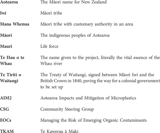
Glossary
Keywords: participatory action research, transdisciplinary, translational ecology, indigenous knowledge, community engagement, systems effects mapping
Citation: Baker V, Walton M, Manning S, Ataria J, Gee C and Taua-Gordon R (2024) System effects mapping: a tool for promoting collaborative community ecological action. Front. Environ. Sci. 12:1356065. doi: 10.3389/fenvs.2024.1356065
Received: 15 December 2023; Accepted: 30 January 2024;
Published: 09 February 2024.
Edited by:
James Kevin Summers, Office of Research and Development, United StatesReviewed by:
Rebecca Romsdahl, University of North Dakota, United StatesLinda Kay Silka, University of Maine, United States
Copyright © 2024 Baker, Walton, Manning, Ataria, Gee and Taua-Gordon. This is an open-access article distributed under the terms of the Creative Commons Attribution License (CC BY). The use, distribution or reproduction in other forums is permitted, provided the original author(s) and the copyright owner(s) are credited and that the original publication in this journal is cited, in accordance with accepted academic practice. No use, distribution or reproduction is permitted which does not comply with these terms.
*Correspondence: Suzanne Manning, Suzanne.Manning@esr.cri.nz