Decadal evolution of fluvial islands and its controlling factors along the lower Yangtze River
 Jingtao Wu
 Manman Fan1
  Muhammad Shaukat
- 1School of Geography and Planning, Huaiyin Normal University, Huaian, China
- 2School of Marine Science and Engineering, Nanjing Normal University, Nanjing, China
- 3Department of Agricultural Sciences, Allama Iqbal Open University, Islamabad, Pakistan
- 4Departments of Geology, Geography and GIS, Mechanical Science and Engineering and Ven Te Chow Hydrosystems Laboratory, University of Illinois at Urbana-Champaign, Urbana, IL, United States
- 5School of Environmental Science and Engineering, Yancheng Institute of Technology, Yancheng, China
- 6School of Geography and Ocean Science, Nanjing University, Nanjing, China
Fluvial islands are vital from both morphological and ecological perspectives and consequently have been hotspots of morphodynamic research in large rivers around the world. This study selected 14 representative fluvial islands in the lower reaches of the Yangtze River and explored their spatial-temporal evolution, including their shape and area dynamics during 1945–2016, by interpreting remote sensing images and analyzing the hydrological data. Results indicated that the total area of the 14 fluvial islands showed a growing trend at an average rate of 0.30 km2 yr−1 during the 72 years. The island Fenghuangzhou experienced the largest change in area, while Xiaohuangzhou (XHZ) had the smallest change in area. Sediment discharge and flooding were assumed to be the primary natural factors controlling the island dynamics. Furthermore, dam construction and bank reinforcement also played a critical role in preventing shoreline collapse, improving channel conditions, and promoting the stability of fluvial islands. From 1976 to 2016, the maximum erosion occurred on the left XHZ, while the maximum accretion was found on the Qingjiezhou island. Almost the entire river section experienced an accretion process on the right bank, which was assumed to be caused by the construction of erosion control structures. Besides, the dynamics of the fluvial islands along the lower Yangtze River appears to follow the erosion processes of the river bank. Our findings can provide an important reference for sustainable utilization and management of fluvial islands.
1 Introduction
Fluvial islands are formed and shaped by both sediment deposition and erosion (Baubiniené et al., 2015). Although fluvial islands are generally unstable and transient over various periods, they provide significant ecological functions such as maintaining well-defined banks and persisting long enough to allow the establishment of persistent vegetation (Osterkamp, 1998; Gurnell and Petts, 2002; Wyrick and Klingeman, 2011; Carling et al., 2014). Thus, fluvial islands are generally considered as indicators of both hydrological and biotic capacities, as well as health, of fluvial systems (Knighton and Nanson, 1993; Hooke and Yorke, 2011; Picco et al., 2014; Sun et al., 2018). Therefore, improving the understanding of the evolution of fluvial islands and their controls is a prerequisite to identifying strategies for sustainable utilization and management of fluvial islands, which is crucial for ensuring the long-term ecological health and resilience of fluvial islands.
Numerous researchers have studied the formation and sedimentary processes associated with transient fluvial islands (Zanoni et al., 2008; Wang and Xu, 2018; Zheng et al., 2019; Leli et al., 2020; Lou et al., 2022; do Amaral et al., 2023). Previous studies have examined various processes of fluvial islands, such as their migration and erosion, and found that these processes have an impact on banks, island bodies, and river channels (Promma et al., 2007; Wintenberger et al., 2015; Sudra et al., 2023). For example, Zanoni et al. (2008) examined the long-term evolution of island in a braided river and analyzed the effects of river flow regime and sediment delivery. Baubiniené et al. (2015) evaluated the changes of island number, area and location under the conditions of climate induced changes of river flow. Hoagland et al. (2024) modeled island evolution using the Lorenzo-Trueba and Mariotti model, which can simulate long-term changes in island system. Also, there are some studies that have been carried out on the channel evolution and maintenance and groundwater and surface water interactions of fluvial islands (Nelson and Sommers, 1983; McCabe et al., 2009; Roquero et al., 2015). The rationale for focusing on fluvial islands is that these islands are essential components of the riparian corridor, which strongly influences the geomorphic adjustment of rivers and floodplains (Singer and Aalto, 2009; Ollero et al., 2015; Bandyopadhyay et al., 2023). However, limited attention has been paid to the evolution of fluvial islands whose shape and size change appreciably with different fluvial processes, especially over decadal timescales.
The evolution of fluvial islands is affected by multiple natural factors of island development (Osterkamp, 1998; Gautier and Grivel, 2006) and anthropogenic factors such as engineering projects (Gao B. et al., 2013; Raška et al., 2017; Best, 2019). For example, Grove et al. (2013) found that floods exerted important influences on the morphological evolution of the fluvial system. Hudson et al. (2019) reported that sedimentary deposition directly prompted the formation of fluvial islands. Shi et al. (2018) showed that the key natural factor that influences island formation in the lower Yangtze River was sediment discharge. In addition, Gao C. et al. (2013) stated that there were no significant relationships between changes in the island area and natural factors, such as annual runoff and precipitation, and speculated that the construction of many large reservoirs could be the primary factor of change. The knowledge about the island dynamics and their driving factors allows the prediction of further fluvial process and the potential influence on the river regime. The present study is an attempt to contribute to the knowledge about fluvial islands based on a case study of the lower reaches in the Yangtze River.
This study reports on the island evolution in the Yangtze River, which is the third longest river in the world and the longest river in Asia, with its lower reaches being the most prosperous and populous area in China (Wu et al., 2020). Some fluvial islands are well-developed in the Anhui section of the lower Yangtze River and are vital for the stability of the Yangtze River. However, the sizes and shapes of these islands have changed rapidly due to rapid economic development since the launch of China’s reform and opening-up policies (Bai and Li, 2009; Sun et al., 2018). In particular, the construction of Three Gorges Dam (TGD), which is currently the largest hydroelectric complex in the world (Lou et al., 2018), affects the hydrological regime and dozens of fluvial islands in the lower reaches of the Yangtze River (Li et al., 2011; Xu et al., 2013; Chen et al., 2022). Therefore, the present study selected 14 fluvial islands in the lower reach of the Yangtze River due to their substantial size, well-defined shapes, and relatively stable morphological changes. This study investigated the evolution of fluvial islands and aimed to: 1) quantitatively document the morphological evolution of fluvial islands and 2) explore the possible driving factors that affect the evolution of fluvial islands.
2 Materials and methods
2.1 Study area
The Anhui section of the Yangtze River (Figure 1) lies in the south-central region of Anhui Province, China (29°34°–31°53N and 115°52°–118°50E), which is within the transition zone between a temperate and subtropical monsoon climate. The study area is 416 km long along the lower Yangtze River, in which fluvial islands were identified. The study period covers four decades and is subdivided into five time periods: 1976, 1986, 1996, 2006, and 2016. During the past 40 years, great changes have taken place in the lower Yangtze River, as it has adjusted to a variety of human impacts, especially the reduction of sediment discharge and channel engineering caused by dams, revetments, and meander bend cutoffs (Zhang et al., 2008; Luo et al., 2012; Liu et al., 2013; Chen et al., 2014; Yang et al., 2018).
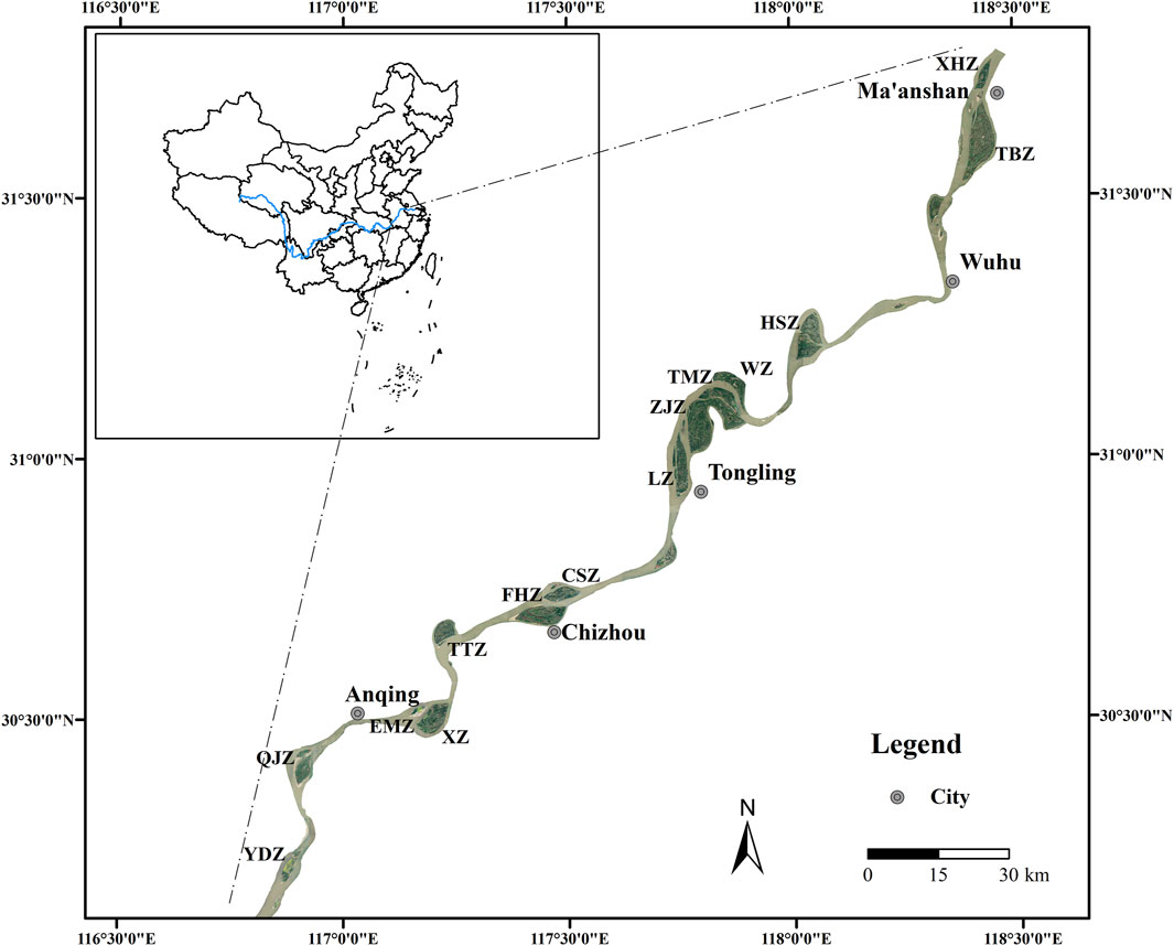
Figure 1. The Location of the study area and map of the fluvial islands in the study area, as derived from Landsat7/ETM+, acquired in December 2016.
The shape of islands has been divided previously into several categories: straight, micro-bend, and goose head branches (Chinese Academy of Sciences, 1985). The general characteristics and names of the 14 islands in the Anhui region (Figure 1) selected for the study are summarized in Table 1.
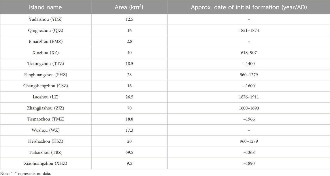
Table 1. Summary of the typical fluvial islands in the Anhui section of the lower Yangtze River.
2.2 Data acquisition
2.2.1 Aerial photographs and Landsat data
Multi-decadal Landsat data and scanned copies of aerial photographs were used to investigate the spatial-temporal evolution of these 14 fluvial islands. Aerial photographs taken in 1945 at a scale of 1:250,000, were obtained from the U.S. Army Map Service, Series L500 (https://www.utexas.edu/). Landsat MSS (Multispectral Scanner), Landsat TM (Thematic Mapper), and ETM+ (Enhanced Thematic Mapper) data from December 1976, 1986, 1996, 2006, and 2016, were acquired at 10-year intervals (Table 2), with cloud-free images being selected to enhance the clarity and richness of the image information. Furthermore, to minimize the effect of the water stage on interpreting the change in the size and shape of the fluvial islands, all Landsat images used were captured during the dry season of November and December when the discharge was considered constant within the channel in the study area. The Landsat dataset was acquired from the Geospatial Data Cloud (http://www.gscloud.cn).
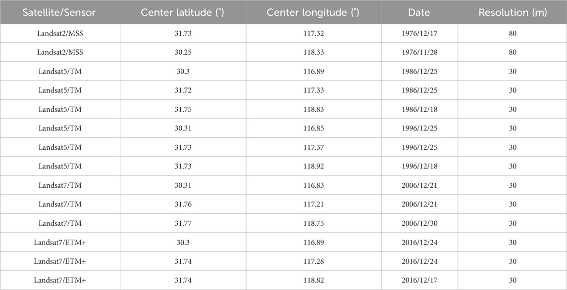
Table 2. Information about the Landsat images in the study.
2.2.2 Hydrological data
The annual runoff and sediment discharge data from 1950 to 2016 for the Datong hydrological station were obtained from the Changjiang Water Resources Committee (CWRC) (http://www.cjw.gov.cn/). Statistics indicate that from 1950 to 2016, the average annual runoff was 8,960 × 108 m3, and from 1950 to 2016, the average annual sediment discharge, average annual sediment concentration, and average sediment delivery were 3.63 × 10⁸ t, 0.414 kg m-3, and 216 t km-2, respectively. The maximum runoff of 13,590 × 108 m3 and minimum runoff of 6,671 × 108 m3 were recorded in 1954 and 2011, respectively. The highest sediment discharge was recorded at 6.78 × 10⁸ t in 1964, while the lowest sediment discharge was measured at 0.72 × 10⁸ t in 2011. In this study, the runoff and sediment discharge data at Datong Station from 1950 to 2016 were used to analyze the evolution of the islands and evaluate the uncertainties associated with changes in the area of the fluvial islands, as inferred from the interpretation of the remote sensing data.
2.3 Methods
2.3.1 Pre-processing of aerial and image photographs
Multiperiod Landsat data and scanned copies of aerial photographs were used to perform a spatial-temporal analysis of the fluvial islands over approximately a 72-year time series. Only permanent islands were selected in the study area (Figure 1). The aerial photographs were mosaiced and vectorized, and the bank lines were digitalized in ArcGIS 10.2 (ESRI Inc., United States).
To assess the variations in the land area of the fluvial island, a geometric correction process was applied to each satellite image. This involved transforming the images from the Universal Transverse Mercator (UTM) projection to the Albers Equal Area Conic projection, ensuring a uniform and accurate representation of the island’s topography for comparative analysis. To correct the resolution discrepancies between TM and MSS images, we employed a combination of band synthesis, region of interest (ROI) subsets, and resampling tools in ArcGIS 10.2. Using the near-infrared bands available in both TM and ETM+, we can effectively differentiate between water bodies and vegetation cover. Additionally, to ensure accuracy, we refine the image correction process by selecting the ground control point (GCP) using ENVI 5.1 (ITT Visual Information Solutions Inc., United States).
2.3.2 Methodology for extracting the change of fluvial islands
Using a suite of remote sensing image processing techniques, the morphology and area of the selected fluvial islands were delineated for the period from 1945 to 2016. To elucidate the trends in area change, the following equation was applied to compute anomalies for both individual island areas and the aggregate total area (see Eq. (1)).
where the term j refers to a specific fluvial island, i denotes a particular year,
Historical aerial photographs and remote sensing imagery from the years 1945, 1976, 1986, 1996, and 2016 were utilized to delineate the boundaries of the fluvial islands in the lower Yangtze River. All images were scanned at a resolution of 600 dpi and geo-rectified using ArcGIS 10.2. During the image rectification process, each photograph was resampled at a resolution of 0.5 m to ensure consistency across all images. Rectification resulted in a root mean square error of <5 m for all images.
Individual image frames and mapping tables were mosaicked in ENVI to obtain georeferenced images that cover the entire study area. The image stitching process is influenced by two sources of errors: distortion errors between adjacent frames and inherent errors of the orthoimages. When GCPs are combined in areas that overlap between adjacent frames, distortion caused by topographical variations is minimized, thereby reducing these errors to a minimum.
2.3.3 Quantitative analysis of bank erosion and deposition
The shoreline of the Yangtze River in Anhui Province, which stretches a straight-line distance of 250 km, was systematically divided into segments with equal intervals of 1 km. Cross sections were defined as perpendicular to the trend surface along the river segment. For this length, a 1 km interval is considered sufficient to characterize the morphological changes of the river channel within the study area. The displacement of both banks for each segment was determined using the methodology proposed by Kummu et al. (2008). Using GIS overlay analysis, the banklines of two periods were compared to quantify the displacement of each segment. Subsequently, the intersection points of the terminal lines of each end-member with the riverbank lines were calculated and their coordinates were compared to determine the variations in the riverbank line locations.
3 Results
3.1 Spatial-temporal variations of fluvial islands
3.1.1 Changes in the shape of fluvial islands
Remote sensing imagery and aerial photographs were used to extract the morphological characteristics of typical fluvial islands from different periods (Figure 2). As illustrated in Figure 2, the overall morphology of the fluvial islands appears relatively stable in the past 72 years. However, due to fluvial erosion and sediment deposition, some islands exhibit significant local changes. Specifically, HSZ and WZ have undergone erosion, while TMZ, FHZ, and YDZ have experienced significant sediment deposition. In the northern HSZ island, a diminutive island emerged around 1945. This island underwent a modest decrease in its expanse by approximately 1996 and ultimately integrated with the principal island by the year 2006. Concurrently, since 1966, a new island has been gradually accumulating at the northern edge of ZJZ, maturing into the more stable TMZ. Furthermore, WZ Island has been observed to exhibit convergence with the riverbank, while LZ and ZJZ have become morphologically stable.
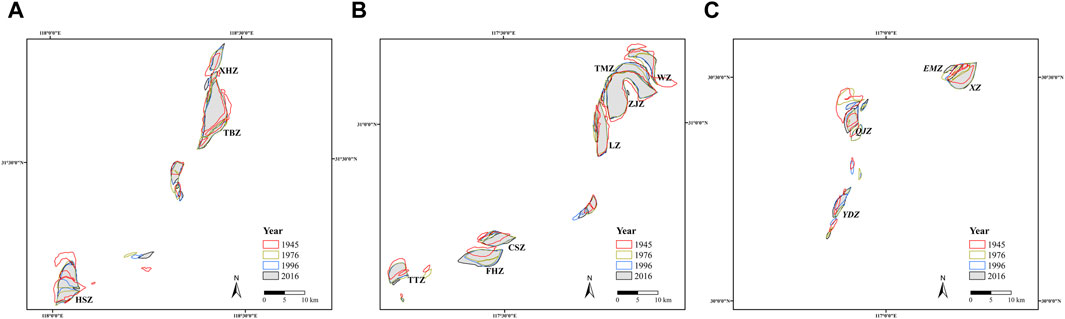
Figure 2. Area changes of the 14 fluvial islands in 1945, 1976, 1996, and 2016. The changes of islands HSZ, TBZ and XHZ were shown in (A), TTZ, FHZ, CSZ, LZ, ZJZ, TMZ, and WZ in (B) and YDZ, QJZ, XZ, and EMZ in (C).
3.1.2 Changes in the area of fluvial islands
The total area of the 14 selected fluvial islands experienced an expansion, growing from 373.3 km2 in 1945 to 394.9 km2 in 2016 (Figure 3A). Prior to 1986, the aggregate area of the islands witnessed a steady rise, with an average annual expansion of 0.32 km2 yr-1. In contrast, the period between 1986 and 1996 saw a swift decline in the total area, with an erosion rate of 1.5 km2 yr-1. Subsequently, post-1996, the total area resumed an upward trend at an average annual rate of 0.73 km2 yr-1.
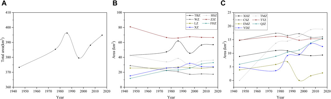
Figure 3. Changes in total area of the fluvial islands (km2) (A), and change in area of the individual island during 1945–2016 (B, C).
During the last 72 years, the average areas of individual islands can be ranked as follows: ZJZ > TBZ > HSZ > LZ > XZ > FHZ > WZ > CSZ > TTZ > TMZ > QJZ > XHZ > YDZ > EMZ (Figures 3B, C) with the areas of the 14 islands varying significantly before the 2000s and then remaining relatively stable after that. Specifically, the island ZJZ is the main island of Tongling City and the largest of the 14 islands, with an average area of 69.1 km2 and erosion that occurred during 1945–2016 (Figure 3B). The EMZ has the smallest area, with an average annual area of 3.5 km2 (Figure 3C). TBZ and XHZ were also observed to show similar tendencies, with an increase from 1945 (42.6 km2 and 8.8 km2, respectively) to 1986 (61.9 km2 and 10.9 km2, respectively) and then a substantial decrease from 1986 to 2006, followed by a slight growth of 0.2 km2 and 0.51 km2 from 2006 to 2016.
3.2 Trends in the evolution of fluvial islands
In order to explore the dynamics of the fluvial islands, the trends in the total area of the islands and the area of individual island were calculated. The data presented in Figure 4 indicate that the total area of the fluvial islands increased more rapidly between 1945 and 1986 and then slowed from 1986 to 2016. The total area of the fluvial islands demonstrated a general trend of expansion, with an annual average area of 386.3 km2 during the 72-year period, and with a steady average annual growth of 0.3 km2 yr-1.
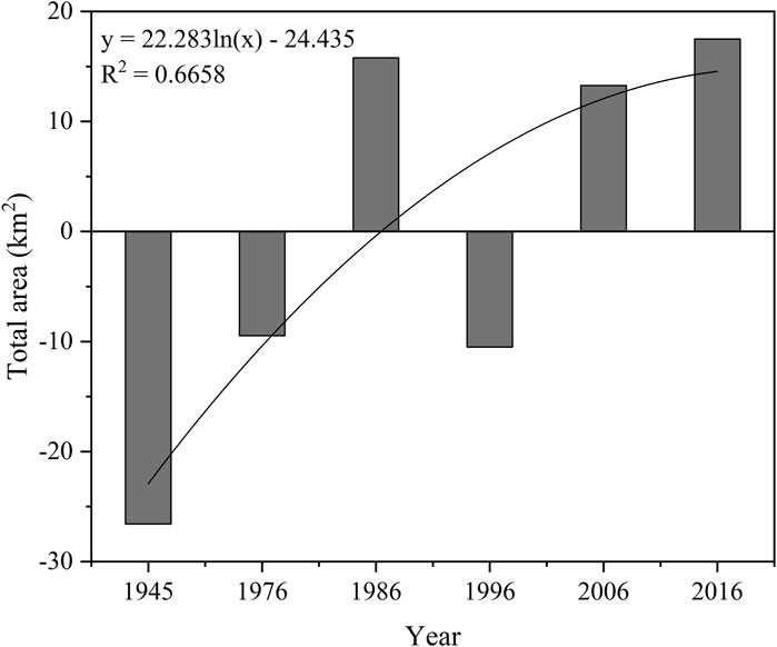
Figure 4. Trend in total area changes of the fluvial islands in the Anhui section of the Yangtze River from 1945 to 2016.
The annual average area change during the 72-year period was shown in Figures 5A, B. Most fluvial islands increased in area during 1945–2016, except for EMZ, HSZ, WZ, and ZJZ. The rate of increase in the island area varied significantly during the different periods. The FHZ, TMZ, and QJZ islands kept increasing in area from 1945 to 2016, with average growth rates of 0.29 km2 yr-1, 0.26 km2 yr-1, and 0.13 km2 yr-1, respectively. The island FHZ stand out as the fastest-growing, whereas ZJZ faced the most significant area reduction with an annual loss of 0.20 km2 yr-1. The area of XZ island initially expanded from 1945 to 1996, and then declined from 1996 to 2016. The island XHZ had the slightest area change with a minuscule decrease at a rate of 0.007 km2 yr-1. The island with a change in area change tending toward zero suggested a trend toward stability. The areas of islands WZ and ZJZ demonstrated a descending trend, which decreased faster from 1945 to 1996, but then increased at a relatively slower speed from 1996 to 2016.
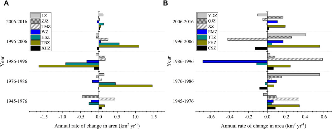
Figure 5. Annual area changes for islands LZ, ZJZ, TMZ, WZ, HSZ, TBZ and XHZ (A) and annual area changes for islands YDZ, QJZ, XZ, EMZ, TTZ, FHZ and CSZ (B).
3.3 Spatial pattern of bank erosion and deposition
Both the left and right banks of the lower Yangtze River experienced erosion and deposition during 1976–2016 (Figure 6). Specifically, the left bank of the lower Yangtze River has exhibited more accretion rather than erosion during the last 40 years. During this period, the maximum accretion occurred on the island QJZ and maximum erosion on the left bank of island XHZ. On the right bank, almost the full reach exhibited accretion.
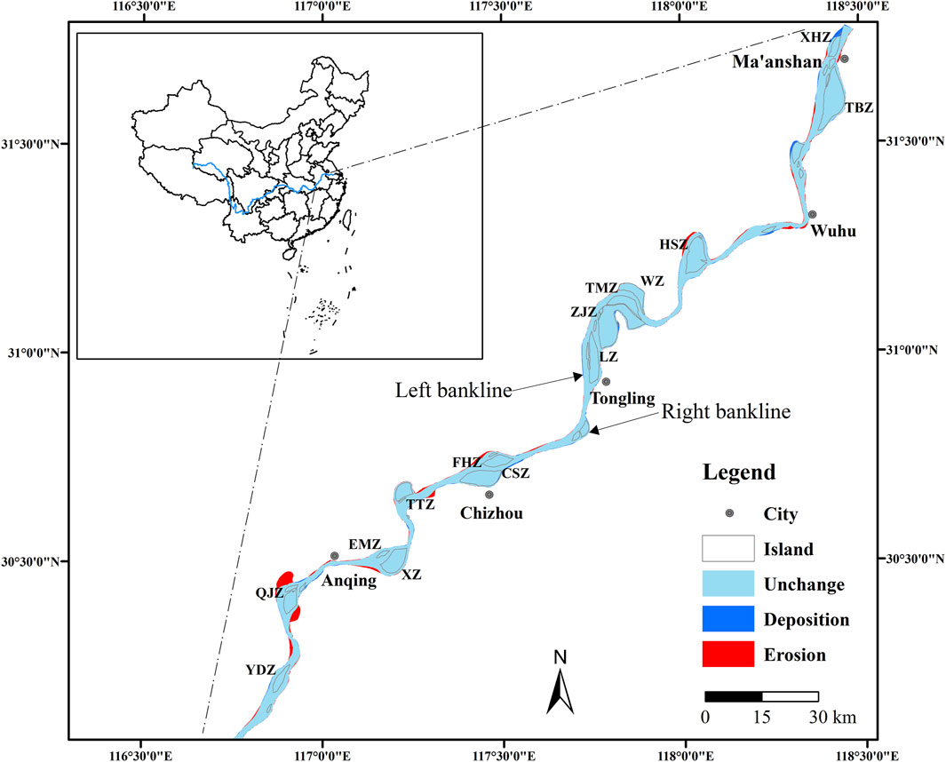
Figure 6. Spatial patterns of bank erosion and deposition along the lower Yangtze River between 1976 and 2016.
Figure 7 demonstrates a considerable movement of the bank lines resulting from accretion, indicating the movement of the banks in the river and the erosion, which depicts the movement of the banks in the land during 1976–2016. The bank line of 1976 is taken as reference, and the bank movement distances were calculated from the difference between the bank line of 1976 and the bank line of 2016 in ArcGIS. From the bank movement analysis during 1976–2016, the estimated maximum movement distances of erosion and deposition were approximately 3,500 m and 1,000 m, respectively, on the left bank, while the corresponding distances for the right bank were approximately 2,000 m and 800 m, respectively. Furthermore, the fluvial islands with an area larger than 20 km2, such as the islands ZJZ, HSZ and LZ (Figure 7), were generally stable, and the island change rates were close to 0 over time. However, the islands with an area of less than 20 km2, such as the islands YDZ and QJZ, were unstable during 1976–2016, with an area change rate of more than 0.15 km2 yr-1.
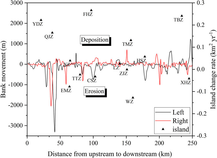
Figure 7. Bank movement along the lower Yangtze River for both the left and the right banks, and the island change rate between 1976 and 2016.
4 Discussion
4.1 Decadal evolution of fluvial islands
By comparing Landsat MSS, TM, and ETM + images from 1945 to 2016, changes in the shapes of islands in the lower Yangtze River were clearly visible. The spatial pattern of the morphologic changes varied between the different islands due to differences in their erosion and deposition processes. Overall, the total areas of these fluvial islands increased from 1945 to 2016. Smaller islands, such as XHZ and YDZ, have undergone notable morphological transformations, characterized by erosion at the island’s head and accretion at the tail, leading to a downstream extension of the island body. This conforms with the fact that the island head is typically subjected to erosion due to the impact of larger water flows, followed by a decrease in hydrodynamics as the water divides, resulting in sediment accumulation at the island’s tail (Hooke and Yorke, 2011). Mapping from the four images also indicated that the positions of the fluvial islands had shifted slightly during that development, with a general pattern of erosion on the left margin and sedimentation on the right. Previous studies have speculated that the changes on the left margin of fluvial islands are due to waves generated by vessels that navigate the left channel, which intensify erosion. On the contrary, the right margin has shown a more stable development with a higher degree of soil maturation (Zheng et al., 2018).
The larger fluvial islands, such as ZJZ and TBZ, which covered the largest area among all the fluvial islands, showed slight changes in their shapes during the past 72 years. The island ZJZ, located near the central area of Tongling City, stretches approximately 11.8 km in length and reaches a maximum width of 2.7 km (Figure 1). In this section of the Yangtze River, a relatively straight braided channel has formed, with the left channel serving as the main channel, contributing up to 95% of the water and 96% of the sediment to the main channel. The flow velocities along the course of TBZ and ZJZ are nearly identical, averaging about 46,000 m3 s-1 (Gao, 2012). The island TBZ, located to the south of Maanshan City in the middle part of the lower Yangtze River, runs southwest to northeast. The island TBZ has a length of 17.6 km and a maximum width of 5.6 km (Figure 1), which was formed by sediment erosion and deposition with its current contour having taken form during the Song Dynasty (Shi et al., 2017). The Yangtze River exhibits a straight two-channel anabranching form. Since 1860, the river has been bifurcated by TBZ into a left and right channel, with the left channel being the main one. This channel contributes a significant proportion of the water and sediment to the main channel, with the water and sediment contributions reaching up to 89% and 92%, respectively (Liu et al., 2016).
4.2 Factors controlling the dynamics of fluvial islands
4.2.1 Natural factors
As presented in Figure 8, the annual runoff at Datong Station did not show an obvious trend, except that the annual runoff for the years 1954 and 1998 was much higher than that in other years. However, the annual sediment discharge experienced a notable decline post-1986 (Figure 8), which had a significant impact on the sedimentary input and the total area of fluvial islands (Figure 3A), thereby affecting the formation and stability of the fluvial islands. This trend suggests that there was an insufficient sediment supply to support the expansion of the islands. Previous studies have found that natural factors such as runoff and sediment discharge play an important role in the evolution of fluvial islands or deltas in large rivers (Baki and Gan, 2012; Ve et al., 2021; Quang et al., 2023). The annual migration rate of high sediment concentration rivers is higher than that of low sediment concentration rivers, due to the rapid growth and migration of the bars that force bank erosion (Constantine et al., 2014). The average annual sediment discharge was 3.63 × 10⁸ t and decreased drastically after the construction of the TGD. The area of the 14 islands tended to decrease with the decrease in sediment content, while increasing the sediment content. This coincides with the findings of Li et al. (2019), and similar phenomena have been observed in the channel bars in the middle Yangtze River. River sediment discharge is usually considered one of the major factors controlling island dynamics (Moretto et al., 2014). In this study, it is inferred that sediment discharge is the primary factor responsible for the observed reduction in the area of the fluvial islands.
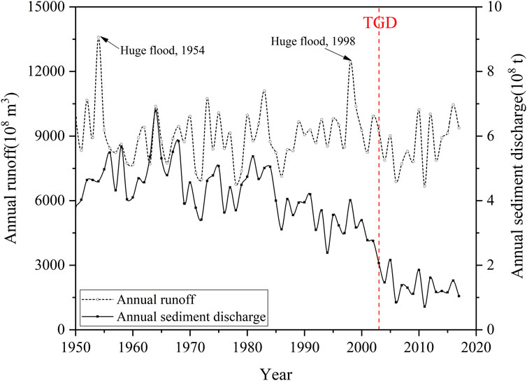
Figure 8. Annual runoff and sediment discharge of Datong hydrological station from 1950 to 2016.
Flooding is also considered a significant factor that causes morphological changes in fluvial islands (Asaeda and Rashid, 2012). Within the time span from 1945 to 2016, there were two historic crests. The data presented in Figure 8 also show that annual runoff and sediment discharge reached a relatively high level, while the total area of the fluvial islands decreased to the lowest in 1954 and 1998. In 1954, a huge flood occurred with the water stage reaching 16.6 m and a maximum flow of 92,600 m3 s-1 at Datong Station. In 1998, another catastrophic flood occurred with a maximum flow of 81,000 m3 s-1 (CWRC). The flood in 1998 reduced the total area to its lowest area after 1950. Bertoldi et al. (2009) also observed similar phenomena in their study of the Tagliamento River, a braided river where water flow and sediment transport are largely uncontrolled, with extreme floods being a major cause of erosion on fluvial islands. Annual runoff also influences the flow velocity along the fluvial islands, with the river segments of the study area exhibiting relatively stable flow velocities. It was observed that narrower stretches of the river exhibit higher velocities compared to wider ones and that velocities are higher upstream than downstream. Consequently, fluvial islands situated in regions with higher velocities, such as EMZ and HSZ, experienced more erosion (Moretto et al., 2012).
The evolution of fluvial islands is the result of long-term interactions between river boundaries and sediment transport (Shi et al., 2017). In this case, the evolution of fluvial islands in the lower reaches will be affected by riverbank erosion and deposition. The left bank shows more deposition than erosion, while almost all sections of the right bank show deposition. This may be due to the fact that a large number of shore protection projects effectively prevent shore erosion. The area with the largest erosion distance on both banks happens to be along with the merging of fluvial islands, and a similar island merging phenomenon also occurs in the Zhen-Yang reach of the Yangtze River (Yang, 2020). Fluvial islands with large morphological changes are found around the bank with evident displacement, suggesting that the evolution of fluvial islands in the Anhui section of the Yangtze River may be closely related to the erosion and deposition process on both banks of the Yangtze River. Comparing this study with the findings of Baki and Gan (2012) and Hudson et al. (2019), we suggest that the riverbank migration plays an important role in the island dynamics. Specifically, in this study area, the narrowing of the river channel will hinder the development of fluvial islands, while the widening of the river channel will promote the silting and growth of fluvial islands. Further investigations should be carried out to detail this point in the future.
The evolution of fluvial islands is also influenced by other natural factors, such as precipitation, vegetation cover, and vegetation types (Baubiniené et al., 2015). In the present study, the area changes of ZJZ and TBZ are relatively minor, and they are situated under similar hydro-sedimentary conditions. However, they have experienced different erosion and deposition processes, which is hypothesized to be due to the overflow of water from the lakes within the fluvial islands during the rainy season, leading to the loss of soil and shallow banks after the river scavenging. Furthermore, the higher the vegetation coverage and the richer the vegetation types, the less soil erosion on the island. Among them, trees are superior to shrubs and grasses, mixed forests are better than single-species forests, and the dense reeds along the outer edge of the island also serve as natural flood barriers. Short shrubs and trees that grow in the floodplain can also play a good role in stabilizing the embankment (Corenblit et al., 2015). In a study on channel bar morphodynamics in the middle Yangtze River, Wang et al. (2018) reported that the bars with high vegetation coverage tend to be stable during floods, while the bars with less vegetation are prone erosion. It can be seen that the vegetation can enhance the anti-erosion ability and thus promote the stability of fluvial islands.
4.2.2 Human factors
With the development of the social economy, anthropogenic influences play an increasingly significant role in the evolution of fluvial islands (Luan et al., 2018; Yang et al., 2018). Due to overexploitation and unreasonable land use, bank collapse often occurs. The evolution of the fluvial islands within the lower Yangtze River is also related to anthropogenic engineering and planning. The construction of the dams, the submerged banks, bank reinforcements, as well as guard works, have been significant factors in preventing shoreline collapse, improving the channel conditions, and stabilizing the branching pattern. These projects have weakened the scouring in the channel and protected the river channels and dikes along the two banks (Hudson et al., 2019).
In the lower reaches of the Yangtze River, the significant reduction in sediment discharge and external material input, which are necessary for the development of islands, is closely related to the construction of the TGD (Shi et al., 2017). As reported by Chen et al. (2016), the construction of over 50,000 reservoirs in the Yangtze River basin since the 1950s has had a minimal effect on the annual runoff, yet the seasonal fluctuations in dam storage could influence the monthly distribution of runoff. The completion of the TGD has been associated with a notable reduction in the annual volume of sediment transport, serving as a compelling indicator of the significant impact of human activities on sediment dynamics (Zhao et al., 2017). Typically, the increasing runoff correlates with the increasing scouring, leading to a decrease in the area of fluvial islands due to erosion. However, since 2006, the total area of these islands has paradoxically expanded along with the annual runoff (Figures 3, 8). This trend could be attributed to the government’s initiatives to reinforce the embankment system along the Anhui section of the Yangtze River, which has mitigated island erosion and facilitated ongoing sediment deposition.
Previous studies have revealed that ongoing enhancement of embankment systems has been instrumental in mitigating erosion and submersion of fluvial islands by river waters, fostering their stable development and progressive accretion, which in turn has led to a gradual expansion of their surface areas (Hudson et al., 2019). Following the completion of the TGD, both the individual and cumulative areas of the fluvial islands exhibited a slow growth. This indicates that the significant decrease in sediment supply from upstream, has hindered the expansion of these islands due to the construction of the TGD (Li et al., 2016). Additionally, the dam has exacerbated the scouring effects during periods of high water, further eroding the islands and impeding their sedimentation and expansion. This process has also been observed to induce changes in the morphology of the fluvial islands (Luan et al., 2018).
Human activities such as sand mining, reforestation, and water regulation projects have a profound impact on the development of fluvial islands (Gurnell et al., 2005). Since the end of the last century, the evolution of these islands in the Lower Yangtze River has been notably influenced by human interventions. Practices such as riverbed dredging have incised the riverbed, leading to deeper and narrower channels, which in turn affect the morphological development of the fluvial islands (Lou et al., 2018). Previous studies have demonstrated that the fluctuation in the area of the fluvial islands of Yangtze River is a direct result of changes in the hydrological and sedimentary regimes. Sand and gravel extraction can fragment the riverbed, fostering vegetation growth and accelerating the amalgamation of fluvial islands (Moretto et al., 2012). Afforestation efforts on these islands, coupled with increased vegetation cover, have a stabilizing effect on the riverbanks and the islands, thus influencing the dynamics of sediment transport. This intervention limits erosion and channel migration, leading to channel incision and enhanced stability of the fluvial islands. These anthropogenic influences indirectly modify the distribution of water flow and can even alter the main distributaries, thereby affecting the conditions of exogenous material for the formation of fluvial islands.
Furthermore, the formation and evolution of fluvial islands not only influence their morphology, area, and direction of their development, but also profoundly influence their geochemical characteristics and regional variations. The age of island formation is correlated with the degree of soil development and the extent of soil utilization, which, in turn, markedly affects the accumulation and migration patterns of the physicochemical properties and elements of the soil (including the major and trace elements). This inevitably impacts their geochemical characteristics and regional differences. In contrast, variations in land use and soil properties also indirectly reflect the surface processes within the watershed, to some extent affecting the stability of the morphology of the fluvial islands. The interplay between these factors and their implications for the morphology and geochemistry of fluvial islands remains an area that is ready for further investigation.
5 Conclusion
This study analyzed the spatiotemporal evolution of fluvial islands and their influencing factors during 1945–2016 in the lower Yangtze River, based on historical aerial photographs and Landsat MSS, TM, and ETM + data. During the past 72 years, the total area of the 14 fluvial islands showed a general increase at an average rate of 0.30 km2 yr-1. The island FHZ experienced the largest change in area, while XHZ had the smallest change in area. Sediment discharge and flooding were assumed to be the most significant natural factors controlling island dynamics. Additionally, the construction of dams and bank reinforcement also played a critical role in preventing shoreline collapse, improving channel conditions, and promoting the stability of the fluvial islands. From 1976 to 2016, the maximum accretion occurred on the island QJZ and the maximum erosion occurred on the left bank of island XHZ. On the right bank, almost the full reach exhibited accretion, which could be due to the erosion control structures that were built. The dynamics of the fluvial islands along the lower Yangtze River seems to follow the river bank erosion processes. The results of this study can provide an important reference for decision-making of sustainable island utilization and management. Further work is still necessary to quantify the relationship between island evolution and riverbank movement.
Data availability statement
The original contributions presented in the study are included in the article/Supplementary material, further inquiries can be directed to the corresponding author.
Author contributions
JW: Conceptualization, Data curation, Formal Analysis, Funding acquisition, Writing–original draft. MF: Formal Analysis, Funding acquisition, Writing–original draft. HZ: Writing–review and editing. MS: Writing–review and editing. JB: Conceptualization, Methodology, Writing–review and editing. NL: Writing–review and editing. CG: Conceptualization, Funding acquisition, Methodology, Supervision, Writing–review and editing.
Funding
The author(s) declare that financial support was received for the research, authorship, and/or publication of this article. This research was supported by the National Natural Science Foundation of China (Grant No: 41877002 and 42101062) and the Natural Science Foundation of the Jiangsu Higher Education Institutions of China (Grant No: 22KJB170008).
Conflict of interest
The authors declare that the research was conducted in the absence of any commercial or financial relationships that could be construed as a potential conflict of interest.
Publisher’s note
All claims expressed in this article are solely those of the authors and do not necessarily represent those of their affiliated organizations, or those of the publisher, the editors and the reviewers. Any product that may be evaluated in this article, or claim that may be made by its manufacturer, is not guaranteed or endorsed by the publisher.
References
Asaeda, T., and Rashid, M. H. (2012). The impacts of sediment released from dams on downstream sediment bar vegetation. J. Hydrol. 430, 25–38. doi:10.1016/j.jhydrol.2012.01.040
Baki, A. B. M., and Gan, T. Y. (2012). Riverbank migration and island dynamics of the braided Jamuna River of the Ganges-Brahmaputra basin using multi-temporal Landsat images. Quatern. Int. 263, 148–161. doi:10.1016/j.quaint.2012.03.016
Bandyopadhyay, S., Kar, N. S., Dasgupta, S., Mukherjee, D., and Das, A. (2023). Island area changes in the sundarban region of the abandoned western ganga–brahmaputra–meghna delta, India and Bangladesh. Geomorphology 422, 108482. doi:10.1016/j.geomorph.2022.108482
Baubiniené, A., Satkunas, J., and Taminskas, J. (2015). Formation of fluvial islands and its determining factors, case study of the River Neris, the Baltic Sea basin. Geomorphology 231, 343–352. doi:10.1016/j.geomorph.2014.12.025
Bertoldi, W., Gurnell, A. M., Surian, N., Tockner, K., Ziliani, L., Zolezzi, G., et al. (2009). Understanding reference processes: linkages between river flows, sediment dynamics and vegetated landforms along the Tagliamento River, Italy. Italy. River Res. Appl. 25, 501–516. doi:10.1002/rra.1233
Best, J. (2019). Anthropogenic stresses on the world’s big rivers. Nat. Geosci. 12, 7–21. doi:10.1038/s41561-018-0262-x
Carling, P., Jansen, J., and Meshkova, L. (2014). Multichannel rivers: their definition and classification. Earth Surf. Proc. Land. 39 (1), 26–37. doi:10.1002/esp.3419
Chen, J., Finlayson, B. L., Wei, T., Sun, Q., Webber, M., Li, M., et al. (2016). Changes in monthly flows in the Yangtze River, China-with special reference to the three Gorges dam. J. Hydrol. 536, 293–301. doi:10.1016/j.jhydrol.2016.03.008
Chen, J., Wu, X., Finlayson, B. L., Webber, M., Wei, T., Li, M., et al. (2014). Variability and trend in the hydrology of the Yangtze River, China: annual precipitation and runoff. J. Hydrol. 513, 403–412. doi:10.1016/j.jhydrol.2014.03.044
Chen, Z., Xu, K., and Watanabe, M. (2022). “Dynamic hydrology and geomorphology of the Yangtze River,” in Large rivers: geomorphology manage. Second Edition (Wiley), 687–703. doi:10.1002/9781119412632.ch23
Chinese Academy of Sciences (1985). Chinese natural geography” committee. General introduction to Chinese natural geography. Beijing, China: Chinese Academy of Sciences Press. (in Chinese).
Constantine, J. A., Dunne, T., Ahmed, J., Legleiter, C., and Lazarus, E. D. (2014). Sediment supply as a driver of river meandering and floodplain evolution in the Amazon Basin. Nat. Geosci. 7, 899–903. doi:10.1038/ngeo2282
Corenblit, D., Davies, N. S., Steiger, J., Gibling, M. R., and Bornette, G. (2015). Considering river structure and stability in the light of evolution: feedbacks between riparian vegetation and hydrogeomorphology. Earth Surf. Proc. Land. 40 (2), 189–207. doi:10.1002/esp.3643
do Amaral, D. D., de Fátima Rossetti, D., Gurgel, E. S. C., and Pereira, J. L. G. (2023). Phytophysiognomy in the east of the Marajó island (mouth of the Amazon River) from the perspective of geological history in the Late Quaternary. Catena 220, 106711. doi:10.1016/j.catena.2022.106711
Gao, B., Yang, D., and Yang, H. (2013a). Impact of the three Gorges dam on flow regime in the middle and lower Yangtze River. Quatern. Int. 304, 43–50. doi:10.1016/j.quaint.2012.11.023
Gao, C. (2012). Study on channel islands in Ma-Wu-tong section of Yangtze River based on MSS/TM/ETM remote sensing image. Remote Sens. Technol. Appl. 27 (1), 135–141. doi:10.11873/j.issn.1004-0323.2012.1.135
Gao, C., Chen, S., and Yu, J. (2013b). River islands’ change and impacting factors in the lower reaches of the Yangtze River based on remote sensing. Quatern. Int. 304, 13–21. doi:10.1016/j.quaint.2013.03.001
Gautier, E., and Grivel, S. (2006). “Multi-scale analysis of island formation and development in the Middle Loire River, France,” in Proceedings of symposium (Dundee, United Kingdom: Sediment dynamics and the hydromorphology of fluvial systems), 179–187. AIAHS Pub. 306.
Grove, J. R., Croke, J. C., and Thompson, C. J. (2013). Quantifying different riverbank erosion processes during an extreme flood event. Earth Surf. Proc. Land. 38 (12), 1393–1406. doi:10.1002/esp.3386
Gurnell, A., Tockner, K., Edwards, P., and Petts, G. (2005). Effects of deposited wood on biocomplexity of river corridors. Front. Ecol. Environ. 3 (7), 377–382. doi:10.1890/1540-9295(2005)003[0377:EODWOB]2.0.CO;2
Gurnell, A. M., and Petts, G. E. (2002). Island-dominated landscapes of large floodplain rivers, a European perspective. Freshw. Biol. 47 (4), 581–600. doi:10.1046/j.1365-2427.2002.00923.x
Hoagland, S. W., Irish, J. L., and Weiss, R. (2024). Morphodynamic and modeling insights from global sensitivity analysis of a barrier island evolution model. Geomorphology 451, 109087. doi:10.1016/j.geomorph.2024.109087
Hooke, J. M., and Yorke, L. (2011). Channel bar dynamics on multi-decadal timescales in an active meandering river. Earth Surf. Proc. Land. 36 (14), 1910–1928. doi:10.1002/esp.2214
Hudson, P. F., van der Hout, E., and Verdaasdonk, M. (2019). (Re) Development of fluvial islands along the lower Mississippi River over five decades, 1965–2015. Geomorphology 331, 78–91. doi:10.1016/j.geomorph.2018.11.005
Knighton, A. D., and Nanson, G. C. (1993). Anastomosis and the continuum of channel pattern. Earth Surf. Proc. Land. 18 (7), 613–625. doi:10.1002/esp.3290180705
Kummu, M., Lu, X. X., Rasphone, A., Sarkkula, J., and Koponen, J. (2008). Riverbank changes along the Mekong River: remote sensing detection in the Vientiane-Nong Khai area. Quatern. Int. 186 (1), 100–112. doi:10.1016/j.quaint.2007.10.015
Leli, I. T., Stevaux, J. C., and Assine, M. L. (2020). Origin, evolution, and sedimentary records of islands in large anabranching tropical rivers: the case of the Upper Paraná River, Brazil. Geomorphology 358, 107118. doi:10.1016/j.geomorph.2020.107118
Li, D. F., Lu, X. X., Chen, L., and Wasson, R. J. (2019). Downstream geomorphic impact of the three Gorges dam: with special reference to the channel bars in the middle Yangtze River. Earth Sur. Process. Landforms 44 (13), 2660–2670. doi:10.1002/esp.4691
Li, Q., Yu, M., Lu, G., Cai, T., Bai, X., and Xia, Z. (2011). Impacts of the gezhouba and three Gorges reservoirs on the sediment regime in the Yangtze River, China. J. Hydrol. 403 (3–4), 224–233. doi:10.1016/j.jhydrol.2011.03.043
Li, X., Liu, J. P., and Tian, B. (2016). Evolution of the Jiuduansha wetland and the impact of navigation works in the Yangtze Estuary, China. Geomorphology 253, 328–339. doi:10.1016/j.geomorph.2015.10.031
Liu, J., Zang, C., Tian, S., Liu, J., Yang, H., Jia, S., et al. (2013). Water conservancy projects in China: achievements, challenges and way forward. Glob. Environ. Chang. 23 (3), 633–643. doi:10.1016/j.gloenvcha.2013.02.002
Liu, X., Huang, H. Q., and Nanson, G. C. (2016). The morphometric variation of islands in the middle and lower Yangtze River: a variational analytical explanation. Geomorphology 261, 273–281. doi:10.1016/j.geomorph.2016.03.004
Lou, Y., Dai, Z., Lu, X., and Li, D. (2022). Anthropogenic pressures induced hydromorphodynamic changes of riverine islands in the upper Jingjiang reach along the Changjiang (Yangtze) river. Catena 217, 106488. doi:10.1016/j.catena.2022.106488
Lou, Y., Mei, X., Dai, Z., Wang, J., and Wei, W. (2018). Evolution of the mid-channel bars in the middle and lower reaches of the Changjiang (Yangtze) River from 1989 to 2014 based on the Landsat satellite images: impact of the Three Gorges Dam. Environ. Earth Sci. 77 (10), 394. doi:10.1007/s12665-018-7576-2
Luan, H. L., Ding, P. X., Wang, Z. B., Yang, S. L., and Lu, J. Y. (2018). Morphodynamic impacts of large-scale engineering projects in the Yangtze River delta. Coast. Eng. 141, 1–11. doi:10.1016/j.coastaleng.2018.08.013
Luo, X. X., Yang, S. L., and Zhang, J. (2012). The impact of the Three Gorges Dam on the downstream distribution and texture of sediments along the middle and lower Yangtze River (Changjiang) and its estuary, and subsequent sediment dispersal in the East China Sea. Geomorphology 179, 126–140. doi:10.1016/j.geomorph.2012.05.034
McCabe, R. M., MacCready, P., and Hickey, B. M. (2009). Ebb-tide dynamics and spreading of a large river plume. J. Phys. Oceanogr. 39 (11), 2839–2856. doi:10.1175/2009JPO4061.1
Moretto, J., Rigon, E., Mao, L., Picco, L., Delai, F., and Lenzi, M. A. (2012). Medium-and short-term channel and island evolution in a disturbed gravel bed river (Brenta River, Italy). J. Agr. Eng. 43 (4), 27–7. doi:10.4081/jae.2012.e27
Moretto, J., Rigon, E. L. L. F., Mao, L., Picco, L., Delai, F., and Lenzi, M. A. (2014). Channel adjustments and island dynamics in the Brenta River (Italy) over the last 30 years. River Res. Appl. 30 (6), 719–732. doi:10.1002/rra.2676
Nelson, D. W., and Sommers, L. E. (1983). Total carbon, organic carbon, and organic matter. Methods soil analysis 9, 539–579. doi:10.2134/agronmonogr9.2.2ed.c29
Ollero, A., Ibisate, A., Granado, D., and Asua, R. R. D. (2015). “Channel responses to global change and local impacts: perspectives and tools for floodplain management, Ebro river and Tributaries, NE Spain,” in Geomorphic approaches to integrated floodplain management of lowland fluvial systems in North America and Europe (New York, NY: Springer), 27–52. doi:10.1007/978-1-4939-2380-9_3
Osterkamp, W. R. (1998). Processes of fluvial island formation, with examples from plum creek, Colorado and snake river, Idaho. Wetlands 18 (4), 530–545. doi:10.1007/BF03161670
Picco, L., Mao, L., Rainato, R., and Lenzi, M. A. (2014). Medium-term fluvial island evolution in a disturbed gravel-bed river (Piave River, Northeastern Italian Alps). Geogr. Ann. A 96 (1), 83–97. doi:10.1111/geoa.12034
Promma, K., Zheng, C., and Asnachinda, P. (2007). Groundwater and surface-water interactions in a confined alluvial aquifer between two rivers: effects of groundwater flow dynamics on high iron anomaly. Hydrogeol. J. 15 (3), 495–513. doi:10.1007/s10040-006-0110-8
Quang, N. H., Thang, H. N., An, N. V., and Luan, N. T. (2023). Delta lobe development in response to changing fluvial sediment supply by the second largest river in Vietnam. Catena 231, 107314. doi:10.1016/j.catena.2023.107314
Raška, P., Dolejš, M., and Hofmanová, M. (2017). Effects of damming on long-term development of fluvial islands, Elbe River (N Czechia). River Res. Appl. 33 (4), 471–482. doi:10.1002/rra.3104
Roquero, E., Silva, P. G., Goy, J. L., Zazo, C., and Massana, J. (2015). Soil evolution indices in fluvial terrace chronosequences from central Spain (Tagus and Duero fluvial basins). Quatern. Int. 376, 101–113. doi:10.1016/j.quaint.2014.11.036
Shi, H., Cao, Y., Dong, C., Xia, C., and Li, C. (2018). The Spatio-Temporal Evolution of river island based on Landsat Satellite Imagery, hydrodynamic numerical simulation and observed data. Remote Sens. 10 (12), 2046. doi:10.3390/rs10122046
Shi, H., Gao, C., Dong, C., Xia, C., and Xu, G. (2017). Variation of river islands around a large city along the Yangtze River from satellite remote sensing images. Sensors 17 (10), 2213. doi:10.3390/s17102213
Singer, M. B., and Aalto, R. (2009). Floodplain development in an engineered setting. Earth Surf. Proc. Land. 34 (2), 291–304. doi:10.1002/esp.1725
Sudra, P., Demarchi, L., Wierzbicki, G., and Chormański, J. (2023). A comparative assessment of multi-source generation of Digital Elevation Models for fluvial landscapes characterization and monitoring. Remote Sens. 15 (7), 1949. doi:10.3390/rs15071949
Sun, J., Ding, L., Li, J., Qian, H., Huang, M., and Xu, N. (2018). Monitoring temporal change of river islands in the Yangtze River by remotely sensed data. Water 10 (10), 1484. doi:10.3390/w10101484
Ve, N. D., Fan, D., Van Vuong, B., and Lan, T. D. (2021). Sediment budget and morphological change in the Red River Delta under increasing human interferences. Mar. Geol. 431, 106379. doi:10.1016/j.margeo.2020.106379
Wang, B., and Xu, Y. J. (2018). Dynamics of 30 large channel bars in the Lower Mississippi River in response to river engineering from 1985 to 2015. Geomorphology 300, 31–44. doi:10.1016/j.geomorph.2017.09.041
Wang, Z. Y., Li, H., and Cai, X. B. (2018). Remotely sensed analysis of channel bar morphodynamics in the middle Yangtze River in response to a major monsoon flood in 2002. Remote Sens. 10 (8), 1165. doi:10.3390/rs10081165
Wintenberger, C. L., Rodrigues, S., Bréhéret, J. G., and Villar, M. (2015). Fluvial islands: first stage of development from nonmigrating (forced) bars and woody-vegetation interactions. Geomorphology 246, 305–320. doi:10.1016/j.geomorph.2015.06.026
Wu, J., Margenot, A. J., Wei, X., Fan, M., Zhang, H., Best, J. L., et al. (2020). Source apportionment of soil heavy metals in fluvial islands, Anhui section of the lower Yangtze River: comparison of APCS–MLR and PMF. J. Soil Sediment. 20, 3380–3393. doi:10.1007/s11368-020-02639-7
Wyrick, J. R., and Klingeman, P. C. (2011). Proposed fluvial island classification scheme and its use for river restoration. River Res. Appl. 27 (7), 814–825. doi:10.1002/rra.1395
Xu, X., Tan, Y., and Yang, G. (2013). Environmental impact assessments of the three Gorges project in China: issues and interventions. Earth-Sci. Rev. 124, 115–125. doi:10.1016/j.earscirev.2013.05.007
Yang, H. F., Yang, S. L., Xu, K. H., Milliman, J. D., Wang, H., Yang, Z., et al. (2018). Human impacts on sediment in the Yangtze River: a review and new perspectives. Glob. Planet. Change 162, 8–17. doi:10.1016/j.gloplacha.2018.01.001
Yang, X. (2020). Evolution processes of the sandbanks in the Zhenjiang-Yangzhou reach of the Yangtze River and their driving forces (from 1570 to 1971). Acta Geogr. Sin. 78 (12), 1512–1522. (in Chinese). doi:10.11821/dlxb202007013
Zanoni, L., Gurnell, A., Drake, N., and Surian, N. (2008). Island dynamics in a braided river from analysis of historical maps and air photographs. River Res. Appl. 24 (8), 1141–1159. doi:10.1002/rra.1086
Zhang, Q., Chen, G., Su, B., Disse, M., Jiang, T., and Xu, C. Y. (2008). Periodicity of sediment load and runoff in the Yangtze River basin and possible impacts of climatic changes and human activities/Périodicité de la charge sédimentaire et de l'écoulement dans le bassin du Fleuve Yangtze et impacts possibles des changements climatiques et des activités humaines. Hydrol. Sci. J. 53 (2), 457–465. doi:10.1623/hysj.53.2.457
Zhao, Y., Zou, X., Liu, Q., Yao, Y., Li, Y., Wu, X., et al. (2017). Assessing natural and anthropogenic influences on water discharge and sediment load in the Yangtze River, China. Sci. Total Environ. 607, 920–932. doi:10.1016/j.scitotenv.2017.07.002
Zheng, S., Edmonds, D. A., Wu, B., and Han, S. (2019). Backwater controls on the evolution and avulsion of the qingshuigou channel on the yellow river delta. Geomorphology 333, 137–151. doi:10.1016/j.geomorph.2019.02.032
Keywords: fluvial island, decadal evolution, controlling factors, remote sensing, Yangtze River
Citation: Wu J, Fan M, Zhang H, Shaukat M, Best JL, Li N and Gao C (2024) Decadal evolution of fluvial islands and its controlling factors along the lower Yangtze River. Front. Environ. Sci. 12:1388854. doi: 10.3389/fenvs.2024.1388854
Received: 20 February 2024; Accepted: 08 March 2024;
Published: 20 March 2024.
Edited by:
Xiao Ouyang, Hunan University of Finance and Economics, ChinaReviewed by:
Kaijian Xu, Hefei University of Technology, ChinaCathy Wang, Xi’an Jiaotong University, China
Copyright © 2024 Wu, Fan, Zhang, Shaukat, Best, Li and Gao. This is an open-access article distributed under the terms of the Creative Commons Attribution License (CC BY). The use, distribution or reproduction in other forums is permitted, provided the original author(s) and the copyright owner(s) are credited and that the original publication in this journal is cited, in accordance with accepted academic practice. No use, distribution or reproduction is permitted which does not comply with these terms.
*Correspondence: Chao Gao, chgao@nju.edu.cn