Spatiotemporal variation of habitat quality and its response to fractional vegetation cover change and human disturbance in the Loess Plateau
 Nana Shi1
  Huicai Yang
 Haiming Yan
- 1State Key Laboratory of Environmental Criteria and Risk Assessment, Chinese Research Academy of Environmental Sciences, Beijing, China
- 2Academy of Eco-civilization Development for Jing-Jin-Ji Megalopolis, Tianjin Normal University, Tianjin, China
- 3Hebei International Joint Research Center for Remote Sensing of Agricultural Drought Monitoring, Hebei GEO University, Shijiazhuang, China
- 4College of Land Science and Spatial Planning, Hebei GEO University, Shijiazhuang, China
It is of great practical significance to regional ecological conservation and restoration to explore the spatiotemporal variation characteristics of habitat quality in the ecologically fragile Loess Plateau. This study firstly explored the habitat quality in the Loess Plateau during 2000-2020 with the Integrated Valuation of Ecosystem Services and Trade-offs model. Then this study revealed the response characteristics of habitat quality to the fractional vegetation cover (FVC) change and human disturbance with the geographically weighted regression (GWR) model. Results showed habitat quality tended to improve in 51.16% of the study area, and area of high or very high habitat quality increased by 1.78%. Besides, FVC showed dominantly significant increase (62.42%) and high stability (69.66%) in the study area, and human disturbance increased remarkably in 18.11% of the study area but maintained the same level in 91.83% of the study area. Additionally, areas with positive correlation between habitat quality change and FVC and between habitat quality change and human disturbance change accounted for 52.56% and 37.38% of the study area, respectively, indicating FVC played dominant role in affecting the regional habitat quality variation. This study can provide important decision support information for the future ecological conservation of the Loess Plateau.
1 Introduction
Habitat quality is one of the most important indicators of the regional ecosystem stability and sustainability, which has undergone significant variation in a number of ecologically fragile regions under the dual impacts of human activities and global climate change (Nelson et al., 2009; Wu, 2016). Habitat quality lays an important foundation for the provision of various ecosystem services such as the biodiversity conservation, reflecting the ability of regional ecosystems to provide the natural resources needed for the survival and sustainable development of plants and animals (Wilsey et al., 2012; He et al., 2021; Pan et al., 2022). Habitat quality improvement is a key step of safeguarding regional ecological safety and human well-beings, which is of great significance to promoting the construction of ecological civilization (Grondin et al., 2014; Liu et al., 2021; Zhang et al., 2021). However, human activities such as land reclamation and urban construction land expansion have led to remarkable changes in the utilization mode, intensity and pattern of ecological resources, triggering various problems such as habitat fragmentation and degradation, which further lead to biodiversity loss and determination of various ecosystem services (Liu and Wang, 2018; Sun et al., 2019; Luan and Li, 2021; Luo et al., 2019). Exploration of the spatial and temporal variation characteristics of habitat quality can contribute greatly to clarifying the rationality of utilization of ecological resources and reflecting the effects of ecological restoration, which is of great significance to promoting regional ecological protection and construction (Wu, 2016; Lu et al., 2021).
The habitat quality has been explored with various models in recent decades, e.g., Artificial Intelligence for Ecosystem Services (ARIES), Social Values for Ecosystem Services (SolVES) and Integrated Valuation of Ecosystem Services and Trade-offs (InVEST) (Nelson et al., 2009; Niu et al., 2022). In particular, the InVEST model has been widely used to explore the habitat quality and its response to land use change due to its advantages such as easy operation, high accuracy and spatial visualization. For example, Nelson et al. (2009) explored the biodiversity of the Willamette Basin in the United States with the lnVEST model and revealed its relationship between habitat quality and species diversity. Baral et al. (2014) revealed the relationship between biodiversity and land use change with the InVEST model, and Sallustiol et al. (2017) explored the habitat quality in Italy with the InVEST model. Additionally, a number of scholars have carried out habitat quality assessment at different scales with the InVEST model in many regions of China such as Lanzhou, the Yellow River Basin, and western China, which provided important scientific support for ecological management (Yang et al., 2021; Niu et al., 2022).
Habitat quality is influenced by a variety of factors, among which the fractional vegetation cover (FVC) and human disturbance generally play a dominant role (Tang et al., 2018; Zhou et al., 2019; Wang J.F. et al., 2023). In fact, FVC generally serves as an effective indicator to reveal the response relationship between regional vegetation and habitat (Shi et al., 2016; Wang S.W. et al., 2023). FVC is closely related with various environmental factors (e.g., atmosphere, soil, and hydrology) and generally plays an important role in influencing various ecosystem services such as soil and water conservation, wind erosion control, climate regulation and carbon sequestration. In particular, FVC is generally sensitive to the habitat change and is therefore widely used an important response indicator of regional habitat quality change (Wilsey et al., 2012; Zellweger et al., 2016; Rechsteiner et al., 2017). However, most of previous studies have focused more on the habitat quality change under the influence of land use change and less on the relationship between vegetation change and habitat variation (Hou et al., 2021; Jiang and Wu, 2021; Wang et al., 2021). Land use change can affect the climate and ecological environment, and the human interference index (HII) based on the land use type can effectively reflect the degree of impacts of human activities on the ecological environment, which has been widely used to quantify the intensity of human activities (Liu et al., 2022). For example, the research of Grondin et al. (2014) and Zhao et al. (2015) laid a firm foundation for estimating the HII to reveal the intensity of human activities accurately.
The Loess Plateau as a key area connecting the upper and lower reaches of the Yellow River is an important part of ecological security strategic pattern of “Two Barriers and Three Belts” in China, playing a very important role in ensuring national ecological security and promoting coordinated regional development (Zhou and Cao, 2022; Wang S.Q. et al., 2023). However, the Loess Plateau is located in the transition zone of the arid and semiarid regions, with large topographic relief and complex topography, which is a typical ecologically fragile area sensitive to global climate change and human activities (Zhao et al., 2021; Wang Y. et al., 2023). Unfortunately, the increasing disturbance from human activities have led to great pressure on regional habitats in the Loess Plateau (Gao et al., 2016). Ecological protection and construction projects such as returning cropland to forest and grassland have therefore been implemented in the Loess Plateau, which acts as an important demonstration area of these projects. The habitat quality variation in the Loess Plateau has attracted wide attention, which can provide a scientific demonstration of the effectiveness of ecological protection and an example for the sustainable development of ecologically fragile areas. This study has therefore aimed to reveal the habitat quality of the Loess Plateau and explore its response characteristics to changes in the FVC and human disturbance so as to provide a reliable scientific basis for improving the ecological pattern of “landscapes, forests, fields, lakes, grass and sand” in the Loess Plateau.
2 Materials and methods
2.1 Study area
The Loess Plateau is located in the transition zone between the monsoon zone in eastern China and the arid zone in northwestern China (33°43′-41°16′N, 100°54′-114°33′E), with a total area of 640,000 km2 (Figure 1). The overall terrain is high in the west and low in the east, declining continuously from northwest to southeast, with a complex landscape including plains, plateaus, basins, mountains and hills, and the altitude is generally between 1200-1600 m. There is generally a temperate continental climate in the Loess Plateau, and the average annual temperature is approximately 9°C, with a low average annual precipitation of only 150-750 m, making the regional ecological environment very sensitive to climate change. In particular, the regional soil types mainly include cultivated loessial soil, cinnamon soil, burozem and dark loessial soil, and the regional vegetation types mainly include temperate deciduous broad-leaved forests, meadow grasslands and desert grasslands. The Loess Plateau has suffered from various ecological and environmental problems such as extensive soil erosion and high wind erosion under the influence of natural and anthropogenic factors such as loose soil, complex topography, concentrated rainfall and steep-slope reclamation. Improving the ecological environment and accelerating the comprehensive ecological management of the Loess Plateau are of great practical significance to maintaining the national ecological security and promoting the ecological protection and high-quality development of the Yellow River Basin. In fact, the habitat quality of the Loess Plateau has been restored to a certain extent since the implementation of a series of ecological protection and construction projects since the 1990s, e.g., returning cropland to forests and grasslands.
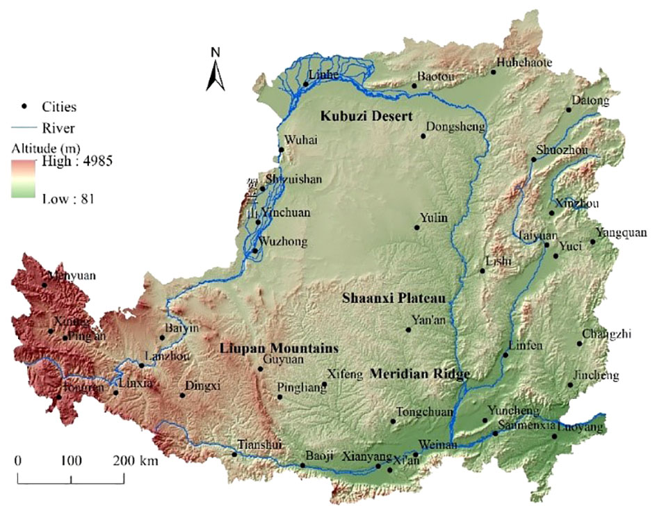
Figure 1 Geographic location of the Loess Plateau.
2.2 Estimation of fractional vegetation cover and human disturbance
This study estimated the FVC on the basis of the Normal Difference Vegetation Index (NDVI) data extracted from the Spatial Distribution Dataset of Annual Vegetation Index (NDVI) in China with the spatial resolution of 1 km, which were provided by the Center for Resource and Environmental Science and Data of the Chinese Academy of Sciences (http://www.resdc.cn). This study extracted the NDVI data of the study area according to boundary data of the Loess Plateau and subsequently estimated the FVC during 2000-2019 with Equation (1) (Chen et al., 2023).
where FVC is the fractional vegetation coverage, NDVI is the NDVI value in each pixel, and NDVImax and NDVImin are the NDVI values in the densely vegetated pixels and sparsely vegetated pixels, respectively. This study then categorized the FVC into five classes, i.e., low coverage (0<FVC ≤ 30%), moderate-low coverage (30% <FVC ≤ 45%), moderate coverage (45%<FVC ≤ 60%), moderate-high coverage (60%<FVC ≤ 75%) and high coverage (FVC>75%) according to the “Soil Erosion Classification and Grading Standard” (2008). Thereafter, this study carried out trend analysis of the FVC at the pixel scale using the one-way linear regression method (Zhu et al., 2018), which reflected the trend of FVC the slope in Equation (2):
where slope is the slope of the trend line; ti is the ith year of 2000-2019; n is the total length of the time series (n = 20); is the FVC in the ith year. The F-test was further conducted to analyze the significance of the results to check whether the change of FVC is significant. The study area was thereafter classified into five categories according to the results of linear regression and F-test, i.e., significantly improved areas (slope>0 and P<0.01), improved areas (slope>0 and 0.01<P<0.05), basically stable areas (P>0.05), degraded areas (slope<0 and 0.01<P<0.05), and significantly degraded areas (slope<0 and P<0.01). Additionally, this study used the coefficient of variation (CV) of the FVC to further reveal the spatial characteristics of the FVC change. The FVC change in the study area was thereafter classified into five categories according to the CV, namely, very low variation (CV ≤ 0.1), low variation (0.1<CV ≤ 0.2), moderate variation (0.2<CV ≤ 0.3), high variation (0.3<CV ≤ 0.4), and very high variation (CV>0.40).
The human disturbance intensity reflects the degree of human utilization, modification and exploitation of the terrestrial surface (Zhu et al., 2018). As for a given region, there are generally multiple ecosystem types with various area percentage and different human disturbance intensity. This study therefore determined the grade of human disturbance intensity of different ecosystem types according to the results of previous studies at the spatial resolution of 1 km (Zhao et al., 2015; Liu et al., 2022) (Table 1). Specifically, the ecosystem types were determined based on the Global 30-meter Land Cover (GlobeLand30) dataset (http://www.globallandcover.com/), which contains 10 major land cover types, namely, cropland, forest, grassland, shrub land, wetland, water bodies, tundra, man-made land, bare ground, glacier, and permanent snow. This study estimated the human disturbance index with weighted summation, which can reflect the degree of human disturbance in the study area, and it was meanwhile standardized as Equation (3):
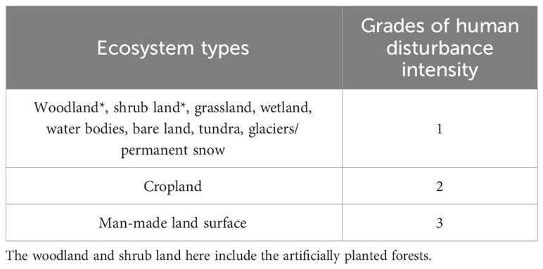
Table 1 Grades of the human disturbance intensity of different ecosystem types.
where HDI is the human disturbance index, ranging between 0-1. Di is the grade of human disturbance intensity of the ith ecosystem types, Propiis the area percentage of the ith ecosystem types. The human disturbance intensity in the study area was categorized with the natural breakpoint method into five levels, i.e., very low disturbance, low disturbance, moderate disturbance, high disturbance and very high disturbance.
In this study, the changing trend of human disturbance was characterized with the degree of change of the human disturbance index (Vd), which was calculated as Equation (4):
where Vd is the degree of change of the human disturbance index from the ith year to the jth year. HDIi and HDIj are the human disturbance indices in the ith and jth year, respectively; Vd was further classified into five categories, i.e., significant decrease (Vd≤-0.1%), slight decrease (-0.1%<Vd≤-0.01%), basic equilibrium (-0.01%<Vd ≤ 0.01%), slight increase (0.01%<Vd ≤ 0.1%), and significant increase (Vd>0.1%).
2.3 Assessment of habitat quality
This study assessed the habitat quality with the InVEST model based on the regional land use, habitat suitability, threat source intensity and sensitivity (Huang et al., 2020; Liu et al., 2021) as Equation (5):
where is the habitat quality index of the xth grid of the jth ecosystem type; is the threat level of the xth grid of the jth ecosystem type; is the habitat suitability; k and z are the scale parameters, which are constants. The habitat quality of the study area was classified into five categories with the equal interval method, i.e., very high (0.8-1), high (0.6-0.8), moderate (0.4-0.6), low (0.2-0.4), and very low (0-0.2).
In this study, the man-made land surface and cropland were treated as the threat factors affecting the habitat quality of the study area. Taking into account the characteristics of terrain of the Loess Plateau and referring to the previous studies (Huang et al., 2020; Liu et al., 2021; Pan et al., 2022; Zhou and Cao, 2022), this study determined the distance and weight of the impact of the threat factors (Table 2). Thereafter, this study determined the habitat suitability of the different ecosystem types and their relative sensitivity to different threat sources (Table 3).
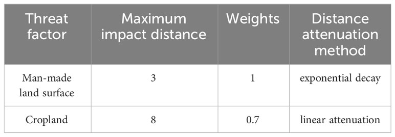
Table 2 Parameters of threat factors.
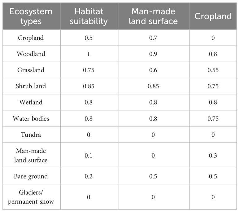
Table 3 Habitat suitability of different ecosystem types and their sensitivity to threat factors.
2.4 Exploration of response relationship of habitat quality change
This study used the 5 km × 5 km grid as the basic unit for exploring the spatial variation characteristics of habitat quality in response to FVC and human disturbance. Taking the habitat quality change as an explanatory variable and the change of FVC and human disturbance index as explanatory variables (Pan et al., 2022), this study analyzed the causal relationship between them with the Geographically Weighted Regression (GWR) in the ArcGIS software as Equation (6).
where is the habitat quality change, of the ith sample unit; is the geocentric coordinates of the ith sample unit; β0(ui, vi) is the intercept of the ith sample unit; is the coefficient of local estimation about the independent variable ; and (i =1,2,…k) is the error term with a mean of 0 and variance of . The AICc model was used to estimate the bandwidth in this study, with a width of 14.49 km.
3 Results and discussion
3.1 Characteristics of FVC change
The results showed that the FVC of the Loess Plateau showed an overall increasing trend during the study period (R2 = 0.8116). In particular, the FVC after 2011 was all higher than the average annual value and peaked in 2018 (Figure 2). This may be mainly due to the fact that the pilot work of returning cropland to forests and grasslands was carried out in the study area in 1999 to control human activities such as land reclamation, and the vegetation restoration effect proved to be satisfactory, with a significant increase of the FVC. Additionally, the FVC of the Loess Plateau showed remarkable fluctuation, with a fluctuation cycle of approximately 5 years. This may be mainly due to the influence of climatic fluctuations such as precipitation variation.
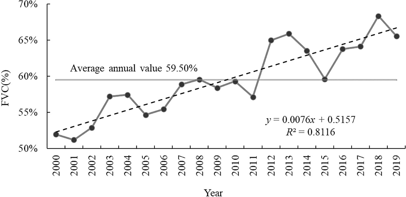
Figure 2 Inter-annual variation of the FVC of the Loess Plateau during 2000-2019.
The FVC was overall stable in most part of the Loess Plateau, generally showing a slightly increasing trend, which was closely related to the mountain range orientation and distribution of vegetation types. First, the average value of the FVC was overall high in the east part and low in the west part of the Loess Plateau during 2000-2019, showing a decreasing trend from east to west (Figure 3A). The area of high coverage accounted for 30.64% of the Loess Plateau, mainly distributed in the Luliang Mountains, Qinling Mountains, Ziwuling Mountains and Huangshui Valley, roughly coinciding with the direction of the mountain ranges, where the vegetation types dominantly included the forest, grassland, and cropland. The area of low coverage and moderate-low coverage accounted for 28.64% of the study area, mainly distributed in the Ordos Plateau, Helan Mountains, Yinshan Mountains, Mu Us Sandland, where the vegetation types were relatively few, mainly including grassland and desert. The area of moderate coverage and moderate-high coverage accounted for 40.72% of the study area, mainly distributed in the transition zone between the areas of high coverage and low coverage. Besides, most part of the Loess Plateau showed a significant increase of the FVC, accounting for 62.42% of the study area (Figure 3B). the area of significant decrease of the FVC accounted for only 2.41% of the study area, which was mainly distributed in the built-up parts of the urban areas and neighboring areas of cities such as Luoyang, Xi’an, Xianyang, Weinan, Yinchuan, Baotou and Hohhot. There was generally more drastic urban development and construction activities in these areas, which led to an obvious decreasing trend of the FVC. In addition, most part of the study area showed low variation of the FVC, accounting for 69.66% of the study area, where the CV was generally less than 0.2 (Figure 3C). Specifically, the CV was even lower in of the areas of high coverage, indicating the high stability of the FVC in these areas, which was primarily due to the fact that these areas were dominated by forest and the local ecosystems were very stable. Moreover, there was significant variation of the FVC in western part of the study area, mostly in the upper reach of the Yellow River. This was mainly due to the fragile ecological environment and the relatively homogenous vegetation types in these areas, which are generally very vulnerable to climate change and human disturbance.
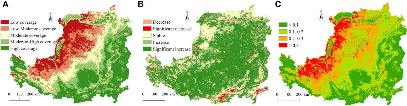
Figure 3 Spatial pattern of (A) fractional vegetation cover, (B) significance test results and (C) coefficient of variation of FVC on the Loess Plateau.
3.2 Characteristics of human disturbance
There was significant spatial and temporal heterogeneity of the human disturbance index in the Loess Plateau. First, the human disturbance index of the Loess Plateau showed an overall spatial pattern of increasing from the center to the surroundings (Figure 4A), with the mean value of 0.4862 in 2020, which was higher than the national average level (0.4154). Specifically, there was dominantly moderate disturbance in most part of the Loess Plateau in 2000, accounting for 41.74% of the study area (Table 4), which was mainly distributed in the forest and forested grassland zones. The area of low disturbance accounted for 35.29% of the study area, which was mainly distributed in the forest and grassland areas of the Kubuqi Desert, Mu Us Desert, Meridian Ridge, Lvliang Mountains and hilly forest and grassland areas of the Haidong Mountains. The areas of moderate or low disturbance together accounted for 77.03% of the study area, covering the main part of the Loess Plateau. The areas of high and very high disturbance accounted for 21.90% and 1.06% of the study area, respectively, which were mainly distributed in urban built-up areas in border regions of the Loess Plateau.
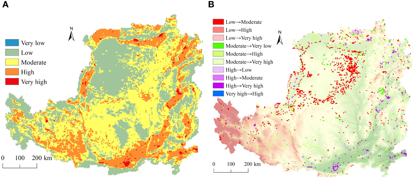
Figure 4 Spatial pattern of the classes of the human disturbance index in 2020 (A) and interconversion of human disturbance classes during 2000-2020 (B) in the Loess Plateau.
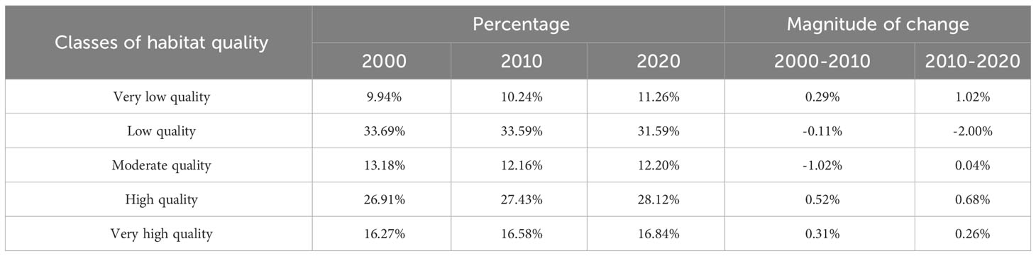
Table 4 Statistics of the habitat quality change in the Loess Plateau.
The spatial characteristics of human disturbance in the Loess Plateau was further revealed with the inter-transformation of different human disturbance classes (Figure 4B), which suggested the human disturbance level kept approximately stable in 91.83% of the study area. The change of the human disturbance level occurred in a few parts of the study area, which were mainly concentrated in the desert grassland area along the Dongsheng-Yulin route. There was mainly the transformation from low disturbance to moderate disturbance and from moderate disturbance to high disturbance, which accounted for 41.93% and 32.16% of the total area with the change of the human disturbance level, respectively.
3.3 Characteristics of habitat quality change
The habitat quality in the Loess Plateau showed remarkable spatial heterogeneity during the study period (Figure 5). Specifically, the percentage of areas of high or very high habitat quality was 44.96% in 2020, with an overall increase of 1.78% during the study period. These areas were mainly distributed in the Taihang Mountains, Luliang Mountains, northern Qinba Mountains, Qilian Mountains of Qinghai and Ziwuling Mountains, etc. There was mainly mountainous terrain in these areas, where the land use types are dominantly woodlands and grasslands and the main vegetation types included deciduous broadleaf forests, deciduous and evergreen broadleaf forests and alpine meadows, with a high FVC and limited human activities. The areas with low or very low habitat quality accounted for 42.84% of the study area in 2020, with a decrease of 0.79% during the study period. These areas were mainly distributed in the Ordos Plateau, Ningxia Plain, Hetao Plain, Fenwei Plain, etc., which were generally centered on the urban areas and expanded in all directions. These areas were generally dominated by cropland and desert grassland, but the encroachment of grassland by cropland reclamation and urban construction land expansion led to gradual degradation of the habitat quality. The areas with moderate habitat quality accounted for 12.02% of the study area in 2020, decreasing by 0.98% in comparison with that in 2000, these areas were scattered in the eastern part of the Ordos Plateau and the forest and forest-steppe ecological zones of the pre-mountain hills of the Yellow River in Shaanxi Province and Shanxi Province. Overall, the habitat quality was generally stable in areas with high habitat quality but showed relatively drastic variation in areas with low habitat quality, especially in the Hetao Plain, the Yinshan Mountains, the northern Shaanxi Plateau and the northern Longzhong Plateau.
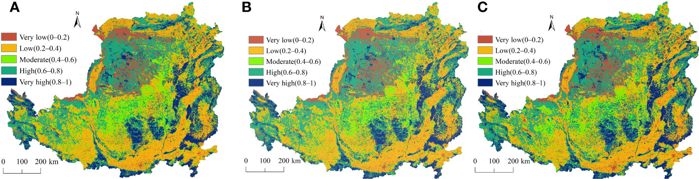
Figure 5 Habitat quality in the Loess Plateau in (A) 2000, (B) 2010 and (C) 2020.
The results suggested there was an overall improvement of habitat quality of the Loess Plateau (Table 4). Specifically, the area of high and very high habitat quality both showed an expanding trend during the study period, increasing by 0.84% and 0.94%, respectively. Meanwhile the area of low habitat quality showed a decreasing trend, decreasing by 0.11% and 2% during the first period (2000-2010) and the second period (2010-2020), respectively. The area of very low habitat quality increased to some degree, with an increase of 0.29% during the first period and 1.02% during the second period. By contrast, there was limited change of the area of moderate habitat quality. Besides, the areas with transformation of habitat quality classes accounted for 40.75% of the study area during 2000-2020, 20.85% out of which showed a shift to better habitat quality. In particular, 4.16% of the study area showed the transformation from very low habitat quality to high habitat quality, which was mainly distributed in the Erdos Plateau and the Haidong forest-steppe zone. Meanwhile 12.01% of the study area upgraded from low habitat quality to moderate habitat quality, which was mainly concentrated in the Hetao Plain, Yinshan Mountains, Shaanxi Plateau, and northern Longzhong Plateau, etc., accounting for the largest percentage of the area with transformation of habitat quality. 7.81% of the study area upgraded from low habitat quality to high habitat quality, which was widely distributed and scattered, generally with a small area. 7.02% of the study area upgraded from moderate habitat quality to high habitat quality, which was most prominent in the northern Shaanxi Plateau. 7.76% of the study area transformed from high habitat quality to very high habitat quality, which was widely distributed but generally with a small area, especially in the Mu Us Sandland and the Kubuqi Desert. This was primarily due to the fact that the continuous enhancement of regional ecological protection projects has contributed to the restoration and improvement of the habitat in these parts of the Loess Plateau to some extent (Zhao et al., 2017).
3.4 Response characteristics of habitat quality to influencing factors
The results showed there was significant spatial heterogeneity of the influence of FVC change and human disturbance on the habitat quality (Figure 6). On the whole, the FVC change showed a positive correlation with habitat quality change in 52.56% of the study area, indicting a greater effect on the habitat quality relative to human disturbance (37.38%). This suggested the positive influence of the FVC change on the habitat quality on the Loess Plateau gradually increased with the improvement of vegetation cover to some extent. Specifically, the correlation between the FVC change and habitat quality change was stronger in the Kubuqi Desert, Mu Us Desert, and Longzhong Plateau, where the local FVC was generally low and the implementation of ecological protection and construction projects effectively improved the regional vegetation cover and promoted the habitat quality while. By contrast, the areas with higher correlation between human disturbance and habitat quality change were mainly distributed in the Hetao Plain, Longzhong Plateau, Huangshui Valley, Haidong Forest Meadow Area, Qinba Mountainous Area, Shaanxi Plateau and the western part of Ordos Plateau. These areas were generally more densely populated, with larger area of cropland and construction land, and it is therefore necessary to continue to maintain the ecological protection and construction projects in these areas in order to obtain greater ecological benefits. Additionally, the spatial pattern of areas with lower correlation between FVC change and habitat quality change was generally consistent with that of the areas with high or very high FVC, where the ecological background was generally better and the vegetation types were primarily forest, grassland and meadow, with limited change of the FVC. By contrast, the areas with low correlation between human disturbance and habitat quality change were primarily consistent with the areas of low or very low habitat quality, where there was generally limited population.
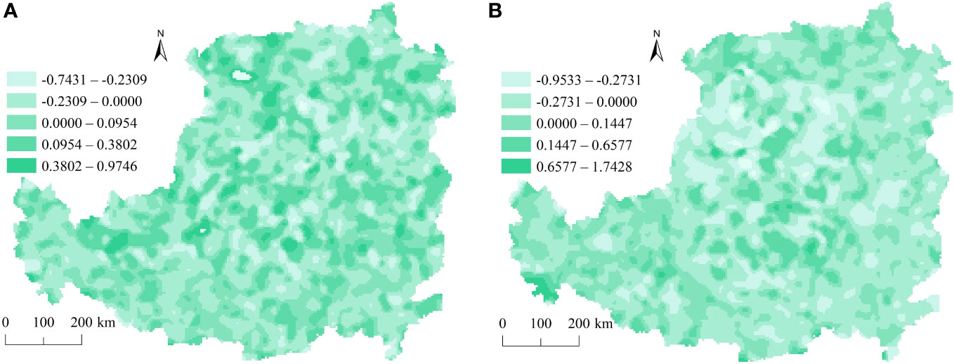
Figure 6 Spatial distribution of regression coefficients of the GWR model for habitat quality change in the Loess Plateau based on: (A) Fractional vegetation cover and (B) Human disturbance.
4 Discussion
The results of this study were consistent with previous studies (Zhou and Cao, 2022; Wang Y. et al., 2023), that is, the habitat quality of the Loess Plateau showed a significant spatial agglomeration trend and tended to improve continuously. On the spatial scale, the areas with high habitat quality were mainly distributed in the Taihang Mountains, Luliang Mountains, northern Qinba Mountains, and Ziwuling Mountains, etc. The land cover types in these areas were dominated by woodlands and grasslands, and the main vegetation types were deciduous broadleaf forests, deciduous and evergreen broadleaf forests, and alpine meadows, etc., the FVC of which was generally high. While the habitat quality was generally low in the Ordos Plateau, Ningxia Plain, Hetao Plain, Fenwei Plain, which was mainly due to the encroachment of grasslands by cropland reclamation and urbanization, showing a pattern of spreading in all directions with the towns and cities as the center. In particular, the habitat quality of the Loess Plateau showed significant spatial agglomeration. The high agglomeration areas were generally closely associated with the distribution of woodland and grassland, where there was low human disturbance and high habitat quality. While low agglomeration areas were generally in areas with more intensive human disturbance and lower habitat quality. In particular, land use change as one of the most important ways the human beings intervene in the ecological environment has been one of the most important influencing factor of the habitat quality in the Loess Plateau, among which the change of cropland and construction land greatly affects the regional habitat quality. The habitat quality of the Loess Plateau generally tended to improve on the time scale, which is mainly due to the implementation of policies such as “returning cropland to forests and grasslands” and also reflects the gradual realization of the effectiveness of some other ecological protection measures. It is therefore necessary to further maintain the ecological protection on the Loess Plateau at the current level, with more attention continuously paid to the changes in cropland and construction land, and ecological restoration measures should be tailored to local conditions in order to further improve the habitat quality.
The InVEST model was widely used to estimate the habitat quality in this study, which can increase the visibility of the results, but the parameter settings of the threat factors still rely heavily on expert knowledge, which is somewhat subjective and still needs to be further improved. It is necessary to further optimize parameter settings and carry out parameter localization based on long-term field observation and comprehensively consider the effects of different vegetation types, threat types, and FVC of the same vegetation types on the habitat quality in the future studies. Besides, the study area of this study is too large for carrying out large-scale validation, and small-scale experimental observations can be carried out for model validation and optimization according to the specific conditions in the future. In addition, this study only quantitatively analyzed the relationship between the habitat quality change and the FVC change and human disturbance, and it is necessary to further strengthen the research on the impacts of more influencing factors (e.g., climate change) on the habitat quality in the future research. In particular, it is necessary to further explore the specific impacts of different human disturbance on the habitat quality so as to better support the formulation and adjustment of major national policies.
Changes of vegetation cover in the Loess Plateau are influenced by a combination of geographic factors, which may interact with each other at the same time. For example, returning farmland to forests and grasslands on the slopes can lead to large-scale restoration of vegetation, which in turn has a feedback effect on the regional climate such as the local precipitation processes and ultimately contributes to the re-establishment of vegetation. In this cyclic feedback process, human activities can influence the change direction of vegetation to a certain extent. Besides, this study used the FVC as a factor affecting habitat quality because it is also a manifestation form of the impacts of human activities, which can influence the change of habitat quality. The human disturbance intensity is a comprehensive indicator that can reflect the extent to which all human interventions affect the ecosystems, but it is still a crude way to quantify the characteristics of human activities with only the land use change. In addition, ecological disturbance and restoration are a continuous process, but this study only obtained the human disturbance intensity in 2000, 2010 and 2020, the data of which are discrete, and the choice of time interval and spatial scale may lead to some uncertainties of the results. Moreover, this study used different grid scales such as 1 km and 5 km, and this study ignored the impacts of geographic, administrative, and economic distances due to the large area of the study area, all of which may lead uncertainties in the results to some degree. It is therefore necessary to take into account more natural factors and further refine the effects of human behaviors on vegetation cover in the future research. For example, it is necessary to use long time-series land use change as the basic data and explore long time-series habitat quality change and its response to drivers on multiple scales and take into multiple factors so as to better provide scientific support for the regional harmonious development of human and nature.
5 Conclusions
This study explored spatial and temporal change of the habitat quality in the Loess Plateau during 2000-2020 with the InVEST model and revealed its response characteristics to the FVC change and human disturbance with the GWR model. The major conclusions were as follows:
(1) The habitat quality exhibited significant spatial and temporal heterogeneity in the Loess Plateau, and the spatial distribution of areas of high habitat quality was generally consistent with the direction of the Taihang Mountains, Luliang Mountains and Ziwuling Mountains during the study period, which was highly consistent with the spatial distribution pattern of the FVC.
(2) The habitat quality tended to improve in 51.16% of the study area, which was a direct and concrete manifestation of the national ecological protection and restoration policies, and the areas of high or very high habitat quality increased by 1.78%, primarily including the Hetao Plain, Shanbei Plateau, northern Longzhong Plateau, Mu Us Sandy, and Kubuqi Desert.
(3) The FVC change played a dominant role (52.56%) in influencing the habitat quality change in the Loess Plateau.
Data availability statement
The raw data supporting the conclusions of this article will be made available by the authors, without undue reservation.
Author contributions
NS: Investigation, Methodology, Software, Writing – original draft. HCY: Data curation, Formal analysis, Funding acquisition, Resources, Writing – original draft. QW: Methodology, Resources, Validation, Visualization, Writing – original draft. YH: Data curation, Resources, Software, Validation, Visualization, Writing – original draft. HMY: Conceptualization, Funding acquisition, Project administration, Supervision, Writing – review & editing. NX: Funding acquisition, Project administration, Resources, Supervision, Writing – review & editing.
Funding
The author(s) declare financial support was received for the research, authorship, and/or publication of this article. This research was funded by Biodiversity Survey and Assessment Project of the Ministry of Ecology and Environment, China (2019HJ2096001006), 333 Talent Project of Hebei Province (C20221028), Youth top talent program of Hebei Education Department (BJ2019045) and Natural Science Foundation of Hebei Province (G2023403002).
Conflict of interest
The authors declare that the research was conducted in the absence of any commercial or financial relationships that could be construed as a potential conflict of interest.
Publisher’s note
All claims expressed in this article are solely those of the authors and do not necessarily represent those of their affiliated organizations, or those of the publisher, the editors and the reviewers. Any product that may be evaluated in this article, or claim that may be made by its manufacturer, is not guaranteed or endorsed by the publisher.
References
Baral H., Keenan R. J., Sharma S. ,. K., Stork N. E., Kasel S. (2014). Spatial assessment and mapping of biodiversity and conservation priorities in a heavily modified and fragmented production landscape in north-central Victoria, Australia. Ecol. Indic. 36 (1), 552–562. doi: 10.1016/j.ecolind.2013.09.022
Chen S. J., Xu G. C., Lv Z. P., Ma M. Y., Li H. Y., Zhu Y. Y. (2023). Spatio-temporal variations of fractional vegetation cover and its response to climate change and urbanization in China. Arid. Land. Geogr. 46 (5), 742–752. doi: 10.12118/j.issn.1000-6060.2022.375
Gao H. D., Li Z. B., Jia L. L., Li P., Xu G. C., Ren Z. P., et al. (2016). Capacity of soil loss control in the Loess Plateau based on soil control degree. J. Geogr. Sci. 26 (4), 457–472. doi: 10.1007/s11442-016-1279-y
Grondin P., Gauthier S., Borcard D., Bergeron Y., Noël J. (2014). A new approach to ecological land classification for the Canadian boreal forest that integrates disturbances. Landscape Eco. 29 (1), 1–16. doi: 10.1007/s10980-013-9961-2
He P., Xu L. H., Liu Z. C., Jing Y. D., Zhu W. B. (2021). Dynamics of NDVI and its influencing factors in the Chinese Loess Plateau during 2002–2018. Reg. Sustain. 2 (1), 36–46. doi: 10.1016/j.regsus.2021.01.002
Hou Y. Z., Zhao W. W., Liu Y. X., Yang S. Q. (2021). Relationships of multiple landscape services and their influencing factors on the Qinghai–Tibet Plateau. Landscape Eco. 36, 1987–2005. doi: 10.1007/s10980-020-01140-3
Huang Z. D., Bai Y., Alatalo J. M., Yang Z. Q. (2020). Mapping biodiversity conservation priorities for protected areas: a case study in Xishuangbanna Tropical Area, China. Biol. Conserv 249, 108741. doi: 10.1016/j.biocon.2020.108741
Jiang W. K., Wu J. Y. (2021). Spatial-temporal evolution of habitat quality in Guangdong-Hong Kong-Macao Greater Bay Area based on regional GDP and population spatial distribution. Acta Ecol. Sin. 41 (5), 1747–1757. doi: 10.5846/stxb202004050806
Liu C. F., Wang C. (2018). Spatial-temporal evolution characteristics of habitat quality in the Loess Hilly Region based on land use change: a case study in Yuzhong County. Acta Ecol. Sin. 38 (20), 7300–7311. doi: 10.5846/stxb201710101800
Liu M. Z., Zhang H. J., Wang Y. F., Liu H. W. (2021). Characteristics of habitat quality in the Agro-pastoral Ecotone of Northern China based on land uses. Res. Soil Water Conserv. 28 (3), 156–162. doi: 10.13869/j.cnki.rswc.2021.03.018
Liu X. M., Wang C., Xiao R. L., Fu Z., Lv N., Yuan J. F., et al. (2022). Characteristics of human disturbance and the spatio-temporal changes of important ecological protection areas in China. Sci. Geogr. Sin. 42 (6), 1082–1090. doi: 10.13249/j.cnki.sgs.2022.06.014
Lu C., Shi L., Zhao X. C., Li W., Gustavel Q. (2021). Evaluation and planning of urban geological and ecological environment quality. Arab. J. Geosci. 14 (2), 71–78. doi: 10.1007/s12517-020-06335-1
Luan W. F., Li X. (2021). Rapid urbanization and its driving mechanism in the Pan-Third Pole region. Sci. Total. Environ. 750, 141270. doi: 10.1016/j.scitotenv.2020.141270
Luo Q. L., Luo L. Y., Zhou Q. F., Song Y. (2019). Does China’s Yangtze River Economic Belt policy impact on local ecosystem services? Sci. Total. Environ. 676, 231–241. doi: 10.1016/j.scitotenv.2019.04.135
Nelson E., Mendoza G., Regetz J., Polasky S., Tallis H., Cameron D. R., et al. (2009). Modeling multiple ecosystem services, biodiversity conservation, commodity production, and tradeoffs at landscape scales. Front. Ecol. Environ. 7 (1), 4–11. doi: 10.1890/080023
Niu L. N., Shao Q. Q., Ning J., Huang H. B. (2022). Ecological changes and the tradeoff and synergy of ecosystem services in western China. Acta Geogr. Sin. 77 (1), 182–195. doi: 10.1007/s11442-022-1985-6
Pan Y., Yin Y. H., Hou W. J., Han H. S. (2022). Spatiotemporal variation of habitat quality in the Source Region of the Yellow River based on land use and vegetation cover changes. Acta Ecol. Sin. 42 (19), 7978–7988. doi: 10.5846/stxb202105131254
Rechsteiner C., Zellweger F., Gerber A., Breiner F. T., Bollmann K. (2017). Remotely sensed forest habitat structures improve regional species conservation. Remote Sens. Ecol. Conserv. 3 (4), 247–258. doi: 10.1002/rse2.46
Sallustiol L., Detoni A., Strollo A., Febbraro M. D., Gissi E., Casella L., et al. (2017). Assessing habitat quality in relation to the spatial distribution of protected areas in Italy. J. Environ. Manage. 201, 129–137. doi: 10.1016/j.jenvman.2017.06.031
Shi N. N., Quan Z. J., Han Y., Wang Q., Quan Z. J. (2016). Spatial-temporal changes of vegetation NDVI and its relationship with regional climate in Wood-grass Ecotone of Northeast China during 2000-2010. Remote Sens. Ecol. Conserv. 23 (5), 175–182. doi: 10.13869/j.cnki.rswc.20160617.009
Sun X., Jiang Z., Liu F., Zhang D. (2019). Monitoring spatial-temporal dynamics of habitat quality in Nansihu Lake basin, eastern China, from 1980 to 2015. Ecol. Indic. 102, 716–723. doi: 10.1016/j.ecolind.2019.03.041
Tang R. Y., Zhao X., Zhou T. (2018). Assessing the impacts of urbanization on albedo in Jing-Jin-Ji Region of China. Remote Sens. 10 (7), 1096–1096. doi: 10.3390/rs10071096
Wang J. F., Liu X. L., Wang S., Li Q., Hu S. X., Li L. F. (2023). Spatial-temporal evolution and simulation of multi-factor landscape pattern and habitat quality on the Loess Plateau based on ecological zoning. Yellow. River. 45 (1), 105–111. doi: 10.5846/stxb202109022475
Wang J., Yan Y. L., Wang J. M., Ying L. X., Tang Q. (2021). Temporal-spatial variation characteristics and prediction of habitat quality in Min River Basin. Acta Ecol. Sin. 41 (14), 5837–5848. doi: 10.5846/stxb202010142618
Wang S. W., Chen H. Q., Su W. J., Cui S. H., Xu Y. R., Zhou Z. Q. (2023). Research on habitat quality assessment and decision-making based on Semi-supervised Ensemble Learning method—Daxia River Basin, China. Ecol. Indic. 156, 111153. doi: 10.1016/j.ecolind.2023.111153
Wang S. Q., Liu Y. X., Li Y., Fu B. J. (2023). Research progress on the ecosystem services on the Loess Plateau during the recent 20 years. Acta Ecol. Sin. 43 (1), 26–37. doi: 10.5846/stxb202204291190
Wang Y., Hao L. N., Xu Q., Li J. Q., Chang H. (2023). Spatial-temporal variation of vegetation coverage and its geographical factors analysis on the Loess Plateau from 2001 to 2019. Acta Ecol. Sin. 43 (6), 2397–2407. doi: 10.5846/stxb202106241686
Wilsey C. B., Lawler J. J., Cimprich D. A. (2012). Performance of habitat suitability models for the endangered black-capped vireo built with remotely-sensed data. Remote Sens. Environ. 119, 35–42. doi: 10.1016/j.rse.2011.12.002
Wu R. D. (2016). China’s ecosystems: Focus on biodiversity. Nature 353 (6300), 657. doi: 10.1126/science.aah3994
Yang J., Xie B. P., Zhang D. G. (2021). Spatial-temporal evolution of habitat quality and its influencing factors in the Yellow River Basin based on InVEST model and geodetector. J. Desert. Res. 41 (4), 12–22. doi: 10.7522/j.issn.1000-694X.2021.00026
Zellweger F., Baltensweiler A., Ginzler C., Roth T., Braunisch V., Bugmann H., et al. (2016). Environmental predictors of species richness in forest landscapes: Abiotic factors versus vegetation structure. J. Biogeogr. 43 (6), 1080–1090. doi: 10.1111/jbi.12696
Zhang H., Han W. H., Song J. Y., Li M. (2021). Spatial-temporal variation of habitat quality in Qilian Mountain National Park. Chin. J. Ecol. 40 (5), 1419–1430. doi: 10.13292/j.1000-4890.202105.029
Zhao A., Zhang A., Lu C., Wang D., Wang H., Liu H. (2017). Spatiotemporal variation of vegetation coverage before and after implementation of Grain for Green Program in Loess Plateau, China. Ecol. Eng. 104, 12–33. doi: 10.1016/j.ecoleng.2017.03.013
Zhao G. S., Liu J. Y., Kuang W. H., Ouyang Z. Y., Xie Z. L. (2015). Disturbance impacts of land use change on biodiversity conservation priority areas across China: 1990–2010. Acta Geogr. Sin. 25 (5), 515–529. doi: 10.1007/s11442-015-1184-9
Zhao X. Y., Ma P. Y., Li W. Q., Du Y. X. (2021). Spatiotemporal changes of supply and demand relationship of ecosystem services in the Loess Plateau. Acta Geogr. Sin. 76 (11), 2780–2796. doi: 10.11821/dlxb202111013
Zhou L. H., Cao R. C. (2022). Spatial-temporal evolution of habitat quality and its influencing factors in Loess Plateau. Bull. Soil Water Conserv. 42 (6), 343–350.
Zhou Q., Zhao X., Wu D. H., Tang R., Peng Y. (2019). Impact of urbanization and climate on vegetation coverage in the Beijing-Tianjin-Hebei Region of China. Remote Sens. 11 (20), 2452–2452. doi: 10.3390/rs11202452
Keywords: habitat quality, InVEST, human disturbance index, FVC, loess plateau
Citation: Shi N, Yang H, Wang Q, Han Y, Yan H and Xiao N (2023) Spatiotemporal variation of habitat quality and its response to fractional vegetation cover change and human disturbance in the Loess Plateau. Front. Ecol. Evol. 11:1302224. doi: 10.3389/fevo.2023.1302224
Received: 26 September 2023; Accepted: 04 December 2023;
Published: 19 December 2023.
Edited by:
Xueru Zhang, Hebei University of Economics and Business, ChinaReviewed by:
Zhe Feng, China University of Geosciences, ChinaGuangshuai Zhao, National Forestry and Grassland Administration, China
Quanzhi Yuan, Sichuan Normal University, China
Copyright © 2023 Shi, Yang, Wang, Han, Yan and Xiao. This is an open-access article distributed under the terms of the Creative Commons Attribution License (CC BY). The use, distribution or reproduction in other forums is permitted, provided the original author(s) and the copyright owner(s) are credited and that the original publication in this journal is cited, in accordance with accepted academic practice. No use, distribution or reproduction is permitted which does not comply with these terms.
*Correspondence: Haiming Yan, haiming.yan@hgu.edu.cn; Nengwen Xiao, xiaonw@163.com