Vegetation indices monitoring by using copernicus data in the old-growth forests of the Republic of Srpska/Bosnia and Herzegovina
 Zoran Govedar
 Nemanja Anikić
- Faculty of Forestry, University of Banja Luka, Banja Luka, Bosnia and Herzegovina
Introduction: Old-growth forests (OGFs) are vital for global biodiversity, acting as irreplaceable carbon sinks, fostering ecosystem stability, and preserving unique ecological and cultural heritage. There are three old-growth forests in the Republic of Srpska/Bosnia and Herzegovina (Lom, Janj, and Perućica). They are dominated by mixed forests of beech, fir, and spruce (Piceo-Abieti-Fagetim illyricum). The satellite imagery results confirm that the vegetational indices are crucial for monitoring old-growth forests. Vegetation indices provide significant information for monitoring forest ecosystems. Based on Copernicus Sentinel-2 images, remote sensing is enabled, providing data in various spatial and spectral resolutions. The analysis of images related to old-growth forests allows for monitoring the spatial dynamics of changes in vitality and the health status of forests. This research aims to characterize old-growth forests from space through vegetation indices to obtain a more in-depth analysis of the ecological condition of these forests.
Methods: The research methodology includes the application of Sentinel 2A satellite imagery, which is taken from the European Space Agency (ESA) database. The Sentinel 2 mission consists of two identical satellites (Sentinel 2A and Sentinel 2B) that have multispectral sensors with 13 spectral channels (bands) at spatial resolutions of 10, 20, and 60 m. The analysis included the normalized difference vegetation index (NDVI), enhanced vegetation index (EVI), soil-adjusted vegetation index (SAVI), and visible atmospheric resistance index (VARI). For determining the significance of differences in vegetation index magnitudes between old-growth forests, a one-way analysis of variance with equal repetitions was employed.
Results and discussion: The parts of old-growth forests are located in different stages of development, and the trees in them are characterized by different degrees of vitality and have different values of vegetation indices. It is assumed that parts of old-growth forests in the terminal phase of development with a large number of diseased and rotting trees have the smallest sizes of vegetation indices. This research aims to characterize old-growth forests from space through vegetation indices to obtain a more in-depth analysis of the ecological condition of these forests. Using satellite imagery and their analysis of the obtained sizes of vegetation indices, it is observed that there is a significant difference in their sizes between old-growth forests. The Janj old-growth forest stands out as the area with the highest NDVI values, followed by the Lom old-growth forest, while the Perućica old-growth forest has the lowest NDVI values. However, the Perućica old-growth forest has significantly higher values of EVI and SAVI vegetation indices, while the other two old-growth forests have approximately similar values. The VARI index values are highest in the Lom old-growth forest, slightly lower in the Perućica old-growth forest, and lowest in the Janj old-growth forest. The results of these studies indicate statistically significant differences in vegetation index magnitudes between old-growth forests. The application of Copernicus satellite data enables the monitoring of changes in vegetation index values, which is of great assistance in spatially defining the developmental stages in old-growth forests (OGFs). Considering the relatively small number of sample areas covered by these studies, similar research needs to be conducted on a larger number of sample areas (replications), especially during the vegetation period.
1 Introduction
Old-growth forests (OGFs) are of paramount importance due to their unparalleled ecological significance. These ancient ecosystems, which are characterized by mature and undisturbed stands of trees, play a critical role in biodiversity conservation, providing habitats for numerous plant and animal species, including many that are rare, endemic, or endangered (Spies and Franklin, 1996). In addition, their importance is increasing due to specific intact microhabitats and the knowledge of carbon dioxide sequestration (Luyssaert et al., 2008).
The identification of developmental stages in OGFs is a key element in the study of forest ecosystems and their sustainable management. OGFs of the Republic of Srpska represent significant forest areas that require detailed monitoring and analysis of the state of vegetation to plan protection and management activities adequately. To form an OGF, nature needs to develop through its natural course, without human-induced activities. Depending on habitat conditions and tree species, the time period for its development lasts at least 120 years. (Lazarova et al., 2014). The OGF is an ecologically stable forest with a solid and dynamic balanced relationship between climate, land, and organisms, and at the same time, preserved from human influence, which, in turn, could change the laws of life processes and the structure of the OGF itself (Korpel, 1995). OGFs are historically assumed to be a treasure of natural heritage because they preserve some old but well-verified messages about stability, security, and harmony of survival (Hartman, 1999).
Additionally, old-growth forests serve as substantial carbon sinks, sequestering significant amounts of carbon dioxide through the photosynthetic activity of their large, mature trees and storing it in their biomass. This carbon storage helps regulate atmospheric carbon levels, mitigating the greenhouse effect and contributing to the global fight against climate change. The intricate structure of old-growth forests also promotes watershed protection, prevents soil erosion, and maintains stable hydrological patterns, ensuring a sustainable supply of clean water for both ecosystems and human communities. A comprehensive understanding of the importance of old-growth forests is crucial for informed conservation and land management policies (Luyssaert et al., 2008).
The notion of old-growth forests may include both primary and secondary forests as long as the stands have developed for a long period without significant anthropogenic disturbance. Old-growth forests are characterized by functional, structural, and compositional characteristics that are normally associated with old primary forests of the same type. This notion is adopted by the European Commission (2015) and the Convention on Biological Diversity (CBD) (Barredo et al., 2021).
In addition, forests in Europe have been modified since the mid-Holocene period by clearing for cropland and pasture and have been used throughout history as a source of fuelwood and construction materials (Kaplan et al., 2009). As a consequence, intact forest ecosystems dominated by natural processes are rare in the EU (Potapov et al., 2017).
The old forestry expert, engineer Julius Fröhlich, who stayed in Bosnia at the beginning of the 20th century, noted that poor traffic links and the inability of mountain water flow for tree transport were the main reasons for the remaining “untouched” forests (Frölich, 1947). At the time, he warned Balkan foresters to preserve existing OGFs and noted that since forestry science began to develop, the need has emerged to learn from nature, especially in terms of the composition of forests and resources. Under the OGF, Fröhlich considers a forest composed of trees of all thickness and age, which was created naturally without human influence. Moreover, renowned Austrian forestry scientist Ludvig Dimitz, back in 1905, delighted by the magnificent appearance of these OGFs, noted that “There is a deep night here unseviated[sic] by no sunlight, the devical nature uncrothed[sic] and unharmed by any tools. Only heavenly fire, as pure as the one, quidsed[sic] over it. Yet powerful traces of struggle in this wilderness only bear witness to its size and they are a new form of its beauty.”
Research of OGFs in Bosnia and Herzegovina was actualized during the Austro-Hungarian rule (Dimitz, 1905) and then between the two world wars (Tregubov, 1941), but only after World War II, more extensive research of the basic structural characteristics of the Perućica, Janj, and Lom OGFs (Drinić, 1956) began, followed by the development of individual trees (Schütz, 1969), and ecological characteristics of OGFs (Manuševa et al., 1967; Fabijanić and Manuševa, 1984).
Interest in scientific research on OGF in the Republic of Srpska grew rapidly at the beginning of the 20th century, and this research was more comprehensive and related to the structure and natural regeneration and developmental phases (Govedar, 2005; Keren, 2015), stand assembly characteristics (Bottero et al., 2011; Garbarino et al., 2012), floristic composition, and plant communities (Bucalo et al., 2007). According to the EU Biodiversity Strategy for 2030, the overall goal of conserving at least 30% of the EU’s land area has been proposed, and OGF may consistently contribute to reaching this goal (Barredo et al., 2021). These forests represent large storage of carbon, sequestering it from the atmosphere and preserving the biodiversity and genetic potential of forests (Barredo et al., 2021). Given their high and unique ecological value, numerous activities in Europe have been initiated for mapping, determining the state, the dynamics of development, degree of vulnerability, and protection. Thus, since the beginning of the 20th century, new OGFs have been gradually established, which of now have a total of 12 in Bosnia and Herzegovina, 18 in Croatia, and 3 in Serbia. However, the most important and best-preserved OGFs of beech, fir, and spruce in Europe are found in the Republic of Srpska.
The developmental phases (the initial, optimal, and terminal) of old-growth forests include natural regeneration, stability, health status, and structural construction, so the values of vegetation indices differ. Previously mentioned studies are based on the hypothesis that the values of vegetation indices are higher at the initial and optimal stages than in the terminal development phase.
Vegetation indices are data calculated from different bands of multispectral recording based on absorption, transmission, and reflection of vegetation energy in different spectral bands. They serve as a graphic indicator of vegetation activity in the observed area. Differences in vegetation indices between covered and uncovered vegetation are noticeable (Xue and Su, 2017). Plants absorb wavelengths in the red and blue parts of the spectrum while repelling green light. Vegetation indices are dimensionless radiometric measurement parameters obtained by combining information from different bands, primarily the red and near-infrared (NIR) part of the electromagnetic spectrum (Maeda et al., 2016).
The primary aim of this research is to use vegetation indices for, i.e., remote detection, in accordance with the currently available study methods to identify development phases in old-growth forests located in the Republic of Srpska. In the research, a null hypothesis (Ho) was established, stating that there is no statistically significant difference in the magnitude of vegetation indices between OGFs.
2 Object of research
There are three OGFs in the Republic of Srpska, namely Lom, Janj, and Perućica (Figure 1). The management of these areas is defined based on the characteristics of a strictly natural reserve in accordance with the International Union for Conservation of Nature (IUCN) categories.
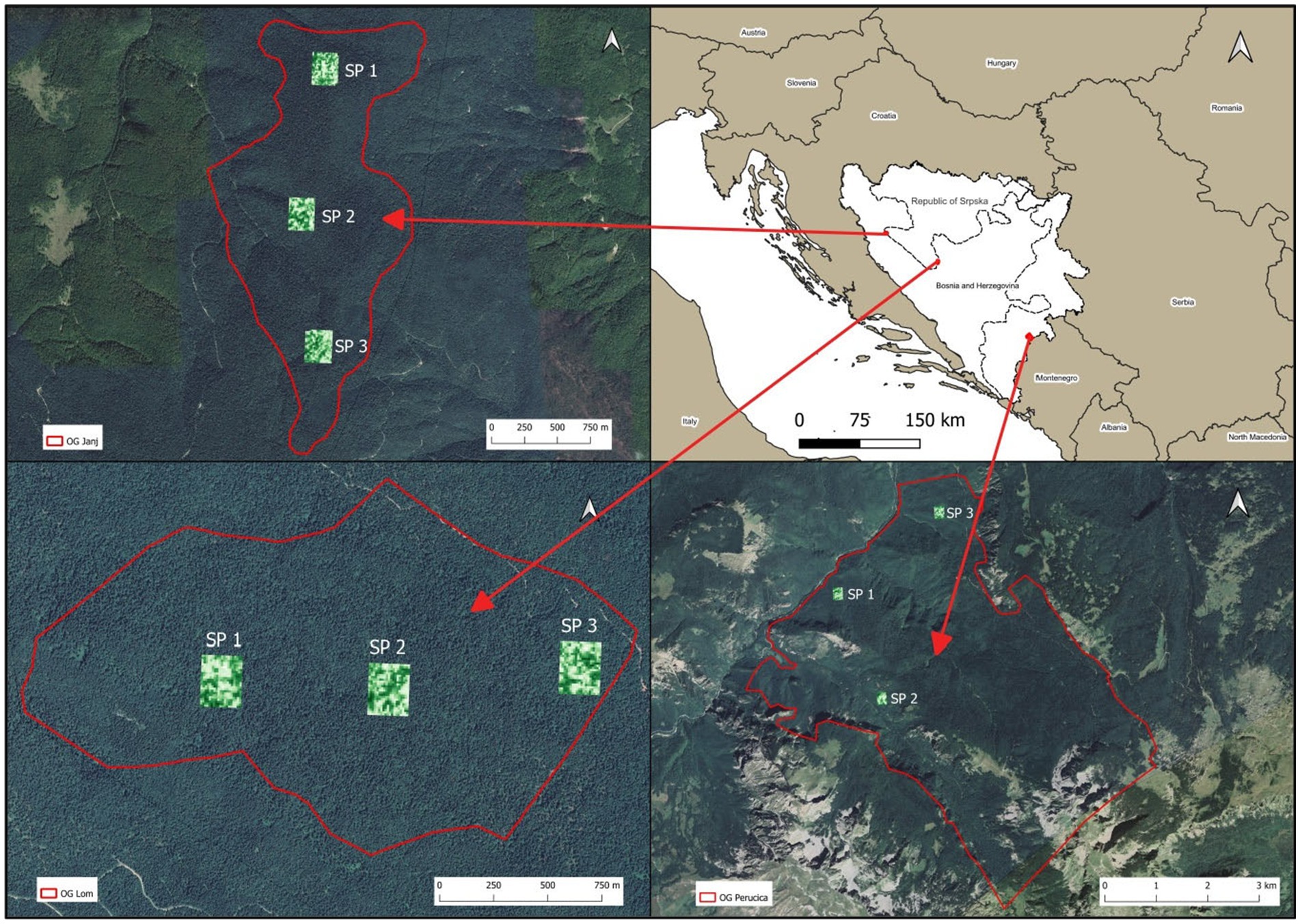
Figure 1. Geographical position of OGF and plot research.
The Lom OGF is located in the western part of the Republic of Srpska on the “Klekovača” Mountain massif, i.e., on the Lom mountain ridge. It extends between 44° 27′ and 44° 28′ latitude and from 16° 27′ to 16° 30′ east longitude. The total area of this reserve is 297.8 ha, of which the core of the OGF occupies 55.8 ha.
The Lom OGF reserve was protected in 1956 as a strict nature reserve in which economic activity and any works that could impair the free action of nature are prohibited. The reserve is used for scientific research (Maunaga et al., 2005). According to the categorization of the IUCN facility, it belongs to the category Ia (strict nature reserves), and in the original domestic official classification, it was classified in the I category (nature reserves), with an i protection regime. The area is located in the interior Dinarides, which is characterized by the clash of continental and maritime air masses. With this in mind, it can be concluded that the climate of this area is mountainous. The Lom OGF reserve extends in the higher sub-belt of the mountain belt, ranging from approximately 1,250 to 1,521 m above sea level (Bucalo et al., 2008).
Strict nature reserve OGF Janj (295.0 ha) is located in the western part of the Republic of Srpska. The reserve is located on the slopes of the Stolovaš massif in the municipality of Šipovo. It is located between 44° 07′ and 44° 10′ north latitude and between 17° 15′ and 17° 17′ East longitude and extends at an altitude between 1,180 and 1,510 m. Within the Janj OGF, there exists a designated portion of the reserve (core) spanning an area of 57.2 ha, subject to stringent regulations. The surface of the sheath, which surrounds the strict part of the reserve, is 237.0 ha, and the area of the unproductive part (path) is 0.8 ha. The World Heritage Committee of the United Nations Educational, Scientific, and Cultural Organization (UNESCO) declared the Janj OGF on 28 July 2021 as a natural asset of worldwide importance. The OGF thus became part of the expansion of the UNESCO world heritage sites within the project “Ancient and Primeval Beech Forests of the Carpathians and Other Regions of Europe” (94 sites from 18 countries).
The Perućica OGF is located in the southeastern part of Bosnia and Herzegovina on the northern side of the Maglić and Volujak Mountains. The area it occupies is 1.434 ha. The OGF is part of the Sutjeska National Park, formed on 9 February 1962. Perućica itself was placed under the protection of the state on 17 May 1952 as a strict nature reserve. On that occasion, 1.234 ha of forest stands of OGF composition were separated from the felling of trees and forest exploitation. After 2 years, the boundaries of the reserve were extended to non-forest areas to harmonize with the configuration of the terrain so that the reserve then had a total of 1.434 ha. The area was expanded due to the rounding of the OGF coverage into one cohesive unit (Fukarek, 1964).
The lowest point of the OGF is at the confluence of the Perućica stream in Sutjeska, 592 m above the sea level, and the highest point is the trigonometry of the Maglić Mountain, 2,386 m above the sea level (Lučić, 2016).
In the researched areas, a mountainous climate prevails. According to the Köppen climate classification (1991–2020), the Cfc climate type (cool temperate, no dry season, and warm summer) dominates in all OGFs. Precipitation ranges from 1,100 to 1,300 mm throughout the year, and the air temperature during the growing season ranges from 11 to 14°C.
3 Method of research
Using the QGIS version 3.22.13, three sample areas were placed in each OGFs (Figure 1). The dimensions of the sample areas are 200 × 250 m (5 ha). Later, the calculation of vegetation indices was carried out, and the zonal statistics for each sample area were used to comparatively analyze and interpret the results obtained.
The research methodology includes the application of Sentinel 2A satellite imagery, which is taken from the European Space Agency (ESA) database. The Sentinel 2 mission consists of two identical satellites (Sentinel 2A and Sentinel 2B) that have multispectral sensors with 13 spectral channels (bands) at spatial resolutions of 10, 20, and 60 m. Multispectral recordings were taken in July and August 2022 (OGF Janj on 17 August 2022, OGF Lom on 05 August 2022, and OGF Perućica on 8 July 2022). This period was chosen because it was a vegetation period, and vegetation was expected to be the most vital. The choice of downloaded shots also depends on cloudiness because it affects the quality of the shots and the accuracy of data processing. Therefore, days with minimal cloudiness above the research area were chosen to analyze the images.
Using the Semi-automatic Classification Plugin (SCP) tool, which represents an addition within QGIS, the atmospheric correction was performed employing the DOS1 method (Cangedo, 2018). Atmospheric correction was performed to avoid imperfections that could damage information, allowing one to obtain the value of physical surface reflection without the influence of atmospheric interference. The analysis is covered by the normalized difference vegetation index (NDVI), enhanced vegetation index (EVI), soil-adjusted vegetation index (SAVI), and visible atmospheric resistance index (VARI) (Table 1). These indices were chosen because they represent vegetation indices that are most often used in research of this type (da Silva et al., 2020).
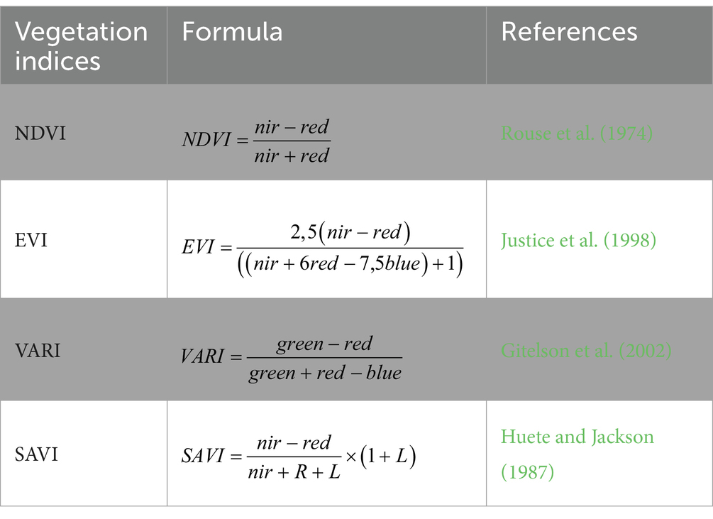
Table 1. Formulas of vegetation indices.
The utilization of various vegetation indices is crucial for assessing and monitoring plant health, as each index offers unique insights into different aspects of vegetation. For example, the NDVI is valuable for gauging overall plant vigor and health, while the enhanced vegetation index (EVI) provides enhanced sensitivity in areas with dense vegetation. Combining indices, such as the SAVI, can help account for soil background variations. The selection and integration of these indices play a pivotal role in comprehensive vegetation analysis and contribute to informed decision-making in diverse fields, including agriculture, forestry, and environmental science (Tucker, 1979; Gitelson et al., 2002; Smith et al., 2017).
With the help of these indices, the quantification of vegetation changes in the studied areas located at different stages of development in the OGF was carried out. This analysis includes a comparison of historical and current data, statistical tests, and other methods for obtaining relevant information.
In the final phase, an analysis of previously collected and processed data using the QGIS software program (version 3.22.13) was performed. QGIS provides a wide range of functions for working with different types of spatial data, including vector and raster data.
3.1 Accuracy assessment
To assess differences in vegetation index values, a one-way ANOVA with three groups (OGFs) and equal repetitions, specifically three sample plots (SP) in each group (OGF), was employed. The significance of differences between the empirical and theoretical levels was evaluated using the F test for a probability of α = 0.05, utilizing Statistica 10 software. The probability that a random variable of the F-distribution, with df1 = 2 degrees of freedom (the number of OGF reduced by 1) and df2 = 6 degrees of freedom (the number of SP reduced by 3), would exceed the F value is equal to the p-value. To make decisions about the significance of differences, the empirical level (p) was compared with the theoretical significance level (α = 0.05). Similar statistical assessments and research were conducted for various types of vegetation cover. To assess the significance of differences in the vegetation index values for different levels of grassland desertification, similar statistical analyses were performed (Xu et al., 2022): the physiological condition of forests during dry periods (Volcani et al., 2005) and the changes in vegetation indices under different forest harvesting methods (Abdollahnejad et al., 2019).
4 Results
The results of the research showed that the photosynthetic activity of forest trees was the highest in the Janj OGF because, on average, the highest value of NDVI was 0.85540, while the lowest was 0.63580 in the Perućica OGF (SP3) (Figure 2).
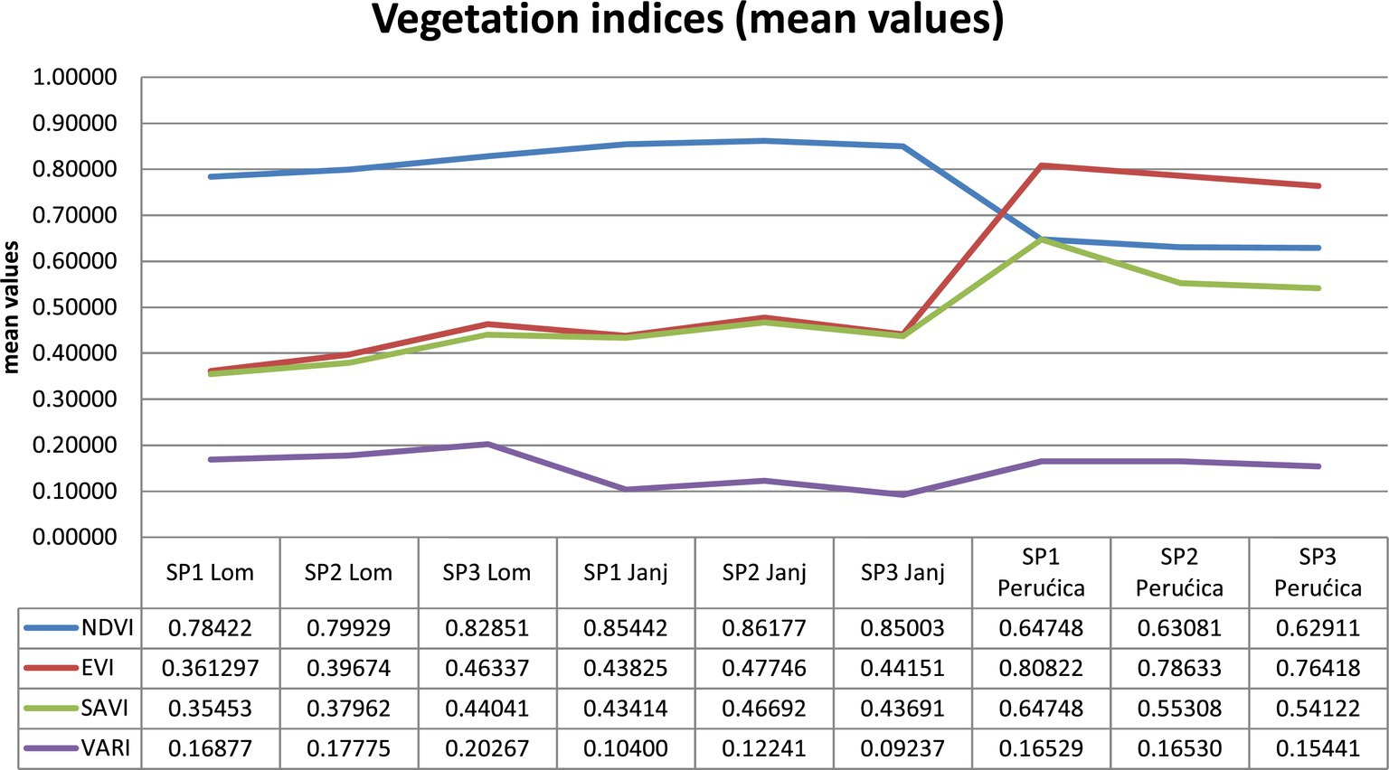
Figure 2. Average values of vegetation indices on sample areas.
The obtained results showed that EVI values were the highest in the Perućica OGF (values range from 0.76418 to 0.80822), while they were much lower in all sample areas in the Lom and Janj OGFs. The lowest values were in SP 1 (Lom), which was 0.36129, and slightly higher values were in SP 2 (Janj). These results suggested that atmospheric influences have a greater effect on the Lom and Janj OGFs than the Perućica OGF.
Considering the impact of land, the average values of the SAVI were the highest on SP 1 (Perućica), which was 0.64748. High values were also obtained on the other two sample areas in the same OGF (from 0.54122 to 0.55308). In the other two OGFs, values varied approximately. From the above, the significance and impact of the soil could be clearly noted.
VARI values on all sample surfaces in the Janj OGF were much lower than the other two surfaces. The values ranged from 0.09237 to 0.12241. In the Lom and Perućica OGFs, the values varied approximately, so the highest value on SP 3 (Lom) was 0.20267.
A simple analysis of variance showed that there were statistically significant differences in the sizes of vegetation indices between OGFs for probability p < 0.05 (Table 2).
Table 2. One-way ANOVA (vegetation indices).
5 Discussion
The use of vegetation index values enables the assessment of the vitality and physiological activity of stands in OGF. The vitality of parts of OGF ecosystems depends on the health of the trees, which also influences the definition of developmental stages. OGFs are characterized by the initial, optimal, and terminal developmental phases (Leibundgut, 1982; Korpel, 1995). These developmental stages differ in numerous taxonomic elements (growth, volume, vitality, the quantity of deadwood, etc.).
The terminal developmental phase is characterized by a decline in tree vitality, a reduced quantity of assimilation organs, and a lower number of trees per unit area. It is expected that sections of the OGF in the terminal phase will have lower values of vegetation indices compared to the initial and optimal phases. The spatial distribution of areas in different developmental phases (silvigenetic phases) is not interconnected as a whole; rather, their arrangement is of a random nature (Gilg, 2005).
The differences in vegetation index values also arise due to the various methods of tree harvesting depending on the forest’s purpose (Sader et al., 2003). Characteristic vegetation index values depend on tree species (Vorovencii et al., 2023), allowing combinations of satellite images to be used for more precise determination of indices and the classification of tree species. Modern trends in extreme climate disturbances often lead to bark beetle infestations (Ips spp.), especially in spruce forests. These infestations cause abrupt changes in tree vitality, which is reflected in the vegetation index magnitudes (Bozzini et al., 2023). Although OGFs are stable ecosystems with balanced developmental phase cycles lasting 150 to 200 years in the Dinaric region (Mlinšek, 1965), pest infestations occur during the physiological aging phase of trees (the beginning of the terminal phase). Vegetation indices can serve as a good indicator of the health condition caused by disturbances due to bark beetle activity.
NDVI is one of the most commonly used vegetation indices. This index is used to quantify vegetation and is calculated based on the difference between the red and infrared spectrums. Vegetation absorbs light in the red spectrum to a greater extent and reflects it in the infrared spectrum. NDVI values range on a scale of −1 to 1, where negative values indicate cultivated areas or water, where there is no vegetation, while positive values indicate the existence of vegetation (Rouse et al., 1974). High NDVI values (0.6–0.9 μm) correspond to the dense vegetation found in the moored and tropical forests or crops at the peak of growth (Huete and Jackson, 1987). Very small oscillations of NDVI in the Janj OGF are distinctive, and this is due to the large overgrowth and density of the lower floor, which is mainly made of beech (Fagus sylvatica L) (Figure 3). This is due to the fact that beech is a sciophyte capable of enduring the shading of older trees, providing it with greater flexibility regarding light regimes and more pronounced heliotropism compared to fir (Abies alba). The Lom OGF shows approximate values of NDVI from 0.78422 (SP1) to 0.82851 (SP3). These results indicate differences in vegetation density and vitality among the studied OGF.
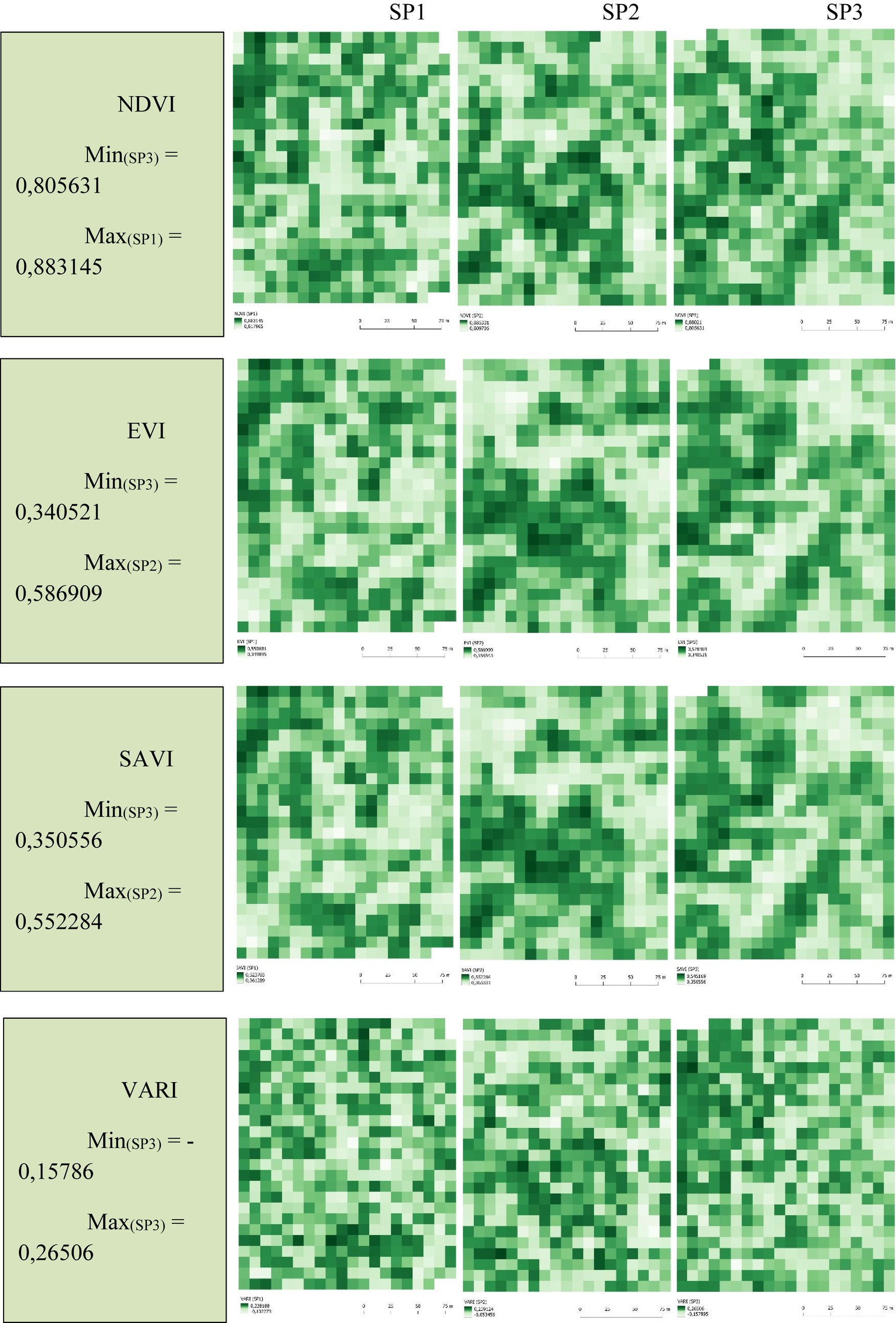
Figure 3. Vegetation indices on the sample plots—the Janj OGF.
The moderate resolution imaging spectroradiometer (MODIS) team has developed an EVI with the aim of taking full advantage of this sensor. EVI is similar to NDVI, a system with an additional feature of using the blue channel, which increases sensitivity to vegetation reflection. This modification of NDVI provides better detection of areas with greater biomass and minimal soil impact (Lee and Kaufman, 1986). Due to the use of the blue part of the spectrum, the EVI is limited to the design of individual sensors and the time period. When applying the index, coefficients (C1 and C2) related to aerosol correction have been introduced, while the improvement factor is indicated by G, and the improvement factor is indicated is denoted by F. This modification of index is more sensitive to high concentrations of biomass and reduces the influence of the background of leaves, which incorporates the possibilities for monitoring vegetation (Vela et al., 2017). EVI is a vegetation index used to correct atmospheric influences when calculating vegetation parameters. The influence of topography cannot be easily overlooked when determining EVI. To minimize its significant impact on the sample areas in these studies, flatter terrains without pronounced slopes and configurations were chosen. It is noteworthy that EVI values tend to increase with the rise in the average. The air temperature in the conditions of the temperate zone of mixed forests (Zhang et al., 2023), where the investigated OGFs are located, plays a role in determining EVI. This is a consequence of a higher quantity of assimilation organs on trees, especially deciduous species (Fagus sylvatica, Acer pseudoplatanus, and Fraxinus excelsior), during the vegetation period. Additionally, the average temperature values during the vegetation period for the Perućica area are higher than in the other two OGFs, reflecting a greater quantity of assimilation organs and nearly double the EVI values in Perućica.
SAVI is used to assess vegetation cover on snapshots, considering the influence of soil (substrate). It was developed as a modification of NDVI to better cope with situations where there is a pronounced presence of bare soil or reduced vegetation cover. SAVI requires additional correction and adjustment depending on the specific conditions and characteristics of the terrain to achieve accurate results during the assessment of vegetation cover.
VARI is designed to emphasize vegetation in the visible part of the spectrum but, at the same time, mitigates differences in illumination and atmospheric effects. It is significant that this index can determine the proportion of vegetation with an error of less than 10% (Gitelson et al., 2002).
Understanding the Visible Atmospheric Resistant Index (VARI) is crucial for classifying the level of vulnerability to attacks by various pests and forest diseases. In commercial forests, based on this information about forest vitality, VARI enables the prioritization of more intensive protection measures based on the level of vulnerability. The average VARI values in the Janj OGF are higher than the other two OGFs, indicating greater vitality and better health. This is a result of the gradual development of the initial phase and the growth of beech trees in the understory, the lower layer of the stand. Although VARI serves as an initial analysis of the health status, it allows the identification of areas with different health conditions in forested areas. The obtained lower average VARI values in the Janj OGF may suggest poorer health conditions. However, this estimated VARI is not a completely reliable indicator of tree health, so for a more in-depth analysis, it is necessary to use a multispectral sensor at NIR wavelengths and perform multispectral image analysis in QGIS. This could be the subject of future detailed research aimed at defining the health status of OGF and developmental phases and assessing the dynamics of natural regeneration.
The reduction in vegetation cover in OGF can occur as a result of tree mortality and falling in the terminal phase of development, leading to lower values of SAVI. It is expected that these values will be the highest in the optimal phase. Differences between sample areas show that the highest coverage (canopy and stand density) is in the Perućica OGF, while the lowest is in the Janj OGF. The significant amount of deadwood in the Janj OGF on flatter terrain influenced the creation of areas with lower coverage but simultaneously supported the natural regeneration of the dead trees (Picea abies and Abies alba). Additionally, in other parts of the area, besides fir and spruce, beech (Fagus sylvatica L) is intensively regenerated. This indicates that the null hypothesis can be accepted at a significance level of 0.05. However, for a more detailed analysis of the impact of structural characteristics and stand elements on differences in vegetation index magnitudes between and within OGFs, it is necessary to analyze a considerably larger number of sample areas in each OGF. Structural changes in stand composition occur as a result of environmental conditions and ecological characteristics of the main tree species forming the stands. The natural regeneration of beech in Perućica and Janj during the initiation dynamics of natural regeneration is a result of its bioecological characteristics and greater protection from climatic extremes under the canopy of old trees, which gradually die off and fall to the ground. In the Lom OGF, due to pronounced karstification of the terrain and greater fragmentation of the limestone geological substrate, the regeneration of the main species occurs in smaller biogroups or individually.
6 Conclusion
Based on the results of the research, it can be concluded that there are significant differences in the values of NDVI, EVI, SAVI, and VARI indices between the Lom, Janj, and Perućica OGFs. The Janj OGF stands out as the area with the highest value of NDVI, followed by the Lom OGF, and the Perućica OGF has the lowest value. However, the Perućica OGF has significantly higher values of EVI and SAVI, while the other two OGFs have approximately similar values. The values of the VARI are the highest in the Lom OGF, slightly lower in the Perućica OGF, and the lowest in the Janj OGF.
Differences in the values of vegetation indices may be due to differences in species, vegetation density, ecological conditions, and the influence of atmospheric factors. Further research is needed to better understand the causes of these differences and to determine the associations between vegetation indices and the state of OGF ecosystems.
The combination of these and other vegetation indices can provide information about changes in the structure, productivity, and health of vegetation during different stages of OGF development. An analysis of these indices in space and time can help identify and monitor different stages of OGF development. However, it is important to note that vegetation indices themselves do not provide a direct distinction between specific stages of development but are used as indicators of changes in vegetation that can be associated with certain stages of development.
Data availability statement
The raw data supporting the conclusions of this article will be made available by the authors, without undue reservation.
Author contributions
ZG: Conceptualization, Writing – original draft. NA: Formal analysis, Writing – original draft.
Funding
The author(s) declare that no financial support was received for the research, authorship, and/or publication of this article.
Conflict of interest
The authors declare that the research was conducted in the absence of any commercial or financial relationships that could be construed as a potential conflict of interest.
Publisher’s note
All claims expressed in this article are solely those of the authors and do not necessarily represent those of their affiliated organizations, or those of the publisher, the editors and the reviewers. Any product that may be evaluated in this article, or claim that may be made by its manufacturer, is not guaranteed or endorsed by the publisher.
References
Abdollahnejad, A., Panagiotidis, D., and Bílek, L. (2019). An integrated GIS and remote sensing approach for monitoring harvested areas from very high-resolution, low-cost satellite images. Remote Sens. 11. doi: 10.3390/rs11212539
Barredo, J. I., Brailescu, C., Teller, A., Sabatini, F. M., Mauri, A., and Janouskova, K. (2021): Mapping and assessment of primary and old-growth forests in Europe. Amt fur Veroffentlichungen der EU, Luxembourg
Bottero, A., Garbarino, M., Dukić, V., Govedar, Z., Lingua, E., Nagel, A. T., et al. (2011). Gap-phase dynamics in the old-growth Forest of Lom, Bosnia and Herzegovina. Silva Fenn. 45, 875–887. doi: 10.14214/sf.76
Bozzini, A., Francini, S., Chirici, G., Battisti, A., and Faccoli, M. (2023). Spruce bark beetle outbreak prediction through automatic classification of Sentinel-2 imagery. Forests 14:1116. doi: 10.3390/f14061116
Bucalo, V., Brujić, J., Travar, J., and Milanović, Đ. (2007). Pregled flore prašumskog rezervata “Lom”. Glas. Šumar. Fak. 95, 35–48.
Bucalo, V., Brujić, J., Travar, J., and Milanović, Đ. (2008): Flora prašumskog rezervata Lom. Šumarski fakultet, Univerzitet u Banjoj Luci, Banja Luka.
da Silva, V. S., Salami, G., da Silva, M. I. O., Silva, E. A., Monteiro Junior, J. J., and Alba, E. (2020). Methodological evaluation of vegetation indexes in land use and land cover (LULC) classification. Geol. Ecol. Landsc. 4, 159–169. doi: 10.1080/24749508.2019.1608409
Dimitz, L. (1905): Die forstlichen Verhaltnisse und Einrichtungen Bosniens und der Hercegovina. Wilhelm Frick, k. u. k. Hofbuchhandlung, p 398, Wiena
Drinić, P. (1956): Taksacioni elementi sastojina jele, smrče i bukve prašumskog tipa u Bosni, Radovi Poljoprivredno-šumarskog fakulteta univerziteta u Sarajevu 1:107–160, Sarajevo.
European Commission. (2015). Natura 2000 and Forests - Part I-II. Office for Official Publications of the European Communities, Luxembourg. Technical Report - 2015 - 088 108.
Fabijanić, B., and Manuševa, L. (1984). Prilog poznavanju ekologije prašumskih fitocenoza Nacionalnog parka "Sutjeska.". Naše Starine 16-17, 239–250.
Fukarek, P. (1964): Prašuma Perućica nekad i danas. Posebni otisak – separatum, Narodni šumar, ĉasopis za šumarstvo i drvnu industriju, god. XIX, sv. 1–2, Sarajevo
Garbarino, M., Mondino, E. B., Lingua, E., Nagel, T. A., Dukić, V., Govedar, Z., et al. (2012). Gap disturbances and regeneration patterns in a Bosnian old-growth forest: a multispectral remote sensing and ground-based approach. Ann. For. Sci. 69, 617–625. doi: 10.1007/s13595-011-0177-9
Gilg, O. (2005): Old-growth forests: characteristics, conservation and monitoring. Habitat and species management. Atelier technique des espaces naturels. Techn. Report, 74, pp. 96.
Gitelson, A. A., Stark, R., Grits, U., Rundquist, D., Kaufman, Y., and Derry, D. (2002). Vegetation and soil lines in visible spectral space: a concept and technique for remote estimation of vegetation fraction. Int. J. Remote Sens. 23, 2537–2562. doi: 10.1080/01431160110107806
Govedar, Z. (2005): Načini prirodnog obnavljanja mešovitih šuma jele i smrče (Abieti-Piceetum illyricum) na području zapadnog dela Republike Srpske. Doktorska disertacija, Univerzitet u Beogradu, Šumarski fakultet, Beograd
Hartman, T. (1999): Hundred years of virgin forest conservation in Slovenia. Virgin forests and forest reserves in central and east European countries: History, present status and future development. Biotechnical Faculty, Department of Forestry and Renewable Forest Resources, Ljubljana, Proceedings of the invited lecturers’ reports presented at the COST E4 Management Committee and Working Groups meeting in Ljubljana, Slovenia, 25–28 April 1998, pp. 111–120
Huete, A. R., and Jackson, R. D. (1987). Suitability of spectral indices for evaluating vegetation characteristics on arid environments. Remote Sens. Environ. 23, 213–232. doi: 10.1016/0034-4257(87)90038-1
Justice, C. O., Vermote, E., Townshend, J. R. G., Defries, R., Roy, D. P., Hall, D. K., et al. (1998). The moderate resolution imaging spectroradiometer (MODIS): land remote sensing for global change research. IEEE Trans. Geosci. Remote Sens. 36, 1228–1249. doi: 10.1109/36.701075
Kaplan, J. O., Krumhardt, K. M., and Zimmermann, N. (2009). The prehistoric and preindustrial deforestation of Europe. Quat. Sci. Rev. 28, 3016–3034. doi: 10.1016/j.quascirev.2009.09.028
Keren, S. (2015): Complexity of stand structures in two mixed mountain old-growth forests and adjacent managed forests in Bosnia and Herzegovina. Doctoral dissertation, Biotechnical Faculty, University of Ljubljana, Ljubljana
Korpel, S. (1995): Die Urwälder der Wastkarpaten Fischer. 310 S., Fr. 94.50, G. Fischer Verlag, Stuttgart
Lazarova, S., Doncheva, N., Tsavkov, E., and Lazarov, S. (2014): Old-growth forests: the unknown treasures of Bulgaria. WWF Bulgaria, Spektar Printing House, Sofia.
Lee, T. Y., and Kaufman, Y. J. (1986). Non-Lambertian effects on remote sensing of surface reflectance and vegetation index. IEEE Trans. Geosci. Remote Sens. GE-24, 699–708. doi: 10.1109/TGRS.1986.289617
Leibundgut, H. (1982). Europäische Urwälder der Bergstufe: dargestellt für Forstleute, Naturwissenschafter und Freunde des Waldes. P. Haupt.
Luyssaert, S., Schulze, E. -D., Börner, A., Knohl, A., Hessenmöller, D., Law, B. E., et al. (2008). Old-growth forests as global carbon sinks. Nat. Cell Biol. 455, 213–215. doi: 10.1038/nature07276
Maeda, E., Moura, Y., Wagner, F., Hilker, T., Lyapustin, A., Wang, Y., et al. (2016). Consistency of vegetation index seasonality across the Amazon rainforest. Int. J. Appl. Earth Obs. Geoinf. 52, 42–53. doi: 10.1016/j.jag.2016.05.005
Manuševa, L., Fukarek, P., and Panov, A. (1967): Proučavanje sastojina prašumskog tipa, Institut za šumarstvo u Sarajevu, Sarajevo
Maunaga, Z., Burlica, Č., Pavlović, B., Bozalo, G., Koprivica, M., Lazarev, V., et al. (2005): Management plan for forests with special purpose in strict nature reserves "Janj" and "Lom". Faculty of forestry Banja Luka, p 141.
Mlinšek, D. (1965): Uvajanje sobodnih metod za intenzivno gojenje prirodnih gozdov. Posebni odtis Gozdarskega vestnika št. 1–2/1965, Ljubljana
Potapov, P., Hansen, M. C., Laestadius, L., Turubanova, S., Yaroshenko, A., Thies, C., et al. (2017). The last frontiers of wilderness: tracking loss of intact forest landscapes from 2000 to 2013. Sci. Adv. 3:e1600821. doi: 10.1126/sciadv.1600821
Rouse, J. W., Haas, R. H., Schell, J. A., and Deering, D. W. (1974). Monitoring vegetation systems in the Great Plains with ERTS. NASA Special Publication, 351, 309.
Sader, S. A., Bertrand, M., and Wilson, E. H. (2003). Satellite change detection of forest harvest patterns on an industrial forest landscape. For. Sci. 49, 341–353.
Schütz, J. P. (1969). Etude des phénomènes de la croissance en hauteur et en diamètre du sapin (Abies alba Mill.) et de l'épicéa (Picea abies Karst.) dans deux peuplements jardinés et une forêt vierge (Doctoral dissertation, ETH Zurich).
Smith, J. P., An, S., and Chaubey, I. (2017). Development of a geospatial tool to assess the impacts of land use and land cover change on ecosystem services. Environ. Model Softw. 91, 187–201.
Spies, T. A., and Franklin, J. F. (1996). “The diversity and maintenance of old-growth forests” in Biodiversity in managed landscapes: theory and practice. eds. R. C. Szaro and D. W. Johnson (New York: Oxford University Press), 296–314.
Tregubov, V. (1941): Le föret viegres montagnardes des Alpes Dinariques, Massive de Klekovatcha et Grmetch, Montpellier
Tucker, C. J. (1979). Red and photographic infrared linear combinations for monitoring vegetation. Remote Sens. Environ. 8, 127–150. doi: 10.1016/0034-4257(79)90013-0
Vela, E., Medved, I., and Miljkovic, V. (2017). Geostatistical analysis of vegetation indices in forest ecosystem Česma. Geodetski List 71, 25–40.
Volcani, A., Karnieli, A., and Svoray, T. (2005). The use of remote sensing and GIS for spatio-temporal analysis of the physiological state of a semi-arid forest with respect to drought years. For. Ecol. Manag. 215, 239–250. doi: 10.1016/j.foreco.2005.05.063
Vorovencii, I., Dinca, L., Crisan, V. E., Postolache, R. G., Codrean, C. L., Catalin, C., et al. (2023). Local-scale mapping of tree species in a lower mountain area using Sentinel-1 and-2 multitemporal images, vegetation indices, and topographic information. Front. For. Glob. Change 6:1220253. doi: 10.3389/ffgc.2023.1220253
Xu, X., Liu, L., Han, P., Gong, X., and Zhang, Q. (2022). Accuracy of vegetation indices in assessing different grades of grassland desertification from UAV. Int. J. Environ. Res. Public Health 19:16793. doi: 10.3390/ijerph192416793
Xue, J., and Su, B. (2017). Significant remote sensing vegetation indices: a review of developments and application. J. Sens. 2017, 1–17. doi: 10.1155/2017/1353691
Zhang, P., Liu, H., Li, H., Yao, J., Chen, X., and Feng, J. (2023). Using enhanced vegetation index and land surface temperature to reconstruct the solar-induced chlorophyll fluorescence of forests and grasslands across latitude and phenology. Front. For. Glob. Change 6:1257287. doi: 10.3389/ffgc.2023.1257287
Keywords: remote sensing, satellite images, development stages, vitality forests, dynamics of old-growth forest
Citation: Govedar Z and Anikić N (2024) Vegetation indices monitoring by using copernicus data in the old-growth forests of the Republic of Srpska/Bosnia and Herzegovina. Front. For. Glob. Change. 7:1354769. doi: 10.3389/ffgc.2024.1354769
Edited by:
Marco Marchetti, University of Molise, ItalyReviewed by:
Cesar Ivan Alvites Diaz, University of Molise, ItalyBhupendra Singh, VCSG Uttarakhand University, India
Copyright © 2024 Govedar and Anikić. This is an open-access article distributed under the terms of the Creative Commons Attribution License (CC BY). The use, distribution or reproduction in other forums is permitted, provided the original author(s) and the copyright owner(s) are credited and that the original publication in this journal is cited, in accordance with accepted academic practice. No use, distribution or reproduction is permitted which does not comply with these terms.
*Correspondence: Zoran Govedar, zoran.govedar@sf.unibl.org