The ICES Working Group on Oceanic Hydrography: A Bridge From In-situ Sampling to the Remote Autonomous Observation Era
 César González-Pola1*
  Paula Fratantoni2
  Karin M. H. Larsen3
  N. Penny Holliday4
  Stephen Dye5
  Kjell Arne Mork6
  Agnieszka Beszczynska-Möller7
  Hedinn Valdimarsson8
  Alexander Trofimov9
  Hjalte Parner10
  Holger Klein11
  Boris Cisewski12
  Almudena Fontán13
  Kieran Lyons14
  Nicolas Kolodziejczyk15
  Rocío Graña1 Johanna Linders16
  Tycjan Wodzinowski17
  Ilona Goszczko7
  Caroline Cusack14
- 1Spanish Institute of Oceanography (IEO), Oceanographic Center of Gijón, Gijón, Spain
- 2NOAA NMFS Northeast Fisheries Science Center, Woods Hole, MA, United States
- 3Faroe Marine Research Institute, Torshavn, Faroe Islands
- 4National Oceanography Centre, Southampton, United Kingdom
- 5Centre for Environment, Fisheries and Aquaculture Science, Lowestoft, United Kingdom
- 6Institute of Marine Research, Bergen, Norway
- 7Institute of Oceanology Polish Academy of Sciences, Sopot, Poland
- 8Marine and Freshwater Research Institute, Reykjavik, Iceland
- 9Knipovich Polar Research Institute of Marine Fisheries and Oceanography, Murmansk, Russia
- 10International Council for the Exploration of the Sea, Copenhagen, Denmark
- 11Federal Maritime and Hydrographic Agency (BSH), Hamburg, Germany
- 12Thünen Institute of Sea Fisheries, Bremerhaven, Germany
- 13AZTI Marine Research, Pasaia, Spain
- 14Marine Institute, Galway, Ireland
- 15LOPS laboratory (UBO-CNRS-Ifremer-IRD), University of Brest, Plouzané, France
- 16Swedish Meteorological and Hydrological Institute, Norrköping, Sweden
- 17National Marine Fisheries Research Institute, Gdynia, Poland
The ICES (International Council for the Exploration of the Sea) Working Group on Oceanic Hydrography (WGOH) was established in the late 1970's with the aim of gathering experts in physical oceanography to provide regular science-based assessments of the North Atlantic hydrographical condition (basically termohaline fields). From the beginning, the WGOH has relied on repeated long-term in-situ sampling at key sites around the North Atlantic, the Nordic Seas and adjacent shelf seas. An annual Report on Ocean Climate (IROC), produced by the WGOH since the late 1990's, summarizes trends in regional hydrography and identifies patterns linking these changes across the North Atlantic. Regional analyses are prepared by local experts who are directly involved in the monitoring programs responsible for collecting data presented in the report. An interactive webpage created in 2013 allows users to browse and download data that inform the IROC. Within the last two decades the physical oceanography community has evolved quickly incorporating technological advances such as autonomous devices into classical in-situ sampling programs. The WGOH has embraced such technological developments without diverting focus from ongoing in-situ long-term monitoring programs. Having longstanding experience synthesizing data and expertise from a large number of operational programs spanning an extensive international footprint, the WGOH has a unique perspective to offer the global ocean observing community. Here we discuss how we might foster connections with ICES to benefit the GOOS (Global Ocean Observing System) community.
1. Introduction
Since its founding in 1902, the International Council for the exploration of the Sea (ICES) has aimed to increase the scientific knowledge of the marine environment and its living resources and to use this knowledge to provide unbiased, non-political advice to competent authorities1. Primarily focused in the North Atlantic, ICES consists of a network of marine scientists that seek to coordinate on ocean monitoring and research, with the aim of providing the best available science to decision-makers.
ICES internal coordination relies on a complex structure that builds on the work carried out by up to 150 Expert Groups (EGs). EGs gather scientists from different countries to address specific topics within the broad spectrum of marine science. EG members work throughout the year, typically meeting in person once per year to work through a series of assigned tasks. No financial support is provided by ICES for EGs, so members need to find funds from their home institutions or projects. This presents a challenge to members and can compromise engagement, especially in periods of scarce resources. However, the long-term continuity of most EGs indicates that the funds invested in their activities are beneficial.
ICES established the Working Group on Ocean Hydrography (WGOH) within this framework in 1976 (ICES, 1977) to further the work done by the Hydrography Committee on data management and to coordinate cooperative hydrographic research within the framework of the World Meteorological Organization (WMO). At that time, 15 years ahead of the creation of the Global Ocean Observing System (GOOS), ICES represented a major partnership within the ocean community and a valuable opportunity for international networking, thereby inspiring several physical oceanographers to join the group. A review of the WGOH activity up to 2009 is given by Holliday et al. (2010) within the framework of the Oceans09 Conference. Currently, the WGOH is composed of nearly 50 members from 35 institutions and 18 countries around the North Atlantic region.
The WGOH has been active, meeting on a yearly basis, for more than 40 years. During these four decades the way we observe ocean hydrography has changed profoundly, evolving from primarily traditional vessel-based in-situ sampling to progressive incorporation of remote autonomous observation technologies. Also, the ocean observing community has grown, initiatives promoting international coordination have emerged, and comprehensive near-realtime ocean state analyses have been established as a public service. Meanwhile, the WGOH has continued to evolve while preserving the essence of its work aimed at providing ICES with information on ocean hydrography as a basis for marine ecosystems research and resources evaluation. Next we present our view on the future of the WGOH, highlighting its long-standing foundation which is rooted in international cooperation.
2. Ocean Climate Status. The IROC
A central component of WGOH annual meetings since its formation has been a session devoted to regional reviews of ocean climate. These reviews are based on data from existing monitoring programs run by individual countries or as international collaborations, sometimes in the framework of fisheries management programs. Considered together, the detailed regional reviews inform our understanding of North Atlantic variability and may be used to develop joint strategies for global monitoring.
Over time it became clear that this joint review of ocean status was valuable to other expert groups working on topics related to marine environment and ecosystems under the ICES umbrella. In 1999, the WGOH published the first review of previous year ocean climate conditions as an Annex of the WG official Report (Turrel, 1999), naming it Annual ICES Ocean Climate Status Summary (IAOCSS). A year later, the IAOCSS became a standalone document. In 2004 major formatting changes were introduced that helped homogenize the presentation (Hughes and Lavín, 2004), and key illustrations were included summarizing changes observed across the North Atlantic. In 2006 the IAOCSS was renamed ICES Report on Ocean Climate (IROC) (Hughes and Holliday, 2006). That report first incorporated the ISAS large-scale gridded fields produced by the LOPS laboratory and Coriolis operational oceanography center, a product which exploits the expansion of Argo autonomous profilers array (Gaillard et al., 2016).
In 2013 the WGOH implemented an interactive web version of the IROC2 in collaboration with the ICES Data Center (Figure 1). Now the regional timeseries are updated as soon as observations are available during the year and the data can be freely downloaded. An archive of IROC reports is available on the website and summary highlights for current year conditions are posted immediately following the WG annual meeting. A recent improvement is the inclusion of newly developed indices, such as the Subpolar Gyre Index (Berx and Payne, 2017; Hátún and Chafik, 2018), which serves as a proxy for the strength and extent of the large scale circulation in the North Atlantic. Current efforts are focused on further standardization with regards to data processing (i.e., anomaly computation) and report layout (presentation of regional circulation maps, timeseries display, etc.).
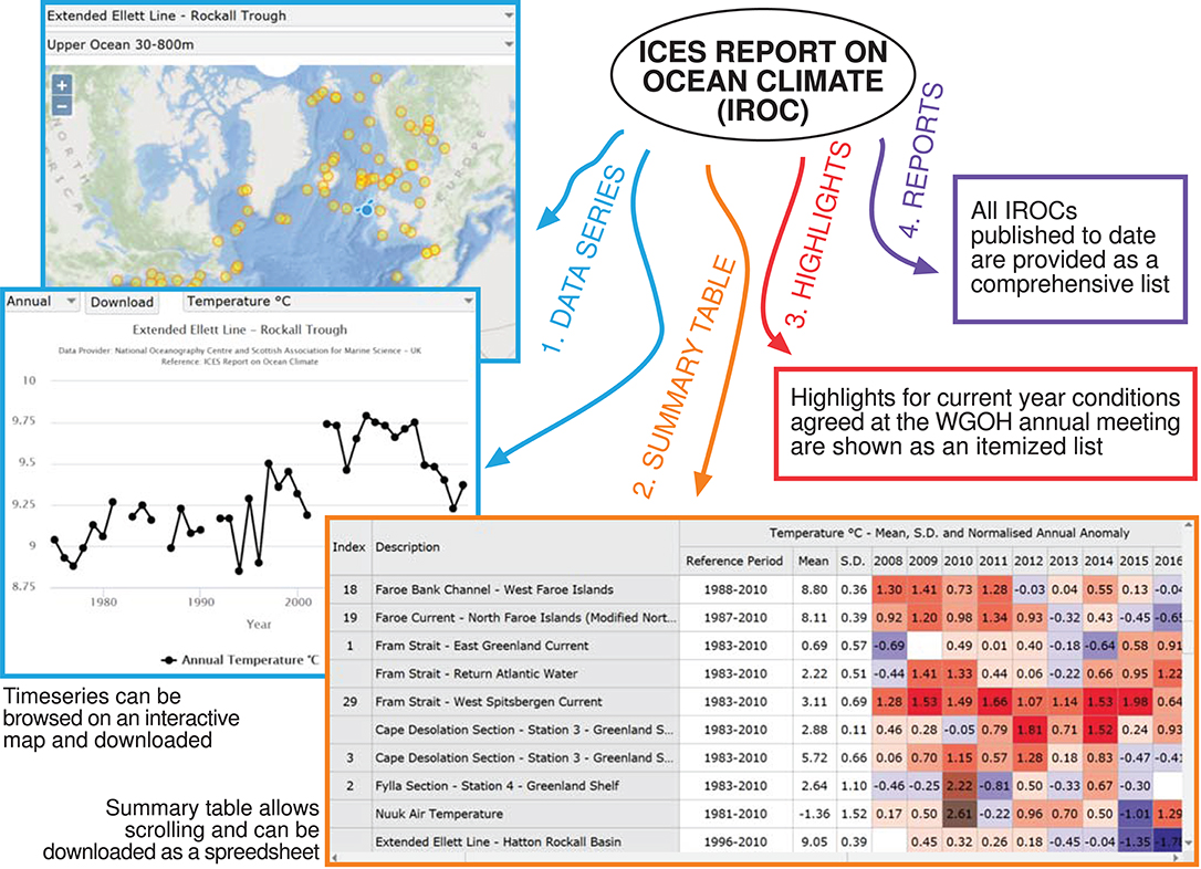
Figure 1. Composite of content provided by the web version of the IROC report as of 2018. The portal is organized into four tabs containing data and elaborated information.
WGOH analyses are based predominantly on existing repeated long-term in-situ hydrographic observations at stations and sections around the North Atlantic, the Nordic Seas and adjacent shelf seas, including the coastal, shelf and deep ocean. The idea behind the IROC is that regional experts perform analyses applying their specialized knowledge of a region to identify the most relevant available observational timeseries that support their assessment of hydrographic change. In this sense it is important to highlight that the IROC web is not a data repository but a heterogeneous collection of specialized timeseries. Most series are derived from CTDs deployed at fixed stations or along sections, with data extracted from either a single level or as vertical averages across a relevant water layer. Other series include long-term records of surface hydrography, sea-ice extent, atmospheric variables or other derived products such as heat content or estimated flows. Some of the timeseries reported in the IROC are the longest in the world and become more valuable to climate science with each passing year of continued measurement. These timeseries are not just long but also carefully analyzed by regional experts, thus of high quality to study and detect climate variability. Figure 2 shows some statistics of the current timeseries used for the IROC as of its latest published issue (González-Pola et al., 2018).
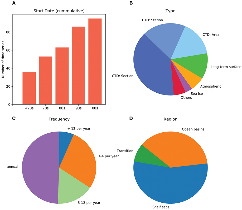
Figure 2. Basic properties of timeseries included in the IROC. The report currently includes 95 timeseries from 76 locations, provided by 32 organizations across 15 countries. (A) Histogram of the starting dates of the timeseries grouped by decade (cummulative), (B) timeseries type: where “others” accounts for modeled flow, heat content anomaly, fresh water anomaly and spatial extent of specific water masses (i.e., the Cold Intermediate Level), (C) timeseries sampling frequency, (D) oceanic region, where ‘Transition’ includes stations over continental slopes and within straits.
3. The WGOH and the Global Ocean Observing System
The WGOH has served as a network to physical oceanographers in the North Atlantic for decades. While most science emerging from the observational systems that feed the IROC are performed independently by WGOH members within their science groups, collaborative studies have also emerged (e.g., Holliday et al., 2008; Holt et al., 2012; Hughes et al., 2012; Mork et al., 2014). Besides science, most outreach is achieved through the production of the IROC, currently used as a quick guide to environmental conditions for assessments and in support of other scientific studies (e.g., Nøttestad et al., 2015; Punzón et al., 2016; Widmer et al., 2016; Townhill et al., 2017; Brander, 2018). To continue the success of the IROC, the WGOH is continually seeking new ways to engage with a burgeoning global ocean observing community and to distinguish the IROC in an increasingly crowded field of ocean status reports. Generally speaking, internal concerns deal with the role of the WGOH in the future world of global ocean observations.
3.1. Ocean Status Reports, End-User Needs and the Science-to-Policy Pathway
The need for continuous monitoring, systematic analysis and quick release of data and derived products is the foundation of what is known as operational oceanography. The aim of the oceanographic community has long been to follow the lead of the more advanced meteorological services, expecting that monitoring programs are coordinated and oceanographic data are gathered systematically using standardized procedures and are freely distributed as soon as possible. The GOOS program has managed to gather the efforts of several institutions/consortia in this direction.
Along with increasing data availability, gridded products and reanalysis have been used as a means of objectively synthesizing information, which can then be described in science-based reports that aim to provide easy-to-understand summaries to end users. The Intergovernmental Panel on Climate Change (IPCC) has been publishing global assessment reports every 5–8 years since 1990 (IPCC, 1990). Similarly, the National Oceanic and Atmospheric Administration (NOAA) has been publishing an annual State of the Climate report as a standalone peer-reviewed publication since 1996 (Halpert and Bell, 1997). Since 1994, the World Meteorological Organization (WMO) has published their annual Statement on the Global Climate (WMO, 1994). Over time, these three international flagship reports have introduced specific sections dedicated to the recent evolution of ocean climate, focusing on the ocean heat content, salinity, ocean circulation and more recently considering biogeochemistry. Current issues (IPCC, 2013; Hartfield et al., 2018; WMO, 2018) provide a high degree of detail in their ocean chapters. Region-specific ocean climate state reports are also being produced individually by countries either regularly or without predefined sequence.
In parallel to international efforts and those of individual countries, the European Union has developed Copernicus3 as a joint Earth Observation and Monitoring program built upon the in-situ observational capabilities of member states and satellite developments by the European Space Agency. Copernicus provides environmental services to the scientific community, policy-makers and general users. The Copernicus Marine Service has since 2016 released the Ocean State Report (von Schuckmann et al., 2018), dealing both with the Global Ocean and regional European Seas. Independent of Copernicus, the European Union has set the Marine Strategy Framework Directive4 (MSFD) as a legal framework to protect the marine environment from anthropogenic pressures across European waters. Contrary to large initiatives within GOOS in which sampling relies on voluntary efforts by institutions and countries, the MSFD enforces the establishment of (i) monitoring programs, (ii) objective environmental targets and (iii) a program of measures designed to achieve or maintain an objectively defined “Good Environmental Status”. Ocean Climate conditions are considered by the MSFD as an indirect anthropogenic pressure on the ocean environment, hence the monitoring of large-scale hydrographic conditions is a background prerequisite required for the MSFD as a whole. Interpretations on whether the MSFD enforces the development of specific large-scale monitoring programs for the background basic ocean variables have been varied (González et al., 2016).
As indicated, this profusion of ocean climate reporting raises concern about the current degree of complementarity and/or redundancy. Accordingly, the WGOH is concerned that the IROC remains relevant, distinguished in purpose and value to its users. The essential question, common to any report-producing team, is whether it is useful to end-users and if so how it should evolve to become more useful. Success requires a solid understanding of user needs. Sitting within the ICES, a body organized to encourage interdisciplinary networking, the WGOH-IROC is in a unique position to provide information and advice that is timely and relevant to the management of living marine resources. Oceanographic conditions are fundamental to understanding and predicting species distribution, forecasting recruitment, improving ecological models, etc. but marine ecology/fisheries scientists find it difficult to distinguish between available environmental products and effectively apply them to their work (ICES, 2018). The WGOH delivers expertise through the IROC and member engagement, which is becoming increasingly important as focus continues to shift toward ecosystem-based approaches for the management of marine resources (Dickey-Collas, 2014).
Several WGOH members are closely engaged with fisheries and environmental management activities, participating in multidisciplinary assessments and studies. In our experience, collaborators typically seek a succinct summary of the regional oceanography that can be used to frame a particular study, or a representative index of ocean variability that can be correlated with other measures of ecological change. In this sense, a simple representative timeseries or a few summarizing highlights are often sufficient. Hence, we expect the standard IROC user to focus on a specific region, while keeping in mind the general broader ocean context. A major strength of the IROC lies in the detailed regional analyses contributed by local experts from data products specifically tailored to the regional oceanography. Future developments of the IROC should not overlook this strength. Direct contact with potential users indicates that further developments may include a regional interpretation of available operational products and assessment of ocean state forecasts.
Along with improvements to the IROC, it is critical to develop a strategy for promoting its use, aimed at demonstrating the relevance of the report in future observing programs and its value for end-users. The current approach uses the ICES outreach strategy coordinated by a communications and publications department. IROC report highlights are published on the ICES news web page5 before publication of the full report, and extensive social network activity is triggered along the process. A major target in the WGOH is having the report ready in summer to facilitate its use at the ICES Annual Science Conference. In parallel to ICES efforts, WGOH members use their own science networks and conference attendances to promote the IROC. Future success of the IROC will be tracked through its bibliometric performance, with the recent introduction of digital identifiers (doi) in Cooperative Research Reports.
ICES' goal of providing unbiased science-based advice to competent authorities requires full involvement of all EGs in the science-to policy pathway. The transfer of scientific advances into practical management tools builds upon the underlying idea that permanent two-way communication and strong coordination are pivotal. Current ICES structure relies on two main pillars, the Science and the Advisory Committees, who jointly struggle to facilitate such coordination6. WGOH-IROC forms a critical bridge between data collected by independent scientists/institutions/countries for research and environmental monitoring, and actual policy advice.
3.2. IROC Timeseries and GOOS
As seen in section 2, the WGOH analyses reported in the IROC are mostly based on the existence of long-term high-quality repeat hydrographic timeseries, primarily derived from in-situ sampling. These timeseries are considered representative at regional scale, providing notable coverage of the shelf seas and ocean boundaries. Traditional in-situ sampling was the only option for most of the twentieth century but the last two decades have yielded outstanding advances in routine automated sampling of the ocean in terms of oceanographic fixed buoys (WMO-IOC, 2018), the Argo array (Riser et al., 2016) and more recently regular glider missions (Rudnick, 2016).
The introduction of new technology will allow for the continuation of several long-established timeseries in the North Atlantic. A relevant case is the Ellett Line (Holliday and Cunningham, 2013), that started in 1975 and has been covered by an annual cruise until now. Beginning in 2018 this regular cruise will be superseded by a new observation system (OSNAP7) utilizing moored arrays, glider missions and biannual shipboard sampling. The representative regional IROC timeseries will be continued using these data supplemented by observations from the Argo array. In another example, high-frequency subsurface sampling by the Norwegian Ocean Weather Station “M” was discontinued with the removal of the last weather ship in 2010 (Yelland et al., 2009). As a replacement, hydrographic observations from this location derive now from subsurface instrumentation in the framework of OceanSITES8 plus research ships visits up to five-six times per year. Finally, surface temperature measurements collected via ship of opportunity at 52°N along the southern North Sea were discontinued in 2002 with the removal of the ferry line. However, the timeseries may now continue using observations from a nearby Smartbuoy (See Figure 77, p.81, in González-Pola et al., 2018).
Currently, only a portion of the IROC timeseries are systematically being incorporated into Global Operational Databases and hence contributing effectively to GOOS. This issue is a major concern of the WGOH, already highlighted in the previous white paper authored by the group (Holliday et al., 2010). One challenge is that most hydrography derived from national monitoring programs are only available in delayed mode, while current demands expect real-time availability. In addition, many repeat hydrography programs do not meet the GO-SHIP9 sampling criteria and hence datasets are not incorporated through JCOMMOPS10. The lack of a home for classical hydrographic cruises has been highlighted as a weakness of the current JCOMMOPS structure. On the other hand, the ICES Data Center has long focused on hosting delayed mode CTD and discrete water bottle data from ICES areas, which are routinely incorporated into the US World Ocean Database and Atlas11 and made available to the global community.
As automated sampling develops, science programs are beginning to consider the relative benefits of more traditional in-situ sampling. Oceanographic cruises are becoming more multidisciplinary, with biogeochemistry often included as a mandatory component, while hydrography stands as a basic record. Further, in-situ hydrography remains essential for the groundtruthing of data from autonomous vehicles and profiling floats. Hence, while autonomous systems may supplement in-situ measurements made via ship or moored array in long-standing programs, we argue that these traditional observations will be required well into the future. Despite the delayed delivery, IROC timeseries offer significant added value to GOOS programs. In particular, (i) IROC observations sample the deep ocean in a variety of locations across the North Atlantic, filling a major gap in present day GOOS where deep observations (>2000m) are limited to GO-SHIP sections (Deep Argo floats and deep gliders still have a long way to fully cover the gap) and (ii) IROC observations bridge a gap between the blue ocean and regional seas, shelves and oceanic boundaries, where most classical monitoring programs take place but the Argo network cannot access.
4. Conclusion and Outlook
For decades, the ICES-WGOH has provided ICES and the oceanographic community with information on the condition of the North Atlantic Ocean by updating and reviewing results from standard long-standing hydrographic sections and stations. WGOH continues a long tradition of international collaboration, bringing together physical oceanographers with regional expertise and a rich collection of ocean data to contribute to this annual assessment. While global ocean observation has evolved in the past decade, greatly increasing in volume and complexity, the WGOH-IROC continues to be a key link between regional ocean monitoring and research, and actual policy advice. Looking toward the future, ICES-WGOH has much to offer the burgeoning GOOS community, including a history of observations in key areas of the ocean and experience in meeting the needs of fisheries scientists. However, further engagement with GOOS is essential. WGOH will continue to track key observational timeseries, stressing continuity and quality while working to incorporate these data into the GOOS system.
Data Availability
The datasets analyzed for the IROC discussed in this white paper can be downloaded at the IROC online web page https://ocean.ices.dk/iroc/
Author Contributions
CG-P conceived the white paper and coordinated the group. CG-P, PF, KL, and NH designed the paper structure and defined the key contents. CG-P took the lead in writing the manuscript and PF performed thorough draft reviews. RG analyzed the characteristics of the collection of timeseries and created a graphical representation of the outcome. All authors commented on the manuscript providing specific feedback.
Funding
The work carried out over the years by the WGOH under the auspices of ICES is supported by many monitoring programs across the North Atlantic and Arctic regions, either run by working group members hosting institutions or other institutions/consortia. WGOH work and meetings are possible through the economical commitment of ICES member countries.
Conflict of Interest Statement
The authors declare that the research was conducted in the absence of any commercial or financial relationships that could be construed as a potential conflict of interest.
Acknowledgments
The authors wish to thank ICES for promoting international networking through expert groups, WGOH members hosting institutions for sponsoring their active participation in the Working Group and all institutions/projects/people behind the IROC timeseries collection.
Footnotes
1. ^from www.ices.dk/explore-us/what-we-do/Pages/default.aspx
2. ^https://ocean.ices.dk/iroc/
4. ^http://ec.europa.eu/environment/marine/eu-coast-and-marine-policy/marine-strategy-framework-directive
5. ^www.ices.dk/news-and-events/news-archive/news/Pages/Ocean-climate-highlights.aspx
6. ^www.ices.dk/community/groups/Pages/wkscience2advice.aspx—Workshop on translating science into advice. 2018.
7. ^The Overturning in the Subpolar North Atlantic Program www.o-snap.org
9. ^The Global Ocean Ship-Based Hydrographic Investigations Program www.go-ship.org/DatReq.html
10. ^WMO-IOC Joint Technical Commission for Oceanography and Marine Meteorology in-situ Observing Programmes Support Centre www.jcommops.org
References
Berx, B., and Payne, M. R. (2017). The Sub-Polar Gyre Index - a community data set for application in fisheries and environment research. Earth Syst. Sci. Data 9, 259–266. doi: 10.5194/essd-9-259-2017
Brander, K. M. (2018). Climate change not to blame for cod population decline. Nat. Sustainabil. 1, 262–264. doi: 10.1038/s41893-018-0081-5
Dickey-Collas, M. (2014). Why the complex nature of integrated ecosystem assessments requires a flexible and adaptive approach. J. Mar. Sci. 71, 1174–1182. doi: 10.1093/icesjms/fsu027
Gaillard, F., Reynaud, T., Thierry, V., Kolodziejczyk, N., and von Schuckmann, K. (2016). In situ–based reanalysis of the global ocean temperature and salinity with ISAS: Variability of the heat content and steric height. J. Clim. 29, 1305–1323. doi: 10.1175/jcli-d-15-0028.1
González, D., Coughlan, C., Stipsand, A., Stolkand, A., González-Pola, C., Moreno-Aranda, I., et al. (2016). Review of the Commission Decision 2010/477/EU concerning MSFD criteria for assessing Good Environmental Status, Descriptor 7. Joint Research Centre Technical Reports, EUR 27544 EN. doi: 10.2788/435059
González-Pola, C., Larsen, K., Fratantoni, P., Beszczynska-Möller, (eds.). (2018). ICES Report on Ocean Climate 2017. ICES Cooperative Research Report No. 345. doi: 10.17895/ices.pub.4625
Halpert, M. S., and Bell, G. D. (1997). Climate assessment for 1996. Bull. Am. Meteorol. Soc. 78, S1–S50. doi: 10.1175/1520-0477-78.5s.s1
Hartfield, G., Blunden, J., and Arndt, D. S. (2018). State of the climate in 2017. Bull. Am. Meteorol. Soc. 99, Si–S310. doi: 10.1175/2018bamsstateoftheclimate.1
Hátún, H., and Chafik, L. (2018). On the recent ambiguity of the North Atlantic Subpolar Gyre Index. J. Geophys. Res. Oceans 123, 5072–5076. doi: 10.1029/2018JC014101
Holliday, N. P., and Cunningham, S. A. (2013). The extended Ellett Line: discoveries from 65 years of marine observations west of the UK. Oceanography 26, 156–163. doi: 10.5670/oceanog.2013.17
Holliday, N. P., Hughes, S. L., Bacon, S., Beszczynska-Möller, A., Hansen, B., et al. (2008). Reversal of the 1960s to 1990s freshening trend in the northeast North Atlantic and Nordic Seas. Geophys. Res. Lett. 35:L03614. doi: 10.1029/2007GL032675
Holliday, N. P., Valdimarsson, H., Nolan, G., Hughes, S., Lavín, A., Østerhus, S., et al. (2010). “The ICES Working Group on Oceanic Hydrography: building on over 100 years of North Atlantic observations,” in Proceedings of OceanObs' 09: Sustained Ocean Observations and Information for Society, Venice, Vol. 2, eds J. Hall, D. Harrison, and D. Stammer (Noordwijk: European Space Agency), 501–507.
Holt, J., Hughes, S., Hopkins, J., Wakelin, S. L., Holliday, N. P., Dye, S., et al. (2012). Multi-decadal variability and trends in the temperature of the northwest European continental shelf: A model-data synthesis. Progr. Oceanogr. 106, 96–117. doi: 10.1016/j.pocean.2012.08.001
Hughes, S., Holliday, N., editors (2006). ICES Report on Ocean Climate 2005. ICES Cooperative Research Report No. 280.
Hughes, S., Lavín, A., (eds.). (2004). The Annual ICES Ocean Climate Status Summary 2003/2004. ICES Cooperative Research Report No. 269.
Hughes, S. L., Holliday, N. P., and Gaillard, F. (2012). Variability in the ICES/NAFO region between 1950 and 2009: observations from the ICES Report on Ocean Climate. J. Mar. Sci. 69, 706–719. doi: 10.1093/icesjms/fss044
ICES (2018). WGCHAIRS, 23-25 January 2018. ICES CM 2018/ACOM/SCICOM:01. ICES Headquarters, Copenhagen.
IPCC (1990). Climate Change: The IPCC Scientific Assessment. Report prepared for Intergovernmental Panel on Climate Change by Working Group I. Cambridge, New York, NY; Melbourne, VIC: Cambridge University Press.
IPCC (2013). Climate Change 2013: The Physical Science Basis. Contribution of Working Group I to the Fifth Assessment Report of the Intergovernmental Panel on Climate Change. Cambridge; New York, NY: Cambridge University Press. doi: 10.1017/CBO9781107415324
Mork, K. A., Skagseth, Ø., Ivshin, V., Ozhigin, V., Hughes, S. L., and Valdimarsson, H. (2014). Advective and atmospheric forced changes in heat and fresh water content in the Norwegian Sea, 1951-2010. Geophys. Res. Lett. 41, 6221–6228. doi: 10.1002/2014gl061038
Nøttestad, L., Krafft, B. A., Anthonypillai, V., Bernasconi, M., Langård, L., Mørk, H. L., et al. (2015). Recent changes in distribution and relative abundance of cetaceans in the Norwegian Sea and their relationship with potential prey. Front. Ecol. Evol. 2:83. doi: 10.3389/fevo.2014.00083
Punzón, A., Serrano, A., Sánchez, F., Velasco, F., Preciado, I., González-Irusta, J., et al. (2016). Response of a temperate demersal fish community to global warming. J. Mar. Syst. 161, 1–10. doi: 10.1016/j.jmarsys.2016.05.001
Riser, S. C., Freeland, H. J., Roemmich, D., Wijffels, S., Troisi, A., Belbéoch, M., et al. (2016). Fifteen years of ocean observations with the global Argo array. Nat. Clim. Change 6, 145–153. doi: 10.1038/nclimate2872
Rudnick, D. L. (2016). Ocean research enabled by underwater gliders. Ann. Rev. Mar. Sci. 8, 519–541. doi: 10.1146/annurev-marine-122414-033913
Townhill, B., Pinnegar, J., Tinker, J., Jones, M., Simpson, S., Stebbing, P., et al. (2017). Non-native marine species in north-west Europe: developing an approach to assess future spread using regional downscaled climate projections. Aquat. Conserv. 27, 1035–1050. doi: 10.1002/aqc.2764
Turrel, B. (ed.). (1999). The 1998/1999 ICES Annual Ocean Climate Status Summary. Annex S. in Report from the Working Group on Ocean Hydrography (WGOH) 1998, ICES CM 1999/C:8.
von Schuckmann, K., Traon, P.-Y. L., Smith, N., Pascual, A., Brasseur, P., Fennel, K., et al. (2018). Copernicus Marine Service Ocean State Report. Journal of Operational Oceanography, 11(sup1):S1–S142. doi: 10.1080/1755876x.2018.1489208
Widmer, C., Fox, C., and Brierley, A. (2016). Effects of temperature and salinity on four species of northeastern Atlantic scyphistomae (Cnidaria: Scyphozoa). Mar. Ecol. Progr. Ser. 559, 73–88. doi: 10.3354/meps11879
WMO-IOC (2018). Global Data buoy Observations, a DBCP Implementation Strategy, Fifteenth Edition. Technical report, Document No. 15, Geneva.
Keywords: ocean climate, hydrography, timeseries, in-situ sampling, periodical report, science to policy, North Atlantic
Citation: González-Pola C, Fratantoni P, Larsen KMH, Holliday NP, Dye S, Mork KA, Beszczynska-Möller A, Valdimarsson H, Trofimov A, Parner H, Klein H, Cisewski B, Fontán A, Lyons K, Kolodziejczyk N, Graña R, Linders J, Wodzinowski T, Goszczko I and Cusack C (2019) The ICES Working Group on Oceanic Hydrography: A Bridge From In-situ Sampling to the Remote Autonomous Observation Era. Front. Mar. Sci. 6:103. doi: 10.3389/fmars.2019.00103
Received: 31 October 2018; Accepted: 20 February 2019;
Published: 19 March 2019.
Edited by:
Sanae Chiba, Japan Agency for Marine-Earth Science and Technology, JapanReviewed by:
Christoph Waldmann, University of Bremen, GermanyOscar Schofield, Rutgers University, United States
Copyright © 2019 González-Pola, Fratantoni, Larsen, Holliday, Dye, Mork, Beszczynska-Möller, Valdimarsson, Trofimov, Parner, Klein, Cisewski, Fontán, Lyons, Kolodziejczyk, Graña, Linders, Wodzinowski, Goszczko and Cusack. This is an open-access article distributed under the terms of the Creative Commons Attribution License (CC BY). The use, distribution or reproduction in other forums is permitted, provided the original author(s) and the copyright owner(s) are credited and that the original publication in this journal is cited, in accordance with accepted academic practice. No use, distribution or reproduction is permitted which does not comply with these terms.
*Correspondence: César González-Pola, cesar.pola@ieo.es