A Sustained Ocean Observing System in the Indian Ocean for Climate Related Scientific Knowledge and Societal Needs
 J. C. Hermes1,2*
  Y. Masumoto3,4
  L. M. Beal5
  M. K. Roxy6,7 J. Vialard8 M. Andres9 H. Annamalai10 S. Behera4 N. D’Adamo11
  T. Doi4
  M. Feng12 W. Han13
  N. Hardman-Mountford14 H. Hendon15
  R. Hood16
  S. Kido3 C. Lee17
  T. Lee18 M. Lengaigne8
  J. Li19
  R. Lumpkin20 K. N. Navaneeth21
  B. Milligan22
  M. J. McPhaden7
  M. Ravichandran23
  T. Shinoda24
  A. Singh25
  B. Sloyan12
  P. G. Strutton26,27
  A. C. Subramanian28
  S. Thurston18
  T. Tozuka3
  C. C. Ummenhofer9
  A. S. Unnikrishnan29
  R. Venkatesan21
  D. Wang30 J. Wiggert31
  L. Yu9
  W. Yu32
- 1Egagasini Node, The South African Environmental Observation Network, Cape Town, South Africa
- 2Department of Oceanography, University of Cape Town, Cape Town, South Africa
- 3Department of Earth and Planetary Science, Graduate School of Science, The University of Tokyo, Tokyo, Japan
- 4Application Laboratory, Japan Agency for Marine-Earth Science and Technology, Yokosuka, Japan
- 5Rosenstiel School of Marine and Atmospheric Science, University of Miami, Miami, FL, United States
- 6Indian Institute of Tropical Meteorology, Pune, India
- 7Pacific Marine Environmental Laboratory (NOAA), Seattle, WA, United States
- 8Sorbonne Universités (UPMC, Univ Paris 06)-CNRS-IRD-MNHN, LOCEAN Laboratory, IPSL, Paris, France
- 9Department of Physical Oceanography, Woods Hole Oceanographic Institution, Woods Hole, MA, United States
- 10International Pacific Research Center, University of Hawaii, Honolulu, HI, United States
- 11Intergovernmental Oceanographic Commission of UNESCO (IOC-UNESCO), Paris, France
- 12Commonwealth Scientific and Industrial Research Organisation (CSIRO), Oceans and Atmosphere, Centre for Southern Hemisphere Oceans Research, Hobart, TAS, Australia
- 13Department of Atmospheric and Oceanic Sciences, University of Colorado, Boulder, Boulder, CO, United States
- 14Trade, Oceans and Natural Resources, Commonwealth Secretariat, London, United Kingdom
- 15Bureau of Meteorology, Melbourne, VIC, Australia
- 16Center for Environmental Science, University of Maryland, Cambridge, MD, United States
- 17Applied Physics Laboratory, University of Washington, Seattle, WA, United States
- 18Jet Propulsion Laboratory, NASA, Washington, DC, United States
- 19International CLIVAR Project Office (ICPO), Qingdao, China
- 20Atlantic Oceanographic and Meteorological Laboratory (NOAA), Miami, FL, United States
- 21National Institute of Ocean Technology, Chennai, India
- 22Faculty of Law, University of New South Wales, Sydney, NSW, Australia
- 23National Centre for Antarctic and Ocean Research, Goa, India
- 24Department of Physical and Environmental Sciences, Texas A&M University–Corpus Christi, Corpus Christi, TX, United States
- 25Physical Research Laboratory, Ahmedabad, India
- 26Institute for Marine and Antarctic Studies, University of Tasmania, Hobart, TAS, Australia
- 27Australian Research Council Centre of Excellence for Climate Extremes, University of Tasmania, Hobart, TAS, Australia
- 28Scripps Institution of Oceanography, University of California, San Diego, La Jolla, CA, United States
- 29National Institute of Oceanography (CSIR), Dona Paula, India
- 30South China Sea Institute of Oceanology (CAS), Guangzhou, China
- 31Division of Marine Science, The University of Southern Mississippi, John C. Stennis Space Center, Hancock County, MS, United States
- 32First Institute of Oceanography, State Oceanic Administration, Qingdao, China
The Indian Ocean is warming faster than any of the global oceans and its climate is uniquely driven by the presence of a landmass at low latitudes, which causes monsoonal winds and reversing currents. The food, water, and energy security in the Indian Ocean rim countries and islands are intrinsically tied to its climate, with marine environmental goods and services, as well as trade within the basin, underpinning their economies. Hence, there are a range of societal needs for Indian Ocean observation arising from the influence of regional phenomena and climate change on, for instance, marine ecosystems, monsoon rains, and sea-level. The Indian Ocean Observing System (IndOOS), is a sustained observing system that monitors basin-scale ocean-atmosphere conditions, while providing flexibility in terms of emerging technologies and scientificand societal needs, and a framework for more regional and coastal monitoring. This paper reviews the societal and scientific motivations, current status, and future directions of IndOOS, while also discussing the need for enhanced coastal, shelf, and regional observations. The challenges of sustainability and implementation are also addressed, including capacity building, best practices, and integration of resources. The utility of IndOOS ultimately depends on the identification of, and engagement with, end-users and decision-makers and on the practical accessibility and transparency of data for a range of products and for decision-making processes. Therefore we highlight current progress, issues and challenges related to end user engagement with IndOOS, as well as the needs of the data assimilation and modeling communities. Knowledge of the status of the Indian Ocean climate and ecosystems and predictability of its future, depends on a wide range of socio-economic and environmental data, a significant part of which is provided by IndOOS.
Overview of the Indian Ocean
Unique Features of the Indian Ocean
The Indian Ocean has many unique features, largely due to the vast Asian landmass to the north (Figure 1) and a low latitude throughflow from the Pacific via the Indonesian Seas (e.g., Gordon et al., 2010). The Asian monsoon winds drive a complete reversal of the currents north of 10°S (Figure 1) (e.g., Schott and McCreary, 2001), including the Somali Current at the western boundary and semi-annual jets (Wyrtki, 1973) along the equator. The strong southwest monsoon winds yield intense upwelling along the western boundary of the Arabian Sea during boreal summer (Figure 1), modulating evaporation and moisture transport toward India (Izumo et al., 2008), providing a globally significant source of atmospheric CO2, and fostering intense oceanic productivity. This high productivity, together with low ventilation, leads to a subsurface depletion of oxygen (oxygen minimum zone, OMZ) that is now expanding and has already led to a dramatic shift in the Arabian Sea and Bay of Bengal ecosystem (Gomes et al., 2014; Bristow et al., 2017). Excess freshwater input from monsoon rain and river runoff generates strong saline stratification in the Bay of Bengal, inhibiting mixing and influencing oceanic productivity (Prasanna Kumar et al., 2002) and sea surface temperature (SST), which in turn regulate regional climate (Shenoi et al., 2002) and weather extremes (Neetu et al., 2019).
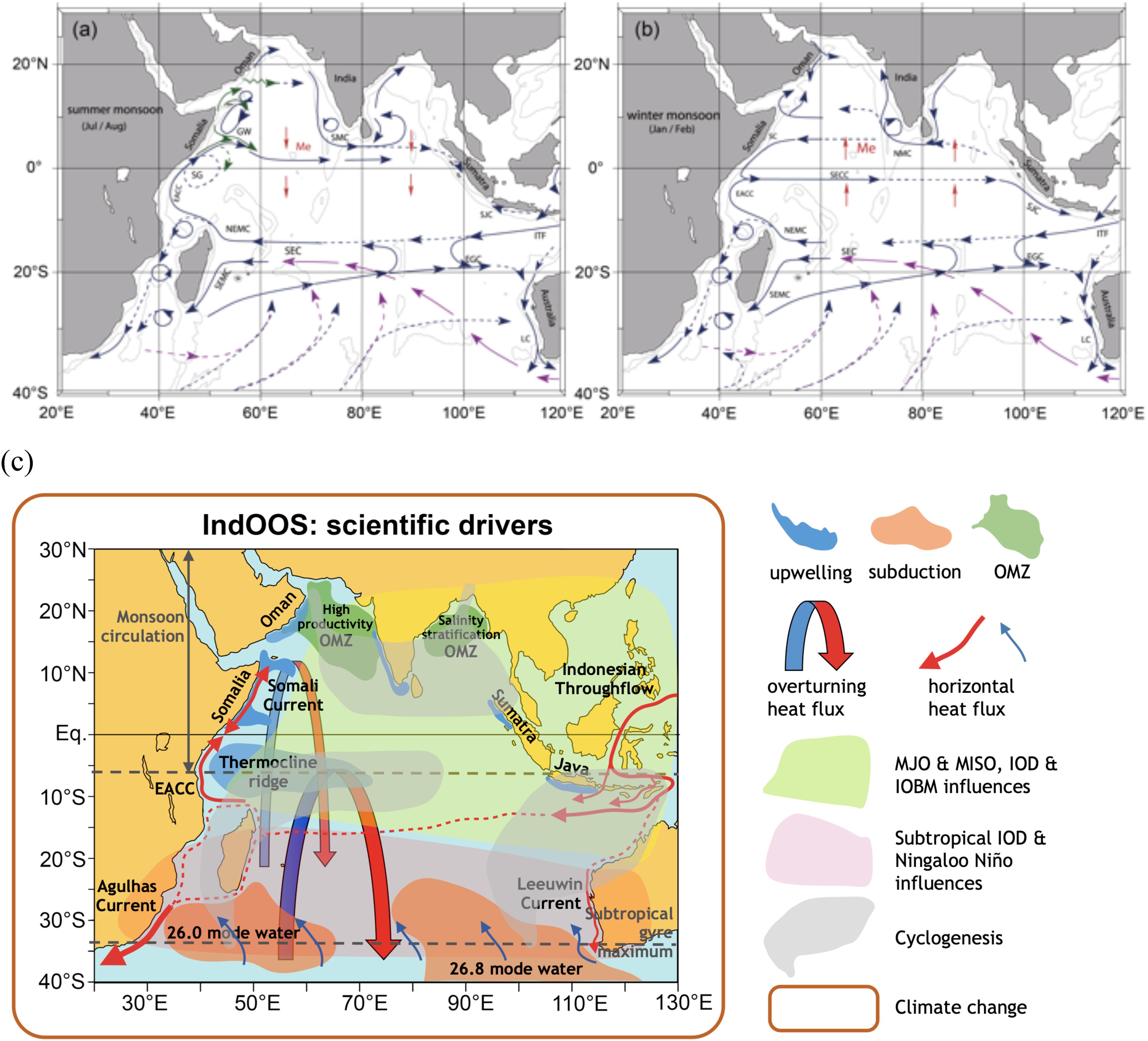
Figure 1. Indian Ocean basin circulations during (a) boreal summer monsoon and (b) boreal winter monsoon (Schott et al., 2009). (c) Schematic view of key phenomena in the Indian Ocean (from the IndOOS decadal review led by IORP, to be published in 2019).
The Indian Ocean receives excess heat from the atmosphere and via the Indonesian Throughflow (ITF; Sprintall et al., 2014) and this is exported to the Atlantic and Southern Oceans via an ocean gyre circulation and an upper-ocean overturning cell (Ganachaud and Wunsch, 2000; Lumpkin and Speer, 2007; Hernández-Guerra and Talley, 2016), which are thought to be strongly constrained by the Agulhas Current at the western boundary (Bryden and Beal, 2001).
A large part of the low latitude Indian Ocean is covered by surface water warmer than 28°C, where deep atmospheric convection is maintained (e.g., Graham and Barnett, 1987) and the global atmospheric circulation cell, the Walker Circulation, is energized. Deep atmospheric convection is modulated by the Madden–Julian Oscillation (MJO) and by the monsoon intraseasonal oscillation (MISO), which induce subseasonal air–sea interactions (DeMott et al., 2015). The western tropical Indian Ocean, around 5–10°S, is a particularly important region for air–sea coupling. The thermocline ridge (Figure 1), associated with off-equatorial upwelling of the shallow overturning circulation, makes the SST there highly sensitive to atmospheric anomalies, which in turn impact the cyclogenesis and MJO development (e.g., Vialard et al., 2009).
At interannual time scales, the tropical Indian Ocean exhibits uniform warming during and after El Niño events (e.g., Xie et al., 2009), a response known as the Indian Ocean Basin Mode (IOBM). The Indian Ocean also has important interannual climate modes of its own, such as the Indian Ocean Dipole (IOD; Saji et al., 1999; Webster et al., 1999). In its positive phase, cold SSTs near Java-Sumatra, warm temperatures in the western tropical Indian Ocean thermocline ridge, and anomalous easterly winds near the equator induce various impacts like droughts in Indonesia and Australia and floods over eastern Africa (e.g., Yamagata et al., 2004). The Indian Ocean is also home to subtropical climate modes, such as the Subtropical Indian Ocean Dipole (SIOD) which manifests as large-scale SST anomalies spanning 15–45°S, with strong influence on South African rainfall (Reason, 2001).
The Indian Ocean is the only ocean with a poleward flowing boundary current on the eastern side of a subtropical gyre – the Leeuwin Current off Western Australia – giving rise to a unique ecology (Waite et al., 2007). Climate variability develops under the form of Ningaloo Niño events, intense marine heatwaves, which affect local fisheries and rainfall over neighboring Western Australia (Feng et al., 2013, 2015).
Due to paucity of observations, little is known about the decadal variations in the Indian Ocean (Han et al., 2014), which makes it difficult to distinguish climate change trends from patterns of natural variability (e.g., Carson et al., 2015). Even less is known about the changing biogeochemistry and higher trophic levels of the Indian Ocean at these time scales (Singh and Ramesh, 2015). There is, however, no doubt that the Indian Ocean is responding to anthropogenic climate change, with evidence of increasing SSTs and heat content, rising sea level, increased carbon and nitrogen uptake, and an intensified water cycle (Intergovernmental Panel on Climate Change [IPCC], 2013; Han et al., 2014; Kumar et al., 2018).
Societal Needs for Observing Systems
The Indian Ocean basin is surrounded by 22 countries, which contain almost one third of mankind, many of which are vulnerable to extreme weather events and climate change. These rim countries depend on rain-fed agriculture, which is tightly linked to monsoon rainfall. Indian Ocean SSTs have been shown to influence these monsoon rains, as well as flooding in east African countries (Saji et al., 1999; Webster et al., 1999; Roxy et al., 2016), and droughts and wildfires in Indonesia (Abram et al., 2003; D’Arrigo and Wilson, 2008) and Australia (Ashok et al., 2003; Ummenhofer et al., 2009).
Although the Indian Ocean is the smallest of the world’s major oceans, it has accounted for more than one quarter of global ocean heat gain over the last 20 years (Lee et al., 2015; Cheng et al., 2016) and perhaps as much as 45% over the upper 700 m in the last 10 years (Desbruyères et al., 2017). This rapid warming (Roxy et al., 2016) is linked to decreasing rainfall over eastern Africa, which is predicted to increase the number of undernourished people in this region by 50% by 2030 (Funk et al., 2008).
Oceanic heat content and its distribution also influences winds, rainfall, storm intensity, and sea level rise (Han et al., 2014) and can influence fisheries and marine ecosystems due to associated changes in stratification, oxygen, and nutrient levels (Roxy et al., 2016). Many of the rim countries depend on fisheries for their livelihood, but the intense marine productivity is highly vulnerable to projected climate change (Allison et al., 2009; Kaur-Kahlon et al., 2016; Roxy et al., 2016; Kumar et al., 2018), such as changes in the monsoon winds and hence upwelling, as well as the expanding OMZ (e.g., Naqvi et al., 2010).
Beyond its direct impact on rim countries, the Indian Ocean influences climate globally. The basin accounts for about one fifth of the global oceanic uptake of anthropogenic CO2 (Takahashi et al., 2002), helping to buffer the effects of global warming. It is the breeding ground for the MJO, which modulates rainfall and tropical cyclone activity across most of the tropics (Zhang, 2005). In addition to this, year to year temperature variations associated with the Indian Ocean influence the evolution of the El Niño Southern Oscillation (ENSO) in the Pacific Ocean (e.g., Clarke and Van Gorder, 2003; Izumo et al., 2010; Luo et al., 2010; Terray et al., 2015).
The Indian Ocean is also a tropical-subtropical gateway from the Pacific to the Atlantic Ocean, as part of the global “conveyor belt” (Broecker, 1991), regulating and redistributing heat within the global ocean. The Indian Ocean surface warming trend has far reaching impacts, modulating Pacific (e.g., Luo et al., 2012; Hamlington et al., 2014; Han et al., 2014; Dong and McPhaden, 2017; Cai et al., 2019) and North Atlantic climate (e.g., Hoerling et al., 2004) and causing droughts in the West Sahel and Mediterranean (e.g., Giannini et al., 2003; Hoerling et al., 2012).
Indian Ocean Observing System (IndOOS)
Indian Ocean Observing System emerged from discussions at the first OceanObs meeting in 1999, a time of new and advancing observing technologies, such as profiling floats (Argo), satellite missions, and surface meteorological buoys. Based on scientific and societal needs, an implementation plan for IndOOS was put together by the Indian Ocean Panel (now the Indian Ocean Regional Panel, IORP) in 2006, established under the Climate and Ocean Variability, Predictability, and Change (CLIVAR) and Global Ocean Observing System (GOOS) programs. The goal of IndOOS is to provide sustained high-quality oceanographic and marine meteorological measurements to support knowledge based decision-making through improved scientific understanding, weather and climate forecasts, and environmental assessments for the benefit of society. Observing system simulation experiments (OSSE) for the moored array, the Argo network, and the eXpendable Bathy Thermograph (XBT) network were conducted for the original IndOOS design (Ballabrera-Poy et al., 2007; Oke and Schiller, 2007; Vecchi and Harrison, 2007), providing justifications for measurement locations and sampling frequency.
A few years later, in a white paper for OceanObs’09, Masumoto et al. (2010) noted two priorities for IndOOS: Completion of the moored tropical array (Research Moored Array for African-Asian-Australian Monsoon Analysis and prediction, RAMA), which was then 47% complete, and attainment of the necessary resources to sustain IndOOS. Other noted needs were to improve coordination across platforms and regional and basin scale programs, improve data and product distribution, and enhance capacity development in Indian Ocean rim countries. As a result of these recommendations the IndOOS Resources Forum (IRF) and Sustained Indian Ocean Biogeochemistry and Ecosystem Research (SIBER) panel were formed.
Current State of IndOOS
IndOOS (Figure 2a) comprises of five in situ observing networks: RAMA, profiling floats (Argo program), surface drifters (Global Drifter Program, GDP), repeat temperature lines (XBT network), and tide gauges. Augmenting these networks are remotely sensed observations of surface winds, sea level, SST and salinity, rainfall, and ocean color, as well as a coarse network of decadal hydrographic survey lines (The Global Ocean Ship-Based Hydrographic Investigations Program, GO-SHIP).
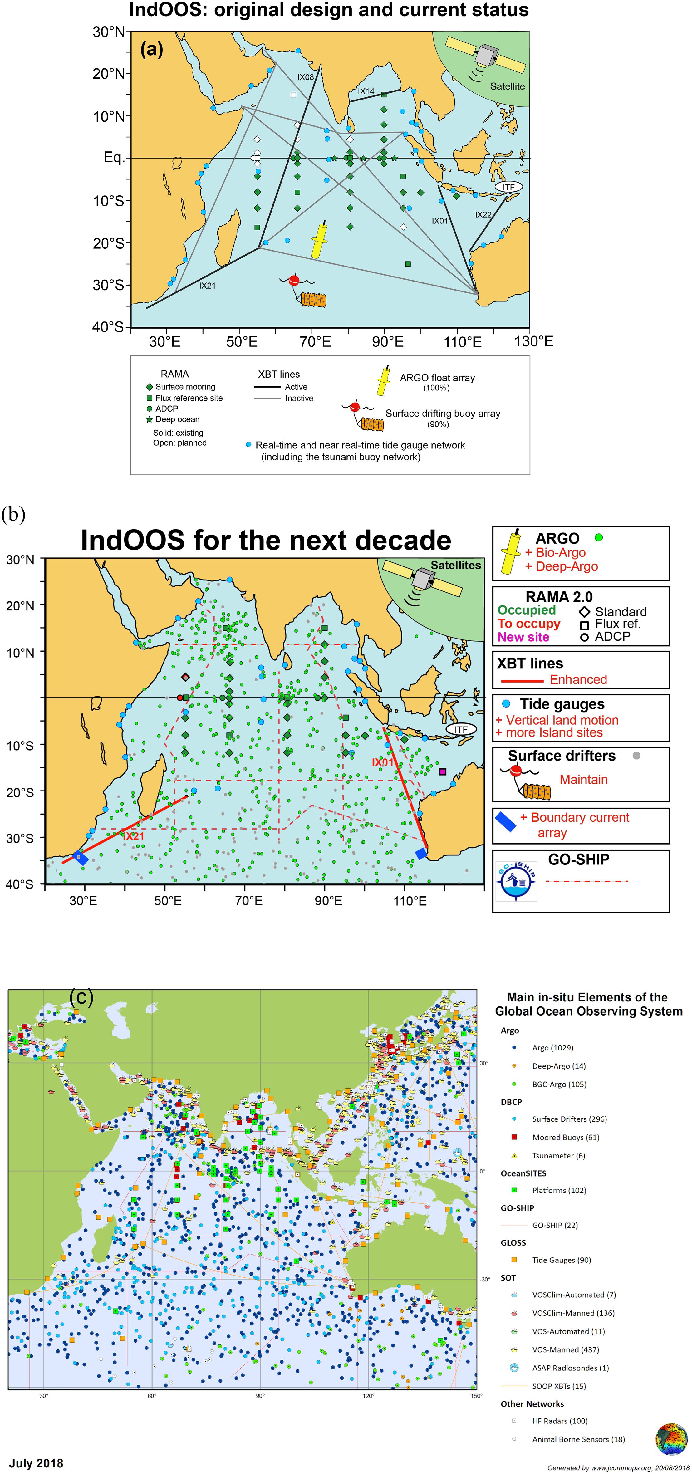
Figure 2. (a) IndOOS original design and current status. The original IndOOS design comprises the RAMA, Argo, XBT network, surface drifting buoys, and tide gauge components. (b) The proposed evolution of IndOOS (from the IndOOS decadal review led by IORP, to be published in 2019). (c) Current state of IndOOS, as on July 2018 (from JCOMM OPS webpage at http://www.jcommops.org/board. Note that the numbers indicated includes the buoys and floats not only in the Indian Ocean but also in the South China Sea and a part of the western Pacific Ocean).
RAMA is a centerpiece of the observing network (McPhaden et al., 2009) and followed early pilot programs by Japan and India to deploy current meter moorings along the equator. Thereafter, United States, Indonesia, China, Australia, and the United Nations, through two international large marine ecosystem programs (Agulhas Somali Large Marine Ecosystem and Bay of Bengal Large Marine Ecosystem), have jointly implemented and maintained RAMA. As part of a recent decadal review of the IndOOS, the array has been redesigned (RAMA-2.0) and is now 91% complete (c.f., Figures 2a,b), with the establishment of new sites in the Arabian Sea under United States–India collaboration. Efforts are also underway to integrate within the RAMA framework an additional eight Indian moorings of the Ocean Moored Buoy Network (OMNI) that are outside the Indian exclusive economic zone (EEZ). RAMA provides hourly and daily averaged time series of key oceanographic and surface meteorological variables in real-time1. These measurements help us understand the broad range of times scales, from diurnal to decadal, that affect weather and climate variability and are especially valuable for studies of ocean–atmosphere interactions associated with the MJO and MISO. Data from the RAMA moorings are made available to operational weather and climate prediction centers around the world through the Global Telecommunications System (GTS), providing essential input for weather and seasonal forecast models.
The Argo network is global (Gould et al., 2004), consisting of one autonomous profiler per 3° × 3° region, each profiling the ocean (temperature, salinity, and pressure) down to 2000 m every 10 days. Design coverage is 450 floats in the Indian Ocean north of 40°S and was first achieved in 2008. Argo has become the primary data source for understanding variability and trends within the ocean, such as the increase in ocean heat content and the persistence of marine heat waves – phenomena which satellite or other observational platforms are unable to capture. Argo data are used for operational oceanography, for validating and initializing ocean and climate models and are assimilated into regional and global models (such as Global Ocean Data Assimilation System). Since 2016, a growing number of profilers (currently 48) are equipped with biogeochemical sensors to measure key processes related to plankton blooms, OMZs, and fisheries.
The XBT network predates Argo and is operated by voluntary observing ships, which collect temperature observations over the upper ∼800 m of the ocean along regular commercial shipping routes. Parts of the XBT network remain important for monitoring phenomena poorly sampled by Argo, such as boundary currents and oceanic fronts, mesoscale variability, and volume and heat transports. The IX01 XBT line between Indonesia and Australia (Figure 2a) is a critical example through which the interannual-to-decadal variability of the ITF has been quantified (Meyers et al., 1995; Sprintall et al., 2002; Wijffels et al., 2008), as well as the large heat transfer from the Pacific to the Indian Ocean over the last two decades (Lee et al., 2015).
The GDP consists of surface drifters drogued at 15 m depth to follow ocean currents at a density of one drifter per 5° × 5° region. All drifters also measure temperature and about half now measure sea level pressure, which has significantly improved numerical weather prediction (Centurioni et al., 2016). Among other important advances, surface drifters have allowed derivation of absolute surface geostrophic velocities from satellite altimeter (Maximenko et al., 2009), as well as the seasonal mapping of the reversing monsoon circulation in the Arabian Sea (Beal et al., 2013).
The tide-gauge network around the Indian Ocean rim provides vital in situ measurements of sea-level which are needed for the detection of tsunamis and cyclone-induced storm surges, as well as the prediction of tides. Tide-gauge data are also used for understanding of basin-scale variability and trends in sea-level rise, and providing in situ validation data for sea level data from satellites. Dynamical changes associated with coastally trapped waves (Iskandar et al., 2005) and the Pacific inflow along the west coast of Australia (Feng et al., 2004) are also detected with tide gauges. Importantly, land motion is measured at a subset of tide gauge stations to monitor the subsidence or emergence levels of the land, information necessary for the precise quantification of long-term trends in sea level.
The observing networks that make up IndOOS are most effective when combined together and used with other vital observing programs, such as global satellite missions and the decadal, multi-disciplinary, hydrographic surveys of GO-SHIP as well as more regional observing systems. For example, GO-SHIP provides calibrations for salinity and oxygen that are pivotal pivotal in maintaining Argo measurement accuracy for detection of long-term changes; samples beneath 2000 m depth, the maximum profiling depth of Argo floats and collects a suite of biogeochemical profiles as yet unobtainable via Argo.
IndOOS Decadal Review Report and Its Relation to This White Paper
Starting from the first workshop in January 2017 in Perth Australia, the decadal review of the IndOOS is near completion. The review has been led by the CLIVAR/IOC/GOOS IORP and aims at presenting a community consensus of actionable and justifiable recommendations for sustaining and enhancing a fit-for-purpose observing system for the next decade.
As an example, several recommendations were made specific to RAMA, including a reduction of the array to from 46 to 33 moorings, by removing sites that suffered poor data-return due to lack of ship time or vandalism and at the same time an enhancement of upper-ocean measurements at key sites in the array to capture diurnal signals that affect subseasonal-to-seasonal predictability of MJO and MISO development. The updated array, referred to as RAMA-2.0 (Figure 2b) will be more robust, capable, and cost-effective. This exercise is a good example of how observing systems need to be evolved based on readiness, new scientific understanding, feedback from data users and societal needs, as developed by the Framework for Ocean Observing (FOO) that was established as a key outcome from the previous OceanObs’09 meeting (Task Team for an Integrated Framework for Sustained Ocean Observing, 2012).
In this community white paper, while we highlight many of the findings from the IndOOS review, we also develop discussion on broader topics, such as the need for more coastal, shelf, and regional observations and the implementation challenges of these. Therefore, the IndOOS decadal review and this white paper are complementary in addressing the future directions of IndOOS over the coming decade.
From Observations to Products and Services
What Does the Satellite Flux Analysis/State Estimation/Re-analyses Community Need From IndOOS?
Significant progress has been made in improving surface flux estimations in recent decades. Yet, balancing the heat and freshwater budgets at the ocean surface from satellite and re-analyses flux products remains challenging (Yu, 2019). Uncertainties in flux products are large, particularly in the tropical oceans. The lack of representation of tropical convective clouds in atmospheric re-analyses models affects the surface radiative budget, leading to major errors in the net heat balance in the deep convective regime. In Figure 3, uncertainties are most pronounced in the Indo-Pacific warm pool/deep convection region, with uncertainty in net radiation (SW-LW) dominating over the uncertainty in latent and sensible heat. The standard deviation (STD) difference in mean SW-LW products is 15–20 Wm-2, which is greater than the entire annual-mean net heat input into the Indian Ocean.
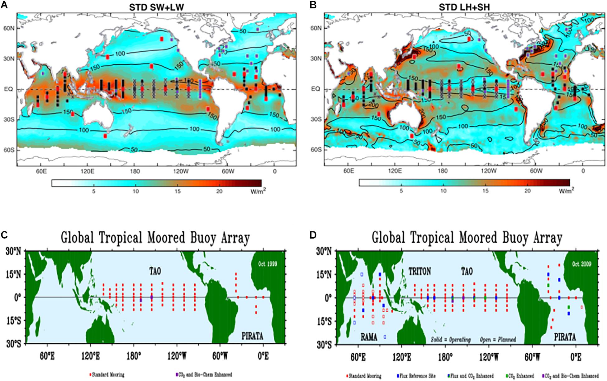
Figure 3. Standard deviation of the means based on 14 products for (A) SW + LW and (B) LH + SH for the 10-year period of 2001–2010. Black contours denote the ensemble mean patterns. The location of the global moored surface buoys is superimposed, with red dots indicating flux reference moorings (adapted from Yu, 2019). Detailed instrumentation of the Tropical moored buoy array in panel (C) 1990 and (D) 2009 (from McPhaden et al., 2010).
The meteorological and flux measurements from the RAMA moored buoy array are essential to improving these surface flux products. They serve as benchmark time series to help diagnose the problems in surface radiation and turbulent flux estimates and guide improvements in re-analyses models. Air–sea measurements using autonomous surface platforms, such as drifters, wavegliders, and saildrones, have advanced rapidly in recent years and are able to sample more regions and phenomena. Sustained observations capacities of such instruments need to be tested in the framework of process studies, an example is the persistent sampling of multiscale air–sea processes under extreme weather events. Future surface flux estimates, particularly in the deep convective regime associated with the Indo-Pacific warm pool, will benefit tremendously from the scientific and operational achievements made by the autonomous surface platforms.
IndOOS observations also provide critical data to evaluate and constrain ocean data assimilation (ODA) or ocean re-analyses products, which are crucial for estimations of decadal and long-term trends. In particular, RAMA and Argo are the backbone datasets for improving the fidelity and consistency of ODA products in the subsurface ocean (Dombrowsky et al., 2009; Lee et al., 2009; Fujii et al., 2015)2. IndOOS is also an integral element of GOOS, which contributes observations to the Ocean Reanalysis Intercomparison Project (ORA-IP) (Balmaseda et al., 2015) which carries out intercomparisons and evaluations of a suite of ODA systems.
However, significant deficiencies in, and discrepancies among, ODA products remain. These arise from limitations both in forward ocean models and in data assimilation. In order to test the fidelity of ODA products at decadal and longer time scales, and to test the success of ODA for initializing seasonal-to-interannual prediction, the observational records need to be far longer to cover many more realizations of interannual and decadal events. Although some of the requirements of the initial phase of IndOOS have been adjusted as our knowledge, technologies and logistical challenges have changed, sustaining and enhancing IndOOS is an imperative. For example, the role of the deep ocean below 2000 m (the maximum profiling depth of the current Argo array) will become more important at longer time scales and deep-ocean structure in ODA products remains poorly constrained. It is therefore necessary to develop deep Argo observations under IndOOS. Other areas where IndOOS needs to be enhanced include coastal regions that are not sampled by Argo and RAMA, and the ITF which has profound effects on marine biogeochemistry and ocean-atmosphere coupling in the eastern and tropical Indian Ocean. A comprehensive strategy is needed to ensure the monitoring of the ITF.
The continuity and enhancement of satellite measurements can help alleviate the sparsity of in situ measurements in coastal oceans and elsewhere. The Indian Ocean has some of the most dynamic salinity signals, due in part to the influence of monsoon, river runoff, and the ITF (Godhe et al., 2015), therefore, the continuity and improvement of satellite salinity measurements is necessary. Wind stress measurements are critical to studies of Indian Ocean dynamics and ocean-atmosphere coupling. Of particular importance is the need to enhance the temporal sampling of satellite-derived wind and wind stress measurements – in the equatorial Indian Ocean and the region near the Maritime Continent strong diurnal variability in the winds is important to MJO and MISO development. Currently, there are only two continuity series of satellite scatterometers: the MetOp series by the European Space Agency (ESA) and EUMETSAT, and the Oceansat series by the Indian Space Research Organization (ISRO). These two scatterometers provide approximately 60% coverage of the ocean at the 6-h interval, the de-correlation time scale of the diurnal cycle. Wind measurements from additional scatterometers and passive microwave radiometers are needed to reduce the aliasing of diurnal variations into lower frequencies.
Observations for the Ocean Modeling Community
Simulations and numerical experiments with various levels of model complexity are useful tools for studying ocean circulation and its variability. Open source models, such as the Modular Ocean Model (Griffies, 2012), Hybrid Coordinate Ocean Model (Bleck, 2002), MIT General Circulation Model (Marshall et al., 1997), and Regional Ocean Modeling System (Shchepetkin and McWilliams, 2005), enable many scientists, even those with limited access to scientific resources, to run experimental, regional simulations. In addition, global high-resolution prognostic and data-assimilated simulations provide large amounts of four-dimensional data, some of which are shared among the science community for detailed analyses of the ocean from a variety of viewpoints (e.g., Masumoto, 2010; Forget et al., 2015). The IndOOS plays a key role in these ocean modeling activities by providing initial and boundary conditions as well as data for validation of output, hence the need for them to be continuously obtained with reasonable time and space resolution for a long period with good quality and accuracy, with requirements for resolution and data quality dependent on target phenomena.
IndOOS is a major data source for basin-scale variability in the Indian Ocean. Essential observations include large-scale density distributions and associated circulations derived from temperature and salinity profiles obtained by hydrographic observations and Argo floats among others, surface heat and momentum fluxes between atmosphere and ocean measured mainly by RAMA, and sea level data from tide gauges. Variables at the sea surface can be measured by satellite remote sensing, which provides high temporal and spatial resolution data, particularly for SST, sea surface salinity, surface height, and fundamental variables related to the surface heat and momentum fluxes.
Attempts to incorporate biogeochemical and ecological processes in numerical ocean and earth system models are ongoing (Hood et al., 2003; Wiggert et al., 2006; Dilmahamod et al., 2015) and the extension of IndOOS to observe biogeochemical properties (Strutton et al., 2015) will be key to the evaluation and success of these models. The simulations so far are limited due to the sparseness of biogeochemical observations compared to the diverse and multi-scale processes involved in biological and ecological dynamics.
Various indices that represent observed phenomena and conditions have been used for testing the ability of models to simulate realistic variability. Some examples are the ITF transport, as an inflow condition for Indian Ocean basin models (e.g., Meyers et al., 1995), the Dipole Mode Index (DMI) for interannual climate variations in the tropical region (e.g., Saji et al., 1999), and eddy kinetic energy distribution for validation of mesoscale fields in models (e.g., Chelton et al., 2011). These indices are needed over long durations, with temporal resolutions of 1 month or less, to investigate variability at interannual-to-decadal scales as well as interannual modulation of shorter time-scale phenomena such as MJO.
Needs From Forecasting and Prediction Community
The ultimate goal of both the observing and modeling communities is to provide accurate marine and weather forecasts and climate predictions. For this, sustained surface and subsurface information from RAMA, Argo, and other observing platforms of IndOOS are essential. For improvements in the prediction of weather and climate over the Indian Ocean rim countries and islands, and globally, we need to pay particular regard to the IOD, MISO, and the MJO. In parallel to this is the need to have a better understanding of the sub-mesoscale processes, particularly within the coastal regions and it is important to highlight the need for regional and process studies, in particular within countries EEZs for improved high resolution models. Ongoing issues around this is the availability of data and the need for the global modeling community to continue to work with countries, identifying the importance of such models for improved products which will benefit the countries.
Indian Ocean Dipole
Several studies have reported that the IOD could be predicted one season ahead with reasonable accuracy using a dynamical prediction system based on a Coupled General Circulation Model (CGCM) (e.g., Wajsowicz, 2005; Luo et al., 2008; Zhao and Hendon, 2009; Zhu et al., 2015; Liu et al., 2017). Some strong IOD events were actually predicted a few seasons ahead (Luo et al., 2008). Based on these scientific outcomes, a real-time forecast of the IOD is now provided every month by several institutions around the world [e.g., Japan Agency for Marine-Earth Science and Technology (JAMSTEC), BoM, United Kingdom Meteorological Office, Asia-Pacific Economic Cooperation Climate Centre].
However, many of the state-of-the-art CGCMs, such as the National Center for Environmental Prediction Climate Forecast System version 2 (CFSv2), still lack the skill to be significantly better than persistence in predicting IOD events (Zhu et al., 2015). The skill of IOD predictions is affected by event-to-event diversity that may be rooted in differing development mechanisms (Tanizaki et al., 2017). Moreover, some IOD events appear to be triggered by weather noise and intra-seasonal disturbances and have low potential predictability, while other events that co-occur with ENSO are more predictable (Song et al., 2008; Yang et al., 2015).
In an attempt to understand the role of subsurface conditions on IOD predictability, Doi et al. (2017) conducted two reforecast experiments based on a fully coupled GCM. One used only SST for the initialization, the other used SST plus subsurface temperature and salinity aggregated from in situ observations, such as XBTs, moored buoys, and Argo floats. Although the ENSO prediction skill did not change significantly between the two experiments, the IOD prediction skill was significantly improved. Feng et al. (2016) also showed that subsurface ocean observations can reduce large uncertainty in the IOD prediction, and may allow long-lead time prediction from boreal winter. Multi-decadal variability in the background state of the Indian Ocean also likely plays a role for IOD frequency, strength of the co-variability with ENSO, and predictability (c.f., Annamalai et al., 2005; Ummenhofer et al., 2017), as shown explicitly also for ENSO predictability (e.g., Jeong et al., 2015; Zhao et al., 2016). Continuation and expansion of surface and subsurface ocean observing platforms are necessary for continuing progress on prediction research and quasi-real time forecast services.
Madden–Julian Oscillation
The unique character of intraseasonal variability, and especially the MJO, in the Indian Ocean has become apparent through studies based largely on satellite SST microwave imagery and in situ observations during programs such as the Cooperative Indian Ocean Experiment on Intraseasonal Variability (CINDY)-Dynamics of the MJO (DYNAMO) in the central equatorial Indian Ocean (DeMott et al., 2015). The MJO is also a centerpiece in the emerging effort to develop skilled forecasts at subseasonal to seasonal (S2S) time scales (Vitart and Robertson, 2018). The MJO induces strong variability in SST along the western Indian Ocean thermocline ridge (Harrison and Vecchi, 2001; Saji et al., 2006; Vialard et al., 2008) and this variability feeds back onto the MJO (DeMott et al., 2015). With improved availability of SST from satellite, the signature of the MJO to the north west of Australia is now recognized to be larger than in the central Indian Ocean (Duvel and Vialard, 2007; Vialard et al., 2013). The amplitude of the diurnal cycle of SST is also strongly modulated by the MJO in this region (Bellenger and Duvel, 2009) and affects the mean SST and the intraseasonal SST variability (e.g., Shinoda and Hendon, 1998; Shinoda, 2005; Bernie et al., 2005). The modulation of the diurnal cycle of SST in the equatorial Indian Ocean can also help promote the onset of the convective phase of the MJO, through rectified effects on latent heat flux (Seo et al., 2014).
Observing and understanding the intraseasonal variation of the upper Indian Ocean driven by the MJO challenge the observing system because it requires high vertical resolution in the upper ocean, measurement of the diurnal cycle, and accurate measurement of surface fluxes. Duvel and Vialard (2007) propose that the maximum amplitude of intraseasonal SST variation occurs to the northwest of Australia because of peak MJO-driven variability of intraseasonal surface heat flux coincident with a shallow mixed layer. However, there are no direct measurements of the surface fluxes or the diurnal cycle of SST in this region of the Indian Ocean. This dearth of observations is reflected in differences as large as the mean between surface heat flux estimates from different re-analyses.
In addition to the IOD and MJO, the monsoon and its intraseasonal and interannual variability also plays a dominant role for the climate of Indian Ocean rim countries. Similar to MJO, the MISO is also an ocean-atmospheric coupled intraseasonal variability, originating in the equatorial Indian Ocean and influencing the active and break phases of the Asian monsoon. Both short-term (MISO) and seasonal monsoon predictions depend on the ocean initial conditions. Hence, the IndOOS observation program may potentially contribute to the improvement of monsoon prediction.
End User Engagement: Data Accessibility and Transparency
As discussed in Section “Societal Needs for Observing Systems”, there are a range of societal needs for Indian Ocean observation capability, which arise given the complex interactions between observed phenomena and environmental benefits and risks including those associated with marine ecosystems (e.g., concerning fisheries, tourism), extreme events (e.g., casualties, damages to infrastructures), monsoon rains (e.g., agricultural productivity) and climate regulation generally. The utility of IndOOS to decision-making around these benefits and risks depends on the identification of, and engagement with, end-users of the System, and on the practical accessibility and transparency of data in a wide range of decision-making processes operating on multiple scales. Current progress, issues and challenges related to end user identification and engagement for IndOOS are surveyed below.
IndOOS has been developed in the context of rapid intensification of anthropogenic interactions with the Indian Ocean, driven by coastal population growth, coastal and ocean-based economic development, and other factors (Obura, 2017). Analysis published in 2016 by the Organization for Economic Co-operation and Development (OECD) forecasts sustained global growth in ocean-based economic activity, coupled with structural change resulting from growth in “emerging sectors” such as aquaculture, offshore energy infrastructure, marine biotechnology, and maritime safety and surveillance (OECD, 2016). Many economic sectors in the Indian Ocean region are fundamentally underpinned by marine environmental goods and services (Obura, 2017). Analysis of the status of these depends on access to a wide range of social, economic and environmental data, including the outputs of IndOOS that focus as explained above on biogeochemical, oceanographic and atmospheric data.
A major challenge for economic decision-makers across the Indian Ocean region is the severe fragmentation of data – supplied by IndOOS and many other sources – relevant to integrated analysis of environmental dependencies and risks associated with economic activity. Macro-economic data in most Indian Ocean countries is largely standardized and collected regularly through national accounting processes, organized in terms of the UN System of National Accounts (United Nations et al., 2008). Since 2012 a growing number of countries have undertaken efforts to develop integrated accounting frameworks for environmental statistics that are compatible with the structure of SNA accounts, supported by the UN System for Environmental Economic Accounting (SEEA; United Nations, 2018a), Framework for Development of Environment Statistics (FDES; United Nations, 2018b), and related approaches. The application of these approaches to ocean observation data has been very limited to date. In 2018 the UN established an Ocean Accounts Partnership that is specifically designed to address this deficiency, through pilot application of FDES, SEEA, and the SNA to ocean-related data and statistics (ESCAP, 2018). This inter-governmental effort has important implications for IndOOS and ocean observation generally, because it offers opportunities for “value-addition” to fundamental ocean-observation data through integrated presentation and analysis alongside relevant social, economic and other environmental data.
Beyond the realm of economic decision-making, an important group of end-users for IndOOS data are those involved in the planning, monitoring and reporting of wider efforts to achieve sustainable development in the Indian Ocean region, in line with national priorities and international commitments such as the 17 sustainable development goals (SDGs) and 169 associated Targets (UNGA, 2015). These efforts are characterized by the central role of national and international indicators of sustainable development, which relate to a very broad range of subject matter including poverty alleviation, ecosystem condition and services, food security, risk and resilience, consumption and production, climate change, and other factors where IndOOS data may (or may not) be of relevance (U. N. Statistics Division, 2018). In this context a pressing technical challenge is the need to clearly identify the ocean observation data dependencies of these indicators, and practical methods for indicator compilation based on IndOOS and other data, which accommodate the acute capacity challenges in many Indian Ocean countries (see section “Key Regional and Process Efforts Connecting With IndOOS”). Considerable progress to these ends has already been achieved through efforts to define “Essential Ocean Variables” for sustained observation of biodiversity and ecosystem changes in light of societal needs as defined in the SDGs (Miloslavich et al., 2018).
The end-user community for IndOOS also includes scientific and technical experts in other disciplines, including ocean-focused ecologists, economists, geographers, policy analysts, and many others. For this group of end-users, engagement challenges include the need to connect specialized use-cases for ocean observation data (i.e., ocean state estimation, atmospheric re-analyses, and surface flux estimation) with other fields of analysis (e.g., ecological assessment, input-output analysis, cost-benefit analysis). This also serves to highlight the need for the links with regional and process orientated observing programs. Opportunities also exist to leverage the capability of global data analysis and communication initiatives for the benefit of ocean observation specifically tailored to meeting societal needs in the Indian Ocean region. For example institutional and data connections with the Blue Planet Initiative of the Group on Earth Observations (BP-GEO) could leverage BP-GEO’s aims to address global challenges and improve decision-making through coordination and development of Earth observation efforts among 105 Member governments, supported by several non-governmental organizations (GEO, 2017).
There is a strong need to ensure that Indian Ocean rim countries have access to the data produced through IndOOS, as well as understanding its applications. As highlighted in Section “Capacity Development”, a number of workshops have taken place in order to implement this, but these efforts need to be sustained. A possible mechanism for continuing this and for ensuring that IndOOS reaches Government stakeholders and policy makers is to use the Indian Ocean Rim Association3 and its sub grouping of the Academic Group. IORA is an intergovernmental group (22 member states and 9 dialogue partners) set up to support socio-economic activities between these countries. A large subset of the Indian Ocean rim countries are also members of the Commonwealth (of Nations), which is providing a forum for the integration of ocean observations in delivering against SDG targets and United Nations Framework Convention on Climate Change (UNFCCC) requirements through its Commonwealth Blue Charter action group on the topic.
Future Vision
IndOOS Enhancement
The main focus of IndOOS is to maintain a sustained basin-scale observing system, which is flexible in terms of emerging technologies and issues (such as marine heat waves in response to a changing climate and plastic pollution) and provides a framework for enhanced regional and coastal monitoring. Looking forward, the IndOOS needs to be sustained, modified, and enhanced to meet societal need for improved understanding and predictability of Indian Ocean climate (Figure 2b).
The recommendations of the IndOOS decadal review, which will be finalized in 2019, are given in tiers. Tier I relates to sustainment of the essential components of IndOOS, while streamlining the observing system in consideration of redundancy and logistical constraints: Core in situ programs with upgraded technology, satellite observations, and ITF monitoring; Tier II lists priority enhancements to extend IndOOS capacities to better address scientific and operational drivers: Including increasing biogeochemical measurements, boundary flux arrays and increased engagement with Indian Ocean rim countries and Tier III lists desirable components: Pilot projects that promote advancements, some of which may be integrated into the IndOOS and contribute to its sustainability, as well as enhancements with new autonomous and expendable platforms and new sensor technologies.
Expanding the Current Observations
With the reduction in piracy, the expansion of the RAMA array westward must be completed to capture air–sea interaction important to intraseasonal and monsoon dynamics, as well as cross-equatorial heat transport and processes underpinning the strong oceanic productivity and variability of the marked OMZ in this region. The RAMA array also requires enhancement in the vertical resolution of temperature and salinity measurements, and direct flux measurements at key sites in order for improved subseasonal-to-seasonal forecasting and surface flux products. Argo floats need to be doubled close to the equator (10°S to 10°N) to improve the resolution of intraseasonal to interannual variability which is critical for observing and predicting IOD, monsoons, and MJO. Increasing the number of Argo floats with biogeochemical sensors, particularly in regions of upwelling and OMZ such as the Arabian Sea and Bay of Bengal, is a priority in order to capture the links between physical climate and ecosystem changes. The BGC-Argo implementation plan is for 1000 floats globally, based on several OSSE, translating to 200 biogeochemical floats in the Indian Ocean, which represents 20% of the global ocean. Core biogeochemical sensor specification includes dissolved oxygen, nitrate, pH, chlorophyll fluorescence, optical backscattering and downwelling irradiance (Johnson and Claustre, 2016). Presently there are 105 floats with biogeochemical sensors, although none yet conform to this full design specification. Given that it is prohibitively expensive to deploy enough sensors at the most useful depths on moorings alone and that there are no moorings in some of the most biogeochemically important regions, such as the Western Arabian Sea and the Madagascar bloom, BGC sensors on Argo floats will be a vital part of the future of IndOOS. Although the number of presently active Argo floats overall is a positive sign, the funding levels of many nations are either flat or declining, posing a serious challenge to enhancing and sustaining the array (Durack et al., 2016). This is compounded considering that biogeochemical Argos are three-to-four times as expensive compared to Argos, in terms of equipment, maintenance and human resources (Johnson and Claustre, 2016).
In addition, Deep Argo needs to be piloted and expanded, given that the deep ocean below 2000 m, especially in the Southern Hemisphere mid-to-high latitudes, contributes a significant fraction of the total water column increase in heat content and thermosteric sea-level rise (Fukasawa et al., 2004; Johnson et al., 2008; Purkey and Johnson, 2010, 2013). Based on the global design goal of one deep Argo float per 5° × 5°, the Indian Ocean requires at least 250 floats north of 40°S, while currently there are 14 (Figure 2c).
Surface drifters need to be augmented with barometric sensors to support weather and seasonal forecasting. Essential XBT lines such as those monitoring the ITF output or crossing the Arabian Sea upwellings need to be maintained or enhanced, as do western and eastern boundary arrays in the southern subtropical gyre, to quantify mass and heat fluxes and improve predictability of basin-scale heat content change. The Global Sea Level Observing System (GLOSS) network needs to be expanded and data made available. Utilization of new autonomous and/or expendable platforms and new sensor technologies should always be explored for enhancements of IndOOS.
It is not just in situ observations that need to be enhanced; satellite missions provide key variables to complement IndOOS and need to be supported to ensure good continuity for EOVS, in particular measurements of surface winds at diurnal timescale, all-weather sea surface temperature, sea surface height, sea surface salinity and ocean color are of highest priority (Essential Tier I). In situ data provides calibration, validation and extrapolation (e.g., from surface to vertical) of satellite measurements and help de-alias signals that are not adequately sampled.
The focus of the aforementioned observations are beyond the EEZ, however, future observing systems need to consider the coastal zone, as a key region for understanding and monitoring the ocean’s influence on, and response to, climate change processes. Coastal dynamics play a substantial role on the open ocean by modulating air–sea fluxes and distributing nutrients and marine plankton, and influencing the monsoon variability and MJO (e.g., Prasanna Kumar et al., 2001; Vialard et al., 2012). While the coastal zone is not directly covered by IndOOS currently, except for the expansion related to boundary current arrays, future enhancement of IndOOS needs to include these waters (Tier III; pilot projects, exploring IndOOS integration) for the study of coastal currents, coastal heatwaves OMZ, ocean acidification, carbon uptake, land sea interaction through, for example, effluent discharge from terrestrial sources and other critical processes, which infringe on or occur within EEZs and which are especially poorly monitored in the Indian Ocean. Future work also needs to consider the complex relationships between society and the sea, in particular around the impacts of human exploitation on marine resources and the impacts this has. The coastal regions of the Indian Ocean rim countries are the most densely populated of any region and vulnerable to changing sea levels, warming ocean temperatures, deteriorating marine ecosystems and extreme weather events (Nicholls and Cazenave, 2010). Societal needs and scientific benefits are greatest within the coastal ocean, and hence it is essential to monitor these regions. Autonomous devices such as gliders have great potential to measure the coastal ocean. It is imperative that coastal states allow open access to monitor physical and biogeochemical parameters in these regions. A first step in this direction has been achieved through the Argo float program and there is an ongoing process being led by the World Meteorological Organization (WMO) and Intergovernmental Oceanographic Commission (IOC) to come to an agreement around observations in EEZs,4 but it remains a complex, legal task. Where possible the IndOOS community needs to support national efforts of Indian Ocean rim countries, including through capacity building, in setting up long-term observing programs and ensuring that measurements are relevant and quality-controlled and that the data is archived and shared.
Key Regional and Process Efforts Connecting With IndOOS
Although IndOOS does not have a specific focus on regional and process-orientated observing programs there are important synergies. IndOOS provides a framework to facilitate, support, and enhance them, while regional programs may also support IndOOS, for example, through ship time and deployment of assets. To this effect, six key examples or regional and process efforts, which should be sustained, in conjunction with IndOOS are:
(a) Changes in OMZs and impact on ecosystem, fish distribution and decline.
In a region where many people are dependent on fisheries for their livelihoods (Barange et al., 2014) the motivation for improved understanding and forecasting of OMZs is evident, particularly in the intense marine productivity region of the North Indian Ocean. As a whole, Indian Ocean biophysical processes and the carbon cycle remain poorly understood. To address this, the RAMA array will be extended into the western Indian Ocean/Arabian Sea and Bay of Bengal with biogeochemical sensors, Biogeochemical (BGC)-Argo deployments will be prioritized in a number of key areas, and a portion of the IX01 XBT line will be re-activated.
(b) Integrated physical, chemical, and biological observations south of Java and Sumatra upwelling systems.
Recognizing the importance of the upwelling systems in the Eastern Indian Ocean, integrated physical, chemical, and biological observations south of Java and Sumatra are being rolled out as part of the Second International Indian Ocean Expedition (IIOE2, Hood et al., 2015). Biogeochemical cycles, such as carbon and nitrogen cycles, and ecosystems in this region respond to the background physical conditions, as observed by RAMA and other IndOOS assets, showing significant responses to variability at various time-scales spanning hours to long-term trends. The ecosystem is also influenced directly by human activities such as nutrients in river discharge, increasing aeolian dust flux, ocean acidification, overfishing, and increasing pollutants (e.g., Jickells et al., 2017). Understanding possible mechanisms of physical, biogeochemical, and ecosystem responses to natural and anthropogenic perturbations is an emergent issue of marine science, with increasing human activity degrading the quality and quantity of marine ecosystem services on which our society is dependent. The main part of this activity consists of in situ observations using research vessels. Data from IndOOS will be utilized as background information to this research activity and, in turn, RAMA sites will be maintained and new technologies tested for IndOOS.
(c) Surface fluxes and diurnal mixed layer variability at key tropical sites and improvement of monsoon, MJO, and MISO prediction.
Increasing societal demand for seasonal to decadal climate predictability in the face of global warming makes the need for strategic, sustained observations in the Indian Ocean more urgent. In particular, a Tier II recommendation of the IndOOS decadal review states the need for air–sea flux reference sites in key tropical areas to collect measurements of high temporal resolution, including upper ocean properties, to complement satellite observations. A regional program supporting this effort is the Timor Sea Flux Station (TSFS), aimed at observing diurnal to seasonal variability in surface fluxes, mixed layer ocean structure, and surface meteorology. The location of the TSFS has been chosen to target the MJO and its interaction with the ocean and the formation of diurnal warm layers (Figure 2b, purple square). Better understanding of the MJO is a high priority for the Australian Bureau of Meteorology (BoM) as it impacts on rainfall forecasts across much of Australia. SST (and heat content) at the location of the proposed mooring exhibits strong correlations with seasonal rainfall over mainland Australia, which may be independent of large-scale ocean dynamics, such as IOD, at times.
(d) Monsoons and associated air–sea interactions.
The monsoons impact large populations and understanding and prediction of monsoon dynamics needs improvement over the next decade. Since March 2010, the South China Sea Institute of Oceanology (SCSIO), Chinese Academy of Sciences has established a hydrological and marine meteorological observation network over the tropical eastern Indian Ocean to enhance the understanding of monsoonal air–sea interaction. This includes 9 years of Indian Ocean cruises collecting continuous oceanic and meteorological observations, including conductivity, temperature, and depth (CTD) measurements, Global Positioning System radiosonde, and automatic weather station data (Figure 4). Observations prior to the monsoon are very important because the air–sea interaction within these periods can be a precursor for monsoon onset. Data from these in situ observations will have an important value for assimilation into ocean re-analyses and for weather and seasonal forecast models.
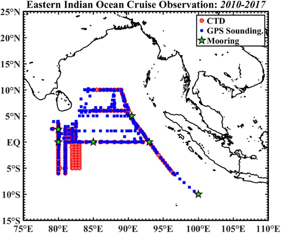
Figure 4. Observation stations of the Eastern Indian Ocean cruises led by the South China Sea Institute of Oceanology, Chinese Academy of Sciences during 2010–2017.
(e) The Agulhas Current System and associated air–sea interaction and upwelling.
Measuring the Agulhas Current has been identified as a Tier II future priority in the IndOOS decadal review, largely owing to its dominant role in basin-wide heat and freshwater budgets. For western Indian Ocean countries, particularly South Africa, measurements of the greater Agulhas system and its leakage are also a priority, given its influence on regional climate and ecosystems, yet there is no integrated observing system for the region. Since 2010, the US led Agulhas Current Timeseries (Beal et al., 2015) was followed by the South African and US led Agulhas System Climate Array (ASCA; Morris et al., 2017), however, ships’ availability and lack of resources resulted in the early termination of ASCA in 2018.
Observations and satellite remote sensing have highlighted significant limitations of ocean models of the region. These model errors directly affect the ability to routinely predict the marine and maritime environment, adversely affecting management and policy decisions and stunting the growth of the ocean economy in southern Africa. Furthermore meso- and submesoscale processes, which directly influence rainfall, are central drivers of oceanic connectivity and productivity around southern Africa, where food security is of utmost importance. The inability of coarse resolution climate models to accurately resolve these processes lead to uncertainties of future climate projections. The South African community is working to design and implement a cost-effective and regionally appropriate integrated ocean observing system, tailored to provide routine monitoring of key parameters, strengthen the understanding of crucial processes, and help accelerate model development. Key elements are an Agulhas array enhanced with glider measurements over the shelf and slope and a full depth mooring array into the southeast Atlantic and other dedicated, multi-disciplinary programs (Morris et al., 2017; Paterson et al., 2018). This will better enable end users to manage marine ecosystem health, pollution, hazards and maritime safety and help to build a society resilient to climate variability and change.
(f) Cross-equatorial overturning cell.
In the eastern equatorial Indian Ocean six deep moorings, extending down to 1000 m with upward- and downward-looking Accoustic Doppler Current Profilers (ADCPs) have been occupied by SCSIO since 2015. This array follows the deep ocean current meter moorings maintained by India last decade and will measure variations associated with the cross-equatorial overturning cell in the Indian Ocean. The dynamic processes of the equatorial deep Indian Ocean influence the mass and heat budgets of deep ocean variability (Chen et al., 2016; Huang et al., 2018a,b,c).
Measuring the variability of these regional components contemporaneously is a future vision of IndOOS and will improve the understanding and predictability of Indian Ocean climate. For example, the heat and freshwater budgets of the Indian Ocean are dominated by three components of similar magnitude (Figure 2c): an inflow of fresh tropical waters via the ITF (Sprintall et al., 2009; Roberts et al., 2017; Zhang et al., 2018); an upper-ocean overturning cell linking upwelling in the Northern Hemisphere and in the Seychelles-Chagos thermocline ridge with subduction of mode waters at the southern reaches of the basin (Schott et al., 2009; Han et al., 2014); and a horizontal gyre circulation dominated by the warm and salty waters of the Agulhas Current (Bryden and Beal, 2001). The ITF is thought to be shoaling and strengthening as a result of strengthening Pacific Trade winds and increasing rainfall over the Indonesian Seas (Wijffels et al., 2008; Feng et al., 2011; Sprintall and Révelard, 2014; Hu and Sprintall, 2017) and has been put forward as the main proponent of rapid Indian Ocean heat gain (Lee et al., 2015; Zhang et al., 2018). However, warming is a maximum at the southern reaches of the basin, far from the ITF, and within the Agulhas system (Alory et al., 2007; Wu et al., 2012), where variability in the other components of the heat budget are more poorly constrained. There are decadal changes in Indian Ocean thermocline waters, which reversed from freshening (Bindoff and McDougall, 2000) to becoming saltier (McDonagh et al., 2005), while the subtropical gyre may be spinning up and expanding in response to strengthening Westerlies (Palmer et al., 2004; McDonagh et al., 2005; Alory et al., 2007). Yet an increase in southward heat transport appears related to warming, but not strengthening, in both the Agulhas and Leeuwin Currents (Beal and Elipot, 2016; Hernández-Guerra and Talley, 2016; Zhang et al., 2018).
The Importance of Linking IndOOS to Regional Efforts
It is essential that the international community support the regional efforts, as they are generally considered more relevant by the various Indian Ocean rim governments due to the direct impact on the coastlines. The regional programs are also very valuable for the re-analyses community. As prioritized through IndOOS, dense, daily-to-monthly observations of velocity, temperature, and salinity across the ITF, Agulhas, and Leeuwin Currents, are needed, combined with hydrographic end-point moorings, similar to those used to measure the Atlantic overturning (Johns et al., 2011), across the open southern boundary of the basin. Continuation of existent Argo, satellite (sea surface height, wind), and GO-SHIP programs are also essential. However, monitoring boundary currents and exchanges like the ITF and Agulhas Current is a particularly challenging frontier due to their dynamic environments and small time and length-scales. Innovative strategies for integrated observing systems are required, for example combining current meter arrays, gliders, and Current and Pressure Inverted Echosounders with periodic hydrographic sections for important climate variables such as carbon, nutrients, and oxygen. In addition, innovation in real-time data return for subsurface arrays, such as fast telemetry and data pods, is necessary.
Future strategies for IndOOS, particularly regarding connection to end users and stakeholders, need to be better linked to regional and national efforts, such as via the GOOS Regional Alliances. A key factor affecting investment in scientific research is the level of national appreciation of the importance of the marine sector to the country’s economy and resources. GOOS (and associated Regional Alliances) is in a unique position to be able to make the case to national governments and stakeholders (GOOS strategy) through the IOC of the United Nations Educational, Scientific and Cultural Organization (UNESCO). To support regional capacity development and involvement in the sustained observations, international partnerships need to be fostered and maintained, in particular with Indian Ocean rim countries. Intergovernmental bodies such as WMO and IOC, as well as international scientific bodies such as CLIVAR and Scientific Commission for Oceanographic Research (SCOR) can be used to help facilitate this. It is essential to improve evaluation mechanisms for what has been achieved to date and consider long term thinking around funding mechanisms. These programs also serve a vital role with regards to performing observations and accessing data held within countries EEZs.
Implementation Challenges for IndOOS
Sustained observing systems over the Indian Ocean face general challenges as is common to all basin-wide observing systems. However, the Indian Ocean has its own unique challenges due to the physics of the basin, as described, as well as the problems within the Indian Ocean countries that rely heavily on coastal regions for food security. Special focus needs to be placed on access to EEZs for observing system components (such as boundary arrays), and on capacity, resource and coordination development of rim countries that remains a challenge due to human resources, finances, and logistics. International coordination, best practices, and data sharing are also challenges. With strong potential synergies between IndOOS, process studies, and regional observing systems (see section “Key Regional and Process Efforts Connecting With IndOOS”) integration and mutual interactions have not developed satisfactorily over the last decade. There is a need to develop an effective strategy for merging regional and process oriented observing systems with the basin-scale IndOOS.
Access to the EEZ
The coastal zone is especially poorly monitored in the Indian Ocean, yet societal needs and scientific benefits are most immediate within the coastal ocean and hence it is essential to systematically observe these regions. Some regional observing systems have been developed and work well within the GOOS Regional Alliance system, for example the Integrated Marine Observing System (IMOS) of Australia. In general, marine observations for research purposes are permitted with appropriate applications to countries, whose EEZs and/or territorial waters include observation fields. However, some countries are apprehensive about deploying, permitting, or making freely available ocean measurements in their EEZs for concerns over national security, resource development, or other reasons. Research cruises undertaken on foreign ships are often not allowed to measure in EEZs and must cease sampling when they transit through an EEZ. Some countries restrict access to coastal tide gauge station data, either in real time or delayed mode. In June 2018 the Secretary of the Indian Ministry of Earth Sciences (MoES) announced that its OMNI data would be made freely available outside the Indian EEZ, while data availability is still restricted for OMNI moorings inside the EEZ. When Argo and bio-Argo floats deployed in the open ocean drift into an EEZ, the deploying nation must inform the respective coastal state (IOC Resolution EC-XLI.4) via the Joint WMO-IOC Technical Commission for Oceanography and Marine Meteorology (JCOMM) in situ Observing Programs Support Centre (JCOMMOPS) (though no country has asked that Argo data be turned off within an EEZ).
The problem of measuring in EEZs is a longstanding one that complicates both the implementation of IndOOS and utilization of its data. However, this reality does not diminish the imperative to systematically observe in EEZs, as these regions are crucial from both a scientific and a societal perspective. The IndOOS community can be an effective agent for change by highlighting these needs and the benefits that a more open access policy can deliver.
Capacity Development
Capacity development is essential for training the next generation of researchers and technicians and for ensuring that Indian Ocean rim countries take ownership and contribute toward the sustainability of observing systems, as well as the use and dissemination of their data. The transfer of knowledge and information through capacity development is not only an essential pursuit in its own right, for the direct applied benefits that it brings to society, but also important in raising awareness of the benefits of ocean observations to decision and policy makers and their constituents, thereby enhancing the case to support and resource the essential components of IndOOS.
From the initial planning in the late 1990s and the subsequent implementation of the IndOOS, through to the more recent efforts of the related, multi-national program of IIOE-2, capacity development has been woven in as a critical element to demonstrate the utility of Indian Ocean data. To date approximately twenty capacity development workshops have been held across the Indian Ocean basin under the auspices of IndOOS to ensure broad understanding in the rim nations of the social and economic applications and benefits of IndOOS, as well as technological training in sustainment of these vital meteorological and oceanic observations. Some examples of established capacity development programs include the Partnerships for New GEOSS (Global Earth Observing System of Systems) Applications (PANGEA5). PANGEA provides in-country practical training in applications of ocean data to large and diverse groups of regional participants, fostering partnerships between developed and developing countries to realize the social-economic benefits of ocean observing systems. As part of their contribution to the PANGEA concept a series of six Western Indian Ocean capacity development workshops have been convened by JCOMM’s Data Buoy Cooperation Panel (DBCP) Task Team for Capacity Building (TT-CB), with the overarching goal to empower developing States by providing expert training on the applications of ocean observation data for understanding and predicting regional weather, ocean, and climate and their impact on fisheries, coastal zone management, natural disasters, water resource management, human health and others.
In addition to individual capacity development workshops, several JCOMM PANGEA “Resource-Sharing” long-term Partnerships have been fostered to implement and sustain the IndOOS and deliver training in practical application. These include formal partnerships between the U.S. National Oceanic and Atmospheric Administration (NOAA) and India’s MoES and between NOAA and the Indonesian Agency for Meteorology, Climatology and Geophysics (BMKG). NOAA’s in-country annual capacity development workshops in Indonesia have demonstrated practical applications of ocean observations through training by scientists from NOAA’s Pacific Marine Environmental Laboratory (PMEL), Climate Prediction Center (CPC), and Ocean Prediction Center (OPC). BMKG has recently made the decision to invest USD $150M in the Indonesian Seas for maritime observations to advance societal-economic applications in S2S climate forecasting, shipping, fisheries, and other applications. Indonesia’s major investment will contribute to observing capacity in the eastern Indian Ocean.
In parallel with these efforts, a major capacity development initiative strongly aligned with IndOOS is that coordinated through the IIOE-2. For example, all IIOE-2 endorsed projects are required to include capacity development elements into their frameworks, such as berths on research vessels and opportunities for fundamental science projects for young and emerging scientists and practitioners. The IIOE-2 also has capacity development built into its overall framework through the IIOE-2 Early Career Scientists Network, which at present has more than 500 members. The IOC institutional capacity development programs also connect with IndOOS and its science community through specific training programs, and through data and information management initiatives coordinated out if the IOC’s Oostende regional office and associated with the International Ocean Data Exchange (IODE) program (including the OceanTeacher Global Academy).
Thus far, basin scale observations receive only small amounts of funding from developing countries. However, support for programs within EEZs is essential and hence such programs should ideally involve rim countries from inception. The GOOS Regional Alliances (e.g., Indian Ocean GOOS (IOGOOS), IMOS, The Southeast Asian GOOS, GOOS-AFRICA) provide connections among government institutions for support of such regional programs and the IOC framework can provide an understanding of the needs of a country. IOC Regional Subsidiary Bodies and Regional Committees play a similar role through their own capacity development programs [e.g., IOC Sub-Commission for Africa and the Adjacent Island States (IOC AFRICA), IOC Sub-Commission for the Western Pacific (WESTPAC), IOC Regional Committee for the Central Indian Ocean (IOCINDIO)]. Similarly, national efforts through regional training centers (e.g., the Regional Training and Research Center in China and Indonesia) and IOC Category II Centers for training and education (e.g., in the Islamic Republic of Iran and India) provide expertise and logistical resources for capacity development programs, which can and do take advantage of valuable IndOOS data. Many countries in the Indian Ocean rim do not have extensive marine organizations, or they are relatively small sections within government departments such as fisheries or meteorological services, and these sections need to be enhanced and developed. With evolving new autonomous technologies the scope to increase capacity development both in the technical and science realms is growing. It is important to share experiences and efforts in a coordinated manner and to continue to ensure societal relevance of the science and predictive capacities that comes from IndOOS.
International Coordination
IndOOS comprises satellite and in situ measurement systems operated by a wide variety of institutions in many different countries. As such, it is a major effort to coordinate implementation and maintenance of the network and maximize its societal benefit. To give one example of the scope and complexity of the undertaking, RAMA partners have conducted 85 cruises on 21 different ships from 11 different nations, using 2053 days of ship time to deploy and recover 325 moorings in the 14 years since September 2004.
The in situ components of IndOOS were designed, implemented and, since 2004, scientifically guided by a group of scientists within the IORP established under the World Climate Research Programme (WCRP)-CLIVAR and IOC-GOOS and aligned with IOGOOS. The IORP seeks to include and encourage all the rim countries to participate in the scientific leadership of IndOOS, and to contribute through not only observing platforms themselves but also technical transfer, capacity development, and data management and dissemination. Resources for the sustainment of the IndOOS, and for the recommended enhancements of the IndOOS moving forward, are a significant issue, particularly the human resources, shiptime, and equipment necessary for keeping the system healthy and quality-controlled data freely accessible. The IRF helps to find and coordinate national contributions to the observing system, while minimizing duplication of effort and maximizing scientific return on investment.
Beyond the IORP and IRF, each observing system element has its own global coordinating body. For satellites, there is the Committee on Earth Observation Satellites (CEOS); for moorings, the Global Tropical Moored Buoy Array (GTMBA) office at NOAA/PMEL and the Tropical Moored Buoy Implementation Panel (TIP); for drifting buoys, the GDP; for tide gauge stations, the GLOSS; for XBT and related observations, Ship of Opportunity Program; and for repeat hydrographic measurements, the GO-SHIP program. For Argo, the Argo Science Team provides overall scientific guidance. Indian Ocean Argo deployments are coordinated by Argo Regional Data Center6 along with the Argo Information Center (AIC), including information on ships of opportunity and research vessels and guidance on regional float deployments.
JCOMM strives to integrate across these observing system programs to provide data management and services for the GOOS. The JCOMM Observations Program Support (OPS) Centre provides support services for the coordinated implementation of the observing system. Also within JCOMM is the DBCP, which focuses its efforts on coordinating the application of autonomous data buoy data. Within the DBCP are several Action Groups, one of which is the TIP whose goal is to coordinate across tropical moored buoy programs, such as RAMA. These nested and overlapping scientific, implementation, and resource bodies ensure a high degree of coordination such that accumulated knowledge concerning measurement technologies and strategies is shared for the benefit of both data providers and users. However, there is limited representation at these international level committees of Indian Ocean rim countries and small island developing states.
Best Practices
One of the challenges for IndOOS is ensuring the quality and accuracy of data. Sustained measurements need careful calibration and inter-calibration if they are to provide records of climate variability and change. As described in the previous section, IndOOS has been implemented via a variety of national and international programs and projects, across which observing practices and data quality can be heterogeneous. At the regional level there are sometimes less capabilities for ocean observing. JCOMM programs such as GLOSS function well, with technical transfer and support offered and Indian Ocean rim countries taking ownership of high quality data due to the importance and direct impact sea level rise has on their coastal communities. The deeper ocean measurements (e.g., through Argo and GO-SHIP) are dominated by Australia and India in terms of rim countries and farther afield by the US, Europe and China. This is due to access to ship time and funding for equipment as well, in part, to the limited understanding of the relevance of deep ocean observations to developing nations.
For climate quality data there needs to be a clear understanding of the required levels of accuracy and an adoption of best practices, particularly in data collection and calibration, such as provided by the GO-SHIP manual (Hood et al., 2010). This level of accuracy is not always familiar to countries and may be beyond their means. However, if the observations are to be sustained as part of IndOOS then the data needs to be of climate quality so that they inter-calibrate across the years and decades Therefore, creating partnerships through intergovernmental systems and bilateral agreements and allowing for technical transfer onboard cruises is an essential way to develop capacity and promote best practices across Indian Ocean rim countries. It is important that this is an end-to-end approach with support at the pre-cruise planning, at sea training and calibration, as well as validation and data processing. Best Practice guides may need to be adapted to regional conditions of deployment and maintenance of observing networks (GOOS implementation plan). The IOC and GOOS regional alliances, along with IndOOS provide essential links to government organizations, as well as researchers, enabling them to get support with best practices, and access to opportunities for at-sea research.
Through an international working group on best practices, supported by the JCOMM Observations Coordination Group, IOC/IODE, GOOS, and the European Commission Horizon 20/20 AtlantOS a best practices repository7 has been set up to allow community approved best practices to be easily accessible, combined with information about training courses, peer review publications, and digital object identifiers (Hermes et al., 2018) as well as various capacity building networks.
Data Sharing
IndOOS operates under the auspices of IOC-GOOS, IOGOOS, and CLIVAR. As such, the IndOOS data policy derives from and is fully compatible with those of the IOC, WMO, JCOMM, CLIVAR, and other programs of the WCRP. The policy is predicated on the principle of free, open, timely and unrestricted access to all data and associated meta data that is generated as part of the sustained observing system. IndOOS data are collected for a wide variety of uses, such as scientific research, weather and climate prediction, coastal zone management, fisheries regulation, navigation, search and rescue, and other applications beneficial to society. For many of these purposes real-time data delivery is a priority, and for some quality assurance through inter-calibration is a necessity. Quality control, product generation, and data archiving are part of the end to end IndOOS data system of collection, dissemination, utilization, and preservation.
IndOOS data are available from a wide variety of sources including World Data Centers like NOAA/National Centers for Environmental Information, Global Data Assembly Centers in Brest, France and Monterey, California, and project specific sites like for RAMA (PMEL, JAMSTEC, MoES), drifters (NOAA-Atlantic Oceanographic and Meteorological Laboratory), and sea level (University of Hawaii Sea Level Center and Permanent Service for Mean Sea Level in the United Kingdom).
Data from nation-specific coastal observing programs within EEZs are sometimes not as freely available (see section “Access to the EEZ”). Also, data from process-oriented studies are often technically specialized and may require an extended period of post-processing before they make it into appropriate archives. Not all nations involved in IndOOS, many of which border the Indian Ocean rim, are equally equipped to collect and process relevant data sets. So capacity development (see section “Capacity Development”), international coordination (see section “International Coordination”) and sharing of best practices (see section “Best Practices”) are needed to ensure that all countries willing to participate can contribute in meaningful ways to the overall IndOOS effort.
Summary of IndOOS Future Challenges
In summary, observing in EEZs remains a complex challenge, in particular for free drifting (e.g., Argo) and piloted (e.g., gliders) technologies. A recent effort led by the WMO (Technical Workshop on Enhancing ocean observations and research, and the free exchange of data, to foster services for the safety of life and property) brought together scientists, policy makers and lawyers to explore resolutions. In addition to this, capacity development is continually highlighted as a necessary and important factor in ocean observing. There are many different ways to improve capacity development, but it is key that all countries are involved in the discussions from the beginning and that the flow of knowledge is two ways. This can be enhanced through the international coordination efforts which look at the resources, as well as other partnerships. There needs to be improved discussions at governmental levels of all countries with an interest in observing the Indian Ocean and the community-driven recommendations from the IndOOS review should help guide these.
With constantly emerging new technologies and improving capabilities there is little doubt that the global observing systems in the ocean will look different 10 years from now (Legler et al., 2015) and any future vision needs to be flexible. Sensor developments will lead to a much greater range of variables being measured autonomously than are presently acquired. Voluntary observing ships with more automated equipment will enhance the system and feedback into the real-time observations necessary to provide data for assimilation into models for operational oceanography. The recently proclaimed United Nations Decade of Ocean Science for Sustainable Development (2021–2030) and the prospective extension of the IIOE-2 (2015–2020) well into the next decade will further motivate and catalyze opportunities for IndOOS. Data dissemination for operational applications should form a key part of any vision, as should end-user engagement, since, without a systematic approach to secure and disseminate in situ observations, stakeholder communities will not fully realize the payoff of in situ observing investments. The IndOOS review is a first step toward this but more involvement of program managers, rim countries and end users is essential.
Conclusion
The Indian Ocean Observing System, IndOOS, is a sustained basin-scale observing system, playing a key role as a major data source of the Indian Ocean. Under the decadal review of the Indian Ocean Observing System, a number of key recommendations have been made: Tier I relates to sustainment of the essential components of IndOOS, while streamlining the observing system in consideration of redundancy and logistical constraints; Tier II lists priority enhancements and Tier III lists desirable components. Although the full IndOOS review will be published in 2019, this paper has highlighted the key aspects of these tiers and the reasoning behind them, as well as giving an overview of some of the key regional and pilot programs which are providing much urgent data within a number of countries EEZs as well as developing key capacity in the region.
We have discussed the key areas of governance of IndOOS, as well as potential areas that can be strengthened to aid in the uptake of the data by end users, both in terms of scientists (e.g., calibration/validation, data analysis, data assimilation, and modeling) and policy makers (e.g., Indian Ocean Rim Association). The end user uptake of the data produced from IndOOS and the utility of IndOOS to decision-making needs considerable attention over the next decade, which will be addressed through the work of IndOOS and OceanObs’19 discussions.
Author Contributions
JH, YM, LB, MR, and JV coordinated and led the overall writing of the manuscript, contributed with original research ideas, and gave substantial input into text and figures. All authors led various sections of the work with considerable input into the research ideas, review, and final text and figures.
Funding
This work was supported by the PMEL contribution no. 4934.
Conflict of Interest Statement
The authors declare that the research was conducted in the absence of any commercial or financial relationships that could be construed as a potential conflict of interest.
The reviewer SEC declared a shared affiliation, with no collaboration, with one of the authors, JV and ML, to the handling Editor at the time of review.
Abbreviations
ADCP, Acoustic Doppler Current Profiler; AIC, Argo Information Center; ARGO, global array of temperature/salinity profiling floats; ASCA, Agulhas System Climate Array; BGC, biogeochemical; BMKG, Indonesian Agency for Meteorology, Climatology and Geophysics; BoB, Bay of Bengal; BoM, Bureau of Meteorology; BP-GEO, Blue Planet-Group on Earth Observations; CEOS, Committee on Earth Observation Satellites; CGCM, Coupled General Circulation Model; CFS, Climate Forecast System; Chl, chlorophyll; CINDY, Cooperative Indian Ocean Experiment on Intraseasonal Variability; CLIVAR, Climate and Ocean: Variability, Predictability and Change; CPC, Climate Prediction Center; CPIES, Current and pressure-sensor-equipped Inverted Echo Sounder; CTD, conductivity, temperature, and depth; DBCP, Data Buoy Cooperation Panel, JCOMM; DMI, Dipole Mode Index; DO, dissolved oxygen; DYNAMO, dynamics of the MJO field campaign; EEZ, exclusive economic zone; ENSO, El Niño-Southern Oscillation; EOVs, essential ocean variables; FDES, Framework for Development of Environment Statistics; FOO, Framework for Ocean Observing; GCM, general circulation model; GDP, Global Drifter Program; GEO, Group on Earth Observations; GLOSS, Global Sea Level Observing System; GO-SHIP, Global Ocean Ship-Based Hydrographic Investigations Program; GODAE, Global Ocean Data Assimilation Experiment; GOOS, Global Ocean Observing System; GTMBA, Global Tropical Moored Buoy Array; GTS, Global Telecommunication System; IIOE-2, Second International Indian Ocean Expedition; IMOS, Integrated Marine Observing System; IndOOS, Indian Ocean Observing System; IOBM, Indian Ocean Basin Mode; IOC, Intergovernmental Oceanographic Commission; IOCINDIO, IOC Regional Committee for the Central Indian Ocean; IOD, Indian Ocean Dipole; IODE, International Oceanographic Data Exchange; IO-GOOS, Indian Ocean component of the Global Ocean Observing System; IORA, Indian Ocean Rim Association; IORP, Indian Ocean Regional Panel; IPCC, Intergovernmental Panel on Climate Change; IRD, Institut de Recherche pour le Développement; IRF, IndOOS Resources Forum; ITF, Indonesian Throughflow; JAMSTEC, Japan Agency for Marine-Earth Science and Technology; JCOMM, Joint WMO-IOC Technical Commission for Oceanography and Marine Meteorology; JCOMMOPS, Joint WMO-IOC Technical Commission for Oceanography and Marine Meteorology in situ Observing Programs Support Centre; LH, latent heat; LW, longwave; MISO, monsoon intra-seasonal oscillation; MoES, Ministry of Earth Sciences; MJO, Madden–Julian Oscillation; NCEP, National Center for Environmental Prediction, NOAA; NOAA, National Oceanic and Atmospheric Administration; ORA-IP, Ocean Reanalysis Intercomparison Project; ODA, ocean data assimilation; OECD, Organization for Economic Co-operation and Development; OMNI, Ocean Moored Buoy Network; OMZ, oxygen minimum zone; OPS, Observation Program Support; OSSE, observing system simulation experiments; PANGEA, Partnerships for New GEOSS (Global Earth Observing System of Systems) Applications; PMEL, Pacific Marine Environmental Laboratory; RAMA, Research Moored Array for African-Asian-Australian Monsoon Analysis and Prediction; S2S, Subseasonal-to-seasonal; SCSIO, South China Sea Institute of Oceanology; SDGs, sustainable development goals; SEEA, System for Environmental Economic Accounting; SH, sensible heat; SIBER, Sustained Indian Ocean Biogeochemistry and Ecosystem Research; SIOD, Subtropical Indian Ocean Dipole; SNA, System of National Accounts; SST, sea surface temperature; STD, standard deviation; SW, shortwave; TIP, Tropical Moored Buoy Implementation Panel; TSFS, Timor Sea Flux Station; UN, United Nations; UNFCCC, United Nations Framework Convention on Climate Change; UNESCO, United Nations Educational, Scientific and Cultural Organization; WCRP, World Climate Research Programme; WESTPAC, IOC Sub-Commission for the Western Pacific; WMO, World Meteorological Organization; XBT, eXpendable Bathy Thermograph.
Footnotes
- ^https://www.pmel.noaa.gov/tao/drupal/disdel/
- ^https://www.godae-oceanview.org/science/ocean-forecasting-systems
- ^http://www.iora.int/en
- ^https://public.wmo.int/en/events/meetings/technical-workshop-enhancing-ocean-observations-and-research-and-free-exchange-of
- ^www.jcomm.info/pangea-concept
- ^http://www.argo.ucsd.edu/ARC.html
- ^oceanbestpractices.net
References
Abram, N. J., Gagan, M. K., McCulloch, M. T., Chappell, J., and Hantoro, W. S. (2003). Coral reef death during the 1997 Indian Ocean Dipole linked to Indonesian wildfires. Science 301, 952–955. doi: 10.1126/science.1083841
Allison, E. H., Perry, A. L., Badjeck, M. C., and Adger, W. N. (2009). Vulnerability of national economies to the impacts of climate change on fisheries. Fish Fish. 10, 173–196. doi: 10.1111/j.1467-2979.2008.00310.x
Alory, G., Wijffels, S., and Meyers, G. (2007). Observed temperature trends in the Indian Ocean over 1960–1999 and associated mechanisms. Geophys. Res. Lett. 34:L02606.
Annamalai, H., Potemra, J., Murtugudde, R., and McCreary, J. P. (2005). Effect of preconditioning on the extreme climate events in the tropical Indian Ocean. J. Clim. 18, 3450–3469. doi: 10.1175/jcli3494.1
Ashok, K., Guan, Z., and Yamagata, T. (2003). Influence of the Indian Ocean Dipole on the Australian winter rainfall. Geophys. Res. Lett. 30, 1821. doi: 10.1029/2003GL017926
Ballabrera-Poy, J., Hackert, E., Murtugudde, R., and Busalacchi, A. J. (2007). An observing system simulation experiment for an optimal moored instrument array in the tropical Indian Ocean. J. Clim. 20, 3284–3299. doi: 10.1175/JCLI4149.1
Balmaseda, M. A., Hernandez, F., Storto, A., Palmer, M. D., Alves, O., Shi, L., et al. (2015). The ocean reanalysis intercomparison project (ORA-IP). J. Oper. Oceanogr. 8, 80–97. doi: 10.1080/1755876X.2015.1022329
Barange, M., Merino, G., Blanchard, J. L., Scholtens, J., Harle, J., Allison, E. H., et al. (2014). Impacts of climate change on marine ecosystem production in societies 137 dependent on fisheries. Nat. Clim. Change 4, 211–216. doi: 10.1038/nclimate2119
Beal, L. M., and Elipot, S. (2016). Broadening not strengthening of the Agulhas Current since the early 1990s. Nature 540:570. doi: 10.1038/nature19853
Beal, L. M., Elipot, S., Houk, A., and Leber, G. M. (2015). Capturing the transport variability of a western boundary jet: results from the agulhas current time-series experiment (ACT). J. Phys. Oceanogr. 45, 1302–1324. doi: 10.1175/jpo-d-14-0119.1
Beal, L. M., Hormann, V., Lumpkin, R., and Foltz, G. R. (2013). The response of the surface circulation of the Arabian Sea to monsoonal 877 forcing. J. Phys. Oceanogr. 43, 2008–2022. doi: 10.1175/jpo-d-13-033.1
Bellenger, H., and Duvel, J. P. (2009). An analysis of tropical ocean diurnal warm layers. J. Clim. 22, 3629–3646. doi: 10.1175/2008jcli2598.1
Bernie, D. J., Woolnough, S. J., Slingo, J. M., and Guilyardi, E. (2005). Modeling diurnal and intraseasonal variability of the ocean mixed layer. J. Clim. 18, 1190–1202. doi: 10.1175/jcli3319.1
Bindoff, N. L., and McDougall, T. J. (2000). Decadal changes along an Indian Ocean section at 32 S and their interpretation. J. Phys. Oceanogr. 30, 1207–1222. doi: 10.1175/1520-0485(2000)030
Bleck, R. (2002). An oceanic general circulation model framed in hybrid isopycnic-Cartesian coordinates. Ocean Modell. 4, 55–88. (accessed June 18, 2019).
Bristow, L. A., Callbeck, C. M., Larsen, M., Altabet, M. A., Dekaezemacker, J., Forth, M., et al. (2017). N 2 production rates limited by nitrite availability in the Bay of Bengal oxygen minimum zone. Nat. Geosci. 10:24. doi: 10.1038/ngeo2847
Broecker, W. S. (1991). The great ocean conveyor. Oceanography 4, 79–89. doi: 10.5670/oceanog.1991.07
Bryden, H. L., and Beal, L. M. (2001). Role of the agulhas current in indian ocean circulation and associated heat and freshwater fluxes. Deep Sea Res. Part I 48, 1821–1845. doi: 10.1016/s0967-0637(00)00111-4
Cai, W., Wu, L., Lengaigne, M., Li, T., McGregor, S., Kug, J.-S., et al. (2019). Pan-tropical climate interactions. Science 363:eaav4236. doi: 10.1126/science.aav4236
Carson, C., Kohl, A., and Stammer, D. (2015). The impact of regional multidecadal and century-scale internal climate variability on sea level trends in CMIP5. J. Clim. 28, 853–861. doi: 10.1175/JCLI-D-14-00359.1
Centurioni, L., Horányi, A., Cardinali, C., Charpentier, E., and Lumpkin, R. (2016). A global ocean 1988 observing system for measuring sea level atmospheric pressure: effects and impacts on 1989 numerical weather prediction. Bull. Am. Meteorol. Soc. 98, 231–238. doi: 10.1175/bams-d-15-00080.1
Chelton, D. B., Schlax, M. G., and Samelson, R. M. (2011). Global observations of nonlinear mesoscale eddies. Prog. Oceanog. 91, 167–216. doi: 10.1016/j.pocean.2011.01.002
Chen, G., Han, W., Shu, Y., Li, Y., Wang, D., and Xie, Q. (2016). The role of equatorial undercurrent in sustaining the Eastern Indian Ocean upwelling. Geophys. Res. Lett. 43, 6444–6451. doi: 10.1002/2016GL069433
Cheng, L., Trenberth, K., Fasullo, J., Boyer, T., Abraham, J., and Zhu, J. (2016). Improved estimates of ocean heat content from 1960 to 2015. Sci. Adv. 3:e1601545. doi: 10.1126/sciadv.1601545
Clarke, A. J., and Van Gorder, S. (2003). Improving El Nino prediction using a space-time integration of Indo-Pacific winds and equatorial Pacific upper ocean heat content. Geophys. Res. Lett. 30:1399. doi: 10.1029/2002GL016673
D’Arrigo, R., and Wilson, R. (2008). El Nino and Indian Ocean influences on Indonesian drought: 1342 implications for forecasting rainfall and crop productivity. Int. J. Climatol. 28, 611–616. doi: 10.1002/joc.1654
DeMott, C. A., Klingaman, N. P., and Woolnough, S. J. (2015). Atmosphere-ocean coupled processes in the Madden-Julian oscillation. Rev. Geophys. 53, 1099–1154. doi: 10.1002/2014RG000478
Desbruyères, D., McDonagh, E. L., King, B. A., and Thierry, V. (2017). Global and full-depth ocean temperature trends during the early 21st century from argo and repeat hydrography. J. Clim. 30, 1985–1997. doi: 10.1175/JCLI-D-16-0396
Dilmahamod, F., Hermes, J. C., and Reason, C. J. (2015). Chlorophyll-a variability in the seychelles-chagos thermocline ridge: analysis of a coupled biophysical model. J. Mar. Syst 154, 220–232. doi: 10.1016/j.jmarsys.2015.10.011
Doi, T., Storto, A., Behera, S. K., Navarra, A., and Yamagata, T. (2017). Improved prediction of the Indian ocean dipole mode by use of subsurface ocean observations. J. Clim. 30, 7953–7970. doi: 10.1080/1755876X.2015.1049883
Dombrowsky, E., Bertino, L., Brassington, G. B., Brassington, G. B., and Chassign, E. P. (2009). GODAE systems in operation. Oceanography 22, 80–95. doi: 10.5670/oceanog.2009.68
Dong, L., and McPhaden, M. J. (2017). Why has the relationship between Indian and Pacific Ocean decadal variability changed in recent decades? J. Clim. 30, 1971–1983. doi: 10.1175/jcli-d-16-0313.1
Durack, P. J., Lee, T., Vinogradova, N. T., and Stammer, D. (2016). Keeping the lights on for global ocean salinity observation. Nat. Clim. Change 6:228. doi: 10.1038/nclimate2946
Duvel, J. P., and Vialard, J. (2007). Indo-Pacific sea surface temperature perturbations associated with intraseasonal oscillations of tropical convection. J. Clim. 20, 3056–3082. doi: 10.1175/jcli4144.1
ESCAP (2018). Asia and the Pacific Regional Expert Workshop on Ocean Accounts. Bangkok: ESCAP. doi: 10.1175/jcli4144.1
Feng, M., Böning, C., Biastoch, A., Behrens, E., Weller, E., and Masumoto, Y. (2011). The reversal of the multi-decadal trends of the equatorial Pacific easterly winds, and the Indonesian throughflow and Leeuwin current transports. Geophys. Res. Lett. 38:L11604. doi: 10.1029/2011GL047291
Feng, M., Hendon, H. H., Xie, S.-P., Marshall, A. G., Schiller, A., Kosaka, Y., et al. (2015). Decadal increase in Ningaloo Niño since the late 1990s. Geophys. Res. Lett. 42, 104–112. doi: 10.1002/2014GL062509
Feng, M., Li, Y., and Meyers, G. (2004). Multidecadal variations of Fremantle sea level: footprint of climate variability in the tropical Pacific. Geophys. Res. Lett. 31:L16302. doi: 10.1029/2004GL019947
Feng, M., McPhaden, M. J., Xie, S.-P., and Hafner, J. (2013). La Niña forces unprecedented Leeuwin Current warming in 2011. Sci. Rep. 3:1277. doi: 10.1038/srep01277
Feng, R., Duan, W., and Mu, M. (2016). Estimating observing locations for advancing beyond the winter predictability barrier of Indian Ocean dipole event predictions. Clim. Dyn. 48:1173. doi: 10.1007/s00382-016-3134-3
Forget, G., Campin, J.-M., Heimbach, P., Hill, C. N., Ponte, R. M., and Wunsch, C. (2015). ECCO version 4: an integrated framework for non-linear inverse modeling and global ocean state estimation. Geosci. Model Dev. 8, 3071–3104. doi: 10.5194/gmd-8-3071-2015
Fujii, Y., Cummings, J., Xue, Y., Schiller, A., Lee, T., Balmaseda, M. A., et al. (2015). Evaluation of the tropical Pacific observing system from the ocean data assimilation perspective. Q. J. R. Meteorol. Soc. 141, 2481–2496. doi: 10.1002/qj.2579
Fukasawa, M., Freeland, H. J., Perkin, R., Watanabe, T., Uchida, H., and Nishina, A. (2004). Bottom water warming in the North Pacific Ocean. Nature 427, 825–827. doi: 10.1038/nature02337
Funk, C., Dettinger, M. D., Michaelsen, J. C., Verdin, J. P., Brown, M. E., Barlow, M., et al. (2008). Warming of the Indian Ocean threatens eastern and southern African food security but could be mitigated by agricultural development. Proc. Natl. Acad. Sci. U.S.A. 105, 11081–11086. doi: 10.1073/pnas.0708196105
Ganachaud, A., and Wunsch, C. (2000). Improved estimates of global ocean circulation, heat transport and mixing from hydrographic data. Nature 408, 453–457. doi: 10.1038/35044048
GEO (2017). Highlights 2016-2017, Insight for a Changing World. Available at: http://earthobservations.org/documents/geo_xiv/GEO%20Highlights%202016-2017.pdf (accessed June 18, 2019).
Giannini, A., Saravanan, R., and Chang, P. (2003). Oceanic forcing of Sahel rainfall on interannual to interdecadal time scales. Science 302, 1027–1030. doi: 10.1126/science.1089357
Godhe, A., Narayanaswamy, C., Klais, R., Venkatesha Moorthy, K. S., Ramesh, R., Rai, R., et al. (2015). Long-term patterns of net phytoplankton and hydrography in coastal SE Arabian Sea: what can be inferred from genus level data? Estuar. Coast. Shelf Sci. 162, 69–75. doi: 10.1016/j.ecss.2015.03.006
Gomes, H. D., Goes, J. I., Matondkar, S. G., Buskey, E. J., Basu, S., Parab, S., et al. (2014). Massive outbreaks of Noctiluca scintillans blooms in the Arabian Sea due to spread of hypoxia. Nat. Commun. 5:4862. doi: 10.1038/ncomms5862
Gordon, A. L., Sprintall, J., Van Aken, H. M., Susanto, R. D., Wijffels, S., Molcard, R., et al. (2010). The Indonesian throughflow during 2004-2006 as observed by the INSTANT program. Dyn. Atmos. Oceans 50, 115–128. doi: 10.1016/j.dynatmoce.2009.12.002
Gould, W., Roemmich, D., Wijffels, S., Freeland, H., Ignaszewsky, M., Jianping, X., et al. (2004). Argo profiling floats bring new era of in situ ocean observations. Eos Trans. Am. Geophys. Union 85, 185–191. doi: 10.1029/2004EO190002
Graham, N. E., and Barnett, T. P. (1987). Sea surface temperature, surface wind divergence, and convection over the tropical oceans. Science 238, 657–659. doi: 10.1126/science.238.4827.657
Griffies, S. M. (2012). Elements of the Modular Ocean Model (MOM). GFDL Ocean Group Technical Report No. 7. Silver Spring, MD: NOAA. doi: 10.1126/science.238.4827.657
Hamlington, B. D., Strassburg, M. W., Leben, R., Han, W., Nerem, R. S., and Kim, K. Y. (2014). Uncovering the anthropogenic warming-induced sea level rise signal in the Pacific Ocean. Nat. Clim. Change 4, 782–785. doi: 10.1038/s41598-017-00875-5
Han, W., Vialard, J., McPhaden, M. J., Lee, T., Masumoto, Y., Feng, M., et al. (2014). Indian ocean decadal variability: a review. Bull. Am. Meteorol. Soc. 95, 1679–1703. doi: 10.1016/bs.amb.2016.04.002
Harrison, D. E., and Vecchi, G. A. (2001). January 1999 Indian Ocean cooling event. Geophys. Res. Lett. 28, 3717–3720. doi: 10.1029/2001gl013506
Hermes, J., Pearlman, J., and Buttigieg, P. L. (2018). What’s the best way to responsibly collect ocean data?. Eos 99. doi: 10.1029/2018EO096533
Hernández-Guerra, A., and Talley, L. D. (2016). Meridional overturning transports at 30 S in the Indian and Pacific Oceans in 2002–2003 and 2009. Prog. Oceanogr. 146, 89–120. doi: 10.1016/j.pocean.2016.06.005
Hoerling, M., Eischeid, J., Perlwitz, J., Quan, X., Zhang, T., and Pegion, P. (2012). On the increased frequency of mediterranean drought. J. Clim. 25, 2146–2161. doi: 10.1175/jcli-d-11-00296.1
Hoerling, M., Hurrell, J. W., Xu, T., Bates, G., and Phillips, A. (2004). Twentieth century north Atlantic climate change. Part II: understanding the effect of Indian Ocean warming. Clim. Dyn. 23, 391–405. doi: 10.1007/s00382-004-0433-x
Hood, E. M., Sabine, C. L., and Sloyan, B. M. (eds) (2010). The GO-SHIP Repeat Hydrography Manual: A Collection of Expert Reports and Guidelines. IOCCP Report Number 14. ICPO Publication Series Number 134. Available at: http://www.go-ship.org/HydroMan.html (accessed June 18, 2019).
Hood, R. R., Bange, H. W., Beal, L., Beckley, L. E., Burkill, P., Cowie, G. L., et al. (2015). The Second International Indian Ocean Expedition (IIOE-2): A Basin-Wide Research Program-Science Plan (2015–2020). Newark, NJ: Scientific Committee on Oceanic Research. Available at: https://www.oceandocs.org/handle/1834/9675 (accessed June 18, 2019).
Hood, R. R., Kohler, K. E., McCreary, J. P., and Smith, S. L. (2003). A four-dimensional validation of a coupled physical-biological model of the Arabian Sea. Deep Sea Res. II 50, 2917–2945. doi: 10.1016/j.dsr2.2003.07.004
Hu, S., and Sprintall, J. (2017). Observed strengthening of interbasin exchange via the Indonesian seas due to rainfall intensification. Geophys. Res. Lett. 44, 1448–1456. doi: 10.1002/2016GL072494
Huang, K., Han, W., Wang, D., Wang, W., Xie, Q., Chen, J., et al. (2018a). Features of the equatorial intermediate current associated with basin resonance in the Indian Ocean. J. Phys. Oceanogr. 48, 1333–1347. doi: 10.1175/JPO-D-17-0238.1
Huang, K., McPhaden, M. J., Wang, D. X., Wang, W. Q., Xie, Q., Chen, J., et al. (2018b). Vertical propagation of mid-depth zonal currents associated with surface wind forcing in the equatorial Indian Ocean. J. Geophys. Res. Oceans 123, 7290–7307. doi: 10.1029/2018JC013977
Huang, K., Wang, D., Wang, W., Xie, Q., Chen, J., Chen, L., et al. (2018c). Multi-scale variability of the tropical Indian Ocean circulation system revealed by recent observations. Sci. China Earth Sci. 61, 668–680. doi: 10.1007/s11430-017-9179-x
Intergovernmental Panel on Climate Change [IPCC] (2013). IPCC WGI Fifth Assessment Report. Geneva: IPCC. doi: 10.1007/s11430-017-9179-x
Iskandar, I., Mardiansyah, W., Masumoto, Y., and Yamagata, T. (2005). Intraseasonal Kelvin waves along the southern coast of Sumatra and Java. J. Geophys. Res. 110:C04013. doi: 10.1029/2004JC002508
Izumo, T., de Boyer Montégut, C., Luo, J. J., Behera, S. K., Masson, S., and Yamagata, T. (2008). The role of the western Arabian Sea upwelling in Indian monsoon rainfall variability. J. Clim. 21:5623.
Izumo, T., Jerome, V., Matthieu, L., Behera Swadhin, K., Jing-Jia, L., Sophie, C., et al. (2010). Influence of the state of the Indian Ocean dipole on following year’s El Ninþo. Nat. Geosci. 3, 168–172. doi: 10.1038/ngeo
Jeong, H. I., Ahn, J. B., Lee, J. Y., Alessandri, A., and Hendon, H. H. (2015). Interdecadal change of interannual variability and predictability of two types of ENSO. Clim. Dyn. 44, 1073–1091. doi: 10.1007/s00382-014-2127-3
Jickells, T. D., Buitenhuis, E., Altieri, K., Buitenhuis, E., Altieri, K., Baker, A. R., et al. (2017). A reevaluation of the magnitude and impacts of anthropogenic atmospheric nitrogen inputs on the Ocean. Glob. Biogeochem. Cycl. 31, 289–305.
Johns, W. E., Baringer, M. O., Beal, L. M., Cunningham, S. A., Kanzow, T., Bryden, H. L., et al. (2011). Continuous, array-based estimates of Atlantic Ocean heat transport at 26.5 N. J. Clim. 24, 2429–2449. doi: 10.1175/2010jcli3997.1
Johnson, G. C., Purkey, S. G., and Bullister, J. L. (2008). Warming and freshening in the abyssal southeastern Indian Ocean. J. Clim. 21, 5351–5363. doi: 10.1175/2008JCLI2384.1
Johnson, K., and Claustre, H. (2016). The scientific rationale, design and implementation plan for a biogeochemical-argo float array. Biogeochem. Argo Plann. Group 58:65. doi: 10.13155/46601
Kaur-Kahlon, G., Kumar, S., Rehnstam-Holm, A.-S., Rai, A., Bhavya, P. S., Edler, L., et al. (2016). Response of a coastal tropical pelagic microbial community to changing salinity and temperature. Aqu. Microb. Ecol. 77, 37–50. doi: 10.3354/ame01785
Kumar, S., Bhavya, P. S., Ramesh, R., Gupta, G. V. M., Chiriboga, F., Singh, A., et al. (2018). Nitrogen uptake potential under different temperature-salinity conditions: implications for nitrogen cycling under climate change scenarios. Mar. Environ. Res. 141, 196–204. doi: 10.1016/j.marenvres.2018.09.001
Lee, S.-K., Park, W., Baringer, M. O., Gordon, A., Huber, B., and Liu, Y. (2015). Pacific origin of the abrupt increase in Indian Ocean heat content during the warming hiatus. Nat. Geosci. 8, 445–450.
Lee, T., Awaji, T., Balmaseda, M. A., Greiner, E., and Stammer, D. (2009). Ocean state estimation for climate research. Oceanography 22, 160–167. doi: 10.5670/oceanog.2009.74
Legler, D. M., Freeland, H. J., Lumpkin, R., Ball, G., McPhaden, M. J., North, S., et al. (2015). The current status of the real-time in situ Global Ocean observing system for operational oceanography. J. Oper. Oceanogr. 8(Suppl. 2), s189–s200. doi: 10.1080/1755876x.2015.1049883
Liu, H., Tang, Y., Chen, D., and Lian, T. (2017). Predictability of the Indian ocean dipole in the coupled models. Clim. Dyn. 48, 2005–2024. doi: 10.1038/nature13327
Lumpkin, R., and Speer, K. (2007). Global ocean meridional overturning. J. Phys. Oceanogr. 37, 2550–2562. doi: 10.1175/jpo3130.1
Luo, J.-J., Behera, S., Masumoto, Y., Sakuma, H., and Yamagata, T. (2008). Successful prediction of the consecutive IOD in 2006 and 2007. Geophys. Res. Lett. 35:L14S02. doi: 10.1029/2007GL032793
Luo, J.-J., Sasaki, W., and Masumoto, Y. (2012). Indian Ocean warming modulates Pacific climate change. Proc. Natl. Acad. Sci. 109, 18701–18706. doi: 10.1073/pnas.1210239109
Luo, J.-J., Zhang, R., Behera, S. K., Masumoto, Y., Jin, F.-F., Lukas, R., et al. (2010). Interaction between El Niño and Extreme Indian Ocean Dipole. J. Clim. 23, 726–742. doi: 10.1175/2009JCL13104.1
Marshall, J., Adcroft, A., Hill, C., Perelman, L., and Heisey, C. (1997). A finite-volume, incompressible Navier-Stokes model for studies of the ocean on parallel computers. J. Geophys. Res. 102, 5753–5766. doi: 10.1029/96jc02775
Masumoto, Y. (2010). Sharing results of a high-resolution ocean general circulation model under multi-discipline framework - A review of OFES activities. Ocean Dyn. 60, 633–652. doi: 10.1007/s10236-010-0297-z
Masumoto, Y., Yu, W., Meyers, G., D’Adamo, N., Beal, L., de Ruijter, W. P. M., et al. (2010). “Observing systems in the Indian Ocean,” in Proceedings of the ”OceanObs’09: Sustained Ocean Observations and Information for Society” Conference, Vol. 2, eds J. Hall, D. E. Harrison, and D. Stammer (Venice: ESA Publication WPP), 306.
Maximenko, N., Niiler, P., Rio, M.-H., Melnichenko, O., Centurioni, L., Chambers, D., et al. (2009). Mean dynamic topography of the ocean derived from satellite and drifting buoy data using three different techniques. J. Atmos. Ocean. Technol. 26, 1910–1919. doi: 10.1175/2009JTECHO672.1
McDonagh, E. L., Bryden, H. L., King, B. A., Sanders, R. J., Cunningham, S. A., and Marsh, R. (2005). Decadal changes in the South Indian Ocean thermocline. J. Clim. 18, 1575–1590. doi: 10.1038/s41598-019-43841-z
McPhaden, M. J., Ando, K., Bourlès, B., Freitag, H. P., Lumpkin, R., Masumoto, Y., et al. (2010). “The global tropical moored buoy array,” in Proceedings of the ”OceanObs’09: Sustained Ocean Observations and Information for Society” Conference, Vol. 2, eds J. Hall, D. E. Harrison, and D. Stammer (Venice.: ESA Publication WPP), 306.
McPhaden, M. J., Meyers, G., Ando, K., Masumoto, Y., Murty, V. S. N., Ravichandran, M., et al. (2009). RAMA: The research moored array for African-Asian-Australian monsoon analysis and prediction. Bull. Am. Meteorol. Soc. 90, 459–480. doi: 10.1175/2008BAMS2608.1
Meyers, G., Bailey, R. J., and Worby, A. P. (1995). Geostrophic transport of Indonesian throughflow. Deep Sea Res. 42, 1163–1174. doi: 10.1016/0967-0637(95)00037-7
Miloslavich, P., Pax, N. J., Simmons, S. E., Klein, E., Appeltans, W., Aburto-Oropeza, O., et al. (2018). Essential ocean variables for global sustained observations of biodiversity and ecosystem changes. Glob. Change Biol. doi: 10.1111/gcb.14108 [Epub ahead of print].
Morris, T., Hermes, J., Beal, L., Du Plessis, M., Rae, C. D., Gulekana, M., et al. (2017). The importance of monitoring the greater agulhas current and its inter-ocean exchanges using large mooring arrays. S. Afr. J. Sci. 113, 1–7. doi: 10.17159/sajs.2017/20160330
Naqvi, S. W. A., Bange, H. W., Farías, L., Monteiro, P. M. S., Scranton, M. I., Zhang, J., et al. (2010). Marine hypoxia/anoxia as a source of CH4 and N2O. Biogeoscience 7, 2159–2190. doi: 10.5194/bg-7-2159-2010
Neetu, S., Lengaigne, M., Vialard, J., Samson, G., Masson, S., Krishnamohan, K. S., et al. (2019). Premonsoon/Postmonsoon Bay of Bengal tropical cyclones intensity: role of air-sea coupling and large-scale background state. Geophys. Res. Lett. 45, 2149–2157. doi: 10.1029/2018gl081132
Nicholls, R. J., and Cazenave, A. (2010). Sea-level rise and its impact on coastal zones. Science 328, 1517–1520. doi: 10.1126/science.1185782
Obura, D. (2017). Reviving the Western Indian Ocean Economy: Actions for a Sustainable Future. Gland: WWF International, 64.
Oke, P. R., and Schiller, A. (2007). A model-based assessment and design of a tropical indian ocean mooring array. J. Clim. 20, 3269–3283. doi: 10.1175/JCLI4170.1
Palmer, D. H., Bryden, H. L., Hirschi, J., and Marotzke, J. (2004). Observed changes in the South Indian Ocean gyre circulation, 1987-2002. Geophys. Res. Lett. 31:L15303. doi: 10.1029/2004GL020506
Paterson, A., Hermes, J., Bornman, T., Klarenbeek, T., Siko, G., and Palmer, R. (2018). A compendium of South African Research in the Western Indian Ocean. Johannesburg: University of Johannesburg.
Prasanna Kumar, S., Madhupratap, M., Dileepkumar, M., Muraleedharan, P., DeSouza, S., Gauns, M., et al. (2001). High biological productivity in the central Arabian Sea during the summer monsoon driven by Ekman pumping and lateral advection. Curr. Sci. 81, 1633–1638.
Prasanna Kumar, S., Muraleedharen, P. M., Thoppil, P., Madhupratap, M., Gaumns, M., Nagappa, R., et al. (2002). Why Bay of Bengal is less productive during summer monsoon compared to the Arabian Sea? Geophys. Res. Lett. 29, 88–81. doi: 10.1029/2002GL016013
Purkey, S. G., and Johnson, G. C. (2010). Warming of global abyssal and deep Southern Ocean waters between the 1990s and 2000s: contributions to global heat and sea level rise budgets. J. Clim. 23, 6336–6353. doi: 10.1175/2010JCLI3682
Purkey, S. G., and Johnson, G. C. (2013). Antarctic bottom water warming and freshening: contributions to sea level rise, ocean freshwater budgets, and global heat gain. J. Clim. 26, 6105–6122. doi: 10.1175/JCLI-D-12-00834.1
Reason, C. J. C. (2001). Subtropical Indian Ocean dipole events and southern African rainfall. Geophys. Res. Lett. 28, 2225–2227. doi: 10.1029/2000gl012735
Roberts, C. D., Palmer, M. D., Allan, R. P., Desbruyeres, D. G., Hyder, P., Liu, C., et al. (2017). Surface flux and ocean heat transport convergence contributions to seasonal and interannual variations of ocean heat content. J. Geophys. Res. Oceans 122, 726–744. doi: 10.1002/2016jc012278
Roxy, M. K., Raghu Murtugudde, A. M., Valsala, V., Panickal, S., Prasanna Kumar, S., Ravichandran, M., et al. (2016). A reduction in marine primary productivity driven by rapid warming over the tropical Indian Ocean. Geophys. Res. Lett. 43, 826–833. doi: 10.1002/2015gl066979
Saji, N. H., Goswami, B. N., Vinayachandran, P. N., and Yamagata, T. (1999). A dipole mode in the tropical Indian Ocean. Nature 401, 360–363. doi: 10.1038/43854
Saji, N. H., Xie, S.-P., and Tam, C. Y. (2006). Satellite observations of intense intraseasonal cooling events in the tropical south Indian Ocean. Geophys. Res. Lett. 33:L14704. doi: 10.1029/2006GL026525
Schott, F., and McCreary, J. P. (2001). The monsoon circulation of the Indian Ocean. Prog. Oceanogr. 51, 1–123. doi: 10.1016/s0079-6611(01)00083-0
Schott, F. A., Xie, S.-P., and McCreary, J. P. (2009). Indian Ocean circulation and climate variability. Rev. Geophys. 47:RG1002. doi: 10.1029/2007RG000245
Seo, H., Subramanian, A. C., Miller, A. J., and Cavanaugh, N. R. (2014). Coupled impacts of the diurnal cycle of sea surface temperature on the Madden–Julian oscillation. J. Clim. 27, 8422–8443. doi: 10.1175/jcli-d-14-00141.1
Shchepetkin, A. F., and McWilliams, J. C. (2005). The regional ocean modeling system: a split-explicit, free-surface, topography following coordinates ocean model. Ocean Model. 9, 347–404. doi: 10.1016/j.ocemod.2004.08.002
Shenoi, S. S. C., Shankar, D., and Shetye, S. R. (2002). Differences in heat budgets of the 87 near surface Arabian Sea and Bay of Bengal: Implications for the summer monsoon. J. Geo. Phys. 107, 5-1–5-14. doi: 10.1029/2000JC000679
Shinoda, T. (2005). Impact of diurnal cycle of solar radiation on intraseasonal SST variability in the western equatorial Pacific. J. Clim. 18, 2628–2636. doi: 10.1175/jcli3432.1
Shinoda, T., and Hendon, H. H. (1998). Mixed layer modeling of intraseasonal variability in the tropical western Pacific and Indian oceans. J. Clim. 11, 2668–2685. doi: 10.1175/1520-0442(1998)011
Singh, A., and Ramesh, R. (2015). Environmental controls on new and primary production in the Northern Indian Ocean. Prog. Oceanogr. 131, 138–145. doi: 10.1016/j.pocean.2014.12.006
Song, Q., Vecchi, G. A., and Rosati, A. J. (2008). Predictability of the Indian Ocean sea surface temperature anomalies in the GFDL coupled model. Geophy. Res. Lett. 35:L02701. doi: 10.1029/2007GL031966
Sprintall, J., Gordon, A. L., Koch-Larrouy, A., Lee, T., Potemra, J. T., Pujiana, K., et al. (2014). The Indonesian seas and their role in the coupled ocean-climate system. Nat. Geosci. 7, 487–492. doi: 10.1038/ngeo2188
Sprintall, J., and Révelard, A. (2014). The Indonesian throughflow response to Indo-Pacific climate variability. J. Geophys. Res. 119, 1161–1175. doi: 10.1002/2013JC009533
Sprintall, J., Wijffels, S., Chereskin, T., and Bray, N. (2002). The JADE and WOCE I10/IR6 2059 Throughflow Sections in the Southeast Indian Ocean. Part 2: velocity and transports. Deep sea Res. Part II 49, 1363–1389. doi: 10.1016/s0967-0645(01)00163-1
Sprintall, J., Wijffels, S. E., Molcard, R., and Jaya, I. (2009). Direct estimates of the Indonesian 987 throughflow entering the Indian Ocean: 2004-2006. J. Geophys. Res. 114:C07001. doi: 10.1029/2008JC005257
Strutton, P. G., Coles, V. J., Hood, R. R., Matear, R. J., McPhaden, M. J., and Phillips, H. E. (2015). Biogeochemical variability in the central equatorial Indian Ocean during the monsoon transition. Biogeosciences 12, 2367–2382. doi: 10.5194/bg-12-2367-2015
Takahashi, T., Sutherland, S. C., Sweeney, C., Poisson, A., Metzl, N., Tilbrook, B., et al. (2002). ’Global sea-air CO2 flux based 860 on climatological surface ocean pCO2, and seasonal biological and temperature effects’. Deep Sea Res. Part II 49, 1601–1623.
Tanizaki, C., Tozuka, T., Doi, T., and Yamagata, T. (2017). Relative importance of the processes contributing to the development of SST anomalies in the eastern pole of the Indian Ocean Dipole and its implication for predictability. Clim. Dyn. 49, 1289–1304. doi: 10.1007/s00382-016-3382-2
Terray, P., Masson, S., Prodhomme, C., Roxy, M. K., and Sooraj, K. P. (2015). Impacts of Indian and Atlantic oceans on ENSO in a comprehensive modeling framework. Clim. Dyn. 46, 2507–2533. doi: 10.1007/s00382-015-2715-x
Task Team for an Integrated Framework for Sustained Ocean Observing (2012). A Framework for Ocean Observing. IOC/INF-1284 rev.2. Paris: UNESCO. doi: 10.1007/s00382-016-3382-2
U. N. Statistics Division (2018). Sustainable Development Goal Indicators. Available at: https://unstats.un.org/sdgs/ (accessed June 18, 2019).
Ummenhofer, C. C., Biastoch, A., and Böning, C. W. (2017). Multidecadal Indian Ocean Variability linked to the pacific and implications for preconditioning indian ocean dipole events. J. Clim. 30, 1739–1751. doi: 10.1175/jcli-d-16-0200.1
Ummenhofer, C. C., England, M. H., Meyers, G. A., McIntosh, P. C., Pook, M. J., Risbey, J. S., et al. (2009). What causes Southeast Australia’s worst droughts? Geophys. Res. Lett. 36:L04706. doi: 10.1029/2008GL036801
UNGA (2015). Transforming Our World: the 2030 Agenda for Sustainable Development. New York, NY: UNGA.
United Nations (2018b). Framework for Development of Environment Statistics. New York, NY: United Nations.
United Nations, European Commission, International Monetary Fund, Organisation for Economic Co-operation and Development, and World Bank (2008). System of National Accounts 2008. Available at: https://unstats.un.org/unsd/nationalaccount/sna2008.asp (accessed June 18, 2019).
Vecchi, G. A., and Harrison, M. J. (2007). An observing system simulation experiment for the Indian Ocean. J. Clim. 20, 3300–3319. doi: 10.1155/2014/314134
Vialard, J., Drushka, K., Bellenger, H., Lengaigne, M., Pous, S., and Duvel, J.-P. (2013). Understanding Madden-Julian-induced sea surface temperature variations in the North Western Australian Basin. Clim. Dyn. 41, 3203–3218. doi: 10.1007/s00382-012-1541-7
Vialard, J., Duvel, J. P., Mcphaden, M. J., Bouruet-Aubertot, P., Ward, B., and Key, E. (2009). Cirene: air sea interactions in the Seychelles-Chagos thermocline ridge region. Bull. Am. Meterol. Soc. 90, 45–61.
Vialard, J., Foltz, G. R., McPhaden, M. J., Duvel, J.-P., and de Boyer Montegut, C. (2008). Strong Indian Ocean sea surface temperature signals associated with the Madden-Julian Oscillation in late 2007 and early 2008. Geophys. Res. Lett. 35, 1–5.
Vialard, J., Jayakumar, A., Gnanaseelan, C., Lengaigne, M., Sengupta, D., and Goswami, B. N. (2012). Processes of 30–90 days sea surface temperature variability in the northern Indian Ocean during boreal summer. Clim. Dyn. 38, 1901–1916. doi: 10.1007/s00382-011-1015-3
Vitart, F., and Robertson, A. W. (2018). The sub-seasonal to seasonal prediction project (S2S) and the prediction of extreme events. Clim. Atmos. Sci. 1:3. doi: 10.1038/s41612-018-0013-0
Waite, A. M., Thompson, P. A., Beckley, L. E., and Feng, M. (2007). The leeuwin current and its eddies. Deep Sea Res II 54, 789–796. doi: 10.1371/journal.pone.0145822
Wajsowicz, R. C. (2005). Potential predictability of tropical Indian Ocean SST anomalies. Geophys. Res. Lett. 32:L24702. doi: 10.1029/2005GL024169
Webster, P. J., Moore, A. M., Loschnigg, J. P., and Leben, R. R. (1999). Coupled ocean–atmosphere dynamics in the Indian Ocean during 1997-98. Nature 401, 356–360. doi: 10.1038/43848
Wiggert, J. D., Murtugudde, R. G., and Christian, J. R. (2006). Annual ecosystem variability in the tropical Indian Ocean: results of a coupled bio-physical ocean general circulation model. Deep Sea Res. II 53, 644–676. doi: 10.1016/j.dsr2.2006.01.027
Wijffels, S. E., Meyers, G., and Godfrey, J. S. (2008). A 20-yr average of the Indonesian Throughflow: Regional currents and the interbasin exchange. J. Phys. Oceanogr. 38, 1965–1978. doi: 10.1175/2008jpo3987.1
Wu, L., Cai, W., Zhang, L., Nakamura, H., Timmermann, A., Joyce, T., et al. (2012). Enhanced warming over the global subtropical western boundary currents. Nat. Clim. Change 2:161. doi: 10.1038/nclimate1353
Wyrtki, K. (1973). An equatorial jet in the Indian Ocean. Science 181, 262–264. doi: 10.1126/science.181.4096.262
Xie, S.-P., Hu, K., Hafner, J., Tokinaga, H., Du, Y., Huang, G., et al. (2009). Indian Ocean capacitor effect on Indo–Western Pacific climate during the summer following El Niño. J. Clim. 22, 730–747. doi: 10.1175/2008jcli2544.1
Yamagata, T., Behera, S. K., Luo, J.-J., Masson, S., Jury, M. R., and Rao, S. A. (2004). “Coupled ocean-693 atmosphere variability in the tropical Indian Ocean,” in Earth’s Climate: The Ocean-Atmosphere 694 Interaction. Geophys. Monogr. Ser, Vol. 147, eds C. Wang, S.-P. Xie, and J. Carton (Washington, D. C: AGU), 189–211. doi: 10.1029/147gm12
Yang, Y., Xie, S.-P., Wu, L., Kosaka, Y., Lau, N.-C., and Vecchi, G. A. (2015). Seasonality and predictability of the Indian ocean dipole mode: ENSO forcing and internal variability. J. Clim. 28, 8021–8036. doi: 10.1175/JCLI-D-15-0078.1
Yu, L. (2019). Global air-sea fluxes of heat, freshwater, and momentum: energy budget closure and unanswered questions. Annu. Res. Mar. Sci 11, 227–248. doi: 10.1146/annurev-marine-010816-060704
Zhang, C. (2005). Madden-Julian oscillation. Reviews of Geophysics 43:RG2003. doi: 10.1029/2004RG000158
Zhang, Y., Feng, M., Du, Y., Phillips, H. E., Bindoff, N. L., and McPhaden, M. J. (2018). Strengthened Indonesian throughflow drives decadal warming in the Southern Indian Ocean. Geophys. Res. Lett. 45, 6167–6175.
Zhao, M., and Hendon, H. H. (2009). Representation and prediction of the Indian Ocean dipole in the POAMA seasonal forecast model. Q. J. R. Meteorol. Soc. 135, 337–352. doi: 10.1002/qj.370
Zhao, M., Hendon, H. H., Alves, O., Liu, G., and Wang, G. (2016). Weakened Eastern Pacific El Niño Predictability in the early twenty-first century. J. Clim. 29, 6805–6822. doi: 10.1175/jcli-d-15-0876.1
Keywords: Indian Ocean, sustained observing system, IndOOS, data, end-user connections and applications, regional observing system, interdisciplinary, integration
Citation: Hermes JC, Masumoto Y, Beal LM, Roxy MK, Vialard J, Andres M, Annamalai H, Behera S, D’Adamo N, Doi T, Feng M, Han W, Hardman-Mountford N, Hendon H, Hood R, Kido S, Lee C, Lee T, Lengaigne M, Li J, Lumpkin R, Navaneeth KN, Milligan B, McPhaden MJ, Ravichandran M, Shinoda T, Singh A, Sloyan B, Strutton PG, Subramanian AC, Thurston S, Tozuka T, Ummenhofer CC, Unnikrishnan AS, Venkatesan R, Wang D, Wiggert J, Yu L and Yu W (2019) A Sustained Ocean Observing System in the Indian Ocean for Climate Related Scientific Knowledge and Societal Needs. Front. Mar. Sci. 6:355. doi: 10.3389/fmars.2019.00355
Received: 31 October 2018; Accepted: 07 June 2019;
Published: 28 June 2019.
Edited by:
Eric Delory, Oceanic Platform of the Canary Islands, SpainReviewed by:
Sophie E. Cravatte, Institut de Recherche pour le Développement, FranceVasubandhu Misra, Florida State University, United States
Copyright © 2019 Hermes, Masumoto, Beal, Roxy, Vialard, Andres, Annamalai, Behera, D’Adamo, Doi, Feng, Han, Hardman-Mountford, Hendon, Hood, Kido, Lee, Lee, Lengaigne, Li, Lumpkin, Navaneeth, Milligan, McPhaden, Ravichandran, Shinoda, Singh, Sloyan, Strutton, Subramanian, Thurston, Tozuka, Ummenhofer, Unnikrishnan, Venkatesan, Wang, Wiggert, Yu and Yu. This is an open-access article distributed under the terms of the Creative Commons Attribution License (CC BY). The use, distribution or reproduction in other forums is permitted, provided the original author(s) and the copyright owner(s) are credited and that the original publication in this journal is cited, in accordance with accepted academic practice. No use, distribution or reproduction is permitted which does not comply with these terms.
*Correspondence: J. C. Hermes, Juliet@saeon.ac.za