The location of Tartessos: a fresh case for the reliability of Avienus’ Ora Maritima
 Juan J. R. Villarías-Robles1*
  Antonio Rodríguez-Ramírez2,3
  José Antonio López-Sáez4
  Sebastián Celestino-Pérez5
  Ángel León6
- 1Institute of Language, Literature and Anthropology, Spanish National Research Council (CSIC), Madrid, Spain
- 2Centro de Investigación Científico-Tecnológica (CCTH), Universidad de Huelva, Huelva, Spain
- 3Departamento de Ciencias de la Tierra, Facultad de Ciencias Experimentales, Universidad de Huelva, Huelva, Spain
- 4Institute of History, Spanish National Research Council (CSIC), Madrid, Spain
- 5Institute of Archeology, Spanish National Research Council (CSIC), Mérida, Spain
- 6Fundación del Hogar del Empleado (FUHEM), Madrid, Spain
Recent geomorphological, paleoenvironmental, and chronological evidence allows for a reconstruction of the coasts of southwest Iberia during the first millennium BCE that accords with descriptions of the region offered by authors of antiquity, most notably the description by the fourth-century CE Roman writer R. F. Avienus in his poem Ora Maritima. This poem contains information that appears to date from the sixth century BCE regarding, for instance, the pre-Roman polity of Tartessos. The reliability of this work as a historical source has been questioned for decades. Critics argue that the information is pertinent to our understanding of the literary, rather than historiographical, context of the Late Roman Empire. However, philological as well as historical analyses reveal no clear cause to doubt the documentary value of the Ora Maritima. Furthermore, geomorphological research makes it possible to identify most place-names in the poem; for example, the city embraced by the river Tartessos, apparently the political and trade center of the realm, may likely have stood on the present-day spit of La Algaida, which was an isle in the first millennium BCE. While this hypothesis has been advanced elsewhere, this article offers an entirely new set of evidences to support it.1
1 Introduction: a time-honored controversy
“¡Déjate de Avieno y husmea el terreno!” (“Forget Avienus and pry into the ground!”) reads an injunction that emerged from V Symposium Internacional de Prehistoria Peninsular (Fifth International Symposium for Peninsular Prehistory) held in Jerez de La Frontera, Spain, in September 1968. Fifty-five years on, the injunction retains much of its original force among researchers and students of antiquity in southern Iberia (Figure 1). Largely initiated and organized by the Spanish archaeologist and historian Joan Maluquer de Motes, the Jerez symposium had one single matter on the agenda: the pre-Roman kingdom of Tartessos. Maluquer felt that some form of recapitulation was needed in Tartessian studies as the rapid development of archaeology in southern Iberia from the late 1950s seemed to have called into question the prevailing paradigm. While this paradigm could almost be named “the Schulten-García y Bellido paradigm,” after two of its most authoritative exponents, Adolf Schulten (1870-1960) and Antonio García y Bellido (1903-1972), the paradigm significantly antedates both researchers. In effect, it can be traced as far back as the rise of modern Classical scholarship during the Renaissance. For a detailed analysis of its emergence and long development, into which we cannot enter here, we refer the interested reader to the work of historiographer Álvarez Martí-Aguilar (2005). Under this old paradigm, practitioners relied for their arguments on comparative analysis and interpretation of all references to Tartessos, made directly or indirectly, in narratives preserved from antiquity, including Herodotus’ Histories and Strabo’s Geographical Treatise. Scholars also looked to Greek mythology and to passages from the Old Testament that mention Phoenician and Israelite commercial expeditions to a foreign land named Tarshish from the tenth to the eighth century BCE. The data gleaned from these ancient references was supplemented with findings from archaeological projects or research conducted by scholars from other scientific disciplines, such as geology.
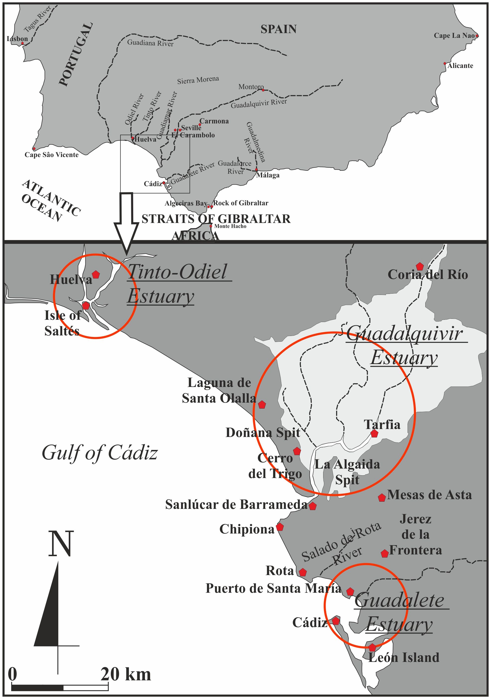
Figure 1 Southern Iberia.
The chief problem researchers faced was locating the remains of the presumed capital of such a kingdom, also named Tartessos. The richest sources to aid their efforts were the work of Greek archaeologist and geographer Pseudo-Scymnus (second century BCE), Greek geographer and ethnologist Strabo (late first century BCE), and, above all, the poem Ora Maritima by Roman author Rufus Festus Avienus (fourth century CE). These sources presented their own set of problems, however; the exegetical approach to these texts, though systematic and unrelenting, failed to produce a cogent theory about Tartessos, especially a hypothesis about the location of the city of Tartessos, that was confirmed archaeologically.
Following the Jerez symposium of 1968, a different paradigm for the subject of Tartessos replaced that established by Schulten and García y Bellido. In our view, the shift involved a local development of what Martin Bernal referred to in 1987 as the “Return of the Iron Age Phoenicians” challenging the “Hellenomania” that had dominated the literature since the nineteenth century.2 One of the defining methodological principles of this new paradigm, here referred to as “The Jerez Paradigm,” was to distrust all references to Tartessos found in the narratives from antiquity. Practitioners maintain that hypotheses about this subject should be inferred primarily, if not exclusively, from archaeological evidence, which they consider far more reliable than written accounts such as those of Avienus. The documentary value of Ora Maritima, particularly, was questioned by Schmitt (1978), De Hoz (1989), González Ponce (1995), and Marcotte (2000), who argued that Avienus’ poem is little more than a fourth-century CE literary construct.
It is our main objective in this article to make the case that such a substitution of the archaeological finds for the written accounts that have survived from Near Eastern and Classical antiquity, particularly Avienus’ Ora Maritima, was unnecessary. In addition, we aim to show that the shift raised more epistemological problems than those that it was reputedly aimed to solve. Many of these old problems, furthermore, remain unsettled; one of them, arguably the most salient and certainly the best known, is that of the location of the city of Tartessos.
It is our methodological stand that the most accurate representation of the polity of Tartessos, including the city of the same name, must be grounded in the articulation of every kind of reliable source available, from every applicable discipline, that is informed from a theoretical perspective that is open to the most insightful, comprehensive approaches to the understanding of archaic societies and early states. Consequently, we shall resort here to the philological analysis of the relevant texts preserved from antiquity, as well as to the historical analysis of the archaeological record that has accumulated since the late 1950s. Such a two-fold analysis, we hope, should enable readers to ponder on the epistemological validity of the ancient sources, including Avienus’ Ora Maritima, for attempting to understand Tartessos. In addition, as newly relevant evidence, we shall present the results of the geomorphological, chronological, and paleoenvironmental studies undertaken in southwest Iberia since the 1970s. Because these results allow for a reconstruction of landscapes in the coastal areas of the region that developed during the Holocene, that obtained for the first millennium BCE merits a novel understanding of the said texts, in particular the critical passages of Avienus’ Ora Maritima in respect of the realm and city of Tartessos; this novel comprehension affects the credibility of the poem as a historical source for the subject of Tartessos in combination with that of the other writings preserved from antiquity.
We shall begin our argument by introducing Avienus, perhaps less known by readers than other authors of antiquity, as well as his poem Ora Maritima. We shall follow by reviewing the subject of Tartessos as transmitted from antiquity, including the issue of the location of the city of Tartessos. Then we shall address the major aspects and results of both the Schulten-García y Bellido Paradigm and the Jerez Paradigm about the subject. While negative results of protracted research under these two paradigms could not mean necessarily that Avienus’ poem is unreliable as a historical source, some positive results of the same research may have agreed with parts of the Ora Maritima other than those related to the location of the city of Tartessos. Subsequently, we shall present the geomorphological, chronological, and paleoenvironmental evidence on which our reasons to concede the reliability of the poem chiefly lies. A discussion in the light of this evidence of the verses in Ora Maritima informing about the location of the city of Tartessos will ensue.
2 Materials and methods
2.1 Avienus’ poem Ora Maritima
Avienus’ Ora Maritima dates indeed from the fourth century CE. Furthermore, the manuscript of the poem handed down to the Print Age from the Roman period is incomplete. Yet the text contains references to the sea coasts of Iberia, including information about the city of Tartessos, that may be older than Pseudo-Scymnus’ and Strabo’s sources and are undoubtedly more detailed. Avienus names most of the authors of this information, some of whom (Hellanicus of Lesbos, the Ionian writer; Euctemon, the Athenian astronomer and geographer; and Herodotus) lived no fewer than seven hundred years before he did. Appropriately, Ora Maritima belongs in an intellectual context of revivalism of pre-Christian advancements in science, philosophy, and the arts.3
The edition of Ora Maritima on which we rely is that of Juan Gavala y Laborde and Francisco Torres,4 with a close eye kept upon Alfred Holder’s thorough critical edition of 1887 (Holder, 1887). We have attached a reproduction of this edition by Gavala and Torres as Appendix 1 to this article; see Supplementary Material. Gavala and Torres’s edition is based on a reconstruction of the metrical structure of the poem, as well as an analysis of the first edition (Venice, 1488); it also includes comparison of Abraham Ortellius’ manuscript copy, dated in the second half of the sixteenth century, with the modern editions of Blázquez (1923) and Schulten (1955a). In addition, Gavala and Torres drew upon state-of-the-art research on Iberian geomorphology in the 1950s.
Not much is known about Avienus beyond what he wrote about himself in the poem. He was of Etruscan descent, had senatorial rank, and became governor in Greece and northern Africa. Some years before composing Ora Maritima, he had translated into Latin a second-century CE book of world geography by Dionysius Periegetes, entitled by Avienus Descriptio orbis terrae, which includes references to the Atlantic seaboard of Europe and southern Iberia. After producing this translation and prior to writing Ora Maritima, Avienus visited Cádiz (Figure 1), finding it in a deplorable state, as though suffering the lingering effects of a major natural disaster. He remarked, however, that festivals in honor of Hercules were still celebrated.
It seems that Avienus used some form of one or more ancient portolan charts or rutters (πϵρίπλοῖ), travelogues (πϵρίοδοι) or a combination of the two as original sources for Ora Maritima. Rutters may indeed have been available to Greek navigators and tradesmen as early as the sixth century BCE, if not earlier.5 As suggested in the poem, an ancient rutter would have enabled seafarers to sail from the islands Sacra and Albionum (likely off northwest Iberia, if not in the North Atlantic)6 down to the Pillars of Hercules (Herculis Columnae) and, from there, along the coasts of southern and eastern Iberia on to the Phocaean colony of Marseilles. The same document7 would have also specified that an overland route connected a large gulf on the west coast of Iberia to the nearest point on the Tartessian littoral, in the southwest. With some effort, this trip could be made in four days, presumably by horseback (pede, as opposed to classibus; by land, rather than by sea). A second road extended this route to Málaga (Figure 1) and could be covered in five days.
The author or authors of Avienus’ unknown original source(s) are not clearly identified in the Ora Maritima. Some scholars8 have argued against the existence of an old rutter (or rutters) as a source for the work. Others, from the eighteenth century9 to the present,10 have insisted that the information upon which Avienus drew must have been very ancient. Critics Berthelot (1934, pp. 73, 101, 106) and González Ponce (1995, pp. 18, 118) have conceded this point. The poem frequently refers to Tartessos in the present tense and in many verses reads as though Avienus is citing or translating verbatim from a text or texts and intervenes at intervals to comment on specific parts of the original; we shall cite examples thereof below. In addition, there are several striking differences between the information provided about southwest Iberia and the Atlantic littoral in Avienus’ Descriptio orbis terrae and that contained in his Ora Maritima, which suggests that Avienus drew the latter from another source or sources. For instance, a cape named “Oestrymnis,” located somewhere on the Atlantic littoral, is mentioned in the Ora Maritima as a momentous turning point in the described route, yet is not recorded in Descriptio. Another instance concerns the name of the city of Cádiz, which is referred to by using the Phoenician Gadir as well as the Latin Gades in Descriptio but only as Gadir in Ora Maritima.
As noted above, Blázquez (1909, pp. 4, 12; Blázquez, 1923, pp. 54-60) reasoned that the mystery source might have been the work of the Carthaginian explorer Himilco, whose references to navigation conditions in the Atlantic are cited by Avienus in verses 117-129 and 382-415 of the Ora Maritima. Avienus himself mentions, in verse 414, his consultation of the “basest Carthaginian annals” (ab imis punicorum annalibus). By contrast, Schulten considered (Schulten, 1955b, pp. 16-17) the possibility that the source might be the little-known Euthymenes of Marseilles, who lived in the sixth century BCE and wrote about the lands of the western Mediterranean and northwest Africa. Alternatively, one might conjecture that the source was either Pausimachus of Samos or Bacoris of Rhodes, or perhaps both. In the preamble,11 Avienus mentions both authors, of whom nothing is known, together with Hellanicus, Euctemon, Herodotus, and other known sources.
Berthelot (1934, p. 109) and Pemán (1941, p. 23) entertained the idea that the original information might date from the early years of the sixth century BCE; the work contains references to Massilia (Marseilles), founded ca. 600 BCE, yet fails to register the colony of Ἐμπόριον(Emporion, Ampurias, Empúries) in the gulf of Rosas, in northeast Iberia, founded by people from Marseilles shortly thereafter.12 , 13
The ancient political, ethnic, and physical geography represented in the Ora Maritima includes unique data about the realm of Tartessos (Tartessius ager) beyond information about the location of the city (civitas). The text presents the realm as a multi-ethnic polity, spread from the Guadiana River in the west as far as the coast of the present-day province of Alicante in the northeast (Figure 1), with an additional foothold in northern Africa. Inhabitants of the realm included Cempsians, Cilbicenians, Etmaneans, Ileatians, and Massienians, as well as Tartessians. According to the text, the realm was well known to Phoenicians and Greeks, Phoenices, Punici, Libyphoenices, Graii, who had established trade outposts and even colonies in the land. For their part, Tartessians are said14 to sail regularly to the Insulae Oestrymnides, or Oestrymnices (near those named Sacra and Albionum)15 to trade for lead and tin, just as Phoenicians and Carthaginians would do in post-Tartessian times.16
2.2 Tartessos as transmitted from antiquity: a short review
In the fifth century BCE Herodotus would write about Tartessos (1.163-165, 4.152) that it was a kingdom in the far west of the known world that had traded with Greece in the seventh and sixth centuries BCE, mostly through the Ionian city-state of Phocaea. His words are worthy of quotation at length:17 , 18
1.163-65 as translated by Godley (1946-1949, II p. 355): “they [Samians sailing under the command of one Colaeus] then put out to sea from the island of [Platea] and would have voyaged to Egypt, but an easterly wind drove them from their course, and ceased not till they had passed through the Pillars of Heracles and came (by heaven’s providence) to Tartessus. Now this was at that time a virgin port; wherefore the Samians brought back from it so great a profit on their wares as no Greeks ever did of whom we have any exact knowledge, save only Sostratus of Aegina, son of Laodamas; with him none could vie. The Samians took six talents, the tenth part of their profit, and made therewith a bronze vessel, like an Argolic cauldron, with griffins’ heads projecting from the rim all round; this they set up in their temple of Here, supporting it with three colossal kneeling figures of bronze, each seven cubits high.” Brackets added.
4.152 in Godley’s translation as well (Godley, 1946-1949, I pp. 203-205): “Phocaeans were the earliest of the Greeks to make long sea-voyages: it was they who discovered the Adriatic Sea, and Tyrrhenia, and Iberia, and Tartessus, not sailing in round freight-ships but in fifty-oared vessels. When they came to Tartessus they made friends with the king of the Tartessians, whose name was Arganthonius; he ruled Tartessus for eighty years and lived an hundred and twenty. The Phocaeans so won this man’s friendship that he first entreated them to leave Ionia and settle in his country where they would; and then, when he could not persuade them to do that, and learnt from them how the Median [Persian] power was increasing, he gave them money to build a wall round their city therewith. Without a stint he gave it.” Brackets added.
Herodotus’ information can be deemed trustworthy because it is incidental to bigger, closer to home events that the Greek historian had chosen to address, namely the founding of Cyrene in Libya by Theraeans and the siege of Phocaea by Persian forces led by Harpagus. Archaeological evidence from both the island of Samos and the site of Phocaea has substantiated this information.19
In the seventh and sixth centuries BCE Greek merchants may have taken advantage of the possible disruption of Phoenician trade in the Mediterranean resulting from the pressures applied to the Phoenician metropolises by the Assyrian and later Babylonian empires; in 573 BCE Tyre, the leading Phoenician city-state, succumbed to a thirteen-year siege by the king of Babylon.20 As implied by Herodotus, at least Samian, Aeginan, and Phocaean tradesmen would navigate at the time to the distant land beyond the Gibraltar Straits, presumably in search of raw materials such as silver, gold, and tin, which the king of Tartessos or his representatives would procure for them from the indigenous population.21 Apparently, these trade relations culminated in a political and military alliance between Tartessos and Phocaea in the western Mediterranean that rivalled the alliance there between Phoenicians, Carthaginians, and Etruscans;22 as cited, Herodotus notes that the liaison with the city of Phocaea became so close that Arganthonios, king of Tartessos in the mid sixth century BCE, offered Phocaeans humanitarian and financial assistance to resist the expansion of the Persian Empire.
Parallel literatures from antiquity, including Hesiod’s Theogony,23 Pseudo-Apollodorus’ Bibliotheca,24 and Justin’s Epitome of Pompeius Trogus’ Philippic Histories,25 mention other kings of Tartessos from a more distant past. For an extensive discussion of these kings, all of whom belonging in at least three different traditions, see Maluquer de Motes (1970, pp. 37-50) and Caro-Baroja (1971). One of these other kings is Geryon, or Geryoneus, prominent in Greek narratives of the labors of the demigod Heracles, Roman Hercules. Another is Habis, lawgiver in an ancient mythical charter transmitted by Justin26 which suggests a social, political, and economic order that depended upon a hierarchy of cities. A social class of underprivileged people (plebs), who had been parceled out into seven cities (urbes), had to work (ministeria servilia) for the full citizens of the realm (populus), apparently living in another city that was paramount. Judging from a Roman inscription concerning the city of Hasta Regia,27 such an order was still in force in the early second century BCE.
The Greek presence in the western Mediterranean in the seventh and sixth centuries BCE may have induced a violent conflict for the Tartessian market between the Greeks and the Phoenicians, who had a longer history of trade and settlement in the region but were militarily weak at the time. In the central and western Mediterranean, Tyre was replaced by Carthage as center of Phoenician trade, colonization, and power;28 in southern Iberia and northern Morocco, the center may have been Cádiz,29 if not Carthage as well.30 According to Strabo and other authors,31 Phocaean Greeks founded a city (πόλις), μαινάκη (Mainákê), on the southern Mediterranean coast of Iberia, near or east of Málaga. The initiative, likely in the late seventh century BCE, midway through the reign of philhellene King Arganthonios in Tartessos, was perhaps also a way of circumventing the control of the Straits of Gibraltar by the Phoenicians of Cádiz or the Carthaginians. Some sixty or seventy years later, ca. 540 BCE, if Herodotus is to be trusted,32 a Phocaean fleet had to face a joint armada of Carthaginian and Etruscan war ships off Alalia, Corsica. Although the Phocaeans won the battle, they lost two-thirds of their ships and had to evacuate Alalia to attempt resettlement in Italy. By then, Phocaea, the metropolis, had fallen to the Persian expansion and King Arganthonios was dead.33 News of the kingdom of Tartessos stopped reaching the Greek-speaking world sometime thereafter.34 Archaeological evidence indicates that at least the material culture of Tartessos continued as far north as the middle Guadiana Valley till the late fifth or early fourth century BCE.35
Regular contact with sources from Classical antiquity would resume in the late third century BCE, because of The Second Punic War; by then, the realm of Tartessos was only a faint memory.36 The reason for the isolation of southwest Iberia in respect of Greek or Roman civilization for some three hundred years is a matter of debate.37
2.3 Location of the city of Tartessos in the writings of antiquity
The preserved traditions from antiquity have it that the political center (πόλις, pólis, civitas) as well as port of trade (ἐμπόριον, empórion) of Tartessos lay somewhere in the maritime region of present-day southwest Spain. As noted above, the specific sources needed for finding its precise location include Pseudo-Scymnus, Strabo, and Avienus, the last-mentioned being particularly informative. Pseudo-Scymnus (arguably Apollodorus of Athens)38 wrote39 that the “distinguished city” (ἐπιφανὴς πόλις) of Tartessos was reached “after having completed a two-day navigation” (‘ἡμϵρῶν δυοῖν τϵλέσαντι πλοῦν) westward from an indeterminate point that was probably either Mainákê or the Rock of Gibraltar, one of the “Pillars of Heracles” flanking the Gibraltar Straits. The day before their arrival at the city of Tartessos, mariners navigating this route would stop at the island of ‘Eρύθϵια (Erýtheia), which, according to Pseudo-Scymnus, swarmed with cattle herds and was inhabited by “western Ethiopians”; later that same day, the same mariners would harbor at the city of Cádiz. Pseudo-Scymnus drew largely from Ephorus of Cyme’s Universal History (fourth century BCE) and Eratosthenes’ Geography (third century BCE). It is apparent that either Ephorus or Eratosthenes, or perhaps both, relied on some form of rutter or travelogue from the fifth or sixth century BCE that is now lost.
Strabo cited fifth-century BCE Pherecydes of Athens to point out40 that “Erytheía,” as he named it, was a longer island, 100 stadia (some 18.5 km) long, the largest in the Cádiz archipelago, and that the city of Tartessos no longer existed in his time nor in that of his sources; it had been located on the isle formed by the two mouths that the river Baetis had at his time. Like other authors from the Roman period, Strabo understood that this river “Baetis,” so called by the Roman provincial administrators and settlers, the present-day Guadalquivir River, had been the Tartessos River. Strabo’s main sources were Greek scholars who had been to southern Iberia in the second and first centuries BCE, such as Polybius, Posidonius of Apamea, Artemidorus Ephesius, and Asclepiades of Myrleia,41 all or most of whom must have learned about “the distinguished city” of Tartessos from native oral tradition.
In Avienus’ Ora Maritima, the city of Tartessos appears located on Cartare insula (“the isle of Cartare,” a place-name of Phoenician etymology: “the isle of the city”), which was situated within the Tartessos River (Tartessus amnis). The rutter-like narrative in most of the poem42 suggests that this isle, visible from the sea, stood close to the mouth of the river. The river surrounded or held (ligat) the isle after flowing into a lake called Lacus Ligustinus.
The geography of the mouth of the river as described in the poem was complex.43 East of the isle of Cartare, three inlets branched off from the river into the hinterland. South of the isle, after apparently a sequential bifurcation within a delta (ore bis gemino, “through a twice two-fold outlet”), the east arm of the river joined the west arm; the re-joined course of the river then emptied into the ocean. A mountain or mountain range, Mons Argentarius (“Silvery,” or “Silver-rich,” “Mountain,” or “Mountain Range”), could be seen over the lake, or over the marshland (paludem incumbit), from the sea.44
Despite this description contained in Avienus’ poem, the precise location of the city of Tartessos generally eluded writers of the Roman period just as it does the scholars of today. While Strabo himself was unable to specify its precise position in relation to the two mouths of the river Baetis, Pomponius Mela, born in nearby Tingentera ca. 10 CE, contended45 that the city had stood upon Algeciras Bay, instead (Figure 1). Mela did confirm, however, Strabo’s description of the lower course of the river Baetis; he wrote46 that the river reached the ocean in the form of “two large distributary channels that flowed from a large lake that stood not far from the ocean, each of the channels being as large as the river itself before flowing into the lake.”47
Mela’s contemporary Pliny the Elder48 used the plural to refer to the area of the lower Baetis River: “Aestuaria Baetis” (the estuaries of the river Baetis);49 yet also placed the city of Tartessos upon Algeciras Bay, or in Cádiz, echoing a tradition first recorded in the first century BCE by Sallust50 and Cicero.51
Only a few features recorded in the Ora Maritima are readily recognizable today: the Guadiana River (as Ana amnis in verse 205), the old town of Cádiz (as Gadir oppidum in verse 267), and the Rock of Gibraltar (as saxum prominens Calpe in verses 343-344). The poem names cities, peoples, and rivers, as well as forests, mountains, and other landmarks, that are linguistic hapax legomena; these names appear in no other known texts concerning pre-Roman Iberia. Many or most of these names may bear witness to ancient regular contact with Greeks, whether from Greece itself or from Greek colonies in the Mediterranean, or both.52 There is, for instance, the enigmatic city of Herbi of verse 244, located in the narrative somewhere between the mouth of Ana amnis and the mouth of Tartessus amnis.53 In a clear case of juxtaposed texts in the Ora Maritima, Avienus comments54 that this city no longer existed in his time: it had been destroyed in “past times of wars,” possibly an allusion to the disturbances of the second century CE (or earlier) in southern Iberia. According to the Ora Maritima,55 Herbi lay near a coastal lagoon or marshland called Palus Erebaea or Etrephaea, from which a river, Hiberus amnis, flowed (inde manat) into the ocean. Near the lagoon also, a cape or range of hills (iugum) could be found that housed a “rich temple” (dives fanum) dedicated to the “Goddess of the Underworld” (Inferna Dea) and containing a crypt. Farther on (post), in the direction of the Straits of Gibraltar, stood Cartare insula and, next (inde) along the littoral, the “Mount (or Mountain Range) of Cassius” (Mons Cassius). Avienus comments56 that the Greek name for tin, in his rendition “cassiterum,” was coined after this feature. Mons Cassius was followed by the “Cape of the Temple” (Fani Prominens).
From Fani Prominens, the prospective mariner could make out from afar (eminus) the “citadel” (or “promontory”) of King Geryon (Gerontis Arx), which received the waters of “a wide river” (flumen amplum) that flowed into the nearby sea. Fani Prominens and Gerontis Arx flanked the entrance into Sinus Tartessius, the “Gulf of Tartessos.” It took one day to sail from the mouth of the river Hiberus to this site. Gerontis Arx stood by, or was located within, the oppidum of Gadir, the core establishment of the Phoenician colony of Cádiz. At this point, Avienus distances himself again from the unknown source, as in the verses on the city of Herbi or on Mons Cassius, to follow instead Sallust, Cicero, and Pliny the Elder in stating that the oppidum of Gadir was known in the past as Tartessus, the city of Tartessos. The establishment of Gadir, however, the reader should notice, was not located on an isle within a river, as specified elsewhere in the poem for the city of Tartessos,57 but on a sea island that formed part of an archipelago. Perhaps Avienus had a former political and trade center of the realm in mind. Alternatively, Gadir may have become a recurrent metonym in Roman scholarship for the memory of the ancient polity.58
Southeast toward the mainland (ad continentem) from the establishment of Gadir, Avienus continued,59 a “channel” (interfluum) five stadia wide (some 925 m) separated the establishment and Gerontis Arx from the island of Erythia. This Erythia must be the same as the 100-stadium island that Pherecydes of Athens had called ‘Eρυθϵία (Erytheía) rather than the smaller island of the same name (present-day León Island, Figure 2B) mentioned by Pseudo-Scymnus. To the west of Erythia lay another island, “consecrated to Venus Marina,” that contained a subterranean temple and an oracle.
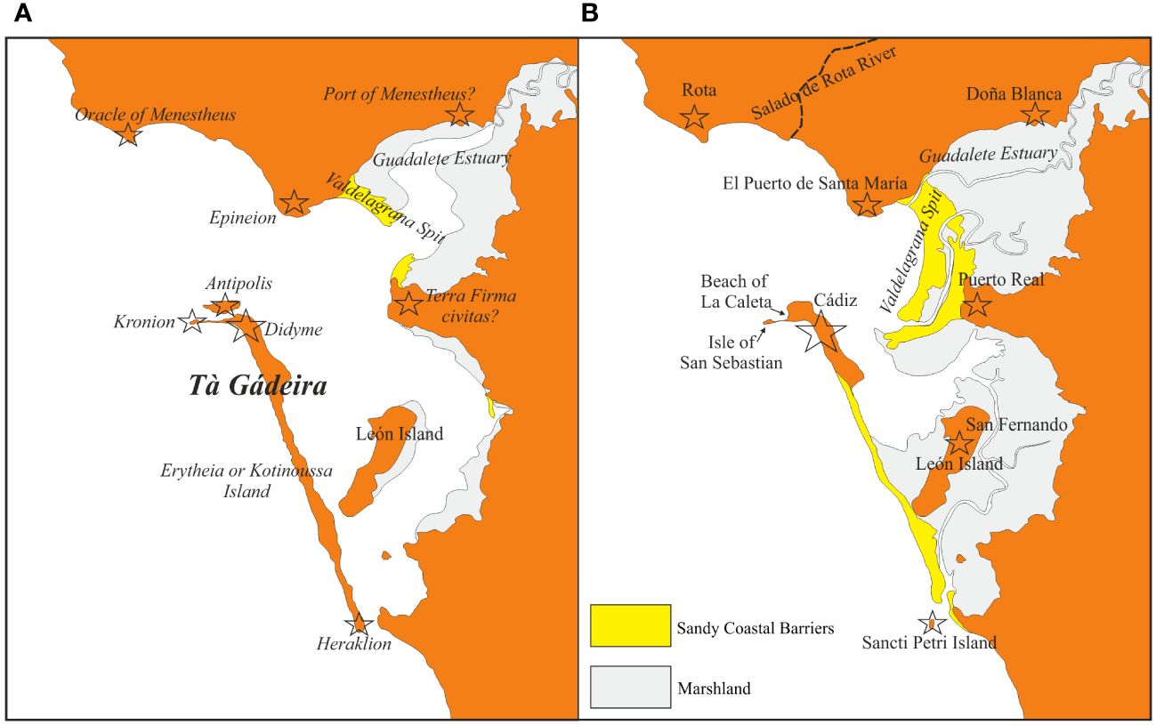
Figure 2 The islands and bay of Cádiz and their environs in the present and according to Strabo and Pliny the Elder [geomorphological data partially referred to in Alonso et al. (2015) and Dabrio et al. (2000)]. (A) According to Strabo and Pliny; (B) Present.
Such are the key place names in what Pemán (1941) referred to as the “Tartessian passage” in Avienus’ Ora Maritima, verses 241 to 342 in the poem, around which the controversy revolves.
2.4 Unfolding paradigms in Tartessian studies
Interpreting Avienus’ text, even if carefully analyzed in the light of other written sources for ancient Iberia, has always been problematic. Early in the twentieth century (1909, 1923) Blázquez, a geographer as well as a historian, conducted a thorough analysis of each of the sources to conclude that the remains of the city of Tartessos lay buried in the spit of Doñana, somewhere close to the Santa Olalla coastal lagoon, which he believed was a remnant of an ancient outlet of the Guadalquivir River (Figure 1). Schulten pursued this line of inquiry and, together with archaeologist George E. Bonsor, determined that the remains lay in the vicinity of Cerro del Trigo, where Roman-period structures and artifacts had surfaced.60 Also located on the spit of Doñana, this site lies some 12 km southeast of the Santa Olalla lagoon, near the present-day mouth of the Guadalquivir River (Figure 1). Like Blázquez before them, Schulten and Bonsor assumed that the coastlines of southwest Spain had changed significantly since Tartessian, and even Roman, times, which would account for much of the difficulty in interpreting the testimonies that have survived from antiquity. As we shall see, the current configuration of the Guadalquivir Estuary is the product of a long, complex process during the Holocene that saw a far larger estuary filled with sediments from the river Guadalquivir itself, convergent rivers such as the Guadiamar, and other forms of sediment generated by marine dynamics (Figure 1). In the 1920s, Schulten and Bonsor managed to test their hypothesis by jointly conducting excavations at the Cerro del Trigo site, with the help of cartographer A. Lammerer and geologist O. Jessen.61
Their hypothesis turned out to be wrong, however; the two scientists found no Tartessian remains below the Roman structures exposed at Cerro del Trigo, let alone remains of the city of Tartessos. Their failure prompted other researchers to use the same set of sources to devise alternative hypotheses, which concerned other sites (Figure 3). To mention the most remarkable instances: Fernández Amador de los Ríos (1925) pointed to the alluvial island of Tarfia, some 20 km up the Guadalquivir River from Cerro del Trigo; Arenas (1927) argued for the city of Huelva (Roman-period Onoba); Chocomeli (1940) and Martín de la Torre (1940) chose Mesas de Asta, the site of the pre-Roman city of Hasta Regia located close to Jerez de La Frontera. Pemán (1941) welcomed the hypothesis of Mesas de Asta, though also offered Jerez de La Frontera itself as well as the formerly island of León, near Cádiz, as possible locations. García y Bellido (1944) proposed the isle of Saltés, in the Tinto-Odiel Estuary (Figure 3). Barbadillo-Delgado (1951) and Loïc Menanteau (in Palacios, 1981) indicated the spit of La Algaida, across the mouth of the Guadalquivir River from Cerro del Trigo. Gavala y Laborde (1959a, b) suggested Cádiz. Berthelot (1934) and Blanco-Freijeiro (1979) suggested Seville. Of these hypotheses, only those concerning the site of Mesas de Asta were archaeologically tested by Manuel Esteve Guerrero in a manner comparable with that of Schulten and Bonsor at Cerro del Trigo (Esteve Guerrero, 1969). Excavations at Mesas de Asta yielded evidence of Tartessian occupation among a long series of occupations that began as early as the Copper Age or Chalcolithic and continued through to the Islamic period. Esteve Guerrero (1969, p. 118) considered as Tartessian occupation the remains of the first half of the first millennium BCE. However, the quantity of remains found at the site from such a period was ultimately disappointing.
Figure 3 Hypothesized locations of the city of Tartessos.
In the late 1950s, archaeology in southern Spain entered a long overdue period of sustained growth which justified the call for an international symposium about Tartessos. Convened at Jerez de La Frontera in September, 1968 the symposium gave form to a new paradigm in Tartessian Studies, the afore-mentioned Jerez Paradigm. The accumulated literature since is vast; the references cited in recent publications may serve for guidance.62 Especially notable scholarly landmarks were a collective work on the subject in the late 1980s led by Aubet (1989), the meeting commemorating the 25th anniversary of the 1968 symposium (BUC, Biblioteca de Urbanismo y Cultura, Ayuntamiento de Jerez de la Frontera, 1995), the meeting commemorating the 50th anniversary of the treasure-trove find of El Carambolo, near Seville, in 1958 (De La Bandera Romero and Ferrer Albelda, 2010), and an international meeting held in Huelva in 2011 (Campos and Alvar, 2013). However, these developments, though unprecedented, rested primarily on accidental finds, such as that at El Carambolo, and on archaeological salvage operations rather than on problem-oriented research projects. The evidence became thus skewed in favor of the places where the finds surfaced or were excavated.63 Furthermore, the interpretation of finds was largely shaped by a methodological bias set against using information contained in the narratives from antiquity; even Old Testament references to Phoenician and Israelite commercial expeditions to the land of Tarshish were neglected, if not dismissed.64
For brevity, the contributions in the extensive literature since the late 1950s can be conceived of as covering a spectrum defined by a pair of ideal types of opposing views in a dialectic. On one side of the spectrum,65 Tartessos is represented as only the Greek name for an area in southwest Iberia that Phoenician merchants, craftsmen, farmers, priests, and administrators, particularly those from the city-state of Tyre, inhabited, organized, and exploited from the ninth or eighth century BCE onwards. Additional foreign influence came from the peoples of Atlantic Europe. The political and economic center of this colonized new world was, according to this view, the Phoenician city of Cádiz. On the other side of the spectrum,66 Tartessos is portrayed as a political world in southwest Iberia in the form of an aristocratic monarchy or a chiefdom, or a number thereof. Clustering around the Tinto-Odiel estuary and open to the influence of peoples from north-western Europe, such a polity, or polities, emerged from Bronze Age lineage-based communities or chieftainships in the ninth or eighth century BCE. Notwithstanding this indigenous pediment, Tartessos, in this different view, is represented as also shaped, in large part, by trade, immigration, and innovations from the Near East, which profoundly affected distinct realms of social life in the land: technology, house design, food procurement, social and political organization, even religion and funerary ritual.67
In studying Tartessos, however, doubting as a methodological principle the reliability of the written sources for this ancient Iberian polity preserved from antiquity poses the risk of severing Tartessos from all, or nearly all, historical association with Greece and the Old Testament and, thereby, the risk of reducing the representation of Tartessos to little more than inferences from ninth- to fifth-century BCE material remains; consequently, the discussion of the non-material aspects of the case, such as the social, political, and economic organization, is deprived of a firm ground. Judging by the results of our research, such is, with some exceptions mentioned below, what has effectively happened over the past sixty years or so of Tartessian studies under the Jerez Paradigm. As most of the archaeological finds have been Phoenician or Phoenician-inspired, they have been attributed to an archaeologically defined culture that embodied an Orientalizing Period in the late prehistory and early history of southwest Iberia.
Ironically, the neglected authors of antiquity, including Strabo and Avienus himself, clearly attest to Phoenician presence and influence in southern Iberia in the first half of the first millennium BCE, if not earlier. Their testimony highlights the question of the value of these authors as historical sources for Tartessos.
2.5 The littoral of Southwest Iberia during the middle and late Holocene
As Blázquez, Schulten, and Bonsor suspected, coastlines are the outcome of complex geodynamic processes interacting with one another on land as well in the sea over hundreds or thousands of years. The natural phenomena concerned are the sea waves, the tidal cycle, the river discharges, the climatic setting, and the effects of neotectonics. The river discharges are conditioned by the sea-level oscillations, which depend on the climatic setting. Ever since the Neolithic period, human activity must be factored in as well. The complex, interactive processes involving all these variables have short-, mid-, and long-term effects. Short-term effects may include noticeable geographic changes;68 the Gulf of Cádiz is a clear case in point.69 Although its present-day configuration is largely the result of a transgression of the Atlantic Ocean that began some 15,000 years ago, in the final phase of the last ice age, the ocean in the gulf reached its highest level some 6,500 to 5,500 years ago, when it became comparatively stable.70 In the process, this marine upsurge transformed a number of fluvial valleys into wide estuaries flooded by the ocean. Thereafter, these estuaries underwent changes of their own.
The geomorphological and biological studies conducted in southwest Iberia since the 1970s have made it possible to establish a model for the geographical and environmental transformations in the area since the Postglacial Maximum of the Atlantic. Evidence for these transformations results from analyzing satellite images, aerial photographs, historical documents, archaeological remains, geomorphic features of the landscape (e.g., littoral strands, dune systems, sedimentary lags, erosive morphologies), and cores of sedimentation extracted from the Holocene soils identified in the area. Drilled to different depths, from just a few centimeters to dozens of meters, such cores are microscopically examined for lithostratigraphic contents, macro- and micro-faunal remains, pollen and non-pollen palynomorphs, charcoal particles, and samples for chronometric dating determinations.
Some 4,200 years ago, the climatic and environmental setting of southwest Iberia changed rapidly to more arid conditions.71 Referred to in the specialized literature as “the 4.2 kyr cal BP event” (Magny, 1993, 2004) or “Bond event 3” (Bond et al., 2001), this turning point to a different climatic and environmental stability, lasting till the present age of global warming, has been detected elsewhere in the Iberian Peninsula as well as in other regions of the northern hemisphere.72 Geologists, paleo-environmentalists, and prehistorians73 have all singled this turning point out as marking the transition from the Middle to the Late Holocene.
In southwest Iberia, the predominant climate conditions in the late Holocene can be regarded as fitting those of the Mediterranean type: in short, warm, dry summers alternating with mild, rainy autumns and winters. Most frequent winds come from the southwest, where the ocean is.74 As these winds condition wave regime, beach deposits, and dune formation, they play a major role in geomorphologically shaping the littoral; more specifically, they generate a coastal current that drifts from west to east, causing sand deposits on the shores to protrude in the same direction and eventually build into spits.
The maximum tidal range in the annual cycle is 3.86 m, the average range being approximately 2 m. Tides of these amplitudes have made the littoral of the Iberian side of the Gulf of Cádiz to be classified as semidiurnal mesotidal.75
Neo-tectonic forces press extant geological formations, including spits and dune systems on the coasts and sedimentary accumulations in the estuaries, to subside; by the same process, such formations may ultimately be covered by subsequent formations or by the ocean.76 The Iberian Peninsula constitutes the southwestern corner of the continental component of the Eurasian plate, where it faces the northern boundary of the African plate. The Azores-Gibraltar fault zone lies in between. Structurally, the present geological configuration of the gulf is the result of the convergence motion of both plates, which is a dextral strike-slip motion along the Azores-Gibraltar plate boundary.77 Besides causing subsidence, the neo-tectonic pressures periodically trigger earthquakes and tsunamis; in southwest Iberia, geologists have identified sedimentary and geomorphic traces of large tsunamis that impinged upon the littoral over the past five thousand years in recurrence cycles of four hundred to a thousand years.78
The estuaries of southwest Iberia exhibit at present extensive spits and marshes. As with the rest of formations in the region, they are the final product of five to six millennia of transformations in the wide estuaries that existed at the time of the Postglacial Maximum and thus became paleo-estuaries eventually. Because much of the areas of these paleo-estuaries are still subject to the tidal cycle, they are distinguished as marshland, i. e., tidal marshland, from the more recent lagoons and estuaries formed in those areas. Note, therefore, the difference between a paleo-estuary, or present-day marshland in the lower course of a fluvial basin, and an estuary, which is the current formation in the coastal landscape. From west to east, the largest paleo-estuaries are those of the rivers Tinto-Odiel, Guadalquivir, and Guadalete (Figures 4–6). Of the three, the Guadalquivir paleo-estuary is, by far, the most extensive. As the principal fluvial artery of southern Iberia, the Guadalquivir River stands first in the region’s hydrological system. A measure of the high energy of its present dynamics is that flow rates can be as high as 5000 m3 per second.79 Upon entering the area of its paleo-estuary, south of the latitude of Coria del Río (Figure 5), the river distributes its current among winding meander-forming channels that, farther downstream, converge into the single present-day mouth by the town of Sanlúcar de Barrameda (Figure 1). The channels, in turn, receive the waters of tributary rivers, such as Guadiamar and Arroyo de La Rocina (Figure 5D).
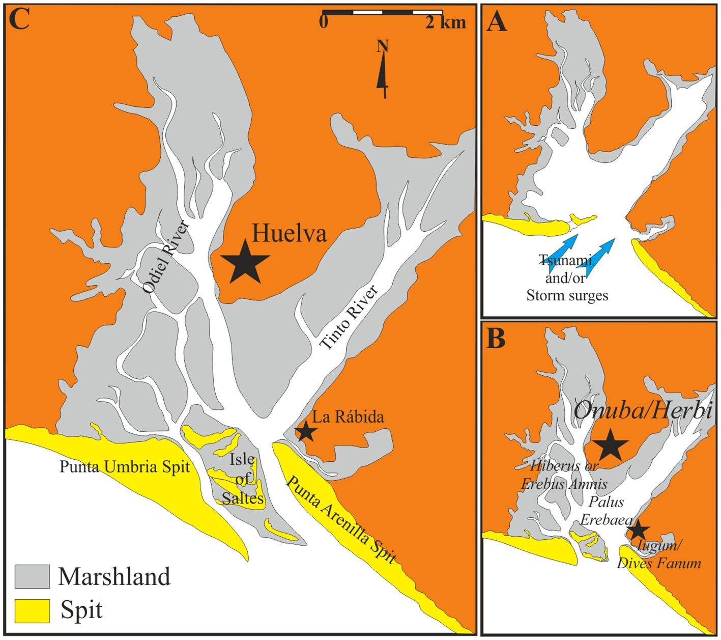
Figure 4 Geomorphology of the Tinto-Odiel Estuary and moments of its paleo-geographical evolution since ca. 1200 BCE [altered from Rodríguez-Vidal (1987), Dabrio et al. (2000), and Morales et al. (2008)]. (A) ca. 1200-900 BCE; (B) ca. 200 BCE-100 CE; (C) Present.
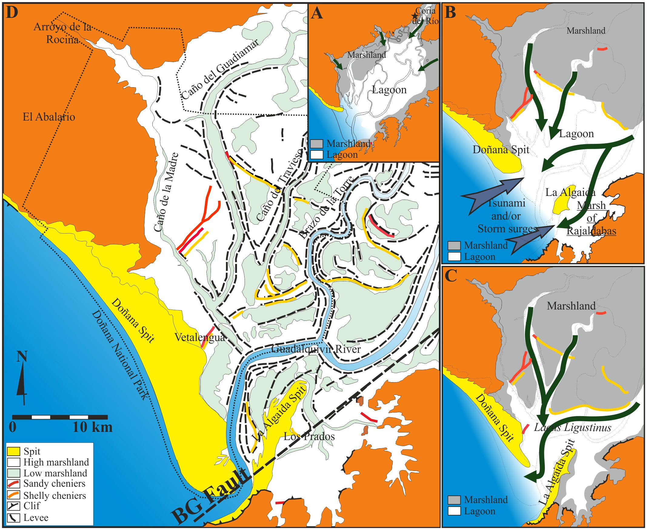
Figure 5 Geomorphology of the Guadalquivir Estuary and moments of its paleo-geographical evolution since ca. 3500 BCE [altered from Rodríguez-Ramírez and Yáñez (2008) and Rodríguez-Ramírez et al. (2014, 2015, 2016)]. (A) ca. 3500-3000 BCE; (B) ca. 1200-900 BCE; (C) ca. 100 BCE-100 CE; (D) Present.
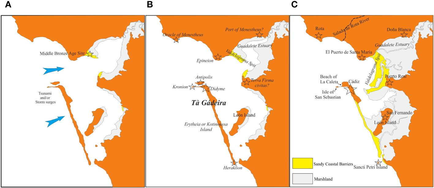
Figure 6 Geomorphology of the Bay of Cádiz and Guadalete Estuary and moments of their paleo-geographical evolution since ca. 1200 BCE [altered from Rodríguez-Ramírez et al. (2016)] (A) ca. 1200 BCE; (B) ca. 600 BCE-100 CE; (C) Present.
Aside from these tributary rivers and channels and the present-day outlet by Sanlúcar de Barrameda, the extension of the Guadalquivir paleo-estuary comprehends some 180,000 ha of tidal marshland; two spits, Doñana and La Algaida, separate it from the ocean. By featuring extensive dune morphologies developed over much of their surface during the Late Holocene, these two spits make up the largest system of sandy barriers on the littoral of southwest Iberia.80 Doñana lies at the west bank of the estuary; it is roughly 25 km long and 7 km wide and has a northwest-southeast orientation. La Algaida stands at the east bank; it is about 10 km long and 2.5 km wide and has a south-north orientation. Other conditions in the area being constant, these two spits tend to extend ever farther and, thereby, to increasingly narrow the outlet of the river: a process which facilitates fluvial sedimentation in the estuary as well as expansion and subsequent infilling of the marshland in the lower basin of the river. In between the two spits, by contrast, runs the Lower Guadalquivir River Fault (BGF), linked to the Azores-Gibraltar plate boundary with a southwest-northeast orientation (Figure 5D). North of this fault, the ground tends to subside, which helps the river flow smoothly and discharge its load offshore.
3 The accrued philological, archaeological, geomorphological, and paleoenvironmental evidence
3.1 The limitations of the Jerez paradigm
As noted, Phoenician presence and influence in southern Iberia in the first half of the first millennium BCE are duly mentioned by many an author of antiquity. To start with Strabo, it was this ethnologist-cum-geographer who, as mentioned above, flatly called attention to Phoenician settlement in southern Iberia from before the days of Homer and who remarked on Cádiz’s long-established monopoly of the Atlantic tin route by the time of the Roman rule. Furthermore, Strabo was one of the authors who echoed the tradition of the exploits of the hero Heracles in the far west of the known world, some of them concerning Tartessos; in antiquity such exploits came to be related to those of a character in Near Eastern mythology, Melkarth, in Phoenician Iberia.
In Pseudo-Apollodorus’ rendition of the Heracles story,81 the son of Zeus and the mortal Alcmene is ordered by Eurystheus, king of Tyrins and Mycenae, to steal for him King Geryon’s cattle. As the story goes, Heracles set out for the western end of the Mediterranean Sea and, after passing through Europe and Libya, reached his destination, the entrance to Geryon’s kingdom. There he erected two pillars over against each other as evidence of his journey; they marked the boundaries of Libya and Europe, as well as the gateway to the ocean. Heracles then crossed to the ocean through the entrance, present-day Gibraltar Straits, in a golden goblet borrowed by the Sun to reach an island known as ’Eρύθϵια (Erýtheia), “now called Γάδϵιρα (Gádeira),” Pseudo-Apollodorus remarks, where Heracles faced Geryon’s herdsman, Eurytion, and his watchdog, Orthus. He killed them both and stole the herd of cattle. Heracles then confronted Geryon by the River Anthemus. He killed him, too; thereafter, “having sailed across to Tartessos” (διαπλϵύσας ϵìς ταρτησσòν), presumably Geryon’s court, Heracles gave back the golden goblet to the Sun and returned to Greece by way of the Pyrenees, the Ligurian coast, Italy, Sicily, the Ionian Sea, and Thrace.
According to the poet Stesichorus of Himera (late seventh century to mid sixth century BCE), quoted by Strabo,82 Geryon (or perhaps his herdsman, Eurytion)83 had been born in a cave “by the boundless springs,” or, perhaps more accurately, “boundless streams, or waters” (“παρὰ παγὰς ἀπϵίρονας”), “of silver-rich roots” (ἀργυρορίζους”) of the river Tartessos, and “almost opposite” (“σχεδòν ἀντιπέρας”) to “the renowned island called ‘’Eρυθεία (Erytheía),” where Heracles would land. To cite Strabo’s words, “σχεδὸν ἀντιπέρας κλεινᾶς ’Ερυθείας Tαρτησσοῦ ποταμου παρὰ παγὰς ἀπϵίρονας ἀργυρορίζους ἐν κϵυθμῶνι πέτρας.”
Identifying the river Tartessos is a problem closely related to that of locating the city of Tartessos, as we shall see. This problem can be safely ignored for the moment, except for noting the repeated statement in the writings of antiquity that the river Tartessos emptied into the Atlantic Ocean. Strabo’s quotation of Stesichorus’ words comes from Laserre, 1966 edition, with full critical apparatus, of Strabo’s books 3 and 4 of his Geographical Treatise.84 In the 1960s, fragments of Stesichorus’ lost poem ‘H Γηρυονίς (Geryoneis) were recognized in papyri of the Oxyrhynchus Collection at Oxford University.85 Although analysis of this material helped set Strabo’s quotation in its proper textual and literary context, it failed to result in a significant, uncontested emendation of Strabo’s text as cited.86 Our interpretation of this text follows that of Page (1973, p. 148), De Hoz (1989, p. 27), and Davies and Finglass (2014, p. 262). We understand the phrase Tαρτησσοῦ ποταμου παρὰ παγὰς ἀπϵίρονας ἀργυρορίζους as more accurately to mean “by the boundless streams, or waters, of silver-rich roots, of the river Tartessos,” than “by the boundless springs, of silver-rich roots, of the river Tartessos.” Three reasons warrant this interpretation. Firstly, the plural noun παγαί, or πηγαί, denotes “waters” or “streams” as well as “springs,” at least in works of authors such as Homer, Aeschylus, Sophocles, and Euripides.87 Secondly, the nouns παγαί and ’Eρυθϵία appear to form in the text an apposition, as they have the same referent: Geryon or Eurytion; Strabo’s quotation suggests that the παγαί of the river Tartessos, by which Geryon or Eurytion was born, were near ’Eρυθϵία instead of near the headwaters of the river. ’Eρυθϵία is the island at which, in Pseudo-Apollodorus’ narrative, Heracles arrived after entering the ocean with the intent of stealing Geryon’s cattle. And thirdly, the meaning of the rare adjective ἀργυρορίζους, “of silver-rich roots,” for the noun παγὰς would appear as almost awkwardly redundant if the meaning of παγαί were “springs”; this difficulty is removed if παγαί is taken to denote “streams” or “waters” instead.88
Stesichorus’ lifetime roughly coincides with the period in which Greeks’ relations with the kingdom of Tartessos were, according to Herodotus, the closest. These relations may have provided the circumstances under which the story of Heracles and Geryon came to be known in Greek Sicily by Stesichorus’ time. Himera had been founded in ca. 649 BCE by Chalcidians from Zancle, upon the straits of Messina, and later peopled by settlers from Syracuse as well. Zancle had been founded by Chalcidians from Chalcis, on the island of Euboea, and by Chalcidians from Cumae, in the Bay of Naples.89 Located on the north coast of Sicily, Himera offered a convenient position on the long-distance route to the Tyrrhenian Sea and the western Mediterranean from the Aegean and eastern Greece which Chalcidians shared with Phocaeans;90 furthermore, Himera was among the earliest cities to coin with silver, arguably procured from southwest Iberia.91
The story of Heracles and Geryon, however, may have circulated round Sicily and other regions of the Greek world much earlier, to judge from archaeological evidence of communication between southwest Iberia, Sicily, and elsewhere in the Mediterranean from the tenth to the eighth century BCE;92 also from Hesiod’s reference to the story in his Theogony.93 As the tradition included Heracles’ stay in Sicily on his return to Greece with Geryon’s cattle, it may have been known in Sicily from earlier still, in Mycenaean times. Archaeological remains from the Mycenaean period have been discovered in the valley of the Guadalquivir River, as well as in Sicily.94
Coded as a myth, the tradition may have been played as drama in festivals in the island that commemorated Heracles or Geryon, or both; in these festivals Stesichorus himself or, more likely, a chorus would recite and sing the Geryoneis.95 In the sixth century BCE, the tradition was popular in Sicily to the extent that Greek political leaders used it to make military initiatives against natives and the Phoenicians that had settled in western Sicily legitimate.96
As noted above, Strabo, elsewhere in his Treatise97 and quoting Pherecydes of Athens, commented that ’Eρυθεία was a 100-stadium long island that housed the core of the multi-sited city community (πόλις) of Cádiz, which Strabo appropriately referred to as “τὰ Γάδϵιρα,” literally “The Cadizes” (Figure 2A). Strabo cautioned his readers that other authors had written that ’Eρυθϵία was a different island, smaller than, and parallel to, the 100-stadium long island. According to García y Bellido (1947, p. 191), this smaller island is likely a reference to what is known in modern times as “isla de León” or “isla de San Fernando” (Figure 2B). Strabo remarked that fat cattle grazed on the lush pastures of this smaller island and that one stadium (some 185 m) separated one island from the other.
Timaeus of Tauromenium referred to the 100-stadium island as “Kοτινοῦσσα” (Kotinoûssa) because of the many wild olive trees grown in it.98 At the north-western tip of this long island, close to the core settlement of the city community (“Διδύμη,” Didýmê, “double,” “twofold” or “twin”), Strabo specified, stood a temple for the worship of Kρόνος (Kronos): τò Kρóνιον (the Kronion). Hesiod99 represents this character (Saturn, for the Romans) as the king of the Titans who ruled mankind during its golden age, before the time of the Gods.
In front of the long island, toward the north, according to Strabo, lay a third island, the smallest of the archipelago (Figure 2A), where the ἀντίπολις (antípolis, “city opposite”) of the city community stood.
In addition, Strabo wrote that settlers from the city could be found somewhere on the mainland. A few decades before his time, ca. 40 BCE, a new port, τὸ επίνειον (Tò epíneion), had been built across the bay, probably where El Puerto de Santa María now stands, near the present-day mouth of the Guadalete River (Figure 2A).
In connection with the Guadalete Estuary, Strabo also made mention100 of one “Port of Menestheus” (“ὁ Ϻϵνϵσθέως καλούμϵνος λιμήν”) named after the Athenian leader whose exploits in the Trojan War were recounted by Homer.101 This settlement, possibly the present-day site of Doña Blanca (Figure 2B),102 was arguably a port of Cádiz long before Strabo’s time.
Elsewhere on the littoral of the bay stood one “Oracle of Menestheus” (“τὸ μαντεῖoν Ϻϵνϵσθέως”) which, as Strabo’s narrative suggests, was at or near the present-day town of Rota (Figure 2B), where apparently Roman and pre-Roman temple remains surfaced in the seventeenth and nineteenth centuries.103 According to the early third century CE writer Flavius Philostratus the Athenian,104 Menestheus was the object of a cult among the citizens of Cádiz.
As remarked earlier, the Heracles of Greek traditions such as those recorded by Hesiod, Strabo, and Pseudo-Apollodorus came to be identified in antiquity with a demigod in Near Eastern mythology known as Melkarth. The cult of this demigod was tied to the agricultural cycle in Tyre from the tenth century BCE onward.105 The same mythology also represents Melkarth as a former divine king of Tyre who discovered the purple dye,106 a major source of wealth for the city, and organized and led daring commercial expeditions and colonization in the Mediterranean.107 , 108 Identifying Melkarth with Heracles may have originated in Cyprus,109 Sicily110 or Cádiz111 during the first half of the first millennium BCE. Possibly relying on Posidonius of Apamea, who spent some time in Cádiz in the early first century BCE, Strabo would inform112 that the city had been founded some years after the end of the Trojan War by Tyrian explorers who were searching the far west of the Mediterranean for the trail of Heracles,’ that is, Melkarth’s, exploits. The narrative of the crossing of the Gibraltar Straits by Heracles to steal Geryon’s cattle may be interpreted to mean that the Tyrians considered Melkarth to be either the first Easterner to open a sea route in the Mediterranean Basin and the Atlantic Ocean for trading with Tartessos, or the first to set the terms of trade with Tartessian authorities, or both. Strabo also wrote113 that, upon reaching the long island of Cádiz, the Tyrian explorers founded the city at its farthest end, while erecting the temple for Heracles, the Herákleion, at the nearest end (Figure 2A).
In the Old Testament, one encounters in The First Book of Kings, among other places, references to Tarshish, a faraway land across the Mediterranean Sea to which the joint trade fleets of King Solomon of Israel and King Hiram of Tyre sailed in search of “gold and silver, ivory, apes, and baboons.”114 Before the rise of the Jerez Paradigm,115 it was commonly understood that this Tarshish was the Old Hebrew name for the land and kingdom of Tartessos mentioned by Greek or Roman authors such as Herodotus. Archaeological evidence encountered in the city of Huelva, mentioned below, substantiates contacts with Phoenician seafarers and merchants as from the tenth century BCE.
In the case of Avienus, he clearly stated in his poem Ora Maritima that the realm of Tartessos had comprised Phoenices, Punici, Libyphoenices, and Graii, as well as other ethnic communities and Tartessians themselves. Did he really rely for his poem on one or more sixth century BCE sources, such as rutters (πϵρίπλοῖ), travelogues (πϵρίοδοι) or a combination of the two? Critic Marcotte posited (Marcotte, 2000, pp. 50-51, 92-93), somewhat incongruously, that while Pseudo-Scymnus may indeed have relied on a sixth century BCE Greek rutter to write about the Phocaean colony of Mainákê in his travelogue, Avienus used Pseudo-Scymnus’ travelogue as well as other later sources to produce what is little more than a fourth century CE literary construct about diverse subjects including the realm of Tartessos. This interpretation overlooks that the Ora Maritima presents far more information than what is provided in Pseudo-Scymnus’ travelogue and that Avienus cites at least one author, Himilco, who was clearly an early fifth-, if not a late sixth-, century BCE explorer.
González-Ponce was perhaps the chief proponent of the view that the Ora Maritima is basically a literary construct, a reflection of Avienus’ fondness for pre-Christian progress in science, philosophy, and the arts (González Ponce, 1995). He argued that only the creative archaism of a poet can account for (a) Avienus’ use of ethnic and place names that appear in the works of revered authors of a distant past instead of the names used by authors closer to his time (for example, the Greek ethnic names Hiberi and Tartessii instead of the Roman Hispani and Turdetani, respectively, or the place name Mons Cassius instead of Hareni Montes which is mentioned by Pliny the Elder); and, (b) his use of the hapax names, as in the case of the city of Herbi.
These are two rather dissimilar premises for the same conclusion. The former is unwarranted. The Ora Maritima contains usage of both Greek and Roman names, depending on the context of Avienus’ work. While in some parts of the Ora Maritima Avienus cites a source such as Himilco or Euctemon, in other parts he comments on a text, or texts, that he has copied down or translated into Latin. One example is the reference to the Phoenician colony of Gadir, which Avienus, like many a Roman author, opines that it was located where the city of Tartessos had stood.
Other instances in which González-Ponce identified creative archaism seem to merely reflect his own interpretation of place names in the poem. For example, by arguing that Avienus ought to have used the name Hareni Montes in lieu of Mons Cassius, González-Ponce is simply suggesting that Mons Cassius was a hillock, or a range thereof, located in the Doñana spit where Pliny the Elder placed Hareni Montes. As we shall see, our own evidence points farther east instead, to the hills that tower above Sanlúcar de Barrameda, by the present-day mouth of the Guadalquivir River (Figure 1).
The second premise of González-Ponce’s argument, which concerns the use of hapax names, implies a case of Argumentum ad Ignorantiam, a type of fallacy.116 The presence of hapax names is not in and of itself evidence of Avienus’ literary penchant for a merely aesthetic archaism, let alone outright evidence of lack of credibility of the Ora Maritima as a source for knowledge about Tartessos. The very rareness of the contents of the Ora Maritima (an unfamiliar ethnic, political geography as well as a sequence of singular names for places and geographical features) argues as much for authenticity as for lack of credibility.
González-Ponce recognized (González Ponce, 1995, pp. 110-113) that there are significant anomalies in the narrative structure of the Ora Maritima if the poem is treated analytically as an example of a “periplographic” genre in the literature of antiquity, which analysis González-Ponce himself did extensively in his essay to sustain his position against the reliability of the Ora Maritima as a historical source. However, even the actual existence of such a genre has been called into question.117
Partly due to the testimony of neglected authors such as Strabo, Pseudo-Apollodorus, and Avienus, and partly in response to new archaeological data and research tendencies since the 1990s, scholarship in recent decades demonstrates renewed interest in the old written sources for the early history of the area.118 As a consequence, scholars have resumed the practice of critically comparing archaeological evidence with literary sources.
New archaeological evidence includes the discovery of traces of Copper Age and Bronze Age settlement in the city of Cádiz.119 Researchers also have access to increasing numbers of Greek pottery fragments and fresh readings of The Iliad and The Odyssey that inform about Greek presence in the late second millennium BCE as well as the first millennium BCE in southern Iberia.120 These developments enrich an existing body of archaeological evidence from the periods covered by the pre-1968 narratives about Tartessos, including those of the Old Testament, which comprehends, for instance, two bronze Corinthian helmets from the seventh and sixth centuries BCE that were found close to Huelva and Jerez in the 1930s.121 The most remarkable finds since include the Mycenaean pottery sherds excavated at Montoro, located mid-way up the Guadalquivir River;122 the Phoenician, Cypriot, Greek, Sardinian, and Italic ceramics dated from the tenth to the early eighth century BCE recovered in the city of Huelva;123 an apparently Phoenician settlement site and necropolis, La Rebanadilla and Cortijo de San Isidro, some 8 km southwest of the city of Málaga, from the ninth century BCE;124 a third bronze Corinthian helmet, seemingly from the present-day mouth of the Guadalquivir River;125 and the Greek pottery from the archaic period found on the Málaga coast, in the city of Málaga itself, and in the city of Huelva (Figure 1).126 In addition, the city of Málaga has produced the imposing, subterranean tomb of an apparently prominent Greek warrior of the sixth century BCE,127 as well as a Greek inscription on sherds of a Samian cup from the seventh century BCE that is the oldest Greek inscription thus far found in Iberia.128 These finds lend support to the existence of a Phocaean settlement in what is now the city of Málaga or its vicinity, Mainákê, in the seventh and sixth centuries BCE, irrespective of its size and duration.129 In the city of Cádiz, at the site known as “Teatro cómico,” archaeologists have identified an early Phoenician settlement that was destroyed ca. 600 BCE.130 Destructions or abandonments from around 600 BCE or during the first half of the sixth century BCE, that is, the period in which relations between Tartessos and Greek traders and colonists were, according to Herodotus, closest, have also been recognized at the Phoenician settlements on the Málaga coast.131
As archaeological evidence accumulates, some scholars have over the past few decades reconsidered questions about the less material aspects of Tartessos as a social and political formation that the Jerez Paradigm is of little use to contemplate. These questions concern themes such as social and political structures and forms of production, distribution, and exchange, about which the written sources—e. g., Justin’s transmission of a mythical charter in connection with King Habis—offer some information. Recent reappraisals of the archaeological data animated by interest in these non-material themes make a case for a culturally hybrid, decentralized polity of Tartessos that interacted with the Phoenician colonies and later with Greek merchants in territorially differentiated, complex ways.132 Such a new concept of Tartessos, these scholars argue, justify that the ninth through to the fifth century BCE be regarded and approached as a Tartessic period on its own merit in the culture history of southwest Iberia rather than be merely classified as the local expression of the Orientalizing horizon that at the time extended across the Mediterranean.
Despite this progress, the representations of Tartessos that have emerged since the Jerez symposium, like many of those produced under the Schulten-García y Bellido Paradigm that preceded it, rest upon a model of the Tartessian landscape in southwest Iberia, and specifically of the littoral zone, that requires significant revision. Originating in the reconstructions of Blázquez (1909, 1923), Bonsor (2016, pp. 220-221), and Lammerer (in Schulten, 1945, maps III and IV), this model was later developed in the work of Gavala y Laborde in the Guadalete, Tinto-Odiel, and Guadalquivir paleo-estuaries. Gavala concluded (Gavala y Laborde, 1927, 1936, 1959a) that sedimentation in and filling of the paleo-estuaries in the Gulf of Cádiz during the Holocene was slow and gradual and that none of these environments could have sustained a significant human population, let alone a pre-industrial city, prior to the Middle Ages. Such a thesis conditioned the identification of some southwestern Spanish locations named in ancient sources, including Avienus’ Ora Maritima. For example, according to Gavala, the Guadalquivir paleo-estuary remained a massive body of marine water in Tartessian times; this contention led some scholars133 to posit that this paleo-estuary is represented by the “Gulf of Tartessos” (Sinus Tartessius) in the Ora Maritima.
However, Gavala’s research, like that of Blázquez, Bonsor, and Lammerer, predates the radiocarbon revolution, plate tectonics theory, and, obviously, the impact of novel research in coastal geomorphology and environments. Since the 1970s, the model has been rendered obsolete by new conclusions on the evolution of the littoral of southwest Iberia as framed by such scientific breakthroughs.134 It has become widely accepted that, after the Atlantic Ocean reached the Postglacial Maximum, some 6,500 to 5,500 years ago, the paleo-estuaries of the area were subject to the complex interactions, in cycles of different duration, of many natural variables (e.g., marine currents, ocean transgression, fluvial sedimentation, neo-tectonic movement), the effects of which combined with those resulting from paleo-environmental changes generated by anthropogenic activity.
Sooner or later, such a developing geomorphological and paleo-environmental fresh understanding of the evolution of the southwestern Iberian coastlines in the Holocene had to impinge upon the issue of the location of the city of Tartessos.
3.2 The littoral of Southwest Iberia in the middle and late Holocene: geomorphological and environmental transformations
Because of the jointly transformative action of the fluvial processes, the prevailing winds, the sea waves, the tide system, and the neo-tectonic pressures, the physical geography of the lower Guadalquivir River basin is at present significantly different from what it was in previous moments of the Middle and Late Holocene (Figure 5). The spits, for instance, did not always prograde at the same rate and with the same orientation, contrary to what Jessen (in Schulten, 1945, pp. 270-273) and Gavala y Laborde (1936) assumed in the first half of the twentieth century. These littoral formations were also, from time to time, subject to substantial erosion caused by high-energy, extreme wave events (EWEs), whether climate-related (cyclonic periods, violent storm surges) or generated by the neo-tectonic pressures (tsunamis). Specifically, as we shall see presently, recurrent very destructive EWEs significantly altered the landscape: they cut Doñana short, turned La Algaida into an island, and created tidal inlets that favored bifurcation of the river mouths in the paleo-estuary. These developments broadened and multiplied communication between the hydrological system in the paleo-estuary, on the one side, and the ocean, on the other. In addition, cheniers formed in the former (Figure 5D). “Chenier” is a technical term, borrowed from Louisiana French, for a relict beach ridge made of deposits of sand and shell with a littoral strand morphology overlying the clayey infilling of marshland. Cheniers indicate the location of ancient shorelines while signaling changes in paleo-environmental conditions, specifically in sediment supply, river discharge, sea level, frequency of storms, and extent of communication between an estuary and the sea.135
Subsidence north of the BGF fault was inordinately rapid from ca. 2000 BCE till the first centuries of the common era; this process invited large amounts of sediment to be deposited in the Guadalquivir Estuary as well as offshore. At the present-day mouth of the river, the accumulation of Holocene sedimentation is as thick as 100 m. As the subsidence started to decelerate, less than two thousand years ago, the present-day geomorphology of Doñana and La Algaida above sea level in the estuary began to form. Doñana, arching in a southeasterly direction, is nowadays just some 500 m, the width of the river mouth, away from Sanlúcar de Barrameda. North of this town, La Algaida is connected to the Mio-Pliocene deposits in the form of gentle hills, on which Sanlúcar de Barrameda stands, by means of a sand bridge or tombolo;136 as we shall see, this sand bridge blocks a former outlet of the paleo-estuary east of the spit (Figures 5D, 7, 8).
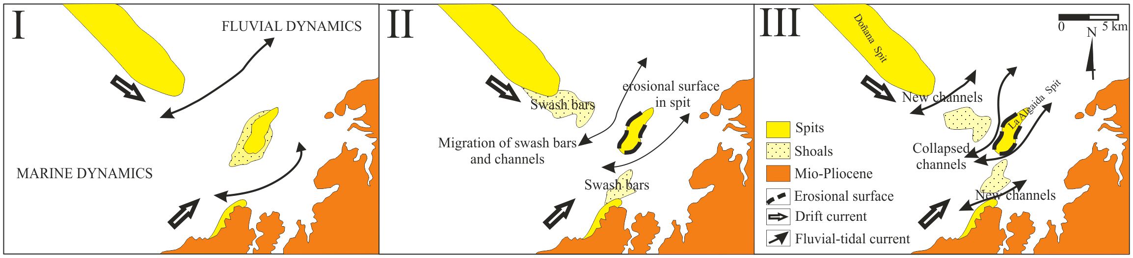
Figure 7 Evolution of ebb-tidal delta and inlet channels in the Guadalquivir mouth in connection with erosional incisions in the Doñana and Algaida spits following EWE C (altered from Rodríguez-Ramírez et al., 2016).
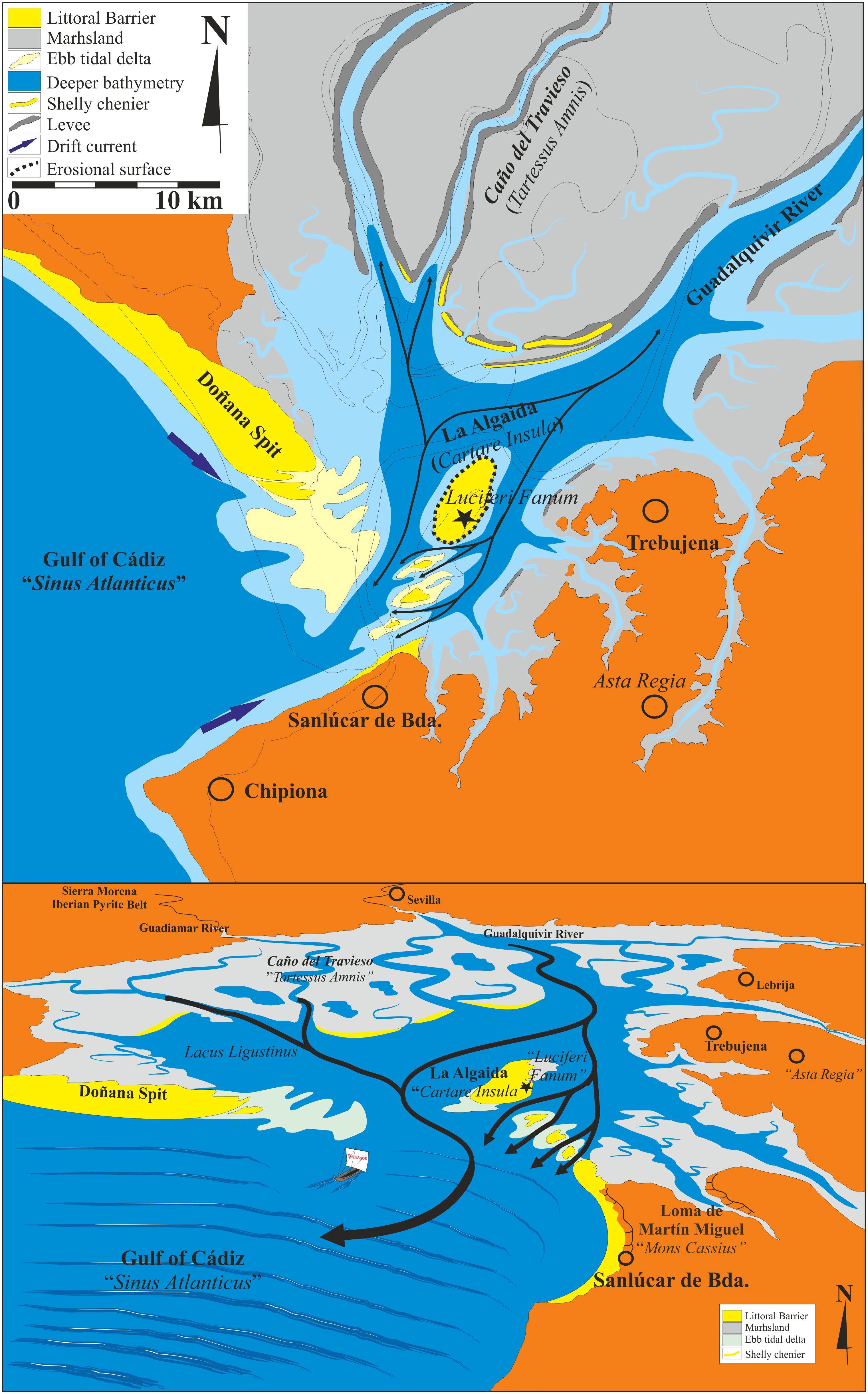
Figure 8 The river Tartessos (present-day Guadiamar-Travieso) and the isle of Cartare.
Correlation of sedimentary, radiocarbon, paleo-environmental, and geomorphic evidence from the Guadalquivir paleo-estuary with the same types of evidence from the other paleo-estuaries in the Gulf of Cádiz as well as from central Portugal suggests that at least four large EWEs hit the Guadalquivir paleo-estuary from the Chalcolithic through to the Roman period. For convenience, we shall refer to these events with the letters A, B, C, and D. EWE A occurred ca. 2000 BCE; EWE B, ca. 1550; EWE C, ca. 1150 BCE; and EWE D, sometime between 100 and 300 CE. On the Iberian side of the gulf, the impact of these marine transgressions was augmented by a gentle, low-lying coastal orography. Sea waves flooded the estuaries far inland and extensively. Analysis of cores extracted from the sedimentation in the paleo-estuaries have revealed depositional facies that are characteristic of such high-energy events: sandy sedimentary lags, built up on erosive bases, that contain massive accumulations of estuarine and marine shells, within clayey-sandy matrices that also include gravel and lithoclasts.137 Subsequent dynamics in the paleo-estuaries, fluvial as well as marine, caused these intrusive, extraneous deposits to accumulate in sandy and shelly cheniers, which conditioned the layout of newly formed tidal inlets; these inlets, in turn, defined the river mouths.
EWE A, ca. 2000 BCE, probably a tsunami, was the largest and most cataclysmic of all four EWEs as it transformed dramatically the geography of the estuary; for instance, it severely eroded Doñana.138 Furthermore, the event combined with the first effects of the 4.2 kyr cal BP event to usher in a period of depopulation of the area that lasted for about one thousand years.139
EWE B, ca. 1550 BCE, may have been a violent storm or a moderate tsunami, as suggested by the sedimentological and mostly estuarine faunal evidence retrieved from cores drilled in the Guadalquivir paleo-estuary. It seems that Doñana, which had recovered from EWE A, was little affected.140
EWE C, ca. 1150 BCE, probably a large tsunami, is at the origin of the physical geography of the Iberian littoral of the gulf as described in the Ora Maritima. In the paleo-estuary of the rivers Tinto and Odiel (Figure 4A), the sea waves left deposits as far inland as 16 km from the mouth of the Tinto River.141 In the Guadalquivir paleo-estuary, the event caused extensive erosion of Doñana as well as a rupture in La Algaida, then emerging, that transformed this new spit into an isle (Figure 5B).142 The marine transgression terminated a Middle Bronze Age settlement in the present-day marsh of Rajaldabas, near Trebujena (Figure 5B),143 and probably other settlements in the area as well, such as Lebrija (Figure 5B).144 Further southeast, in the bay of Cádiz and the Guadalete paleo-estuary, the impact of EWE C must have been significant as well, to judge from the abandonment of a Middle Bronze Age settlement recognized on the Valdelagrana spit (Figure 6A)145 and from geomorphological transformations in much of the sub-aerial extension of the Cádiz archipelago, by which the sandy formations (beaches and dunes) covering the rocky ledges of the islands shifted eastward.146
Following EWE C, the low-energy marine dynamics that had been at work in the gulf since the Postglacial Maximum resumed. In the Tinto-Odiel paleo-estuary, progradation of the spits Punta Umbría and Punta Arenilla began turning an open estuary into a semi-closed one that connected with the ocean by way of the wide outlet of the Odiel River (Figures 4A, B).147 In the Guadalquivir paleo-estuary, isolation from the sea proceeded at a faster pace. Doñana began expanding once more, this time more toward the southeast than before, generating and developing, in a few centuries, a coastal lagoon (Figures 5B, C); because of the extension of this spit, future EWEs hitting the area would impact the sea front far more than the inner sectors of the paleo-estuary.148 Paleo-environmental evidence in the sedimentation (namely, anthropogenic nitrophilous and anthropozoogenous herbs, coprophilous fungi, cereal pollen, macro-charcoal particles from anthropogenic fires) indicates that these inner sectors were resettled again, after about one thousand years of depopulation. Equipped with a Late Bronze Age material culture, the settlers lived off agriculture, livestock herding and raising and, possibly, fishing and shell-fishing.149 The isle of La Algaida took longer than Doñana to once again become a spit due to its position vis-à-vis the river and the ocean (Figure 7); this transformation may have lasted as much as one thousand five hundred years, up until the Roman imperial period, when the mouth of the Guadalquivir River would approximate its present form and the coastal lagoon would turn into the present-day marshes near the mouth (Figures 5C, D).150 Such a geomorphic setting, with La Algaida turned again into a spit, was likely the landscape that Avienus encountered when he visited Cádiz in the fourth century CE.
The coetaneous development of chenier systems in the Guadalquivir paleo-estuary is consistent with these changes.151 North of the present-day mouth of the river (Figure 5D), the marshes hold sandy chenier systems that are 50 to 100 m wide and 2.00 to 2.25 m above sea level. These chenier systems consist of overlapped strands that mark two ancient inlet channels of the ocean (or paleo-mouths of the river), which longitudinally traversed the area of the paleo-estuary till the Roman Imperial Period (Figure 5D). The westernmost paleo-mouth, defined by the littoral strands of Vetalengua, is flanked on the west side of the estuary by the Doñana spit and on the east side by the present-day spit of La Algaida. The second paleo-mouth, east of the first and defined by the littoral strands of Los Prados, is flanked on the west side by the present-day spit of La Algaida and on the east side by the hills of Sanlúcar de Barrameda (Figures 1, 5D). La Algaida was at the time the isle enclosed by the two river mouths. Placed in a tidal delta as well, such an isle would be subject to intense erosive processes, both fluvial and marine, as can be discerned from Figure 7. These processes would have modified its original extension and orientation.
In the Guadalete paleo-estuary (Figures 6A, B), the impact of EWE C was followed by the Valdelagrana spit resuming progradation toward the south, causing the Bay of Cádiz and the Guadalete Estuary to become ever smaller.152 Because of the marine dynamics and the EWEs themselves, the sandy formations in the southern half of the longest island of Cádiz would gradually move eastward, approaching the island of León. Such a development has been identified on the outer front of the bay as well, particularly from the Roman period onward.153 In addition, geophysical tests conducted in the old town of Cádiz have revealed that a smaller island lay north and north-west of an outlet of the Bay of Cádiz through to the present-day beach of La Caleta (Figure 6C).154
4 Discussion
4.1 The Tinto-Odiel Estuary in the First Millennium BCE
Judging from the reconstructions obtained for the geomorphological transformations in the largest estuaries on the Iberian side of the Gulf of Cádiz during the Late Holocene, it is not unreasonable to propose that the Tinto-Odiel Estuary that developed in the first half of the first millennium BCE was the lagoon referred to in the Ora Maritima as “Palus Erebaea” or “Etrephaea” (Figure 4B). Located some 45 km east of the lower Guadiana River (Ana amnis in the Ora Maritima), the western border of the realm of Tartessos, this lagoon was the nearest point to the Tartessian littoral from a large gulf on the west coast of Iberia that must, as Schulten and Gavala maintained, be the Tagus estuary (Figure 1). If so, then the river named “Hiberus” (or “Erebus,” according to Pemán’s interpretation, hence the adjective “Erebaea”) was the mouth of the Odiel River, which was much wider then than it is at present. The “iugum” holding a “rich temple” dedicated to a “Goddess of the Underworld” (Inferna Dea) was the promontory upon which the Christian monastery and shrine of La Rábida now stand (Figures 4B, C). These details coincide with the interpretation of Schulten and Gavala, as well as Pemán.
At the time, there was no coastal island hindering the flow of the Odiel River into the ocean, but instead a barrier: the Punta Umbría spit (Figure 4A). The present-day isle of Saltés at the easternmost end of this barrier, where in 1944 García y Bellido placed the city of Tartessos, holds sandy formations that appear disconnected from the barrier (Figure 4C). Although the earliest of these sandy formations dates to the first millennium BCE, its genesis has been explained by considering either the growth of the barrier, eventually cut through by a EWE in the middle, or second half, of the first millennium BCE,155 or a chenier-like accumulation of sands off the barrier caused by wave action.156 Regardless of their respective merits, both hypotheses imply high geo-dynamic instability at the easternmost end of the barrier, resulting in a fusion or a break of its parts as a function of shifting environmental conditions.
Standing near “Palus Erebaea,” the city of Herbi must have been at the site of the present-day city of Huelva, located at the junction of the rivers Odiel and Tinto (Figure 4B). As mentioned above, substantial quantities of Phoenician, Cypriot, Sardinian, Italic, and Greek pottery sherds from the tenth to the sixth century BCE have been found in the city of Huelva since the early 1980s.157 These findings, however, are insufficient evidence for ascertaining the location in Huelva of the city of Tartessos according to the Greek and Roman sources. Schulten (1945, p. 41) rightly regarded the city of Huelva as a strategic Tartessian port of trade where the Atlantic-Gulf of Cádiz-Mediterranean Sea route connected with the Tinto and Odiel fluvial routes leading to ore-rich western Sierra Morena158 (Figure 1). The city of Herbi may also have been the destination of the road from the Tagus estuary (Figure 1), which could be ridden with some effort in four days.
4.2 The Guadalquivir Estuary in the First Millennium BCE
In the case of the Guadalquivir Estuary, sedimentary, geomorphic, and chronological evidence of two river mouths from ca. 1150 BCE to ca. 350 CE substantiates the testimony offered in the works of Strabo, Mela, Pliny the Elder, and Avienus. As noted above, Strabo wrote that the river Baetis emptied into the ocean by means of two outlets and that the isle that stood in between likely held the remains of the city of Tartessos. Strabo’s specific sources for this information were probably Posidonius of Apamea or Artemidorus Ephesius, both of whom had visited southwestern Iberia early in the first century BCE.159 In the first century CE, Mela, a native of southern Iberia, reported that the river Baetis reached the ocean in the form of “two large distributary channels that flowed from a large lake that stood not far from the ocean, each of the channels being as large as the river itself before flowing into the lake.” By way of both distributaries, the fluvial current and tidal flows must have assured regular connection between the ocean and the lake. Pliny the Elder, Mela’s contemporary, used the plural to refer to the area of the lower Baetis River: Aestuaria Baetis.
Finally, Avienus wrote that a river “Tartessos” (Tartessus amnis), at first thought the same as the river Baetis, upon flowing into Lacus Ligustinus surrounded the isle of Cartare, where the city of Tartessos stood, before emptying into the ocean. Our reconstruction of the geomorphological transformations in the Guadalquivir paleo-estuary in the Late Holocene fits this description, in conjunction with those of Strabo, Mela, and Pliny the Elder (Figure 9). Lacus Ligustinus must be the “large lake” mentioned by Mela in reference to the lowest course of the river Baetis (Figure 5C); that is, the coastal lagoon generated in the paleo-estuary in the first millennium BCE by progradation of the Doñana spit. The Mons Argentarius of verse 291 of the Ora Maritima may, as Schulten suggested, be Cerro de San Cristóbal, near Grazalema. The silvery-looking mountaintop, locally known as El Torreón, can be readily identified from the paleo-estuary when watching over the horizon around sunrise (Figure 10). The isle of Cartare would be the spit of La Algaida, as one of the co-authors of this article, Antonio Rodríguez-Ramírez, hypothesized in 1996;160 the spit of La Algaida was an isle from ca. 1150 BCE to the Roman Imperial Period.

Figure 9 Paleo-geography of the inlets and outlets of the Guadiamar-Guadalquivir Estuary ca. 600 BCE as inferred from sedimentary, geomorphological, chronological, and philological evidence: (A) in total perspective of SW Spain; (B) for inlets 1 (Salado de Lebrija), 2 (Caño de Jerez) and 3 (Marisma de Rajaldabas); (C) for inlets a (Marisma del Conejo), b (Arroyo Rematacaudales) and c (Marisma de La Majada Vieja).
Figure 10 View of El Torreón (Mons Argentarius), mountaintop of Cerro de San Cristóbal in Sierra de Grazalema, from the Guadalquivir marshland plain (photograph by Antonio Rodríguez-Ramírez).
The river Tartessos would be either the present-day Guadalquivir River or the Guadiamar River (Figure 9). The Ora Maritima better substantiates the case for the latter. The Guadiamar River rises north of the Guadalquivir paleo-estuary in the ore-rich highlands of western Sierra Morena, where copper, silver, and lead have been extracted and wrought since the Chalcolithic.161 Such mineral wealth is one of the reasons that the land of Tartessos was well known in the eastern Mediterranean. Up until the nineteenth century, the Guadiamar River flowed across the area of the Guadalquivir paleo-estuary through today’s relict Travieso channel (Figure 9A).162 Stesichorus of Himera, it will be recalled, wrote, as cited by Strabo, that the Tartessos River had “silver-rich roots.” Avienus stated163 that the rapid, swirling waters of the Tartessos River flowed as far south as to reaching the walls of the city of Tartessos. Thus, the three inlets mentioned in the Ora Maritima as branching off from the river eastward into the hinterland at about the latitude of the isle of Cartare would be present-day Marisma del Conejo, Arroyo Rematacaudales, and Marisma de La Majada Vieja. These three marshes or brooks are located between the Cerro de Gibraltar164 to the north and the Cerro del Palmar to the south (Figures 9A, C). Alternatively, on a larger-scale map, the three inlets would be the present-day creeks Salado de Lebrija and Caño de Jerez and the marsh Marisma de Rajaldabas, between Las Cabezas de San Juan to the north and the Cerro del Palmar to the south (Figures 9A, B). The two two-fold outlets south of the isle of Cartare mentioned in verse 289 of the Ora maritima were then part of a small delta preceding the sand bar or tombolo which at present connects the former isle to the mainland, north of Sanlúcar de Barrameda (Figure 8).
Marked at the Guadalquivir River mouth on fourteenth- and fifteenth-century portolan charts,165 the Old Spanish place name “Barrameda” (“central bar”) suggests the erstwhile location of the isle of La Algaida. “Algaida” is an Arabic name referring to a scrubby, forested area. Upon the Christian conquest of western Andalusia in the thirteenth century, the spit was incorporated into the estates of the Duchy of Medina-Sidonia. In the fifteenth century, the Duke of Medina-Sidonia made it the property of the town of Sanlúcar de Barrameda.166 Abundant archaeological remains (structures, artifacts, ceramics, lead ingots, coins) from Roman and pre-Roman times, clearly from the Post-Tartessian, or Turdetanian, period, fifth to third century BCE, were uncovered in the present-day spit of La Algaida during the 1940s167 and later.168 Barbadillo-Delgado (1951) hypothesized that the spit held remains of the city of Tartessos as well. Blanco-Freijeiro and Corzo-Sánchez interpreted the pre-Roman evidence as that of a Carthaginian shrine, on the basis that Strabo mentions169 a temple in the area for the cult of the goddess Phôsphóros or Lux Dubia or Divina170 or Lucifer (that is, Aphrodite or Venus). Menanteau (1981; Palacios, 1981) vindicated Barbadillo’s hypothesis after studying the formation of the marshes in the Guadalquivir paleo-estuary and the evolution of the Iberian littoral of the Gulf of Cádiz during the Holocene, for which he had analyzed archaeological data and aerial photographs as well as the writings of Strabo, Mela, and Avienus.
Unequivocal, sufficient material corroboration of Barbadillo’s and Menanteau’s hypothesis is yet to be discovered. In any case, neither Barbadillo nor Menanteau knew the geomorphological and philological evidence presented here. Barbadillo, particularly, lacked geomorphological evidence. For instance, he believed that, in the first millennium BCE, La Algaida was not an isle but the northernmost sector of a large island that faced the ocean and extended from the town of Chipiona in the west to the Salado de Rota River in the east (Figures 1, 2B, 6C), some 10 km across: Erýtheia, he suggested. He argued that the Salado de Rota River is what remains of the erstwhile eastern mouth of the Guadalquivir River. For his part, Menanteau concluded that La Algaida was an isle during the first millennium BCE, but referred to it as a coastal barrier and mistakenly assigned it a longitude of as much as 100 stadia (roughly 18.5 km), that is, the length that Strabo indicated for the coastline north of the city of Cádiz that included “Oracle of Menestheus” and Chipiona.
4.3 Identification of Mons Cassius, Fani Prominens, and Sinus Tartessius
The next geographical feature named in the Ora Maritima farther away toward the east from the isle of “Cartare” and the complex mouth of the Tartessus River is Mons Cassius. We propose that this feature is likely the hills that tower above Sanlúcar de Barrameda, namely Cerro Reventón and Loma de Martín Miguel (Figures 8, 9C). Still farther away from the isle of “Cartare,” the Ora Maritima mentions Fani Prominens, the “Cape of the Temple,” which is the first of the two landforms that framed the entry to Sinus Tartessius (the second was Arx Gerontis, “king Geryon’s citadel” or “promontory”). We submit that Fani Prominens stood at or near the present-day town of Rota (Figures 2B, 11), where, as noted above, apparently Roman and pre-Roman remains of a temple were found in the seventeenth and nineteenth centuries. If we are to follow Strabo’s directions, this may also have been the location of the “Oracle of Menestheus.”
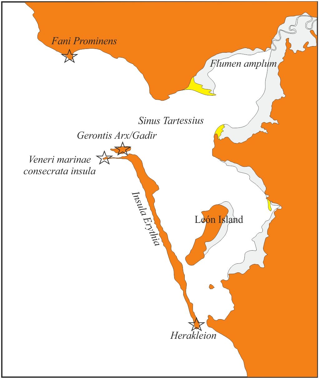
Figure 11 The islands and bay of Cádiz and their vicinity as mentioned in Avienus’ poem Ora Maritima. Geomorphological data partially referred to in Alonso et al. (2015) and Dabrio et al. (2000).
4.4 Identification of Arx Gerontis and Flumen Amplum
As noted earlier, geophysical tests conducted in downtown Cádiz have revealed that an isle lay north and north-west of an outlet of the Bay of Cádiz through to the present-day beach of La Caleta (Figure 11). It is our view that Arx Gerontis stood on this isle located opposite across the bay from Rota and that Arx Gerontis also held the core of the Phoenician settlement referred to in Ora Maritima as “Gadir.” This is the area of the present-day city where the remains of Teatro Cómico were discovered, evidence of a Phoenician settlement destroyed ca. 600 BCE. According to Strabo, in the first millennium BCE this isle housed the ἀντίπολις (antípolis, “city opposite”) of the multi-sited city community of τὰ Γάδϵιρα (Tà Gádeira). The πόλις counterpart sat across the 5-stadium wide outlet of the bay that runs to the beach of La Caleta; that is, on the long island of ‘Eρυθϵία (Erytheía), where Greek mythology places the confrontation between King Geryon and Heracles that saw the former die. Thus, Sinus Tartessius, “the Gulf of Tartessos,” was the Bay of Cádiz as well as the Guadalete paleo-estuary. Flumen amplum was the Guadalete River (Figures 6B, 11).
Finally, the “island consecrated to Venus Marina” was the present-day isle (or peninsula, depending on the tidal cycle) of San Sebastián (Figures 6B, C, 11), where, according to Strabo, a temple for the worship of Kronos once stood. Kronos (the Roman Saturn) and Aphrodite (the Roman Venus) were connected in Greek mythology. Hesiod wrote171 that Kronos was the king of the Titans, who had ruled mankind during its golden age prior to the time of the Gods; he became king after castrating Uranus, the Creator. Aphrodite was born out of the foam that formed about the genitals of Uranus, which Kronos had thrown into the sea.172 From the point of view of Phoenician and Carthaginian mythology, Kronos and Aphrodite were likely the Greek renditions of the overarching god Baal Hammon and his consort, Ashtart or Tanit.173
To conclude, there is no incontrovertible reason to doubt the credibility of Avienus’ Ora Maritima as a historical source for sixth-century BCE Iberia, particularly as concerns the information it offers about the realm of Tartessos in the southernmost third of the peninsula. The dating of Avienus’ composition, some 900 years after the end of contact with this multi-ethnic polity, is no evidence against the poem containing much valuable information from the time when this polity existed. The literary form of the source should also not dissuade analysts from recognizing its documentary value. Neither should Avienus’ admiration for pre-Christian explorers, geographers, ethnologists, and historians, nor the occurrence of ethnic and place names that can be read in no other written source preserved from antiquity.
The first clear indication of the value of the poem is that descriptions therein contained of the geomorphology of the southwestern Spanish littoral differ significantly from those of the same area during the period when Avienus himself paid a visit to Cádiz, in the fourth century CE. For example, by the time of Avienus’ visit, the Guadalquivir Estuary had one outlet instead of two, and Lacus Ligustinus had turned into marshland.
Furthermore, geomorphological reconstruction of the area for the time from ca. 1150 BCE, when EWE C hit the Gulf of Cádiz, into the Roman Imperial Period, is consistent with much of Avienus’ description and aligns with the less detailed information about the same area early in the Roman period conveyed by other authors of antiquity including Pseudo-Scymnus, Strabo, Mela, and Pliny the Elder. Landmarks mentioned in the Ora Maritima that have caused dispute among scholars comprise Palus Erebaea, Hiberus Amnis, Tartessus Amnis, Lacus Ligustinus, Cartare Insula, Tartessus Civitas, Mons Argentarius, Mons Cassius, Fani Prominens, Arx Gerontis, Sinus Tartessius, and Flumen Amplum. We do not think that the exact locations of these landmarks can be exclusively sustained archaeologically and philologically; we present evidence that rests instead upon the results of geomorphological, chronological, and paleo-environmental studies undertaken since the 1970s in the areas of the paleo-estuaries of the Tinto-Odiel, Guadalete, and Guadalquivir rivers. Geophysical and archaeological testing of this conclusion is of course required in turn; though that is beyond the scope of this article, by which we propose a hypothesis so based for the location of Tartessos that justifies such a testing.
Avienus likely relied on at least two rutters from the early sixth century BCE: one for the navigation from the North Atlantic down to the political and trade center of Tartessos and the other for the navigation from this center on to the Phocaean colony of Marseilles. Yet, regardless of the number and form of Avienus’ sources, his poem would appear to contain trustworthy and detailed information about the political, ethnic, and physical geography of the realm of Tartessos. Regaining this information as a historical document significantly contributes to the renewed interest in recent decades in the writings of antiquity that mention this archaic social and political formation of southern Iberia.
Prying into the ground was not such a bad idea, after all. It has made way for due appraisal of Avienus’ testimony.
Data availability statement
The raw data supporting the conclusions of this article will be made available by the authors, without undue reservation.
Author contributions
JV-R: Conceptualization, Data curation, Formal analysis, Funding acquisition, Investigation, Methodology, Project administration, Resources, Software, Supervision, Validation, Visualization, Writing – original draft, Writing – review & editing. AR-R: Conceptualization, Data curation, Formal analysis, Funding acquisition, Investigation, Methodology, Project administration, Resources, Software, Supervision, Validation, Visualization, Writing – original draft, Writing – review & editing. JL-S: Conceptualization, Data curation, Funding acquisition, Investigation, Methodology, Software, Validation, Writing – review & editing. SC-P: Funding acquisition, Investigation, Methodology, Supervision, Validation, Writing – review & editing. ÁL: Funding acquisition, Supervision, Validation, Writing – review & editing.
Funding
The author(s) declare financial support was received for the research, authorship, and/or publication of this article. Funding was provided by Fundación Caja de Madrid (“Proyecto Hinojos: Contrastación de la Hipótesis Wickboldt-Kühne, en Hinojos (Huelva), Fase II”), Fundación Doñana 21 (“Proyecto Hinojos: Fase II"), the town council of Hinojos, Huelva (“Proyecto Hinojos, Fase II”), the Spanish Ministry for Science and Innovation (MICINN) (Research Project of Excellence “Construyendo Tarteso, HAR2015-63788-P”), the Regional Government of Andalusia (support to the RNM-276 Research Group of The University of Huelva, as well as to the Environmental Archaeology Research Group of CSIC-IH for their participation in the Project of Excellence “Relictflora, P11-RNM-7033”), and the FUHEM Foundation (“Proyecto Hinojos”). The article is a contribution to the International Geosciences Programs (IGCPs) of UNESCO nos. 526 (“Risks, Resources, and Record of the Past on the Continental Shelf”), 567 (“Earthquake Archaeology and Paleo-seismology”), and 588 (“Preparing for Coastal Change”).
Conflict of interest
The authors declare that the research was conducted in the absence of any commercial or financial relationships that could be construed as a potential conflict of interest.
Publisher’s note
All claims expressed in this article are solely those of the authors and do not necessarily represent those of their affiliated organizations, or those of the publisher, the editors and the reviewers. Any product that may be evaluated in this article, or claim that may be made by its manufacturer, is not guaranteed or endorsed by the publisher.
Supplementary material
The Supplementary Material for this article can be found online at: https://www.frontiersin.org/articles/10.3389/fmars.2024.1379920/full#supplementary-material
References
Albuquerque P., Ferrer Albelda E. (2019). Restituta Vetere Locorum. As localizaçoes e as apropriaçoes das Cassitérides numa perspectiva historiografica. Helade 5, 202–228. doi: 10.22409/rh.v5i2.42488
Allan J. C. (1970). Considerations on the Antiquity of Mining in the Iberian Peninsula (London: Royal Anthropological Institute of Great Britain and Ireland).
Almagro-Gorbea M. (1982). La ‘colonización’ focense en la Península Ibérica. Estado la cuestión. PP. 204-07, 432–444.
Almagro-Gorbea M. (1996). Ideología y poder en Tartessos y el mundo ibérico (Madrid: Real Academia de la Historia).
Almagro-Gorbea M., Mederos Martín A., Torres Ortiz M. (2017). “La anfictionía tartesia orientalizante,” in Sidereum Ana III. El río Guadiana y Tartessos. Ed. Jiménez Ávila J. (Consorcio Ciudad Monumental Histórico-Artística y Arqueológica de Mérida, Mérida), 15–38.
Alonso C., Gracia F. J., del Río L., Anfuso G., Benavente J., Martínez J. A. (2004). “Registro morfosedimentario de eventos históricos de alta energía en el litoral atlántico del Estrecho de Gibraltar (Trafalgar-Tarifa),” in Contribuciones recientes sobre geomorfología. Eds. Benito G., Díez-Herrero A. (SEG-CSIC, Madrid), 263–271.
Alonso C., Gracia F. J., Rodríguez-Polo S., Martín-Puertas C. M. (2015). El registro de eventos energéticos marinos en la bahía de Cádiz durante épocas históricas. Cuaternario y Geomorfología 29, 95–117. doi: 10.17735/cyg.v29i1-2.29935
Álvarez Martí-Aguilar M. (2005). Tarteso. La construcción de un mito en la historiografía española (Málaga: CEDMA).
Arenas A. (1927). El verdadero Tarteso: refutación del Tarteso del alemán Schulten (Valencia: Manuel Pau).
Arteaga O., Schulz H. D., Roos A.-M. (1995). “El problema del ‘Lacus ligustinus’. Investigaciones geoarqueológicas en torno a las marismas del Bajo Guadalquivir,” in Tartessos 25 años después 1968-1993: Actas del Congreso Conmemorativo del V Symposium Internacional de Prehistoria Peninsular. Ed. BUC, Biblioteca de Urbanismo y Cultura (Ayuntamiento de Jerez de la Frontera, Jerez de la Frontera), 99–133.
Aubet M. E. (Ed.) (1989). Tartessos. Arqueología protohistórica del Bajo Guadalquivir (Sabadell: AUSA).
Aubet M. E. (1994). Tiro y las colonias fenicias de Occidente. Edición ampliada y puesta al día (Barcelona: Crítica).
Aubet M. E. (2001). The Phoenicians and the West: Politics, Colonies and Trade. 2nd edition, trans. Ed. Turton M. (Cambridge: Cambridge University Press).
Aubet M. E. (2009). Tiro y las colonias fenicias de Occidente, Tercera edición actualizada y ampliada (Barcelona: Bellaterra).
Augustinus P. G. E. F. (1989). Cheniers and chenier plains: A general introduction. Mar. Geology 90, 219–229. doi: 10.1016/0025-3227(89)90126-6
Barbadillo-Delgado P. (1951). Alrededor de Tartessos: los descubrimientos de La Algaida (Sanlúcar de Barrameda: Ayuntamiento de Sanlúcar de Barrameda).
Belén M., Escacena J. L. (1992). Las comunidades prerromanas de Andalucía Occidental. Complutum 2-3, 65–87.
Bendala Galán M. (2000). Tartesios, íberos y celtas: pueblos, culturas y colonizadores de la Hispania Antigua (Madrid: Temas de hoy).
Bernal M. (1987). Black Athena: The Afro-asiatic roots of classical civilization. Volume I: The fabrication of Ancient Greece 1785-1985 (New Brunswick: Rutgers University Press).
Bernal-Casasola D., Salomon F., Díaz J. J., Lara M., Rixhon G., Morales J., et al. (2020). Deeper than expected: the finding of a remarkable ancient harbor at Gadir/Gades and an exceptional sedimentary archive (Cádiz, southern Spain). J. Maritime Archaeology 15, 165–183. doi: 10.1007/s11457-020-09258-w
Blanco-Freijeiro A. (1956). Orientalia. Estudio de objetos fenicios y orientalizantes en la Península. ArchEspArq 29, 3–51.
Blanco-Freijeiro A. (1979). Historia de Sevilla: La ciudad antigua (de la prehistoria a los visigodos) (Sevilla: Universidad de Sevilla).
Blanco-Freijeiro A., Corzo-Sánchez R. (1983). Monte Algaida: un santuario púnico en la desembocadura del Guadalquivir. . Historia 16 87, 123–128.
Blanco-González A., Lillios K. T., López-Sáez J. A., Drake B. L. (2018). Cultural, demographic and environmental dynamics of the Copper and Early Bronze Age in Iberia, (3300-1500 BC): Towards an Interregional Multiproxy Comparison at the Time of the 4.2 ky BP Event. J. World Prehistory 31, 1–79. doi: 10.1007/s10963-018-9113-3
Blázquez A. (1909). El periplo de Himilco (siglo VI antes de la Era Cristiana) según el poema de Rufo Festo Avieno titulado “Ora Maritima.” (Madrid: Patronato de Huérfanos de Administración Militar).
Blázquez A. (1923). Avieno, Ora Maritima: edición crítica y estudio geográfico (Madrid: Real Sociedad Geográfica).
Blázquez J. M. (1975). Tartessos y los orígenes de la colonización fenicia en Occidente, 2a edición corregida y ampliada (Salamanca: Universidad de Salamanca).
Bond G., Kromer B., Beer J., Muscheler R., Evans M. N., Showers W., et al. (2001). Persistent solar influence of north Atlantic climate during the Holocene. Science 294, 2130–2136. doi: 10.1126/science.1065680
Bonsor G. E. (1922). El coto de Doña Ana (una visita arqueológica) (Madrid: Tipografía de la Revista de Archivos, Bibliotecas y Museos).
Bonsor G. E. (1928). Tartessos: excavaciones practicadas en 1923 en el Cerro del Trigo, término de Almonte (Huelva) (Madrid: Junta Superior de Excavaciones y Antigüedades).
BUC, Biblioteca de Urbanismo y Cultura, Ayuntamiento de Jerez de la Frontera (1995). Tartessos 25 años después 1968-1993: Actas del Congreso Conmemorativo del V Symposium Internacional de Prehistoria Peninsular (Jerez de la Frontera: Ayuntamiento de Jerez de la Frontera).
Cabrera-Bonet P. (1986). “Los griegos en Huelva: los materiales griegos”, in Homenaje a Luis Siret, (1934-1984). Actas del Congreso “Homenaje a Luis Siret” (1934-1984) (Cuevas de Almanzora, junio 1984)”. Ed. Arteaga O. (Junta de Andalucía, Consejería de Cultura, Dirección General de Bellas Artes, Sevilla), 575–583.
Cabrera-Bonet P. (1988-1989). El comercio foceo en Huelva: cronología y fisionomía. HuelvaArq 10-11, 41–100.
Calderón Felices J., Moreno Ferrero I. (Eds.) (2001). Avieno: Fenómenos, Descripción del Orbe Terrestre, Costas Marinas (Madrid: Gredos).
Campos J. M., Bermejo J., Rodríguez-Vidal J. (2015). La ocupación del litoral onubense en época romana y su relación con eventos marinos de alta energía. Cuaternario y Geomorfología 29, 75–93. doi: 10.17735/cyg.v29i1-2.31570
Caporizzo C., Gracia F. J., Aucelli P. P. C., Barbero L., Martín-Puertas C., Lagóstena L., et al. (2021). Late-Holocene evolution of the Northern Bay of Cádiz from geomorphological, stratigraphic and archaeological data. Quaternary Int. 602, 92–109. doi: 10.1016/j.quaint.2021.03.028
Caro-Baroja J. (1971). “La realeza“ y los reyes en la España antigua. Cuadernos de la Fundación Pastor 17, 53–124.
Caro-Bellido A., Acosta-Martínez P., Escacena J. L. (1987). Informe sobre la prospección arqueológica con sondeo estratigráfico en el solar de la calle Alcazaba (Lebrija, Sevilla). Anuario Arqueológico Andalucía 1986 2, 164–178.
Celestino-Pérez S. (2008). “Tartessos,” in De Iberia a Hispania. Ed. Gracia-Alonso F. (Ariel, Barcelona), 93–345.
Celestino-Pérez S., Cerrillo-Cuenca E., López-Sáez J. A., Pérez-Asensio J. N., Rodríguez-Ramírez A., Villarías-Robles J. J.R., et al (2016b). Razones geológicas, arqueológicas y antropológicas de la conservación de Doñana: el Proyecto Hinojos (2005-2013),” in Doñana: 50 años de investigaciones científicas. Ed. Ferrer M. (CSIC, Madrid), 81–100.
Celestino-Pérez S., López-Ruiz C. (2016a). Tartessos and the Phoenicians in Iberia (Oxford: Oxford University Press).
Cerpa-Niño J. A. (2015). Los fenicios: marco geográfico, costumbres y su expansión colonial (Cádiz: Paraíso Romántico).
Charles-Picard G. and C. (1958). La vie quotidienne à Carthage au temps d’Hannibal, IIIe siècle avant Jésus-Christ (Paris: Hachette).
Cisneros García M. I., Suárez Padilla J., Mayorga J., Escalante Aguilar M. M. (2000). “Cerámicas griegas arcaicas en la Bahía de Málaga,” in Ceràmiques jonies d’època arcaica: centres de producció i comercialització al Mediterrani Occidental: actes de la Taula Rodona celebrada a Empúries, els dies 26 al 28 de maig de 1999. Eds. Cabrera-Bonet P., Santos-Retolaza M. (Museu d’Arqueologia de Catalunya, Empúries, Gerona), 189–205.
Cook S. A. (1930). The Religion of Ancient Palestine in the Light of Archaeology (London: Oxford University Press).
Dabrio C. J., Zazo C., Goy J. L., Sierro F. J., Borja F., Lario L., et al. (2000). Depositional history of estuarine infill during the last postglacial transgression (Gulf of Cadiz, Southern Spain). Mar. Geology 162, 381–404. doi: 10.1016/S0025-3227(99)00069-9
Davies M., Finglass O. J. (Eds.) (2014). Stesichorus: The Poems (Cambridge: Cambridge University Press).
De Hoz J. (1989). “Las fuentes escritas sobre Tartessos,” in Tartessos: arqueología protohistórica del Bajo Guadalquivir. Ed. Aubet M. E. (AUSA, Sabadell), 25–43.
De La Bandera Romero M. L., Ferrer Albelda E. (Eds.) (2010). El Carambolo: 50 años de un tesoro (Sevilla: Universidad de Sevilla).
De San Cecilio P. (1669). Annales de la Orden de Descalzos de Nuestra Señora de la Merced, Redempción de Cautivos Christianos, Parte Primera (Barcelona: Dionisio Hidalgo).
Docter R. F. (1992-1993). Two sherds in a cigarbox: the Greek component in Toscanos-Mainake. Talanta 24-25, 23–41.
Docter R. F. (2000). “East Greek fine wares and transport amphorae of the 8th-5th century BC from carthage and toscanos,” in Ceràmiques jonies d’època arcaica: centres de producció i comercialització al Mediterrani Occidental: actes de la Taula Rodona celebrada a Empúries, els dies 26 al 28 de maig de 1999. Eds. Cabrera-Bonet P., Santos-Retolaza M. (Museu d’Arqueologia de Catalunya, Empúries, Gerona), 63–88.
Domínguez-Monedero A. J. (2013). “Los primeros griegos en la Península Ibérica (s. IX, VI a. C.): mitos, probabilidades, certezas,” in El oriente griego en la Península Ibérica: epigrafía e historia. Eds. de Hoz M. P., Mora G. (Real Academia de la Historia, Madrid), 11–42.
Domínguez-Monedero A. J. (2018). “El ritual funerario de la Tumba del Guerrero de Málaga en el contexto del siglo VI a. C,” in La tumba del guerrero: un enterramiento excepcional en la Málaga fenicia del siglo VI a. C. Eds. García González D., López Chamizo S., García Alfonso E. (Junta de Andalucía, Consejería de Cultura, Sevilla), 395–420.
Du Mesnil du Buisson C. (1963). Origine et évolution du pantheon de Tyr. RHR 164, 133–163. doi: 10.3406/rhr.1963.7927
Escacena J. L., Belén M. (1991). Sobre la cronología del horizonte fundacional de los asentamientos tartésicos. Cuadernos del Suroeste 2, 9–42.
Esteve Guerrero M. (1952). Sanlúcar de Barrameda (Cádiz): fábrica de salazón romana en La Algaida. NAHisp 1, 126–133.
Esteve Guerrero M. (1969). “Asta Regia: Una ciudad tartésica,” in Tartessos: V Symposium Internacional de Prehistoria Peninsular (Jerez 1968). Ed. Maluquer de Motes J. (Universidad de Barcelona, Barcelona), 111–119.
Fernández Amador de los Ríos J. (1925). Atlántida: estudio arqueológico, histórico y geográfico (Zaragoza: Athenaeum).
Fernández-Flores A., Rodríguez-Azogue A. (2007). Tartessos desvelado: la colonización fenicia del suroeste peninsular (Córdoba: Almuzara).
Fernández-Jurado J. (1988-1989). Tartessos y Huelva. Huelva Arqueológica 10-11 (Huelva: Diputación Provincial de Huelva).
Fernández-Jurado J., García-Sanz C., Rufete-Tomico P. (1997). De Tartessos a Onuba: 15 años de arqueología en Huelva (Huelva: Diputación Provincial de Huelva).
Ferrer Albelda E. (Ed.) (2019). La ruta de las Estrímnides. Navegación y conocimiento del litoral Atlántico de Iberia en la Antigüedad (Alcalá de Henares: Universidad de Alcalá and Universidad de Sevilla).
Fletcher W., Boski T., Moura D. (2007). Palynological Evidence for Environmental and Climate Change in the Lower Guadiana Valley (Portugal) during the Last 13,000 years. Holocene 17, 479–492. doi: 10.1177/0959683607077027
Frankenstein S. (1979). “The phoenicians in the far west: A function of neo-asSyrian imperialism,” in Power and Propaganda: A Symposium on Ancient Empire. Ed. Larsen M. T. (Akademisk, Copenhagen), 263–294.
Gangutia E. (1998). ‘Gerioneidas’: desarrollo literario griego en contacto con el Próximo Oriente. Emerita 66, 231–256. doi: 10.3989/emerita.1998.v66.i2.257
Gangutia E. (2008). “Los griegos en España,” in Veinte años de filología griega, (1984-2004). Eds. Rodríguez-Adrados F., Berenguer J. A., Luján E., Rodríguez-Somolinos J. (CSIC, Madrid), 759–790.
García Alfonso E. (2018). “Málaka en los siglos VII-VI a. C.: los orígenes de una ciudad-Estado fenicia occidental,” in La tumba del guerrero: un enterramiento excepcional en la Málaga fenicia del siglo VI a. C. Eds. García González D., López Chamizo S., García Alfonso E. (Junta de Andalucía, Consejería de Cultura, Sevilla), 25–74.
García Alonso J. L. (1996). Nombres griegos en -ουσσα en el Mediterráneo Occidental. Análisis lingüístico e histórico. Complutum 7, 105–124.
García-García F. (2014). Doñana en su historia: cuatro siglos entre la explotación y la conservación bajo la posesión de la Casa de Los Guzmanes (Madrid: Organismo Autónomo Parques Nacionales).
García-Gómez E. (Ed.) (1967). Anales palatinos del califa de Córdoba Al-Hakam II, por `Îsâ Ibn Ahmad Al-Râzî (360-364 H. = 971-975 J. C.) (Madrid: Sociedad de Estudios y Publicaciones).
García González D., López Chamizo S., García Alfonso E. (2018). La tumba del guerrero: un enterramiento excepcional en la Málaga fenicia del siglo VI a. C (Sevilla: Junta de Andalucía, Consejería de Cultura).
García González D., Sánchez Becerra P. (2018). “La arquitectura de la Tumba del Guerrero de Málaga,” in La tumba del guerrero: un enterramiento excepcional en la Málaga fenicia del siglo VI a. C. Eds. García González D., López Chamizo S., García Alfonso E. (Junta de Andalucía, Consejería de Cultura, Sevilla), 111–126.
García y Bellido A. (1944). Tartessós pudo estar donde ahora la isla de Saltés, en el estuario de Huelva. ArchEspArq 17, 191–195.
García y Bellido A. (1947). La España del siglo primero de nuestra era (según P. Mela y C. Plinio) (Madrid: Espasa-Calpe).
García y Bellido ,. A. (1948). Hispania Graeca (Barcelona: Instituto Español de Estudios Mediterráneos).
García y Bellido A. (1993). España y los españoles Hace dos mil años, según la Geografía de Strábon; rev. Ed. García y Bellido M. P. (Madrid: Espasa-Calpe).
Garrido J. P., Orta E. (1975). “El problema de Tartessos: una interpretación arqueológica,” in Huelva: Prehistoria y Antigüedad. Ed. Editora Nacional (Editora Nacional, Madrid), 249–263.
Gavala y Laborde J. (1927). Cádiz y su bahía en el transcurso de los tiempos geológicos. Boletín del Instituto Geológico y Minero España 3a serie 49, 1–29.
Gavala y Laborde J. (1936). Memoria explicativa de la Hoja 1017: El Asperillo, del Mapa Geológico de España, escala 1:50.000 (Madrid: Instituto Geológico y Minero de España).
Gavala y Laborde J. (1959a). La Geología de la Costa y Bahía de Cádiz y el poema “Ora Maritima,“ de Avieno (Madrid: Instituto Geológico y Minero de España).
Gavala y Laborde J. (1959b). “Apéndice: el poema ‘Ora Maritima’ de Rufo Festo Avieno,” in La Geología de la Costa y Bahía de Cádiz y el poema “Ora Maritima,” de Avieno. Ed. Gavala y Laborde J. (Instituto Geológico y Minero de España, Madrid), 1–139 + i-lxxx.
Gener-Basallote J. M., Navarro M. A., Pajuelo J. M., Torres-Ortiz M., López-Rosendo E. (2014). “Arquitectura y urbanismo de la Gadir fenicia: el yacimiento del Teatro Cómico de Cádiz,” in Los fenicios en la Bahía de Cádiz. Nuevas investigaciones. Ed. Botto M. (Fabrizio Serra, Pisa), 14–50.
Godley A. D. (1946-1949). Herodotus in Four Volumes. London: William Heinemann Ltd (Cambridge, Massachusetts: Harvard University Press).
Gómez-Ponce C., Borja F., Lagóstena-Barrios L., López-Amador J. J., Ruiz-Gil J. A., Borja C. (1997). “Primeras fases de la evolución de la flecha litoral de Valdelagrana (El Puerto de Santa María, Cádiz): datos arqueológicos,” in Cuaternario ibérico. Ed. Rodríguez-Vidal J. (Universidad de Huelva, Huelva), 165–167.
González de Canales F. (2014). Tarshish-Tartessos, the Emporion Reached by Kolaios of Samos. Cahiers de l’Institut du Proche-Orient Ancien du Collège de France 2, 559–576.
González de Canales F., Domínguez-Monedero A. J., Llompart J., Montaño A. (2018). Un grupo nuevo de cerámica griega (Grupo H) fabricado en Tartessos (Huelva, España). Cuadernos de Prehistoria y Arqueología 44, 133–143. doi: 10.15366/cupauam2018.44.007
González de Canales F., Llompart J. (2017). Producción de cerámicas griegas arcaicas en Huelva. ArchEspArq 90, 125–145. doi: 10.3989/aespa.090.017.006
González de Canales F., Serrano L., Llompart J. (2004). El emporio fenicio precolonial de Huelva (ca. 900-770 a. C.) (Madrid: Biblioteca Nueva).
González-Wagner C., Alvar J. (1989). Fenicios en Occidente: la colonización agrícola. RStFen 17, 61–102.
Gracia F. J., Alonso C., Gallardo M., Giles F., Benavente J., López-Aguayo F. (1999). Evolución eustática postflandriense en las marismas del Sur de la Bahía de Cádiz. Geogaceta 27, 71–74.
Gran-Aymerich J. M. J. (1988). Cerámicas griegas y etruscas de Málaga. Excavaciones de 1980 a 1986. ArchEspArq 61, 201–222.
Harrison R. J. (1988). Spain at the Dawn of History: Iberians, Phoenicians and Greeks (London: Thames and Hudson).
Hinz M., Schirmacher J., Kneisel J., Rinne C., Weinelt M. (2019). The Chalcolithic-Bronze Age Transition in Southern Iberia under the Influence of the 4.2 ka BP event? A Correlation of Climatological and Demographic proxies. J. Neolithic Archaeology 21, 1–26. doi: 10.12766/jna.2019.1
Hunt Ortiz M. A. (2009). “La explotación de los recursos minerales en las Minas de Aznalcóllar: una visión diacrónica a través del registro arqueológico,” in Paper presented at I Encuentro de Arqueología del Guadiamar, Olivares (Sevilla), 19-23 October 2009. Unpublished document.
Hunt Ortiz M. A. (2015). “Metalurgia prehistórica en el entorno de Doñana,” Paper presented at Arqueodoñana: Seminario en la Universidad de Sevilla sobre explotación económica y cultural del patrimonio arqueológico como parte de los ecosistemas naturales, Seville, 5-6 November 2015. Unpublished document.
Hunt Ortiz M. A. (1995). “El foco metalúrgico de Aznalcóllar, Sevilla. Técnicas analíticas aplicadas a la arqueometalurgia del Suroeste de la Península Ibérica,” Ed. BUC, Biblioteca de Urbanismo y Cultura del Ayuntamiento de Jerez de La Frontera, Tartessos 25 años después, 1968-1993: Actas del Congreso Conmemorativo del V Symposium Internacional de Prehistoria Peninsular (BUC, Biblioteca de Urbanismo y Cultura del Ayuntamiento de Jerez de La Frontera, Jerez de La Frontera), 447–473.
Jackson N. L. (2013). “Estuaries,” in Treatise on Geomorphology, vol. 10 . Ed. Shroder J. F. (Elsevier, Amsterdam), 308–327.
Jacob P. (1985). Notes sur la toponymie grecque de la côte méditerranéenne de l’Espagne antique. Ktema 10, 247–271. doi: 10.3406/ktema.1985.1968
Jalut G., Dedoubat J. J., Fontugne M., Otto T. (2009). Holocene circum-mediterranean vegetation changes: climate forcing and human impact. Quaternary Int. 200, 4–18. doi: 10.1016/j.quaint.2008.03.012
Jiménez-Moreno G., Rodríguez-Ramírez A., Pérez-Asensio J. N., Carrión J. S., López-Sáez J. A., Villarías-Robles J. J. R., et al. (2015). Impact of Late-Holocene aridification trend, climate variability and geodynamic control on the environment from a coastal area in SW Spain. Holocene 25, 607–617. doi: 10.1177/0959683614565955
Koch M. (2003). Taršiš e Hispania: estudios histórico-geográficos y etimológicos sobre la colonización fenicia de la Península Ibérica (Trans. M. Prieto-Vilas. Madrid: Centro de Estudios Fenicios y Púnicos).
Lamboglia N. (1974). “Encore sur la fondation d’Ampurias,” in Simposio Internacional de Colonizaciones (Barcelona-Ampurias 1971). Eds. Ripoll Perelló E., Sanmartì Grego E. (Diputación Provincial de Barcelona, Barcelona), 105–108.
Lario J., Zazo C., Goy J. L., Silva P. G., Bardají T., Cabero A., et al. (2011). Holocene palaeotsunami catalogue of SW Iberia. Quaternary Int. 242, 196–200. doi: 10.1016/j.quaint.2011.01.036
Laserre F. (Ed.) (1966). Strabon: Géographie, Tome II (Livres III et IV) (Paris: Société d’édition “Les Belles Lettres.”).
Lillios K. T., Blanco-González A., Drake B. L., López-Sáez J. A. (2016). Mid-Late Holocene climate, demography, and cultural dynamics in Iberia: A multi-proxy approach. Quaternary Sci. Rev. 135, 138–153. doi: 10.1016/j.quascirev.2016.01.011
López-Amador J. J., Ruiz-Gil J. A. (2010). “Las ofrendas del santuario púnico gaditano de La Algaida (Sanlúcar de Barrameda),” in Cuaternario y arqueología: homenaje a Francisco Giles Pacheco. Ed. Mata Almonte E. (Diputación Provincial de Cádiz, Cádiz), 271–281.
López-Castro J. L. (1992). “Pompeyo Trogo (Justino XLIV, 5, 1-4) y el imperialismo cartaginés en la Península Ibérica,” in Universidad de Granada. Ed. Cabrera Moreno J. (Universidad de Granada, Granada), 219–235.
López-Sáez J. A., López-García P., Martín-Sánchez M. (2001). Análisis palinológico del yacimiento arqueológico de Pocito Chico (El Puerto de Santa María): el paisaje prehistórico y protohistórico durante el Holoceno reciente en las Marismas de Cádiz. Cuaternario y Geomorfología 15, 45–59.
López-Sáez J. A., López-García P., Martín-Sánchez M. (2002). Palaeoecology and Holocene environmental change from a saline lake in south-west Spain: the protohistorical and prehistorical vegetation in Cádiz bay. Quaternary Int. 93-94, 197–206. doi: 10.1016/S1040-6182%2802%2900018-6
López-Sáez J. A., Pérez-Díaz S., Rodríguez-Ramírez A., Blanco-González A., Villarías-Robles J. R., Luelmo-Lautenschlaeger R., et al. (2018). Mid-Late Holocene environmental and cultural dynamics at the south-west tip of europe (Doñana national Park, SW Iberia, Spain). J. Archaeological Science: Rep. 22, 58–78. doi: 10.1016/j.jasrep.2018.09.014
Magny M. (1993). Solar influences on Holocene climatic changes illustrated by correlations between past lake-level fluctuations and the atmospheric 14C record. Quaternary Res. 40, 1–9. doi: 10.1006/qres.1993.1050
Magny M. (2004). Holocene climate variability as reflected by mid-european lake-level fluctuations and its probable impact on prehistoric human settlements. Quaternary Int. 113, 65–79. doi: 10.1016/S1040-6182(03)00080-6
Mangas J., Plácido D. (1994b). “Introducción,” in Testimonia Hispaniae Antiqua [THA] I. Avieno. Eds. Mangas J., Plácido D. (Historia 2000, Madrid), 11–30.
Mangas J., Plácido D. (Eds.) (1998). Testimonia Hispaniae Antiqua [THA] IIa. La península ibérica en los autores griegos: de Homero a Platón (Madrid: Fundación de Estudios Romanos).
Marcotte D. (2000). “Notice,” in Géographes grecs, Tome I. Ed. Marcotte D. (Société d’édition “Les Belles Lettres”, Paris), 1–100.
Martín de la Cruz J. C. (1984-1985). Problemas en torno a la definición del Bronce Tardío en la Baja Andalucía. Cuadernos de Prehistoria y Arqueología 11-12, 205–215.
Martín de la Torre A. (1940). Tartessos (geografía histórica del SO de España) (Sevilla: José Zambrano).
Martínez-Sánchez A., Gracia F. J., Alonso C., Mata E., Caporizzo C. (2023). Reconstructing the historical evolution of the Northern Bay of Cádiz (SW Spain) from geomorphological and geoarchaeological data. J. Maps 19, 2206585. doi: 10.1080/17445647.2023.2206585
Martín Ruiz J. A., García Carretero J. R. (2018). Greek armament from the south of the Iberian Peninsula during the 1st millennium BC. Athens J. History 4, 279–294. doi: 10.30958/ajhis.4-4-2
Maurenbrecher B. (Ed.) (1893). C. Sallusti Crispi Historiarum reliquiae, Fasciculus II (Leipzig: Teubner).
Mazzarino S. (1947). Fra Oriente e Occidente; ricerche di storia greca arcaica (Firenze: La Nuova Italia).
Mederos Martín A. (2001). Fenicios evanescentes. Nacimiento, muerte y redescubrimiento de los fenicios en la Península Ibérica. I., (1780-1935). Saguntum 33, 37–48. doi: 10.7203/SAGVNTVM
Mederos Martín A. (2004). Fenicios evanescentes. Nacimiento, muerte y redescubrimiento de los fenicios en la Península Ibérica. II., (1780-1935). Saguntum 36, 35–46. doi: 10.7203/SAGVNTVM.36.1725
Mederos Martín A. (2006). Fenicios en Huelva, en el siglo X a. C., durante el reinado de Hîrãm I de Tiro. Spal 15, 167–188. doi: 10.12795/spal.2006.i15.08
Medialdea T., Somoza L., Pinheiro L. M., Fernández-Puga M. C., Vázquez J. T., León R., et al. (2009). Tectonics and mud volcano development in the gulf of Cádiz. Mar. Geology 261, 48–63. doi: 10.1016/j.margeo.2008.10.007
Menanteau L. (1981). Les marismas du Guadalquivir. Exemple de transformation d’un paysage alluvial au cours du Quaternaire récent. Université de Paris-Sorbonne, Paris.
Morales J. A., Borrego J., San Miguel E. G., López-González N., Carro B. (2008). Sedimentary record of recent tsunamis in the Huelva Estuary (Southwestern Spain). Quaternary Sci. Rev. 27, 734–746. doi: 10.1016/j.quascirev.2007.12.002
Morales J. A., Borrego J., Davis R. A. (2014). A new mechanism for chenier development and a facies model of the Saltés island chenier plain (SW Spain). Geomorphology 204, 265–276. doi: 10.1016/j.geomorph.2013.08.011
Morel J.-P. (1975). L’expansion phocéenne en Occident: dix années de recherches, (1966-1975). BCH. 99, 853–896. doi: 10.3406/bch.1975.4836
Morel J.-P. (1984). “Greek colonization in Italy and in the west: problems of evidence and interpretation,” in Crossroads of the Mediterranean: Papers Delivered at the International Conference on the Archaeology of Early Italy (Haffenreffer Museum, Brown University, May 8-10, 1981). Eds. Hackens T., Holloway N. D., Holloway R.R. (Brown University Center for Old World Archaeology and Art, Providence, R.I., USA, and Institut Supérieur d'Archéologie et d'Histoire de l'Art, Collège Erasme, Louvain-la-Neuve, Belgique), 123–161.
Morel J.-P. (1997). “Problématique de la colonization grecque en Méditerranée occidentale: l’exemple des résaux,” in Il dinamismo della colonizzazione greca. Atti della tavola rotonda “Espansione e colonizzazione greca d’età arcaica: metodologie e problemi a confronto (Venezia, 10-11/11/1995). Ed. Antonetti C. (Loffredo, Napoli), 59–70.
Morel J.-P. (2000). “Céramiques ioniennes et commerce phocéen en Occident: avancées et problems,” in Ceràmiques jonies d’època arcaica: centres de producció i comercialització al Mediterrani Occidental: actes de la Taula Rodona celebrada a Empúries, els dies 26 al 28 de maig de 1999. Eds. Cabrera-Bonet P., Santos-Retolaza M. (Museu d’Arqueologia de Catalunya, Empúries, Gerona), 11–25.
Müller C., Dübner F. (Eds.) (1853-1858). Strabonis Geographica. Graece cum versione reficta (Paris: Didot).
Niemeyer H. G. (1979-1980). A la búsqueda de Mainake: el conflicto entre los testimonios arqueológicos y escritos. Trans. R. von der Golta. Habis 10-11, 279–302.
Olmos R. (1982). La cerámica griega en el sur de la Península Ibérica: la aportación de Huelva. PP. 37, 393–406.
Pappa E. (2013). Early Iron Age Exchange in the West: Phoenicians in the Mediterranean and the Atlantic (Leuven, Paris, and Walpole, MA, USA: Peeters).
Pellicer M. (2010). El anforoide oriental de Coria del Río (Sevilla). Temas Estética y Arte 24, 17–38.
Pemán C. (1941). El pasaje tartésico de Avieno a la luz de las últimas investigaciones (Madrid: CSIC).
Pendón J. G., Morales J. A., Borrego J., Jiménez I., López M. (1998). Evolution and facies architecture in a tidal channel environment along the mesotidal coast of Huelva, SW Spain: evidence for a change from tide to wave domination. Mar. Geology 147, 43–62. doi: 10.1016/S0025-3227(98)00006-1
Peretti A. (1979). Il periplo di Scilace: Studio sul primo portolano del Mediterraneo (Pisa: Giardini).
Polanyi K. (1957). “The economy as instituted process,” in Trade and Market in the Early Empires: Economies in History and Theory. Eds. Polanyi K., Arensberg C. M., Pearson H. W. (Henry Regnery, Chicago), 243–270.
Quesada-Sanz F., García-González D. (2018). “Las armas de la Tumba del Guerrero de Málaga,” in La tumba del guerrero: un enterramiento excepcional en la Málaga fenicia del siglo VI a. C.”. Eds. García González D., López Chamizo S., García Alfonso E. (Junta de Andalucía, Consejería de Cultura, Sevilla), 145–230.
Recio Ruiz A. (1990). La cerámica fenicio-púnica, griega y etrusca del sondeo de San Agustín (Málaga) (Málaga: Diputación Provincial de Málaga).
Rodríguez-González E. (2020). Tarteso y lo orientalizante: una version historiográfica de una confusión terminológica y su aplicación a la cuenca media del Guadiana. Lucentum 39, 113–129. doi: 10.14198/LVCENTVM2020.39.06
Rodríguez-González E. (2022). El final de Tarteso. Arqueología Protohistórica del Valle Medio del Guadiana (Mérida: Consorcio de la Ciudad Monumental de Mérida).
Rodríguez-Ramírez A. (1998). Geomorfología del Parque Nacional de Doñana y su entorno (Madrid: Ministerio de Medio Ambiente, Organismo Autónomo Parques Nacionales).
Rodríguez-Ramírez A., Flores-Hurtado E., Contreras C., Villarías-Robles J. J. R., Jiménez-Moreno G., Pérez-Asensio J. N., et al. (2014). The role of neo-tectonics in the sedimentary infilling and geomorphological evolution of the Guadalquivir estuary (Gulf of Cadiz, SW Spain) during the Holocene. Geomorphology 219, 126–140. doi: 10.1016/j.geomorph.2014.05.004
Rodríguez-Ramírez A., Gracia F. J., Morales J. A., García D., Mayoral E. (2024). A Late Pleistocene coastal plain pertaining to MIS 5 in the Gulf of Cádiz (mouth of the Guadalquivir River, SW Iberia). Geomorphology 452, 109096. doi: 10.1016/j.geomorph.2024.109096
Rodríguez-Ramírez A., Pérez-Asensio J. N., Santos A., Jiménez-Moreno G., Villarías-Robles J. J. R., Mayoral E., et al. (2015). Atlantic extreme wave events during the last four millennia BP in the Guadalquivir Estuary, SW Spain. Quaternary Res. 83, 24–40. doi: 10.1016/j.yqres.2014.08.005
Rodríguez-Ramírez A., Pérez-Asensio J. N., Villarías-Robles J. J. R. (2023). Geomorphological and morpho-sedimentary features of a sand barrier in a tectonically asymmetrical estuary during the late holocene: La Algaida (SW Spain). Geomorphology 432, 108711. doi: 10.1016/j.geomorph.2023.108711
Rodríguez-Ramírez A., Ruiz A., Cáceres L., Rodríguez-Vidal J., Pino R., Muñoz J. M. (2003). Analysis of the recent storm record in the southwestern Spanish coast: implications for littoral management. Sci. Total Environ. 303, 189–201. doi: 10.1016/S0048-9697(02)00400-X
Rodríguez-Ramírez A., Villarías-Robles J. J. R., Celestino-Pérez S., López-Sáez J. A., Pérez-Asensio J. N., León A., et al. (2022). “Extreme-Wave Events in the Guadalquivir Estuary in the Late Holocene: Paleogeographical and cultural implications,” in Historical Earthquakes, Tsunamis and Archaeology in the Iberian Peninsula. Eds. Álvarez Martí-Aguilar M., Machuca Prieto F. (Springer Nature, Singapore), 127–150. doi: 10.1007/978-981-19-1979-4
Rodríguez-Ramírez A., Villarías-Robles J. J. R., Pérez-Asensio J. N., Celestino-Pérez S. (2019). “The guadalquivir estuary: spits and marshes,” in The Spanish Coastal Systems. Ed. Morales J. A. (Springer, Cham, Switzerland), 517–541.
Rodríguez-Ramírez A., Villarías-Robles J. J. R., Pérez-Asensio J. N., Santos A., Morales J. A., Celestino-Pérez S., et al. (2016). Geomorphological record of extreme wave events during roman times in the Guadalquivir estuary (Gulf of Cadiz, SW Spain): an archaeological and paleogeographical approach. Geomorphology 261, 103–118. doi: 10.1016/j.geomorph.2016.02.030
Rodríguez-Ramírez A., Yáñez C. M. (2008). Formation of chenier plain of the Doñana marshland (SW Spain): observations and geomorphic model. Mar. Geology 254, 187–196. doi: 10.1016/J.MARGEO.2008.06.006
Rodríguez-Somolinos H. (1998). “Inscriptiones graecae antiquissimae iberiae (IGAI),” in Testimonia Hispaniae Antiqua [THA] IIa. La península ibérica en los autores griegos: de Homero a Platón. Eds. Mangas J., Plácido D. (Fundación de Estudios Romanos, Madrid), 333–362.
Rodríguez-Vidal J. (1987). Modelo de evolución geomorfológica de la flecha litoral de Punta Umbría (Huelva, España). Cuaternario y Geomorfología 1, 247–256.
Röllig W. (1982). “Die Phönizier des Mutterlandes zur Zeit der Kolonisierung,” in Phönizier im Westen. Die Beiträge des Internationalen Symposiums über ‘Die phönizische Expansion im westlichen Mittelmeerraum’ in Köln vom 24. bis 27. April 1979. Ed. Niemeyer H. G. (Zabern, Mainz am Rhein), 15–30.
Rouillard P. (1991). Les grecs et la Péninsule Ibérique du VIIIe au IVe siècle avant Jésus-Christ (Paris: De Boccard).
Ruiz-Mata D. (2016). Las ciudades fenicias del Castillo de Doña Blanca y Cádiz durante el siglo VIII a. C. Mi visión actual según los datos recientes arqueológicos. RStFen 44, 305–318.
Ruiz Mata D. (2022). La ciudad fenicia del Castillo de Doña Blanca (El Puerto de Santa María, Cádiz). Resultados de un Proyecto de Investigación (1979-2003). Cuadernos de Prehistoria y Arqueología 48, 141–227. doi: 10.15366/cupauam2022.48.1.005
Ruiz-Mata D. (2023). Tartesos y tartesios. Visión historiográfica y arqueológica (Córdoba: Almuzara).
Ruiz-Mata D., Pérez C. J. (1995). El poblado fenicio del Castillo de Doña Blanca (El Puerto de Santa María, Cádiz) (El Puerto de Santa María: Ayuntamiento del Puerto de Santa María).
Salkield L. U. (1970). “Ancient slags in the South West of the Iberian Peninsula,” in La minería hispana e iberoamericana: contribución a su investigación histórica. Estudios, Fuentes, Bibliografía. VI Congreso Internacional de Minería (Madrid 1970). Eds. Maffei E., Figueroa R.R. (Cátedra de San Isidoro, León), 85–98.
Sanmartì-Grego E. (1992a). “Massalia et Emporion: une origine commune, deux destins différents,” in Marseille grecque et la Gaule, Actes du Colloque international d’Histoire et d’Archéologie et du Ve Congrès archéologique de Gaule méridionale (Marseille, 18-23 Novembre 1990). Eds. Bats M., Bertucchi G., Conges G., Treziny H. (A.D.A.M Éditions and Université de Provence, Lattes and Aix-en-Provence), 27–41.
Sanmartì-Grego E. (1992b). “Nuevos datos sobre Emporion,” in Griegos en Occidente. Ed. Chaves-Tristán F. (Universidad de Sevilla, Sevilla), 173–194.
Savory H. N. (1968). Spain and Portugal: the Prehistory of the Iberian Peninsula (London: Thames and Hudson).
Schulten A. (Ed.) (1925). Fontes Hispaniae Antiquae II: 500 a. de J. C. hasta César (Barcelona: Bosch).
Schulten A. (Ed.) (1935). Fontes Hispaniae Antiquae III: las guerras de 237-154 antes de J. C (Barcelona: Bosch).
Schulten A. (Ed.) (1955a). Fontes Hispaniae Antiquae I: Avieno, Ora Maritima (Periplo Masaliota del siglo VI a. de J. C.) junto con los demás testimonios anteriores al año 500 a. de J. C. 2nd ed (Barcelona: Bosch).
Schulten A. (1955b). “El periplo marsellés,” in Fontes Hispaniae Antiquae I: Avieno, Ora Maritima (periplo masaliota del siglo VI a. de J. C.) junto con los demás testimonios anteriores al año 500 a. de J. C, 2nd ed. Ed. Schulten A. (Barcelona: Bosch), 11–63.
Shefton B. B. (1982). “Greeks and Greek imports in the south of the iberian peninsula. The archaeological evidence,” in Phönizier im Westen. Die Beiträge des Internationalen Symposiums über ‘Die phönizische Expansion im westlichen Mittelmeerraum’ in Köln vom 24. bis 27. April 1979. Ed. Niemeyer H. G. (Zabern, Mainz am Rhein), 337–368.
Shipley G. (2011). “Introduction,” in Pseudo-Skylax’s Periplous: The Circumnavigation of the Inhabited World. Ed. Shipley G. (Bristol Phoenix Press, Exeter), 1–23.
Sociedad Geográfica de Madrid. (1878). Antigüedades de andalucía. Boletín la Sociedad Geográfica Madrid 5, 13–14.
Spanish Ministry of Fomento (2005). Información climática de nivel del mar. Mareógrafo de Sevilla (Bonanza) (Madrid: Ministerio de Fomento).
Stevenson A. C., Moore P. D. (1988). Studies in the vegetational history of S. W. Spain. IV. Palynological investigations of a valley mire at el Acebrón, Huelva. J. Biogeography 15, 339–361. doi: 10.2307/2845417
Täckholm U. (1969). “El concepto de Tarschisch en el Antiguo Testamento y sus problemas,” in Tartessos: V Symposium Internacional de Prehistoria Peninsular (Jerez 1968). Ed. Maluquer de Motes J. (Universidad de Barcelona, Barcelona), 79–90.
Tarradell M. (1969). “El problema de Tartessos visto desde el lado meridional del Estrecho de Gibraltar,” in Tartessos: V Symposium Internacional de Prehistoria Peninsular (Jerez 1968). Ed. Maluquer de Motes J. (Universidad de Barcelona, Barcelona), 221–232.
Tejera-Gaspar A. (1985). Excavaciones arqueológicas en el Huerto Pimentel (Lebrija, Sevilla). NAHisp 26, 88–116.
Tiemblo A. (1994). Un nuevo casco griego de bronce posiblemente hallado en España. Rev. Arqueología 158, 32–35.
Valencia Rodríguez R. (1988). Sevilla musulmana hasta la caída del Califato: contribución a su estudio. Universidad Complutense de Madrid, Madrid.
Vallet G., Villard F. (1966). Les Phocéens en Méditerranée occidental à l’époque archaïque et la foundation de Hyélè. PP. 21, 166–190.
Vigil M. (1973). “Edad Antigua,” in Condicionamientos geográficos. Edad antigua. Eds. Cabo A., Vigil M. (Alfaguara, Madrid), 185–468.
Villalba i Varneda P. (Ed.) (1986a). Ruf Fest Aviè, Periple [Ora Maritima]. Introducció, text, traducció i notes (Barcelona: Fundació Bernat Metge).
Villalba i Varneda P. (1986b). “Introducció,” in Ruf Fest Aviè, Periple [Ora Maritima]. Introducció, text, traducció i notes. Ed. Villalba i Varneda P. (Barcelona: Fundació Bernat Metge), 9–67.
Villard F. (1960). La céramique grecque de Marseille (VIe-IVe siècle): essai d’histoire économique (Paris: De Boccard).
Villarías-Robles J. J. R., Rodríguez-Ramírez A. (2017). “The representation of the kingdom of Tartessus by the ancient Greeks revisited: New evidence for a forgotten cause,” in Ancient Greece and Contemporary World: The Influence of Greek Thought on Philosophy, Science and Technology. An International Conference (Ancient Olympia, 28-31 August 2016). Ed. Paipetis S. A. (University of Patras & International Center for Sciences and Hellenic Values, Athens), 133–141.
Villarías-Robles J. J. R., Rodríguez-Ramírez A. (2019). “The representation of the kingdom of Tartessus by the ancient Greeks revisited: New evidence for a forgotten cause,” in The Influence of Hellenic Philosophy on the Contemporary World. Eds. Dellis J. G., Paipetis S. A. (Cambridge Scholars Publishing, Newcastle upon Tyne, UK), 204–216.
Walker M. J. C., Berkelhammer M., Björck S., Cwynar L. C., Fisher D. A., Long A. J., et al. (2012). Formal subdivision of the holocene series/epoch: A discussion paper by a working group of INTIMATE (Integration of ice-core, marine and terrestrial records) and the sub-commission on Quaternary stratigraphy (International commission on stratigraphy). J. Quaternary Sci. 27, 649–659. doi: 10.1002/jqs.2565
Whittaker C. R. (1974). The Western Phoenicians: Colonization and assimilation. Proc. Cambridge Philological Soc. 200, 58–79. doi: 10.1017/S0068673500001486
Yll R., Zazo C., Goy J. L., Pérez R., Pantaleón J., Civis J., et al. (2003). “Quaternary paleoenvironmental changes in South Spain,” in Quaternary Climatic Changes and Environmental Crises in the Mediterranean Region. Eds. Ruiz-Zapata B., Dorado M., Valdeolmillos A., Gil M. J., Bardají T., Bustamante I., et al (Universidad de Alcalá-INQUA, Alcalá de Henares), 201–213.
Zazo C., Dabrio C. J., Goy J. L., Lario J., Cabero A., Silva P. G., et al. (2008). The Coastal Archives of the Last 15 ka in the Atlantic–Mediterranean Spanish Linkage Area: Sea level and Climatic changes. Quaternary Int. 181, 72–87. doi: 10.1016/j.quaint.2007.05.021
Zazo C., Goy J. L., Somoza L., Dabrio C. J., Belluomini G., Improta S., et al. (1994). Holocene sequence of sea-level fluctuations in relation to climatic trends in the Atlantic-Mediterranean linkage coast. J. Coast. Res. 10, 933–945.
Endnotes
1A preliminary, shorter version of this article was presented in the International Conference Ancient Greece and the Modern World (Olympia, Greece, August 28-31, 2016 ) with the title “The Representation of the Kingdom of Tartessus by the Ancient Greeks Revisited: New Evidence for a Forgotten Cause” (Villarías-Robles and Rodríguez-Ramírez, 2017); two years later, such a contribution was selected for a book published in the United Kingdom (Villarías-Robles and Rodríguez-Ramírez, 2019). Like that shorter version, the present article is a product of the Hinojos Project, a multidisciplinary investigation into the hypothetical cause-and-effect relationship between geomorphological transformations and cultural developments in Southwest Spain during the Middle and Late Holocene, from the Neolithic period through to the Roman Imperial Period. We appreciate the support and encouragement of S. Papamarinopoulos, of the University of Patras, Jennifer Sacher, of the American School of Classical Studies at Athens, J. A. Berenguer and J. and H. Rodríguez-Somolinos, of CSIC, M. Naranjo, Mayor of Hinojos, J. C. Rubio, Director of Espacio Natural de Doñana (END), R. Fernández-Baca, Director of Instituto Andaluz del Patrimonio Histórico (IAPH), and the personnel of the END administration, Estación Biológica de Doñana (EBD), Delegación de Cultura of Junta de Andalucía in Huelva, and Organismo Autónomo Parques Nacionales (OAPN) of the Spanish Ministry for The Environmental Transition and The Demographic Challenge (MITECO). In addition, we appreciate the comments to our reading of Avienus’ Ora Maritima by M. Conde-Salazar, of CSIC, and the comments to our understanding of the relevant excerpts of Pseudo-Scymnus’ and Strabo’s works by I. Pajón-Leyra, also of CSIC. We thank Micaela Pattison, of The University of Sydney, Jane B. Carter, of Tulane University, and other, anonymous, reviewers of other academic institutions for their thorough, insightful revisions of drafts of the manuscript. Responsibility for the form and contents of the article can only rest with us exclusively, however.
2Bernal, 1987, pp. 281-336, 400-427. See also Vella, 1996 and Mederos Martín, 2001, 2004. Vella’s title “Elusive Phoenicians” (Vella, 1996) and Mederos Martín’s “Fenicios evanescentes” (Mederos Martín, 2001, 2004) might mislead some readers. Vella duly remarked on the new turn in Phoenician and Punic Studies that had started in the 1960s, in Iberia and elsewhere in the Mediterranean. As a measure of the magnitude attained by the discipline, he called attention to the Fourth International Conference of Phoenician and Punic Studies convened in Cádiz in October 1995, which “attracted about 200 papers and 600 participants” (Vella, 1996, pp. 245, 248). Mederos Martín discussed the extension and impact of archaeological excavations at Phoenician sites in northern Morocco from the late 1940s and in southern Spain from the early 1960s, which led to a “redescubrimiento” of the Phoenicians in Spain after the Jerez symposium (Mederos Martín, 2001, p. 37; Mederos Martín, 2004, pp. 38-43).
3Mangas and Plácido, 1994b, pp. 17-18, 26.
4In Gavala y Laborde, 1959b, pp. i-lxxx.
5Peretti, 1979, pp. 13-17; Villalba i Varneda, 1986, pp. 33-42.
6Island Sacra was peopled by the “gens Hiernorum,” reads Ora Maritima (hereafter “Or. Mar.”) verses 110-111. Blázquez (1909, pp. 33-37; Blázquez, 1923, pp. 88-89) placed this island somewhere off southwest Iberia, as he assumed that late-sixth or early fifth-century BCE Carthaginian navigator Himilco, for Blázquez the primary source for Ora Maritima, failed to sail beyond Cape Sâo Vicente (Figure 1). In contrast, Schulten (1955a, p. 95) inferred from the genitive Hiernorum to the name “Hierne” which he understood to mean Ireland. Gavala y Laborde (1959b, pp. 68-69) agreed with this identification and so did many other scholars, including Berthelot (1934, p. 58), Villalba i Varneda (1986a, p. 77), J. Alvar (in Mangas and Plácido, 1994a, p. 55), and Calderón Felices (in Calderón Felices and Moreno Ferrero, 2001, p. 309). However, Pliny the Elder in his Naturalis Historia (hereafter “N. H.”), 4.111, first century CE, listed the albiones as one of the peoples inhabiting the northern coasts of present-day Asturias and Galicia, in northwest Spain. Verses 108-112 of Or. Mar. inform that Insula Albionum was near (“propinqua”) Insula Sacra.
7Or. Mar. verses 178-182.
8Arenas, 1927, pp. 270-305; Berthelot, 1934, pp. 19, 55, 79; Schmitt, 1978; González Ponce, 1995; Marcotte, 2000, pp. 92-93.
9Schulten, 1955b, p. 56.
10Peretti, 1979, pp. 23-29; Niemeyer, 1979-1980, p. 290; Jacob, 1985, p. 271; Villalba i Varneda, 1986b, pp. 28-30, 48-49; Domínguez-Monedero, 1996, p. 49; Calderón Felices and Moreno Ferrero, 2001, pp. 290-291; Domínguez-Monedero, 2013, p. 19.
11Verses 42-50.
12Strabo’s Tὰ γϵωγραφικά (Tà Geographiká, Geographical Treatise) (hereafter, “Str.”), 3.4.8.
13In modern scholarship: Sanmartì-Grego, 1992a, b; Boardman, 1999, p. 218; Domínguez-Monedero, 2013, p. 33. However, Lamboglia (1949, 1974) and Hind (1972) argued that the Ora Maritima does include a reference to Emporion, though under a different name: Cypsela in verse 527 (Lamboglia, 1949, 1974) or Pyrene in verse 559 (Hind, 1972). Both scholars relied on a debatable interpretation of the relevant part of the Ora Maritima which is beyond the scope of this article to discuss. Suffice it to caution that Cypsela has been hypothetically placed at the archaeological site of Ullastret, some 10 km from the coast in the province of Girona, and Pyrene by Cape Creus, near the French border (Arribas, 1976, p. 66). Lamboglia accepted (Lamboglia, 1949, p. 158) that Avienus’ source, or sources, could date from the early sixth century BCE, notwithstanding his argument about the location of the city of Cypsela.
14Or. Mar. 94-116.
15Two days of navigation to Insula Sacra (Or. Mar. 108-109). The Insulae Oestrymnides spread out across a gulf by or past Cape Oestrymnis (Or. Mar. 94) sailing from the south. In 1870 K. Müllenhoff (in Schulten, 1955b, p. 58) placed this cape in westernmost Brittany, an interpretation that Schulten himself (Schulten, 1955a, p. 93) and other commentators accepted, including Berthelot (1934, p. 57), Gavala y Laborde (1959b, p. 67), and Alvar (in Mangas and Plácido, 1994, p. 55). Off westernmost Brittany is the isle, erstwhile cape, of Ouessant (Schulten, 1955a, p. 93). Strabo mentioned (1.4.5; 4.4.1) for present-day Brittany a cape Kάβαιον (Kábaion) in the territory of the Ὠστιμίοι (Ôstimíoi), possibly Ouessant; his sources were at least Pytheas of Massalia, who had explored the North Atlantic in the mid fourth century BCE, and Posidonius of Apamea, who lived in southwest Iberia in the early first century BCE.
16Apparently, Strabo understood (2.5.15; 3.2.9; 3.5.11) that the Insulae Oestrymnides were the same as the νῆσοι Kασσιτϵρίδϵς (nêsoi Kassiterídes, “Tin islands”) to which Herodotus (3.115) had referred. By contrast, Diodorus Siculus (5.38), first century BCE, and Pliny the elder (N. H. 4.119; 7.56; 34.47, 156) distinguished between the two archipelagos, the Kassiterídes being off northwest Iberia. For a recent reassessment of the matter in the light of the extant archaeological evidence from northwest Iberia, under the assumption that navigation to and trade in the area was exclusively Phoenician or Carthaginian, or both, see Ferrer Albelda (2019) and Albuquerque and Ferrer Albelda (2019).
171.163-65: αὐτοὶ δὲ ἀναχθέντϵς ἐκ τῆς νήσου καὶ γλιχόμϵνοι Aἰγύπτου ἔπλϵον, ἀποφϵρόμϵνοι ἀπηλιώτῃ ἀνέμῳ: καὶ οὐ γὰρ ἀνίϵι τὸ πνϵῦμα, Ἡρακλέας στήλας διϵκπϵρήσαντϵς ἀπίκοντο ἐς Tαρτησσόν, θϵίῃ πομπῇ χρϵώμϵνοι. τὸ δὲ ἐμπόριον τοῦτο ἦν ἀκήρατον τοῦτον τὸν χρόνον, ὥστϵ ἀπονοστήσαντϵς οὗτοι ὀπίσω μέγιστα δὴ Ἑλλήνων πάντων τῶν ἡμϵῖς ἀτρϵκϵίην ἴδμϵν ἐκ φορτίων ἐκέρδησαν, μϵτά γϵ Σώστρατον τὸν Λαοδάμαντος Aἰγινήτην: τούτῳ γὰρ οὐκ οἷά τϵ ἐστὶ ἐρίσαι ἄλλον. οἱ δὲ Σάμιοι τὴν δϵκάτην τῶν ἐπικϵρδίων ἐξϵλόντϵς ἓξ τάλαντα ἐποιήσαντο χαλκήιον κρητῆρος Ἀργολικοῦ τρόπον: πέριξ δὲ αὐτοῦ γρυπῶν κϵφαλαὶ πρόκροσσοί ϵἰσι. καὶ ἀνέθηκαν ἐς τὸ Ἥραιον, ὑποστήσαντϵς αὐτῶ τρϵῖς χαλκέους κολοσσοὺς ἑπταπήχϵας τοῖσι γούνασι ἐρηρϵισμένους. Phrase in brackets added.
184.152: οἱ δὲ Φωκαιέϵς οὗτοι ναυτιλίῃσι μακρῇσι πρῶτοι Ἑλλήνων ἐχρήσαντο, καὶ τὸν τϵ Ἀδρίην καὶ τὴν Tυρσηνίην καὶ τὴν Ἰβηρίην καὶ τὸν Tαρτησσὸν οὗτοι ϵἰσὶ οἱ καταδέξαντϵς: ἐναυτίλλοντο δὲ οὐ στρογγύλῃσι νηυσὶ ἀλλὰ πϵντηκοντέροισι. ἀπικόμϵνοι δὲ ἐς τὸν Tαρτησσὸν προσφιλέϵς ἐγένοντο τῷ βασιλέι τῶν Tαρτησσίων, τῷ οὔνομα μὲν ἦν, Ἀργανθώνιος, ἐτυράννϵυσϵ δὲ Tαρτησσοῦ ὀγδώκοντα ἔτϵα, ἐβίωσϵ δὲ πάντα ϵἴκοσι καὶ ἑκατόν. τούτῳ δὴ τῷ ἀνδρὶ προσφιλέϵς οἱ Φωκαιέϵς οὕτω δή τι ἐγένοντο ὡς τὰ μὲν πρῶτα σφέας ἐκλιπόντας Ἰωνίην ἐκέλϵυϵ τῆς ἑωυτοῦ χώρης οἰκῆσαι ὅκου βούλονται: μϵτὰ δέ, ὡς τοῦτό γϵ οὐκ ἔπϵιθϵ τοὺς Φωκαιέας, ὁ δὲ πυθόμϵνος τῦν Mῆδον παρ᾽ αὐτῶν ὡς αὔξοιτο, ἐδίδου σφι χρήματα τϵῖχος πϵριβαλέσθαι τὴν πόλιν, ἐδίδου δὲ ἀφϵιδέως. Word in brackets added.
19Celestino-Pérez and López-Ruiz, 2016a, pp. 30-40.
20On the decrease of Phoenician trade in the Mediterranean in the seventh and sixth centuries BCE because of Assyrian and later Babylonian imperialism in the Levant, see Aubet (1994, pp. 60-61). In 2009, pp. 86-87, Aubet re-stated this hypothesis, though partially as she accepted the argument by S. Frankenstein (1979) and W. Röllig (1982) that Assyrian aggression may have encouraged rather than hindered Phoenician activity in the West, the sixth century BCE finally seeing the rise of Tyrian-founded Carthage to maritime power in the Mediterranean to the detriment of the mother city (Aubet, 1994, pp. 190-202; Aubet, 2009, pp. 231-244). Malkin (2011, pp. 173-175) proposed that Phocaean activity in the Mediterranean may have been caused primarily by Lydian imperialism in Asia Minor. Phocaeans founded μασσαλία (Massalía, Massilia, Marseilles) near the mouth of the Rhône River ca. 600 BCE while trading with the kingdom of Tartessos (Rouillard, 1991, pp. 217-220; Boardman, 1999, pp. 210-224; Malkin, 2011, pp. 143-152). As suggested by Thucydides (I.13.6), fifth century BCE, and Pausanias (10.8.6; 10.18.7), second century CE, commercial rivalry then ensued in the western Mediterranean between Phocaeans, on the one side, and Phoenicians and Carthaginians, on the other. Etruscans became involved in this scenario as well (Morel, 1966, pp. 397-399; Rouillard, 1991, pp. 220-222; Boardman, 1999, pp. 198-210; Malkin, 2011, pp. 150-152).
21The arrangement might be described, in K. Polanyi’s terms (Polanyi, 1957, p. 256), as foreign trade of a redistributive archaic state, in this instance Tartessos, organized on the principle of reciprocity. Southern Iberia was particularly rich in silver, as it was in copper, lead, and gold. This mineral wealth was remarked on in antiquity by authors such as Strabo (3.2.10), Pliny the Elder (N. H. 34-35), and Martial (7.86.7), who wrote in the first century CE; for a modern assessment, see Salkield (1970) and Allan (1970). Because tin was scarce in the eastern Mediterranean, most of it had to be obtained from elsewhere, far away. See Villard (1960, pp. 143-158, with a discussion of the Classical sources) for the long-distance access to tin from southwest Iberia, whether by sea or by land. At least the Atlantic Sea route may have been a jealously guarded secret and, therefore, a monopoly. Strabo (3.5.11) tells the story of a merchant from Cádiz sailing north along the tin route that preferred his ship to founder to letting the Roman ship following him know his destination.
22Monopolistic exchange and restricted commercial areas of action in antiquity have been sources of debate since the publication of Trade and Market in the Early Empires (Polanyi, 1957). Scholars including Benoit (1964), Boardman (1999, p. 215), and Pappa (2013, pp. xv, 122-123) have understood Greek trade with the kingdom of Tartessos as intrusive and closed to third parties such as Phoenicians, Carthaginians, and Etruscans. Previously, Phoenician trade with the kingdom of Tartessos, at least for silver, had been exclusive as well, according to Diodorus Siculus (5.35.4). By contrast, scholars such as Morel (1966, pp. 396-397; Morel, 1975, p. 872), Whittaker (1974), and Malkin (2011, pp. 150-152) have postulated that access to the southwestern Iberian market was always free for any interested Mediterranean power, at least till the second half of the sixth century BCE. Contrary to Polanyi’s primitivist view on trade in ancient economies (Polanyi, 1957, pp. 256-263), Malkin regarded profit strategies and trade route controls as interpretations from a modernist perspective. Paradoxically, Malkin accepted (Malkin, 2011, p. 153), with Morel (1984, 1997), the existence of areas of influence and monopolistic long-distance routes to reach them for other regions of the Mediterranean Basin; e. g., the Messina Straits for Greeks to reach the Thyrrhenian Sea and the northwestern Mediterranean.
23Hes. Th. 270-294; early seventh century BCE.
24Specifically, 2.5.10; first or second century CE.
25Just. 44.4; fourth century CE.
26Just. 44.4.13; Pompeius Trogus, who wrote in the first century BCE, had recorded this mythical charter, “The myth of Tartessos” (Vigil, 1973, pp. 231, 250-252; Pérez-Prendes, 1974). The original source may have been Asclepiades of Myrleia, in Bithynia, who had lived and worked as a teacher in southern Iberia early in the first century BCE (García y Bellido, 1993, p. 95).
27Corpus Inscriptionum Latinarum (C. I. L.) Vol. 2, no. 5041; Vigil, 1973, pp. 250-252.
28Harden (1962, p. 67), Aubet (1994, pp. 60-61, 190-202, 293-294), Briquel-Chatonnet and Gubel (1998, p. 97), Aubet (2009, pp. 87, 231-244, 347). Later in the sixth century BCE, Carthage occupied part of Sardinia (Pausanias, 10.17.9) and concluded its first treaty with Rome (Polybius, hereafter “Plb”, 3.22.1-13); thereafter, early in the fifth century BCE, it was at war against much of Greek Sicily (Diodorus Siculus, 12.26.2 to 13.110.6). Carthaginian authorities recruited Iberian troops for both the occupation of Sardinia and the war in Sicily. Polybius wrote in the second century BCE.
29Strabo’s story of the merchant from Cádiz protecting the secret of the Atlantic tin route in Roman times (3.5.11), mentioned earlier, suggests an enduring political as well as economic preeminence of the city in the area. Strabo also remarked (3.2.13-14) on the Phoenician presence in and influence on much of southern Iberia for a long time, even from before the time of Homer. For a modern discussion of the power of Cádiz at the western end of the known world following the decline of Tyre, see for instance Tarradell (1969), Maluquer de Motes (1970, p. 79), and Blanco-Freijeiro (1979, p. 101).
30Diodorus Siculus informs (5.20.3-4) about the revealing incident of an Etruscan colonizing expedition to an island in the Atlantic that Phoenicians, possibly from Cádiz, had discovered; Carthage frustrated this Etruscan plan. Justin wrote (44.5.1-3) that Carthage had once helped Cádiz wage a war in southwest Iberia against the indigenous population. The army that Carthage sent ended up conquering part of the region. That was before the Carthaginian invasion of 237 BCE, following the end of the First Punic War.
31Str. 3.4.2; discussion of all the Classical sources on the matter, including Avienus’ Ora maritima, in Niemeyer, 1979-1980, pp. 287-300, and Rouillard, 1991, pp. 292-297.
32Hdt. 1.166.
33Hdt. 1.163-67. See Hammond (1986, pp. 120-121) and Boardman (1999, pp. 214-215).
34In the third century BCE Eratosthenes of Cyrene (in Str. 17.1.19) would complain about the scarcity of reliable information on the western end of the known world, which he attributed to Carthage’s interference in the routes to Sardinia and the Gibraltar Straits. Earlier, in the fifth century BCE, Pindar had informed (O. 3, 44; N. 3, 21; N. 4, 69) that navigators, presumably Greeks, could sail west beyond Cádiz, but only at their peril. In 348 BCE Carthage concluded a second treaty with Rome (Plb. 3.24.1-16), by which Romans and Rome’s allies were not to navigate and trade in southern Iberia, let alone in the Atlantic. From an archaeological perspective, Shefton (1982, p. 365) and Rouillard (1991, pp. 28, 33, 237-240) have confirmed that Greek imports into southwest Iberia dropped significantly in the fifth century BCE.
35Celestino-Pérez and López-Ruiz, 2016a, pp. 208-213; Rodríguez-González, 2022.
36As inferred from the writings of authors such as M. P. Cato, Polybius, Strabo, Livy, Plutarch, Appian, and Zonaras, collected by Schulten (1935). Livy wrote in the late first century BCE and early first century CE; Plutarch wrote in the late first and early second centuries CE; Appian, in the second century CE; Zonaras, in the twelfth century CE. Cato became consul in Rome in 195 BCE and was ordered by the Senate to suppress a rebellion in southern Iberia, by then the Roman province of Hispania Ulterior. He later reported (Orat. 1.18.19) to have marched toward a place called “Turta,” probably the name of a country or an area rather than a city; this name contains the stem for the ethnic names τουρδητανοί and τουρδούλοι (Tourdêtanoi and Tourdoúloi) mentioned by Strabo (3.1.6) for a native people of southern Iberia, arguably the semantically equivalent of Tartessians in the Greek and Roman sources for a more distant past (Schulten, 1945, p. 141; Villar, 1995, p. 247). Cato failed to make any explicit reference to Tartessos.
37Scholars including Schulten (1945, pp. 125-135), Hammond (1986, p. 121), and Boardman (1999, p. 215) interpreted that Carthage had conquered Tartessos and that, concomitantly, the Phocaeans had withdrawn from Mainákê. Other scholars, such as Morel (1966, pp. 396-397; Morel, 1975, p. 872), Harrison (1988, p. 74), and Aubet (1994, pp. 293-296; Aubet, 2009, 344-348) countered that actual Greek presence in southern Iberia had always been sporadic, though neither Phoenicians nor Carthaginians, in their view, ever monopolized navigation and trade through the Straits of Gibraltar; for these authors, the disappearance of Tartessos from the historical record is a subject unrelated to any possible conflict between Greeks and Phoenicians or Carthaginians in the central and western Mediterranean.
38Marcotte, 2000, pp. 35-46.
39Ps.-Scymn., verses 139-168.
40Str. 3.2.11.
41García y Bellido, 1993, pp. 93-97.
42Or. Mar. 205-285.
43Or. Mar. 286-290.
44Or. Mar. 291-295.
45Chorographia 2, 5, 96.
46Chorographia 3, 1, 5.
47Baetis ex Tarraconensi regione demissus per hanc fere mediam diu, sicut nascitur, uno amne decurrit; post, ubi non longe a mari, grandem lacum fecit, quasi ex novo fonte geminus exoritur quantusque simplici alveo venerat tantus singulis effluit.
48N. H. 3.8, 3.11, and 4.120.
49His basic sources were Roman authors of the first century BCE and first century CE, as well as his personal observation of the land (García y Bellido, 1947, pp. 99-103).
50Sallust ii, Fragm. 5 (in Maurenbrecher, 1893, p. 63).
51Cicero, Cat. M. 69.
52E. g., names ending in -οῦσσα, as in “Ophiussa” (Or. Mar. 148 and 152, for possibly the Iberian Peninsula, compared in the poem with the Peloponnese, in Greece) and in “Prominens Ophiussae” (Or. Mar. 171-172, for Cape Carvoeiro or Cape Roca, in south-central Portugal), as well as in the island “Kοτινοῦσσα” mentioned by Timaeus of Tauromenium in the third century BCE. Schulten (1955a, pp. 98-99) regarded the -οῦσσα suffix as evidence of Phocaean navigation in the Mediterranean and the Atlantic. Yet it also suggests previous Ionian exploration (García Alonso, 1996). Though not hapax legomena, there are also references in the Ora Maritima to rare names, such as “Pytuisse Insulae” (v. 470) in the Balearics and Sicana civitas (“Sicilian city”) and a river “with the same name” (Or. Mar. 479-480), probably river Júcar, in eastern Iberia (Jacob, 1985, p. 266). The -σσός suffix, as in “Tartessos” and other place-names on the coasts of Turkey, Greece, and Sicily (García y Bellido, 1967, p. 35; Koch, 2003, p. 179), also points to ancient contact of southern Iberia with the Greek world. After the sixth century BCE, first Phoenician and thereafter Carthaginian hegemony in the southwestern Mediterranean and the Atlantic may have erased the memory of most Greek names previously given to features of the coasts of Iberia (Jacob, 1985, p. 268).
53Or. Mar. 205-290.
54Or. Mar. 245-247.
55Or. Mar. 241-261.
56Or. Mar. 259-261.
57Or. Mar. 304-317.
58Celestino-Pérez and López-Ruiz, 2016a, p. 82.
59Or. Mar. 312-317.
60Bonsor, 1922, 1928; Schulten, 1945, pp. 261-262.
61Schulten, 1945, pp. 260-274.
62See, for instance, Celestino-Pérez, 2016 and Ruiz-Mata, 2023.
63The city of Huelva is probably the best case in point; see Olmos, 1982; Fernández-Jurado, 1988-1989; Rouillard, 1991, pp. 99-117; Fernández-Jurado et al., 1997; González de Canales et al., 2004; Mederos Martín, 2006; González de Canales and Llompart, 2017; González de Canales et al., 2018.
64E. g., Täckholm, 1969; J. M. Blázquez, 1975, pp. 15-21; Harrison, 1988, p. 55; Aubet, 1994, pp. 49-50, 111-114, 157, 181-183; Aubet, 2009, pp. 143-145, 220-222. More recently, however, archaeologists such as E. Pappa (2013, pp. 25-26, 35-36) and D. Ruiz-Mata (2023, pp. 11-13, 99-134, 708) have offered renewed support for the interpretation that the land of Tarshish mentioned in the Old Testament refers to the land of Tartessos in the writings of Greek and Roman authors.
65E. g., Garrido and Orta, 1975; González-Wagner and Alvar, 1989; Escacena and Belén, 1991; Belén and Escacena, 1992; Fernández-Flores and Rodríguez-Azogue, 2007.
66E. g., Blanco-Freijeiro, 1956, Blanco-Freijeiro, 1960; Savory, 1968, 214-238; Harrison, 1988, pp. 25-78; Aubet, 1994; Almagro-Gorbea, 1996; Torres Ortiz, 2002; Aubet, 2009; Campos and Alvar, 2013, pp. 651-653. It is the representation of Tartessos in the revamped Museo Arqueológico Nacional, which opened in Madrid in June, 2014. A translation into English of Aubet, 1994 by M. Turton was published by Cambridge University Press in 2001 (Aubet, 2001).
67Savory, 1968, pp. 214-216, 220-221, 225, 232-238; Harrison, 1988, pp. 28-38, 51-73; Aubet, 1994, pp. 225-260, 303; Almagro-Gorbea, 1996, pp. 41-94; Torres Ortiz, 2002, pp. 377-392; Aubet, 2009, pp. 15, 267-295, 344-348; Ruiz-Mata, 2023, pp. 13-24, 457-654, 710-714.
68Pethick, 1984; Jackson, 2013.
69Campos et al., 2015; Rodríguez-Ramírez et al., 2016; Bernal-Casasola et al., 2020; Caporizzo et al., 2021.
70Melières, 1974; Zazo et al., 2008; Caporizzo et al., 2021; Martínez-Sánchez et al., 2023.
71Stevenson and Moore, 1988; López-Sáez et al., 2001, 2002; Yll et al., 2003; Fletcher et al., 2007; Jiménez-Moreno et al., 2015; Lillios et al., 2016; Blanco-González et al., 2018; López-Sáez et al., 2018; Hinz et al., 2019.
72Jalut et al., 2009; Hinz et al., 2019, pp. 4-5.
73See Walker et al., 2012.
74Rodríguez-Ramírez et al., 2003.
75Spanish Ministry of Fomento, 2005.
76Rodríguez-Ramírez et al., 2014.
78Lario et al., 2011; Rodríguez-Ramírez et al., 2015, 2022.
79Vanney, 1970.
80Rodríguez-Ramírez et al., 2019.
81Bibliotheca, 2.5.10.
82Str. 3.2.11.
83Gangutia in Mangas and Plácido, 1998, p. 104; Gangutia, 1998, p. 243.
84Laserre relied (Laserre, 1966, pp. ix-x,18-20, 45) on codices that survived from antiquity, as well as on the first printed editions of Tà geôgraphiká, including I. Casaubon’s critical edition (Casaubon, 1587). He also relied on modern critical editions such as those of G. Kramer (1844-1852) and Müller and Dübner (1853-1858). In addition, he consulted twelve-century CE Eustathius of Thessalonica’s commentaries on the work of Greek authors of antiquity, including Dionysius Periegetes’ Πϵριήγησις της ΄οικουμένης (Periéegêsis tês oikouménês), which comprise citations from Strabo’s Geôgraphiká.
85Gangutia, 1998, p. 240.
86Page, 1973, p. 138. In 1879, U. de Wilamowitz-Moellendorf changed the plural accusative ἀργυρορίζους to the singular genitive ἀργυρορίζου (De Wilamowitz-Moellendorf, 1879, p. 169). This emendation was interpretative rather than based on the known codices, however; de Wilamowitz-Moellendorf understood that the adjective had to agree with πέτρας rather than with παγὰς for the phrase to refer to the renowned silver mines in the realm of Tartessos. Gangutia (in Mangas and Plácido, 1998, pp. 90, 105-106) and Curtis (2011, pp. 87, 159) accepted this emendation, though for interpretations of their own. Gangutia translated παγὰς ἀπϵίρονας as “numerous springs” of the river Tartessos, as she contextualized the quotation from Geryoneis with Strabo’s larger discussion of the river Tartessos, which includes accounts of where this river emerged from the ground and how it emptied into the ocean. Strabo believed that the river Tartessos was that which Romans called “Baetis,” which had its source near the mining city of Castalon or Castulo, in southeast Iberia. Curtis translated παγὰς ἀπϵίρονας as “limitless springs” and commented that the singular genitive ἀργυρορίζου “appears to be a reference to the silver mines of the region” and is “proverbial for “the [river] Tartessos’s fecundity.”
87Liddle and Scott, 1968, p. 1399. The author, or authors, of the entry πηγή in this dictionary also call attention to the metaphorical meaning of the plural form πηγαί as “tears” in the work of Aeschylus (e.g., Agamemnon 888) and Sophocles (e.g., Antigone 803, Trachiniae 852).
88Gangutia (in Mangas and Plácido, 1998, pp. 90, 105-106) and Curtis (2011, pp. 87, 159) avoid this difficulty by accepting de Wilamowitz-Moellendorf’s alteration to the original ἀργυρορίζους.
89Boardman, 1999, pp. 168-171; Malkin, 2011, p. 192.
90Vallet and Villard, 1966; Rouillard, 1991, pp. 94-95, 243; Boardman, 1999, p. 188; Morel, 2000, pp. 18-19; Malkin, 2011, pp. 36, 154-155.
91Rouillard, 1991, pp. 94-95; Boardman, 1999, p. 198; Morel, 2000, p. 19.
92Shefton, 1982, pp. 339, 343, 353-360, 367-368; Rouillard, 1991, p. 91; Pappa, 2013, p. 28.
93Hes. Th. 287-294.
94Martín de la Cruz, 1984-1985, p. 213; Hammond, 1986, p. 47; Boardman, 1999, p. 164; Pappa, 2013, pp. 26-27.
95Curtis, 2011, pp. 23-36.
96Curtis, 2011, p. 21; Malkin, 2011, p. 123.
97Str. 3.5.3-4.
98Plin. N. H. 4.120 (in Schulten, 1925, p. 95); Patricia Canal (in Mangas and Plácido, 1994a, p. 192). The name κότινος (kótinos) means wild olive grove.
99Th. 207-210, 389-396, 628-652.
100Str. 3.1.9.
101Il. 2.546-556.
102Exposed by a precautionary survey of what appeared to be an apparently man-made large mound some 6 km east of El Puerto de Santa María, the site was systematically excavated from 1979 through to 2005 (see Ruiz-Mata and Pérez, 1995; Ruiz-Mata, 2016, 2022; Ruiz-Mata, 2023, pp. 289-290, 472, 488-490). The archaeologists interpreted the finds to be the remains of a Phoenician settlement established ca. 800 BCE in an indigenous Late Bronze Age cultural setting. The place was abandoned in the late third century BCE, in the context of the Second Punic War. In recent years, a multidisciplinary study of the Bay of Cádiz has revealed that Doña Blanca was established deep inside the bay, near the Guadalete River and away from the coastline. The same study has uncovered the remains of a nearby site, La Martela, on a former isle in the Guadalete River, interpreted as the remains of harbor facilities of Doña Blanca; such a second site appears to date from post-Tartessian times (Caporizzo et al., 2021; Martínez-Sánchez et al., 2023).
103De San Cecilio, 1669, pp. 497-504; Sociedad Geográfica de Madrid, 1878.
104VA 5.4.
105The late first century CE historian Flavius Josephus (AJ 8.144-46; Ap 1.18) cites Menander of Ephesus (second century BCE) as informing that according to official records of Tyre it was king Hiram, in the tenth century BCE, who had new temples to Melkarth and goddess Astarté erected and the awaking (͐έγϵρσις) of Melkarth annually celebrated “in the month of Peritius” (February-March in the Gregorian calendar). Scholars including R. Dussaud (1946, pp. 207-208), C. Du Mesnil du Buisson (1963, pp. 142-143, 154-156), A. García y Bellido (1963, p. 72), and M. E. Aubet (1994, pp. 139-140; Aubet, 2009, pp. 169-170) interpreted this festival as ritually marking the inception of the yearly agricultural cycle in the hinterland of the city.
106Julius Pollux of Naucratis (second century CE) 1.45.
107Str. 1.1.4, 3.2.13, and 3.5.5.
108Dussaud (1946, pp. 205-206) and Aubet (1994, p. 140; Aubet, 2009, p. 170) referred to coins of Tyre that depict Melkarth as a god of the seas riding a hippocampus, as a symbol of his power over navigation and trade.
109Cook, 1930, pp. 135-136; Dussaud, 1946, pp. 216-222; García y Bellido, 1963, p. 73.
110Malkin, 2011, pp. 119-126.
111In his poem Punica (late first century CE), Silius Italicus mentioned (3.1-44) a visit paid by Hannibal to the temple of Melkarth in Cádiz in 219 or 218 BCE. The gates of this temple, later known from Greek sources as τὸ Ἡράκλειον (The Herákleion), exhibited a representation of ten of Heracles’ labors, in stark contrast with the number and contents of labors in most versions of the tradition (e. g., Heracles’ twelve labors of Pseudo-Apollodorus’ narrative). García y Bellido (1963, pp. 104-105) called attention to this peculiarity of the Herákleion in arguing that such a representation of Heracles’ labors must be one of the oldest versions of the tradition, homologous to that in the temple of Heracles at Thebes and, thereby, probably older than the fifth century BCE. Early in the third century CE, Philostratus the Athenian would report (VA 5.4) that the Herákleion provided for the worship of both “Theban” Heracles and “Egyptian,” that is, “Tyrian,” Heracles; Philostratus’ source may have been Apollonius of Tyana, who visited Cádiz in the second third of the first century CE (García y Bellido, 1963, p. 97).
112Str. 1.3.2.
113Str. 3.5.5.
114I Kings 10, 21-22. Translation: The New Jerusalem Bible, 1994, p. 448.
115E. g., Schulten (1945, pp. 54-59), Mazzarino (1947, p. 272), Pericot (1950, p. 251), Charles-Picard (1958, p. 265), Harden (1962, pp. 159-160), García y Bellido (1967, pp. 29-30); see also Koch (2003, German original in late 1972) and Rouillard (1991, pp. 52-54).
116Copi, 1968, pp. 63-64.
117Shipley, 2011, pp. 20-21.
118E. g., Domínguez-Monedero, 1996; Bendala Galán, 2000; Mederos Martín, 2006; Celestino-Pérez, 2008; Celestino-Pérez, 2014; Gangutia, 2008; Ruiz-Mata, 2009; Domínguez-Monedero, 2013; González de Canales, 2014; Porlan, 2015; Celestino-Pérez and López-Ruiz, 2016a; Almagro-Gorbea et al., 2017; Ruiz-Mata, 2023.
119Gener-Basallote et al., 2014, pp. 14, 18.
120Gangutia, 2008, pp. 761-762, 766-768.
121Both helmets were discovered in submerged grounds: García y Bellido, 1948(2), pp. 82-85.
122Martín de la Cruz, 1984-1985, p. 213; Pappa, 2013, pp. 26-27.
123González de Canales et al., 2004; Mederos Martín, 2006.
124Pappa, 2013, 36-37.
125Tiemblo, 1994.
126Almagro-Gorbea, 1982, pp. 433-434; Olmos, 1982; Shefton, 1982; Cabrera-Bonet, 1986, 1988-1989; Gran-Aymerich, 1988; Recio Ruiz, 1990; Rouillard, 1991; Fernández-Jurado et al., 1997; Cisneros García et al., 2000; Docter, 2000; Gangutia, 2008, pp. 766-767; Domínguez-Monedero, 2013, p. 24; González de Canales and Llompart, 2017; González de Canales et al., 2018; García Alfonso, 2018, 55-60.
127García González et al., 2018. The structure of the tomb, a large cist made of ashlar masonry, resembles that of two tombs in the Phoenician necropolis of Jardín, some 33 km east of the city of Málaga (García González and Sánchez Becerra, 2018, pp. 123-125), yet also the structure of one tomb in Gravina, South Italy, known in antiquity as Magna Graecia (Quesada Sanz and García González, 2018, p. 219). The archaeologists recovered fragmented elements of a hoplite panoply: a bronze and wood shield, an iron spearhead, and a bronze Corinthian helmet that compares with the helmets encountered near Huelva and Jerez and near the present-day mouth of the Guadalquivir River. They also found by the skull of the deceased a silver saucer for pouring libations (φιάλη) and an Egyptian pendant holding a scarab; an intaglio on this scarab features the Egyptian goddess Sekhmet, protector of soldiers. The helmet was placed on one of the edges of the cist after the burial, as apparently part of a funerary rite that has been archaeologically attested in Greece, including Athens and Corinth. A Phoenician censer (θυμιητήριον;), with charred wood in it, was discovered near the helmet (Domínguez-Monedero, 2018, pp. 406-411).
128H. Rodríguez-Somolinos, 1998, p. 356; Gangutia, 2008, p. 766.
129Recio Ruiz, 1990, pp. 157-166; García Alfonso, 2018, pp. 60-62. Like other pieces of information contained in the preserved writings of antiquity on Tartessos, the historical existence of Mainákê has been rejected, or ignored, under the Jerez Paradigm. Avienus stated in the Ora maritima, verses 425-431, that “Maenace” had been a former name for Málaga, which he qualified as “urbs.” Schulten (1945, pp. 84-87) wrote the standard argument for the existence of this Greek settlement within the scope of the Schulten-García y Bellido paradigm, though he placed it some 30 km east of Málaga, relying on Strabo’s directions. See also Del Castillo (1989) and Rouillard (1991, pp. 292-297). For arguments against the existence of any Greek settlement on the southern Mediterranean coasts of Spain, on the premises of the Jerez Paradigm, see Niemeyer, 1979-1980, pp. 287-302; Docter, 1992-1993, 2000; Aubet, 2009, pp. 307-339; and Martín Ruiz and García Carretero, 2018 (with additional references).
130Gener-Basallote et al., 2014, pp. 16, 39-41.
131Niemeyer, 1979-1980, pp. 284, 299; López-Castro, 1992, pp. 226-227.
132Celestino-Pérez, 2014; Celestino-Pérez and López-Ruiz, 2016a; Rodríguez-González, 2020, 2022. Pappa (2013, pp. 70-82) arrived at a homologous conclusion after analyzing the structure and furnishings of tombs in necropoleis of south and west Iberia that received interpretations divided into Phoenician and indigenous.
133E. g., Arteaga et al., 1995; Fernández-Flores and Rodríguez-Azogue, 2007, p. 89; Pellicer, 2010, p. 22; Pappa, 2013, p. 55.
134Rodríguez-Vidal, 1987; Zazo et al., 1994; Gómez-Ponce et al., 1997; Rodríguez-Ramírez, 1998; Dabrio et al., 2000; Morales et al., 2008; Rodríguez-Ramírez et al., 2014; Alonso et al., 2015; Rodríguez-Ramírez et al., 2015, 2022, 2023; Caporizzo et al., 2021.
135Augustinus, 1989; Rodríguez-Ramírez and Yáñez, 2008.
136Rodríguez-Ramírez et al., 2014, pp. 130-138; Rodríguez-Ramírez et al., 2016, pp. 108-116; Rodríguez-Ramírez et al., 2024.
137Rodríguez-Ramírez et al., 2015, pp. 27-38; Rodríguez-Ramírez et al., 2016, pp. 115-116.
138Rodríguez-Ramírez et al., 2015, pp. 34-36; Celestino-Pérez et al., 2016b, pp. 86-87; Rodríguez-Ramírez et al., 2022, pp. 136-139.
139López-Sáez et al., 2018, pp. 74-75.
140Rodríguez-Ramírez et al., 2015, p. 36; Rodríguez-Ramírez et al., 2022, p. 139.
141Pendón et al., 1998; Morales et al., 2008, p. 737.
142Rodríguez-Ramírez et al., 2022, pp. 139-140; Rodríguez-Ramírez et al., 2023.
143Menanteau, 1981, pp. 115-117, Figures 70 and 92.
144Tejera-Gaspar, 1985; Caro-Bellido et al., 1987.
145Gómez-Ponce et al., 1997, pp. 165-166.
147Rodríguez-Vidal, 1987, p. 247.
148Rodríguez-Ramírez et al., 2015, p. 37; Celestino-Pérez et al., 2016b, p. 92.
149López-Sáez et al., 2018, p. 73.
150Celestino-Pérez et al., 2016b, p. 92. The earliest clear evidence in recorded history of such a geomorphic transformation concerns the Viking attack on the emirate of Cordova in 844 CE. The invaders entered the Guadalquivir River through an apparently single mouth; thereafter, they sailed up the river and occupied for a short time one of two large inlands that had formed in the paleo-estuary, currently known as “Isla Mayor” and “Isla Menor” (Dozy, 1987, p. 19). One hundred years later, under the caliphate of Cordova, the entire area of the paleo-estuary, turned into wetlands (al-Marâ’in or al-Mada’in, marshes), was known for its grazing lands; horses were raised there for the caliph (García-Gómez, 1967, p. 149; Valencia Rodríguez, 1988, pp. 244-245).
151Rodríguez-Ramírez et al., 2015, pp. 109-111.
152Alonso et al., 2015, pp. 106-107. These authors, however, dated the beginning of this process to a later time, to ca. 300 BCE. For a more recent assessment of the shoreline evolution of the Northern Bay of Cádiz in the first millennium BCE, beginning from an incipient beach ridge across the Guadalete Estuary that developed into the Valdelagrana spit, see Caporizzo et al., 2021, pp. 103-105, and Martínez-Sánchez et al., 2023.
154Bendala Galán, 2000, pp. 109-110; Cerpa-Niño, 2015, p. 82; Bernal-Casasola et al., 2020.
155Rodríguez-Vidal, 1987, pp. 247-255.
157Olmos, 1982; Cabrera-Bonet, 1986, 1988-1989; Fernández-Jurado, 1988-1989;Fernández-Jurado et al., 1997; González de Canales et al., 2004.
158Schulten, 1945, p. 41.
159García y Bellido, 1993, pp. 93-97.
160Rodríguez-Ramírez, 1998, pp. 127-128.
161Hunt Ortiz, 1995, 2009, 2015.
162García-García, 2014, p. 79, pl. 3.29.
163Or. Mar. 291-298.
164Though bearing the same name, this hill should not be confused with the Rock of Gibraltar.
165Such as Cresques’s 1375 chart; in Cresques, 1975.
166Barbadillo-Delgado, 1951, p. 146.
167Barbadillo-Delgado, 1951, pp. 124-132; Esteve Guerrero, 1952.
168Blanco-Freijeiro and Corzo-Sánchez, 1983; López-Amador and Ruiz-Gil, 2010.
169Str. 3.1.9.
170τὸ τῆς Φωσφόρου ἱερόν, ἣν καλοῦσι Λουκϵμδουβίαν (or Λοῦκϵμ Διβίναν).
171Th. 189-196
172Th. 174-200.
173Celestino-Pérez and López-Ruiz, 2016a, p. 233.
Keywords: geomorphology, paleoenvironment, geoarchaeology, philology, ancient history, R. F. Avienus, Poem Ora Maritima, Tartessos
Citation: Villarías-Robles JJR, Rodríguez-Ramírez A, López-Sáez JA, Celestino-Pérez S and León Á (2024) The location of Tartessos: a fresh case for the reliability of Avienus’ Ora Maritima. Front. Mar. Sci. 11:1379920. doi: 10.3389/fmars.2024.1379920
Received: 31 January 2024; Accepted: 08 April 2024;
Published: 17 May 2024.
Edited by:
Juan Jose Munoz-Perez, University of Cádiz, SpainReviewed by:
Giorgio Anfuso, University of Cádiz, SpainFrancisco Contreras de Villar, University of Cádiz, Spain
Copyright © 2024 Villarías-Robles, Rodríguez-Ramírez, López-Sáez, Celestino-Pérez and León. This is an open-access article distributed under the terms of the Creative Commons Attribution License (CC BY). The use, distribution or reproduction in other forums is permitted, provided the original author(s) and the copyright owner(s) are credited and that the original publication in this journal is cited, in accordance with accepted academic practice. No use, distribution or reproduction is permitted which does not comply with these terms.
*Correspondence: Juan J. R. Villarías-Robles, juanjose.villarias@cchs.csic.es