Digital governance in rural Chengdu, China: Its potential for social-ecological resilience
 Shuang Wu
 Daniel Benjamin Abramson2
  Bo Zhong
- 1College of Built Environments, University of Washington, Seattle, WA, United States
- 2Department of Urban Design and Planning, University of Washington, Seattle, WA, United States
- 3CAS Key Laboratory of Mountain Ecological Restoration and Bioresource Utilization & Ecological Restoration and Biodiversity Conservation Key Laboratory of Sichuan, Chengdu Institute of Biology, Chinese Academy of Sciences, Chengdu, China
In this study, we echo the call from the UN to interpret Sustainable Development Goals (SDGs) in their regional context—in this case, the linpan (wooded lot) landscape of the Chengdu Plain, in Sichuan, China, where the shocks and stresses of recent, rapid administrative-economic urbanization are testing the resilience of some of the world's most sustainably productive and long- and densely-settled agrarian environments. In recent years, fine-grained information and communications technology (ICT) governance tools in Chengdu, such as “grid management”, present opportunities to sustain and scale up the collection of data necessary to validate and refine indicators of landscape resilience, and use them to regulate development, in accordance with SDG goal 11 to enhance legislation, governance, and capacity via information gathering and sharing. ICT-based governance in combination with traditional place-based knowledge can play a critical role in ensuring the resilience of urban-rural co-development. To realize this potential, however, ICT-enabled governance needs to incorporate greater transparency and more local feedback loops and enable greater participation from older farmers and women, to inform household and community-level land-use choices and initiatives. It also needs to link regulatory functions with marketing and pricing functions so that farmers may benefit from the sustainable practices they are encouraged to adopt.
Introduction
Digital information and communication technology (ICT) is attracting worldwide attention for its potential to support sustainable management of ecosystem services and common pool resources in the face of increasing mismatches between the relative scales and locations of management, of the ecological processes being managed, and of the populations most affected by degradation of those processes—even as ICT itself has contributed to that degradation (Cumming et al., 2006; Mol, 2009; Cox and Sseguya, 2015; Peng et al., 2017; Cieslik and Margócsy, 2022). For ICT to realize its beneficial potential, and correct its own degrading impacts, it must be transformed into a tool to implement Ostrom's principles for sustainable governance of social-ecological systems—particularly by serving as an open communication channel for improved peer-to-peer information flows and feedback loops in decision-making processes, and by enabling participatory co-production, co-collection, co-analysis and co-ownership of data among stakeholders (Ostrom, 2009; Webster and Leleux, 2018; Kostoska and Kocarev, 2019; Cieslik et al., 2021; Zhang et al., 2021). Such forms of communication and feedback between different scales and levels of decision-making are essential to systems' adaptive capacity and resilience (Gunderson, 2002; Agrawal and Perrin, 2009).
In this case study, we examine a particular context for the integration of ICT into the governance of long-established, sustainable agrarian communities facing new threats to their resilience, such as the expansion of urban built area, the out-migration of rural labor, and the introduction of large-scale monocultural and chemicalized agriculture with attendant reduction of biodiversity and threats to soil fertility. The context of China is worth examining not only because its integration of ICT in governance is especially thorough and aggressive, but also because its history of sustaining landscapes to support a large population is especially long. The subject of our study, the linpan (wooded lot) landscape of the Chengdu Plain, in Sichuan Province of southwest China, has demonstrated exceptionally long-term productivity and resiliency, supporting the sustainability of some of the world's oldest and most stable urban centers (Abramson, 2020a). This is due to the nourishment of the ancient Dujiangyan Hydraulic System, which has limited both floods and droughts across China's largest irrigation district, even as it allows households and small communities considerable participation and flexibility in local land use and water management decisions (Whiting et al., 2019). Local adaptability is reflected and supported by the linpan landscape, which integrates forests, farmlands, wetlands, and scattered farmer's dwellings in a patchy, biodiverse, closely integrated pattern at fine scales (Wu et al., 2020; Wu, 2022; Zhang et al., 2022; Zhong et al., 2022).
In the last three decades, however, national-scale rapid urbanization policies and the expansion of Chengdu's central city, have introduced greater variability and fragmentation at larger scales into the development of landscape, including its physical environment (e.g., land use, land cover, field divisions and dwelling forms), socio-economic life (e.g., land and housing tenure and livelihood strategies, including separation of family members), as well as governance practices (e.g., kinds of developmental and regulatory decisions that are made at different levels of administration) (Chen and Gao, 2011; Ye and LeGates, 2013; Xiao, 2015). Pursued variously as Socialist New Countryside Construction; Urban-Rural Integration (or Coordinated Development); and New-Type Urbanization—rural development policies over this period all have involved ever-more-intensive and unidirectional data gathering and processing systems for more centralized governance, concentrating dwellings, and shaping rural environments and social behavior according to urban images and subjecting them to urban gazes (Figure 1) (Bray, 2013; Chen et al., 2017; Wilczak, 2017). Whether in urban or rural contexts, “datafication” and digitalization of security, surveillance, and many other aspects of governance in China has reached levels unseen in other societies (Gong, 2019; Cheung and Chen, 2021; Curran and Smart, 2021). The asymmetry of information flow in these systems does little to enhance feedback, and replaces trust with fear, and adaptive with maladaptive trends (Carpenter and Brock, 2008).

Figure 1. Surveillance camera installed on tree in newly redeveloped village in rural Chengdu. Photograph by author, July 2013.
Among the aspects of rural development in China that are most recently extending urban practices and gazes into the countryside are the set of digital governing technologies called “grid management” or “grid governance” (wang luo hua guanli or wang ge hua zhili), which originated as an urban grassroots governance system (Yan, 2006; Tang, 2020; Mittelstaedt, 2021; Zhu et al., 2021). From the perspective of higher-level administration, the system greatly improved efficiency but did not necessarily enhance communities' self-governing capacity (Tian, 2012; Zhu and Wu, 2014). In some cases, however, the system was intentionally and successfully deployed to improve communication channels between government agencies and members of the public and increase grassroots participation in shaping urban services (Zhu, 2012). More recently, GMS applications have attracted more attention in the context of the state's effort to prevent COVID-19 transmission (Jiang, 2022). These findings are largely limited to urban settings, and focus on social control. Few studies have focused on rural contexts and the implications of digital governance for environmental management. Given the rapid demographic change in rural society, including an aging but also more diverse and mobile population, GMS may help governance practices adapt to social changes (Shi, 2019). China's conventional environmental management methods are increasingly unable to cope with the large quantity or complexity of data, and provide rapid feedback. GMS is seen as an important tool to further advance the transformation of environmental conservation in the face of transforming urbanization and improve environmental management capabilities (Li et al., 2015).
In this paper, we describe how this Grid Management System (GMS) is being applied to govern rural communities, and how it might be reimagined to correct broader maladaptive trends in the Chengdu Plain's development. With the adjustments we propose below, GMS may function as an adaptive innovation that strengthens cross-scalar feedback loops and informs the protection of important buffers against future disturbance. Assessment of resilience in the Chengdu Plain continues to evolve, and the policy environment for making use of such assessment is also changing (Abramson, 2020a,b). The paper thus presents a work-in-progress case study from the field, with an emphasis on identifying issues for further research and potential opportunities for sustainable ecosystem governance.
Community case study
W Village is located upstream of Chengdu's metropolitan center, near the historic core of the Dujiangyan Irrigation District. An “administrative village” (xing zheng cun), W includes 8 “villager groups” (cun min xiao zu) with a total area of about 2 km2 and a population over 2,000 in over 700 households in 2018. It is a typical farming community whose residents traditionally engage in crop and vegetable cultivation and occasionally in horticulture (mainly gardening flowers or ornamental plants). In this study we anonymized the place and interviewees' names because the GMS system is in a pilot stage and subject to government scrutiny, and we wish to report on it objectively without jeopardizing our informants' careers. Our observations are further informed by over 10 years of village- and township-level field work and community engagement, as well as historical document-based research in this part of the Chengdu Plain (Abramson and Qi, 2011; Hale, 2013; Kim, 2014; Hu, 2015; Hu and Abramson, 2015; Wang, 2015; Xiao, 2015; Abramson, 2016, 2020a,b; Zhu, 2018; Whiting et al., 2019; Wu, 2020; Zhong et al., 2022). The research unfolded together with local non-governmental efforts to reduce non-point water pollution by promoting organic agriculture and preserving and reviving appropriate traditional landscape forms and management practices, while also introducing new educational and marketing practices and new wastewater treatment infrastructure (Birnbaum and Yu, 2006, p. 191–92; Schroeder, 2014, p. 70–71).
In order to assist with the scaling up these efforts, and to help incorporate them into official planning and development projects, we particularly aimed to develop spatial indicators of agro-ecosystem resilience that could be used to assess new interventions in the landscape (Tippins, 2014). Attributes included: (1) at the field scale, the diversity and polycultural mixing of crop types, and the proportion of grain and vegetable food crops; (2) at the scale of a 300 m-by-400 m sample area, the land use “patch richness” (combined presence of water, fields, residential and wooded land uses), the number of fields and diversity of field sizes as well as average field size, and the proportion of wooded area, and the number and size of linpan units; (3) at the settlement pattern scale, the number and average land area of residential cluster, the range and total and average number of dwelling units per residential cluster, the distance of each dwelling to its seventh nearest neighbor, and the proportions of agricultural and wooded area; and (4) at the administrative village scale, the total area of land, the number of households, and the population density. The key, if initial, finding from these studies is that linpan landscape preservation goes hand-in-hand with non-polluting, food-producing, biodiverse agro-ecosystems in the Chengdu Plain. A more extensive survey and on-going measurement and monitoring is needed in order to determine whether other approaches may be equally effective. It was the recognition of this need that attracted us to the potential of GMS in rural Chengdu.
W Village has a landscape of rice paddies and other crop fields interspersed with many residential wooded lots (linpan) typical of the area historically irrigated by the Dujiangyan Irrigation System. Geospatial analysis using ArcGIS, Google Earth satellite imagery and field surveys carried out on the ground in summer 2017 revealed that farmland occupies 69% of the land; forests 14%; built lands, including human settlements and roads, 12%; and freshwater bodies 5%, including channels and ponds. Field research on W Village's GMS was carried out in between 2017 and 2021. The township (zhen) to which W Village belongs straddles one of the Dujiangyan system's arterial canals and provides a large share of Chengdu's urban drinking water. The township has thus become a special focus for the implementation of environmental protection policies, including proscribing all polluting industries, plans to relocate all residents from a 200 m (660 ft) wide buffer zone along the river banks, and restrictions on house construction within 500 m (1,650 ft) of the river bank (Wu and Abramson, 2019). Farmers were relocated to new housing outside of the environmental quality protection buffer zones along the river and highway. Although farmers no longer live in the buffer zones, they continue farming there, which involves polluting activities such as growing vegetables with chemical fertilizers, pesticides and herbicides, and washing dirt and chemicals off the vegetables into water channels (Figure 2). This will lead to two main problems: the livelihood of relocated farmers will be threatened since they are away from their farming fields, and the chemicals will still flow into the river that provides drinking water for the Chengdu metropolitan center. The situation reveals a mismatch between the scale of the source of the pollution—individual farmers' livelihood practices—and the scale of the governmental response, which follows national standards and is implemented by a large municipal region.
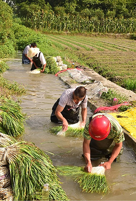
Figure 2. W Village farmers washing dirt and chemicals off their produce. Photograph by author, July 2017.
During our field surveys from 2017 to 2021, we interviewed 38 farmers and 2 local officials in depth about their perceptions of organic farming (Wu et al., 2018), the use of smart phones in the community, policies related to water source protection and resident relocation, and the newly emerging GMS. We also observed the implementation of GMS by shadowing the village's Grid Manager on one of his regular patrols. Among the 40 interviewees, there were 14 women and 11 persons over the age of 60. The grid manager was 26 years old, had 2 years' experience already as a patroller in this village, and was himself local to the area and familiar with the village. We then use vignettes (Dodge and Kitchin, 2005) to depict the interwoven relationship between the grid managers, farmers, entrepreneurs, and landscape management practices and explore how ICT technology might improve on the current water quality protection measures while also improving the ecological quality of farming practices and products. The perspectives attributed below to pseudonymous individuals are actually composites of frequently repeated views by multiple interviewees.
Emerging ICT-enabled governance and environmental management in rural Chengdu
In 2014, the GMS was proposed and then was quickly implemented in rural Chengdu. In this system the territory of a county (or urban district) was divided into many small “grids” according to population density and the administrative hierarchy from rural township or urban “street committee”; administrative village or urban community; to rural small group or urban neighborhood. The first-level grid uses the street (township) as the unit (about 30,000 inhabitants); the second-level grid uses the community (village committee) as the unit (about 2,000 inhabitants); the third-level grid is based on the farmer or resident small group (about one to three hundred inhabitants), etc. (Li et al., 2015). At the top of this system, an information center or platform under the supervision of the county (or district) government collects data directly from the townships and indirectly from the grids on the ground, at the village level. The local governments hired local people (mostly educated young people) working as grid managers who were responsible for reporting on the ground. In 2017 there were 1,460 grid managers, including 589 full-time and 871 part-time managers serving the GMS of the entire district to which W Village belongs (CPC news, 2020). Grid managers are required to fulfill some basic responsibilities, including (Figure 3):
• Collecting information about social conditions and public opinions;
• Coordination of social services;
• Emergency reporting and response;
• Mediation of conflicts and disputes;
• Maintaining and safeguarding social order;
• Administration of migrant population and vulnerable groups (e.g., elder, disabled) services;
• Reporting potential dangers and crimes, and
• Promotion of policies and regulations.

Figure 3. Grid manager main responsibilities and their smartphone interface (Photograph by author, July 2018).
The full-time grid managers were required to conduct at least two patrols per day in their own assigned grids, and the duration of each patrol should not be less than 2 hours. Their duties include visiting vulnerable groups (e.g., elders), migrant population (i.e., temporary inhabitants), and rental houses; monitoring environmental pollution (mainly water bodies, waste and garbage); fire prevention, and public security (including traffic safety and municipal facilities). They reported what they found immediately to the higher level of administrative departments through a specially designed mobile phone with GPS positioning (Figure 4). The information reported by these local managers would be gathered and analyzed quickly by local networks or the county's information center. Service platform functionaries could then guide local grid managers at different levels to jointly carry out actions in responding to emerging issues or inform government departments to provide services to local communities.
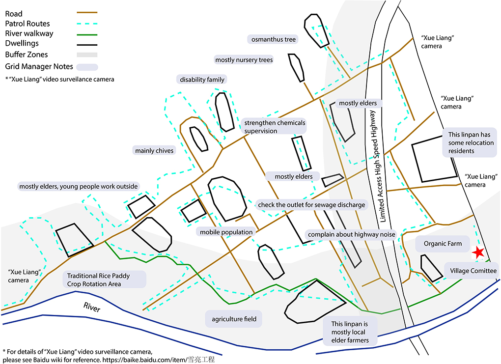
Figure 4. A patrol map of a grid manager in W Village (drawn by the grid manager, modified by the author). The map drawn by Mr. Wei reveals bottom-up data generation that is very fine-grained, providing details and interpretation of the place through his eye.
To motivate grassroots participation, and gain early awareness of conflicts among community members in order to resolve them in the public interest, district and township supervision centers formulated the principle “Instant Reward Measures for General Effective Information of Grid Service Management Work”, encouraging local residents and volunteers to report real-time issues or problems through the social media platform WeChat (Wei Xin Gong Zhong Hao). A specifically designed interface allows individuals to report events by clicking on buttons and filling in details. In other parts of China however, cities like Yinchuan also used WeChat groups (chatting groups) to fulfill such functions. Once the reported issues were verified, a certain cash reward ranging from 5 to 20 Yuan RMB per message would be given to the reporters.
We gradually incorporated inquiries about rural Chengdu's GMS in the course of conducting field surveys in W Village and elsewhere in 2017 and 2021. In 2017 we interviewed 38 farmers in W Village and focused on household demographics and income. In 2018, we asked a similar number of W Village farmers about their attitude toward smart phones, organic farming and e-commerce and interviewed the village grid manager and the owner of a local organic farm in depth. Meanwhile, we analyzed all 41 reports from the custom-built WeChat platform established specifically for the GMS in 2018 (but later eclipsed by larger, generic WeChat groups that farmers started joining in 2020). We found most of the reported events were related to emergencies, such as fires, leaking pipes, and conflicts between neighbors. However, during the field survey we also found that the older farmers and women were not actively involved in either the GMS or social media more broadly; 70% of them do not use (or admit to using) smartphones. Five out of seven women who agreed to be interviewed gave us their husbands' or children's cell phone numbers. The lack of assets and their low participation in local governance practices often hinder their contribution to agricultural extension programs and further lack of access to outside information.
Three vignettes below illustrate how different villagers' typical daily life circumstances may influence the impacts and potential of GMS, and how digital technology is related to cultural landscapes.
Grid manager, Wei (20s)
During the field survey to W Village in July 2018, we received permission from a grid manager (Mr. Wei, not his actual name) to observe his regular patrol in the assigned grid. Wei was born in W Village but had left to pursue higher education. This job was a rare opportunity for a local villager to return to his home village and use skills learned at university for village-based work. Wei usually patrolled twice a day in his village. He showed us his own hand drawn patrolling map (Figure 4) to see the main routes and points for which he was responsible. The map included notes he made of the community that did not always fit the rigid categories of data requested by the GMS app. Everyday Wei started his journey from the village committee (the red star in the map), occasionally accompanying a village leader. Driving his electrical van, he first visited the Z Organic Farm, an e-commerce company established in 2018. According to his notes, one priority of his job was visiting some low-income families and elder villagers whose children migrated or worked in cities. Those older farmers don't have physical ability to do agriculture anymore and may encounter many health-related inconveniences especially when their children are not with them. As for environmental monitoring, he used the officially designed smartphone app to report what he found, such as garbage dumping in canals and unapproved use of chemical pesticides in fields, which he geo-located in the app with GPS. He also recorded local complaints about such nuisances as noise from the newly constructed highway. He had some discretion to evaluate whether to report these issues to higher levels of the GMS. Some simple issues such as “necessity to clean the trash in the river” can be solved onsite; other events such as waste/pollution from a factory (not in this village) may need to be reported to and tackle by higher level administrators.
Farmer, Ms. Xiao (50s)
Accompanied by the grid manager, we visited Ms. Xiao in her newly constructed house. Her family's old linpan home was located inside the buffer zone of the second ring highway, so they were relocated recently. Her family moved to a new house (multi-story building) built by the local government (the developer) in a compact settlement cluster, and partly paid for with the cash compensation they received to relocate. In contrast to the old farm house, her new house was built with new materials such as concrete and tiled roofs and included modern amenities such as air-conditioning and WiFi. Her grandchild lived with her because her daughter and son were working in Chengdu city. She agreed that GMS was useful for her if she needed any help and liked to report to the manager in case any events (e.g., broken mobile bikes discarded in the apartment's courtyard) occurred.
Farmer, Mr. Chen (50s)
Some of the other farmers, of course, don't feel the GMS is useful because they prefer to interact with the village leadership directly instead of going through the grid managers. They feel the village leaders are the ones who can make a decision and they are already comfortable with their personal relationships with village committee members or the village head (cun zhang). From the group of farmers we interviewed, the majority of those who held this view were male, which suggests that established power relationships cannot simply be replaced by the new GMS. Most male farmers may prefer talking face to face to village leaders while female farmers may prefer talking to the grid managers and let the manager report their concerns using the app. Having alternative means of communication may improve the diversity of views that are heard.
Organic farm entrepreneur, Mr. Yang (30s)
Z Farm was a newly established small organic farm in W Village in 2018 when the relocation of villagers from buffer zones was implemented. The owner of this farm, Mr. Yang (not his actual name), is not local but from another town in northern Sichuan. Two employees were working for him who were responsible for the marketing and delivery subscription. There are two types of membership, the full membership is 2,980 RMB per year, which allows members to claim a plot of land (30 square meters) as a private vegetable garden; the farm's staff fully manages it and it includes 20 free delivery of fruits and vegetables to each member's address; a second type is the semi-managed membership costing 1,980 RMB per year. These members cultivate plots themselves, using organic fertilizer and biological pesticides covered by the membership fee. Monitors in the farm's office enable every customer to check the growth of crops and the working conditions of farm workers on their mobile phones at any time. The monitor also enables the farm's staff to check the situation of the fields, for example, for flooding during the rainy season. The function of this farm was comprehensive, providing not only organic foods but also leisure for urban visitors during weekends. Yang also acknowledged the benefits and convenience which the GMS manager provided such as easy communication with local government departments which he needs as an “outsider” who is unfamiliar with the local social and regulatory context. Through the digital platform, his products could be traded through the internet, which is changing the traditional production and trade models of the town in which W Village is located. Especially during and after the pandemic, when face-to-face buying and selling became impossible, this system greatly supported the recovery of farm production and the daily lives of local people.
Through the GMS's ICT technology, messages from the grassroots level were collected and reported to higher administrative departments who might then respond as soon as possible, strengthening the smooth flow of information within the hierarchy of authorities and agrarian society. Relying on this information platform, the district's GMS is operated through a two-way flow of information, i.e., bottom-up reporting and top-town intervention (Figure 5). The problems reported from local grid managers or villagers could be solved promptly through efficient action. The system is checked by occasional monitoring and mass satisfaction assessments (by local people) of the grid managers and the staff working in the administrative departments of township and county governments.
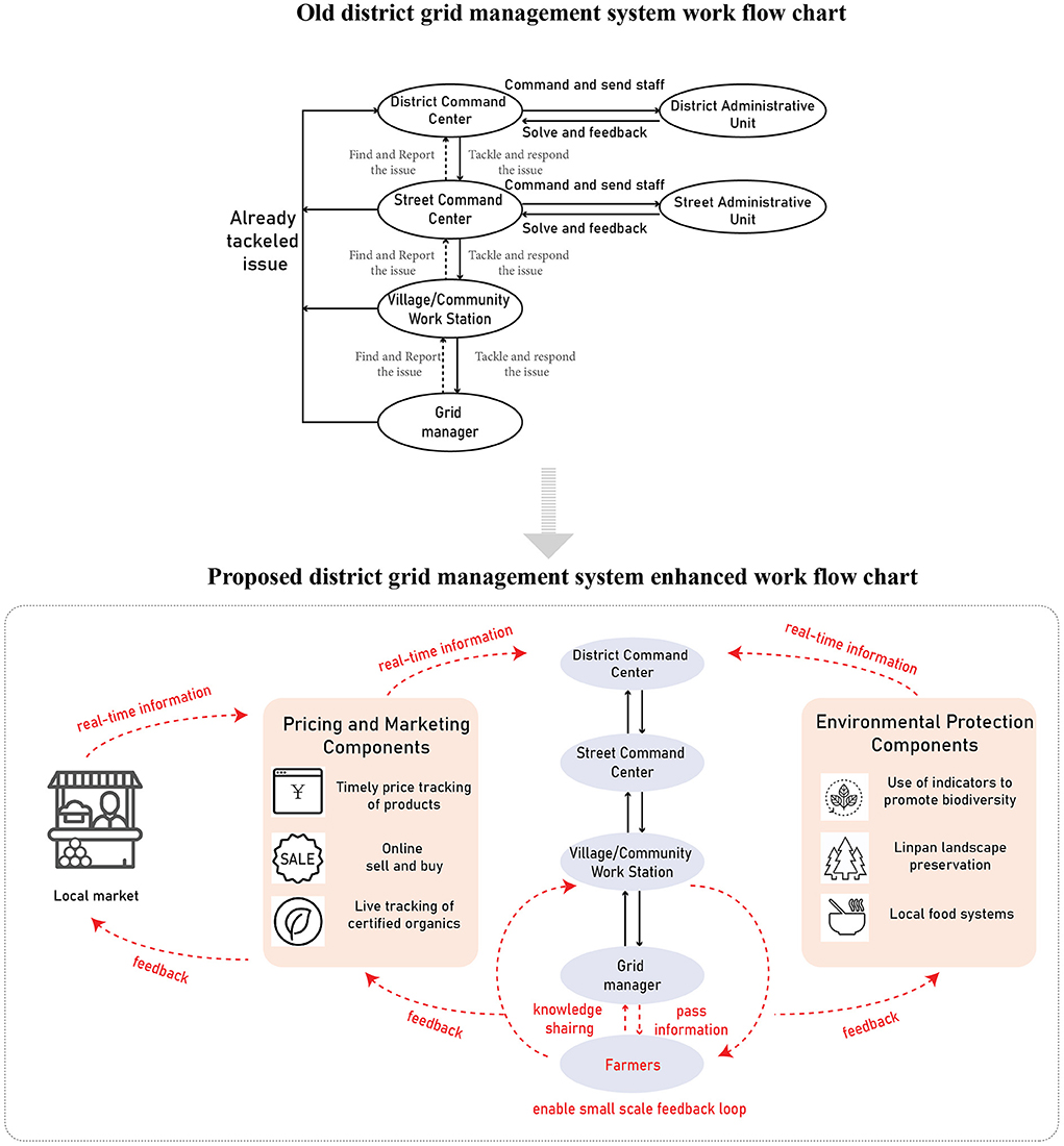
Figure 5. The proposed enhanced feedback loop. The proposed feedback loop could enable the big data gathered from the web to be passed through this net down to the lowest level. Grid managers, in this case, function as an important linkage between the ICT system and the vulnerable groups (e.g., elder farmers). They could deliver the message through personal interaction with local farmers. The old workflow chart is referenced from “Grid Manager Working Manual”, a hard copy provided by Mr. A.
In February 2020, the COVID-19 pandemic suddenly struck China including communities across the Chengdu Plain. This emerging shock tested the GMS in Chengdu's rural districts, and provides a perspective on social-ecological resilience in the Plain more generally. The GMS enhanced the reporting efficiency by monitoring this external shock and thus contributed to social resilience. Grid managers were required to regularly survey the status of virus infections and prevention measures, such as in-time reporting of PPE needs (e.g., face masks), disseminating hygenic knowledge, enforcing necessary 'social distancing' in villages, investigating health conditions of local inhabitants, and assisting vulnerable groups (Echinagov news, 2020). Under the guidance of the GMS platform, many volunteers were involved in the pandemic control through direct provision of necessary assistance to vulnerable groups. Moreover, while governments enforced lockdowns, the digital platforms became an important channel to disseminate information about the pandemic, effectively communicating and stimulating community collaboration to respond to external shock (Wu, 2020, 2022).
Room for improvement
In this section we discuss more speculatively the unrealized potential of GMS to enhance social-ecological resilience in the Chengdu Plain, by linking up with other digital practices and by enabling decision-makers at all levels, from individual household members up to the highest levels of government, to respond more sensitively to local conditions and increase both choice and coordination of land use. Apart from its piloting rural GMS programs, Chengdu is also considered a Pioneer City in implementing “Digital Villages” (Luo et al., 2021). However, the lack of digital participation of elder and female farmers in GMS indicates a gap in beneficiaries. The personal intervention of the Grid Manager became an essential element of GMS for elders or households whose income-earning members had migrated out of the village. The GMS could also help agrarian communities in the Plain maintain or restore their historic high-levels of organic agricultural productivity (especially in food), population density, biodiversity, forest cover, and flood and drought resilience. Relocating farming households out of environmentally critical areas has not adequately addressed this challenge.
For the GMS to enable an alternative solution—to monitor water quality without moving all farmers out of the drinking water buffer zone—it must enhance its regulatory function and also include a marketing function (Figure 5). On the regulatory, environmental protection side, the system could be used to track how farmers and village authorities within the buffer zones are managing their farms and maintaining a non-polluting, ecologically healthy landscape. The indicators of spatial resilience summarized above in Section Emerging ICT-enabled governance and environmental management in rural Chengdu could be used as input attributes for on-going monitoring. If farmers adopt practices that align with these linpan landscape preservation attributes, they may be permitted to live in the buffer zones without relocation. In order to make compliance more economically rewarding, the GMS's ICT-based tools could trace and verify participating farmers' production and establish a rating system for purposes of marketing and commanding higher prices in the growing market for organic agriculture in the region (Kim, 2014). Finally, this system and its in-time information loop should track the changing markets and incorporate more information that is not easily accessible by farmers such as daily updates of agricultural products' price, which could help them adjust their cultivating or trading activities. A web crawler1 can crawl agricultural products' prices on a daily basis (from governmental or private companies' websites). This information often has location information in it which can be geocoded and used in geospatial analysis, even down to the scale of the field. Farmers and consumers could both benefit from using this type of app; rather than relying on middlemen and wholesale supply chains, farmers would have more direct contact through apps with consumers, knowing their demands and delivering products. More direct producer-to-consumer marketing would allow farmers to capture a greater share of produce prices and be more likely to support a diversity of agricultural products on each farm, which could align better with traditional polycultural practices based on the heterogeneity of the linpan landscape.
Out of a series of 40 interviews with W Village farmers between 2017 and 2021, we chose 10 interviewees from this group, and in 2021 we asked them about the idea we proposed in the above paragraph. While the small sample prevents statistical generalization, our aim was rather to use “vignettes” qualitatively to identify potentially important social positions vis a vis environmental change, and to identify potential problems of this new technology, which is useful for us to think about the how to make this technology more accessible to everyone. The 2021 interviews made it clear that the older farmers' lack of familiarity with smartphone technology would be a barrier to immediate and widespread implementation. Younger, more tech-savvy and more formally educated members of the community, such as the grid managers themselves, would need to work with the older generation to realize the benefits of the technology and integrate it with policy implementation. At the same time, elders' knowledge of traditional practices and environmental history would be crucial for “ground-truthing” and validating the indicators and attributes the GMS would measure. In the process, younger generations would absorb this local agro-ecological knowledge—a result that is itself a hallmark of socio-ecologically resilient productive landscapes (Bergamini et al., 2013, p. 16).
Summary and outlook
The linpan agro-ecosystem is a traditional cultural landscape that has been developed over time through the interaction between people and their environment. Its structure, dynamic process, and inter-linkages are characterized by long historical persistence and a strong connection with the local environment and governance system. With rapid socio-economic development in the last decade, especially the popular use of ICT-based tools, the agricultural activity, livelihood and even governance system of local communities has changed. As China continues its dramatic transition to the digital environment in rural areas, there is an urgent need and opportunity to elevate data publicity when tackling new challenges (World Economic Forum, 2020). The GMS which was introduced into rural Chengdu recently, promoting two-way communication, i.e., bottom-up and top-down, has provided a promising new channel for societal feedback and has contributed to effective decision making. In the face of external shocks, for instance, most recently the COVID-19 pandemic in 2020, the efficiency and effectiveness of GMS and other ICT-based tools has provided dispersed linpan settlements and agrarian society with in-time response, allowing the system to activate its adaptation mechanism, and reduce losses. By interacting with a more transparent, multi-directional and less hierarchical version of GMS, local people will build trust and robust ties within and beyond their community, including with local bureaucratic authorities, which will be beneficial to resilient governance in the future.
Although the measurement of spatial resilience indicators that initially motivated this research did not result in specific design guidelines for rural development projects, it now appears that these measurements may have new relevance, through the possible development of a regulatory and marketing tool that bridges scales between regional water quality management goals and the aspirations and needs of farmers. New technologies of governance and marketing that are just now being introduced to rural communities in Chengdu might enable (1) regulators to monitor spatially fine-grained agricultural practices to ensure their ecological sustainability without requiring extensive reorganization of the agrarian landscape, and (2) farmers to benefit by promoting these practices and their products to a wider and more informed market.
However, the current GMS feedback loop is not as inclusive or as responsive as it could be, nor as relevant to some of the most pressing policy concerns. Elder farmers, particularly women, have limited access to or fluency with smartphones and apps, and thus their voices are rarely reflected in the GMS-based decision-making process. Training and knowledge dissemination for these marginalized groups are still needed (UN FAO, 2018). Instead of oppressing traditional rural communities with the new technology, we hope this newly emerging ICT application could empower rural society by enhancing its social learning processes, changing the asymmetrical data flow, and providing multiple choices related to individual and community livelihood. We encourage stakeholders including government officials, scholars, data scientists, designers, and the broader public to re-think the “human-world-technology” relationship (Verbeek, 2001) and improve the apps accordingly as they relate to rural settings in recently urbanizing areas. We see new opportunities for ICT-based governance to promote urban-rural co-development and systematic resilience, by carefully examining and including local distinctness, and integrating high-tech innovations with low-tech place-based ecological knowledge and practices.
Data availability statement
The python crawler codes generated for this study are available on request to the corresponding author.
Ethics statement
Ethical review and approval was not required for the study on human participants in accordance with the local legislation and institutional requirements. Written informed consent for participation was not required for this study in accordance with the national legislation and the institutional requirements. The names of the interviewees and places have been replaced with pseudonyms. The original map has been modified by the authors to protect the human subjects.
Author contributions
Conceptualization and literature review: SW and DA. Fieldwork and writing—review and editing: SW, DA, and BZ. Writing—original draft preparation: SW. Supervision: DA. All authors contributed to the article and approved the submitted version.
Funding
SW gratefully acknowledges and appreciates funding from the University of Washington (UW) Quaternary Research Center, UW College of Built Environments Dean's Dissertation Grant, and a UW Jackson School of International Studies China Studies Fellowship for supporting this academic research and field survey. This research was funded partly by the Sichuan Science and Technology Bureau, China (Grant No. 2020YFS0025). A UW Jackson School of International Studies Area and International Studies grant for-New Urban-Rural Relations in Asia: Trans-Pacific Perspectives on Resilient City-Regions paid for the article processing fee.
Acknowledgments
The authors would like to thank students and faculty from Chengdu who helped in the fieldwork. The first author would like to thank members of her doctoral committee, Bo Zhao, Manish Chalana and Monica Moskal at University of Washington and Stevan Harrell for their general suggestions in this study. Special thanks to Bo Zhao who provided numerous valuable literature and guidance on the Python crawler. The authors are also grateful for suggestions by the Urban-Rural Linkages and Sustainable Regional Development Working Group at the APRU Sustainable Cities and Landscapes Conference (2020). As usual, any errors or shortcomings of the paper are the authors' alone.
Conflict of interest
The authors declare that the research was conducted in the absence of any commercial or financial relationships that could be construed as a potential conflict of interest.
Publisher's note
All claims expressed in this article are solely those of the authors and do not necessarily represent those of their affiliated organizations, or those of the publisher, the editors and the reviewers. Any product that may be evaluated in this article, or claim that may be made by its manufacturer, is not guaranteed or endorsed by the publisher.
Footnotes
1. ^We built a python crawler to get daily price data from a website called “Hui Nong” (https://www.cnhnb.com/). The codes can be provided upon request.
References
Abramson, D. B. (2016). Periurbanization and the politics of development-as-city-building in China. Cities 53, 156–162. doi: 10.1016/j.cities.2015.11.002
Abramson, D. B. (2020a). Ancient and current resilience in the Chengdu Plain: agropolitan development re-‘revisited'. Urban Stud. 57, 1372–1397. doi: 10.1177/0042098019843020
Abramson, D. B. (2020b). “Eco-developmentalism in China's Chengdu Plain,” in Greening East Asia: The Rise of the Eco-Developmental State, eds A. Esarey, M.A. Haddad, J. Lewis, and S. Harrell (Seattle, WA: University of Washington Press), 164–180.
Abramson, D. B., and Qi, Y. (2011). “Urban-rural integration” in the earthquake zone: Sichuan's post-disaster reconstruction and the expansion of the Chengdu metropole. Pac. Aff. 84, 495–523. doi: 10.5509/2011843495
Agrawal, A., and Perrin, N. (2009). “Climate adaptation, local institutions and rural livelihoods,” in Adapting to Climate Change: Thresholds, Values, Governance, eds W. Adger, I. Lorenzoni, and K. O'Brien (Cambridge: Cambridge University Press), 350–367. doi: 10.1017/CBO9780511596667.023
Bergamini, N., Blasiak, R., Eyzaguirre, P. B., Ichikawa, K., Mijatovic, D., Nakao, F., et al. (2013). Indicators of Resilience in Socio-Ecological Production Landscapes (SEPLs). Available online at: https://satoyama-initiative.org/old/wp-content/uploads/2013/08/Indicators-of-resilience-in-sepls_ev.pdf (accessed July, 2021).
Birnbaum, S. E., and Yu, X. (2006). NGO strategies to promote river protection and restoration. China Environ. Ser. 8, 185–190.
Bray, D. (2013). Urban planning goes rural: conceptualising the “new village.” China Perspect. 3, 53–62. doi: 10.4000/chinaperspectives.6273
Carpenter, S. R., and Brock, W. A. (2008). Adaptive capacity and traps. Ecol. Soc. 13, 40. Available online at: http://www.ecologyandsociety.org/vol13/iss2/art40/
Chen, A., and Gao, J. (2011). Urbanization in China and the coordinated development model—the case of Chengdu. Soc. Sci. J. 48, 500–513. doi: 10.1016/j.soscij.2011.05.005
Chen, J.-C., Zinda, J. A., and Yeh, E. T. (2017). Recasting the rural: state, society and environment in contemporary China. Geoforum 78(Suppl. C), 83–88. doi: 10.1016/j.geoforum.2016.03.014
Cheung, A. S. Y., and Chen, Y. (2021). From datafication to data state: Making sense of china's social credit system and its implications. Law Soc. Inq. 1–35. doi: 10.1017/lsi.2021.56
Cieslik, K., Cecchi, F., Damtew, E. A., Tafesse, S., Struik, P. C., Lemaga, B., et al. (2021). The role of ICT in collective management of public bads: The case of potato late blight in Ethiopia. World Develop. 140, 105366. doi: 10.1016/j.worlddev.2020.105366
Cieslik, K., and Margócsy, D. (2022). Datafication, power and control in development: a historical perspective on the perils and longevity of data. Prog. Dev. Stud. 25, 14649934221076580. doi: 10.1177/14649934221076580
Cox, A. J., and Sseguya, H. (2015). ICT Supported Extension Services in Conservation Agriculture Information Access for Small Holder Farmers in Laikipia County, Kenya. 2015 IEEE International Symposium on Technology and Society (ISTAS), IEEE, 1–6. doi: 10.1109/ISTAS.2015.7439408
CPC news (2020). Grid Members Praised By The Public.Available online at: http://cpc.people.com.cn/n1/2020/0212/c166757-31583447.html (accessed February 12, 2020).
Cumming, G. S., Cumming, D. H., and Redman, C. L. (2006). Scale mismatches in social-ecological systems: Causes, consequences, and solutions. Ecol. Soc. 11, 14. doi: 10.5751/ES-01569-110114
Curran, D., and Smart, A. (2021). Data-driven governance, smart urbanism and risk-class inequalities: security and social credit in China. Urban Stud. 58, 487–506. doi: 10.1177/0042098020927855
Dodge, M., and Kitchin, R. (2005). Code and the transduction of space. Ann. Assoc. Am. Geograph. 95, 162–180. doi: 10.1111/j.1467-8306.2005.00454.x
Echinagov news (2020). The Whole Area is Divided into 647 Comprehensive Grids. Chengdu's Pidu District Uses a “Four-Level Grid” to Densely Weave the Epidemic Prevention and Control Network. Available online at: http://www.echinagov.com/info/289116 (accessed December 14, 2020).
Gong, Y. (2019). “Rental housing: surveillance of rural migrants,” in Manufacturing Towns in China: The Governance of Rural Migrant Workers (Singapore: Springer), 111–140.
Gunderson, L. H. (2002). Panarchy: Understanding Transformations in Human and Natural Systems. Washington DC: Island press.
Hale, M. A. (2013). Reconstructing the rural: peasant organizations in a Chinese movement for alternative development (Dissertation). University of Washington, Seattle, WA.
Hu, J. (2015). Coming home to the land: natural farming as therapeutic landscape experience in the Chengdu Plain, China (Dissertation). University of Washington, Seattle, WA.
Hu, J., and Abramson, D. B. (2015). “Visions of new urban-rural relations and alternative definitions of well-being in rapidly urbanizing China: the case of Chengdu, Sichuan,” in Transforming Distressed Global Communities: Making Inclusive, Safe, Resilient, and Sustainable Cities, eds F. Wagner, R. Mahayni, and A. Farnham Piller (Surrey, Burlington, VT: Ashgate), 317–337.
Jiang, J. (2022). A question of human rights or human left? – the ‘people's war against COVID-19' under the ‘gridded management' system in China. J. Contemp. China 31, 491–504. doi: 10.1080/10670564.2021.1985827
Kim, S. M. (2014). Shunning the authority: symbolic purity and autonomy in consuming non-certified organic foods in Chengdu, China (Thesis). University of Washington, Seattle, WA.
Kostoska, O., and Kocarev, L. (2019). A novel ICT framework for sustainable development goals. Sustainability, 11, 1961. doi: 10.3390/su11071961
Li, W., Liu, H., Yu, Z., Li, J., and Zheng, X. (2015). Analysis of characteristics of grid environment management and implementation suggestions (Wang Ge Hua Huan Jing Guan Li Te Zheng Fen Xi Ji Shi Shi Jian Yi). China Environ. Manage. (Zhong Guo Huan Jing Guan Li) 7, 56–68. doi: 10.16868/j.cnki.1674-6252.2015.01.010
Luo, B., Shen, X., Zhao, K., and Qin, S. (2021). Environmental Big Data Driving Management Transformation. Available online at: https://www.cenews.com.cn/opinion/plxl/202009/t20200915_958798.html (accessed May 02, 2021).
Mittelstaedt, J. C. (2021). The grid management system in contemporary China: grass-roots governance in social surveillance and service provision. China Inform. 36, 3–22. doi: 10.1177/0920203X211011565
Mol, A. P. J. (2009). Urban environmental governance innovations in China. Curr. Opin. Environ. Sustain. 1, 96–100. doi: 10.1016/j.cosust.2009.07.002
Ostrom, E. (2009). A general framework for analyzing sustainability of social-ecological systems. Science. 325, 419–422. doi: 10.1126/science.1172133
Peng, L. P., Wang, C. J., and Onitsuka, K. (2017). Collaborative conservation of a socio-ecological production landscape through ICT tools. Environments 4, 63. doi: 10.3390/environments4030063
Schroeder, R. (2014). Big Data and the brave new world of social media research. Big Data Soc. 1, 2053951714563194. doi: 10.1177/2053951714563194
Shi, W. (2019). Conflict and fusion: dual paradox and transition of grid governance and rural autonomy: based on the field experience of Q village in Chengdu (Xiang Cun Wang Ge Hua Zhi Li Yu Cun Min Zi Zhi De Chong Tu Yu Rong He – Ji Yu Cheng Du Q Cun Wang Ge Hua Zhi Li Shi Jian Li Tu Xing De Si Kao). Western Forum (Xi Bu Lun Tan) 6, 44–52.
Tang, B. (2020). Grid governance in China's urban middle-class neighbourhoods. China Q. 241, 43–61. doi: 10.1017/S0305741019000821
Tian, Y. (2012). Position and future of grid management model in city governance (Cheng Shi She Hui Guan Li Wang Ge Hua Mo Shi De Ding Wei Ji Qi Wei Lai). Study and Exploration (Xue Xi Yu Tan Suo) 2, 34–38.
Tippins, J. L. (2014). Planning for resilience: a proposed landscape evaluation for redevelopment planning in the Linpan landscape (Thesis). University of Washington, Seattle, WA.
UN FAO (2018). 7 Success Factors to Empowering Rural Women Through ICTs. Available online at: http://www.fao.org/fao-stories/article/en/c/1105823/ (accessed June 5, 2021).
Verbeek, P. (2001). Don Ihde: The Technological Lifeworld. in American Philosophy of Technology: The Empirical Turn. (Bloomington, IN: Indiana University Press), 119–146.
Wang, X. (2015). Accessibility and population density in the Linpan landscape: a study of urbanization in the Chengdu Plain, Sichuan, China (Thesis). University of Washington, Seattle, WA.
Webster, C. W. R., and Leleux, C. (2018). Smart governance: opportunities for technologically-mediated citizen co-production. Inform. Polity: Int. J. Govern. Democracy Inform. Age 23, 95–110. doi: 10.3233/IP-170065
Whiting, S. H., Abramson, D. B., Yuan, S., and Harrell, S. (2019). A long view of resilience in the Chengdu Plain, China. J. Asian Stud. 78, 257–284. doi: 10.1017/S0021911819000111
Wilczak, J. (2017). Making the countryside more like the countryside? Rural planning and metropolitan visions in post-quake Chengdu. Geoforum, 78, 110–118. doi: 10.1016/j.geoforum.2016.10.007
World Economic Forum (2020). How China's Digital Farmers Can Grow a Post-COVID-19 Future. Available online at: https://www.weforum.org/agenda/2020/10/how-digital-farmers-in-china-can-grow-a-post-covid-19-future/ (accessed October 15, 2020).
Wu, S. (2020). “Rethinking the socio-ecological resilience of linpan rural landscape under the threat of COVID-19,” in Rethinking Sustainable Pacific Rim Territories, Proceedings of the 2020 APRU Sustainable Cities and Landscapes Hub PhD Symposium, edited by Paola Boarin, Errol Haarhoff, Manfredo Manfredni, Mohsen Mohammadzadeh, Alessandro Premier (Auckland, New Zealand: University of Auckland School of Architecture and Planning), 177–186. doi: 10.17608/k6.auckland.13355936.v2
Wu, S. (2022). Assessing Resilience in the Spatial Patterns and Socio-ecological Functions of the Chengdu Plain (Doctoral Dissertation). Seattle, WA: University of Washington. Available online at: https://digital.lib.washington.edu/researchworks/handle/1773/48844
Wu, S., and Abramson, D. B. (2019). Rural Resilience in Chengdu Plain, A Multi-scale Perspective. American Association of Geographers Annual Conference. Presentation, Washington DC.
Wu, S., Du, Y., Mi, M., and Zhang, Y. (2018). Organic Farming in Linpan Landscape. APRU sustainable cities and landscapes conference. Presentation, Hongkong.
Wu, S., Wu, N., and Zhong, B. (2020). What ecosystem services flowing from linpan system—a cultural landscape in Chengdu Plain, Southwest China. Sustainability 12, 4122. doi: 10.3390/su12104122
Xiao, L. (2015). Buying time for the farmers of Chengdu: Settlement form, labor time allocation, and their implications for resilient land use planning in a rapidly urbanizing region (Thesis). University of Washington, Seattle, WA, United States. Available online at: http://hdl.handle.net/1773/34198
Yan, Y. (2006). Characteristics and implications of city grid management (Cheng Shi Wang Ge Hua Guan Li De Te Dian Ji Qi Shi). Urban Issues (Cheng Shi Wen Ti) 2, 76–79.
Ye, Y., and LeGates, R. (2013). Coordinating Urban and Rural Development in China: Learning from Chengdu. Cheltenham, UK and Northampton MA USA: Edward Elgar Publishing.
Zhang, N., Liao, Z., Wu, S., Nobis, M. P., Wang, J., and Wu, N. (2022). Impact of climate change on wheat security through an alternate host of stripe rust. Food Energy Secur. 11:e356. doi: 10.1002/fes3.356
Zhang, S., Zhao, B., Tian, Y., and Chen, S. (2021). Stand with# standingrock: envisioning an epistemological shift in understanding geospatial big data in the “post-truth” era. Ann. Am. Assoc. Geograph. 111, 1025–1045. doi: 10.1080/24694452.2020.1782166
Zhong, B., Wu, S., Wu, N., and Sun, G. (2022). Farmers' strategies to climate change and urbanization: potential of ecosystem-based adaptation in rural Chengdu, Southwest China. Int. J. Environ. Res. Public Health 19, 952. doi: 10.3390/ijerph19020952
Zhu, L. (2018). Comparative research on rural redevelopment planning in the Linpan landscape: case study of Sandaoyan Town, Chengdu (Thesis). University of Washington, Seattle, WA.
Zhu, Q. W. (2012). Public service process re-engineering: from “seamless government” to grid management. J. Public Admin. 5, 1–21.
Zhu, R., and Wu, W. (2014). From grid management to cooperative governance: analyzing the evolution path of community governance model in China during the transition period (Cong Wang Ge Zhi Li Dao He Zuo Gong Zhi – Zhuan Xin Qi Wo Guo She Qu Zhi Li Mo Shi Lu Jing Yan Jin Fen Xi). J. Xiamen Univ. (Arts Soc. Sci.) (Xia Men Da Xue Xue Bao) 1, 102–109.
Keywords: digital governance, socio-ecological resilience, linpan landscape, grid management system (GMS), Chengdu Plain, environmental management
Citation: Wu S, Abramson DB and Zhong B (2022) Digital governance in rural Chengdu, China: Its potential for social-ecological resilience. Front. Sustain. Cities 4:736965. doi: 10.3389/frsc.2022.736965
Received: 06 July 2021; Accepted: 22 August 2022;
Published: 30 September 2022.
Edited by:
Yizhao Yang, University of Oregon, United StatesReviewed by:
Jesper Zeuthen, Aalborg University, DenmarkLei Zhang, Renmin University of China, China
Copyright © 2022 Wu, Abramson and Zhong. This is an open-access article distributed under the terms of the Creative Commons Attribution License (CC BY). The use, distribution or reproduction in other forums is permitted, provided the original author(s) and the copyright owner(s) are credited and that the original publication in this journal is cited, in accordance with accepted academic practice. No use, distribution or reproduction is permitted which does not comply with these terms.
*Correspondence: Shuang Wu, shuangw1@uw.edu