The Trajectory of the Landscape and Functionality of Urban Watercourses: A Study of Lavras City, Brazil
 Rafael de Brito Sousa1,2
  Patrícia Duarte de Oliveira Paiva2*
  Michele Valquíra dos Reis2
  Nathalie Carcaud1,3
- 1Université d'Angers UMR6590 ESO, Angers, France
- 2Departamento de Agricultura, Universidade Federal de Lavras, Lavras, Brazil
- 3Institut Agro—Agrocampus Ouest, Angers, France
The growth of the urban population promotes a strong pressure to occupy open spaces in urban center, including around watercourses. Canalization and drainage techniques favored urban expansion and occupation of these spaces. In long term, this has not been efficient, since it is not a sustainable decision, mainly in view of the challenges provided by climate change. The purpose of this work was to analyze the modification of the landscape and multifunctionality of the urban watercourses in relation to socioeconomic and environmental scope of the evolution of an urban area using Lavras city, Brazil, as model. For that, city's hydrographic grid was drawn from the digital elevation model (DEM) corrected by manual vectorization after field visits and analysis of high-resolution images. To understand natural and sociocultural evolution processes, a compilation of geo-historical information about the origin and formation of the city was made using Patchwork Quilt methodology. To understand the actions and perceptions of different actors from urban watercourses in Lavras, questionnaires were applied to the population, and interviews were directed to the public and private managers. It was observed that the watercourses and their surroundings lost a large part of their natural, social, and economic functions, after the 1980s, only having a drainage function. The areas in expansion prioritize the natural function preservation but lack the incentive to implement the other functions such as social and economic. With the economic valuation of land, the implementation of green and blue infrastructure has not yet been prioritized. Even with the legislation that provides multifunctional uses for rivers and their banks, the urban watercourses from Lavras remained largely monofunctional. This did not contribute to increasing the city's green areas and the reintegration of watercourses into the urban landscape. The population values the water present in the urban landscape and yearns for multifunctional solutions such as green areas and urban gardens. Public and private actors recognize the lack of clarity in the legislation, and in the definition of concepts and techniques to be adopted. Multifunctional solutions can be in favor of reconciling different interests, promoting the reintegration of rivers into the urban landscape.
Introduction
The emergence of the first cities and urban developments has always been linked to watercourses (Garcia et al., 2011; Baptista and Cardoso, 2013; Coy, 2013; Alves et al., 2017). These have always been important elements for establishing human settlements, not only as a vital asset, but also as input for agriculture, means of communication and transportation of goods, and aesthetic, spiritual and cultural values (Everard and Moggridge, 2012; Coy, 2013; Yeakley et al., 2016).
However, with the industrial revolution, unrestrained urban growth became one of the main factors for reducing the resilience of cities (Moreira and Vitorino, 2019). The suppression of natural ecosystems had generated different environmental problems, such as the increase in heat islands, air pollution, floods, among others (Foloni and Constantino, 2016; Martines et al., 2020). Due to climate change, the effects of these problems are going to be strongly noticed in a local scale (IPCC, 2013; PBMC, 2016).
As a result, greater attention has been given to urban areas to propose solutions to environmental problems and reconcile economic development with the preservation of natural resources, especially watercourses and springs. From the Rio conference in 1992, the notion of “multifunctionality” arose (Selmi et al., 2013). Initially studied in the agriculture and forestry fields, multifunctionality is broadly defined as a set of environmental, social and economic functions (Hervieu, 2002; Wiggering et al., 2006), the three pillars of sustainability.
This concept gradually extended to different landscape structures in both rural and urban areas (Kato and Ahern, 2009), such as the ecological corridors, already widespread in other countries (Cormier et al., 2010), with denominations like Green and Blue infrastructure (GBI) or “Greenways” (Ahern, 1995). The advantage of urban watercourses (known as Blue Infrastructure) over green areas (corresponding to Green Infrastructure) is that they work as both reservoirs and corridors for biodiversity (Lamond and Everett, 2019).
In Brazil, the concept of ecological corridor was established through the Permanent Preservation Zones (PPZs)—Law No. 12,651 of 2012 of the Brazilian Forest Code being defined as legally protected, fragile and environmentally vulnerable spaces, consisting of public or private land, urban or rural, covered or not by native vegetation (BRASIL, 2012). However, there are many conflicts concerning the use and occupation in urban PPZs in Brazil, among which are the canalization of watercourses and occupation of their banks by low-income population (Meirelles Filho and Miranda, 2016; PBMC, 2016; Rezende and Araújo, 2016).
The maintenance of PPZs in an urban environment can offer several ecosystem functions, which can be grouped into four categories: regulation, habitat, production, and information (De Groot et al., 2002). As a result, there are several ecosystem services (ES) assigned to these areas, ranging from health, leisure and entertainment, reduction of damage from environmental problems and biodiversity reserves (CONAMA, 2006; Cormier et al., 2010; Laugier, 2010; BRASIL, 2012), in addition to an essential role in urban sustainability (Coutts and Hahn, 2015; Kim and Coseo, 2018).
According to McDonald (2009) and Clergeau (2012), one of the challenges of public policies is correlating ecosystem services and multifunctionality. Considering the complexity of urban ecosystems, the integration of the ES concept within the decision process can contribute to advances in biodiversity preservation in urban areas. This is confirmed by the authors Zinia and Mcshane (2018) for the city of Dhaka, Bangladesh. The actions of local governments in relation to GBI are fundamental for the development of more resilient and sustainable cities and should minimize the effects of climate change (Teixeira and Pessoa, 2020).
Lavras is an example of a municipality that has land use and occupation conflicts in its PPZs (Reis et al., 2012). The city has an Index of Green Areas below to the one recommended by the Brazilian Society for Urban Afforestation (15m2/inhabitant), in addition, there is not a homogeneous distribution (Boldrin et al., 2016; Garcia et al., 2021).
Located in the transition zone between the Atlantic Forest and Cerrado biomes, Lavras has some remnants of endemic species of fauna and flora, and proven importance of its forest fragments for the maintenance of biodiversity in urban areas (Lombardi et al., 2012; Lopes and Peixoto, 2018; Cruz and Pompeu, 2020). However, in these areas, water erosion and gullies are also common, aggravated by the absence of vegetation and soil impermeability in urban basins (Furtini et al., 2007; Guimarães et al., 2012).
In this context, the objective was to analyze the modification of the landscape and multifunctionality of the urban watercourses in relation to socioeconomic and environmental scope of the evolution of an urban area using Lavras city, Brazil, as model.
This study allows to answer some questions as: How the evolution of the city's watercourses and surrounds occurred concerning the socioeconomic and environmental scope? How the changes in the uses and occupation of urban land around springs and rivers in a city, may be understand through a geo-historical analysis taking social dimensions, economic and environmental aspects? What is the perception of the population and public actors in relation to blue infrastructure in a city?
Materials and Methods
The City of Lavras
The study area corresponds to the region within the urban perimeter of the municipality of Lavras (Figure 1). This city is located in the Campo das Vertentes region, in the south of Minas Gerais, Brazil, latitude 21°13′35″S, longitude 44°58′43″W, and average altitude of 918 meters. The climate is rainy temperate (mesothermal) with dry winter and rainy summer, subtropical, class Cwa, according to the Köppen climate classification (Dantas et al., 2007). The municipality has a total area of 564.7 km2. According to the estimated population census for 2018, the population is ~103,773 inhabitants, 95% of them living in the urban area (IBGE, 2018).
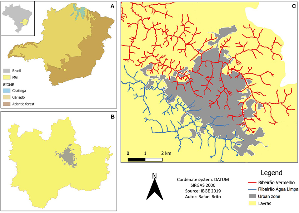
Figure 1. The State of Minas Gerais, Brazil (A). The municipality of Lavras (B) Geographic location of the urban area of Lavras and its main basins (C).
The urban area of Lavras is mainly established on two micro-basins, the Ribeirão Vermelho and the Ribeirão Água Limpa, both tributaries of the Alto Rio Grande basin. The municipality's territory presents the montane seasonal semideciduous forest as the predominant forest formation, with areas of countryside, rupestrian field and cerrado (Carvalho and Scolforo, 2008) (Figure 1).
Delimitation of the Study Zone Around Urban Watercourses
The study area was delimited based on Art. 4 of Law No. 12,651 of May 25, 2012 of the Brazilian Forest Code, which defines permanent preservation areas around watercourses and springs, with 30 m for watercourses <10 m wide, and 50 m for areas around springs (BRASIL, 2012).
Based on this law, and using QGIS 3.16.1 software (QGIS Development Team, 2017), the city's hydrographic grid was drawn from the digital elevation model (DEM) available in the City Hall database, corrected by manual vectorization after field visits and analysis of high-resolution images. The springs were determined considering the beginning of watercourses. For the delimitation of PPZs, a buffer zone was created around springs and watercourses based on the limits imposed by the law.
As this study focuses on watercourses crossing urban areas, only the PPZs around springs and watercourses that compose the two main hydrographic basins in the urban area of Lavras were analyzed: Ribeirão Vermelho and Ribeirão Água Limpa.
The Master Plan of the city of Lavras, described by Complementary Law No. 097, of April 17, 2007, defines the delimitations of the urban zone (UZ) according to the availability of infrastructure, the densification capacity, and the degree of nuisance and pollution of the urban environment (PML, 2007). Also, it should consider areas that offer at least two urban services, such as sanitation, lighting, etc. (BRASIL, 1966).
In this work, only the urbanized area within the urban perimeter until the year 2019 was analyzed, following its evolution. The methodology aimed at analyzing how natural, sociocultural, economic processes, as well as their interactions, materialize in the landscape of urban watercourses and how public policies contribute to this. For the analysis, three methodologies were combined: geo-historical landscape analysis, quantitative analysis of land use and occupation around watercourses and quali-quantitative analysis (questionnaires and interviews).
Geo-Historical Analysis of the Landscape Around Watercourses
To understand the evolution of natural and sociocultural processes, a compilation of geo-historical information about the origin and formation of the city was made through bibliographies, iconographies, and topographic maps from 1898 to 1975, according to the Patchwork Quilt methodology (Paiva et al., 2021). Aerial photographs from 1958 to 2019 available at the Minas Gerais Public Archive (APM, 2021) were also used, as well as the personal archives of local historians.
All maps and aerial photographs were georeferenced and processed based on the most recent images available, referring to the year 2019. Geoprocessing used the QGIS 3.16.1 software (QGIS Development Team, 2017) following the cartographic standardization proposed by Menezes and Fernandes (2016). Subsequently, the changes in the landscape of watercourses and springs were analyzed according to the social, economic and environmental dimensions, by identification in bibliographic records.
Quantitative Analysis of Land Use and Occupation Around Watercourses
Based on the most recent image, referring to year 2019, a classification of land use and occupation was made through the method of visual interpretation and manual vectorization. They were quantified and separated into three categories:
• Impermeable areas—built up zones and/or paved areas with non-permeable surfaces.
• Herbaceous vegetation and other permeable areas—herbaceous formations (lawn and pasture, arable land, gardens); wood plants formations such as vineyards and lianas (vines) and Zones with mineral material (rock-earth, railways, trails, flowerbeds, salt marshes).
• Arboreal vegetation (wooded spaces)—arboreal formations with a predominance of broadleaved and coniferous trees with variable surface (from woodland to forest). Shrub and sub-shrub formation.
The choice of this method is justified by the presence of shadow and high spatial resolution of the images, which hinders their automatic classification. Furthermore, specific landscape factors can be better interpreted visually (Antrop and Van Eetvelde, 2000).
The results obtained were related to the current environmental, social, and economic uses of these spaces in an attempt to identify possible combinations of uses in a functional way, for instance, with the implementation of green and blue infrastructures. These are provided for in the Urban Zoning of the Municipality for some areas around watercourses:
• Economic Activity Zone (Zona de Atividade Econômica—ZAE): areas suitable for diversified economic uses, in conflict with general residential use and suitable for installation along the main accesses to the city.
• Special Zone of Historic-Cultural Interest (Zona Especial de Interesse Histórico e Cultural—ZEIHC): areas listed in the patrimonial inventory of the city, where it is necessary to protect cultural heritage, considering everything that comprises culture, identity, reference, memory and the symbolism of society.
• Special Zone of Urban-Environmental Interest (Zona Especial de Interesse Urbanístico e Ambiental—ZEIUA): areas of gullies in the urban zone, where the interventions necessary for their recovery combine urban and environmental interest. Moreover, their urban parameters must be defined in each project.
• Environmental Protection Zone (Zona de Proteção Ambiental—ZPA): areas protected by environmental legislation in force, due to their natural characteristics and/or the functions they play in the urban environment. A few examples are the protective strips of springs and watercourses, within the limits established by law, slopes with a declivity above 30%, and areas with significant vegetation cover, as well as those the municipality considers important to protect.
• Special Zone of Environmental Interest (Zona Especial de Interesse Ambiental—ZEIA): corresponding to the areas where interventions for the implementation of leisure and recreation areas and environmental recovery must be carried out, for which special projects must be developed.
Quali-Quantitative Analysis—Questionnaire and Interviews
To understand the actions and perceptions of different actors from urban watercourses in Lavras, questionnaires were applied to the population and interviews were directed to the public and private managers.
Structured Questionnaires
The local population and visitors took part in a survey, which sought to identify opinions about watercourses and the surrounding landscapes. Respondents should consider quality and accessibility, presence of water in green public spaces, desired uses for these spaces and their relationship with green spaces and contact with gardens.
The questionnaire consisted of direct and descriptive questions. The majority of the questions were of the closed-form type and formulated in the multiple choice format, with some having the possibility of one answer and other several options, depending on the theme. Descriptive questions allowed free answers. The questionnaire was applied to 418 inhabitants of Lavras and visitors, between May 2020 and March 2021, using Google Forms platform (Appendix A). All respondents were volunteers and remained anonymous. The non-probabilistic sampling by accessibility was adopted, as the elements are selected by convenience, volunteering, or even by accident, according to the methodology indicated by Aaker et al. (2001). This sampling considered a margin of 5% error, with 95% confidence level.
For the analysis, descriptive statistics of frequency distribution was used (Martins and Theóphilo, 2009), and the data were compiled and analyzed by the R software (R Core Team, 2016).
Semi-structured Interviews
For the interviews, the key actors of the urban territory were identified. Some of these respondents worked for the public sector, such as the Department of Public Works (Interview 1), Candidate for Mayor for year 2020 (Interview 2), Department of Environment (Interview 3), and for the private sector, such as a Forestry Engineer from a Construction Company from Lavras (Interview 4). The interviews were carried out between October 2020 and March 2021. They were semi-structured, which allowed exploring facts whose discourse is the main vector (Appendix B). These facts refer to representation systems (constructed thoughts) and social practices (experienced facts) (Blanchet, 1992).
This combination of analyses, outlined in Figure 2, was performed using the Patchwork Quilt methodology (Paiva et al., 2021), developed for studies of historic gardens.
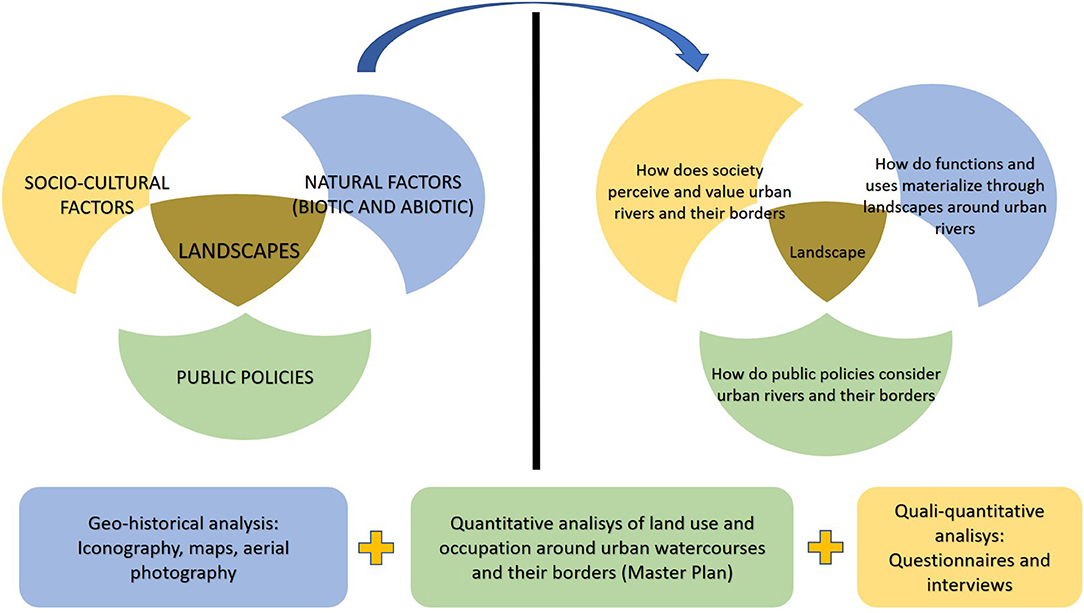
Figure 2. Methodological scheme. Source: Sousa R. B. et al. (2021).
Results
Geo-Historical Analysis of the Landscape Around Watercourses
City Origins
Although there is archaeological evidence of indigenous occupation before the arrival of the pioneers in the region of Lavras (Resende et al., 2010), the confluence of three rivers (Rio Grande, Rio das Mortes and Rio Capivari) and the presence of gold from alluvium in the streams of the region are believed to have been determining conditions for its occupation by the São Paulo pioneers around 1720 (Németh-Torres, 2018). According to reports by French Soldier Millet de Saint-Adolphe, “Several streams and rivers fertilize the district of this new village, which is circumscribed to the north by Rio Grande, and to the south by Rio Verde, tributary of the Sapucaí.” (Saint-Adolphe, 1845, p. 557).
The hydronyms given to watercourses register characteristics identified by the Indians and pioneers at that time: Capivari (capybara river), Ingaí (ingá river), Faisqueira stream [gold ore in granules, “spark”), Grupiara stream (washed gravel)] (Németh-Torres, 2018).
The main gold mine of the village was known as “Real Grandeza” in a place called Tapera (which means “extinct village”) near where it is now the Madeira farm (Costa, 2015), on the banks of Ribeirão Vermelho, formerly called Faisqueira stream, the basin over which the city was developed (Figure 3).
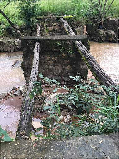
Figure 3. Old bridge crossing the Ribeirão Vermelho in front of the Madeira farm. Source: Sousa R. B. et al. (2021).
Even though there is no precise definition of where the village was first settled, it is believed that the village might have started its development close to the mine situated on Northern region of the city, during the first half of the eighteenth century, expanding along the north-south axis (Németh-Torres, 2018) (Figure 4).
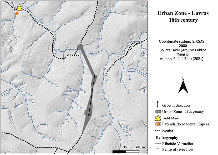
Figure 4. Formation of the urban area of Lavras in the Ribeirão Vermelho basin (eighteenth century). Source: Sousa R. B. et al. (2021).
Mine Depletion and Agricultural Development
Once gold mines in the village were exhausted, the inhabitants resorted to working with agriculture. Therefore, watercourses played an important role moving water mills for cattle breeding, providing irrigation for corn, rice, beans, castor beans, cotton, sugarcane, and tobacco, as well as fruit such as orange, jabuticaba (Myrciaria jaboticaba), pineapple, mango, cambuca (Plinia edulis), among other crops (Németh-Torres, 2018).
Until the end of the nineteenth century, the village did not have running water for basic needs, so the water used in the houses came either from springs and tributaries of the Ribeirão Vermelho, located in thalwegs, or from one of the six wells located in the lower parts of the city (Veiga, 1874). The same author reports that, in the far north of the village, there were sources of iron water, used for medicinal purposes.
From year 1855 on, the local government began to study alternatives to solve the water problem, trying to channel water from another stream in the Southern part of the village (Costa, 2015). Only in 1885 was the service finished, providing drinking water through 29 public and 103 private fountains.
Some of these public taps (Figure 5) were built as fountains, the most famous of which was installed in front of the Mercês church (Delphim, 2020).
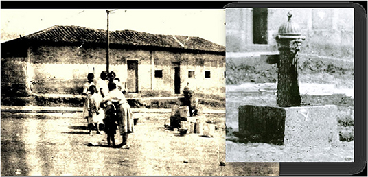
Figure 5. Public fountain installed in 1885 at Praça Dr. Jorge. Source: Renato Libeck's personal archives.
Because only a few families had a private fountain, most of the population would often wash and whiten their clothes in springs, such as Mata Cabrito spring. This spring received this name due to the habit of boys making barbecues of the goats that roamed around there (Delphim, 2020).
From this spring came the Matadouro (Abattoir) Stream, whose hydronym is explained by the presence of an abattoir built by Bernardino Maceira at the end of the nineteenth century (Silva and Paiva, 2008). Intended for the slaughter of animals, it was later transferred to another location due to sanitary reasons. Other cattle-related uses for watercourses and their surroundings have also emerged, including tanneries, silos, watermills, and pestle machines (Németh-Torres, 2018).
At the end of the nineteenth century and the first half of the twentieth century, the Ribeirão Vermelho and its banks received an important railway line connecting the industrial zone in the Northern part of the city to big centers as São Paulo and Rio de Janeiro (Luz et al., 2017). In the Northern area, the first bridges over the watercourse were built due to the great movement in the industrial zone (Figure 6).
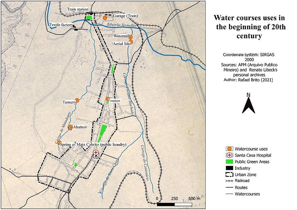
Figure 6. Uses of watercourses and their surroundings until the first half of the twentieth century. Source: Sousa R. B. et al. (2021).
This region usually floods after heavy rains during the summer when water flows down the slopes and joins the tributaries of the Ribeirão Vermelho, damaging the houses in the neighborhood (Lopes and Goes, 2015).
A federal environmental law of 1965 (Law No. 4,771) allowed the occupation of watercourse banks up to a limit of 5 m in distance from the edge of watercourses up to 10 m wide, which may have contributed to the occupation and impermeabilization around rivers in Lavras. In some places, not even the 5-m limit was respected, and some watercourses were gradually obliterated.
New Forest Code and Conflicts of Use and Occupation Around Watercourses
The city of Lavras have been registered several approvals for new subdivisions, which resulted in several interventions in permanent preservation areas around watercourses and springs. This is reflected in the absence of green areas, either due to the lack of inspection or to the lack of accurate data on springs and watercourses (Figure 7). This planning model, aimed at the real estate sector, hardly ever considers water as an integral element of the urban landscape, which is a recurring attitude in other cities in Brazil (Silva-Sánchez and Jacobi, 2012; Fagundes, 2020).
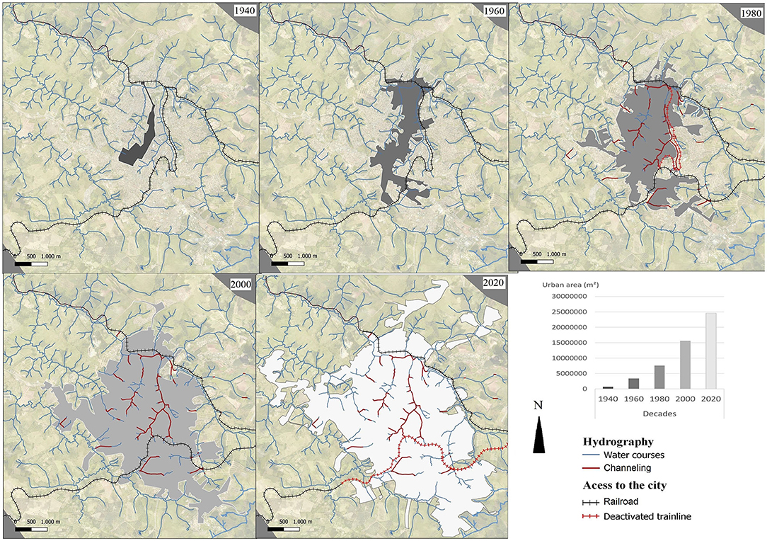
Figure 7. Urban expansion of Lavras and its consequences for watercourses from the second half of the twentieth century to the first decades of twenty-first century. Source: Sousa R. B. et al. (2021).
Since 2012, after the approval of the new Brazilian Forest Code, the local government mitigated this failure by requiring new settlements with at least 10% of the area destined to the green areas, and by demarcating and recovering PPZs for watercourses and springs.
Between 2003 and 2014, the urban area of Lavras grew 28%, and despite the increase in arboreal vegetation in PPZs, soil sealing by buildings also continued to increase (Sousa R. B. et al., 2021).
Currently, 27.74% of the watercourses in the urban zone of Lavras are channeled, either as an open or a closed channel. The remaining 72.26% do not have any infrastructure to access, and have not been used for leisure and contemplation, being largely uncharacterized and often polluted by sewage from illegal constructions on their banks. The surroundings of the streams in the central zone are considered as a consolidated urban area, under the precept that they have lost their natural characteristics, which could be explained by the canalization of watercourses and solid waste management in the areas surrounding them.
Quantitative Analysis of Land Use and Occupation Around Watercourses and Springs (Master Plan)
In order to identify how the land is used and occupied inside the urban PPZs of Lavras, an analysis was carried on august 2019. The urbanized area covered a surface area of 24.27 km2, 4.3% of the municipal territory. Ninety seven springs and 51.80 km of watercourses up to 10 m wide were identified, totaling a legal area of PPZs corresponding to 3.40 km2 within the studied urban perimeter (Figure 8).
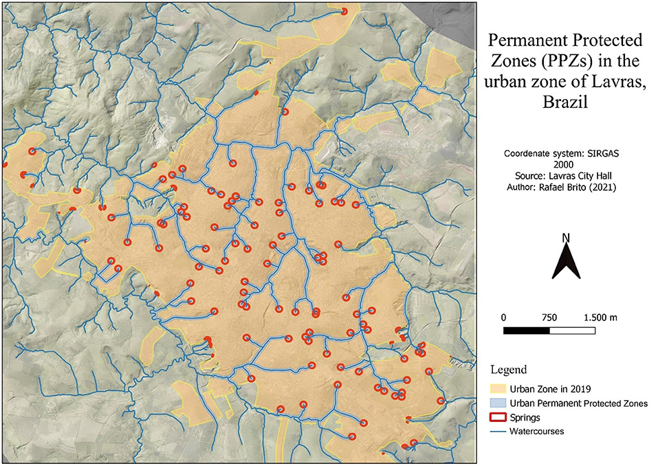
Figure 8. Map of the urbanized perimeter and area referring to the springs and watercourses identified in Lavras-MG. Source: Sousa R. B. et al. (2021).
Within the classes of land use and occupation, 39% of urban PPZs were occupied by arboreal vegetation, while 39% had herbaceous vegetation and/or mineral (permeable) and 22% had built-up zones (impermeable) (Figure 9). Although most of the PPZs of watercourses and springs are still free from buildings, studies demonstrate a tendency of increasing the impermeable zones of some basins within the urban area, harming the natural flow of drainage from the watercourses (Furtini et al., 2007; Sousa R. B. et al., 2021).
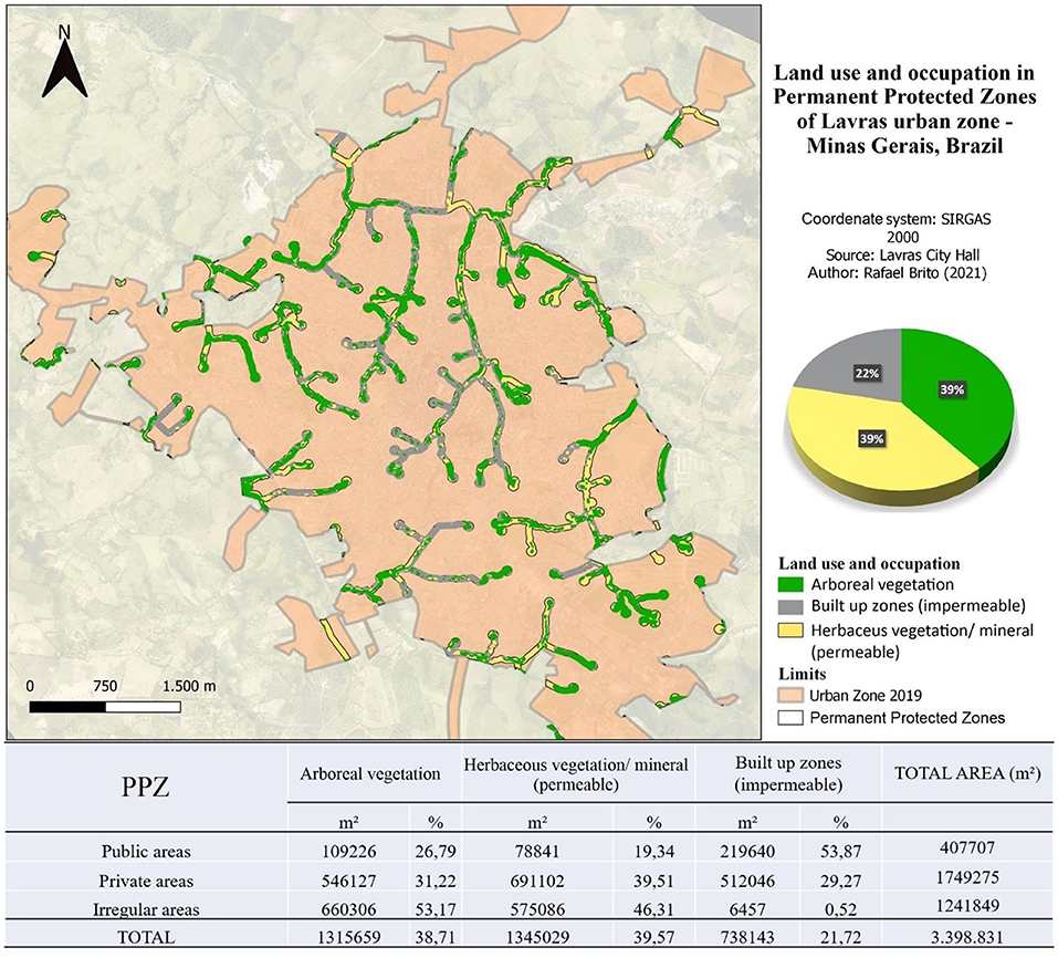
Figure 9. Analysis of land use and occupation in PPZs of springs and watercourses in the urban area of Lavras-MG, in 2019. Source: Sousa R. B. et al. (2021).
The Local Master Plan (PML, 2007) promotes the construction of urban gardens in the section on food security. However, urban land use planning is still underestimating the potential of urban agriculture as a multifunctional nature-based solution (Artmann and Sartison, 2018) which, in addition to providing diverse ecosystem services, contributes to supplying food and neutralizing several other urban challenges (Langemeyer et al., 2021) (Figure 10).
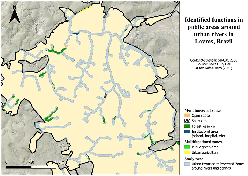
Figure 10. Functions identified in public areas around Lavras watercourses. Source: Sousa R. B. et al. (2021).
According to the Local Master Plan (PML, 2007), to identify possible multifunctional uses provided for in the Urban Zoning of the area under study, there are zones with potential multifunctional uses, such as Special Zone of Historical-Cultural Interest (ZEIHC), Special Zone of Urbanistic-Environmental Interest (ZEIUA), Environmental Protection Zone (ZPA) and Special Zone of Environmental Interest (ZEIA). Nevertheless, there are no specific laws or effective actions for the revitalization or implementation of GBIs or other solutions based on nature (Figure 11).

Figure 11. Urban zoning proposed in the area under study according to the Local Master Plan. Source: Sousa R. B. et al. (2021).
Quali-Quantitative Analysis—Structured Questionnaires and Semi-structured Interviews
According to Berque (1994, p. 17) “society perceives its environment as a function of the changes they make, and they change as a function of the perception they have”. The integration of a river into the city depends on factors such as economy, means of communication and transport, urban expansion projects, public policies, and the behavior of the inhabitants (Coy, 2013). To understand how different segments of society perceive spaces around watercourses and whether there is an idea of multifunctionality, different actors, public, private and civil society were interviewed.
Questionnaires
Out of the 418 respondents, 59.09% were women, 40.66%, men and 0.24% preferred not to identify their gender. The ages of respondents ranged from 18 to over 75 years, being 19.13% between 18 and 25 years, 43.78% between 26 and 40 years, 21.77% between 41 and 60 years, 15.31% over 61 years old, of which only 3% were over 75 years old.
The average income of most respondents was between 1,000 and 3,000 reais (around $180 and $535) per month, which represents 37.32% of the total sample. Among those interviewed, 97.13% resided in Lavras and 2.87% lived elsewhere. Considering the residents of Lavras, most respondents (24.13%) live in the city center.
Respondents were asked to inform which green areas they prefer or most visit to admire nature or to rest. The five green areas most cited were UFLA (76.55%), Praça Dr. Augusto Silva (66.02%), Represa do Funil (47.13%), Parque Quedas do Rio Bonito (36.60%) and Praça Dr. Jorge (25.59%). It is important to highlight that the first 4 cited areas have a water element in the landscape in the form of lakes, rivers, or fountains. The least mentioned ones coincide with the results found by Garcia et al. (2021), consisting of squares without adequate infrastructure, without vegetation and with high impermeabilization. When walking through these places, 69.13% say they pay attention to animals and plants (Figure 12). The experience in nature is the motivation to lead people to attend green areas more often (Salgado et al., 2016).
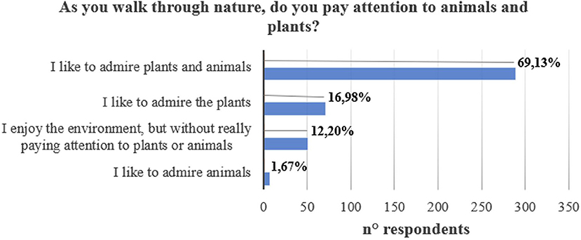
Figure 12. Perception of nature in green areas. Source: Sousa R. B. et al. (2021).
The respondents were asked to identify the three most pleasant environments, according to their own opinion, based on images presented to them. The images were (A) a wooded park, with paths and benches, (B) a fountain surrounded by shrubs and statues, (C) a dam surrounded by vegetation, (D) a straight path with shrubs, (E) a lawn with exposed rocks and vegetation with few leaves, and (F) a small lake surrounded by paths, benches, trees, and a lawn. The highest frequency was indicated for (F) a small lake surrounded by paths, benches, trees and lawn (84.21%), followed by (C) a dam surrounded by vegetation (74.40%), and (A) a wooded park, with paths and benches (74.16%).
Two of the respondents' favorite options included water in different forms in the landscape (Lake, Dam), which may indicate the importance people give to the water element as a component of green spaces. 94.49% of participants confirmed this importance.
When asked which streams in Lavras they knew best, most respondents indicated Ribeirão Vermelho (62.44%), Córrego do Centenário (33.25%) and Ribeirão Água Limpa (30.62%) followed by the Ribeirão Santa Casa (19.61%) and the Ribeirão Matadouro (18.18%).
The main relationship established between respondents and the landscapes of rivers and lakes in the city is for contemplative use (70.09%) (Figure 13). Among respondents who said they do not like rivers, 42.85% justified their choices due to poor water quality, 28.57% thought it was dangerous and 21.42% said they did not have infrastructure.
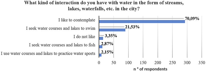
Figure 13. Most common uses for the rivers of Lavras. Source: Sousa R. B. et al. (2021).
In order to understand the uses respondents would expect of these places, the sense revealed that 67.70% of the interviewees suggest the construction of parks and gardens (GBIs), followed by revitalization and protection with restricted access (43.30%) and construction of bike paths (24.40%). The least indicated action was the closing and canalizing rivers (7.17%) (Figure 14).
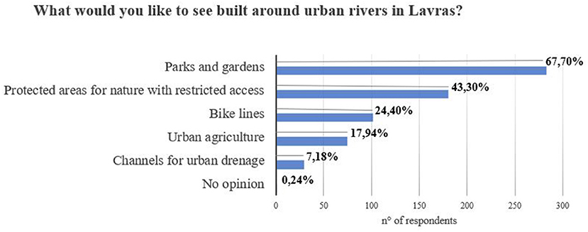
Figure 14. Uses of watercourses desired by the population. Source: Sousa R. B. et al. (2021).
Analyzing the profile of the respondents, considering their contact with the countryside or agriculture, 81.58% have already lived or had a close contact with life in the countryside, compared to 18.42% who neither have nor have had this experience. Also, 22.96% of the respondents have a garden and or a vegetable garden, 22.48% have only a vegetable garden, 14.35% have only a garden, and 40.19% have neither. For those who do not have a garden or a vegetable garden, the reason was lack of space (31.81%).
When asked if they know of shared gardens in Lavras, 38.04% said they do and 61.96% do not. These results may relate to what people would like to see built around urban rivers if they could participate in their management, given that 17.94% of respondents chose to buil urban gardens.
To understand the respondents' habits, the preferred places to buy fruit and vegetables are open-air markets (60.52%), followed by supermarkets (18.66%). Furthermore, to verify the preference for local products, 95.21% would buy local products grown close to their homes.
Interviews
There is a limited participation of civil society in the elaboration of urban policies in Lavras (Andrade and Oliveira, 2019), mostly built by representatives of the economic sector. Thus, to capture the perceptions of Lavras' stakeholders on the issue of watercourses in the city, representatives of the public sector were interviewed, such as the Department of Public Works (Interview 1), a Candidate for Mayor for year 2020 (Interview 2), and a member of Environment office (Interview 3), and from the private sector, a Forestry Engineer of a Construction Company in Lavras (Interview 4).
When asked about the perception of uses and occupations around watercourses, an interviewed from the private sector from Lavras (Interview 4) states that, currently, all areas around rivers and springs must be isolated and protected (PPZs), upon delivery of new allotments:
Nowadays, 100% of the PPZs that are requested from us must be isolated without any possibility of interaction with the population. The current legislation of the municipality of Lavras treats a green area as a square, outside the PPZ. The level of interaction that exists among the population for the environmental use of a green area is a square, which is an interlocked floor, 2, 3, 10 planted (Ipês—Handroanthus albus) and benches, which is practically urbanization. It doesn't offer interaction opportunities as a linear park do, which you can sit on the grass and have a picnic, for example, it's another kind of environmental service (Interview 4).
Among the difficulties encountered in defining uses for these areas, the respondent from the private sector also states that there is great difficulty dialoguing with public stakeholders and environmental councils, especially regarding the definition of concepts such as restoration and green area to be applied:
[...] there is an extremely harmful technical bottleneck... the legislation is flawed, yes, but we find a much greater difficulty in the technical discussion of the councils, in the technical dialogue with secretariats, which today does not exist in Lavras. Restoration has different meaning for each one (Interview 4).
Given the difficulty defining these concepts, even among researchers (Bargos and Matias, 2011), the specification of concepts and techniques is necessary.
Still on the difficulties encountered, now about the management of PPZs by the public sector, the representative of the works department (Interview 1) mentions the reduced staff of the city hall and the difficulty establishing partnerships with universities as limitations.
The city hall does not have a technical body to go “in loco” to check if there is a spring, so the responsibility falls on the Technical Manager of the developer, who tells us that there are no springs, and we are forced to believe. […] I believe that from 2016 onwards, the delay for approval of subdivisions has been greater, as there are several guidelines, and in these, one thing that is very well observed is the preservation of PPZs. Visiting the place and in case of doubts, we leave it to the entrepreneur (Interview 1).
When asking public sector representatives (Interviews 1, 3) about the function of watercourses in the city, it was alleged that some springs preserved in the city still have a certain natural function; however, most watercourses in old settlements are seen only as drainage systems. Furthermore, the importance of specific legislation and a policy to invest in green infrastructure is emphasized:
The urban area is consolidated in many places, but I think that what we could do, when the area does not offer a risk, is something that brings some benefit to the population [...] There could be other leisure and environmental functions if there were one specific legislation and a mayor to invest in it (Interview 1).
Both for the representative from the public sector (Interview 3) and for the representative from the private sector (Interview 4), the law is still not clear about the uses of PPZs in urban areas. When referring to canalized streams, open streams, and consolidated areas, so far, there have been no actions to improve accessibility and interaction between inhabitants and the watercourses in Lavras.
In an interview given to the public during the pre-election period in 2020, candidates expressed their opinion on how the city's flooding problems should be addressed. According to them, the solution would be to invest heavily in rainwater drainage and cleaning of channels to accelerate surface drainage.
We have to invest heavily in rainwater drainage. No mayor likes to do it because it is a work that is done underground, but we did many kilometers of rainwater drainage, it has improved a lot, but if you do not maintain these streams that pass through the city, and remove weeds and stones from the path when the rainy season starts, we will have floods.[...] There are still some channels to close, some galleries, but today the Local Environment Department prefers to maintain the channel open (Interview 2).
Discussion
Urban Expansion and the Canalization of Watercourses
In the 1980s, Lavras received an Urban Complementation Plan, financed by program CURA (Comunidade Urbana de Recuperação Acelerada—Urban Community for Accelerated Recovery). One of the main goals of CURA was to occupy idle land, increasing urban density, which, according to Mascaró (1989), should reduce urbanization costs. In addition to canalizing watercourse banks, the program directed most of its resources to paving streets and building rainwater drains, to accelerate the occupation of open spaces (Franco, 2014), such as the valleys.
Following the hygienist model, the urban drainage system aimed at collecting and keeping rainwater away (Silveira, 2018). This model remained in Brazilian cities until the end of the twentieth century. In 1986, a new law (Law No. 7.511/1986) changed the Brazilian Forest Code, extending the protection limits of watercourses to 30 m (for streams up to 10 m wide) and a 50-m radius around springs, which led to conflicts that persist nowadays.
Studies carried out by Furtini et al. (2007) indicated an increase in impermeable zones on the stream borders due to the urbanization process. With the increasing degradation of the city's watercourses, a Master Plan was passed in 2007, providing for recovery and qualification actions for landscaping and urban treatment of the valley of the Centenário/Santa Casa and Matadouro streams, as well as the Ribeirão Vermelho and Água Limpa, including the implementation of green areas for leisure where possible (PML, 2007). However, until 2019, these areas were yet to receive any landscaping and urban treatment.
According to Bueno (2006), in Brazil, new ventures insist on following old engineering and urbanism practices, obtaining environmental licenses to fill springs and floodplains, channel streams, thus creating large impermeable areas. This paradigm prevailed for decades in the urbanization plans of several cities, eliminating watercourses from the urban landscape, since they are considered “a health hazard” (Reynoso, 2010).
Urban Land Regularization and the Multifunctionality Proposal
As a result, many of the areas surrounding watercourses and springs are undergoing a land regularization process, through the Urban Land Regularization Program (Reurb). Article 9, paragraph 1 of the new law (Law no. 13,465, of 2017) provides for the multifunctional use of these areas:
“Public authorities shall formulate and develop policies for their competences in the urban space according to the principles of economic, social, and environmental sustainability and territorial ordering, seeking to occupy the land in an efficient manner, combining its uses in a functional way” (BRASIL, 2017).
Although the legislation provides for land occupation that combines uses in a functional way, the law is not clear about the use of the same territory for different simultaneous functions, which can raise questions about how stakeholders should behave, leading to fragmentation and discontinuity of the landscape along watercourses. Combining different land uses on the same terrain seems to be the best way to protect ecosystem services, and further enhance the value of open spaces in cities (IAU, 2011).
Quantitative Analysis of Land Use and Occupation Around Watercourses and Springs (Master Plan)
Riparian vegetation is important for the maintenance of hydrographic basins, as it promotes the containment of erosions in the form of gullies, that are common in the urban area of Lavras (Pinto et al., 2004; Furtini et al., 2007; Guimarães et al., 2012). It also contributes to the maintenance of biodiversity in urban areas (Moura et al., 2010; Lombardi et al., 2012; Lopes and Peixoto, 2018; Cruz and Pompeu, 2020).
The presence of arboreal and shrubby vegetation is also an important factor to be considered for the implementation of public green areas, since it plays ecological, scenic, and recreational functions. Furthermore, this type of vegetation improves the aesthetic, functional and environmental quality of the city, being endowed with vegetation and spaces free from waterproofing (CONAMA, 2006).
Lavras has a low green area index, GAI = 0.62m2/inhabitant (Garcia et al., 2021), considering that the minimum recommended value is 15 m2/inhabitant (SBAU, 1996). The city also has a low green space ratio (0.29%), and a disproportional distribution of green areas, with GAI close or equal to zero in the peripheral sectors, normally inhabited by low-income population (Garcia et al., 2021).
Bolund and Hunhammar (1999) highlight how low-income settlements lack access to urban green spaces (UGS), and tend to be in undesirable and environmentally problematic areas (Simon, 2010; Meirelles Filho and Miranda, 2016). These areas often coincide with surrounding watercourses, subject to flooding and receiving diffuse pollution from urban drainage (Roy et al., 2018). This fact reinforces the need to transform these spaces into green areas and urban gardens (green and blue infrastructure), which perform not only natural, but also economic and social functions such as income increase, leisure, entertainment, and socialization. (Araújo et al., 2016).
The idea of multifunctionality in green and blue infrastructure planning means the intentional combination of ecological, social, and economic functions, not only products of chance (Hansen and Pauleit, 2014). In Lavras, this does not happen, considering that many areas around watercourses and springs do not have structures that allow access to recreational or educational use by the population, and, therefore, are not considered in the city's green area index.
Analyzing the public areas in urban PPZs of Lavras, there are forest fragments without public access, sports spaces and institutional areas with little or no vegetation and permeability, and free spaces subject to invasion and solid waste management.
A multifunctional alternative that has worked in several cities is the implementation of urban gardens in open spaces adjacent to PPZs. Around 40% of the inhabitants who answered the questionnaire do not have gardens at home, mostly due to lack of space.
As an example, the housing project in Lavras brought multifunctionality to an area, previously used for solid waste management, through the construction of an urban community garden (Araújo et al., 2016). Although other urban gardens have already been implemented in Lavras, this is the only one that currently remains active.
Considering that one of the hypotheses of the city's origin was related to the exploitation of alluvial gold, as suggested by the city's name, the city's streams should be viewed as a natural site to be protected. However, according to the Lavras Cultural Collection Protection Inventory (PML, 2019), there is still no protected natural site in the municipality, other than a tree (Tipuana tipu) in the city's main square.
Although the revitalization and construction of green areas along the watercourses have been sanctioned for more than 10 years in the Master Plan (PML, 2007), solutions that contribute to that have not yet been implemented. Moreover, it is known that revitalizing watercourses is fundamental for benefiting ecosystem services, and not only for being used as draining and transporting sewage, residues, and flood waters (Selles et al., 2001).
For Coy (2013), the explanations may differ depending on each specific case, the political-institutional framework of the place, power relations, the interests of possible investors, among other factors. In Campinas/SP, Brazil, the Ribeirão das Pedras Linear Park is a successful example of the implementation of green-blue infrastructure for the revitalization of watercourses (Foloni and Constantino, 2016). Other ongoing projects indicate the importance of public-private partnerships and the consideration of river basins and sub-basins for the urban zoning present in local master plans (Foloni and Constantino, 2016).
According to the City Statute for Brazil (BRASIL, 2001), the elaboration and implementation of Master Plans must occur with the participation of all segments of society. They should also define impacts on the various environmental, social, and economic areas, favoring the multifunctional use of areas susceptible to geological and hydrological processes, as well as new expansion areas.
Quali-Quantitative Analysis—Structured Questionnaires and Semi-structured Interviews
From the results obtained with the questionnaires, it is worth pointing out that, as shown in the analysis of land use and occupation, most of the uses determined in the urban zoning of the study area do not allow a simultaneous use of different functions such as, nature preservation, leisure, economic activities, which does not contribute to integration of rivers into the city. According to Soga et al. (2015), people who live close to multifunctional areas, such as green areas, use them more often.
The largely contemplate use can be explained by the poor quality and accessibility of these spaces declared by 64.83% of respondents. In a small proportion, 16.51% believe access to rivers is easy but poor in quality, 11.72% of respondents consider them inaccessible, but of good quality. Only 5.02% were satisfied with the quality of and accessibility to river landscapes and 1.91% did not have an opinion (Figure 15).
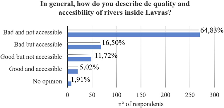
Figure 15. Opinion on quality of and accessibility to streams of Lavras. Source: Sousa R. B. et al. (2021).
Despite the poor quality and difficult access to spaces around the rivers, the population values water as an important element in the composition of green spaces. In other words, the conditions in which these spaces are do not meet the population's expectations in relation to the water element in the city.
According to Jim (2013), watercourses provide an important landscape element for the development of green and blue infrastructure, as people's affinity for the water element can increase the appeal of public green areas and, thus, help to revitalize or preserve natural waterways that run through cities. In addition, some areas around watercourses in Lavras have been used to encourage urban agriculture through community gardens (Araújo et al., 2016). Society has been looking for a sustainable lifestyle, and these challenges need to be faced by a diverse ecosystem of private actors, universities, civil society, and politicians (Baccarne et al., 2016).
Interviews
Although the public sector in several cities has already realized the potential of the areas surrounding watercourses for carrying out works of common interest, to improve the city's image and its attractiveness for high quality investments (Coy, 2013; Lotfi et al., 2017), multifunctional solutions, such as public green areas and other green infrastructures, have not yet been used in the city of Lavras.
On the other hand, Cengiz (2013) and other authors recommend avoiding rigid artificial systems, but rather installing natural landscapes, as they make it possible to restore the natural functions of watercourses, filter pollutants, prevent erosion of the banks and the canalization of the stream's bed.
In this context, watercourses and their geomorphologies form “landscape systems” that should comprise all types of management involving the landscape. In different scales, landscape systems have unique elements, with the potential to exert changes to contribute to the lost balance between man and nature in urban centers (Hoyuela Jayo, 2017).
There is a limitation in the legislation that does not emphasize exactly what must be done and confirmed by an actor's opinion (“the legislation is flawed”, Eng. Forestier—real state agency CAP). Thus the coverage of watercourses ends up being allowed. An important point to be consider is the necessity to know and connect the desires of the population with the decisions to be made by public actors. Observing the results on Figure 14, are indicated that these desires are true. Only 7.18% indicated that the water courses should be used as channels for urban drainage, which is the mainly current use. Most indicated the desire to build green areas, besides leisure and conservation spaces, constituting a multifunctional system.
Concerning the interviewers opinion, there are some the difficulties encountered in defining uses for public areas, and there is great difficulty dialoguing with the public actors and environmental councils. Also, they highlighted the importance of developing a specific legislation and a policy to invest in green infrastructure.
In this way, the importance of the green and blue infrastructure in recognized both population and public actors, demanding connections and join decisions to preserve and also create areas.
Conclusions
Through the geo-historical analysis, it was possible to observe that after the 1980s, the watercourses present in the consolidated areas in the center of Lavras underwent major changes, undermining their natural, social, and economic functions, but maintaining only their drainage functions. From the implementation of the new Brazilian Forest Code in 2012, the areas in expansion prioritize the preservation of the natural function, but lack the incentive to implement the other functions such as social and economic.
Despite current legislation providing for the multifunctional use of watercourses and their surroundings, many have a predominance of one function over the others. Others are monofunctional and do not contribute to reintegrating watercourses into the urban landscape of Lavras or to improving the population's quality of life.
Public and private actors recognize the lack of clarity and specificity of current legislation, regarding the possible uses of these urban spaces. The government has not yet managed to implement green and blue infrastructures (GBIs) to reconcile the natural, social, and economic functions of streams and creeks, but still allows the use of techniques for sealing soils and canalizing watercourses.
Lavras does not have an established blue infrastructure, considering that the existing watercourses are not used by the population with social and economic functions. The lack of information about these spaces and the difficult access to them contribute to the lack of clarity in the lagislation. Participatory approach and transdisciplinary processes could help stakeholders and sensitize the population to the importance of urban rivers and their multifunctional role.
The methodology used and the positive results, indicate that this study may be replicated in any city and may help local managers to plan strategies for green and blue infrastructure concerning the area evolution and population aims. Also, this work can also be used as a study case that reflects the interaction of urbanization in Brazil associated with watercourses that cross the urban area.
Data Availability Statement
The raw data supporting the conclusions of this article will be made available by the authors, without undue reservation.
Author Contributions
RS: project development, methodology, data collection, statistical analysis, and writing original draft. PP: methodology, project development, and writing review and editing. MR and NC: methodology, project development, and writing review. All authors contributed to the article and approved the submitted version.
Funding
This work was carried out with the support of the Coordination for the Improvement of Higher Education Personnel-Brazil (CAPES), the National Council for Scientific and Technological Development (CNPq), the Minas Gerais Research Support Foundation (FAPEMIG), the laboratory UMR (6590) ESOAngers, and the University of Angers (UA).
Conflict of Interest
The authors declare that the research was conducted in the absence of any commercial or financial relationships that could be construed as a potential conflict of interest.
Publisher's Note
All claims expressed in this article are solely those of the authors and do not necessarily represent those of their affiliated organizations, or those of the publisher, the editors and the reviewers. Any product that may be evaluated in this article, or claim that may be made by its manufacturer, is not guaranteed or endorsed by the publisher.
Acknowledgments
We are very thankful to the municipality of Lavras and public actors, for opening and exchanging information. Also we acknowledge the Graduate Program in Plant Science of the Universidade Federal de Lavras for providing de Doctorate Sandwich Program and Cotutele MoU.
Supplementary Material
The Supplementary Material for this article can be found online at: https://www.frontiersin.org/articles/10.3389/frsc.2022.793288/full#supplementary-material
References
Ahern, J. (1995). Greenways as a planning strategy. Landscape Urban Plan, 33:1–3, 131–155. doi: 10.1016/0169-2046(95)02039-V
Alves, S. F. N. S. C., Sousa, R. B., and Paiva, P. D. O. (2017). História da Praça Severiano Rezende—o Largo do Tamandaré em São João del-Rei. Lavras: Editora UFLA.
Andrade, L. F. S., and Oliveira, M. L. S. (2019). Distâncias e Relações entre Sociedade Civil e Poder Público Local: Atuação de duas Associações de Moradores em Lavras, MG. Administração Pública e Gestão Social. 11, 2. doi: 10.21118/apgs.v11i2.5373
Antrop, M., and Van Eetvelde, V. (2000). Holistic aspects of suburban landscapes: visual image interpretation and landscape metrics. Landscape Urban Plan. 50, 1, 43–58. doi: 10.1016/S0169-2046(00)00079-7
APM—Arquivo Público Mineiro (2021). Available online at: http://www.siaapm.cultura.mg.gov.br/ (accessed on January 18, 2021).
Araújo, H. M., Assis, T. R. P., and Martins, A. P. B. (2016). Agricultura urbana e segurança alimentar: estudo de caso da horta comunitária da COHAB em Lavras/MG. Cad. Agroecol. 10, 3.
Artmann, M., and Sartison, K. (2018). The role of urban agriculture as a nature-based solution: a review for developing a systemic assessment framework. Sustain. 10:6, 1937. doi: 10.3390/su10061937
Baccarne, B., Logghe, S., Schuurman, D., and Marez, L. (2016). Governing quintuple helix innovation: urban living labs and socio-ecological entrepreneurship. Tech. Innov. Manag. Rev. 6:3, 22–30. doi: 10.22215/timreview/972
Baptista, M. B., and Cardoso, A. S. (2013). Rios e cidades: uma longa e sinuosa história. Rev. Univ. Fed. M. Gerais, 20:2, 124–153. doi: 10.35699/2316-770X.2013.2693
Bargos, D. C., and Matias, L. F. (2011). Áreas verdes urbanas: um estudo de revisão e proposta conceitual. Rev. Soc. Bras. Arb. Urbana. 6, 172–188. doi: 10.5380/revsbau.v6i3.66481
Boldrin, K. V. F., Garcia, C. S. G., Paiva, P. D. O., and Carvalho, L. M. (2016). Quantitative inventory and analysis of the green areas in Lavras-MG and index evolution. Ornam. Hortic. 22, 138–142. doi: 10.14295/oh.v22i2.769
Bolund, P., and Hunhammar, S. (1999). Ecosystem services in urban areas. Ecol Econ. 29, 293–301. doi: 10.1016/S0921-8009(99)00013-0
BRASIL (1966). Lei n° 5.172, de 25 de outubro de 1966. Available online at: http://www.planalto.gov.br/ccivil_03/leis/l5172.htm (accessed on February 20, 2019).
BRASIL (2001). Lei n. 10.257, de 10 de julho de 2001. Available online at: http://www.planalto.gov.br (accessed April 26, 2020).
BRASIL (2012). Lei n. 12.651, de 25 de maio de 2012. Available online at: http://www.planalto.gov.br/ccivil_03/_ato2011-2014/2012/lei/l12651.htm (accessed April 7, 2019).
BRASIL (2017). Lei n. 13.465, de 2017. Dispõe sobre a regularização fundiária rural e urbana. Available online at: http://www.planalto.gov.br/ccivil_03/_ato2015-2018/2017/lei/l13465.htm (accessed on January 7, 2020).
Bueno, L. M. M. (2006). Faixas marginais aos rios urbanos: o que fazer? Oculum Ensaios. Rev. Arq. Urb. 6, 9.
Carvalho, L. M. T., and Scolforo, J. R. (2008). Inventário Florestal de Minas Gerais: Monitoramento da flora nativa 2005-2007. Lavras: Editora UFLA.
Cengiz, B. (2013). Urban river landscapes. In: Advances in Landscape Architecture. UK: IntechOpen. doi: 10.5772/56156
Clergeau, P. (2012). Services écologiques et Trame Verte Urbaine. Note de recherche. Vertigo-la revue électronique en sciences de l'environnement, n. Hors-série. 12. doi: 10.4000/vertigo.11834
CONAMA (2006). Conselho Nacional do Meio Ambiente. Resolução n° 369, de 28 de março de 2006. (accessed on January 17, 2020).
Cormier, L., De Lajartre, A. B., and Carcaud, N. (2010). La planification des trames vertes, du global au local: réalités et limites. Cybergeo Eur. J. Geogr. Aménagement, Urbanisme. 504, 1–33. doi: 10.4000/cybergeo.23187
Costa, F. (2015). Vida Escolar de Firmino Costa (1907-1908); organização e notas por Geovani Németh-Torres. Lavras, MG; Geovani Németh-Torres.
Coutts, C., and Hahn, M. G. (2015). Infrastructure, Ecosystem Services, and Human Health. Int. J. Environ. Res. Pub. Health. 12, 8. doi: 10.3390/ijerph120809768
Coy, M. (2013). A interação rio-cidade e a revitalização urbana: experiências europeias e perspectivas para a América Latina. Confins. Rev. Franco-Brés Géog. 18. doi: 10.4000/confins.8384
Cruz, L. C., and Pompeu, P. S. (2020). Drivers of fish assemblage structures in a Neotropical urban watershed. Urb. Ecosys. 23, 819–829. doi: 10.1007/s11252-020-00968-6
Dantas, A. A. A., Carvalho, L. G., and Ferreira, E. (2007). Classificação e tendências climáticas em Lavras, MG. Ci Agrotec. 31:6, 1862–1866. doi: 10.1590/S1413-70542007000600039
De Groot, R. S., Wilson, M. A., and Boumans, R. M. J. (2002). A typology for the classification, description and valuation of ecosystem functions, goods and services. Ecolog Econ. 41:3, 393–408. doi: 10.1016/S0921-8009(02)00089-7
Everard, M., and Moggridge, H. L. (2012). Rediscovering the Value of Urban Rivers. Urb Ecosys, 15, 293–314. doi: 10.1007/s11252-011-0174-7
Fagundes, B. (2020). Rios urbanos e a política de canalização. Soc Nat. 32, 416–425. doi: 10.14393/SN-v32-2020-44991
Foloni, F. M., and Constantino, N. R. T. (2016). Reconciliando rios urbanos com a paisagem: levantamento de estudos de caso. Rev Nac Gerenciam Cid, 4, 23. doi: 10.17271/2318847242320161309
Franco, R. M. (2014). As políticas habitacionais e as mudanças na paisagem urbana de Londrina. Geog. Opport Temp, 1:2, 32–50.
Furtini, M. B., Ferreira, E., and Sampaio, F. M. T. (2007). Análise temporal da permeabilidade da superfície urbana da sub-bacia do córrego centenário em Lavras, MG. Ci Agrotec. 31, 1145–1154. doi: 10.1590/S1413-70542007000400030
Garcia, C. S. G., Alves, S. F. N. S. C., and Paiva, P. D. O. (2011). História do jardim da avenida Tancredo Neves—a praia de São João del-Rey. Lavras: Editora UFLA.
Garcia, C. S. G., Paiva, P. D. O., Bruck, J., and Sousa, R. B. (2021). Distribution of urban green spaces: Comparative analysis between cities in different countries. Ornam. Hortic., 27, 8–19. doi: 10.1590/2447-536x.v27i1.2151
Guimarães, J. C. C., Almeida, W., Pais, P., and Andrade, M. L. (2012). Abordagem de práticas conservacionistas na recuperação de voçorocas. Encicl. Bios, 8, 14.
Hansen, R., and Pauleit, S. (2014). From multifunctionality to multiple ecosystem services? A conceptual framework for multifunctionality in green infrastructure planning for urban areas. Ambio, 43, 516–529. doi: 10.1007/s13280-014-0510-2
Hervieu, B. (2002). La multifonctionnalité de l'agriculture: genèse et fondements d'une nouvelle approche conceptuelle de l'activité agricole. Cahiers Agricult, 11, 415–419.
Hoyuela Jayo, J. A. (2017). A paisagem como instrumento para um planejamento sustentável: uma visão dialética entre Europa e o Brasil. In. Oliveira M.L, Custódio M.M, Lima C.C (org.), Direito e paisagem: a afirmação de um direito fundamental individual e difuso. Belo Horizonte: Editora D'Plácido.
IAU (2011). Institut d'Aménagement et d'Urbanisme—Île de France. La multifonctionnalité des trames verte et bleue en zones urbaines et périurbaines. Synthèse bibliographique.
IBGE (2018). Instituto Brasileiro de Geografia e Estatística. Available online at: www.ibge.gov (accessed on February 21, 2018).
IPCC—Intergovernmental Panel on Climate Change (2013). Cambridge, United Kingdom and New York: Cambridge University Press.
Jim, C. Y. (2013). Sustainable urban greening strategies for compact cities in developing and developed economies. Urb Ecosys. 16, 741–761. doi: 10.1007/s11252-012-0268-x
Kato, S., and Ahern, J. (2009). Multifunctional landscapes as a basis for sustainable landscape development. J. Jpn. Inst. Landscape Arch. 72, 799–804. doi: 10.5632/jila.72.799
Kim, G., and Coseo, P. (2018). Urban park systems to support sustainability: the role of urban park systems in hot arid urban climates. Forests. 9, 7. 439. doi: 10.3390/f9070439
Lamond, J., and Everett, G. (2019). Sustainable Blue-Green Infrastructure: a social practice approach to understanding community preferences and stewardship. Landscape Urban Plan. 191, 103639. doi: 10.1016/j.landurbplan.2019.103639
Langemeyer, J. (2021). Urban agriculture—a necessary pathway towards urban resilience and global sustainability?. Landscape Urban Plan. 210, 104055. doi: 10.1016/j.landurbplan.2021.104055
Laugier, R. (2010). Trame verte et bleue, Synthèse documentaire établie par Robert Laugier pour le compte du Centre de Ressources Documentaires Aménagement Logement Nature (CRDALN). Available online at: http://www.paysagistes-conseils.org/sites/apce/files/contenus/tramevertebleue.pdf (accessed October 10, 2020).
Lombardi, V. T., Santos, K. K., Neto, S. A., Mazzoni, L. G., Renno, B., Faetti, R. G., et al. (2012). Registros notáveis de aves para o sul do estado de Minas Gerais, Brasil. Cotinga. 34, 32–45.
Lopes, L. E., and Peixoto, H. J. C. (2018). Aves campestres ameaçadas de extinção encontradas nos Campos do Alto Rio Grande, sul de Minas Gerais: notas sobre sua história natural e proposições para estudos futuros. Atualidades Ornitológicas. p. 201. Available online at: http://www.ao.com.br/download/AO201_40.pdf (accessed October 21, 2020).
Lopes, N. D., and Goes, H. (2015). Ação emergencial para reconhecimento de áreas de alto e muito alto risco a movimentos de massa e enchentes: Lavras, MG. CPRM.
Lotfi, M. (2017). Les services écosystémiques urbains, vers une multifonctionnalité des espaces verts publics: revue de littérature. Environ Urb. 11. doi: 10.7202/1050485ar
Luz, I. C. A., Paiva, P. D. O., and Alves, S. F. N. S. C. (2017). Train station area gardens: the creation and evolution of Dr. José Esteves Square, in Lavras-MG. Ornam. Hortic. 23, 432–443. doi: 10.14295/oh.v23i4.1117
Martines, M. R., Cavagis, A. D.M., Kawakubo, F. S., Morato, R. G., Ferreira, R. V., Toppa, R. H., et al. (2020). Spatial segregation in floodplain: an approach to correlate physical and human dimensions for urban planning. Cities. 97, 102551. doi: 10.1016/j.cities.2019.102551
Martins, G. A., and Theóphilo, C. R. M. (2009). investigação científica para Ciências Sociais Aplicadas. São Paulo: Atlas.
McDonald, R. I. (2009). Ecosystem service demand and supply along the urban-to-rural gradient. J Conserv Plann. 5, 1–14.
Meirelles Filho, J., and Miranda, E. E. (2016). Rios do Brasil. História e cultura. São Paulo: Metalivros.
Moreira, F. S. A., and Vitorino, M. I. (2019). Elementos para uma sustentabilidade urbana e ambiental em Belém, Pará: um ensaio da trama verde e azul. Rev. Gest Sustentab Amb. 8, 264–279. doi: 10.19177/rgsa.v8e22019264-279
Moura, A. S., Corrêa, B. S., and Abranches, C. T. S. (2010). Distribuição da avifauna em um fragmento de mata nativa em área urbana no município de Lavras, Sul de Minas Gerais. Rev Agrogeoamb, 2, 9–21. doi: 10.18406/2316-1817v2n22010268
Paiva, P. D. O., Sousa, R. B., and Alves, S. F. N. S. C. (2021). Patchwork quilt: a methodology proposed for the study of historic gardens. Urb. Forest. Urb. Green. 62, 127169. doi: 10.1016/j.ufug.2021.127169
Pinto, L. V. A., Botelho, S. A., Oliveira-Filho, A. T., and Davide, A. C. (2004) Estudo das nascentes da bacia hidrográfica do Ribeirão Santa Cruz, Lavras, MG. Sci Forest, 65, 197–206.
PML (2007). Prefeitura Municipal de Lavras—Lei complementar n° 097, de 17 de abril de 2007. Available online at: http://www.lavras.mg.gov.br (accessed on February 2018).
PML (2019). Prefeitura Municipal de Lavras—Inventário de Proteção ao Acervo Cultural de Lavras. Available online at: http://www.ipatrimonio.org/wp-content/uploads/2018/10/Lista-de-bens-da-Prefeitura-Municipal-de-Lavras-MG.pdf (accessed June 2, 2019).
QGIS Development Team (2017). Quantum GIS Geographical Information System v3.16.1. Open Source Geospatial Foundation project. Available online at: http://qgis.osgeo.org (accessed May 8, 2017).
R Core Team (2016). R: A Language and Environment for Statistical Computing. R Foundation for Statistical Computing, Vienna, Austria. Available online at: https://www.R-project.org/ (accessed May 15, 2021).
Reis, A. A., Teixeira, M. D., Junior, F. W. A., Melo, J. M., Leite, L. R., and Silva, S. T. (2012). Land use and occupation analysis of Permanent Preservation Areas in Lavras County, MG. Ciência e Agrotecnologia. 36, 300–308. doi: 10.1590/S1413-70542012000300005
Resende, M. L. C., Sales, C. L., and Rocha, L. C. B. M. (2010.) Mapeamento da arte rupestre na Estrada Real. Rev. Arq. Púb. Mineiro 109–125. Available online at: https://www.researchgate.net/publication/231537223_Mapeamento_da_arte_rupestre_na_Estrada_Real/stats (accessed May 26, 2021).
Reynoso, A. E. G. (2010). Teorías e métodos para la restauración de ríos. In: Rescate de ríos urbanos. Propuestas conceptuales y metodológicas para la restauración y rehabilitaciónde ríos. Universidad Nacional Autonóma de México. Coordinación de Humanidades. Programa Universitario de Estudios sobre la Ciudad. México.
Rezende, G. B. M., and Araújo, S. M. S. (2016). As Cidades e as Águas: ocupações urbanas nas margens de rios. Rev. Geog. 33, 2.
Roy, M. (2018). Climate change and declining levels of green structures: Life in informal settlements of Dar es Salaam, Tanzania. Landscape Urban Plan. 180, 282–293. doi: 10.1016/j.landurbplan.2017.11.011
Saint-Adolphe, J. C. R. M. (1845). Diccionario Geographico, Historico e Descriptivo, do Imperio do Brazil. Paris: J. P. Aillaud, tomo I. p. 556–557.
Salgado, M. C. R., Figueiredo, P. H. F., Boldrin, K. V. F., Sousa, R. B., and Paiva, P. D. O. (2016). Parque ecológico Quedas do Rio Bonito: percepções da frequência de visita. Ornam. Hortic., 22, 172–179. doi: 10.14295/oh.v22i2.894
SBAU—Sociedade Brasileira de Arborização Urbana (1996). Carta a Londrina e Ibiporã. Boletim Informativo. 3, 3.
Selles, I. M., Vargas, A. V., Riker, F., Bahiense, G., Rios, J. P., Cunha, L., et al. (2001). Revitalização de rios—orientação técnica. Rio de Janeiro: SEMADS, 11, 78.
Selmi, W., Weber, C., and Mehdi, L. (2013). Multifonctionnalité des espaces végétalisés urbains. VertigO: la revue électronique en sciences de l'environnement. 13, 2. doi: 10.4000/vertigo.14133
Silva, A. T., and Paiva, P. D. O. (2008). Do Romantismo à Atualidade: Lavras, história de uma praça. Lavras; UFLA.
Silva-Sánchez, S., and Jacobi, P. R. (2012). Políticas de recuperação de rios urbanos na cidade de São Paulo. Possibilidades e desafios. Rev. Bras. Est. Urb. Reg. 14, 119–132. doi: 10.22296/2317-1529.2012v14n2p119
Silveira, A. L. L. (2018). Trama verde-azul e drenagem urbana sustentável. Planejamento e gestão territorial: a sustentabilidade dos ecossistemas urbanos. Criciúma: EDIUNESC.
Simon, D. (2010). The challenges of global environmental change for urban Africa. In: Urban Forum. Netherlands: Springer. doi: 10.1007/s12132-010-9093-6
Soga, M. (2015) Reducing the extinction of experience: Association between urban form and recreational use of public greenspace. Landscape Urban Plan. 143, 69–75. doi: 10.1016/j.landurbplan.2015.06.003
Sousa, R. B., Paiva, P. D. O., and Carcaud, N. (2021). Análise diacrônica de uso e ocupação do solo em áreas de preservação permanentes (APPs) ao longo de rios urbanos. In: Fidalgo, P. (org) Dinâmicas da paisagem:entre a realidade e o desejo. Lisboa: HTC—História, Territórios, Comunidades.
Teixeira, R. L. P., and Pessoa, Z. S. (2020). Mudanças climáticas, experimentação de políticas públicas e capacidade adaptativa na cidade de curitiba/pr-brasil. Rev. Inter-Legere, 3, 27. c18712-c18712.
Wiggering, H., Dalchow, C., Glemnitz, M., Helming, K., Müller, K., Schultz, A., et al. (2006). Indicators for multifunctional land use—Linking socio-economic requirements with landscape potentials. Ecol Indic. 6, 238–249. doi: 10.1016/j.ecolind.2005.08.014
Yeakley, J. A., Ervin, D., Granek, E. F., Dujon, V., Shandas, V., and Brown, D. (2016). Ecosystem services of streams and rivers. In: Gilvear D., Greenwood M., Thoms M., Wood P, editors. River Science: Research and Management for the 21st Century. Wiley-Blackwell, Chichester.
Zinia, N. J., and Mcshane, P. (2018). Ecosystem services management: An evaluation of green adaptations for urban development in Dhaka, Bangladesh. Landscape Urban Plan. 173, 23–32. doi: 10.1016/j.landurbplan.2018.01.008
Interviews
Interview 1 | Member of Department of Public Works. Lavras, Oct 26, 2020. Interview recorded by Rafael de Brito Sousa.
Interview 2 | Candidate for Mayor for year 2020. Nov 03, 2020. Public Interview registered in Instagram (Direct Messenger).
Interview 3 | Member of Department of Environment. Feb 10, 2021. Interview recorded by Rafael de Brito Sousa.
Interview 4 | Forestry Engineer from a Construction Company from Lavras. Lavras, Mar 23, 2021. Interview recorded by Rafael de Brito Sousa.
Keywords: urban rivers, sustainable cities, green and blue infrastructure, green areas, multifunctionality
Citation: Sousa RB, Paiva PDO, Reis MV and Carcaud N (2022) The Trajectory of the Landscape and Functionality of Urban Watercourses: A Study of Lavras City, Brazil. Front. Sustain. Cities 4:793288. doi: 10.3389/frsc.2022.793288
Received: 11 October 2021; Accepted: 18 May 2022;
Published: 23 June 2022.
Edited by:
Francisco De La Barrera, University of Concepcion, ChileReviewed by:
Mohammad Reza Masnavi, University of Tehran, IranVivian Loges, Federal Rural University of Pernambuco, Brazil
Copyright © 2022 Sousa, Paiva, Reis and Carcaud. This is an open-access article distributed under the terms of the Creative Commons Attribution License (CC BY). The use, distribution or reproduction in other forums is permitted, provided the original author(s) and the copyright owner(s) are credited and that the original publication in this journal is cited, in accordance with accepted academic practice. No use, distribution or reproduction is permitted which does not comply with these terms.
*Correspondence: Patrícia Duarte de Oliveira Paiva, patriciapaiva@ufla.br