Interlinkages and gaps: a review of the literature on intergovernmental relations for flood management in the face of climate change
 Alexander Chantilas1
  Ahmed Rachid El-Khattabi2
  Emily Gvino1,3
  Kristen Downs2 Cate Byrne1 Elizabeth Christenson-Diver1 Ranger Ruffins1 Aaron Worley1 Felix Dodds1*
- 1Water Institute, Gillings School of Public Health, University of North Carolina at Chapel Hill, Chapel Hill, NC, United States
- 2Environmental Finance Center, School of Government, University of North Carolina at Chapel Hill, Chapel Hill, NC, United States
- 3Clarion Associates, Chapel Hill, NC, United States
Current approaches to flood management are increasingly insufficient to deal with intensifying flood trends. In this paper, we define and map out the responsibilities and relationships of local, state, and federal governing entities at various levels. We use these relationships to identify gaps in governance needed to address the high financial, human, and infrastructure costs of flooding. This paper offers a description of current flood policies and provides recommendations for innovations in policy solutions to improve governance gaps. We identify three themes from the literature on intergovernmental relations and flood governance: (1) intergovernmental relations (interlinkages and gaps) for flood governance; (2) risks inherent to flood governance (financial, physical, social and individual, and perception of risk); (3) data adequacy and interoperability.
Introduction
Global economic damages from extreme events (e.g., floods) are expected to double over the next several decades due to climate change (e.g., Dottori et al., 2018). The objective of disaster risk management approaches is to decrease the economic and human vulnerability impacts of extreme events. The complexity of current policy networks, however, creates gaps and redundancies in communication and responsibility among local, state, and federal government agencies (i.e., intergovernmental relations); these gaps and redundancies can inhibit coordination for prevention, response, and recovery; resource allocation; distribution of responsibility; and resilience planning (Adger et al., 2005; Amundsen et al., 2010; Munene et al., 2018; Ishtiaque et al., 2021). Understanding intergovernmental relations through formal and informal interlinkages is an important step for improving disaster risk management, policies, and institutions (Ongaro et al., 2010, 2011; Roberts, 2011).
In this paper, we identify governance gaps in the United States by conducting a narrative literature review on the role of federal policy for resilience and flood response. In the United States, local governments are the primary entity responsible for creating response plans, allocating funds, and reacting to extreme events. Local governments are also responsible for implementing standards of coastal development and flood management imposed by state or federal legislation. At the state level, the state legislature sets and manages the state's disaster management and recovery responsibilities and disburses federally designated funds to localities when state funds have been exhausted. At the federal level, the Federal Emergency Management Agency (FEMA) administers recovery programs, policies, and funding that encourage coastal states to better protect their coast and mitigate future flood risks.
We focus on the context of the United States for several reasons. First, damages inflicted by flooding in the United States are substantial; flooding accounts for approximately 7.8% of the total losses due to natural disasters at an average cost of $4.3 billion per event.1 Increasingly severe and frequent flooding jeopardizes safe water supplies and key infrastructure (IPCC, 2012; Climate Adaptation - Drinking Water Quality and Health | US EPA, 2022), property values (Gordon, 2014), ecosystems (IPCC, 2012; Climate Adaptation - Drinking Water Quality and Health | US EPA, 2022), and agricultural yields (Trujillo et al., 2015). Additionally, flooding exacerbates erosion and contributes to toxic algal blooms in coastal regions, negatively affecting both human health and the natural ecosystems (Carter et al., 2019). Second, the scope and scale of governance structures in the United States are significant; private, public, state, local, tribal, and other actors all have differences in attitude, resources and policies toward flood management. Finally, the range of geographies that experience flooding within an array of ecological, topographical, and hydrological settings is considerable. The types of flooding the United States experiences are diverse and must also be addressed by policy: coastal, fluvial, pluvial, storm surge, and flash flooding occur across the geographic range. Though we focus on the United States context, mapping interlinkages and gaps in responsibility, communication, and governance in the context of flooding can provide insights for flood management and disaster governance beyond the borders of the United States.
With respect to extreme events, we focus our attention specifically on flood governance because the context is well-suited to examining problems of intergovernmental relations. Approaches to flood management in the United States are largely decentralized (Roberts, 2011; The Midterm Review of the Implementation of the Sendai Framework for Disaster Risk Reduction 2015-2030: Voluntary National Report – United States of America, 2022). Local institutions rely on a networked arrangement of intergovernmental coordinated responsibilities that requires a high degree of synchronicity for successful performance. This approach is rooted in the idea that natural disasters and industrial hazards (oil spills, improper waste disposal, man made environmental injustices, etc.) are too locally specific for response to be purely federal responsibilities (Roberts, 2011). Though all levels of government have shared disaster policy goals (e.g., reducing flood damage, repairing infrastructure, and creating protocols to lessen future harm), federal intervention is particularly challenging, as sub-national entities have abiding disaster response institutions, strong policy preferences, and the costs and benefits of risk mitigation do not always align across levels of government (Roberts, 2011; Lyles et al., 2014).
Though the approach to flood governance in the US is largely decentralized, the federal government plays a non-trivial role by attempting to provide a unified framework for disaster management through top-down standards, regulations, and policies (Ongaro et al., 2010, 2011; Roberts, 2011). Notably, the federal government has put significant effort into building policy mechanisms that attempt to establish a chain of responsibility and actions at various levels of government. FEMA oversees programs that bolster state and federal collaboration and disperses grants for state-led studies of flood management. Disaster events that require highly coordinated recovery and resilience efforts give officials experience navigating the chain of command, which has been demonstrated to result in more deft action when other disasters occur in the future (Smith, 2014). The federal government also requires state, local, and tribal governments to produce Hazard Mitigation Plans (HMPs) to reduce risk across disasters. As such, when FEMA strives to create mechanisms encouraging interlinkage–those that build incentive structures for preparation (i.e. state flood mitigation policies), and make recovery funds easily dispersible–communities benefit (Gonick and Errett, 2018).
In spite of efforts at the federal level to coordinate disaster management responses across levels of governance, there is a “well-acknowledged failure to ‘connect the dots,' across organizations” (National Commission on Terrorist Attacks Upon the United States, 2004; White House Report, 2006; Roberts, 2011). Our study postulates that the gaps in intergovernmental relations we've mapped out are fundamentally connected to the imperfect structure of federalism underlying the United States disaster response system.2 Therefore, a federalism of “shared functions” among levels of government may be appropriate for disaster management (Elazar, 1962; Grodzins et al., 1967; Roberts, 2011); such a governance structure, however, is still susceptible to confusion and poor coordination, given the increasing complexity of intergovernmental relations and structures.
Building on Roberts (2011), we argue that achieving the stated objectives of disaster management planning requires rethinking coordination among levels of government and nongovernmental agencies since no single organization bears responsibility for all kinds of disasters across geographic boundaries. The challenge for flood management is that an imperfectly decentralized federalist approach is used to manage events that are both semi-random and catastrophic. This challenge is illustrated well by the example of one-hundred and five-hundred year floods. On the one hand, local officials and community stakeholders can tailor a community's response to its needs within an understanding of the limits of the community's resources and are well-suited to conduct floodplain analysis, infrastructure coding, and analyzing how local environmental inequities interface with major flood events. On the other hand, some events may be so rare–or some communities so under-resourced–that it may be more efficient for a higher level government agency (e.g., federal) to devote energy and resources toward preparing for disasters (Di Gregorio et al., 2019). Because of how unlikely some events are to occur (when factoring in increasing frequency due to climate change), some municipal and regional taxpayers/officials might not find it worthwhile to prepare for certain events.
This paper contributes to the literature on flood governance in several ways. First, it surveys a broad nexus of available literature on flood governance and interrelated topics such as climate change, environmental justice, risk, and development. Second, it defines the responsibilities of local, state, and federal governing entities at various levels and maps out the relationships between them. To our knowledge, this paper is the first to map out these relationships in the context of flood management. Understanding these relationships can help expose gaps and point to possible solutions for governance for addressing intensifying flood trends. Mapping out the relationships can also serve as a starting point for comparisons of multilevel flood governance between nations.
Background: federal policy on flooding
Federal policy has primarily focused on addressing the aftermath of flood impacts, largely allowing states to determine their own preventative policies. At the federal level, the Federal Emergency Management Agency (FEMA) is the primary federal body administering federal funding, programs, policies, and institutions.3 FEMA manages the National Flood Insurance Program (NFIP) to address individual and private property losses in the aftermath of these events. Since 1970, there have been over 2.4 million flood claims through the NFIP, representing almost $70 billion in payments (FEMA.gov, 2022a,b,c). In 2019, major flood events alone in the US caused approximately 33.4 billion dollars in damage [Billion-Dollar Weather and Climate Disasters | National Centers for Environmental Information (NCEI), 2022; Smith and NOAA National Centers For Environmental Information, 2023]. It is estimated that over the next 15 years, states that are prone to flooding have billions of dollars of property that could be destroyed by incoming flooding. New Jersey, California, and Florida top this list with $10.4 billion, $10.3 billion, and $7.9 billion worth of property at stake, respectively (Dahl et al., 2017).
The federal government has also created national-level policies and programs, such as the Stafford Act, to prioritize disaster scenarios in accordance with emergency response necessities.4 Under the Stafford Act, a state, territory, or federally recognized tribe identifies the disaster and determines whether the state has enough resources to provide relief. If the state or territory does not have adequate resources, the governor makes an appeal to the federal government, requesting the type and amount of assistance necessary. If a disaster is federally recognized and the White House deems assistance necessary by FEMA intervenes, providing funding, supplies, and personnel (FEMA.gov, 2022a,b,c). In addition, FEMA can provide support at the state or territory level by providing assistance to individual properties, assistance for the repair and replacement of public infrastructure, and some resources for the prevention of future hazards.
The federal government classifies natural disasters into two main categories. Type I disasters do not meet federal declaration criteria but are deemed by the state to merit assistance. Type II disasters trigger federal declarations and involve the use of traditional FEMA programs as defined by the Stafford Act, as well as supporting state programs like the provision of a non-federal match for certain grants.
In the wake of 21st-century hurricanes Katrina and Sandy, both of which were defined by 500-year flooding events, the U.S. Congress passed the Post Katrina Emergency Management Reform Act of 2006 (PKEMRA) and the Sandy Recovery Reform Act of 2012. Both of these policies build on the Stafford Act in an attempt to address gaps in emergency management governance and expand the limits of federal emergency management powers to address emerging concerns.
In 2018, Congress passed the Disaster Recovery Reform Act, the most comprehensive reform of federal disaster management policy since the establishment of the Department of Homeland Security. This act authorized FEMA to assist states with water resource development projects already under the authority of the United States Army Corps of Engineers. It also required FEMA to issue guidance on several issues and unlocked funding available through the Public Assistance Grant Program and the Hazard Mitigation Grant Program. These provisions included guidance for submerged and inundated roads, management of open spaces, and congressional check-ins on assessment and eligibility for disaster-damaged underground water infrastructure.
FEMA also administers a variety of other programs like the Community Rating System (CRS) of the NFIP, policies similar to the Flood Insurance Reform Act (FIRA), and the Disaster Mitigation Act (DMA). The CRS is an insurance program that offers premium discounts to communities that have proven a certain level of floodplain management using a tiered rate system.The DMA updated guidelines for state hazard mitigation planning and implementation, while provisioning federal disaster assistance as a contingency to the approval of a State Hazard Mitigation Plan (SHMP). By 2016, its State Mitigation Plan Review Guide required states to include considerations about changing climate or environmental changes (Gonick and Errett, 2018). Communities can only gain access to grants from the NFIP's Hazard Mitigation Grant Program for projects that reduce or eliminate flood risk if that locale participates in the NFIP (Federal Emergency Management Agency, Department of Homeland Security, 2021).
Methods
Our approach consists of two primary elements. First, we conduct a narrative literature review on intergovernmental relations for flood governance based on a subset of literature focused on the United States. Second, we examine government documents to map out interlinkages and connections between the local, state, and federal departments, policies, agencies, institutions, and legislation. Detailed metrics and guiding questions for the structuring of the resulting tables, which illustrate those intergovernmental relations, are available in Appendix Tables B1–B3.
To conduct our narrative review, we use a series of systematic keyword-based searches using the Scopus database to identify studies that explore interlinkages or multi-level governance related to hazards such as disasters, flooding, sea level rise, and storms.5 As the terms that may be used to describe these concepts are many and varied, we define a set of 95 keywords that fell into one or more of the following four categories of terms (“disaster”, “governance”, “flooding/storm”, and “multi-level” AKA Intergovernmental Relations), listed in Table 1. Though the terms we choose clearly related to flood governance, we recognize that some broadly applicable sources might fall beyond flood literature, including more theoretical sources on multi-level governance (i.e. intergovernmental relations). Ultimately, intergovernmental relations and flood governance is a research area with a broad vernacular and a wide variety of terms associated with it, so we created multiple search-term possibilities, and categorized them before combining them into multiple searches to capture a broad range of the literature. The results of the study, which fall primarily into three themes described in this section and the beginning of the results, were derived from the search results and inform the structure of the article's results.
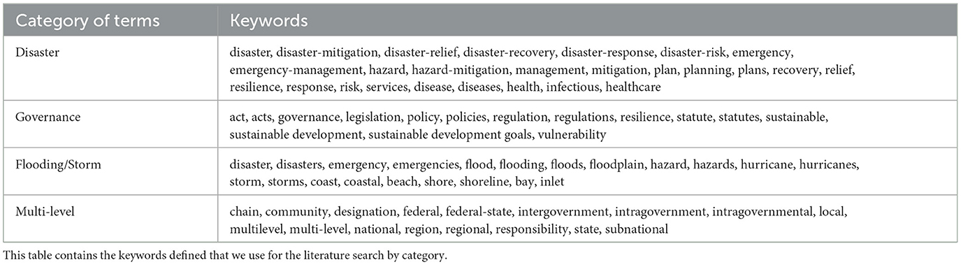
Table 1. Key search words.
We then query the Scopus database using 33 distinct combinations of the Table 1 keywords (see Appendix Table A1) using different Boolean operators (e.g., combinations of “OR,” “AND NOT,” and “AND”). We rule out keyword combinations that yielded more than 10,000 results and focused on searches that yielded fewer than 10,000 results. Of the original 33 search combinations, 26 searches yield under 10,000 results. We upload and compile the results of these searches into a reference management program (SciWheel); the software allows us to deduplicate, tag, and categorize studies. We deduplicate the results of the 26 searches and prune these references through title and abstract screening and targeted reference manager searches to ensure relevance of the results to United States or had a title directly related to multi-level governance systems and flood management, resulting in a final sample of 80 sources for the narrative review (see Appendix Table A2 for the list of 80 references). In SciWheel, we tag articles pertaining to the following terms:
climate change, climate change adaptation, compound hazards, disaster recovery, exposure, federal flood policies, flood, flood insurance, flood risk, management, hazard mitigation, housing, hurricane infrastructure, introduction, local emergency planning, natural disasters, NFIP, resilience, review article, social media, state government, urbanization, vulnerability
In tagging articles, we do not include articles that do not fit into the tagging specifications of our final review. At each stage of the pruning, two or three co-authors independently screen each potential addition to the review. At any disagreement on inclusion or exclusion of an article, all co-authors involved in the screening would discuss until they reached a consensus. We review the full text of each of these articles to produce a synthesized list of 33 highly relevant articles and book chapters (marked green in Appendix Table A2). Based on the final 33 sources, we develop a “mind map,” a diagram for the visual organization of the information in our sources. Our mind map helps us organize and demonstrate thematic relationships among pieces of the literature on flood policy and governance. We choose the references to include in the mind map based on an inductive analysis to capture direct quotations and reviewer notes, organizing and linking them into emergent themes using Coggle (https://coggle.it),6 an online tool that allows for the compilation of quotes, facts, or figures. We organize our mind map using the following themes and/or categories:
- Local Flood Programs, subdivided into sources on specific municipalities and their flood governance. The various municipalities include Boulder, CO; Boston, MA; Houston, TX; Kinston, NC; Lumberton, NC; Morehead City, NC; New Orleans, LA; New York, NY; Tampa, FL.
- State Flood programs and Policies, subdivided into California, Colorado, Florida, Louisiana, Massachusetts, North Carolina, Oregon, Texas, and possible state-level policy planning.
- Federal Flood Programs and Policies, subdivided into EPA, US Coastal Barriers Act, Road Home Program, Community Rating System, National Flood Insurance Program (NFIP), Federal Emergency Management Agency (FEMA).
- Flooding and Flood Policy's Effects on People, subdivided into Repeat Victims, Community Resilience and Stakeholder Engagement, Environmental Justice/Social Risk, Demographics.
- Data and Description, subdivided into Sea Level or Flood Data Analysis, Insurance, Risk, subdivided into Physical Risk, Financial Risk, Perception of Risk.
- Subjects of Policy Analysis, subdivided into Hurricane, Vector Borne illness, Climate Change, Descriptive Effects of Current Policy, Normative Analysis and Policy Solutions, Interlinkage/Gap Analysis, subdivided into Federal/State, Federal/Municipal, State/Municipal.
We analyze the extracted data from our 33 references and organize it in the Coggle mind map, and find three themes around the intergovernmental relations of flood governance in the United States. We use the following themes to analyze and organize our results while writing our review: interlinkages and gaps in intergovernmental relations for flooding, risk, data, and social vulnerability. Using these themes, we create an outline that combines a review of the impacts and challenges that flooding creates in the United States with key theories on intergovernmental relations and federalism. We use this outline to empirically identify gaps in governance and to find examples of both disaster policy failures and policy solutions, theoretical and empirical.
Mapping intergovernmental relations
In addition to our mind map, we also create summary tables of the various ways government structures are interlinked in Appendix B. As outlined in Appendix B, we create summary tables using a framework of guiding questions to determine the nature of the intergovernmental relations. For both legislation (Appendix Table B1) and programs and policies (Appendix Table B2), once we had a list of these structures. We derive our guiding questions to determine if an intergovernmental relationship exists as a result of the legislation, policy or program, and if so, what entities the relationship connects, the nature of the relationship, and whether a part of the relationship mandates reporting or establishes a hierarchy. The information within the tables is informed by both the studies we identity in our review of the literature and public information available on government websites and databases.
Results
In our review of the literature, we identify three overarching themes: (1) coordination across multiple jurisdictions (intergovernmental relations); (2) types of risk (financial, physical, social and individual, and perception of risk); (3) data adequacy and interoperability. The themes we identify point to a complex web of intergovernmental relations for managing floods. Flood governance intersects with housing, climate, and zoning governance, and therefore the policies, institutions, and programs governing each issue are entangled respectively (Lyles et al., 2014). Consequently, in structuring the results, the themes we've identified expose problems accentuated or engendered by intergovernmental gaps from these areas of governance. Where we identify policy recommendations from the literature, we purposefully focus on those that build resilience through the strengthening of tenuous (or nonexistent) intergovernmental relations and public/private partnerships. Papers that advocate for policy tend to do so with solutions that fall into four types: land use planning, insurance reform, and stakeholder or inter-municipality collaboration. In reviewing the three themes, our analysis exposes gaps inhibiting interconnectivity and multilevel cooperation for flood policy that are more explicitly examined through examples from the literature. We summarize the academic literature and government resources on flood policy interlinkage before describing problems with risk and flood data in the following subsections.
Interlinkages and gaps in intergovernmental relations for flooding
Evidence suggests that FEMA's history of reform and streamlining in the wake of flood disasters has yielded greater multilevel interlinkage, lending itself to quicker reaction time and relief. The literature suggests that in the past, FEMA's flexibility in response–and experience dealing with the expansion of federal guidance to states for flooding–speeds disaster project development, recovery, and implementation (Smith, 2014). Projects included pre-event hazard mitigation planning, the identification of potential stakeholders and volunteers, and a pre-negotiated agreement with FEMA that streamlined the determination of eligible flood insurance applicants (Smith, 2014). For example, 3 years after Hurricane Fran, the heavy rains of Hurricane Floyd flooded many of the same communities. Realizing that federal funding demands had outpaced supply, communities developed grant applications in anticipation of further management funding between the two storms. Additionally, federal, state and local officials, as well as private sector contractors tasked with grants management at the local level, had gained greater experience administering what is a complex, highly bureaucratic, and time-consuming program. Just one week after Hurricane Floyd Struck, state and private funds, that would eventually be supplemented by Congress, were disbursed to acquire more than 600 flooded homes (Smith, 2014).
Despite being a primary administrator of natural disaster relief programs, FEMA's poorly defined relationship with other federal and state disaster response structures is one of its major weaknesses. The lack of clear delineation of responsibilities fails to address the resulting gaps in governance and authority between state, federal, and local responsibilities. These are characterized by the agency's consistently undefined and ambiguous oversight, low participation in federal programing, and minimal guidance for state and municipal governing entities. These gaps in governance often come from a lack of organization and proper funding.
The lack of clearly defined responsibilities at the federal level have led to conflicts at various levels of authority, resulting in jurisdictional lawsuits (Tullos, 2018). Some states allege, for example, that FEMA does not comply with the Endangered Species Act (ESA). FEMA must not produce adverse impacts on threatened and endangered species as a federal agency, and yet it has been sued in multiple states for a role in enabling the degradation of habitat for such species. As a result, FEMA has injected itself into the role of supervising and restricting activities within the floodplain in some locations where habitats for threatened and endangered animals have been affected (e.g., salmon in the Puget Sound, WA; Key Deer in the Florida Keys).
The lack of clearly defined responsibilities at the federal level has also led to the ballooning of federal flood institutions' debt (Blessing et al., 2019). FEMA as a relatively semi-present and periodic federal regulator for state disaster governance has situated it primarily as a bail-out program and fund-disbursing entity. For example, while the NFIP discourages floodplain development at the state level, local governments ultimately have the authority for land use regulation, including restrictions implemented through zoning. This puts FEMA in a problematic financial position, as the number of insurance policies has outgrown the program's carrying capacity. As a result, insurance payouts by NFIP consistently exceed the income generated from premiums, and this constitutes one of FEMA's biggest financial burdens nationwide (Blessing et al., 2019). As Tullos (2018) puts it, “the historical lack of an articulated and coordinated flood-governance structure has led to a complicated blending of hierarchical, monocentric governance at the federal level with more distributed polycentric governance at the regional and local levels”. FEMA's identity crisis means that it funds and re-funds the development of known floodplain infrastructure. This has created an agency that specifies how to build within a floodplain, rather than protecting buildings and floodplain functions by discouraging inappropriate and hazardous development (Whitmore et al., 2006).
FEMA's seemingly all-encompassing set of responsibilities is a reason the agency has struggled for years to maintain financial solvency (Blessing et al., 2019; Shi and Varuzzo, 2020). For example, the NFIP alone has a debt of $20.5 billion as of 2020 (Shi and Varuzzo, 2020). Congress passed the Biggert–Waters Flood Insurance Reform Act in 2012 in part to attempt to alleviate FEMA's financial burden. It did so by raising premiums based on physical floodplain protection and avoidance in coastal watersheds. Notably, this further shifted the financial burden of flood protection to the homeowner. The public backlash that ensued was based on perceptions that increased premiums placed undue burdens on individual property owners (Blessing et al., 2019). Simultaneously, FEMA's role as funder has meant it heavily funds recovery programs that lack specificity of guidance to achieve its goals for the funding in the aftermath of flooding natural disasters. The Road Home Program (RHP), instituted in the aftermath of Hurricane Katrina was a primary example of this. Green and Olshansky (2012) argue that though the RHP was successful in allotting billions of dollars to the state of Louisiana and homeowners for rebuilding and mitigation, the unresolved tension between RHP's purpose as a rebuilding program and a compensation program created significant barriers to recovery.
Financial hardship also stems from overextension and underpricing of the NFIP insurance policies. Most residential flood insurance policies in the United States were written by the NFIP which has historically practiced a “grandfathering” of flood insurance premiums.7 When flooding conditions in a given locality (coastal or not) changed and physical risk heightened, or even when improved data gathering methods enabled an improved ability to detect risk, residents who held an NFIP policy could keep a lower rate despite higher risk and therefore, more claims. Consequently, this has resulted in a loss of financing, overextension of capabilities, and a loss of incentives for flood-proofing or relocation for homeowners in areas increasingly vulnerable to flooding. Though increasing premiums would create affordability challenges for many residents, artificially low insurance policies for these properties have resulted in serious shortfalls in revenue (Kousky et al., 2021).
Federal efforts to close funding gaps have taken a number of forms, some of which attempt to disperse funding across levels of government, and recover lost revenue. For example, The FIRA authorized the expenditure of up to $40 million to mitigate severe repetitive loss properties (RLPs), often causing non-catastrophic and costly repeated damage, and drawing heavily on the NFIP's funds (Kick et al., 2011; Blessing et al., 2019). This expenditure was approved only in the event that states mete out funds to local governments to support flood intervention activities such as property elevation, flood-proofing RLPs, property buyouts, and residential relocations. FIRA encourages interlinkage by following a chain financial transfer while ensuring that property owners who refuse offers of mitigation must pay increased insurance rates (Kick et al., 2011).
The CRS program, discussed in the Background section, hopes to spur federal/local interlinkage by motivating the purchase of flood insurance, promoting flood hazard awareness and mitigation, but evidence suggests a perverse incentive structure in certain cases. Communities that are close to the cutoff between tiers might adopt “substantially more passive” CRS activities; given that passive programs are less effective at reducing risk for the community, increased damage and losses from floods are likely (Sadiq and Noonan, 2015). Brody et al. (2009) note that Floridian localities, for example, adopted CRS policies through least-cost learning in which they disproportionately select for less expensive point-earning activities that are more politically viable, suggesting the possibility that the CRS's point system can be gamed.
Separate from its financing issues, one of FEMA's consistent major obstacles has been a lack of community and state-level engagement in programs other than the NFIP. Participation in many of these measures could minimize the strain on the NFIP finances and protect floodplain resources and minimize flood losses. Given widespread participation in FEMA's other programs, such as the CRS, financial stress on the NFIP might be lessened by the increased uptake in resilience measures required by these programs, and allow the NFIP to function more efficiently (Brody et al., 2009; Zahran et al., 2010). But participation in CRS is low in communities across the United States. In January of 2008, 1,080 communities, representing only five percent of NFIP-eligible communities at the time, had enrolled. In 2021, that figure had only increased to 1,520 (FEMA.gov, 2021). Despite the logical partnership between state and local managers, it remains challenging to coordinate activities across the state and local levels (Landry and Li, 2012).
In some cases, FEMA's failure to provide adequate funding or oversight in the past (i.e. gaps), resulted in the enhancement of state programs and increased state proactivity in the wake of flood disasters. In North Carolina, one of the state's leading the effort to improve flood resiliency, commenced typical federal responsibilities after Hurricanes Fran and Floyd. These efforts included management of emergency housing and implementation of a new long-term recovery program (Smith, 2014). The state took on related actions including the building of an enhanced state emergency management capacity, an expanded commitment to hazard mitigation, and the creation and funding of state-level recovery programs advancing the concept of sustainable disaster recovery. These efforts culminated in the largest single-state acquisition of flood-prone properties in the country. Importantly, this enabled North Carolina to map floodplains and share the data in a publicly-accessible format.8 States like Louisiana and Texas have been able to react similarly to North Carolina in the aftermath of exceptionally devastating disasters (Hurricane Katrina and Hurricane Harvey, for example) with enhanced water management programs like the Louisiana Watershed Initiative, and the state flood assessment from the Texas Water Development Board (Laska, 2020; Lake, 2021). Most state programs, however, are created as temporary post-disaster assistance, creating an episodic ebb and flow of hazard mitigation administration, data collection, and disaster recovery programs (Smith, 2014, 2020). Despite the complex and often unpredictable incentive structures of programs meant to link local and federal governance, we map out the complex multilevel interlinkages and gaps of flood governance based on the literature and publicly available government data. We summarize our findings in Appendix Tables B1–B3. Appendix Table B1, Legislation Gaps and Interlinkages, outlines how federal legislative bodies or pieces of legislation link in terms of level of governance, voluntarily or by mandate, the funding relationship, whether there's knowledge mechanisms building between levels, and reporting requirements for the legislation. Appendix Table B2, Programs and Policies Gaps and Interlinkages, presents a similar evaluation along the same metrics for programs under the jurisdiction of institutions or agencies and or that might have been enumerated by legislation. Finally, Appendix Table B3, Institutions and Agencies, lists federal agencies and describes them and related policies/programs.
Risk
Financial risk
The financial risk of flooding events is an increasing concern for the public sector, especially given the compounding impacts of climate stressors. Historically, tax and real estate structures at the national level may encourage development in coastal areas and floodplains in pursuit of greater business and individual return on investment. Since property taxes are a function of property value and are the primary source of revenue at the local government level, a 2018 report found that 6.9 feet of sea level rise would cause 2.4 million properties to lose significant real estate value which is currently providing $12 billion in property taxes (Dahl et al., 2018; Shi and Varuzzo, 2020; The Pew Charitable Trusts, 2021). However, this loss of revenue is not distributed evenly across the United States. Under projections of 6.9 feet of sea level rise, it is estimated that nationally, 120 municipalities could lose more than 20% of their property tax base, and 30 municipalities could lose 50% of their property tax base, within the next 30-year mortgage cycle (Dahl et al., 2018; Shi and Varuzzo, 2020).
In the case of coastal vulnerability, data analysis on expected sea level rise, land use, and property taxes suggests that some coastal cities may lose significant levels of municipal revenues to long-term sea level rise, while others face negligible impacts. Yet, coastal municipalities cognizant of the risks continue to fund site redevelopment projects in flood-vulnerable areas to meet present-day budgetary needs. Because reforms only hasten lost taxes, municipal governments are effectively discouraged from aligning property values and insurance premiums with climate risks (Shi and Varuzzo, 2020). This results in a tension between long term municipal, state, and federal flood risk analysis, and real-world policy decisions. Boston, Massachusetts exemplifies the tension considering its simultaneous reliance on property taxes and high sea-level rise risk. Massachusetts' coastal cities have some of the highest levels of property tax reliance in the country–with an average of 60% of total revenue (United States Census Bureau, 2012)—yet property tax is limited to 2.5% assessed property value (Schuster, 2019). As a result, municipalities tend to grow property tax bases through gentrification, coastal development expansion, and man-made land building developments as they cannot exceed the tax cap without voter approval (Shi and Varuzzo, 2020). Despite the likelihood that sea-level rise could return Boston and other Massachusetts cities to their geographic extent prior to land-making developments by 2100 (Douglas et al., 2013; Seasholes, 2018; Shi and Varuzzo, 2020), most local governments are still too financially constrained to implement state-mandated municipal vulnerability plans which could lower risk and property tax revenue. This empirical example is supported by theory on federalism and intergovernmental relations (Roberts, 2011). In the era of anthropogenic climate change and urbanization, the federal government is more greatly incentivized to efficiently plan for events of extreme magnitude that would have been rare in the past, than local governments which are more directly affected by short-term property tax revenue diminishment.
Considering the hesitance to align tax and insurance policies (and by extension, coastal development) with sea level rise, all levels of governance are unprepared for the financial risks of flooding; the ability of the NFIP for financial mitigation of flood damages is overstressed. Shi and Varuzzo (2020) discuss how the loss of property values under climate change necessitates a change in management approach at the local level. Urban planning literature describes two urban planning approaches that might emerge in the face of a diminishing tax base in heavily flooded municipalities: austerity urbanism, which leans toward reductions in services and funding cuts, and strategic management, which relies on public-private partnerships to fill the gaps (Johnston and Girth, 2012; Warner and Clifton, 2014; Shi and Varuzzo, 2020). The latter might result in public-private partnerships that create new or upgrade existing neighborhoods into resilient districts. However, those municipalities practicing austerity urbanism might cut public services and implement stern budget oversight. Such budget cuts often result in deferred capital investment and cuts to services (Peck, 2012; Warner and Clifton, 2014).
A major challenge for disaster risk management is that the rebuilding of homes, businesses, and infrastructure in flood-prone areas is encouraged by the incentives created through existing systems (Shi and Varuzzo, 2020). For instance, though homes built under current floodplain regulations will face changing risks over time, they continue to be held to the previous codes and standards that don't take into account dynamic risk assessments. Communities across the United States are grappling with regulations about building in the floodplain. In Boulder, Colorado, a community facing significant growth pressures for housing and economic development, current regulations do not restrict redevelopment of properties within the floodplains. This is slightly mitigated by some building code requirements regarding flood protection; however, Hemmati et al. (2021) note that these building codes and land use regulations do not encompass future flood risk from the increased severity and frequency of flood events due to climate change.
The NFIP allows a home to maintain a lower insurance premium indefinitely if it met regulations at the time of construction, despite flooding risk increases over time. About 70% of properties built in coastal zones with a 1% or higher chance of flooding (V zones) and other high-risk flood areas (A zones) pay for discounted flood insurance under this policy, according to the Congressional Budget Office (CBO) (2017), Kousky et al. (2021). Kousky et al. (2021) importantly noted that while this discount policy is not currently a fiscal issue, it poses a major concern for the sustainability of the NFIP given SLR projections and coastal flood risk in the future. Lower insurance premiums carry additional consequences: homeowners may be less likely to seek other risk reduction measures or improvements to their home, or they may believe that they are less at risk for hazards like flooding due to the lower costs of insurance (Krutilla, 1966; Kunreuther et al., 2013; Kousky et al., 2021). Shi and Varuzzo (2020) note that adjusting insurance premiums as well as property values to local climate risks isn't feasible when local government structures would lose property taxes with this shift. In addition, local governments have little oversight of tax structures compared to state and regional governance oversight (Landry and Li, 2012; Shi and Varuzzo, 2020; Kousky et al., 2021).
Another challenge for disaster risk management are the shortcomings associated with benefit-cost analyses (BCA, also referred to as cost-benefit analysis or CBA). For instance, BCAs typically do not incorporate factors such as social equity indicators. BCAs may also rely heavily on predetermined quantifiable values of human life or property that do not adequately reflect current estimates. FEMA's traditional funding structures use BCAs to understand the cost-effectiveness of hazard mitigation investment (Smith, 2014). In a home buyout program, for example, this would involve determining a cost ratio that compares the cost of purchasing a structure and its associated land with the “future expected losses avoided due to flooding,” which requires in-depth and time-consuming analysis to calculate (Smith, 2014). The eligibility determination process is lengthy and inefficient, requiring substantial administrative resources and capacity. It is not uncommon for funding to be distributed long after stakeholders need it (Green and Olshansky, 2012). Smith (2014) note that state agency stakeholders are coordinating with local governments in this process while simultaneously seeking additional funding support from Congress, a complicated process that may or may not result in the necessary capacity to rebuild and restructure development toward resilience.
The contentious nature of the intergovernmental relations for the achievement of such a program are on display in a relocation program of the Isle de Jean Charles, Louisiana in the first federally funded relocation project of its kind. After the island shrunk from 35 square miles to <1 square mile due to sea level rise, the U.S. Department of Housing and Urban Development (HUD) awarded Louisiana $48.3 to facilitate the resettlement of the 100 residents, who are primarily members of the Isle de Jean Charles Band of Biloxi-Chitimacha Confederation of Muskogees and United Houma Nation tribes. Disenfranchisement in the decision-making process led to a lack of trust between key community leaders and state leadership (Simms et al., 2021). Governmental decision-makers determined that present and previous permanent residents of the island displaced after 2012 would be eligible, leaving out residents displaced in previous events who contributed to generational ties and sense of community. Louisiana is also supporting a neighborhood resettlement project from Pecan Acres; these efforts to move the primarily Black residents were stymied by racial bias in the potential relocation communities (Li and Spidalieri, 2021). Successful relocation efforts will require substantial and intentional public engagement efforts in addition to intergovernmental cooperation and significant funding.
The financial structures of the buyout programs and BCAs utilized in the aftermath of Hurricane Katrina also posed challenges for recovery and resilience. Grants were calculated below pre-storm value, and the effects on homeowners in low- or middle-income housing areas were regressive. Lower grant amounts didn't consistently provide enough funds for low- and middle-income homeowners to adequately rebuild, recover, or relocate in those areas (Green and Olshansky, 2012). If the goal was to disincentivize unresilient redevelopment in urban areas vulnerable to flood and hurricane events of the future, the program failed in this regard too, as recovery efforts were consistently characterized by the minimization of costs and uncertainty in funding (Green and Olshansky, 2012). Additionally, benefit-cost analysis selects mitigation projects for areas with a previously low vulnerability status and directs funding toward the built environment rather than human needs (Emrich and Cutter, 2011; Sayers et al., 2018; Tate et al., 2021). This approach is problematic because areas of high physical vulnerability to flooding often intersect with high social inequity, referred to in the literature as “social resilience in flood mitigation” (Flatt et al., 2019; Tate et al., 2021). As other scholars have argued, a more appropriate approach would prioritize social equity concurrently with economic and built environment mitigation.
Physical risk
Physical risk, including flood or hurricane impacts on physical structures (e.g., homes and businesses), is the primary focus of flood mitigation research and policy, particularly for public infrastructures which have widely available data for analysis. Within the public sector, some critical public infrastructure tends to have lower flood risk, depending on the implementation of state and local preparedness and mitigation standards (Shi and Varuzzo, 2020). This may include public facilities such as education, health and medical, emergency response, and law enforcement, among others (Shi and Varuzzo, 2020). However, Shi and Varuzzo (2020) suggest that some sectors that provide essential services (especially in the context of disasters) have higher flood risk, including private industry, information and communication, energy, transportation, and water resources. Whether the infrastructure is owned publicly or privately, cross-sectoral partnerships are necessary to mitigate physical risk from flooding events for critical infrastructure.
Development in the floodplain remains a continuous and relatively well-studied issue, but a gap in the literature remains in evaluating the risk of critical infrastructure among policy-making efforts. As the only paper in this review to aggregate data on critical infrastructure, Qiang (2019b) notes that local governments can integrate building code and floodplain regulations into development processes, including FEMA's minimum recommendations. However, there is no requirement to impose additional flood-zone regulations, building codes, risk analyses, or resilience plans for critical infrastructure at a state or federal level (Burby, 2001; Bubeck et al., 2015; Qiang, 2019b). The lack of national legislation or standards regulating land use and development across all states, as well as the poor understanding of risks to critical infrastructure in flood-prone areas, impedes comprehensive analysis.
Social vulnerability
The social vulnerability dimension of flooding cuts across societal issues. Notably, the increased incidence of flooding is exacerbating a pre-existing housing affordability crisis in many communities across the US. this housing affordability crisis is a result of well-documented systematic oppression and racist practices such as redlining, specifically impacting lower-income households, black or african American populations, Latin populations, or other people of color (Li and Spidalieri, 2021; Lynch et al., 2021). For example, Donner and Lavariega-Montforti (2018) note that the Rio Grande valley is home to a population of almost 90% Mexican and Mexican-American residents; the area is especially vulnerable to flooding and hurricanes, exacerbated by poor drainage and informal housing structures. Public health professionals and social justice advocates are keenly aware that the lack of safe, affordable, and accessible housing contributes to poor health outcomes and contributes to conditions of poverty (Li and Spidalieri, 2021) as summarized by Li and Spidalieri (2021), “the frontline communities of climate change are frequently the same frontline communities as the housing crisis.” The systems that further oppression and poverty in the united states are entrenched in our disaster management systems, leading to disproportionate impacts during and post-disaster. Sajjad et al. (2020) suggest that high social vulnerability increases risk, even when exposed to lower levels of hazards compared to a low social vulnerability group.
The social vulnerability dimension of floods also includes human health. Moreover, floods generally disproportionately impact segments of the population that are socially vulnerable. When examining the health impact of flooding, the most pressing concerns are physical risks during the event (such as drowning or electrocution), exposure to toxins and vector-borne or water-related illnesses post-disaster, disruptions to healthcare service and systems, and physical and mental health impacts following the event (Veenema et al., 2017). Veenema et al. (2017) note that conditions, such as increases in water temperature, precipitation, and humidity are a few examples among many climate- and weather-related changes that contribute to higher incidences of waterborne disease during and following flood events. Climate change will continue to exacerbate conditions that increase the risk of illness and injury.9 Following hurricanes Katrina and Harvey, physical and mental health-related problems were well-documented, particularly for children, the elderly, and lower income households (Ashley and Ashley, 2008; Qiang, 2019a; Seong et al., 2021; Mazumder et al., 2022). A community survey of respondents in Austin, Texas found that social vulnerability has a large, negative and statistically significant effect on risk perception (Bixler et al., 2021).10
Current indicators measuring the severity of flood events tend to be financially quantifiable (e.g., business operations delayed or shut down, or monetary damages to buildings or other facilities). Even indicators that are meant to capture the social or the “people-centered” impact of floods remain solidly in the sphere of finance, such as business revenue lost from employees who cannot make it to work. There continues to be a fundamental research gap in the post-disaster timeframe to have a comprehensive understanding of who is most impacted by floods and in what ways (Blessing et al., 2019). However, the higher vulnerability of certain stakeholder groups, such as children, the elderly, or lower-income households, is clear (Tate et al., 2021; Mazumder et al., 2022).
Perception of risk
From the perspective of governance structures, risk is generally understood as the potential for future flooding and the physical damages resulting from that flooding (Kick et al., 2011). However, public perception of flood risk greatly determines how the community responds to or how local-level agencies and governments prepare for flood events. Indeed, there is a disconnect between how residents of a community understand or respond to risk and what the local governments constitute as risk (Kick et al., 2011). For instance, the local or state government might, based on floodplain maps, have a relatively established understanding of how it quantifies the risk of a flood event. This could include quantifying the likelihood of a flooding event based on data from the past base that provides an idea of what damages might be caused by that event. A homeowner might have an understanding of how their house is or is not situated within a floodplain. For both the homeowner and local governments, the perception of risk for flood damage is shaped by past events. In Lyons, Colorado, over 20% of housing was damaged during a severe rain event; Albright and Crow (2015) found that communities like Lyons that have limited financial capacity “are likely to have motivated residents and interested organizations participate in recovery and planning processes,” supporting that perception of risk is highly shaped by past damaging events.
Ultimately, perception of risk to floods often fails to take into account climate change and might result in a discontinuity between the perception of risk and actual risk. The section on data further details the problem of recommended floodplain maps concerning climate change. The measure of that risk is largely financial, quantified as NFIP claims, financial stability of businesses, or property damages following flooding. Kick et al. (2011) note that though government officials may relate on a human level to the negative physical or mental health outcomes from an event, response and mitigation systems in place do not account for non-financial damages. Perception of risk doesn't translate into implementing solutions, however. In an analysis of 56 U.S.states, territories, and the District of Columbia, Gonick and Errett (2018) found that the majority of states integration perception of risk around climate change into the required State Hazard Mitigation Plans; however, lack of funding and competing priorities undermines the movement from understand risk to mitigating risk.
Given the understanding of risk to financial systems, physical structures and infrastructure, and social vulnerability and individual wellbeing, the preparation and adoption of preparedness policies pose an opportunity to mitigate the impacts of floods. Implementing a community rating system (CRS) remains an effective measure to improve resilience to flooding for the communities that participate. Examples of programs implemented with a CRS could encompass mapping updates, implementing regulations, public safety campaigns or education and information about mitigation measures like insurance, or campaigns, and developing warning and response systems (Sadiq and Noonan, 2015).
Data adequacy and interoperability
Data is critical for evaluating the effectiveness of policies and the efficiency with which governments adhere to their responsibilities both in the anticipation of and in the wake of natural disasters. Though developing policies to encourage multilevel collaboration often makes use of the best available data, these data may not be ideal. In most instances, however, the needed data either does not exist or may measure desired information in ways that make the data hard to be operationalized (Kreibich et al., 2022).
In the case of social vulnerability, assessing social vulnerability at the community level typically involves a quantitative approach to data in one of two ways. One method involves “integrated analysis,” where flood hazard and social vulnerability data can be overlaid geographically. What results is a map that allows comparison of geographical vulnerability alongside social vulnerability indicators, and policymakers or government leaders can use the data outcomes to shape policy and prioritize the areas with high levels of social vulnerability factors and flood danger (Emrich and Cutter, 2011; Tate et al., 2021). An example is LA SAFE, the Louisiana Strategic Adaptations for Future Environments, which overlays physical risk (such as sea level rise, erosion, and flooding) with social and economic data, to “identify low-risk areas that may be more likely to receive people migrating from the coast” (Li and Spidalieri, 2021). Alternatively, indices are determined and mapped onto areas of high flood hazard risk to identify which dimensions of social vulnerability dominate (Zhang and You, 2014; Mavhura et al., 2017; Tate et al., 2021). Each approach has disadvantages; both methods employ generic indicator sets at a local scale, which can be problematic if data is limited, skewed, or poorly recorded, which can be the case at all levels of government but particularly at the local level. Additionally, the use of generic indicators of social vulnerability is problematic when the literature tends to describe conceptual consensus of social vulnerability as hazard-specific (Rufat et al., 2015). There remains limited empirical understanding of the spatial distribution and determinants of social vulnerability to floods at the national level. Such understanding is needed to support changes in flood mitigation policy toward social equity (Blessing et al., 2019).
Data inadequacy and inaccuracy are also problematic for municipalities with significant land areas in the floodplains. Notably, 500-year flood zones were incompletely delineated in 2019. Regulation and guidance on the implementation of 500-year zones standard was fragmented despite FEMA recommendations to use these zones to protect critical infrastructure (Qiang, 2019b). One study of southeastern North Carolina showed that after a flood event, approximately 44% of residential structures flooded were outside of the 100-year floodplain. Property holders make decisions on whether to buy flood insurance in part from the guidance of local hazard maps, which may no longer be accurate. If 100-year floodplain data are becoming obsolete, and the frequency of higher caliber flood events are increasing, properties previously deemed low-risk need to be re-evaluated. Comparing potential and actualized vulnerability data for coastal floods can inform improved planning and mitigation for previously low-risk geographies (Qiang, 2019b; Pricope et al., 2022).
Discussion and conclusions
In this paper, we explore the literature on intergovernmental relations in the United States in the context of flooding to identify governance gaps and interlinkages among the various jurisdictions of entities involved in flood resiliency planning and flood response. Identifying key patterns in the academic literature on flood policy can help shed light on existing inefficiencies of multi-level governance but also point to opportunities for increased coordination, a reduction in duplication of efforts, and policy innovation.
Improving governance to enable increased flood resiliency is especially important in the broader context of climate change. Rising global temperatures and the increased frequency of natural disasters will continue to result in risk on physical and environmental axes. Increased risk of disasters also underscores the importance of incorporating social vulnerability in prioritizing flood response and flood resiliency programs. Factors like urban population growth, urban development sprawl, coastal and floodplain development, and aging urban infrastructure further complicate and challenge coastal resilience to climate-related risks. Subsequently, recognizing the unique opportunity to develop adaptations and resilience to climate change complications requires national, sub-national and local jurisdictions to not only cooperate but coordinate in a comprehensive way (Bai et al., 2018; Bixler et al., 2021).
Flooding sits at the intersection of climate and housing crises, particularly in coastal urban regions; as such, flooding and the long-term effects of hurricanes disproportionately affect the most vulnerable populations (Green and Olshansky, 2012; Sovacool et al., 2018; Chakraborty et al., 2021; Li and Spidalieri, 2021). The literature acknowledges this and patterns toward policy analysis and normative policy solutions that consider social and housing inequalities inherent to flooding. Therefore, we discuss the literature's trending policy solutions that grapple with flooding, sea-level rise, and hurricanes in the context of climate-change-induced sea level rise, and frame them within a social context of inequality. Articles proposing policy solutions tend to fall into the following four categories: land use planning, insurance reform, and stakeholder or inter-municipality collaboration.
In addition to housing and manmade infrastructure, sea-level rise, storm events, and flooding also pose a threat to coastal habitats and wetlands. Research is still needed to determine geography-specific erosion and accretion rates, particularly concerning the severity of climate events (Dorman et al., 2011). Calil et al. (2015) recognized that over one-third of the NFIP's claims have been to RLPs and postulated an opportunity to align conservation with flood hazard mitigation. Flood-prone parcels of land that have natural resource conservation value often overlap with coastal zones containing RLPs. Prioritizing land buyouts within this overlap may help FEMA alleviate property loss and stabilize wetland conservation. When restored floodplains regain their natural abilities to weaken the effects of floods, they can reduce cyclical flood damage and protect coastal communities (Calil et al., 2015). The feasibility of widespread implementation of this policy is dependent on accurate floodplain data and mechanizing eminent domain for conservation, but it is one strategy that could work in states with high tax revenue and sturdy governmental institutions, like California. Another avenue for implementation could be through the collaboration of FEMA and state wildlife commissions to recalculate flood data and reform the state-specific Wildlife Action Plans [USGS State Wildlife Action Plans (SWAP), 2022] for an approach to coastal resilience that considers wetland conservation.
The human and economic costs of failures in flood control, risk analysis, and adaptation for resilience have broad applications beyond the empirical case of the United States. Future papers might compare the relevant merits and detractions to our system to another nation's, but that is not the purpose of this one, though the literature points to a dearth of research on internationally collaborative flood governance mechanisms and strategies. Indeed, whatever lack of understanding governments and the scholarly field may have for deciphering intergovernmental interlinkages and gaps in federalist flood management systems, the incomprehension of international flood resilience and response policy is greater. Flood consequences that can have broad geographic or even global effects, like increased risk of zoonotic and vector borne illness, rely in part on international collaboration to neutralize, prevent, or reduce harm (Gubler, 2010; Albano et al., 2015; Veenema et al., 2017). Lessons learned from strides in intranational flood management efforts can inform efforts to build effective interlinkages (in data sharing, knowledge sharing, and diplomatic relations for disaster management) between governments. Multi-level governance strategies that encourage the prevalence and strength of free open-source geospatial models can help build resilience beyond the capacity of one single nation (Albano et al., 2015).
Considering the technological improvements and the urgency of climate change, the literature points to a number of opportunities to improve the operability of intergovernmental relations and bridge the implicit disconnects present in a federalism of shared functions. Though the local and global economic determinants of unresilient flood governance systems can't be understated (Shi and Varuzzo, 2020; The Pew Charitable Trusts, 2021), investment in flood resilience infrastructure can yield economic dividends in decades to come (Fung et al., 2020; Yaron and Wilson, 2020). Acknowledging its relative absence from the literature, further research is needed to understand how social vulnerability is affected by flooding and how it can be considered in governance mechanisms. Given the ubiquity of private and public institutions gathering data on natural disaster, codifying policies (national and international) that incentivize the gathering and sharing of 500-year flood data between levels of government and private institutions will bolster flood data sets, leading to more efficient government responses, a more accurate foundation by which to base resilience policies, and more granular analysis of the intersection of social vulnerability and flood response (Bjerge et al., 2016; Ran and Nedovic-Budic, 2016; Jayawardene et al., 2021; Pricope et al., 2022; Valachamy et al., 2022). Beyond flood governance, improved functionality of intergovernmental relations benefits the functionality of government through improved social services and tax structures (Kazepov, 2017; Rixen and Unger, 2022).
Although more time and research is needed to analyze the effects, the Biden administration implemented a number of flood governance strategies in an attempt to fill gaps in FEMA's flood control efficacy. In March 2023, the National Climate Task force released a Federal Flood Risk Management Standard Climate-Informed Science Approach State of the Science Report to “establish a Federal Flood Risk Management Standard to ensure that agencies take actions to enhance the Nation's resilience to current and future flooding.” Key among the actions outlined in the document, was a change to the NFIP's risk assessment policy that not only eliminated the program's “grandfathering” policy in the hopes of fighting the program (and FEMA's) deficit. The program's updated pricing methodology, the “Risk Rating 2.0” updates modeling approaches to more extensively incorporate the impacts of climate change and gather more comprehensive hazard and risk data. In terms of intergovernmental relations for flood management, The Federal Flood Risk Management Standard attempts to strengthen both stakeholder input and top-down policies for flood governance. Future research must investigate the ways that the new risk assessment system affects equity and social vulnerability outcomes for flood insurance holders.
Many of the policy changes that various sources in the literature recommend (e.g., improved insurance systems, improving floodplain data, and restructuring the CRS) will require an improved understanding of how changes in climate will affect particular geographies. Successful resilience policy hinges in part on understanding climate change projections, as it is challenging to know how and to what degree to prepare across dimensions like physical and financial risk for unknown quantity and frequency of natural disasters (Smith, 2014; Gonick and Errett, 2018; Shi and Varuzzo, 2020). Better methods are needed to predict how these hazards will change over time in the face of climate change and more effectively convey these realities to the public, especially those who are skeptical of climate change. Policies must not only outline reconstruction plans and best practices (e.g., where and how communities will be rebuilt) but also reflect current and projected changes in natural hazard risk–including those caused or exacerbated by climate change (Smith, 2014).
Author contributions
AC: data curation, investigation, conceptualization, writing–original draft, and writing–review and editing. EG: writing–original draft, writing–review and editing, and supervision. CB: data curation, investigation, and writing–review and editing. AE-K: conceptualization, supervision, and writing–review and editing. KD: conceptualization, methodology, supervision, and review and editing. EC-D: investigation, conceptualization, and supervision. RR and AW: investigation and conceptualization. FD: funding acquisition. All authors contributed to the article and approved the submitted version.
Funding
This work was supported by Project 5116900, National Science Foundation (Re-Energize DR-3—a Belmont Forum Funded Project).
Conflict of interest
EG was employed by the Clarion Associates.
The remaining authors declare that the research was conducted in the absence of any commercial or financial relationships that could be construed as a potential conflict of interest.
Publisher's note
All claims expressed in this article are solely those of the authors and do not necessarily represent those of their affiliated organizations, or those of the publisher, the editors and the reviewers. Any product that may be evaluated in this article, or claim that may be made by its manufacturer, is not guaranteed or endorsed by the publisher.
Supplementary material
The Supplementary Material for this article can be found online at: https://www.frontiersin.org/articles/10.3389/frsc.2023.1135513/full#supplementary-material
Footnotes
1. ^Since 1980, floods that accompany severe storms and tropical cyclones have accounted for approximately 68.7% of natural disaster losses (National Centers for Environmental Information, 2022a,b). Floods from heavy rains also cause damage year-round on a regular basis.
2. ^The complexity of jurisdictional responsibility between governmental entities aligns closely with Marks and Hooghe's (2004) definition of “Type 2” governance, which describes jurisdictions as operating at numerous territorial scales, shifting in role and self-definition, and comprising a complex, patchwork of innumerable entities.
3. ^FEMA was created via executive order by President Jimmy Carter in 1979 with the dual missions of emergency management and civil defense.
4. ^In 1988, the U.S. Congress passed the Stafford Act, providing the first congressionally enshrined emergency management and codifying a statutory framework for disaster response and recovery.
5. ^Due to the broad and varied nature of the literature/search and sheer quantity of results, our systematic search resulted in a large number of results, requiring significant pruning. Ultimately what started as a systematic search ended in a narrative review informed by a subset of systematic search results.
6. ^Mind map available on request.
7. ^In 2022, FEMA updated its pricing methodology with its “Risk Rating 2.0,” which more extensively incorporates the impacts of climate change and gathers more comprehensive hazard and risk data. Additionally, it eliminated the program's “grandfathering” policy in the hopes of fighting the program (and FEMA's) deficit.
8. ^North Carolina's online flood map can be accessed at https://flood.nc.gov/ncflood/.
9. ^Veenema et al. (2017) describe how climate change increases disease vector numbers and ranges through relocations and migrations related to climate change induced disaster and sea-level rise (Portier et al., 2010). Warmer environments also shorten pathogen incubation periods for vector-borne illnesses like Dengue, Dengue Hemorrhagic fever, yellow fever, and West Nile Virus.
10. ^Austin, Texas, is considered the “flash flood alley” of Texas. Texas is among the states with the highest number of flood fatalities (Bixler et al., 2021).
References
Adger, W. N., Arnell, N. W., and Tompkins, E. L. (2005). Successful adaptation to climate change across scales. Global Environ. Change 15, 77–86. doi: 10.1016/j.gloenvcha.2004.12.005
Albano, R., Mancusi, L., Sole, A., and Adamowski, J. (2015). Collaborative strategies for sustainable EU flood risk management: FOSS and geospatial tools—challenges and opportunities for operative risk analysis. ISPRS 4, 2704–2727. doi: 10.3390/ijgi4042704
Albright, E. A., and Crow, D. A. (2015). Learning processes, public and stakeholder engagement: analyzing responses to Colorado's extreme flood events of 2013. Urban Climate 14, 79–93. doi: 10.1016/j.uclim.2015.06.008
Amundsen, H., Berglund, F., and Westskog, H. (2010). Overcoming barriers to climate change adaptation—a question of multilevel governance? Environ. Plan. Gov. Policy 28, 276–289. doi: 10.1068/c0941
Ashley, S. T., and Ashley, W. S. (2008). Flood fatalities in the United States. J. Appl. Meteorol. Climatol. 47, 805–818. doi: 10.1175/2007JAMC1611.1
Bai, X., Dawson, R. J., Ürge-Vorsatz, D., Delgado, G. C., Salisu Barau, A., Dhakal, S., et al. (2018). Six research priorities for cities and climate change. Nature 7694, 23–25. doi: 10.1038/d41586-018-02409-z
Billion-Dollar Weather Climate Disasters | National Centers for Environmental Information (NCEI) (2022). Available at: https://www.ncei.noaa.gov/access/billions/summary-stats (accessed December 30, 2022).
Bixler, R. P., Paul, S., Jones, J., Preisser, M., and Passalacqua, P. (2021). Unpacking adaptive capacity to flooding in urban environments: social capital, social vulnerability, and risk perception. Front. Water 3, 728730. doi: 10.3389/frwa.2021.728730
Bjerge, B., Clark, N., Fisker, P., and Raju, E. (2016). Technology and information sharing in disaster relief. PloS ONE 11, e0161783. doi: 10.1371/journal.pone.0161783
Blessing, R., Brody, S. D., and Highfield, W. E. (2019). Valuing floodplain protection and avoidance in a coastal watershed. Disasters 43, 906–925. doi: 10.1111/disa.12409
Brody, S. D., Zahran, S., Highfield, W. E., Bernhardt, S. P., and Vedlitz, A. (2009). Policy learning for flood mitigation: a longitudinal assessment of the community rating system in Florida. Risk Anal. 29, 912–929. doi: 10.1111/j.1539-6924.2009.01210.x
Bubeck, P., Kreibich, H., Penning-Rowsell, E. C., Botzen, W. J. W., De Moel, H., Klijn, F., et al. (2015). Explaining differences in flood management approaches in Europe and in the USA - a comparative analysis. J. Flood Risk Manage. 5, 151. doi: 10.1111/jfr3.12151
Burby, R. J. (2001). Flood insurance and floodplain management: the US experience. Environ. Hazards 3, 111–122. doi: 10.3763/ehaz.2001.0310
Calil, J., Beck, M. W., Gleason, M., Merrifield, M., Klausmeyer, K., Newkirk, S., et al. (2015). Aligning natural resource conservation and flood hazard mitigation in california. PLoS ONE 10, e0132651. doi: 10.1371/journal.pone.0132651
Carter, A., Richards, R., and Goldstein, M. (2019). Midwestern Floods Are Worsening the Gulf's Toxic Algae Problem. Center for American Progress. Available online at: https://www.americanprogress.org/issues/green/news/2019/07/09/471883/midwestern-floods-worsening-gulfs-toxic-algae-problem/ (accessed June 16, 2020).
Chakraborty, J., McAfee, A. A., Collins, T. W., and Grineski, S. E. (2021). Exposure to hurricane harvey flooding for subsidized housing residents of Harris County, Texas. Nat. Hazards 106, 2185–2205. doi: 10.1007/s11069-021-04536-9
Climate Adaptation - Drinking Water Quality and Health | US EPA (2022). Available online at: https://www.epa.gov/arc-x/climate-adaptation-drinking-water-quality-and-health (accessed December 22, 2022).
Congressional Budget Office (CBO) (2017). The National Flood Insurance Program: Financial Soundness and Affordability, Washington, DC, Congress of the United States.
Dahl, K., Cleetus, R., Spanger-Siegfried, E., Udvardy, S., Caldas, A., and Worth, P. (2018). Underwater: Rising Seas, Chronic Floods, and the Implications for Us Coastal Real Estate. Cambridge, MA: Union of Concerned Scientists. Available online at www.ucsusa.org/sites/default/files/attach/2018/06/underwater-analysis-full-report.pdf
Dahl, K. A., Spanger-Siegfried, E., Caldas, A., and Udvardy, S. (2017). Effective inundation of continental United States communities with 21st century sea level rise. Elem. Sci. Anth. 5, 37. doi: 10.1525/elementa.234
Di Gregorio, D., Fatorelli, M., Paavola, L., Locatelli, J., Pramova, B., Nurrochmat, E., et al. (2019). Multi-level governance and power in climate change policy networks. Global Environ. Change 54, 64–77. doi: 10.1016/j.gloenvcha.2018.10.003
Donner, W. R., and Lavariega-Montforti, J. (2018). Ethnicity, income, and disaster preparedness in Deep South Texas, United States. Disasters 42, 719–733. doi: 10.1111/disa.12277
Dorman, J. K., Batten, B. K., and Hosking, A. (2011). “Shaping sea-level rise adaptation policy through science: the north carolina sea level rise risk management study,” in Solutions to Coastal Disasters 2011. Presented at the Solutions to Coastal Disasters Conference 2011, eds L. A. Wallendorf, C. Jones, L. (Reston, VA: Ewing American Society of Civil Engineers), 511–521.
Dottori, F., Szewczyk, W., Ciscar, J. C., Zhao, F., Alfieri, L., Hirabayashi, Y., et al. (2018). Increased human and economic losses from river flooding with anthropogenic warming. Nat. Clim. Change 8, 781–786. doi: 10.1038/s41558-018-0257-z
Douglas, E., Kirshen, P., Li, V., Watson, C., and Wormser, J. (2013). Preparing for the Rising Tide. Environmental, Earth, and Ocean Sciences Faculty Publication Series. Available at: https://scholarworks.umb.edu/envsty_faculty_pubs/3/ (accessed September 4, 2023).
Elazar, D. J. (1962). The American partnership, intergovernmental cooperation in the nineteenth-century United States. Am. Polit. Sci. Rev. 57, 187–188.
Emrich, C. T., and Cutter, S. L. (2011). Social vulnerability to climate-sensitive hazards in the southern United States. Weather Clim. Soc. 3, 193–208. doi: 10.1175/2011WCAS1092.1
Federal Emergency Management Agency Department of Homeland Security (2021). Title 44 Emergency Management and Assistance, Chapter 1, Subchapter B, Section 77. 6. Code of Federal Regulations. Herndon, VA: FEMA.
FEMA.gov (2021). Community Rating System Overview and Participation. Available online at: https://www.fema.gov/fact-sheet/community-rating-system-overview-and-participation (accessed December 30, 2022).
FEMA.gov (2022a). Federal Flood Risk Management Standard. Available online at: https://www.fema.gov/floodplain-management/intergovernmental/federal-flood-risk-management-standard (accessed August 25, 2023).
FEMA.gov (2022b). How a Disaster Gets Declared. Available online at: https://www.fema.gov/disaster/how-declared (accessed December 22, 2022).
FEMA.gov (2022c). Reports & Data. Available online at: https://www.fema.gov/about/reports-and-data (accessed December 22, 2022).
Flatt, V. B., Flourney, A., Sokol, K. C., Verchick, R. R. M., Bratspies, R. R. M., Burkett, M., et al. (2019). From surviving to thriving: equity in disaster planning and recovery. SSRN Electr. J. 12, 133. doi: 10.2139/ssrn.3340133
Fung, J. F., Helgeson, J. F., Webb, D. H., O'Fallon, C. M., and Cutler, H. (2020). Does resilience yield dividends? Co-benefits of investing in increased resilience in Cedar Rapids. Econ. Syst. Res. J. Int. Assoc. 32, 359. doi: 10.1080/09535314.2020.1798359
Gonick, S., and Errett, N. (2018). Integrating climate change into hazard mitigation planning: a survey of state hazard mitigation officers. Sustainability 10, 4150. doi: 10.3390/su10114150
Gordon, K. (2014). Risky Business: The Economic Risks of Climate Change in the United States. Risky Business Project. Cham: Springer.
Green, T. F., and Olshansky, R. B. (2012). Rebuilding housing in New Orleans: the road home program after the Hurricane Katrina disaster. Hous. Policy Debate 22, 75–99. doi: 10.1080/10511482.2011.624530
Grodzins, M., Elazar, D. J., and Martin, R. C. (1967). The American system. Am. Polit. Sci. Rev. 61, 1108–1109. doi: 10.2307/1953412
Gubler, D. J. (2010). “The Global Threat of Emergent/Re-emergent Vector-Borne Diseases,” in Vector Biology, Ecology and Control, eds P. W. Atkinson (Dordrecht: Springer), 39–62.
Hemmati, M., Mahmoud, H. N., Ellingwood, B. R., and Crooks, A. T. (2021). Unraveling the complexity of human behavior and urbanization on community vulnerability to floods. Sci. Rep. 11, 20085. doi: 10.1038/s41598-021-99587-0
IPCC (2012). Changes in Climate Extremes and their Impacts on the Natural Physical Environment. Available online at: https://www.ipcc.ch/report/managing-the-risks-of-extreme-events-and-disasters-to-advance-climate-change-adaptation/changes-in-climate-extremes-and-their-impacts-on-the-natural-physical-environment/ (accessed December 22, 2022).
Ishtiaque, A., Eakin, H., Vij, S., Chhetri, N., Rahman, F., Huq, S., et al. (2021). Multilevel governance in climate change adaptation in Bangladesh: structure, processes, and power dynamics. Reg. Environ. Change 21, 75. doi: 10.1007/s10113-021-01802-1
Jayawardene, V., Huggins, T. J., Prasanna, R., and Fakhruddin, B. (2021). The role of data and information quality during disaster response decision-making. Prog. Disaster Sci. 12, 100202. doi: 10.1016/j.pdisas.2021.100202
Johnston, J. M., and Girth, A. M. (2012). Government contracts and managing the market. Admin. Soc. 44, 3–29. doi: 10.1177/0095399711417396
Kazepov, Y. (2017). Rescaling Social Policies towards Multilevel Governance in Europe: Some Reflections on Processes at Stake and Actors Involved in Kazepov, Rescaling Social Policies: Towards Multilevel Governance in Europe. London: Routledge, 35–72.
Kick, E. L., Fraser, J. C., Fulkerson, G. M., McKinney, L. A., and De Vries, D. H. (2011). Repetitive flood victims and acceptance of FEMA mitigation offers: an analysis with community-system policy implications. Disasters 35, 510–539. doi: 10.1111/j.1467-7717.2011.01226.x
Kousky, C., Kunreuther, H., Xian, S., and Lin, N. (2021). Adapting our flood risk policies to changing conditions. Risk Anal. 41, 1739–1743. doi: 10.1111/risa.13692
Kreibich, H., Van Loon, A. F., Schröter, K., Ward, P. J., Mazzoleni, M., and Sairam, N. (2022). The challenge of unprecedented floods and droughts in risk management. Nature 608, 80–86. doi: 10.1038/s41586-022-04917-5
Krutilla, J. V. (1966). An economic approach to coping with flood damage. Water Res. Res. 2, 183–190. doi: 10.1029/WR002i002p00183
Kunreuther, H. C., Pauly, M. V., and McMorrow, S. (2013). Insurance and Behavioral Economics Improving Decisions in the Most Misunderstood Industry. Cambridge, MA: Cambridge University Press.
Lake, P. (2021). Texas reimagines the fight against floods. Texas Water J. 12, 58–67. doi: 10.21423/twj.v12i1.7133
Landry, C. E., and Li, J. (2012). Participation in the community rating system of NFIP: Empirical analysis of North Carolina counties. Nat. Hazards Rev. 13, 205–220. doi: 10.1061/(ASCE)NH.1527-6996.0000073
Laska, S. (2020). “Introduction to the book: ‘ahead of the curve',” in Louisiana's response to Extreme Weather: A Coastal State's Adaptation Challenges and Successes, ed Laska, S (Cham: Springer International), 1–31.
Li, J., and Spidalieri, K. (2021). Home is where the safer ground is: the need to promote affordable housing laws and policies in receiving communities. J. Environ. Stud. Sci. 11, 682–695. doi: 10.1007/s13412-021-00702-4
Lyles, W., Berke, P., and Smith, G. (2014). A comparison of local hazard mitigation plan quality in six states, USA. Landscape Urban Planning 122, 89–99. doi: 10.1016/j.landurbplan.2013.11.010
Lynch, E. E., Malcoe, L. H., Laurent, S. E., Richardson, J., Mitchell, B. C., and Meier, H. C. S. (2021). The legacy of structural racism: associations between historic redlining, current mortgage lending, and health. SSM Pop. Health 14, 100793. doi: 10.1016/j.ssmph.2021.100793
Marks, G., and Hooghe, L. (2004). Contrasting Visions of Multi-level Governance, in Multi-level Governance. Oxford: Oxford University Press, 15–30.
Mavhura, E., Manyena, B., and Collins, A. E. (2017). An approach for measuring social vulnerability in context: the case of flood hazards in Muzarabani district, Zimbabwe. Geoforum 86, 103–117. doi: 10.1016/j.geoforum.2017.09.008
Mazumder, L. T., Landry, S., and Alsharif, K. (2022). Coastal cities in the Southern US floodplains: an evaluation of environmental equity of flood hazards and social vulnerabilities. Appl. Geograph. 138, 102627. doi: 10.1016/j.apgeog.2021.102627
Munene, M. B., Swartling, Å. G., and Thomalla, F. (2018). Adaptive governance as a catalyst for transforming the relationship between development and disaster risk through the Sendai Framework? Int. J. Disas. Risk Reduc. 28, 653–663. doi: 10.1016/j.ijdrr.2018.01.021
National Centers for Environmental Information (2022a). Billion-Dollar Weather and Climate Disasters. Available online at: https://www.ncei.noaa.gov/access/billions/summary-stats (accessed December 30, 2022).
National Centers for Environmental Information (2022b). Storm Events Database. Available online at: https://www.ncdc.noaa.gov/stormevents/ (accessed December 22, 2022).
National Commission on Terrorist Attacks Upon the United States (2004). Available online at: https://govinfo.library.unt.edu/911/report/index.htm (accessed July 24, 2023).
Ongaro, E., Massey, A., Holzer, M., and Wayenberg, E. (2010). Governance and Intergovernmental Relations in the European Union and the United States: Theoretical Perspectives. Cheltenham: Edward Elgar Publishing Limited.
Ongaro, E., Massey, A., Holzer, M., and Wayenberg, E. (2011). Policy, Performance and Management in Governance and Intergovernmental Relations. Cheltenham: Edward Elgar Publishing Limited.
Portier, C. J., Thigpen Tart, K., Carter, S. R., Dilworth, C. H., Grambsch, A. E., Gohlke, J., et al (2010). A human health perspective on climate change: A report outlining the research needs on the human health effects of climate change. Research Triangle Park, NC: Environmental Health Perspectives/National Institute of Environmental Health Sciences. Retrieved from www.niehs.nih.gov/climatereport
Pricope, N. G., Hidalgo, C., Pippin, J. S., and Evans, J. M. (2022). Shifting landscapes of risk: quantifying pluvial flood vulnerability beyond the regulated floodplain. J. Environ. Manage. 304, 114221. doi: 10.1016/j.jenvman.2021.114221
Qiang, Y. (2019a). Disparities of population exposed to flood hazards in the United States. J. Environ. Manage. 232, 295–304. doi: 10.1016/j.jenvman.2018.11.039
Qiang, Y. (2019b). Flood exposure of critical infrastructures in the United States. Int. J. Disaster Risk Reduc. 39, 101240. doi: 10.1016/j.ijdrr.2019.101240
Ran, J., and Nedovic-Budic, Z. (2016). Integrating spatial planning and flood risk management: a new conceptual framework for the spatially integrated policy infrastructure. Comput. Environ. Urban Syst. 57, 68–79. doi: 10.1016/j.compenvurbsys.2016.01.008
Rixen, T., and Unger, B. (2022). Taxation: a regulatory multilevel governance perspective. Reg. Gov. 16, 621–633. doi: 10.1111/rego.12425
Roberts, P. S. (2011). “Dispersed Federalism: Regional Governance for Disaster Policy,” in Policy, Performance and Management in Governance and Intergovernmental Relations: Transatlantic Perspectives, eds E. Ongaro, A. Massey, and M. Holzer (Cheltenham: Edward Elgar Publishing Limited), 114–142.
Rufat, S., Tate, E., Burton, C. G., and Maroof, A. S. (2015). Social vulnerability to floods: review of case studies and implications for measurement. Int. J. Disaster Risk Reduc. 14, 470–486. doi: 10.1016/j.ijdrr.2015.09.013
Sadiq, A.-A., and Noonan, D. (2015). Local capacity and resilience to flooding: community responsiveness to the community ratings system program incentives. Nat. Hazards 78, 1413–1428. doi: 10.1007/s11069-015-1776-9
Sajjad, M., Lin, N., and Chan, J. C. L. (2020). Spatial heterogeneities of current and future hurricane flood risk along the U.S. Atlantic and Gulf coasts. Sci. Total Environ. 713, 136704. doi: 10.1016/j.scitotenv.2020.136704
Sayers, P., Penning-Rowsell, E. C., and Horritt, M. (2018). Flood vulnerability, risk, and social disadvantage: current and future patterns in the UK. Reg. Environ. Change 18, 339–352. doi: 10.1007/s10113-017-1252-z
Schuster, L. (2019). The Rise and Fall of Local Aid in Massachusetts. Massachusetts: Massachusetts Budget and Policy Center.
Seasholes, N. S. (2018). Gaining Ground: A History of Landmaking in Boston Illustrated. Boston, MA: MIT Press.
Seong, K., Losey, C., and Van Zandt, S. (2021). To rebuild or relocate? Long-term mobility decisions of hazard mitigation grant program (HMGP) recipients. Sustainability 13, 8754. doi: 10.3390/su13168754
Shi, L., and Varuzzo, A. M. (2020). Surging seas, rising fiscal stress: Exploring municipal fiscal vulnerability to climate change. Cities 100, 102658. doi: 10.1016/j.cities.2020.102658
Simms, J. R. Z., Waller, H. L., Brunet, C., and Jenkins, P. (2021). The long goodbye on a disappearing, ancestral island: a just retreat from Isle de Jean Charles. J. Environ. Sci. 11, 316–328. doi: 10.1007/s13412-021-00682-5
Smith, A. B. (2020). 2010-2019: A Landmark Decade of U.S. Billion-Dollar Weather and Climate Disasters, NOAA Climate.gov. Available online at: https://www.climate.gov/news-features/blogs/beyond-data/2010-2019-landmark-decade-us-billion-dollar-weather-and-climate (accessed December 6, 2020).
Smith, A. B. and NOAA National Centers For Environmental Information (2023). U.S. Billion-dollar Weather and Climate Disasters, 1980 - present (NCEI Accession 0209268). NOAA National Centers for Environmental Information. doi: 10.25921/stkw-7w73
Smith, G. P. (2014). “Applying hurricane recovery lessons in the united states to climate change adaptation: hurricanes fran and floyd in North Carolina, USA,” in Adapting to Climate Change, eds B. C. Glavovic, G. P. Smith (Dordrecht: Springer Netherlands), 193–229. doi: 10.1007/978-94-017-8631-7_9
Sovacool, B. K., Tan-Mullins, M., and Abrahamse, W. (2018). Bloated bodies and broken bricks: power, ecology, and inequality in the political economy of natural disaster recovery. World Dev. 110, 243–255. doi: 10.1016/j.worlddev.2018.05.028
Tate, E., Rahman, M. A., Emrich, C. T., and Sampson, C. C. (2021). Flood exposure and social vulnerability in the United States. Nat. Hazards 106, 435–457. doi: 10.1007/s11069-020-04470-2
The Midterm Review of the Implementation of the Sendai Framework for Disaster Risk Reduction 2015-2030: Voluntary National Report – United States of America (2022). National Report to United Nations. United Nations: The Science for Disaster Reduction Interagency Working Group of the White House National Science and Technology Council's Subcommittee for Resilience Science and Technology, 1–19. Available online at: https://sendaiframework-mtr.undrr.org/quick/74932 (accessed July 24, 2023).
The Pew Charitable Trusts (2021). How Local Governments Raise Their Tax Dollars. Available online at: https://www.pewtrusts.org/en/research-and-analysis/data-visualizations/2021/how-local-governments-raise-their-tax-dollars (accessed December 22, 2022).
Trujillo, M., Baas, S., and Lombardi, N. (2015). The Impact of Disasters on Agriculture and Food Security. Rome: Food and Agriculture Organization of the United Nations.
Tullos, D. (2018). Opinion: how to achieve better flood-risk governance in the United States. Proc. Natl. Acad. Sci. USA 115, 3731–3734. doi: 10.1073/pnas.1722412115
United States Census Bureau (2012). 2012 Census of Governments - Organization (no date). Available at: https://www.census.gov/data/tables/2012/econ/gus/2012-governments.html (accessed September 4, 2023).
USGS State Wildlife Action Plans (SWAP) (2022). Species of Greatest Conservation Need (SGCN): Home (no date). Available online at: https://www1.usgs.gov/csas/swap/ (accessed December 31, 2022).
Valachamy, M., Sahibuddin, S., Ahmad, N. A., and Bakar, N. A. A. (2022). Critical success factors for geospatial data sharing in disaster management. IOP Conf. Ser. Earth Environ. Sci. 1064, 12038. doi: 10.1088/1755-1315/1064/1/012038
Veenema, T. G., Thornton, C. P., Lavin, R. P., Bender, A. K., Seal, S., Corley, A., et al. (2017). Climate change-related water disasters' impact on population health. J. Nurs. Scholarsh. 49, 625–634. doi: 10.1111/jnu.12328
Warner, M. E., and Clifton, J. (2014). Marketisation, public services and the city: the potential for Polanyian counter movements. Cambridge J. Reg. Econ. Soc. 7, 45–61. doi: 10.1093/cjres/rst028
White House Report (2006). Hurricane Katrina: Lessons Learned - Chapter Five: Lessons Learned. Available online at: https://georgewbush-whitehouse.archives.gov/reports/katrina-lessons-learned/chapter5.html (accessed August 24, 2023).
Whitmore, F., Bernstein, G., Conrad, D., DiVincenti, C., Larson, L., Plasencia, D., et al. (2006). NFIP Evaluation Final Report Working Group. New York, NY: American Research Institute, American Research Institute.
Yaron, G., and Wilson, D. (2020). Estimating the economic returns tocommunity-level interventions that build resilience to flooding. J. Flood Risk Manage. 13, 12662. doi: 10.1111/jfr3.12662
Zahran, S., Brody, S. D., Highfield, W. E., and Vedlitz, A. (2010). Non-linear incentives, plan design, and flood mitigation: the case of the Federal Emergency Management Agency's community rating system. J. Environ. Plann. Manage. 53, 219–239. doi: 10.1080/09640560903529410
Keywords: multi-level governance, disaster and risk management, United States, flood-control risk evaluation, review, intergovernmental relations
Citation: Chantilas A, El-Khattabi AR, Gvino E, Downs K, Byrne C, Christenson-Diver E, Ruffins R, Worley A and Dodds F (2023) Interlinkages and gaps: a review of the literature on intergovernmental relations for flood management in the face of climate change. Front. Sustain. Cities 5:1135513. doi: 10.3389/frsc.2023.1135513
Received: 01 January 2023; Accepted: 28 August 2023;
Published: 25 September 2023.
Edited by:
Oliver Hensengerth, Northumbria University, United KingdomReviewed by:
Sirkku Juhola, University of Helsinki, FinlandEdoardo Ongaro, The Open University, United Kingdom
Copyright © 2023 Chantilas, El-Khattabi, Gvino, Downs, Byrne, Christenson-Diver, Ruffins, Worley and Dodds. This is an open-access article distributed under the terms of the Creative Commons Attribution License (CC BY). The use, distribution or reproduction in other forums is permitted, provided the original author(s) and the copyright owner(s) are credited and that the original publication in this journal is cited, in accordance with accepted academic practice. No use, distribution or reproduction is permitted which does not comply with these terms.
*Correspondence: Felix Dodds, felix007@email.unc.edu