Community gardens for inclusive urban planning in Padua (Italy): implementing a participatory spatial multicriteria decision-making analysis to explore the social meanings of urban agriculture
 Daniele Codato
 Denis Grego
 Francesca Peroni
- 1Department of Civil, Environmental and Architectural Engineering, University of Padua, Padua, Italy
- 2Department of Biology, University of Padua, Padua, Italy
Urban agriculture is recognized as a worthy resource to support a growing population as well as to provide other positive effects on urban ecosystems and their citizens. In this context, community gardens are considered key topics in terms of food production and food security, in both developing and developed countries, as well as in terms of social inclusion and participation. The general aim of this study was to assess the main spatial criteria recognized and shared by stakeholders to identify suitable and inclusive areas for community gardens by testing and developing a participatory process. Because of its size, population, and urban fabric, Padua (northeast Italy) was selected as a representative and emblematic case study for mid-sized cities in Europe. The methodology was based on field surveys of key informants and spatial multicriteria decision-making analysis in the open-source geographic information system environment of QGIS. The results identified neighborhoods to be prioritized in the design of new community gardens according to three scenarios: the distance index, the social index, and the combination of the two (overall index). To conclude, this study highlighted the importance of adopting a decision-making methodology to support local policymakers and municipal agencies that are interested in implementing other community gardens in Padua. The case study and the methodology adopted could also serve as important guides for cities by providing step-by-step processes that can be directly applied.
1 Introduction
1.1 Urban agriculture and community gardens
Worldwide, one of the major issues of the next few decades is how to feed a growing population (Fouilleux et al., 2017). This topic is particularly exacerbated in urban contexts, where it is estimated that most people will live in the next few decades. In this framework, the strict dependency to supply food among cities and rural areas could become unsustainable in future (Bloem and de Pee, 2017). However, the space for food in cities is limited for two main reasons. First, until recently, urban planning allocated primarily the hinterlands as areas for food production to prevent public health issues (Mubvami and Mushamba, 2006). Second, nowadays, competition to take land and soil among settlements, transport areas, and green areas is sharply increasing, thereby reducing the potential space for food (Olsson et al., 2016; Peroni et al., 2022b).
In this framework, urban agriculture is recognized as a worthy resource for food supply, as urban areas are producers of 15–20% of the world’s food (Worldwatch Institute, 2011). They can provide fresh and local food to urban dwellers by supporting a healthy diet and fostering food security at the same time (Cabannes and Marocchino, 2018; Siegner et al., 2018).
In addition, urban agriculture has other positive effects on urban ecosystems and their citizens, such as supporting climate change resilience and adaptation, which is in accordance with the European Green Deal, providing different urban Ecosystem Services (ES), and contributing to the network of green infrastructures and nature-based solutions of a city (Sanyé-Mengual et al., 2018; Peroni et al., 2022a). Urban agriculture plays an important role in mitigating urban heat islands, addressing the soil sealing phenomenon, regulating water runoff, and providing benefits for pollinators, due to plant variety (Matteson et al., 2008; Gittleman et al., 2017; Pristeri et al., 2021; Romanovska et al., 2022).
Scientific literature has also recognized the added value of urban agriculture in terms of human wellbeing and quality of life by improving the living environment through recreational and cultural activities (Harada et al., 2021; Ilieva et al., 2022). Urban agriculture is likewise identified as a worthy alternative to the reuse of vacant and abandoned land as, for example, reported by Newell et al. (2022) in a Detroit case study.
The integration of agriculture into the urban planning of cities should represent a fundamental strategy in sustainability agendas (Bartolome et al., 2022). Therefore, it should be of paramount importance for local policymakers to plan, allocate, and manage potential areas designated for agriculture in cities. In this framework, Singapore is a good example; despite the city-state ranking first in the global food security index, local production is fostered through policy support, particularly by increasing self-sufficiency by 2030 to meet 30% of the country’s food demand (Diehl et al., 2020).
Urban agriculture currently encompasses different categories: urban forests, rooftop gardens, residential and community gardens, guerrilla gardens, vertical farms, balconies, schoolyard greenhouses, and vacant lands (Oda et al., 2018; Goodman and Minner, 2019). In this context, community gardens are considered key topics in urban agriculture in terms of food production and food security, in both developing and developed countries, as well as in terms of social inclusion and participation (Kafle et al., 2022). To date, there is no uniform and unique definition of community gardens. According to Zheng et al. (2023), eight main definitions of community gardens are not always able to encapsulate the different meanings attributed to them by participants of community gardens. Comparing the different literature definitions with the types of community gardens investigated in this study, we chose to describe them following Kingsley et al.’s (2009), p. 209 definition: “plots of land allocated to individuals to create gardens of their choice in a communal environment.”
1.2 Benefits of community gardens and the identification of their best and fairest locations
Community gardens have been recognized as providing multiple benefits to local communities and urban dwellers. Besides their main documented role in guaranteeing food security, they play an important role in environmental restoration, biodiversity support, and environmental education (Caneva et al., 2020). Their supportive roles in social inclusion and integration (Turner et al., 2011; Christensen et al., 2019), the maintenance of physical and mental wellbeing (Lampert et al., 2021; Litt et al., 2023), community empowerment and development (Cumbers et al., 2018), and the promotion of social interactions across generations (Yotti Kingsley and Townsend, 2006) have also been reported.
Overall, the scientific literature has extensively studied the siting of urban agriculture resources in relation to food security, nutrition, and the social dimensions of community gardens, while less attention has been given to their contributions as green infrastructure to the urban ecosystem. In a recent bibliometric analysis of urban community garden systems, how community gardens are defined as nature-based interventions is among the emerging research topics (Zheng et al., 2023). The incorporation of both the social and environmental dimensions to identify the best locations to be prioritized for the siting of a community garden could therefore be challenging despite the large availability of remote-sensing technologies, such as high-resolution aerial images and Geographic Information System (GIS) technologies.
In this context, multicriteria decision analysis (MCDA) coupled with GIS, which improves the spatial dimension (spatial MCDA, hereafter sMCDA), could be a useful tool for supporting local stakeholders and policymakers when deciding where to locate community gardens. According to Smith et al. (2021), systematic and quantitative methods, such as MCDA, for strategic siting have received less attention, and few community garden studies that specifically call for the application of MCDA as a means of siting community gardens have been identified. However, MCDA has been widely adopted in decision-making processes for other decisions (Smith et al., 2017; Boggia et al., 2018; Cinelli et al., 2020).
It is also important to highlight that many studies have mainly investigated distance criteria (Kyoi, 2023), for example, by examining how far the site of urban agriculture is from the houses of urban dwellers (Bergstrom et al., 2009) or the spatial distance between green spaces and residents in Berlin (Bertram and Rehdanz, 2015), with less consideration of involvement of stakeholders (Bousquet et al., 2023).
1.3 Objectives
In this context, the general aim of this study was to assess the main spatial criteria shared and recognized by stakeholders to identify suitable and inclusive areas for community gardens. These criteria will incorporate both social and environmental dimensions. The specific aims were as follows:
1. To test and develop a participatory process for spatial criteria definition and weighting for locations of democratic community gardens.
2. To identify suitable and prioritized urban areas for community urban gardens in public spaces.
3. To understand the main reasons why urban dwellers are encouraged to cultivate community gardens.
1.4 Study area
The study area identified in this research is the city of Padua, located in northeast Italy. Figure 1 shows the municipality boundaries and the 40 urban units (hereafter UUs, the sub-urban division used for management and statistical purposes).
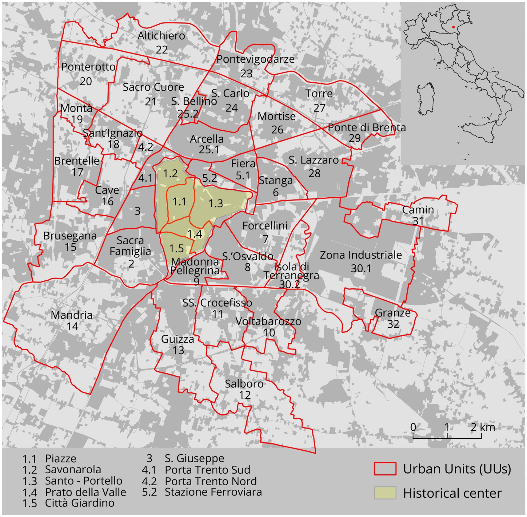
Figure 1. Map of Padua (the study area) and its location in Italy. The figure highlights the 40 urban units (UUs) and the historical center.
Because of its size, population, and urban fabric, Padua was selected as a representative and emblematic case study for mid-sized cities in Europe characterized by a medieval downtown. The municipal territory of the city occupies an area of 93.3 km2, with approximately 211,000 inhabitants (Comune di Padova, 2021).
The city is ranked among the top five Italian cities with the highest soil sealing (Munafò, 2022); indeed, 50% of the urban territory is covered by impervious surfaces (Pristeri et al., 2020). As a result, the competition for land among different stakeholders is intense, and there is a high risk of reducing the space for the implementation of new community gardens.
It is important to highlight that, as in other European and North American cities (Anguelovski et al., 2022), Padua faces potential green gentrification focused on fostering and implementing green spaces with the enactment of the New Urban Plan (Piano degli Interventi); the plan adopts an afforestation strategy, which is characteristic of the Boeri architecture studio (Comune di Padova, 2020). The New Urban Plan for the city is mainly focused on this green approach without considering the agricultural issue as well as on more specific community garden interventions. Most of these interventions will be implemented in low-income and disadvantaged neighborhoods of the city, where the presence of community gardens to foster local food production should be implemented.
Moreover, a new Municipal Green Plan was approved at the beginning of 2022. It is a planning tool complementary to local urban planning, containing a strategic vision of urban and peri-urban public green and agricultural areas in the medium to long term (Comune di Padova, 2022). This plan, unlike the New Urban Plan, is not binding.
At present, the majority of the agricultural areas of the city are located in the hinterlands, occupying 28.8 km2 of the total city area (Pristeri et al., 2021). In this context, since the 1990s, Padua has been promoting the creation and allocation of new community gardens, whose number, to date, has reached 710 lots distributed in 19 sites in different municipal areas around the city (Figure 2).
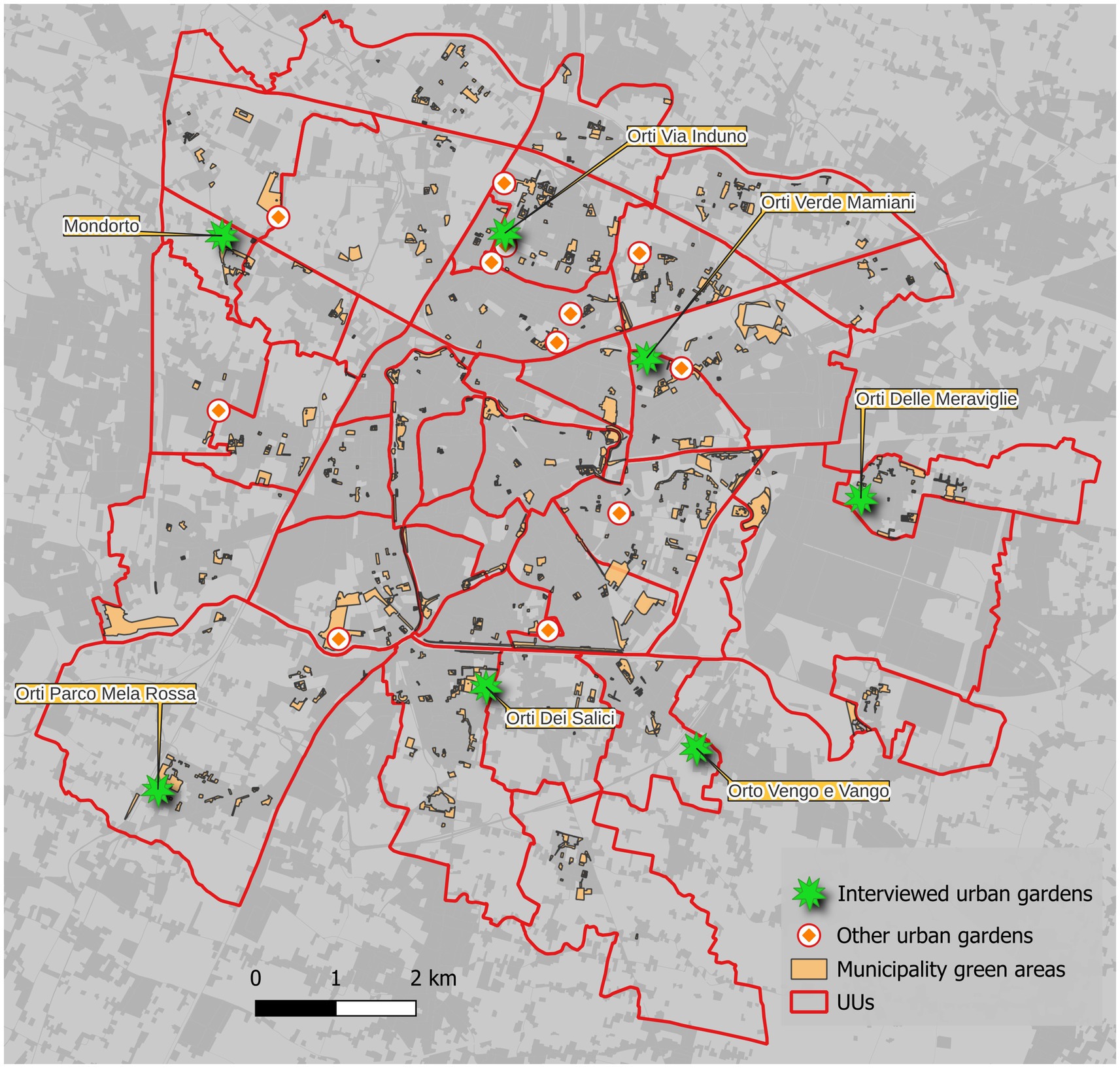
Figure 2. Spatial location of the 19 existing community gardens, categorized using different symbols that distinguish between the seven interviewed community gardens and the others. The map also reports the green areas of the municipality selected in the study.
The periodic calls for allocation have also seen a development in the types of target citizens, such as associations and schools, and not only individuals, as well as in aims, such as promoting the sharing of benefits, environmental education, and organic farming.
2 Materials and methods
Spatial and statistical data for Padua municipality were searched and collected, together with reports and publications concerning the topics of interest, to accomplish the aims of this study. Structured and semi-structured interviews were developed, tested, and carried out, and different sMCDA scenarios were created. Concerning the spatial dimension of community gardens’ locations, we considered two spatial scale levels that are useful for spatial planning purposes: the 40 UUs level and the green areas administrated by the municipality. In particular, for green areas, we used the spatial database provided by Padua municipality, which consists of over 12,000 polygons; the data were filtered by area size by considering only polygons over 500 m2 in size (considered the minimum area suitable for community garden creation) and selecting only categories that are useful for community gardens’ locations (e.g., excluding green areas inside roundabouts), obtaining a total of 476 areas.
2.1 Participatory survey and workflow
2.1.1 Interview definition and preparation
Two types of interviews were structured and carried out. First, semi-structured interviews were conducted with the community garden office staff of the municipality to obtain an overview of the state of the art of Padua community gardens and their histories as well as to select possible criteria for the sMCDA simulations on the basis of the respondents’ opinions, statistics, and the spatial data available. Second, structured interviews were carried out with the gardeners of the community gardens.
The structured interviews with the gardeners consisted of five parts. Sections 1 and 2 were related to the respondents’ personal data (i.e., age, residence, and employment) and general information (i.e., knowledge of the different kinds of community gardens in Padua and preferences for different typologies), while Section 3 investigated the habits of the users (i.e., how many times a week they visited their plots and how they reached them). The fourth section was about defining criteria, divided into two main categories (see Table 1), which were (i) distance features (six criteria), or the distance from some feature of interest (i.e., cycle paths and parking), and (ii) socioeconomic and cultural characteristics (hereafter social characteristics, with five criteria; i.e., number of families and presence of migrants). Finally, Section 5 included some questions to understand the people’s approval of community gardens (i.e., the surfaces of the lots, production, and services). The structured interview format was socialized and tested with the community garden office staff of the municipality.
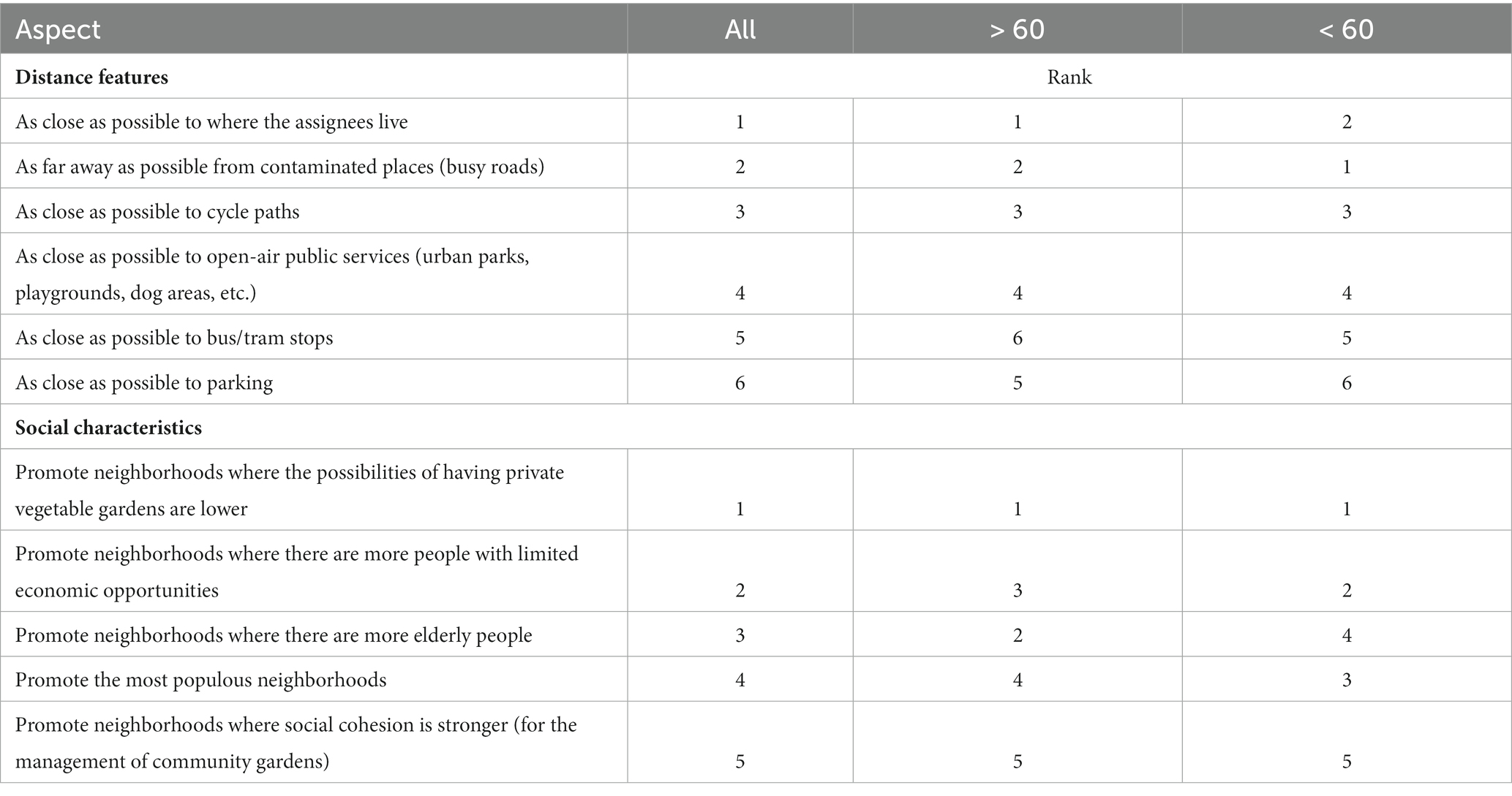
Table 1. Ranking of the key features and characteristics to consider for the selection of new areas for community gardens, divided into three macro categories.
2.1.2 Interview administration
In total, 7 of 19 representative community gardens were selected, and email and phone contacts were obtained with the support of the community garden office. The community gardens chosen were well distributed around the city and were located in different neighborhoods. Each representative was contacted to determine their availability for the study and to agree on a possible day for the interview. The selected sites were as follows (see Figure 2): Orti sociali di Via Induno (San Carlo community garden in the north of Padua), Orti delle Meraviglie (Camin community garden in the east of the city), Orti dei Salici (Guizza UU near the center of Padua), Orti del Parco Mela Rossa (in the southwest of the city), Orti Verde Mamiani (Stanga UU in the northeast of Padua), Orti Mondorto (Montà UU in the west of the city), and Orti Vengo e Vango (Voltabarozzo UU in the southeast of the city). Interviews were carried out between June 2023 and September 2023 in each community garden; the users verbally answered the questions shown to them in a paper interview, and their answers were registered simultaneously by the interviewer on the online version of the interview. In Section 4, in the part related to criteria assessment, laminated tags were prepared to increase interaction with the respondents; for each categoy, a color was chosen (green for distance features and yellow for social characteristics), and the interviewees were requested to order them, one category at a time, from the most important at the top to the least important at the bottom, according to their opinions. The final ranking was then recorded in the online system. Tags were blended every time to reduce the influence of the previous ranking.
2.2 The sMCDA approach and workflow
Multicriteria decision analysis refers to a series of approaches and techniques used to combine criteria of different types (e.g., social, environmental, and economic) in order to rank a series of alternatives for improving decision-making using a rational process that highlights better alternatives (Adem Esmail and Geneletti, 2018). The approach can be carried out using spatial criteria in a GIS environment to support territorial decision-making. Participation in MCDA is usually guaranteed by the definitions of the criteria, the preferences for them [i.e., an increase in the value of a criterion makes the alternative better (as a gain or benefit) or worse (as a cost)], and their relative weights, which express their relative importance for stakeholders. For this study, we used the TOPSIS approach in open-source QGIS software through the geoTOPSIS module of the vectorMCDA plugin (Massei, 2013).
The overall workflow is presented in Figure 3 and briefly explained here, following the typical MCDA steps. (1) Two types of alternatives, namely, the UUs (n = 40) and the selected municipality green areas (n = 476), were defined. (2) Meetings with key actors and spatial and available statistical data were used to select and create two types of criteria, which were distance from features of interest, such as cycle paths or residential buildings, and social criteria, such as density of families and percentage of private gardens per UU. (3) The decision-making geodatabase (i.e., the quantitative values of each criterion for each alternative were calculated for the UUs and green areas) was then created. (4) Two geoTOPSIS simulations were carried out using the relative weights between criteria derived from the interviews—one called distance index and the other social index. (5) Finally, a final geoTOPSIS simulation, which combined the two previous simulations using the same weights, was performed in order to obtain a final overall index. The criteria and their characteristics are presented in Table 2.
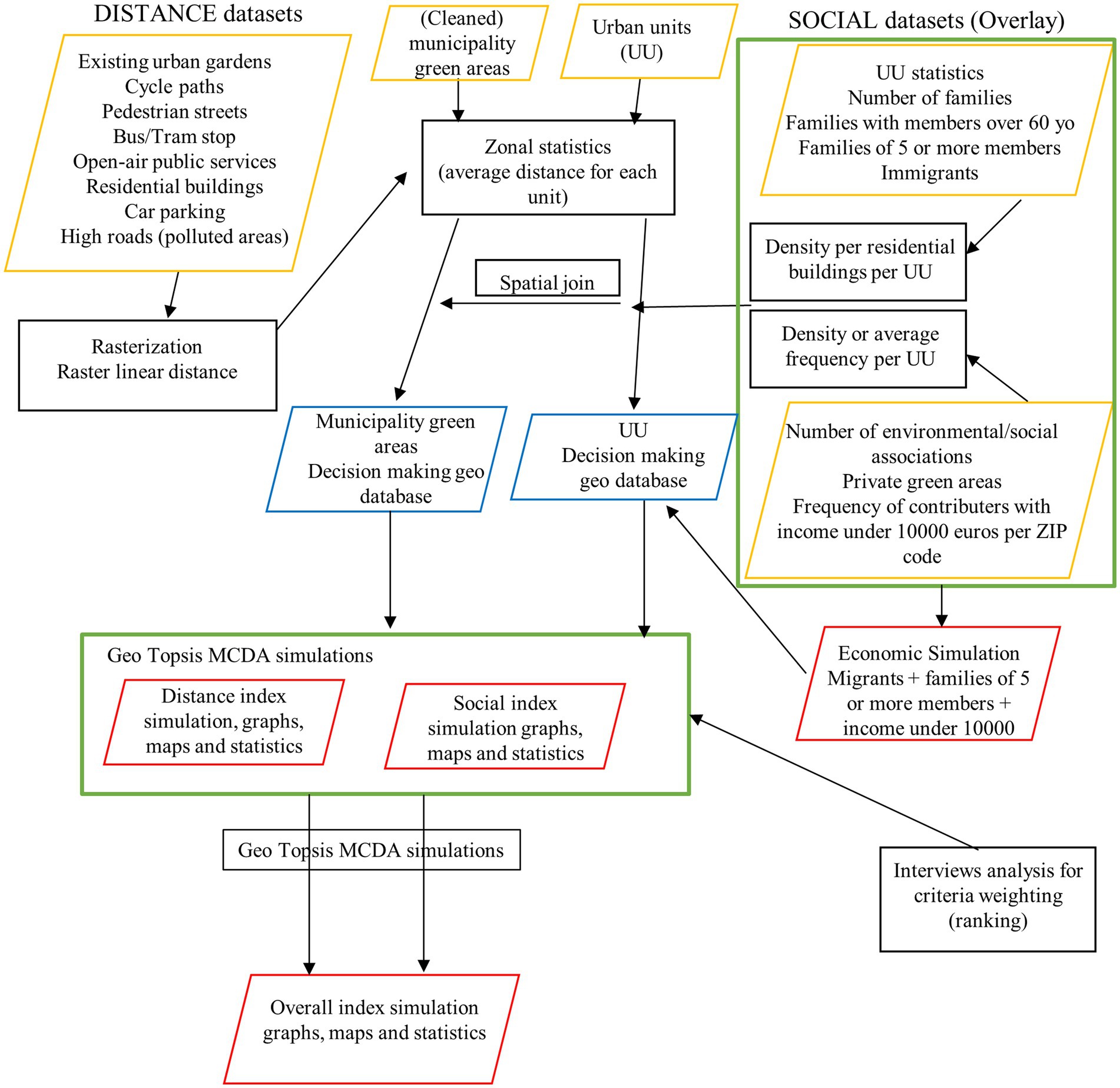
Figure 3. Workflow of the sMCDA analysis. Yellow boxes contain the main input dataset, black boxes contain the main geo-processing, blue boxes contain the intermediate output, and red boxes contain the final output.
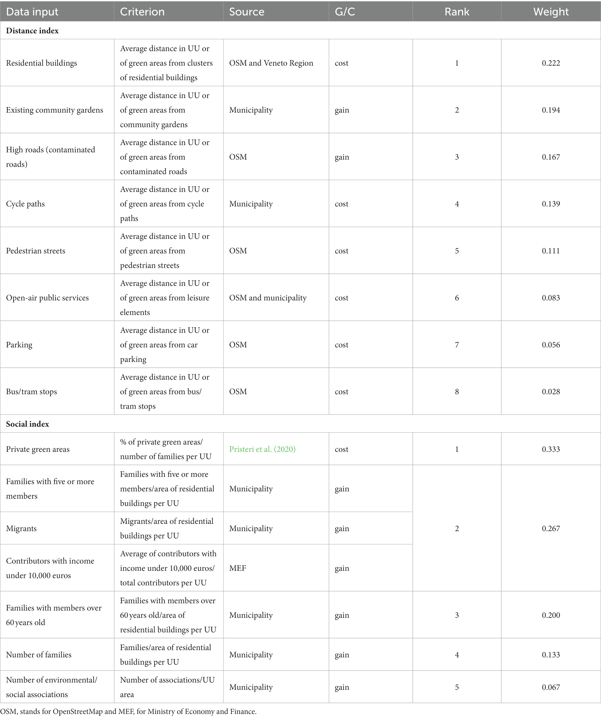
Table 2. Data input, criteria description, sources, preferences (cost or gain), ranks, and weights.
3 Results and discussion
3.1 Interviews with the community garden office staff of municipality and data collection
Interviews and data collection from the community garden office offer a general framework of the past and present situations of municipality community gardens and their localizations. Since the end of the 1990s, only some social (for people over 60 years old and low-income individuals) community gardens have been created; since 2021, with the advent of new municipality regulations and the creation of new areas, two public tenders (in 2021 and 2023) have included social and traditional (for every citizen of Padua over 18 years old) community gardens. Other types of community gardens (didactics and therapeutics) are listed in the regulation and derived from the example of past or current municipality or civil society association projects/experiences; however, they have never been implemented with continuity. Currently, the overall assignee compositions tend to be quite different between the two types (i.e., social and traditional community gardens). In social community gardens, almost all users are elderly Paduan citizens, as they are the main targets of this category, while in traditional community gardens, individuals over the age of 60 represent 75% of the total, and those in their 50s are the second most-represented group. The presence of migrants is quite frequent: 15% are non-European Union, but this percentage reaches 20% when considering also those coming from outside Italy. The proportion of male and female users is balanced, settling approximately 45% for females and 55% for males; this is due to the fact that most users manage the plots with the help of their families, often represented by their wives or husbands.
If a plot is unmanaged for a long time by the assignee, the municipality can rebuke the user, sending two warning letters reminding him/her to take care of the plot. If no change occurs, the plot assignment is revoked, the turnover procedure starts, and a new assignee is chosen from the current waiting list. It is worth noting that almost all users tend to give up spontaneously because of a lack of time or interest (94%); in a few cases, turnover is related to changes in the city of residence (1%) and health problems (5%), especially among the elderly. Based on the experiences of the community garden office staff, the best size of a community garden area is approximately 30 plots, considering financial and management issues. Additional plots usually present organizational problems or a decrease in social cohesion and participation, along with an increase in conflicts between users, whereas fewer plots usually present higher creation and maintenance costs.
The criteria used by the municipality for the allocation of new community gardens comprise spatial issues, such as proximity to other green areas, particularly urban parks, and to other services, such as sports centers. Moreover, community gardens should be preferred in highly populated neighborhoods, where water sources are available and connected to local municipal aqueducts, and where car parks, pedestrian ways, and cycle paths are located. Particular attention is given to those areas located in neighborhoods near the city center, where the demands are higher because of the lack of spaces to have one’s own vegetable garden, and new assignees are also chosen for their proximity to a community garden. However, no GIS spatialized or multicriteria analysis and/or the use of a participatory approach appears to be carried out to define siting, thereby limiting the analysis to the spatial knowledge of the city by decision-makers, the requests of citizens, or the number of people in the waiting list. Other more technical criteria are related to soil quality and fertility, which can be evaluated through on-site analyses.
3.2 Interviews with the community garden users
Interviews were conducted in seven community gardens (see the map in Figure 2) among the 19 existing in the municipality, for a total of 56 completed interviews. Of the respondents, 29% (n = 16) were female and 71% (n = 40) were male; 61% (n = 34) were over 60 years old, 39% (n = 22) were aged 30–60 years, and only one person was under 30 years old. Regarding education level, 5% (n = 3) had primary education, 64% (n = 36) graduated from secondary school, 27% (n = 15) graduated from university, and 4% (n = 2) had a master’s/PhD degree. In terms of employment, 54% (n = 30) of the respondents were retired, and only one person was unemployed. The majority of the interviewees were Italian citizens, while three were migrants. Dwellings were also considered: 20% (n = 11) lived in private houses, of which 82% (n = 8) had backyards, while 80% (n = 44) lived in flats, of which 35 had terraces.
Almost 95 and 79% of the interviewees knew of the existence of traditional and social gardens in Padua, respectively (Figure 4). These high percentages confirm the only two typologies of community gardens listed in the “Municipal Regulation for the Assignment and Management of Community Gardens” (Comune di Padova, 2019) that were put out to tender by the municipality. However, even if Padua does not manage other types of community gardens at present, most people pointed out the presence of didactic community gardens and gardens for associations (64 and 48%, respectively) as well as therapeutic and innovative gardens (21 and 26%, respectively); six individuals (10%) also mentioned food forests, a category not included in the municipal regulation. Based on some interviews, the mention of these typologies of community gardens is probably due to the interviewees’ knowledge of past or current garden or fruit tree projects carried out by the municipality or associations in some areas or with schools, besides the presence of some plots managed by associations. Among the desirable typologies (i.e., those that should be promoted/increased in Padua; each respondent could give a maximum of three answers. See Figure 4), the interviewees highlighted their interest in increasing traditional community gardens (64%) and their preferences for the didactic (50%) and therapeutic (41%) categories. This finding is consistent with that of Caneva et al. (2020), showing how community gardens, more recently, can also play an important role in environmental education to increase citizens’ awareness of biodiversity issues. It is important to highlight that these last two preferences show how citizens are also interested in cultural ES not directly related to food provision.
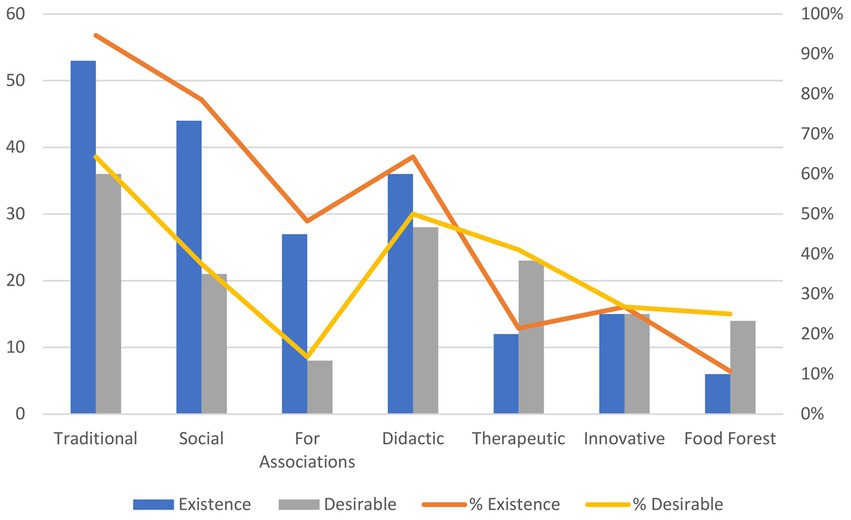
Figure 4. Graph showing the numbers (bars) and percentages (lines) of the answers to the questions (multiple choice) concerning the types of community gardens. The term “existence” relates to the question, “Which of these types of community gardens managed by Padua municipality exist in Padua?” The term “desirable” relates to the question, “Which of these types of community gardens should be promoted/increased in Padua?”.
The importance of cultural ES associated with community gardens is highlighted in Figure 5, which presents the question, “Why did you choose to cultivate a community garden.” Answers related to cultural ES, for example, “stay in nature/open air” and “cultivate the land” as a hobby, accounted for over 50% of the responses, while “cultivate relationships” accounted for 30%. Provisioning ES and food security, which can be associated with the answers “be autonomous in food production” and “economic advantage/save money,” both accounted for less than 10% of the total responses. Attention to the quality of food consumed (healthy food) was also a key focus, comprising 46% of the preferences. This finding is consistent with those of other works in other urban areas, such as Detroit (Newell et al., 2022). In the case of Padua, the interviewees represented mostly people living in flats or houses without gardens in a typical mid-sized city in a developed country or individuals who value having their own open spaces for the cultivation of their hobbies and for eating healthy food. However, some respondents underlined that cultivating their own food is not so economical compared with buying from discount markets, so they value more the production of their own handmade healthy food.
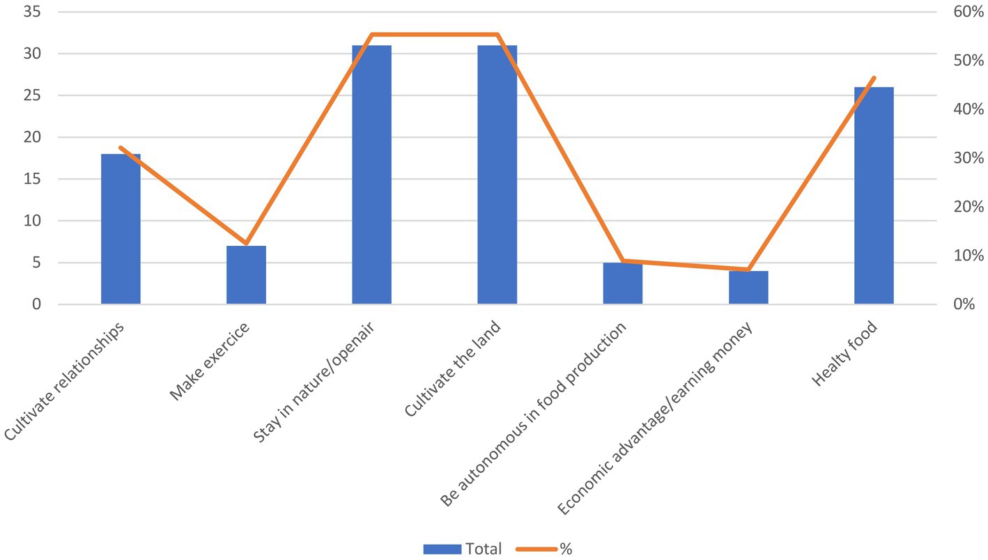
Figure 5. Graph showing the numbers (bars) and percentages (lines) of the answers to the question (multiple choice), “Why did you choose to cultivate a community garden?”.
Cultivating relationships is an important aspect confirmed by the graphs in Figures 6, 7. Figure 6 shows that 61% of the respondents worked on the plots with the help of relatives or friends, even if this help was occasional for 23% of them, while 39% worked without the support of family or friends; of the latter, 71% of the users were over 60 years old. It is worth noting that the municipal regulation allows the management of plots only at the family level, a limitation seen in a negative light by many gardeners, as they wish to have the right to involve whomever they want. Other than this, almost all interviewees agreed or strongly agreed that mutual help and sharing of work existed between gardeners, indicating that the community gardens are appropriate spaces to create new relationships and foster cooperation and mutual learning, as shown in Figure 7.
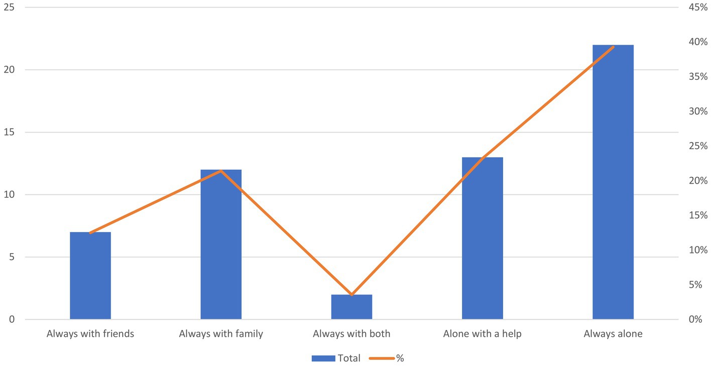
Figure 6. Graph showing the percentages of the answers to the question (multiple choice), “Who do you usually manage the plot with?”.
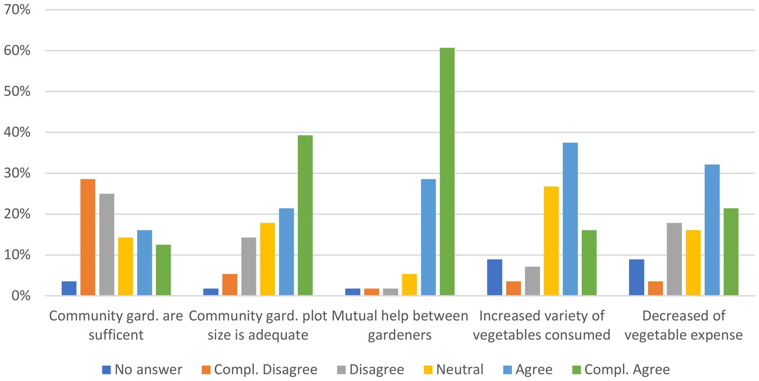
Figure 7. Graph of the answers (percentage) to different questions concerning the opinions of the gardeners about the key aspects regarding the use and management of community gardens.
The graphs in Figure 7 also present the opinions of the interviewees concerning the key aspects of the usefulness and adequacy of community gardens and their plots. More than 53% of the gardeners agreed that community gardens were not sufficient in the areas where they lived, which is evidenced by the number of requests for community gardens and the current waiting list. However, 29% believed that the number of community gardens was enough, perhaps due to the presence in each community garden of some plots that were abandoned or not well managed by their users. The opposite is the case with plot size (usually 30 m2), which was perceived as adequate by 60% of the respondents, even if some gardeners think that they should be at least 50 m2 in size to meet their families’ needs. This finding on plot size could confirm the lesser importance of community gardens for food security compared to other benefits, as perceived by the respondents. Some users’ answers to these two questions were interesting because they highlighted the need for a more flexible municipal regulation, particularly related to abandoned plots that should be reassigned quickly and/or should possibly be given to other gardeners in order to manage them while waiting for their new users. More than 50% of the users agreed that, due to the community gardens, they were able to increase the variety of vegetables they consumed, a finding that could be related to the importance they accord to healthy food consumption, and they were able to decrease their expenses for vegetable consumption.
The questions presented in Figure 8 and Table 1 are related to the definition of the criteria and weights for their uses in the sMCDA (Chapter 3.2). Figure 8 shows the results of two questions related to the distance and the means of transport used to reach the community garden; 73% of the interviewees lived within a distance of 2 km from the community gardens, and only 5% (3 users) had to travel more than 5 km. It is worth highlighting that most users who lived more than 3 km from the gardens were from one peripherical community garden (Orti delle Meraviglie, located in the east sector of Padua in a UU close to the industrial zone, with 62% of the interviewees living 3 km or more from the gardens). The users usually preferred to walk to the community gardens at a maximum distance of 2 km, but most of them (80% of the 15 respondents) were within a distance of 500 m or less. A bicycle is used mainly for a distance between 500 m and 4 km, a car is used mainly for 500 m or more, and it has become the most used means of transport starting from 3 km of distance. Some users use scooters or motorcycles, but none of them report using busses or trams. In general, sustainable means of transport (bike and walking) were the favorite choices to reach the community gardens, accounting for 58% of the answers, of which the percentage for bikes was 35%.
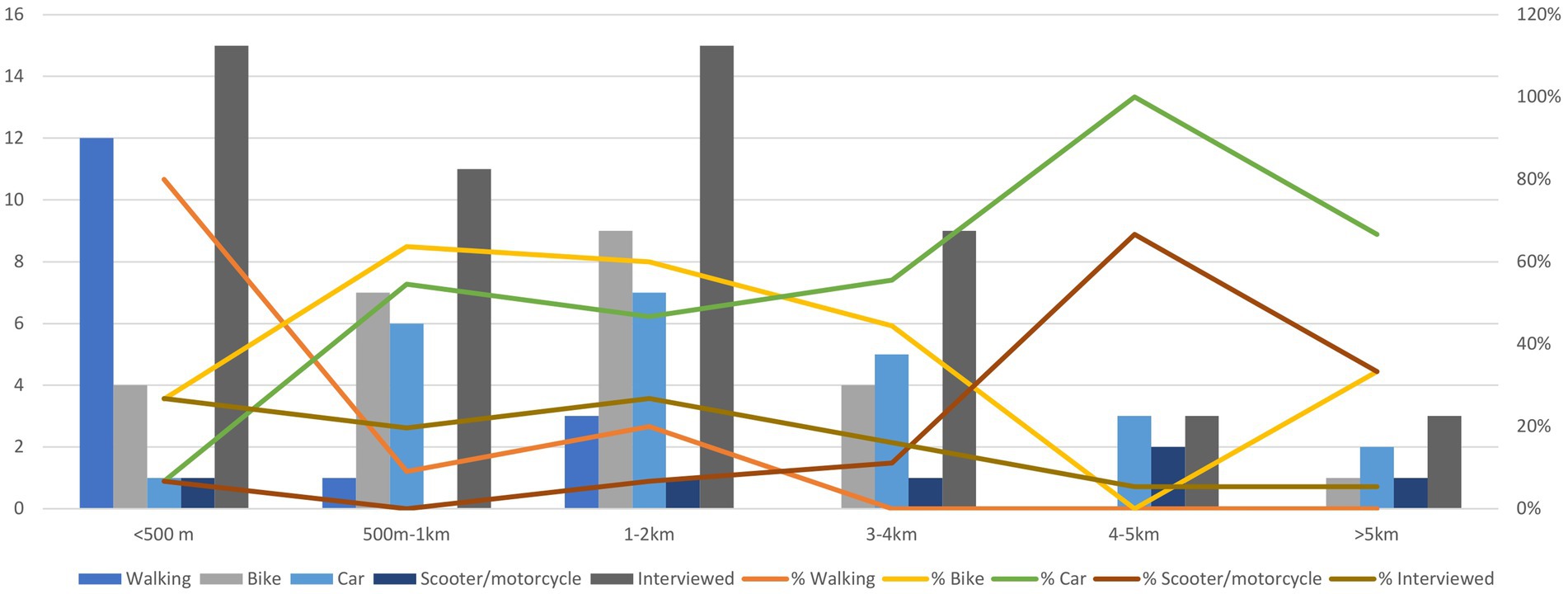
Figure 8. Graph showing the numbers (bars) and percentages (lines) of the answers to the question (multiple choice), “How do you usually reach the community gardens?” divided by the distances of the question, “How far is the community garden from your home?” (single choice). The bars and lines related to “interviewed” are the total respondents for each category.
Table 1 presents the ranking proposed by the interviewees regarding some key features and characteristics to consider in the selection of new areas where to create new community gardens. The ranking results are presented for all interviews and all respondents (all in Table 1), divided by those over 60 years old (>60 in Table 1) and those under 60 years old (<60 in Table 1). The interviewees strongly preferred community gardens located close to where the assignees live and, at the second place, the community gardens far from contaminated places. Closeness to cycle paths was at third place, and the presence of other public services near the community gardens was at fourth place. While the low rank of distance from bus/tram stops is not surprising, as none of the interviewees use these means of transport to reach the community gardens, the last rank of car parking is unexpected, considering the answers shown in Figure 8. Another group of features under the label social characteristics considers the social and economic features of possible assignees. The prioritization of areas with fewer opportunities of having private gardens is in the first place for all ages, followed by people with fewer economic opportunities. The presence of elderly people presents the main difference between those over 60 years old (at second place) and those under 60 (at fourth place). The population size of neighborhoods and social cohesion (i.e., the presence of associations that could manage the community gardens) had the lowest ranks.
3.3 Definitions of sMCDA criteria
The criteria and their weights used for the sMCDA simulations are presented in Table 2. The criteria types depend on the availability of spatial and statistical data, and their usefulness has emerged based on meetings with key actors. We also included most of the criteria already considered by the municipality (see section 3.1). The criteria ranking and weights mainly followed those in Table 1, with some modifications because of adjustments related to the other results that emerged from the interviews with the gardeners, the evaluation of the interviews with key actors, and data availability. The criteria were divided between the two simulations carried out concerning the distance index (distance from features of interest) and the social index (socioeconomic aspects derived from statistics at the UU level). For all respondents, the types and weights of the criteria for each simulation mainly correspond to the ranking in Table 1 (n = 56), with some adjustments; for the distance index, we added the criterion of distance from existing community gardens at second place because of its importance for the key informants of the municipality. We also considered distance from pedestrian streets after cycle paths because of the high number of people who access the community gardens by walking; we preferred to put car parking before bus/tram stops because of the extensive use of cars to reach the community gardens. For the social index, we split the aspect of limited economic opportunities into three, assigning the same weight (i.e., densities of families with five or more members, the presence of migrants, and contributors with an income under 10,000 euros), because they resulted in the best available data that represented this characteristic on the basis of a discussion with the key informants. It is worth noting that the preferences for the distance index criteria (G/C column of Table 2, where G stands for gain and C stands for cost) indicate the distance from benefit features as a cost, such as cycle paths or residential buildings, because the farther the feature is, the worse it is for the community garden.
3.4 sMCDA simulations
The following maps and tables of the sMCDA simulations at the UU and municipality green area levels allow for the visualization of the areas to be prioritized in the planning of new community gardens, according to the selected criteria and weights. The values of each area in the maps range from 0 (less suitable for new community gardens) to 1 (most suitable) and are presented with a graduated palette of seven classes (using a natural Jenks classification that maximizes the differences between groups), in which lighter colors correspond to lower values, and darker colors indicate higher values.
Figure 9 and Table 3 present the final maps at the UU level for the distance index, the social index, and the final overall index that combines the two previous scenarios, assigning the same weights, which means the same level of importance.
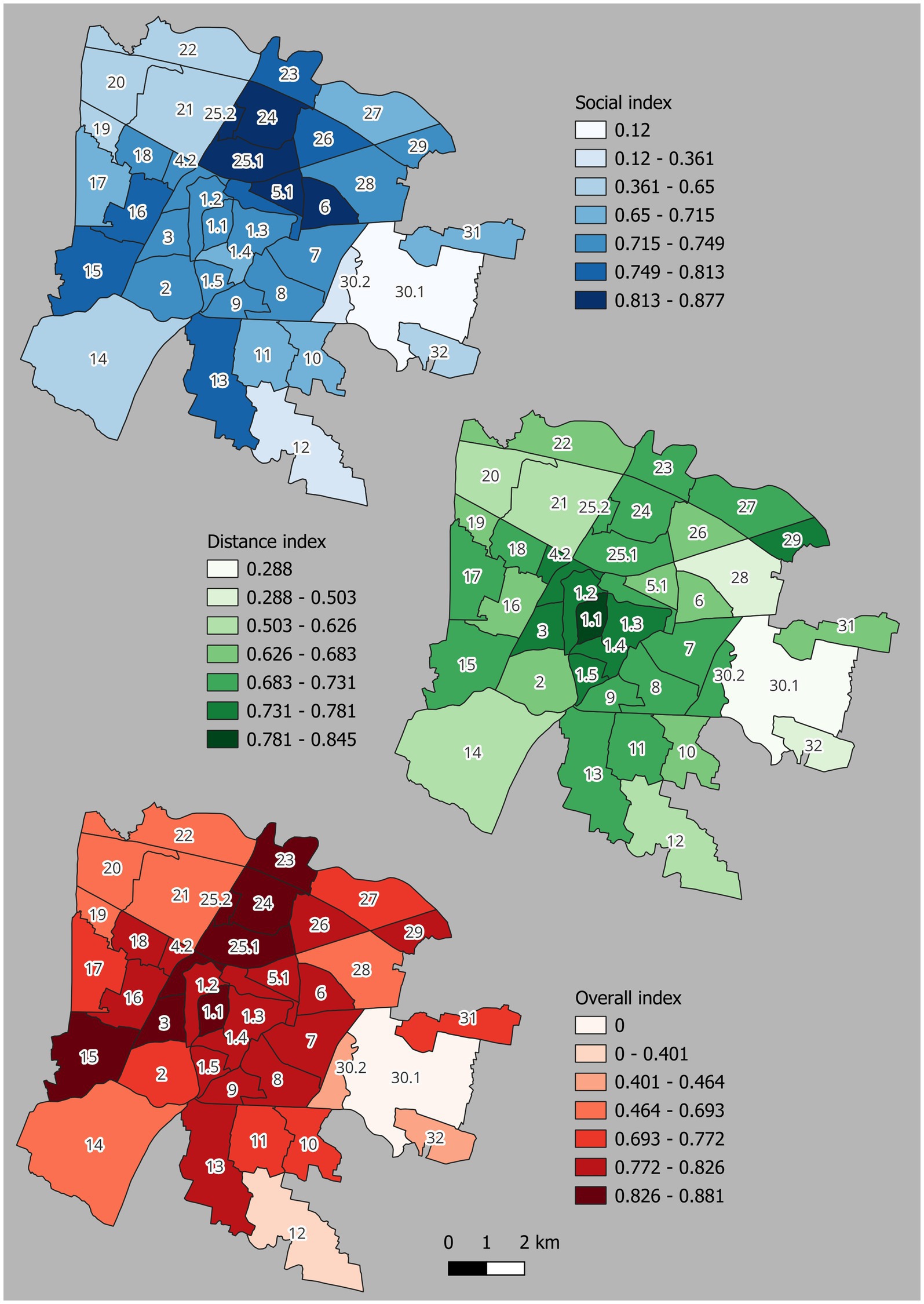
Figure 9. Maps of the results of the three sMCDA simulations carried out for the 40 UUs: the Social index, the distance index, and the combination of the two simulations (overall index).
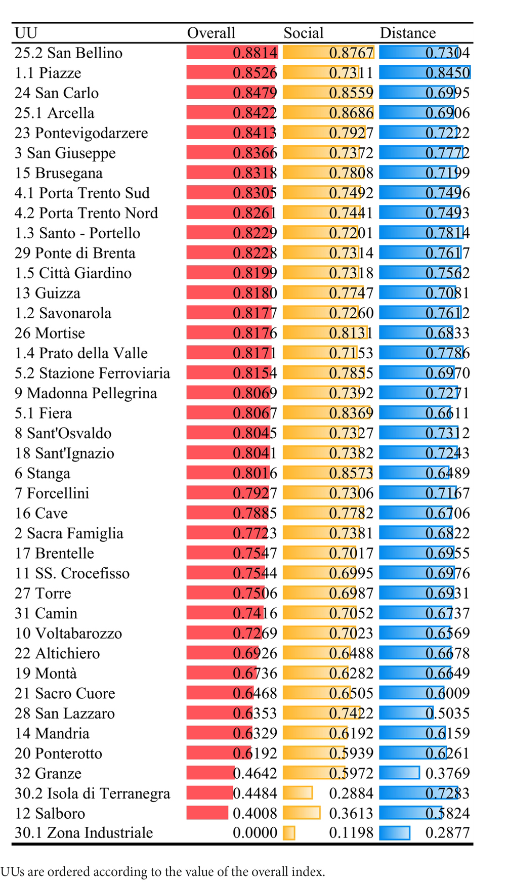
Table 3. Values of the 40 UUs according to the three MCDA simulations.
According to the social index, the UUs to be prioritized for new community gardens are mainly those in the north–northeast sector of Padua, which corresponds to Arcella (25.1), San Bellino (25.2), San Carlo (24), Fiera (5.1), and Stanga (6)—the areas in Padua with the highest density of migrants, families, and elder people and with a low presence of private green areas. The distance index privileges central UUs, particularly Piazze (1.1), Santo-Portello (1.3), Prato Della Valle (1.4), San Giuseppe (3), Savonarola (1.2), and Ponte di Brenta (29) in the extreme northeast sector. These results are attributed to the high average distances of existing community gardens, the low average distance of residential buildings, and the average closeness of cycle paths and other important public services, such as playgrounds or areas for dogs. The combination of the two simulations in the overall index shows a sort of dark red corridor of suitable UUs from the north–northeast to central–west, in which the contribution of the distance index is prominent in the central areas (such as for the Piazze UU, 1.1), while the social index influences the northern and western areas more. A less suitable UU for all simulations is the industrial area (30.1) in the east sector of the city because of the lack of most criteria considered as benefits. Overall, peri-urban areas, particularly those in the northwest, east, southwest, and southeast parts of Padua, present the lowest values because of their lowest service and population densities and the highest presence of private green areas.
Table 4 shows the number of municipality green areas considered in this study, such as urban parks, generic green, and playground areas, according to the categorization made by the green public office. For each category, the percentage of areas that fall under an index value, grouped by 0.x, is shown per simulation. As can be seen, most of the 476 areas are generic green (191), followed by urban parks (111) and school gardens (100), while there is a lower presence of playground areas (37) and other typologies. More than 60% of all categories score values from 0.8 to above for the overall index, while the areas are more distributed along the values for the social and distance indexes, even if, in general, most of them obtained scores over 0.7. For the social index, green areas show similar values for each UU because most criteria are derived from statistical data at the UU scale, while the green areas for the distance index present a sparser distribution because the values are influenced by distances from the features distributed all over the city, even if, in most cases, these features present a higher concentration in certain UUs as can be seen in Figure 9.
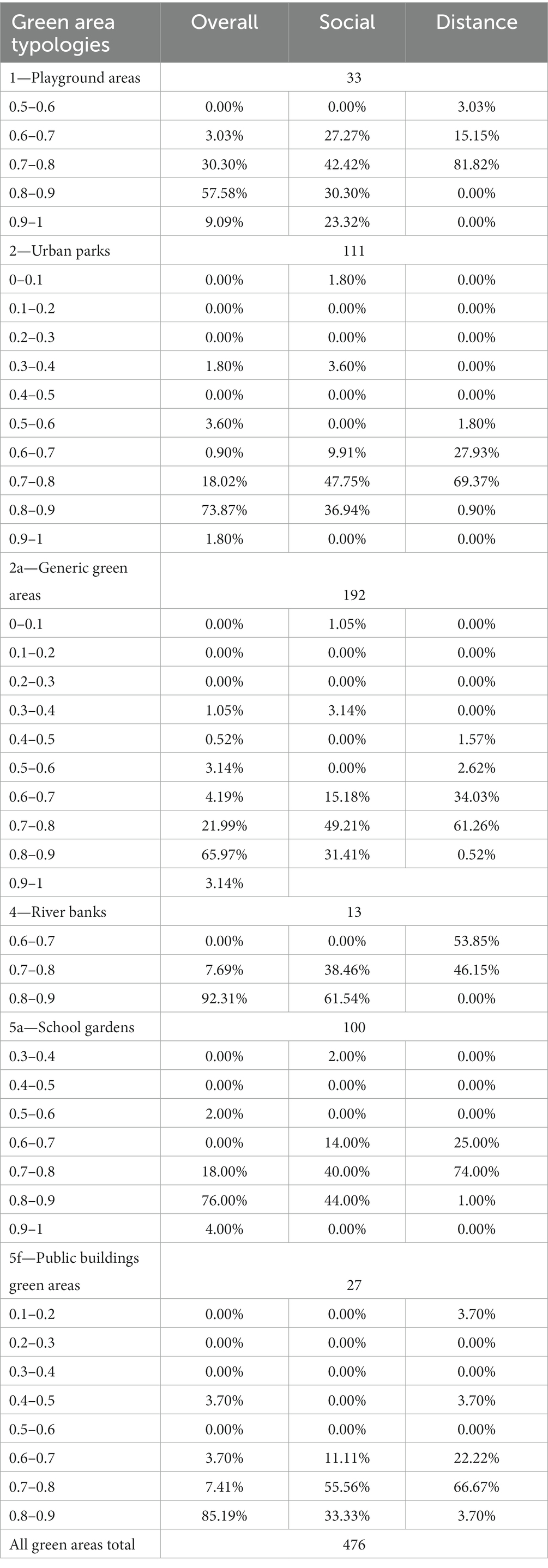
Table 4. Number of the different typologies of municipality green areas and their percentages for each sMCDA simulation value, grouped by 0.x.
The influence of the social index on the pattern of distribution of green areas on the overall index is visible in Figure 10, which shows the map of this final simulation, taking into consideration only urban parks (111 areas), which is the preferred category to implement community gardens according to the community garden municipality office. This figure also zooms in on two of the most suitable urban parks according to the simulation—one located in San Bellino and another located in San Carlo in the north sector of Padua.
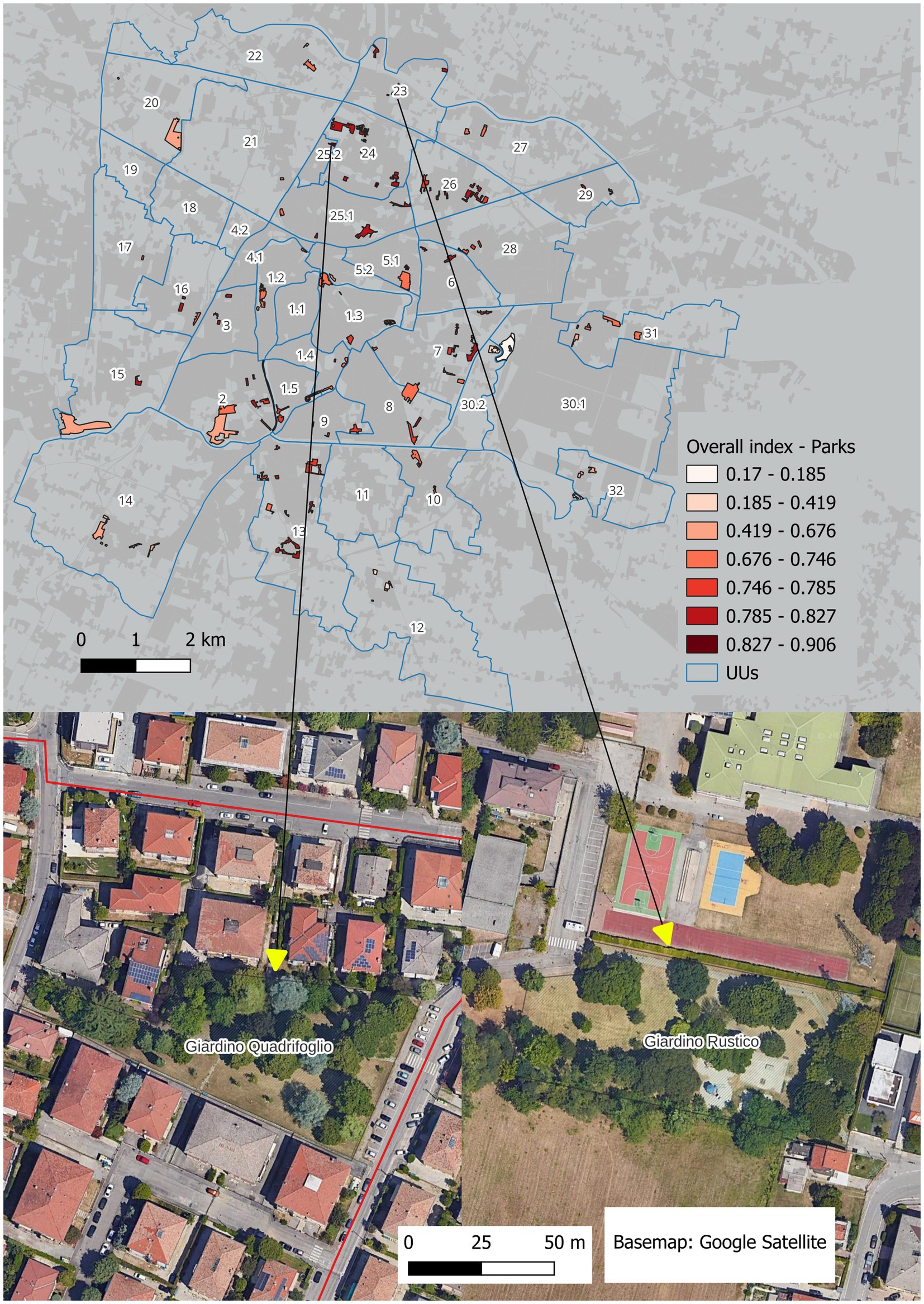
Figure 10. Map of the final sMCDA simulation (overall index) for the green municipality areas categorized as parks. Below is a zoomed image of two of the more ranked parks.
It is interesting to note that one of the most suitable UUs, namely, Piazze (1.1), lacks urban parks, so possible public interventions should consider the closest areas in the Savonarola (1.2) and Santo-Portello (1.3) UUs, which have middle values.
3.5 Participation and sMCDA as tools for improving sustainable urban planning
Our study proposes a transparent and systematic methodology to map community garden siting at two scale levels: the sub-urban division (UUs) and municipality green area levels. In this way, we tried to support the prioritization of different kinds of management areas for the introduction of new community gardens in Padua. This objective is accomplished through the implementation of a participatory methodology to obtain the final outcomes as a result of multistakeholder participation. Moreover, this study partially fills the gap in knowledge about community garden siting by testing the introduction of a stakeholder interview in the sMCDA. As reported by Smith et al. (2021), the sMCDA participatory approach is rarely applied in the identification and location of community gardens. Therefore, the methodology adopted is useful for synthesizing the different criteria that should be considered when localizing potential sites.
It is also important to highlight that the interviews revealed how the practitioners mainly value, apart from food security, the cultural ES that community gardens provide, including being in contact with nature, facilitating community gatherings, and strengthening social relations (Cumbers et al., 2018). These results are similar to those of previous studies, such as those of Turner et al. (2011), highlighting the importance of community gardens for social cohesion and the cultivation of relationships. In more detail, community gardens help practitioners form a denser network than that in their everyday lives (Glover, 2003) as well as help reduce isolation through the sharing of seeds, tools, knowledge, and ideas (Joshi and Wende, 2022). Additionally, our respondents recognized the benefits of this activity in terms of physical health and wellbeing (Koay and Dillon, 2020; Lampert et al., 2021).
These findings are informative for local policymakers and municipal agencies interested in implementing other community gardens in Padua. As seen in the interviews with the local office, the criteria used by the municipality to allocate new community gardens are mainly focused on spatial issues or proximity to other services, without applying any MCDA or participatory methodology. Informed by the responses in the practitioners’ interviews and the results of our analysis, this study could become an effective guide for future city policies regarding the siting of new community gardens.
Moreover, we believe that the methodology developed can be easily transferred to and applied in other cities to suggest community garden policy orientations and to integrate this topic into urban planning discourse. A coordinated planning process developed by the administration and strong community engagement could also involve more citizens, including younger ones, in the cultivation of community gardens.
Finally, as largely reported by the scientific literature, we also underline that the involvement of practitioners in surveys could foster the empowerment of citizens by increasing their awareness of specific issues, such as increasing urban agriculture in cities.
3.6 Limitations and future perspectives
The MCDA approach applied in this study enables the exploration of a quali-quantitative strategic methodology to inform the siting of community gardens in the city of Padua.
In this framework, additional research is needed, notably considering abandoned urban areas of the city as alternative and supplementary choices to the municipal green areas already investigated. According to Newell et al. (2022), localized community gardens on vacant or underutilized lands provide 2-fold benefits: (i) increasing the available areas for new community gardens in neighborhoods where the availability of municipal green areas is scarce and (ii) making productive use of abandoned spaces.
Future research could involve an increase in the size and diversification of the survey pool. More practitioners could be included in the survey by also involving the users of the 12 other community gardens already located in Padua. Furthermore, adding a pool of participants who are representative of migrants could obtain different results.
It is also important to highlight that future local regulations on community gardens should consider university students in the allocation of plots. Padua is considered a university city, hosting more than 70,000 students; however, most off-campus students do not change their residences, and they are not allowed to access community garden lists. The involvement of this category could be an important strategy to improve social cohesion among different categories of practitioners and could encourage social interactions across generations (Yotti Kingsley and Townsend, 2006).
Additional physical data and criteria could be implemented in subsequent steps of the MCDA process. Remote sensing data, such as high-resolution Digital Terrain and Surface Models coupled with vegetation indexes, could improve site selections by providing the real available green surface for each municipality area, so excluding buildings, trees, and paved elements. Other technical criteria, which should be directly evaluated by local policymakers, could include soil farming quality, soil contamination, slope steepness, and access to water. Moreover, soil testing should be highly considered if vacant or underused lands are included in order to avoid the presence of contaminants that, if ingested, could pose a health risk (McBride et al., 2014).
Finally, as reported by the scientific literature, the implementation of didactic and therapeutic community gardens can promote environmental education, in which both primary and secondary students are involved (Lloyd and Paige, 2022; Wood et al., 2022).
4 Conclusion
Community gardens are among the current and powerful strategies to re-introduce agriculture into urban contexts while also involving citizens and implementing green spaces in cities as well as improving quality of life of residents. In this study, we applied the sMCDA methodology to identify the neighborhoods to be prioritized when locating new community gardens in the city of Padua, Italy, through the direct involvement of practitioners in this choice. A survey was delivered to the users of 7 out of 19 community gardens located in the city.
The results identified neighborhoods to be prioritized in the planning of new community gardens according to three different scenarios: the distance index, the social index, and the combination of the two (overall index).
To conclude, this study highlighted the importance of adopting a decision-making methodology to support local policymakers and municipal agencies that are interested in implementing other community gardens in Padua. The case study and the methodology adopted could also be useful for other cities by providing step-by-step processes that can be directly applied.
Data availability statement
The original contributions presented in the study are included in the article/supplementary material, further inquiries can be directed to the corresponding author.
Ethics statement
Ethical review and approval was not required for the study on human participants in accordance with the local legislation and institutional requirements. Written informed consent from the patients/participants or patients/participants legal guardian/next of kin was not required to participate in this study in accordance with the national legislation and the institutional requirements.
Author contributions
DC: Conceptualization, Data curation, Formal analysis, Investigation, Methodology, Supervision, Visualization, Writing – original draft. DG: Formal analysis, Investigation, Methodology, Writing – original draft. FP: Conceptualization, Supervision, Validation, Visualization, Writing – original draft, Writing – review & editing.
Funding
The author(s) declare that no financial support was received for the research, authorship, and/or publication of this article.
Conflict of interest
The authors declare that the research was conducted in the absence of any commercial or financial relationships that could be construed as a potential conflict of interest.
Publisher’s note
All claims expressed in this article are solely those of the authors and do not necessarily represent those of their affiliated organizations, or those of the publisher, the editors and the reviewers. Any product that may be evaluated in this article, or claim that may be made by its manufacturer, is not guaranteed or endorsed by the publisher.
References
Adem Esmail, B., and Geneletti, D. (2018). Multi-criteria decision analysis for nature conservation: a review of 20 years of applications. Methods Ecol. Evol. 9, 42–53. doi: 10.1111/2041-210X.12899
Anguelovski, I., Connolly, J. J. T., Cole, H., Garcia-Lamarca, M., Triguero-Mas, M., Baró, F., et al. (2022). Green gentrification in European and north American cities. Nat. Commun. 13:3816. doi: 10.1038/S41467-022-31572-1
Bartolome, A. M., Carpio, D. A., and Urbano, B. (2022). Urban agriculture digital planning for the European Union’s green Deal. Amfiteatru Econ. 24, 159–172. doi: 10.24818/EA/2022/59/159
Bergstrom, J., Ready, R., Bergstrom, J., and Ready, R. (2009). What have we learned from over 20 years of farmland amenity valuation research in North America? Rev. Agric. Econ. 31, 21–49. doi: 10.1111/J.1467-9353.2008.01424.X
Bertram, C., and Rehdanz, K. (2015). The role of urban green space for human well-being. Ecol. Econ. 120, 139–152. doi: 10.1016/J.ECOLECON.2015.10.013
Bloem, S., and de Pee, S. (2017). Developing approaches to achieve adequate nutrition among urban populations requires an understanding of urban development. Glob. Food Sec. 12, 80–88. doi: 10.1016/J.GFS.2016.09.001
Boggia, A., Massei, G., Pace, E., Rocchi, L., Paolotti, L., and Attard, M. (2018). Spatial multicriteria analysis for sustainability assessment: a new model for decision making. Land Use Policy 71, 281–292. doi: 10.1016/J.LANDUSEPOL.2017.11.036
Bousquet, M., Kuller, M., Lacroix, S., and Vanrolleghem, P. A. (2023). A critical review of MCDA practices in planning of urban green spaces and NBS. Blue-Green Syst. 5, 200–219. doi: 10.2166/BGS.2023.132
Cabannes, Y., and Marocchino, C. (2018). Integrating food into urban planning. London, Rome: ULC Press, FAO
Caneva, G., Cicinelli, E., Scolastri, A., and Bartoli, F. (2020). Guidelines for urban community gardening: proposal of preliminary indicators for several ecosystem services (Rome, Italy). Urban Urban Green. 56:126866. doi: 10.1016/J.UFUG.2020.126866
Christensen, S., Malberg Dyg, P., and Allenberg, K. (2019). Urban community gardening, social capital, and “integration” – a mixed method exploration of urban “integration-gardening” in Copenhagen, Denmark. Local Environ. 24, 231–248. doi: 10.1080/13549839.2018.1561655
Cinelli, M., Kadziński, M., Gonzalez, M., and Słowiński, R. (2020). How to support the application of multiple criteria decision analysis? Let us start with a comprehensive taxonomy. Omega 96:102261. doi: 10.1016/J.OMEGA.2020.102261
Comune di Padova. (2019). Regolamento comunale per l'assegnazione e la gestione degli orti urbani. Available at: https://www.padovanet.it/sites/default/files/attachment/2019_11_25_Regolamento%20assegnazione%20e%20gestione%20orti%20urbani.pdf
Cumbers, A., Shaw, D., Crossan, J., and McMaster, R. (2018). The work of community gardens: reclaiming place for Community in the City. Work Employ. Soc. 32, 133–149. doi: 10.1177/0950017017695042
Comune di Padova. (2020). Padova 2030. Piano degli Interventi - Documento del Sindaco. Avaiable at: https://www.padovanet.it/urbanistica/NUOVO_PI/2020_12_21_DocumentoSindaco-signed.pdf
di Padova, C. (2021). La statistica per la città. Demografia del mese: ottobre 2021 Available at: https://www.padovanet.it/sites/default/files/attachment/Demo202110.pdf
di Padova, Comune. (2022). Il Piano del Verde del Comune di Padova. Premessa. Padova. Available at: http://www.padovanet.it/piano-del-verde-comunale/1_ALL-00_ColophonPremessa.pdf
Diehl, J. A., Sweeney, E., Wong, B., Sia, C. S., Yao, H., and Prabhudesai, M. (2020). Feeding cities: Singapore’s approach to land use planning for urban agriculture. Glob. Food Sec. 26:100377. doi: 10.1016/J.GFS.2020.100377
Fouilleux, E., Bricas, N., and Alpha, A. (2017). ‘Feeding 9 billion people’: global food security debates and the productionist trap. J. Eur. Publ. Policy 24, 1658–1677. doi: 10.1080/13501763.2017.1334084
Gittleman, M., Farmer, C. J. Q., Kremer, P., and McPhearson, T. (2017). Estimating stormwater runoff for community gardens in New York City. Urban Ecosyst. 20, 129–139. doi: 10.1007/S11252-016-0575-8/FIGURES/4
Glover, T. D. (2003). The story of the queen Anne memorial garden: resisting a dominant cultural narrative. J. Leis. Res. 35, 190–212. doi: 10.1080/00222216.2003.11949990
Goodman, W., and Minner, J. (2019). Will the urban agricultural revolution be vertical and soilless? A case study of controlled environment agriculture in New York City. Land Use Policy 83, 160–173. doi: 10.1016/J.LANDUSEPOL.2018.12.038
Harada, K., Hino, K., Iida, A., Yamazaki, T., Usui, H., Asami, Y., et al. (2021). How does urban farming benefit participants’ health? A case study of allotments and experience farms in Tokyo. Int. J. Environ. Res. Public Health 18, 1–13. doi: 10.3390/IJERPH18020542
Ilieva, R. T., Cohen, N., Israel, M., Specht, K., Fox-Kämper, R., Fargue-Lelièvre, A., et al. (2022). The socio-cultural benefits of urban agriculture: a review of the literature. Land 11:622. doi: 10.3390/LAND11050622
Joshi, N., and Wende, W. (2022). Physically apart but socially connected: lessons in social resilience from community gardening during the COVID-19 pandemic. Landsc. Urban Plan. 223:104418. doi: 10.1016/J.LANDURBPLAN.2022.104418
Kafle, A., Myers, B., Adhikari, R., Adhikari, S., Sanjel, P. K., Padhyoti, Y., et al. (2022). “Urban agriculture as a wellbeing approach and policy agenda for Nepal” in Natural resources and food security. Sustainable development goals series. eds. J. Timsina, T. N. Maraseni, D. Gauchan, J. Adhikari, and H. Ojha (Cham: Springer), 221–238.
Kingsley, J. Y., Townsend, M., and Henderson-Wilson, C. (2009). Cultivating health and wellbeing: members’ perceptions of the health benefits of a port Melbourne community garden. Leis. Stud. 28, 207–219. doi: 10.1080/02614360902769894
Koay, W. I., and Dillon, D. (2020). Community gardening: stress, well-being, and resilience potentials. Int. J. Environ. Res. Public Health 17, 1–31. doi: 10.3390/IJERPH17186740
Kyoi, S. (2023). Utilization of urban agriculture to enhance urban sustainability: investigating people’s heterogeneous preferences for proximity to urban agriculture through a choice experiment. Sustain. Sci. 18, 1851–1870. doi: 10.1007/S11625-022-01282-0/TABLES/9
Lampert, T., Costa, J., Santos, O., Sousa, J., Ribeiro, T., and Freire, E. (2021). Evidence on the contribution of community gardens to promote physical and mental health and well-being of non-institutionalized individuals: a systematic review. PLoS One 16:e0255621. doi: 10.1371/JOURNAL.PONE.0255621
Litt, J. S., Alaimo, K., Harrall, K. K., Hamman, R. F., Hébert, J. R., Hurley, T. G., et al. (2023). Effects of a community gardening intervention on diet, physical activity, and anthropometry outcomes in the USA (CAPS): an observer-blind, randomised controlled trial. Lancet Planet. Health 7, e23–e32. doi: 10.1016/S2542-5196(22)00303-5
Lloyd, D., and Paige, K. (2022). Learning science locally: community gardens and our future. Front. Educ. 7:850016. doi: 10.3389/FEDUC.2022.850016/BIBTEX
Massei, G. (2013). Geographic MCDA. Available at: http://maplab.alwaysdata.net/geomcda.html
Matteson, K. C., Ascher, J. S., and Langellotto, G. A. (2008). Bee richness and abundance in new York City urban gardens. Ann. Entomol. Soc. Am. 101, 140–150. doi: 10.1603/0013-8746(2008)101[140:BRAAIN]2.0.CO;2
McBride, M. B., Shayler, H. A., Spliethoff, H. M., Mitchell, R. G., Marquez-Bravo, L. G., Ferenz, G. S., et al. (2014). Concentrations of lead, cadmium and barium in urban garden-grown vegetables: the impact of soil variables. Environ. Pollut. 194, 254–261. doi: 10.1016/J.ENVPOL.2014.07.036
Mubvami, T., and Mushamba, S. (2006). Integration of agriculture in urban use planning. In R. Veenhuizenvan (Ed.), Cities farming for the future: Urban agriculture for green and productive cities (pp. 54–74). RUAF Foundation, IIRR, IDRC, Ottawa, Canada.
Munafò, M. (2022). Consumo di suolo, dinamiche territoriali e servizi ecosistemici. Edizione 2022. Report SNPA 32/22.
Newell, J. P., Foster, A., Borgman, M., and Meerow, S. (2022). Ecosystem services of urban agriculture and prospects for scaling up production: a study of Detroit. Cities 125:103664. doi: 10.1016/J.CITIES.2022.103664
Oda, K., Rupprecht, C. D. D., Tsuchiya, K., and McGreevy, S. R. (2018). Urban agriculture as a sustainability transition strategy for shrinking cities? Land use change trajectory as an obstacle in Kyoto City, Japan. Sustain. For. 10:1048. doi: 10.3390/SU10041048
Olsson, E. G. A., Kerselaers, E., Kristensen, L. S., Primdahl, J., Rogge, E., and Wästfelt, A. (2016). Peri-urban food production and its relation to urban resilience. Sustain. For. 8:1340. doi: 10.3390/SU8121340
Peroni, F., Choptiany, J., and Ledermann, S. (2022a). “Smart cities and agroecology: urban agriculture, proximity to food and urban ecosystem services” in Drones and geographical information Technologies in Agroecology and Organic Farming: Contributions to technological sovereignty (United States: CRC Press), 204–223.
Peroni, F., Pappalardo, S. E., Facchinelli, F., Crescini, E., Munafò, M., Hodgson, M. E., et al. (2022b). How to map soil sealing, land take and impervious surfaces? A systematic review. Environ. Res. Lett. 17:053005. doi: 10.1088/1748-9326/AC6887
Pristeri, G., Peroni, F., Pappalardo, S. E., Codato, D., Castaldo, A. G., Masi, A., et al. (2020). Mapping and assessing soil sealing in Padua municipality through biotope area factor index. Sustain. For. 12:5167. doi: 10.3390/SU12125167
Pristeri, G., Peroni, F., Pappalardo, S. E., Codato, D., Masi, A., and De Marchi, M. (2021). Whose urban green? Mapping and classifying public and private green spaces in Padua for spatial planning policies. ISPRS Int. J. Geo Inf. 10:538. doi: 10.3390/IJGI10080538
Romanovska, L., Osmond, P., Oldfield, P., Ladan, T. A., Ibrahim, M. H., Ali, S. S. B. S., et al. (2022). A geographical review of urban farming and urban heat island in developing countries. IOP Conf. Ser.: Earth Environ. Sci. 986:012071. doi: 10.1088/1755-1315/986/1/012071
Sanyé-Mengual, E., Specht, K., Krikser, T., Vanni, C., Pennisi, G., Orsini, F., et al. (2018). Social acceptance and perceived ecosystem services of urban agriculture in southern Europe: the case of Bologna, Italy. PLoS One 13:e0200993. doi: 10.1371/JOURNAL.PONE.0200993
Siegner, A., Sowerwine, J., and Acey, C. (2018). Does urban agriculture improve food security? Examining the Nexus of food access and distribution of urban produced foods in the United States: a systematic review. Sustain. For. 10:2988. doi: 10.3390/su10092988
Smith, R. J., Houtman, J., and Stwalley, R. M. (2017). A site suitability approach to sustainable urban agriculture using GIS and decision analysis. ASABE Annual Inter. Meet. 1701615. doi: 10.13031/AIM.201701615
Smith, J. P., Meerow, S., and Turner, B. L. (2021). Planning urban community gardens strategically through multicriteria decision analysis. Urban For. Urban Green. 58:126897. doi: 10.1016/J.UFUG.2020.126897
Turner, B., Henryks, J., and Pearson, D. (2011). Community gardens: sustainability, health and inclusion in the city. Local Environ. 16, 489–492. doi: 10.1080/13549839.2011.595901
Wood, C. J., Barton, J. L., and Wicks, C. L. (2022). The impact of therapeutic community gardening on the wellbeing, loneliness, and life satisfaction of individuals with mental illness. Int. J. Environ. Res. Public Health 19:13166. doi: 10.3390/IJERPH192013166
Worldwatch Institute. (2011). The state of the world 2011: Innovations that nourish the planet. Washington, Routledge.
Yotti Kingsley, J., and Townsend, M. (2006). ‘Dig in’ to social capital: community gardens as mechanisms for growing urban social connectedness. Urban Policy Res. 24, 525–537. doi: 10.1080/08111140601035200
Keywords: urban agriculture, community gardens, participation, urban ecosystem services, spatial multicriteria decision analysis, MCDA, GIS, urban planning
Citation: Codato D, Grego D and Peroni F (2024) Community gardens for inclusive urban planning in Padua (Italy): implementing a participatory spatial multicriteria decision-making analysis to explore the social meanings of urban agriculture. Front. Sustain. Food Syst. 8:1344034. doi: 10.3389/fsufs.2024.1344034
Edited by:
Diego Griffon, Central University of Venezuela, VenezuelaReviewed by:
José Renato De Nóbrega Suárez, Central University of Venezuela, VenezuelaSyam Viswanath, Kerala Forest Research Institute, India
Copyright © 2024 Codato, Grego and Peroni. This is an open-access article distributed under the terms of the Creative Commons Attribution License (CC BY). The use, distribution or reproduction in other forums is permitted, provided the original author(s) and the copyright owner(s) are credited and that the original publication in this journal is cited, in accordance with accepted academic practice. No use, distribution or reproduction is permitted which does not comply with these terms.
*Correspondence: Daniele Codato, daniele.codato@unipd.it
†These authors have contributed equally to this work