Geological Disasters in Deep Engineering Mechanism, Warning and Risk mitigation

163kviews
Editorial09 May 2023
Editorial: Geological disasters in deep engineering: mechanism, warning and risk mitigation

With the increasing demand for infrastructure construction as the global economy progresses, the need for exploration and utilization of deep underground space becomes more crucial. Various deep underground projects are planned, are under construction, and have been built to encounter great construction challenges due to the complex geo-environment such as strong tectonic movement, fragile geoenvironment and complex thermo-hydro-mechanical-chemical conditions. These deep engineering projects could be endangered by different kinds of geological disasters, such as intense rockburst, large deformation, strong water inrush, and large-scale collapse, which might result in massive loss of life and economic damage during the construction of deep underground projects.Efforts are being called for strengthening science and technology innovation and cooperation in geological disaster mitigation and sustainable development during the construction of deep engineering projects. To mitigate the risk of geological disaster in deep engineering under the complicate geo-environment, the mechanism of the formation and evolution of geological disasters in deep engineering needs to be understood. The testing, monitoring, simulation, risk assessment and early warning methods for geological disaster in deep engineering are also needed urgently. New theories, methods and techniques related to the mechanism, warning and risk mitigation of geological disasters in deep engineering will be extremely helpful for the construction safety of deep engineering.

In order to attract scholars' attention to geological disasters in deep engineering, the current Research Topic 'Geological Disasters in Deep Engineering: Mechanism, Warning and Risk Mitigation' was organized. This Research Topic has an overarching focus on new theories, methods and techniques that have been developed to reveal the mechanism and to warn and mitigate the risk of geological disasters in deep engineering. There are 38 papers in this Research Topic with 210 authors. According to the main content of these papers and the Research Topic, I summarized and divided the papers into three parts and 10 papers were selected to show as an example.

Recognition of the characteristics, laws, and mechanisms of geological disasters in deep engineering is the basis for reasonable evaluation, warning, and control of them.

In order to study and reveal the formation mechanism of geological hazards in deep engineering and provide a warning, a series of monitoring and analysis

Risk assessment and warning methods for geological hazards in deep engineering are the basis for specifying prevention strategies and adopting reasonable prevention measures, as well as the prerequisite for avoiding risks and ensuring the smooth implementation of deep engineering. Guo et al. proposed a method that takes into account the in-situ stress, rock mass integrity, span length, and depth of highly damaged zone to determine the excavation damage zone in underground engineering. Wei et al. developed a hybrid model based on information entropy and unascertained measurement incorporating four membership functions to evaluate the tunnel squeezing, which is able to enrich the available risk evaluation methods for deep underground excavation projects.

Research on evolution mechanism, warning, and risk mitigation of disasters in deep engineering in different fields, such as water conservancy and hydropower, transportation, national defense, and deep basic physics laboratories, is a major topic in engineering construction and operation. The failure characteristics of rockmass in deep engineering are significantly different from those in shallow engineering, posing a huge challenge to the research on rock mechanical properties and disaster mechanism recognition, warning and analysis theory, and risk mitigation. There are various types of disasters in deep engineering, such as rockburst, deformation, water intrusion, collapse, et al. A rockburst is defined as damage to an excavation that occurs in a sudden or violent manner and is associated with a seismic event. The author of this Editorial is mainly engaged in research on the mechanism, monitoring, warning, and control of rockburst in deep engineering. Here, several suggestions on rockburst for future research are given as an example.Considerable progress has been made in the study of rockburst development process. It includes the characteristics, types, induced effects of construction methods, mechanisms, testing and observation monitoring methods, as well as the theory and technology of rockburst warning and risk mtigation.

Currently, a systematic indoor and on-site comprehensive observation and monitoring technology for rockburst in deep engineering has been established. The mechanism of rockburst development in deep engineering was revealed to a certain extent. A deeper understanding of the mechanism of immediate rockburst was obtained. However, the monitoring technology and mechanism of time-delay rockburst and intermittent rockburst in deep engineering still need further research.

The author of this Editorial has conducted a large amount of research on the warning of immediate rockburst in deep engineering and proposed a real-time quantitative warning method for rockburst in deep tunnel. Rockburst warning has been changed from qualitative to quantitative through the method. The method has been tested and applied in a large number of deep engineering projects. However, there is still a lack of effective warning methods for time-delay, intermittent, and fault slip rockbursts.

2,351 views

1 citations

ORIGINAL RESEARCH
17 January 2023
Research on prevention and control methods of land subsidence induced by groundwater overexploitation based on three-dimensional fluid solid coupling model—a case study of Guangrao County
Peijie Yang, 3 more and Yue Yao
Research on prevention and control methods of land subsidence induced by groundwater overexploitation based on three-dimensional fluid solid coupling model—a case study of Guangrao County
Land subsidence is an environmental geological phenomenon with slowly decreasing ground elevation, The North China Plain is one of the areas with the most serious land subsidence in China, and Guangrao County is one of the subsidence centers. This paper is based on the hydrogeological and engineering geological data of Guangrao County, the groundwater monitoring data for many years and the land subsidence monitoring data, systematically analyzes the dynamic characteristics of groundwater, the distribution and evolution of land subsidence, and the correlation between groundwater exploitation and land subsidence development in different layers of this area. Based on Biot porous medium consolidation theory, establishes a three-dimensional fluid solid coupling numerical model of land subsidence in Guangrao County, restores the development process of land subsidence, predicts and analyzes the subsidence evolution law under different groundwater exploitation schemes, and proposes targeted prevention and control measures. The research results show that: the shallow groundwater forms a cone of depression with Guangbei Salt Field as the center, and the deep groundwater forms an elliptical regional cone of depression with the urban area as the center. The ground is gradually formed two small settlement areas with the urban area of Guangrao County and Guangbei Salt Field as the settlement center, and there is a trend of interrelated expansion. The three-dimensional fluid solid coupling model of land subsidence accurately restored the development process of land subsidence in the study area, predicted that under the current groundwater exploitation conditions, by 2040, the settlement of Guangrao urban settlement center will increase to 1350 millimeters, forming a large regional funnel centered around the urban area, and gradually developing and expanding around. Prohibition of groundwater exploitation in the main funnel area is a more reasonable and effective exploitation plan to prevent the development of land subsidence.

4,242 views

8 citations

ORIGINAL RESEARCH
16 January 2023
Analysis of geothermal potential in Hangjiahu area based on remote sensing and geographic information system
Linxia Xu, 7 more and Chenghao Hu
Analysis of geothermal potential in Hangjiahu area based on remote sensing and geographic information system
Geothermal resources are one of the most valuable renewable energy sources because of their stability, reliability, cleanliness, safety and abundant reserves. Efficient and economical remote sensing and GIS technology has high practical value in geothermal resources exploration. However, different study areas have different geothermal formation mechanisms. In the process of establishing the model, which factors are used to model and how to quantify the factors reasonably is still a problem that needs analysis and study. Taking Hangjiahu area of Zhejiang Province as an example, based on geothermal exploration and remote sensing interpretation data, this paper evaluates the correlation between the existing geothermal hot spots and geothermal related factors such as lithology, fault zone distance, surface water system and its distance, seismic point distance, magmatic rock and volcanic rock distance, surface water, farmland, woodland temperature and so on. The relationship between geothermal potential and distribution characteristics of surface thermal environment, fault activity, surface water system and other factors is explored. AHP analytic hierarchy process and BP neural network are used to establish geothermal potential target evaluation models. Using geothermal exploration model, the potential geothermal areas of Hangjiahu Plain are divided into five grades, and most geothermal drilling sites are distributed in extremely high potential areas and high potential areas. The results show that using remote sensing interpretation data and GIS analysis data, it is feasible to analyze geothermal potential targets based on AHP analytic hierarchy process and BP neural network, and the distribution characteristics of surface thermal environment, fault activity, surface water system and other related factors are also related to geothermal distribution. The prediction results of the model coincide with the existing geothermal drilling sites, which provides a new idea for geothermal exploration.

3,199 views

12 citations

Resilient city is an ideal goal and model of urban development proposed in response to today’s complex and dynamic environmental changes. In this study, a resilient city evaluation framework composed of “social resilience-economic resilience-urban infrastructure and service-urban governance” was built on the basis of the multi-dimensionality of the urban system; the entropy weight method was used to measure the level of urban resilience in Hunan Province, while an obstacle degree model was used to identify any obstacle factor restricting the development of resilience. The results show that the urban resilience level of Hunan Province has grown slowly over the past 10 years, and there is an obvious regional difference in urban resilience level. There are more and more highly resilient cities, but low and medium-resilience cities still dominate the province, forming a spatial process of evolution from “medium and high-level dispersion” to “medium and high-level aggregation” in the Changsha-Zhuzhou-Xiangtan Urban Agglomeration. The level of urban resilience is predominantly hindered by the social and economic systems; at the index layer, most obstacle factors exist from the economic system to the social-economic-urban infrastructure and service system.

3,340 views

13 citations

ORIGINAL RESEARCH
10 January 2023
Study on critical slowdown characteristics and early warning model of damage evolution of sandstone under freeze–thaw cycles
Jiaxu Jin, 3 more and Shaohua Li
Study on critical slowdown characteristics and early warning model of damage evolution of sandstone under freeze–thaw cycles
Freeze–thaw damage of rock mass poses a great threat to the safety of rock engineering, ground buildings, and low-temperature storage of liquefied natural gas (LNG) in cold regions. By collecting acoustic emission (AE) signals of sandstone during uniaxial compression failures, this paper analyzed the critical slowdown phenomenon of different types of sandstone during the freeze–thaw failure. According to the auto-correlation coefficients and the variance of AE signals under different windows and steps, the precursors were determined and a warning model of rock engineering failure precursors based on the critical slowdown principle was proposed. Then the Grey Wolf Optimizer (GWO) algorithm was used to optimize the initial weights and thresholds of the back propagation (BP) neural network, and the influence factors of rock engineering failure under different working conditions were input as training sets to train the network. The results showed that the correlation coefficients between the predicted value and real value of the GWO-BP neural network reached 99.90 % and 98.81 % respectively, indicating that the accuracy of the BP neural network prediction was improved. This study provides a new method for rock engineering failure early warning, and has great theoretical and guiding significance for enriching and improving the rock mass AE monitoring technology.

2,588 views

16 citations

ORIGINAL RESEARCH
5 January 2023
With the increasing size of open caissons in large-span bridge projects, the overall settlement of giant open caissons is vital to the safe construction of bridge superstructures. Taking the Changtai Yangtze River Bridge as the engineering case, the overall deformation of the open caisson was studied during the construction stage of this bridge superstructures. First, the theoretical layerwise summation method was utilized to analyze the settlement of the open caisson. Then, a 3-D finite element model was established to simulate the installation stage of the bridge superstructure. Finally, a large centrifuge model test was performed to obtain the deformation of the open caisson at each step of bridge construction. The results of the abovementioned approaches demonstrated that final settlements were quite consistent, which was approximately 225 mm when the bridge superstructure was completely installed, and the settlement deformation curve could be divided into three stages: slowly increasing, rapid and becoming stable. This study can provide significant guidance for the construction of the Changtai Yangtze River Bridge and referential value to similar open caisson engineering projects throughout the world.
Settlement analysis of the giant open caisson during the construction of the Changtai Yangtze River Bridge

3,506 views

9 citations

Mechanical characteristics analysis of horizontal lifting of subsea pipeline with different burial depths
ORIGINAL RESEARCH
19 September 2022
Mechanical characteristics analysis of horizontal lifting of subsea pipeline with different burial depths
Dapeng Zhang, 1 more and Keqiang Zhu
With the consideration of the soil resistance to subsea pipelines, combined with the specific sea condition parameters of a certain sea area, and based on the lumped mass method, the subsea pipeline is discretized into a lumped mass model, the dynamic analysis model of three-point horizontal lifting of subsea pipelines with different burial depths is established, the stress and bending of the pipelines with different burial depths are analyzed, and the calculation results with different burial depths are compared and analyzed. The variation of mechanical characteristics of the process of lifting horizontal pipelines with different buried depths is obtained. The results show that the change of burial depth has a significant influence on the effective tension of the pipeline. With the increase of the burial depth, the maximum degree of stretching of the pipeline first decreases and then increases. Within a certain depth range, burying the pipeline in the seabed can reduce both the effective tension and the intensity of the fluctuation of the effective tension when the pipeline is lifted. The change of burial depth for the change of shear action is mainly reflected in the change of the numerical value of the shear force, and has no significant impact on the degree and variation fluctuation of the shear force. The conclusions can provide certain theoretical reference for the design of the process of the horizontal pipeline lifting.

3,189 views

10 citations

Frequency spectrum and energy refinement characteristics of blasting vibration signals in raw water pipeline tunnel excavation
ORIGINAL RESEARCH
22 August 2022
Frequency spectrum and energy refinement characteristics of blasting vibration signals in raw water pipeline tunnel excavation
Liang Zhang, 2 more and Zongwei Deng
The analysis of time-frequency variation and energy refinement characteristics of blasting vibration signals has contributed to understanding the propagation law of blasting vibration wave and reducing the possible losses. Combined with the measured data of tunnel blasting excavation and based on the newly constructed wavelet function, the spectrum distribution and energy refinement characteristics of tunnel blasting vibration signals are deeply explored and studied. The results demonstrated that compared to the Fourier spectrum, the innovative method of scale energy spectrum can not only acquire the dominant frequency of the blasting vibration signals, but also the obtained spectrum curve is smoother and can clearly reflect the change trend of the signal spectrum. The newly constructed biorthogonal wavelet has the characteristics of high vanishing moment, high regularity and matching with the waveform variation of the measured blasting vibration signals, and can describe the subtle variation characteristics of blasting vibration signal frequency. The continuous wavelet transform energy spectrum can reflect the three-dimensional energy distribution of blasting vibration signal in the time-scale domain, and the occurrence time of frequency, the frequency duration interval and time range of blasting vibration signal can also be acquired. Wavelet packet algorithm can precisely calculate the energy distribution of each frequency component in the signal, the tunnel blasting vibration signals (YBJ1, YBJ2) generated near the power tower presents low frequency, while the signals (YBF3,YBF4) far away from the power tower presents relatively high frequency. Measures should be taken to control the vibration and resonance of power tower caused by tunnel blasting. This research is of great significance for recognizing the propagation law of vibration waves, reducing the impact of blasting on surrounding buildings, and ensuring the safety of tunnel construction and surrounding buildings.

3,319 views

5 citations

ORIGINAL RESEARCH
23 August 2022
Study on anti-collision behavior of new precast concrete curb components in a highway tunnel
Changjun Li, 5 more and Man Wang

2,375 views

Deformation and Failure Characteristics of Loading and Unloading Rock Based on Volume Crack Strain
ORIGINAL RESEARCH
15 August 2022
Deformation and Failure Characteristics of Loading and Unloading Rock Based on Volume Crack Strain
Xiaohui Liu, 3 more and Yang Xue

2,906 views

11 citations

Workspace analysis and motion control strategy of robotic mine anchor drilling truck manipulator based on the WOA-FOPID algorithm
ORIGINAL RESEARCH
4 August 2022
Workspace analysis and motion control strategy of robotic mine anchor drilling truck manipulator based on the WOA-FOPID algorithm
Zhang Jun, 4 more and Wang Chaofan
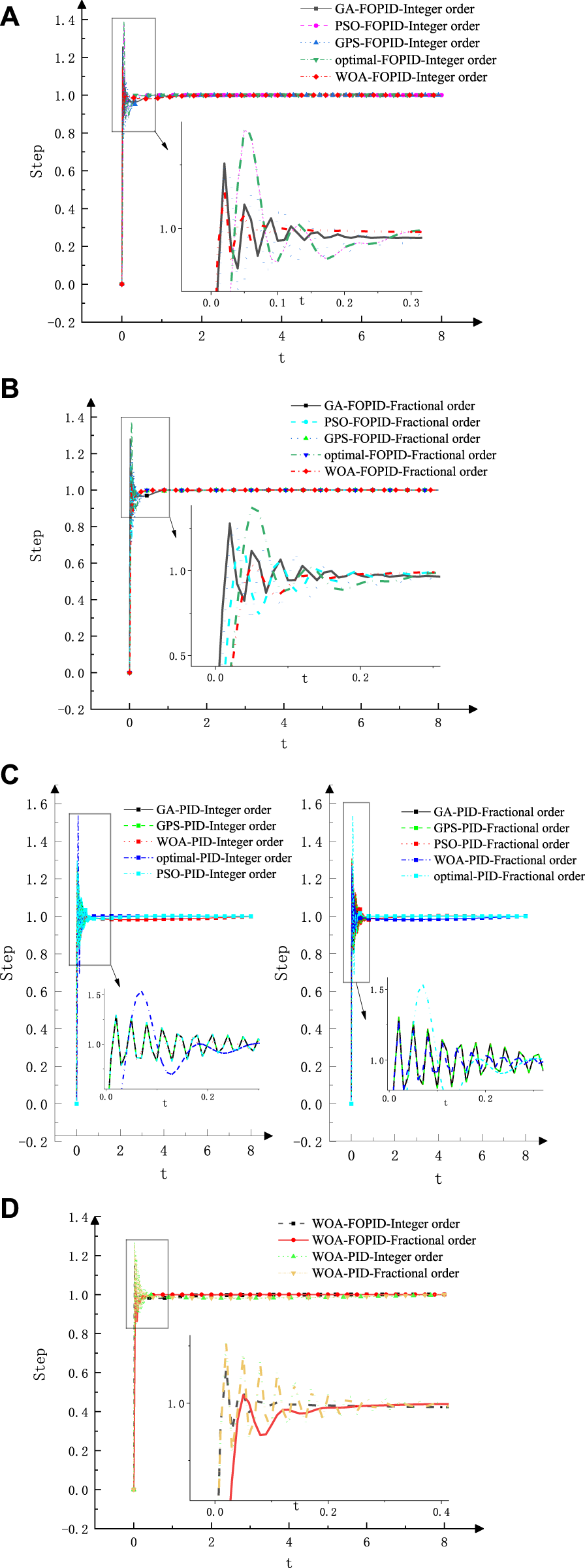
The manipulator is the key component of the anchor drilling robot to automatically complete the anchoring operation underground. Due to the complexity of its motion equation and the limitations of its control strategy, the real-time pose and positioning accuracy of the manipulator are inferior, which seriously restricts the safety, efficiency and speed of roadway excavation. In order to improve the positioning accuracy and realize optimal efficiency of the manipulator, this paper designs a manipulator structure with four degrees of freedom. With the help of D-H method and intelligent parameter setting method, this paper carries out the basic theoretical research on the kinematics and fractional order FOPID control algorithm of the manipulator of the mining roof bolter, and formulates a manipulator motion control strategy. At the same time, combined with numerical simulation and field experiment, we explore the robustness and control effect of the hydraulic system of the manipulator under the working conditions of harsh environment and limited space, and reveal that the intelligent optimization algorithm can control the motion state of the manipulator more accurately and stably after the parameters of the fractional order FOPID controller are positively determined. This study effectively solved the dynamic model uncertainty caused by time-varying internal parameters and external loads of the hydraulic servo system, optimized and reconstructed the structure and motion coefficient parameters of the manipulator, and revealed the control mechanism of precise spatial positioning and online trajectory planning of the hydraulic servo system of the manipulator. Compared with the traditional PID control algorithm, this algorithm has faster response speed and better expected track tracking ability. This research lays a theoretical foundation for precise positioning and automatic support of the manipulator, and also provides a reference for the design of similar motion control algorithms.

2,627 views

13 citations

ORIGINAL RESEARCH
12 August 2022
In situ stress measurement method of deep borehole based on multi-array ultrasonic scanning technology
Jinchao Wang, 4 more and Yiteng Wang

3,144 views

4 citations

ORIGINAL RESEARCH
25 July 2022
Numerical Method for the Deformation Calculation of the Shallow Buried Tunnel Caused by the Excavation of Overlying Soil Based on Soil Rebounding Characteristics
Jian Li, 5 more and Chaoxiong Li

2,357 views

2 citations

ORIGINAL RESEARCH
8 July 2022
An Effective Denoising Method Based on Cumulative Distribution Function Thresholding and its Application in the Microseismic Signal of a Metal Mine With High Sampling Rate (6 kHz)
Da Zhang, 5 more and Peng Han
An Effective Denoising Method Based on Cumulative Distribution Function Thresholding and its Application in the Microseismic Signal of a Metal Mine With High Sampling Rate (6 kHz)
Microseismic events can be used to analyze the risk of tunnel collapse, rock burst and other mine hazards in space and time. In practice, the artificial activities and other signals at the mining site can seriously interfere with the microseismic waveforms, reducing the signal-to-noise ratio. In this study, we propose a denoising method based on the threshold of the cumulative distribution function (CDF) of the wavelet coefficients in the wavelet domain using synchrosqueezed continuous wavelet transform (SS-CWT). First, the ratio of microseismic signal variance between two adjacent time windows is used to determine the range of background noise. Then, the microseismic signal is transformed to wavelet domain using SS-CWT, and the threshold of wavelet coefficients at each scale is estimated based on cumulative distribution function (CDF) of background noise. At last, a post-processing step is applied by utilizing an amplitude smoothing function, to further suppress the noise. The proposed denoising method is tested by both synthetic and filed microseismic data recored in metal mine. The results show that the method is effective in denoising and can improve the SNR of mine microseismic data with high sampling rate.

2,896 views

12 citations

The Calculation of Inelastic Zone Width of Coal Pillar in Highwall Mining With Backfill
ORIGINAL RESEARCH
5 July 2022
The Calculation of Inelastic Zone Width of Coal Pillar in Highwall Mining With Backfill
Juyu Jiang, 6 more and Zhengzhao Jia
Highwall mining with backfill technology will be one of the main techniques of raising the recovery rate of coal resources under the end wall all over the world in the future, in which the coal pillar setting is the key to ensure the successful application of this technology, and the calculation for inelastic zone width of coal pillar has important guiding significance for the coal pillar setting in highwall mining with backfill. However, at present,in order to accurately calculate the inelastic zone width of coal pillar under the condition of highwall mining with backfill, a calculation model of inelastic zone width of highwall mining with backfill independent of empirical parameters is established by using limit equilibrium method, orthogonal experiment method, and nonlinear fitting method. In order to verify the correctness and reliability of the model, this paper takes the geological conditions of the Antaibao Open-pit Mine in Pingshuo, Shanxi Province, China, as the engineering background to verify the calculation accuracy of the model. The results show that the calculation model established in this paper can accurately calculate the inelastic zone width of the coal pillar under highwall mining with backfill and can meet the engineering needs.

4,007 views

4 citations