 Yabing Xu
 Hui Tong1*
 Meng Chen
- 1School of Architecture and Urban Planning, Shandong Jianzhu University (Shandong University of Architecture and Engineering), Jinan, China
- 2School of Architecture and Built Environment, Deakin University, Geelong, VIC, Australia
Introduction: Historical-cultural landscapes and urbanscapes integrate regional culture, collective memory, urban patterns, living habits, and other related historical and spatial information, and are important places for expressing the values of urban space. This study analyzes cultural landscapes and urbanscapes from the perspective of spatial values, taking the Baihuazhou historic and cultural district in Jinan as an example to analyze the spatial identification of public cultural space. The significance of this research lies in examining the urban regeneration of public cultural space using multi-scale geospatial data from both an objective and subjective perspective. This methdology is based on a large body of previous literature in relation to cultural heritage, and draws on a comprehensive understanding of the field.
Methods: This study applies spatial syntax, visual graph, and survey analyses, focusing on urban spatial patterns, spatial culture, and spatial memory as heritage values.
Results: The analysis results reveal that historic districts generally do not have good accessibility, predominantly because of the disorganized texture of the buildings and absence of spatial consistency.
Discussion: There should be improved dynamic spatial identification and accessibility in older urban environments and enhancement of local spatial identification memory by increasing sightline accessibility. Based on consideration of values, corresponding suggestions are made from the three perspectives of urban space, cultural landscapes, and local collective memories to provide a reference for the protection of the Baihuazhou historic district and promote the preservation and development of similar heritage spaces.
1 Introduction
With the progressive improvement of the conservation theory of urban heritage and rational promotion of experimentation, the focus of urban heritage renewal and preservation has gradually shifted from preservation of historic townscapes, including such elements as urban “style” and “features,” to the conservation of urban heritage, including the incorporation of historical landscapes and corresponding elements into protected categories. Public spaces serve as the basic framework for urban landscape and reflect the history and cultural diversity of urban societies while allowing for a greater level of social diversity (Kubat et al., 2020). The public cultural space of the old city in Jinan, regarded as the heart of the urban historical landscape and its local collective memory, which is considered a reflection of intangible urban heritage, are essential to the heritage renewal of Jinan as a city characterized by its spring spaces. However, because of the contradiction between modern urban development and the renewal of urban heritage, cultural spaces with intangible values, such as the “spirit of place,” have been eroded or have even vanished to varying degrees. Consequently, the core of the city has disintegrated, and its characteristics have been diluted, which are in urgent need of restoration (Jia et al., 2022). The spirit of a place as the emotional connection people have made to the place, based on the distinctive qualities of its landscape, cultures, and built environment (Kubat et al., 2020).
Similar related academic research has been carried out on the cognitive mapping of urban spatial structures. Based on space syntax method and theory, many studies have been conducted in this research field with the aim of promoting sustainable living on a finite planet. “The influence of natural and man-made surroundings on how people feel, think, and interact is a major focus” of environmental psychology theory (Bonnes and Carrus, 2004). Montello (2007) proposed that “urban spatial environments are differentiated in that they often appeared chaotic and disorienting”. A more fundamental insight of environmental psychology has been recognized in that the make-up of an environment essentially, combines cognitive psychology with environmental psychology (Jen 2014). Dalmas et al. (2015) filled the research gap between spatial cognition and architecture and set the stage for the establishment of a framework for the future collaboration between disparate areas. Bendjedidi et al. (2019) assumed that the high dependent of “human behaviour in space on the visibility generated by the built environment”, aiming to investigate the “correlation between the users of space and spatial quantitative measures”. Kubat et al. (2020) reconsidered the effects of the spatial configuration of urban layout and land-use pattern on the performance of wayfinding to develop physical design solutions.
This study takes the Baihuazhou historic district of Jinan as an example. It encompasses a multitude of water spring cultural spaces and embodies the abundant spiritual essence of the place, thereby epitomizing the value of urban space heritage. This research focuses on the construction of urban space renewal from the perspective of spatial identification and provides corresponding proposals from an integrated perspective encompassing urban space, culture, and collective memory. This study provides a valuable reference for the conservation of the Baihuazhou historic district, which can help promote the preservation and development of analogous heritage spaces. Spring culture is not only a specific type of urban culture that has formed under the influence of spring spaces but also a characteristic regional culture with historical and cultural backgrounds. The spring cultural space specifically refers to the integration of the environment and district buildings influenced by the context of springs and their systems (Wu et al., 2022; Wang M. et al., 2023). The scope of the current study includes not only the spring cultural space, but also the correlation between the inhabitants and spring space, as well as the relationship between buildings and streets shaped by spring water.
2 Overview of study area
2.1 Cultural space characteristics of Baihuazhou historic district
Jinan is a typical city associated with springs, where the texture of springs and cultural spirit serve as fundamental elements that shape its urban space. Specifically, the formation of urban patterns is derived from the arrangement of spring spaces, with Daming Lake regarded as the urban center and four areas concentrated on the major springs as crucial commercial and service zones (He et al., 2021). Moreover, the evolution of urban texture is inseparable from the prevalence of spring culture and is guided by the literati spirit.
The flow of spring water follows the topography of Jinan, which slopes downward from south to north. Consequently, the urban development of Jinan was planned in accordance with the spring geography and its corresponding trends during its initial construction, which has generated abundant and interconnected spring spaces. Generally, spring cultural spaces can be categorized into five areas: 15 spaces in the Black Tiger Spring group outside Jinan’s venerable rampart, 21 spaces in the Baotu Spring group, and 16 spaces in the Five-Dragons Pool Park. Daming Lake in Jinan is an integrated spring cultural space with rich connotations without separate quantification. The Pearl Spring group has approximately 38 spaces dedicated to the springs (Dalmas et al., 2015; Eldiasty et al., 2021).
Despite the lack of a fixed long-term area of spring cultural space in the General’s Temple, there are still 24 spring-related spaces, totaling over 110 spring spaces with distinct characteristics. Baihuazhou historic district, centered around the Pearl Springs group, contains the greatest number and most diverse types of spring cultural spaces, making it a highly valuable research site (see Figure 1).

FIGURE 1. Spatial distribution of spring culture in Jinan.
An analysis of the spring cultural spaces in Jinan City indicates that the Baihuazhou historic district has the largest number and most diverse forms of spring cultural spaces (Cullen, 1961; Wang S. Y. et al., 2023). This study’s scope encompasses the historical areas enclosed by Furong Street and West Huaqiangzi Street to the west, Furong Lane to the south, Qushuiting Street and West Gengdao Street to the east, and Lulubazi Street to the north. The spatial location is adjacent to the Confucian Temple on the western side, and is bordered by the southern end of Qushuiting Street and Tengjiao Pond on the eastern flank (Eldiasty et al., 2021). To the south is a contemporary shopping mall. The integral configuration and historical attributes of the space progressively diminish from north to south (see Figure 2).
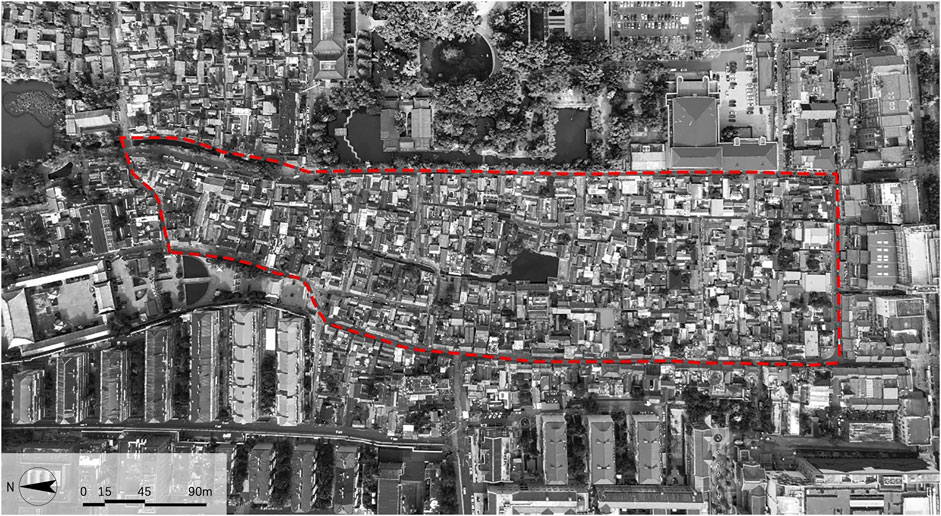
FIGURE 2. The boundary of the area of study.
According to information from the Jinan Planning Bureau in 2005, historic districts cover an area of 21.2 square kilometers, while the building area is only 10.72 square kilometers, and the building density is 0.51. The gross construction area is 27.39 square kilometers, resulting in a current plot ratio of 1.29 compared to the building area. Additionally, most of the existing 1926 houses are single-story structures, and the ambience of ancient architecture is imbued in historical districts.
The Pearl Springs group is predominantly distributed within the scope of this research and is characterized by highly concentrated springs. There are 40 spring cultural spaces, with five adjacent and interactional cultural spaces accounting for 36.1% of all such spaces in Jinan City. According to the Jinan Famous Springs bureau, there are nine prominent springs among the 72 famous springs in this district, as well as 30 named springs that are not included in the above-mentioned list and 20 unnamed springs. Additionally, small water areas, such as Wangfu Pond and Baihua Pond, which are formed by spring water accumulation, serve as significant spring cultural spaces and places for spiritual communion (see Table 1).

TABLE 1. Statistics of spring cultural spaces in this study.
Spring culture also encompasses the distinct attributes of place spirit and primary–secondary relationships (Luo et al., 2022). From the perspective of the city, the spring cultural space is primarily comprised of Qushuiting Street and Baihuazhou Pond, supplemented by small-scale spring cultural spaces with great influence, such as Wangfu Pond and the Pearl Spring (Liao et al., 2021). It represents the core of the urban spirit, showcasing the royalty integrating centralization in the historical spirit of place and the evolution of urban development, showing the characteristics of urban life in which the citizens live and prosper by the springs, while revealing the regional cultural features. It embodies the spirit of the city (Long and Zhou, 2016; Fang and Li, 2022; Hegazi et al., 2022; Wang Y. Y. et al., 2023).
From the perspective of the district area, the primary spring cultural spaces are those with high visibility, good preservation, and significant cultural influence, such as Wangfu Pond, Pearl Spring, and Tengjiao Spring. They are supplemented by enclosed and interconnected spring spaces, including Longfeng Spring, Wangfu Pond, and Lotus Spring (Cullen, 1961). At this point, the spirit of the spring cultural space is more aligned with that of the environment in historical streets, emphasizing the relationship between residents and each spring, as well as cultural exchanges and behavioral interactions between tourists and spring spaces (Shen and Dong, 2022; Luino et al., 2023). Presently, cultivating a sense of cultural identity within this location—focusing on the spirit of place culture—is strongly emphasized.
From the perspective of architecture and life, the spirit of place attribute emphasizes spiritual significance, embodied in memory, and is centered on the scenes of people living in this area as its primary embodiment. Consequently, there is no consistent primary or secondary spatial relationship in the spring cultural space under these circumstances (Geng et al., 2022; Jiang et al., 2022). It is difficult to estimate the master–auxiliary relationship based solely on the distance between residents living in the area and their corresponding spring cultural spaces (Gao et al., 2020). For instance, inhabitants living in the Wangfu Pond area have a deep feeling towards Wangfu Pond because of their prolonged proximity to the pond. Women wash their garments by the pond, people disport themselves within its water, children catch minuscule fish nearby, and senior citizens play mahjong and chat nearby. It endows people with incredibly rich collective memories as well as a deep resonance with the spring and feeling of life (Zhou et al., 2023). Therefore, the inhabitants attach more importance to Wangfu Pond than to the Baihuazhou historic district, which is farther away but has greater influence.
2.2 The influence of local collective memory on urban space
The Baihuazhou historic district possesses a wealth of place spirits and local collective memories, which are categorized into an urban spirit, which refers to a settlement pattern, in particular, to living by the spring; a literati spirit, which becomes intelligential owing to the springs; and a spirit of place in living memory from the perspective of the range of nonmaterial influences.
The spirit of a place shapes its urban pattern and texture, whereas the spring culture determines the urban humanistic relationship. From the perspective of a city, the spirit of the urban place directly influences the zoning plans of cultural relic protection. Furthermore, the ambience of the place spirit surrounding the spring determines the variations in the texture of district spaces. From the area’s perspective, the spirit of a place influences not only the population composition but also the building density, architectural style, and features. From the perspective of the crowd, the spirit of a place influences spatial patterns through spatial memory, which, in turn, determine future trends in cultural spaces through memory and inheritance (Kara and Iranmanesh, 2022).
The urban spirit of the spring cultural spaces partly shapes the texture of cultural districts. The spatial extent of spring culture gradually diminishes from north to south, and the characteristics of urban space and attributes of place spirit are correspondingly weakened, seeming to become more like modern high-rises (Aimar et al., 2021; Kırmızı and Karaman, 2021; Della Spina and Giorno, 2022; Zhang F. et al., 2022). Consequently, the connection between streets and spring culture has become increasingly weak, leading to a chaotic street texture. As street density increases, the characteristics imparted by the spring culture are lost.
Hence, the spring culture fundamentally influences street texture. If the spring culture is not properly implemented, it thoroughly diminishes the spatial and textural characteristics of cultural streets. The spirit of place influences not only the population composition but also the building density, architectural style, and features (Luino et al., 2023). Overall, the southern region exhibits a higher density of buildings, with 56% and 87% more areas having a density of more than 0.5 households/m2 compared to the northern and central regions, respectively. In other words, as spring cultural spaces diminish and become homogeneous, the density of buildings increases, resulting in a decline in residents’ living comfort. Architectural styles are becoming increasingly irregular, cluttered, and unplanned (Zhou et al., 2011; Jiang et al., 2022). The population composition is gradually transitioning from scattered individuals in the south to long-term residents living in lanes with memories of the city and the spring water. The density of people in the streets also changes with the presence of spring water spaces. The primary spring water serves as a cultural space, attracting a large number of people. Buildings at different heights, water systems and roads as shown in Figure 3.
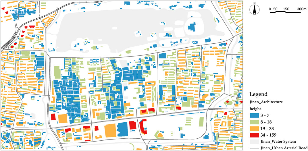
FIGURE 3. Distribution map of buildings at different heights, water systems and roads.
Cultural spirit encompasses the literati spirit and learning institutions, which significantly affects the cultural ambience and activities in public spaces. Historically, spring water, a symbol of literary talent and officialdom, partly determines the locations and forms of buildings like schools and other edifices, while also influencing the function and pattern of surrounding structures.
Urban spatial patterns and forms are determined by the spring’s spirit of place. Essentially, the spirit of place is the most vacant aspect of spatial patterns and content (Jiang et al., 2022). Spatial memory is the most extensive part, with the most ambiguous value within the place spirit, serving as a blueprint for the development of restoring and regenerating spatial heritage. Spatial memory forms the foundation of spatial prototypes. Only through memory can people vividly narrate historical records, allowing for their continued transmission through oral history.
Spatial memory comprehensively encapsulates the implications of spring cultural spaces, including crowd activities, memorable events, and spaces that require spatial memory to conduct. These memories subtly influence the spaces of spring culture, resulting in space retention or renewal of their patterns.
2.3 Analysis of spirit of place values in Baihuazhou historic district
Essentially, research on urban heritage renewal equals value assessment, which considers both material and nonmaterial factors, with greater emphasis on the latter. The preservation of physical buildings and spaces, including how, what, and how much to preserve, is closely related to the intangible spirit of a place. It represents the spiritual and ideological program underlying urban renewal, as previously mentioned.
First, research on the place spirit of the Baihuazhou historic district embodies authenticity through the isomorphic structural features between the historic city and residential courtyards (Fafouti et al., 2023). Additionally, the city and its architecture use synchronic and diachronic space-time logic to complement each other (Xu et al., 2020; Ding et al., 2023). The revitalization of urban heritage relies on the prototype of urban space (Jani and Hussain, 2011), which also holds true for street districts. The spatial construction pattern of the Baihuazhou historic district is derived from both the natural organization and artificial planning of spring spaces. In terms of urban place spirit, the spirit of cultural space in Baihuazhou originated by shaping its urban space prototype. In other words, it involves restoring and respecting the authentic characteristics of spaces that have historical significance.
Second, it embodies Jinan’s cultural values, with springs being a significant manifestation of its culture. Concerning the diverse spring spaces, Zhao Mengfu vividly depicts the grandeur of Baotu Spring’s cultural space in his verse “Clouds and mists shrouding the Huashan Mountain, sound of waves roaring and resonating through the Daming Lake … ” Meanwhile, Yanbi praises the Black Tiger Spring as “Deep in the hollow of the cliff, the water is grey, and it seems that there is a real black tiger hiding there” in his poem “Seventy-two Springs” (Yu et al., 2018; Amado and Rodrigues, 2019; Liu et al., 2023; Yang et al., 2023). Additionally, the spiritual attributes of spatial arrangements serve as crucial foundations for the spirit of place. Spring cultural spaces have always been regarded as a symbol of power, as evidenced by the Ming Dynasty seigniors who connected their mansions to springs to demonstrate their ruling power over the city. Additionally, as a symbol of the literati, the spring spaces changed the layout of the buildings, enhancing by design the spatial interaction between the institution of learning and the spring. Moreover, they serve as a symbol of the good wishes of the common people. Therefore, spring cultural spaces have profoundly impacted people from all walks of life since ancient times, giving rise to a rich and distinctive urban space and culture (Kırmızı and Karaman, 2021).
Third, the spirit reflects the significance of memory. Springs are crucial components of the urban life that surrounds spring spaces. They not only affect the lifestyle of those who live by the spring, but also create moments in their memory, which will form a memorial space full of life. There are busy women laundering clothes beside the spring, playful children, and older people chatting. For indigenous people, modern urban lifestyles cannot replace the convenience of using—and superior quality of—spring water (Aimar et al., 2021). Furthermore, the local inhabitants adapt to the humid climate generated by the springs, contributing to perpetuate the “living by the spring” lifestyle for a long period. The inhabitants of Furong Street continue this way of life (see Figure 4).
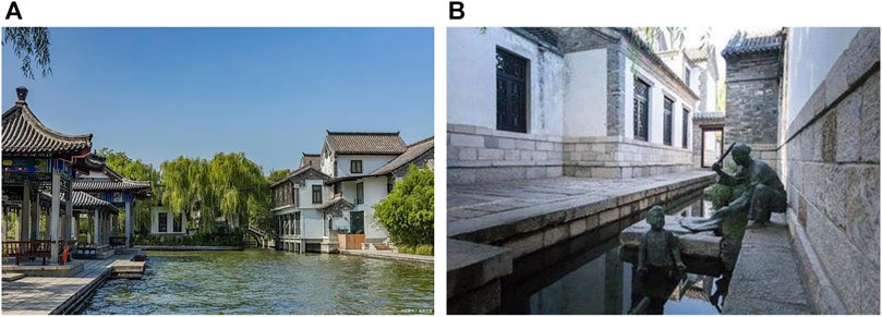
FIGURE 4. (A) Memorial space in Jinan Liberation Pavilion; (B) Sculpture of residents’ living scene.
Finally, it represents the potential value of the spirit of place. To examine the spirit of place, this study analyzes the space itself from the perspective of overall space rather than the architectural, regional, or material aspects of heritage, enabling individuals to discover value beyond the confines of human and urban perspectives.
3 Methodology
To investigate the effects of physical spatial elements made up of spatial identification of pedestrian flow activities and sightlines, and to reveal the effects of static spatial elements on the interaction of dynamic motion, a typical historical district called Baihuazhou was chosen based on the functional types and spatial privacy within the research scope. The analysis model, which included building and water system elements, was constructed in accordance with the principle of obstructing the sightline and providing resistance to pedestrian flow movement. It is based on space syntactic sightline analysis and a pedestrian flow simulation model.
The research method is based on space syntax analysis, which involves applying analysis results of experiential qualities on historical streets. Kaplan elucidated this approach by highlighting the following four key “informational elements”: coherence, complexity, legibility, and mystery (Cullen, 1961). He writes: “mystery embodies the attraction of the bend in the road, the view partially obscured by foliage, the temptation to follow the path” (Cullen, 1961). This research mainly focuses on the evaluation of experiential qualities, providing an objective description for the strategy design with respect to promoting experiential qualities (Xu et al., 2020).
The Baihuazhou historic and cultural district is used as an example in this research to analyze its spatial identification, as well as the spatial spirits of the citys and locals’ memory, with a focus on its urban spatial patterns, spatial culture, and locals’ spatial memory as heritage values. This research examines cultural characteristics from the perspectives of spatial identification and urban spatial patterns (Bandarin and Oers, 2014). A city’s overall impression, which is an external expression of its physical spatial features, is referred to as a city in the narrow sense of spatial identification analysis. A district’s overall identity comprises a variety of components, including architecture, landscape greening, and the built environment. The interaction between people and spatial structures, as well as the process of understanding the overall space from the local space while walking around, are examples of the internal logic of spatial identification. Using image identification, space syntax, and other analysis techniques, this research integrates the internal logic of the external expression of spatial identification and analyzes the coupled relationship between urban spatial identification and spatial structure based on multisource data (Bodnar, 2015). The method applies spatial syntax, visual graph, and survey analyses, focusing on urban spatial patterns, spatial culture, and spatial memory as heritage values.
Space syntax is a calculative method used to understand the spatial patterns and configuration to help capture user experience and reflect visual and compositional attributes within a given space (Xu et al., 2020; Xu et al., 2021a). Topological analysis methods of space syntax are based on axial lines with additional consideration of shortest physical paths. Topological and geometrical analysis of space applies visual graph analysis (VGA) or access graph analysis. Among the main spatial analysis factors, the control value (C1i) refers to the reciprocal sum of other spatial connection values connected to the “i” spatial node as the following equation (Eldiasty et al., 2021):
The control value can reflect the influence and control relationships between different spaces. The larger control value denotes a greater degree of control of the “
The lower mean depth indicates the space is more convenient so the lower mean depth value is desired. In addition, the mean depth value can reflect the accessibility of each spatial node. The global integration value (
The global integration can reflect the aggregation and dispersion ability of the overall space. Besides the global integration value, the local integration value,
4 Results
4.1 Analysis of spatial identification elements
Thirty-eight locations with historical memories and characteristics in the research region were subjected to full convolutional semantic segmentation image identification (Fafouti et al., 2023) based on the Baidu Street View Map. Based on concepts from research on the elements that influence spatial discrimination, the majority of the material spatial elements in the region are composed of buildings, sky, and landscape components that are dominated by plants (Figure 5).
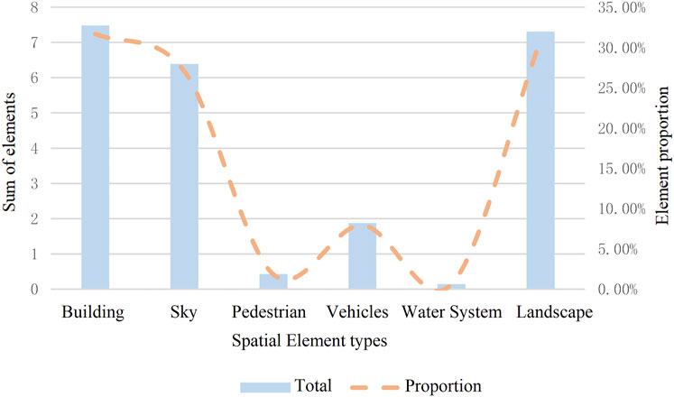
FIGURE 5. Summary of physical space elements’ identification data.
The primary explanation is that low buildings and high building density, combined with a good sky view and low tree canopy, are the primary contributors to the organic growth of historical districts. The land plant environment is primarily composed of bushes, the spatial scale of transportation highways is excessive, and certain residential alleys are devoid of vegetation (Figure 6).
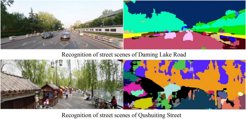
FIGURE 6. General view of partial spatial element identification.
4.2 Spatial structure analysis
4.2.1 Connectivity
Daming Lake Street, which connects the eastern and western areas of the space, has the highest connection value when viewed from the perspective of the entire area. It has a high degree of spatial permeability and relies on other urban areas. Other locations in the area are under its tight supervision, and their spatial perception is likewise better (Xu et al., 2020). Spaces with high connectivity are the main north–south traffic node spaces intersecting with Daming Lake Street, such as Anchasi Street, Xiandong Alley, and North Heihuquan Road. In terms of local street segments, the more organic urban texture and denser road network space in the eastern part of the section (Figure 7) are where the high connectivity street segments are primarily distributed. This area has more entrances and exits, more convenient transportation, and higher connectivity, all of which meet the requirements for walking-oriented travel in old urban areas.
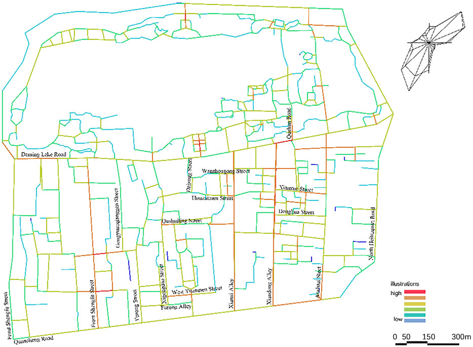
FIGURE 7. General view of connectivity analysis.
4.2.2 Global integration
The high-accessibility space begins primarily from the traffic area, which overlaps strongly with the high connectivity spaces, according to the analysis of the overall integration (Zhao and Tao, 2014; Jones, 2016; Taylor, 2018; Zhang J. et al., 2022). The spatial organization is “one axis and two belts,” which runs along Daming Lake Street’s east–west axis (Luo et al., 2022) and the south–north two belts of West Alley and East Alley of the County to the Baihuazhou Historic District, where the centrality is strongest. In addition, the region with the highest average accessibility is situated in the eastern road network, which is easier to access because of its greater density and functional complexity (Crumley et al., 2017). The interior garden paths and exterior urban environment in Daming Lake Park have quite different textures, acting as natural barriers. The entrance space connected to Daming Lake Street and the eastern region scenic land space with more concentrated sightseeing paths are spaces with the highest accessibility to ornamental walks, and these spaces have more recognizable landscapes (Figure 8).
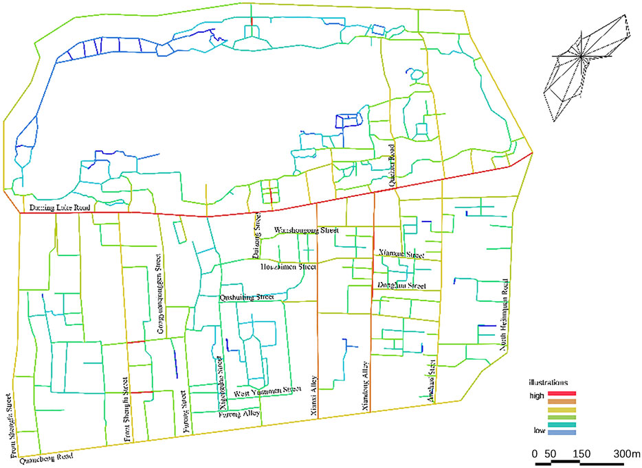
FIGURE 8. General view of global integration analysis.
4.2.3 Local integration
The eastern living space continues to be the core of the high-accessibility space with a noticeable difference in total integration, as can be seen from the standpoint of pedestrian integration. Additionally, the practicality and centrality of tourist routes inside picturesque areas have increased, along with the ability to recognize living scenes in a three-dimensional space. However, historical districts generally do not have good accessibility, mostly because of the disorganized texture of the buildings and the absence of spatial consistency (Figure 9).
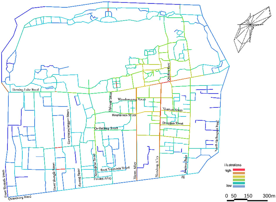
FIGURE 9. General view of local integration analysis.
4.2.4 Average depth
According to the analysis of comprehensive integration and average depth, there is a lack of coordination between integration and depth in many spaces. This is primarily manifested as high integration values corresponding to high depth values, indicating that these road sections have strong centrality but insufficient convenience; that is, they bear urban transportation functions beyond their own carrying capacity. The landscape area in Daming Lake Park has the largest depth value, which matches the requirements for viewing the landscape during garden construction (Ornelas et al., 2023). The pursuit of “one scene at a time, winding around” deepens the area to create an appealing effect. The high depth values of local spaces in historical districts have generated problems for spatial tourism overall, resulting in poor spatial continuity and accessibility (Figure 10).
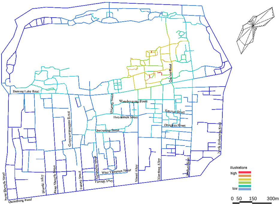
FIGURE 10. General view of average depth analysis.
4.2.5 Intelligence value
Local and global integration have a correlation coefficient of 0.428, which is average but still less than 0.5. Considering this, the road system under study has average spatial intelligence, making it theoretically challenging to effectively comprehend one’s location in relation to other locations in the region. Compared with the current scenario, the integration of new and ancient spaces under urban succession is clearly not ideal, and natural components are abundant, which affects people’s perceptions of their surroundings (Figure 11).
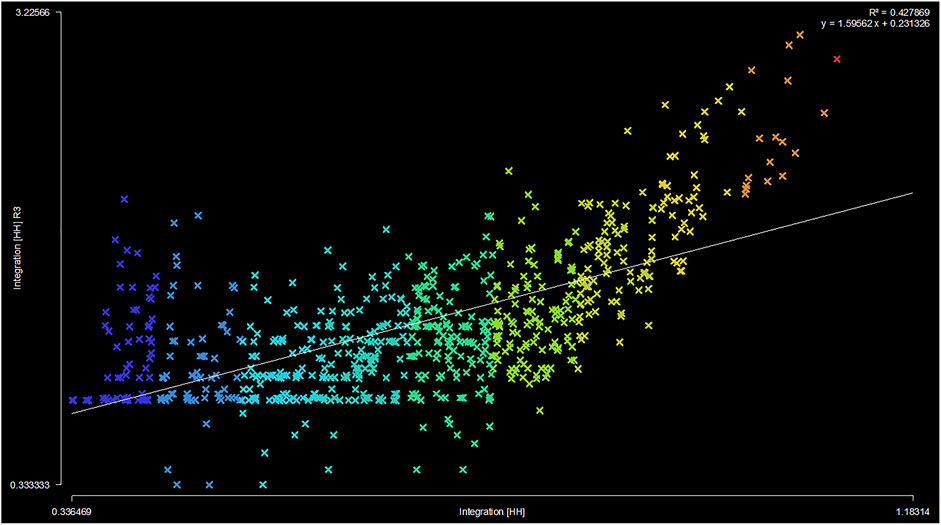
FIGURE 11. General view of intelligence value analysis.
4.3 Analysis of element correlations
The correlation analysis between the structural components of street space identification and the space syntactic parameters that represent the urban spatial structure reveals that various components of street space identification depend on various spatial structures in different ways (see Table 2).
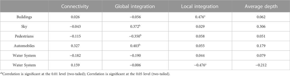
TABLE 2. Correlations between physical space elements and space syntax parameters.
As shown in Table 2, the global integration spatial structure affects the sky, people, and vehicles, whereas the small-scale integration spatial structure affects the elements of architecture and the landscape. The primary cause is that local nodal spaces are created by architecture and the landscape, while the movement of people and vehicles reflects interactions between local space and the overall spatial structure, thus influencing local space.
4.4 The impact of spatial identification on pedestrian flow and sightlines
To investigate the effects of physical spatial elements made up of spatial identification on pedestrian flow activities and line of sight and to reveal the effects of static spatial elements on the interaction of dynamic motion, a typical historical district called Baihuazhou was chosen based on the functional types and spatial privacy within the research scope. The analysis model, which included building and water system elements, was constructed in accordance with the principle of obstructing the line of sight and providing resistance to pedestrian flow movement. It is based on space syntactic line-of-sight analysis and a pedestrian flow simulation model (see Table 3).
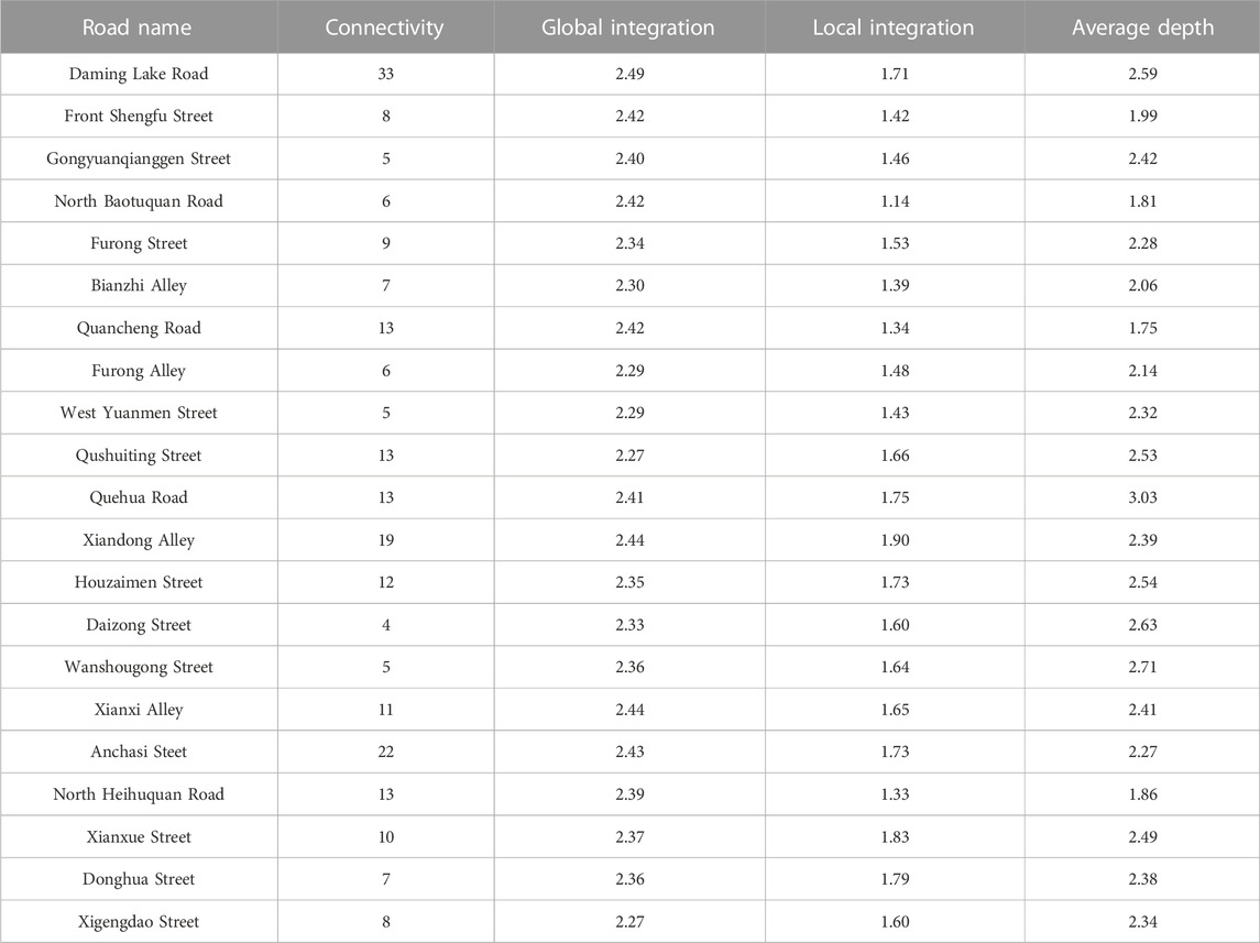
TABLE 3. Correlations between street and spatial syntactic parameters.
The central water system is surrounded by a highly accessible space for sightlines, which forms a visual center at the intersection of the east–west and north–south streets connecting the water system, according to the analysis of global sightline integration. There is no clear visual center in the southern and northern spaces because of the high density and disorganized texture of the structures. The linear space of the roadways, as presented in Figure 12, is primarily in the high-visibility region. According to a simulation of the global undifferentiated pedestrian flow activity, the primary pedestrian flow activity is in the main street space connected by the starting space, with a concentration in the center and southern spaces. The activity intensity is low because of the discontinuity in the northern space, and the entire area lacks a distinct core (Figure 12).
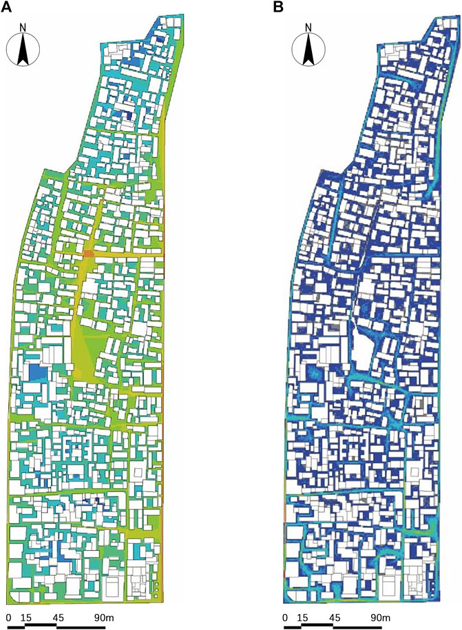
FIGURE 12. (A) General view of sightline integration analysis; (B) general view of pedestrian flow simulation analysis.
Self-organized architectural textures are disorganized and overly dense, creating barriers to sightlines and movement (González and Vázquez, 2014; Ogryzek et al., 2016; Varnaci Uzun and Somuncu, 2019; Hassan et al., 2022). The water system aids in gathering and guiding sightlines but also hinders the movement of individuals. Maintaining the stability of the overall system is challenging because of the interactions between various parts, which results in the development of nodes with strong spatial identification and discontinuous sequences distributed in the overall space.
5 Discussion
Based on the analysis results discussed in Section 4, the following spatial identification optimization strategies are recommended.
5.1 Old city renewal strategy (overall)
5.1.1 The unified identification of the collective memory revival guidance space
It is challenging for an overall space to develop a cohesive identity that is distinct from other urban spaces, because of the discontinuity of the space and negative resistance by some material elements. This research uses historical materials and constructs a flexible spatial identity anchored in memory, as the historical and cultural districts represented by Baihuazhou have significant cultural connotations. In addition, we can create a concrete sense of spatial identity and direct its continuity and unity through the replication of collective memory using symbols that organically combine cultural memory and spatial aspects (Rakocija and Dimanic, 2013; Guo and Ioannides, 2014; Zhang and Han, 2022).
5.1.2 Improving dynamic spatial identification and accessibility in older urban environments
It is challenging to incorporate pedestrian movement continually and effectively into an overall high-accessibility space because of its uneven distribution and lack of horizontal connections. Because there is insufficient room for mobility, it is difficult to preserve a space in the long-term, and it is impossible to express a dynamic spatial identity. Architectural texture can be partially relaxed according to the existing axis structure to create a network spatial structure that continuously directs people into the interior and creates a reachable, coherent network space. This is helpful for enhancing the dynamic spatial identification of old urban areas as well as the stability and unity of overall spatial identification.
5.2 Space optimization strategy (local)
5.2.1 Enhancing spatial qualities with a minor upgrade in embroidery style
Improvement in the spatial identification of local areas is predominantly observed in the node space, as opposed to the unity and continuity of the overall spatial identification. The value of the node space is investigated through embroidered micro-updates, starting with building updates and landscape shaping, to refine and enhance spatial characteristics, seek similarities and differences, and shape memory points under the unity of overall spatial identification (Rodwell, 2018; Tian et al., 2022; Xie et al., 2022). This was conducted under the guiding principle of avoiding large-scale demolition and construction.
5.2.2 Enhancing local spatial identification memory by improving sightline accessibility
Because each node space is segmented as a result of a discontinuity in the sightline, connecting characteristic spaces becomes challenging and spatial identification is weakened. It is vital to consider adding signpost advice to create a sightline corridor that enables the nodes to see each other, enhancing the identification memory of distinctive regional locations, while moderately altering the architectural texture.
5.2.3 Enhancing the synergy between regional and global places through increased spatial permeability
A loop cannot be formed between some of the node spaces and the overall space because they have only one entrance route. To increase connectivity, increase spatial permeability, decrease travel expenses, improve the understanding of the space between local and overall structures, increase the synergy between local and overall spaces, and encourage the organic integration of local and overall spatial identification, additional entrances and exits for some node spaces could be added to improve the overall space’s accessibility.
6 Conclusion
This study investigates the relationship between the effects of geographical identification, static physical spatial elements, and dynamic urban spatial structures under the guidance of updating and optimizing problems based on multisource data and various quantitative analytic methodologies. The physical spatial element composition and spatial structural characteristics as well as their connected relationships were examined using the Baihuazhou historical district as an example to discover their interior workings. Methodologies for global and local updating and optimization have been suggested to enhance spatial identification. Additionally, because of the time accuracy of street-view image data, the data cannot be kept in the same year dimension, but the time horizon is no longer than 3 years, which restricts the research and will be improved in future studies.
The spring cultural space is very important to the urban history and cultural district pattern of Baihuazhou from the perspective of authenticity. First, it needs to be examined from the viewpoint of the city, and general recommendations and planning should be made for the Baihuazhou historical district; the essence of Baihuazhou’s authenticity lies in its adherence to the prototype of street and alley spaces, and its integration with contemporary architectural settings. To explore the sustainable renewal and development of the city according to the internal development laws of the city, and conforming to the urban texture, future research should pay attention to the modern street environment, and introduce the theory of “organic renewal,” while considering the actual situation and integrating this into the transformation of the spring cultural space. The primary manifestation is based on a historical prototype of a spring cultural space blended with the surrounding architectural environment for texture restoration. This allows the main manifestation to grow naturally while preserving the neighborhood’s growth characteristics and essence. Simultaneously, the district will not become an urban cultural island.
Respect should be shown for the key features of significant meeting spots along the center of spring culture’s spatial distribution in the neighborhood as well as the shifting patterns of surrounding residential areas. The memory content of the spring culture space in Baihuazhou primarily consists of collective activities that people can participate in in Wangfu Pond, communication activities that people can participate in inside the streets and alleys, public memories of holidays, and significant ceremonial and academic commemorative activities, as well as the preservation and inheritance of public activities. This space serves as a prototype and foundation for the dissemination of spatial culture. Residents and visitors can find shared relaxation at a wide or narrow interface between memory realms. In addition to enhancing the experience of street and alley spaces, it also provides practical services and advertising displays. Simultaneously, it opens up new avenues for the development of memory space in streets and alleys and transforms these physical spaces into organic “living entities.”
The above recommendations aim to reactivate people’s memories and restore them to spring cultural spaces through spatial transformation from different perspectives such as time, modern urban culture, future urban space, crowd memory, and life. A theoretical direction for Baihuazhou’s building of space renewal is proposed, with the value of “spirit of place” as the core and the renewal and reconstruction of spring culture “spirit of place” as the objective. The “spirit of place” and cultural space values are commonly overlooked in urban development. The examination of spring culture renewal through the lens of space spirit employs the methods of material space repair and humanistic memory awakening to stimulate the endogenous power of cultural space self-renewal and development. The space-spirit-centered approach is applicable to the regeneration of space legacies in all cities with distinct geographical and cultural qualities. This research also explores the elements of urban, humanistic, and memory spirits and analyzes the value of spring space using a case study of the spatial renewal of the Baihuazhou historical and cultural district in Jinan, beginning with the safeguarding of the old district’s spring cultural space. To stimulate new vitality in the old city and strengthen residents’ sense of identification with the spring public space, we propose ideas from three key perspectives: city, population, and culture. This will guide the spatial renewal of the historically and culturally significant Baihuazhou historical district in Jinan city and other areas with analogous situations.
Data availability statement
The datasets presented in this article are not readily available because no. Requests to access the datasets should be directed to eHV5YWJpbmcyMEBzZGp6dS5lZHUuY24=.
Author contributions
YX: Conceptualization, Data curation, Funding acquisition, Investigation, Methodology, Resources, Software, Supervision, Writing–original draft. HT: Conceptualization, Formal Analysis, Methodology, Visualization, Writing–review and editing. MC: Methodology, Project administration, Resources, Visualization, Investigation, Writing–review and editing. JR: Conceptualization, Data curation, Formal Analysis, Methodology, Writing–review and editing. RZ: Investigation, Resources, Software, Writing–original draft.
Funding
The authors declare financial support was received for the research, authorship, and/or publication of this article. This research was funded by the Natural Science Foundation of China (No. 72204149), the YX Doctoral Scholars Grant Program of Shandong Jianzhu University (X21109Z) and Natural Science Foundation of Shandong Province (ZR2021QE207).
Conflict of interest
The authors declare that the research was conducted in the absence of any commercial or financial relationships that could be construed as a potential conflict of interest.
Publisher’s note
All claims expressed in this article are solely those of the authors and do not necessarily represent those of their affiliated organizations, or those of the publisher, the editors and the reviewers. Any product that may be evaluated in this article, or claim that may be made by its manufacturer, is not guaranteed or endorsed by the publisher.
References
Aimar, F., Gullino, P., and Devecchi, M. (2021). Towards reconstructing rural landscapes: a case study of Italian Mongardino. J. Rural. Stud. 88, 446–461. doi:10.1016/j.jrurstud.2021.06.021
Amado, M., and Rodrigues, E. A. (2019). A Heritage-based method to urban regeneration in developing countries: the case study of Luanda. Sustainability 11, 4105. doi:10.3390/su11154105
Bandarin, F., and Oers, R. (2014). Reconnecting the city: the historic urban landscape approach and the future of urban heritage. Chichester, England: Wiley-Blackwell, 1–16.
Bendjedidi, S., Bada, Y., and Meziani, R. (2019). Urban plaza design process using space syntax analysis: el-Houria plaza, Biskra, Algeria. Int. Rev. Spatial Plan. Sustain. Dev. A Plan. Strategies Des. Concepts 17 (2), 125–142. doi:10.14246/irspsda.7.2_125
Bonnes, M., and Carrus, G. (2004). Environmental psychology, overview. Encycl. Appl. Psychol. 16, 801–814. doi:10.1016/b0-12-657410-3/00252-x
Crumley, C., Kolen, J., de Kleijn, M., and van Manen, N. (2017). Studying long-term changes in cultural landscapes: outlines of a research framework and protocol. Landsc. Res. 42, 880–890. doi:10.1080/01426397.2017.1386292
Dalmas, L., Geronimi, V., Noël, J.-F., and Tsang King Sang, J. T. K. (2015). Economic evaluation of urban heritage: an inclusive approach under a sustainability perspective. J. Cult. Herit. 16, 681–687. doi:10.1016/j.culher.2015.01.009
Della Spina, L., and Giorno, C. (2022). Waste landscape: urban regeneration process for shared scenarios. Sustainability 14, 2880. doi:10.3390/su14052880
Ding, W. Q., Wei, Q. Q., Jin, J., Nie, J. J., Zhang, F. F., Zhou, X. T., et al. (2023). Research on public Space Micro-renewal strategy of historical and cultural blocks in Sanhe ancient town under perception quantification. Sustainability 15, 2790. doi:10.3390/su15032790
Eldiasty, A., Sabry Hegazi, Y. S., and El-Khouly, T. (2021). Using space syntax and TOPSIS to evaluate the conservation of urban heritage sites for possible UNESCO listing the case study of the historic centre of Rosetta, Egypt. Ain Shams Eng. J. 12, 4233–4245. doi:10.1016/j.asej.2021.04.017
Fafouti, A. E., Vythoulka, A., Delegou, E. T., Farmakidis, N., Ioannou, M., Perellis, K., et al. (2023). Designing cultural routes as a Tool of responsible tourism and sustainable local development in isolated and less developed islands: the case of Symi island in Greece. Land 12, 1590. doi:10.3390/land12081590
Fang, Q. L., and Li, Z. (2022). Cultural ecology cognition and heritage value of Huizhou traditional villages. Heliyon 8, e12627. doi:10.1016/j.heliyon.2022.e12627
Gao, Q., Yin, D., and Zhu, H. (2020). Urban regeneration and emotional politics of place in Liede Village, Guangzhou, China. Habitat Int. 103, 102199. doi:10.1016/j.habitatint.2020.102199
Geng, S. R., Chau, H., Jamei, E., and Vrcelj, Z. (2022). Understanding the street layout of Melbourne’s Chinatown as an urban heritage precinct in a grid system using space syntax methods and field observation. Sustainability 14, 12701. doi:10.3390/su141912701
González, P. A., and Vázquez, A. M. (2014). Between planning and heritage: cultural parks and National heritage areas. Eur. Spat. Res. Policy 21, 33–46. doi:10.1515/esrp-2015-0003
Guo, J., and Ioannides, M. (2014). “Heritage landscape conservation and development in Lecture notes in computer science,” in 5th EuroMed international conference, 8740. Editors N. Magnenat-Thalmann, E. Fink, R. Zarnic, and A. Y. Yen (Amathus, Cyprus: E. Quak), 687–696.
Hassan, G. F., Rashed, R., and Nagar, S. M. (2022). Regenerative urban heritage model: scoping review of paradigms’ progression. Ain Shams Eng. J. 13, 101652. doi:10.1016/j.asej.2021.101652
He, Q. S., Larkham, P., and Wu, J. Y. (2021). Evaluating historic preservation zoning using a landscape approach. Land Use Policy 109, 105737. doi:10.1016/j.landusepol.2021.105737
Hegazi, Y. S., Tahoon, D., Abdel-Fattah, N. A., and El-Alfi, M. F. (2022). Socio-spatial vulnerability assessment of heritage buildings through using space syntax. Heliyon 8, e09133. doi:10.1016/j.heliyon.2022.e09133
Jani, M. H., and Hussain, M. R. (2011). Cultural landscape. A new paradigm for landscape architecture. In first ifla asia and the pacific region symposium on landscape architecture education. First ifla asia and the pacific region symposium on landscape architecture education (solare 2011). Perbadanan Putrajaya Complex, Putrajaya, 30 March – 2 April.
Jia, S. Z., Liao, Y., Xiao, Y. Q., Zhang, B., Meng, X. B., and Qin, K. (2022). Conservation and management of Chinese classical royal garden heritages based on 3D digitalization – a case study of Jianxin courtyard in Jingyi garden in fragrant hills. J. Cult. Herit. 58, 102–111. doi:10.1016/j.culher.2022.09.020
Jiang, J., Zhou, T. C., Han, Y. R., and Ikebe, K. (2022). Urban heritage conservation and modern urban development from the perspective of the historic urban landscape approach: a case study of Suzhou. Land 11, 1251. doi:10.3390/land11081251
Jones, D. (2016). Evolution and significance of the regeneration reserve heritage landscape of Broken Hill: history, values and significance. Hist. Environ. 28, 40–57. doi:10.3316/informit.111181383723276
Kara, C., and Iranmanesh, A. (2022). Modelling and assessing sustainable urban regeneration for historic urban quarters via analytical hierarchy process. Land 12, 72. doi:10.3390/land12010072
Kırmızı, Ö., and Karaman, A. (2021). A participatory planning model in the context of historic urban landscape: the case of kyrenia’s historic port area. Land Use Policy 102, 105130. doi:10.1016/j.landusepol.2020.105130
Kubat, A. S., Ozer, O., and Ekinoglu, H. (2020). “The effect of built space on wayfinding in urban environments: a study of the historical peninsula in Istanbul,” in Eighth international space syntax symposium, Santiago De Chile.
Liao, P., Gu, N., Yu, R. R., and Brisbin, C. (2021). Exploring the spatial pattern of historic Chinese towns and cities: a syntactical approach. Front. Archit. Res. 10, 598–613. doi:10.1016/j.foar.2021.04.002
Liu, Y., Shen, L. Y., Ren, Y. T., and Zhou, T. (2023). Regeneration towards suitability: a decision-making framework for determining urban regeneration mode and strategies. Habitat Int. 138, 102870. doi:10.1016/j.habitatint.2023.102870
Long, Y., and Zhou, Y. (2016). Quantitative evaluation on street vibrancy and its impact factor: a case study of Chengdu. New Archit. 1, 52–57. doi:10.1177/2399808317715640
Luino, F., Gizzi, F. T., Palmieri, W., Porfido, S., and Turconi, L. (2023). Historical memory as an effective and useful Tool for proper land use planning: lessons learnt from some Italian cases. Land 12, 1751. doi:10.3390/land12091751
Luo, J., Jian, I. Y., Chan, E. H. W., and Chen, W. (2022). Cultural regeneration and neighborhood image from the aesthetic perspective: case of heritage conservation areas in Shanghai. Habitat Int. 129, 102689. doi:10.1016/j.habitatint.2022.102689
Montello, D. R. (2007). “The contribution of space syntax to a comprehensive theory of environmental psychology”, in Proceedings of the 6th international space syntax symposium. paper presented to.
Ogryzek, M., Rzasa, K., and Kulawiak, M. (2016). Cultural heritage in spatial planning (baltic geodetic congress) (BGC GEOMATICS) (gdańsk, polska, june).
Ornelas, C., Sousa, F., Guedes, J. M., and Breda-Vázquez, I. (2023). Monitoring and assessment heritage tool: quantify and classify urban heritage buildings. Cities 137, 104274. doi:10.1016/j.cities.2023.104274
Rakocija, J., and Dimanic, M. (2013). “Affirmation and integration of architectural heritage in urban landscape: contribution of landscape architecture,” in Eleventh international forum of studies—the paths of the merchants: aversa, Italy, 13–15 june. Editors F. C. C. Fabbrica della Conoscenza, and M. Piscitelli, 1142–1149.
Rodwell, D. (2018). The historic urban landscape and the geography of urban heritage. Hist. Environ. Policy Pract. 9, 180–206. doi:10.1080/17567505.2018.1517140
Shen, D., and Dong, S. (2022). Transition of urban morphology in the mountainous areas since early-modern times from the perspective of urban historic landscape—a GIS tools and historical map translation approach. Sustainability 14, 12896. doi:10.3390/su141912896
Taylor, K. (2018). Connecting concepts of cultural landscape and historic urban landscape: the politics of similarity. Built Herit. 2, 53–67. doi:10.1186/BF03545710
Tian, M., Li, Z., Xia, Q., Peng, Y., Cao, T., Du, T., et al. (2022). Walking in China’s historical and cultural streets: the factors affecting pedestrian walking behavior and walking experience. Land 11, 1491. doi:10.3390/land11091491
Varnaci Uzun, F., and Somuncu, M. (2019). Cultural landscape: concepts, methodologies, tools, and applications. Geospatial Intell. Concepts Methodol. Tool. Appl., 203–229. doi:10.4018/978-1-5225-8054-6.ch010
Wang, M., Luo, Z. W., Jiang, R. H., and Zhao, M. S. (2023). Heritage space, multiple temporalities, and the reproduction of Guangzhou Overseas Chinese Village. Emot. Space Soc. 48, 100958. doi:10.1016/j.emospa.2023.100958
Wang, S. Y., Zhang, J. Y., Wang, F., and Dong, Y. (2023). How to achieve a balance between functional improvement and heritage conservation? A case study on the renewal of old Beijing city. Sustain. Cities Soc. 98, 104790. doi:10.1016/j.scs.2023.104790
Wang, Y. Y., Crompton, A., and Agkathidis, A. (2023). The Hutong neighbourhood grammar: a procedural modelling approach to unravel the rationale of historical Beijing urban structure. Front. Archit. Res. 12, 458–476. doi:10.1016/j.foar.2022.12.004
Wu, J. Y., Lu, Y. T., Gao, H., and Wang, M. (2022). Cultivating historical heritage area vitality using urban morphology approach based on big data and machine learning. Comput. Environ. Urban Syst. 91, 101716. doi:10.1016/j.compenvurbsys.2021.101716
Xie, Y. H., Yang, R. X., Liang, Y. Q., Li, W., and Chen, F. L. (2022). The spatial relationship and evolution of world cultural heritage sites and neighbouring towns. Remote Sens. 14, 4724. doi:10.3390/rs14194724
Xu, Y., Rollo, J., and Esteban, Y. (2021a). Evaluating experiential qualities of historical streets in nanxun canal town through a space syntax approach. Buildings 11, 544. doi:10.3390/buildings11110544
Xu, Y., Rollo, J., Esteban, Y., Tong, H., and Yin, X. (2021b). Developing a comprehensive assessment model of social value with respect to heritage value for sustainable heritage management. Sustainability 13, 13373. doi:10.3390/su132313373
Xu, Y., Rollo, J., Jones, D. S., Esteban, Y., Tong, H., and Mu, Q. (2020). Towards sustainable heritage tourism: a space syntax-based analysis method to improve tourists’ spatial cognition in Chinese historic districts. Buildings 10, 29. doi:10.3390/buildings10020029
Yang, L., Li, J., Chang, H.-T., Zhao, Z., Ma, H., and Zhou, L. (2023). A generative urban space design method based on shape grammar and urban induction patterns. Land 12, 1167. doi:10.3390/land12061167
Yu, H., Hou, S., and Lang, L. (2018). The exploration of historical blocks’ protection and renovation based on the theory of city image. Curr. Urban Stud. 6, 425–432. doi:10.4236/cus.2018.63023
Zhang, F., Liu, Q., and Zhou, X. (2022). Vitality evaluation of public spaces in historical and cultural blocks based on multi-source data, a case study of Suzhou Changmen. Sustainability 14, 14040. doi:10.3390/su142114040
Zhang, J., Sun, H., Xu, S., and Aoki, N. (2022). Analysis of the spatial and temporal distribution and reuse of urban industrial heritage: the case of Tianjin, China. Land 11, 2273. doi:10.3390/land11122273
Zhang, Y., and Han, Y. K. (2022). Vitality evaluation of historical and cultural districts based on the values dimension: districts in Beijing City, China. Herit. Sci. 10, 137–215. doi:10.1186/s40494-022-00776-5
Zhao, Z. Q., and Tao, L. (2014). Study on intangible cultural heritage protection of the architectural,” in 3rd International Conference on Civil, Architectural and Hydraulic Engineering (ICCAHE), Hangzhou, China, 30–31 July.
Zhou, K., Wu, W., Dai, X., and Li, T. (2023). Quantitative estimation of the internal spatio–temporal characteristics of ancient Temple heritage space with space syntax models: a case study of Daming Temple. Buildings 13, 1345. doi:10.3390/buildings13051345
Keywords: historical and cultural district, public cultural space, urban regeneration, cultural landscapes, case study
Citation: Xu Y, Tong H, Chen M, Rollo J and Zhang R (2023) Examining the urban regeneration of public cultural space using multi-scale geospatial data: a case study of the historic district in Jinan, China. Front. Built Environ. 9:1328157. doi: 10.3389/fbuil.2023.1328157
Received: 26 October 2023; Accepted: 15 November 2023;
Published: 30 November 2023.
Edited by:
Jiazhen Zhang, University of Mons, BelgiumReviewed by:
Hongpeng Fu, Northeastern University, United StatesYi He, Huazhong University of Science and Technology, China
Copyright © 2023 Xu, Tong, Chen, Rollo and Zhang. This is an open-access article distributed under the terms of the Creative Commons Attribution License (CC BY). The use, distribution or reproduction in other forums is permitted, provided the original author(s) and the copyright owner(s) are credited and that the original publication in this journal is cited, in accordance with accepted academic practice. No use, distribution or reproduction is permitted which does not comply with these terms.
*Correspondence: Hui Tong, Um92ZXJAc2RqenUuZWR1