 Alba Lucia Meneses-Baez1
 Elvia Isabel Casas-Matiz2*
- 1Faculty of Psychology, Universidad Católica de Colombia, Bogotá, Colombia
- 2Faculty of Design, Universidad Católica de Colombia, Bogotá, Colombia
Introduction: The visibility of rurality contributes to optimizing the planning and administrative management processes of the territories by providing contextualized information about the relationship of the inhabitants with the area under study. The objective of this research is to identify the mechanisms of visibility of rurality in Usme, a locality in Bogotá, Colombia.
Methods: A case study was carried out using a mixed methodology. Based on a literature review, conceptual categories that support the visibility of rurality were formulated, and based on them, a perception survey addressed to the peasant leaders of Usme was designed. The survey contained 22 questions that inquired about socio-demographic data, citizen participation, roles of the inhabitants, participation scenarios, conditions, institutions, opportunities for improvement, and the needs and processes of the locality; the questions were multiple-choice with a single answer and open-ended. The survey was sent to 50 peasant leaders, of whom 36 responded (13 men, 21 women, and 2 LGBTIQ), who were residents of low (25), medium (3), and high (8) localities in the rural zone of Usme. Using the ATLAS.ti program, a frequency analysis was carried out for the multiple-choice questions and the textual data, as well as a content analysis of deductive and emergent categories; then, a nomological network on the mechanisms of visibility was constructed.
Results: Findings show that participants understand rurality visibility mechanisms in terms of five dimensions: spaces of visibility, dimensions of rurality, forms of participation, places of participation, and types of impact.
Discussion: The delimitation and definition of the dimensions that constitute the mechanisms of rurality visibility in the borders contribute to the designing of effective strategies to improve the conditions of the inhabitants of this area, as well as their participation in increasing the impact and coverage of the institutions of the territory, aiming to improve the quality of life of the inhabitants of the area. We concluded that, in order for this to happen, it is necessary to have community empowerment and social co-responsibility among the community, civil institutions, and government.
Introduction
In recent decades, community participation has led to the development of the concept of citizen agency, which refers to active, responsible, autonomous, self-governing citizens who are aware of their freedoms and rights, possess the necessary knowledge to exercise their power, advocate for their own rights and those of others, give voice to their concerns, and work hand-in-hand with other actors and institutions to improve the living conditions of their communities (Bifulco, 2012; Babu, 2016).
The development of citizen agency among farmers requires the commitment of the educational, political, economic, and social sectors, working on inclusive local, regional, and national agendas in order to promote co-responsibility, commitment, and forms and rules for the participation of farmers. Citizen agency should be part of political leaders’ agendas in order to understand the problematic situations of farmers, coordinate cooperative alliances with the private sector, and formulate and implement solutions. Accordingly, government and civil society institutions should have various channels to promote the recognition of the importance of the knowledge and interests of farmers in terms of their needs and proposed solutions, as well as effective formal and non-formal mechanisms for collecting and communicating information. In addition, the education sector could contribute to the development of agency in rural children and youth through curricula. The economic sector could offer incentives to those farmers who formulate proposals to make visible the tangible and intangible heritage of these communities, along with alternative solutions to their most pressing needs (Bifulco, 2012; Babu, 2016; Gaudin, 2019).
This requires both community empowerment and the social co-responsibility of the community and governmental and non-governmental organizations. These sectors need to work together and drive the development of programs and projects in response to recognized needs and opportunities such as socio-spatial attributes, resources, identity, means of production, shortages, socio-environmental needs, hopes, social networks, and governmental and private organizations available, among others (Ziccardi, 1998; Melo Macías et al., 2016; Gaudin, 2019).
Community engagement and participation contribute significantly to the sustainable development of ecosystems in general but become crucial for farmers in impoverished territories. In developing countries such as Colombia, achieving the sustainability of these territories, which involves the quality of life of their inhabitants, is a challenge for governments and society. Therefore, the promotion and strengthening of community participation are key to the sustainability of these territories, including the quality of life of their inhabitants (Ziccardi, 2004; Barrera, 2009; Cano Malaver, 2017).
Moreover, the construction of effective mechanisms of community participation at distinct levels of management reduces the spatial and cultural gaps of border and rural territories, improving environmental and social sustainability (Ahern, 2011; Barrios-Salcedo and Casas-Matiz, 2019; Chester and Allenby, 2019). This process fosters the efficiency of finite resources and the co-responsibility of the care, conservation, preservation, and strengthening of eco-systemic values among the interactions between collectives and their living space (Fahmy et al., 2019; Han, 2021; Losasso, 2021).
In this context, rural visibility mechanisms refer to the ways in which citizens of rural territories share with civil society and local and national government their values, knowledge, skills, artifacts, and needs and give their voice to validate the existence of their narratives and guide the construction of actions and projects with the help of others who contribute to the purpose of achieving better living conditions for their rural community (Mayntz, 2010).
Therefore, this process demands the analysis of social and institutional relationships and their impact on the agency processes of communities. These self-management processes strengthen and recognize the capacities of popular sectors to modify their habitat and respond to their needs based on their own participation and decisions (Ramírez Miranda, 2014; González, 2015; Benavidez Burgos, 2016; López Santos et al., 2017; Ginés Sánchez and Querol Vicente, 2019).
Rural and border territories maintain historical relationship dynamics that are under-recognized in territorial planning and design. Usually, the capacity of rural inhabitants to act as agents of change is diminished by processes of informality, with a low or inadequate institutional presence accompanied by private promoters. This situation contributes to restricting the conditions of physical and virtual connectivity of these communities and the recognition and prioritization of the needs and requirements of other groups, especially urban ones; furthermore, government development proposals favor general plans that do not address the particularities of these territories (Hart, 2005; Healey, 2003).
In addition, illiteracy, digital illiteracy, and gender inequality present in these communities are conditions that increase the violation of their rights to participate in an informed manner in decision-making processes, along with the possibility of building their own territorial models that respond to their needs and offer sustainability opportunities for the countryside (Casas-Matiz and Ruiz Parrado, 2020).
Thus, it is necessary to consider mediation mechanisms that offer peasant communities opportunities for participation, including processes of literacy and digital infrastructure that make their involvement inclusive, without falling into a mirror gaze that disfigures their own content (Elías and Scotson, 2015).
Visibilization and participation mechanisms are instruments that facilitate the involvement of communities in government actions through meetings that encourage debate within a framework of institutional openness. Their implementation strengthens the agency of communities with respect to both decision-making regarding public policy (Gehl, 2014) and the management of the inhabitant’s recognition and their territory with its characteristics (Gaudin, 2019; Acosta and Ribotta, 2022).
States must guarantee that peasants and other people living in rural and border territories actively participate in the identification of their needs and priorities, as well as in the planning and execution of programs and projects that ensure a dignified life for their communities and guarantee socio-environmental and economic sustainability for their territories.
Objective
The objective of this research is to identify the visibility mechanisms of rurality in Usme, a locality in Bogota, Colombia1.
Study type
A case study was carried out using a mixed methodology (Creswell and Creswell, 2018). This research integrated the collection and analysis of quantitative and qualitative data to describe the visibility mechanisms of rurality in Usme.
Materials and methods
Participants
The participants consisted of 36 volunteer farmers, of whom 58% were women and 8% were victims of the armed conflict. Although the sample was not randomly selected, all participants met the inclusion criteria of being over 18 years of age and currently living in the rural territory of Usme (Table 1).
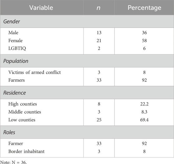
Table 1. Participants’ socio-demographic characteristics.
Instruments
A perception survey on rural visibility and participation mechanisms was designed for this study. It consisted of 22 questions: 12 multiple-choice with a single answer and 10 open-ended. This survey inquired about socio-demographic data, the meaning of visibility and participation mechanisms, suggestions for improving community participation, types of participation, roles of respondents, participation scenarios, forms of participation, context of respondents, aspects that strengthen the relationship between the community and government institutions, and the needs and expectations of the community regarding the improvement of conditions for rural dwellers.
Procedure
The research was carried out in three phases.
Phase one
Based on the bibliographic review, conceptual categories were formulated to support the visibility of rurality; this classification was considered to create the perception survey. Furthermore, a reflection on rurality and its innovation approaches was undertaken, addressing the traditional approach to territory habitability and the new forms and dynamics of urban–rural articulation, with the intention of ending this dichotomy. These approaches regarding rurality open up a complex bidirectional space for deliberation on territorial management decisions and productive, human, environmental, and spatial relationships between rural and urban localities; this framework informs comprehensive plans for rural sustainability (MAPA, 2003; Trpin, 2005; Ávila Sánchez, 2015; Berdegué and Soloaga, 2018).
Therefore, consideration should be given to traditional methods of organization, expanded production, and innovative processes that provide forms of balanced exchange, contributing to the wellbeing and quality of life conceived by the communities (Barkin and Rosas, 2006; Toledo, 2006). In this context, it is necessary to consider the revaluation of agriculture and external power relations mediated by the agro-industrial context since land, as a productive factor, is in a low position in the dominant power structure and at a disadvantage in decision-making (Machado Cartagena, 2009).
Phase two
Authorization to conduct the study was requested from the open government office of the local mayor’s office in Usme. Once obtained, the researchers contacted 50 rural leaders registered in this office by e-mail, explaining the purpose of this study, requesting their participation in filling out the survey, and asking for their support to send it to other members of the communities in each rural territory. Thirty-six farmers responded to the survey after signing informed consent and personal data authorization forms.
Phase three
The researchers conducted a frequency and percentage data analysis of the sociodemographic data. Then, they used ATLAS.ti (Scientific Software Development GmbH, 2020), a program that allows to codify conceptual categories through text, to perform a textual content analysis of the responses to each of the open-ended questions. Using ATLAS.ti, each researcher thoroughly reviewed each segment of the discourse independently to identify deductive and emerging categories that responded to each question posed. The triangulation technique was used to consolidate the categories, and later, the researchers conducted an analysis of the conceptual relationships between the categories, arranging them in diagrams. Lastly, the names of each category were reviewed in light of the collected data in order to validate each category and its components, generating the results.
According to the aims of the study, four categories were obtained after the data analysis.
Category 1
It focuses on observing the mechanisms of visibilization of the peasants of the locality of Usme in institutional and social aspects. In this category, the mechanisms of visibility and participation are instruments that facilitate the involvement of communities in government actions through meetings that promote debate. The implementation of these mechanisms supports public policy decision-making and requires adjustments to the contexts and communities that use them; in order to strengthen community empowerment, the territory serves as the most appropriate unit of measurement (Gaudin, 2019; Acosta and Ribotta, 2022).
Category 2
It focuses on the analysis of the rural territories (veredas) of the locality of Usme at three levels, namely, highlands, middlelands, and lowlands, to identify their mechanisms of participation in the institutional, social, and private spheres. The differential analysis contributes to the understanding of the processes of occupation and interaction, which become more diffuse as rural populations move away from urban influence, an effect that is the opposite in the low-rural territories because they are more visible and have a greater interaction with urban life and greater proximity to public and private organizations.
Category 3
It seeks to understand the tools that allow farmers in the highlands, middlelands, and lowlands to have a voice in the decision-making processes related to their interests and needs. To accomplish this, the following subcategories were established: differentiated spaces of visibility (public, private, or mixed); differentiated dimensions of rurality (social actors in rural–rural, rural–border, or neo-rural environments); forms of participation (face-to-face and virtual environments); proposed places of participation (farms, villages, rural zones, border zones, and urban zones), and type of impact of participatory processes (negative or positive impact). These subcategories seek to show the differential forms of visibility and participation of rural communities in the territory of Usme. They pursue a territorial planning that considers general processes common to the regional and local territory as well as global and national narratives of competitiveness and sustainability, which, in turn, strengthen local narratives and support the formulation of strategic, comprehensive, and diverse interventions based on the dynamics of social territorialization.
Category 4
It focuses on building recommendations for improvement in accordance with what was identified in the previous points. Figure 1 presents the methodological route and the categorical relationship system implemented.
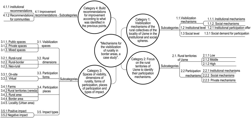
Figure 1. System of categories and subcategories of the project.
Results
The results show that the participants conceptualized the visibility and participation mechanisms of rurality through spaces of visibility, dimensions of rurality, forms of participation, places of participation, and purposes of participation (Figures 2, 3).
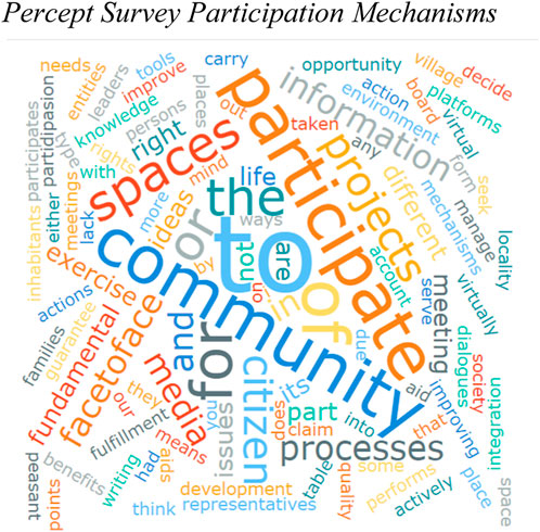
Figure 2. Perception survey participation mechanisms.
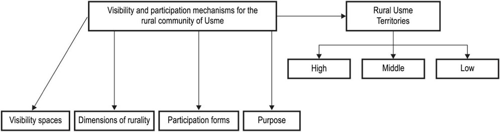
Figure 3. Visibility and participation mechanisms within Usme’s rural community.
Definition of visibility and participation mechanisms
For the participants of this study, participation mechanisms are defined as the means through which citizens can make informed decisions, allowing them to exercise their fundamental rights regarding processes and projects aimed at improving the quality of life of rural dwellers living in a particular territory.
Visibility spaces in Usme’s rural community
For the participants in this study, the spaces for visibility and participation of the rural population of Usme consist of public, private, and mixed spaces (Figure 4). The former are those provided by Usme’s governmental organizations (local) or external organizations such as the Bogotá Mayor’s Office or ministries. The private spaces are those made possible by individual management, the community in general, political parties, or civil society organizations. Finally, mixed spaces are those that require the co-management of governmental or civil society actors.
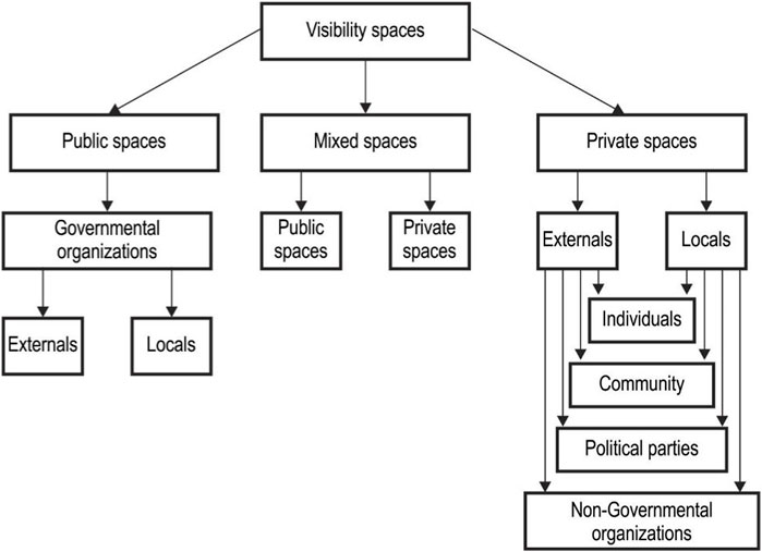
Figure 4. Visibility spaces within Usme’s rural community.
Forms of participation within Usme’s rural community
For the participants of this study, the forms of participation in the rural community of Usme are face-to-face and virtual. Face-to-face participation occurs in the rural context of Usme, followed by those occurring in the local district of Usme, while the preferred form of participation reported is a combination of face-to-face and virtual participation (Figure 5).
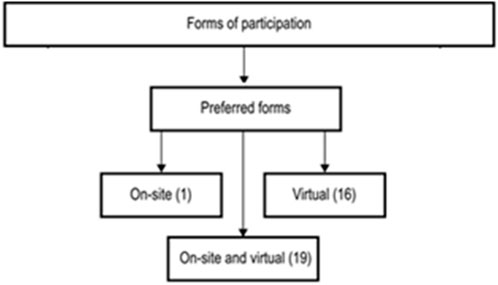
Figure 5. Forms of participation within Usme’s rural community.
The participants pointed out that these forms of participation are limited by difficulties in physical mobility and a lack of virtual connectivity in rural areas and highlands, especially since they decreased their participation and follow-up on improvement proposals.
Participation purposes within Usme’s rural community
Usme’s rural community participation purposes are evident in the meeting spaces that different society representatives (government institutions, civil society organizations, and community members) make possible in order to identify the resources of each rural territory (culture, ecosystem with its corresponding fauna, and agriculture), as well as in the search for support to establish the characteristics of the rural inhabitants of a territory and the identification of their needs in order to seek solutions that contribute to improving the quality of life of rural inhabitants (young farmers and their families).
Figure 6 shows how participants highlight their paths and what they consider should be highlighted in participation processes for the development of the territory. They pointed out the ecosystem services, the values of peasant culture, and the interdependence relationship with the city as providers of water, air, and food. They observe the resistance processes to urban expansion and highlight the need to take care of the social, cultural, and environmental values present in the territory.

Figure 6. Usme’s rural community participation purposes.
In the case of the participants, their most pressing needs are insecurity in the rural territories, exacerbated by poor public lighting; mobility problems due to scarce transportation services; and the adverse conditions of the tertiary roads that make difficult the transfer and commercialization of agricultural products that their community produces.
Recommendations for improving community participation in rural areas
The participants point out that government institutions, civil organizations, and citizens should open spaces for community meetings to work on issues of interest to the inhabitants that respond to their needs, such as access (transportation), security, and communication. Furthermore, it is essential to showcase the resources available, such as their agriculture and ecosystem characteristics that are specific to a rural territory. In addition, there is a need to determine the type of intervention by the state and other civil society institutions to improve the quality of life in the rural community.
It is also important that farmers’ rights become a reality, with change occurring through programs that support and generate community participation in the execution of projects that aimed at providing development opportunities for the countryside.
They also emphasized that peasants and their families should have the right to live a dignified life with peace and wellbeing, but for this to happen, change is needed through programs that support and generate community participation in the implementation of projects that provide development opportunities for the countryside. They consider that it should improve processes, provide access to timely information, expand calls for rural areas, and include vulnerable people who live on rent, have disabilities, or are elderly. Furthermore, institutions should create their real investment plans with communities, and these plans should be oriented to meet the true rural needs in high, medium, and low areas without the necessity of moving to the urban area according to the degree of importance since each place has distinctive characteristics. Finally, they mentioned the need to encourage interest in young people and adults, manage transportation and connectivity for highland villages, and guarantee spaces and technological tools in the dialog (Figure 7).

Figure 7. Importance of the situation of their path and rural areas.
Regarding the question of what factors should be proposed for improvement in the relationship between communities and public institutions in the locality, the participants highlight the need for institutional articulation and compliance with agreements, as well as differential investment, where projects are born cooperatively and recognize peasant experience. They emphasize the need to strengthen institutional credibility and citizen commitment, especially in young people, through dialog and active participation, respect for community times, and differential recognition of qualified or unqualified peasant human talent. Finally, they seek to strengthen a rural collective network that disseminates useful and truthful information.
Discussion
The objective of this research was to identify the mechanisms of visibility of rurality in Usme, a locality of Bogotá, Colombia, from the perspective of 36 inhabitants of the rural territory.
The results show that the participants in this study recognize the importance of participation mechanisms for rural communities and validate them as democratic spaces that allow them to learn about the problems of their territory and their communities, although the proposals are not effective all the time and do not always translate into real projects that change and improve their living conditions. They propose that the instruments used for collecting information consider differential values; for example, when referring to rural communities located in territories less close to the city, it is essential to identify the needs of vulnerable populations and strengthen the participation of rural youth. They emphasize that the social and cultural interactions of rural areas, especially in the highlands, are such that the processes of exchange with the city fade and the levels of visibility of the communities are lower. These facts are increased by the insufficient infrastructure of physical and virtual connectivity.
This is consistent with policies related to rural development that promote a non-dichotomous relationship between cities and their rural territories and recognize that the participation and empowerment of communities are the central axis for decentralizing public decision-making (Gaudin, 2019; Valencia-Perafán et al., 2020). This empowerment leads the communities to identify and act actively in the face of their problems and consider them as opportunities that they can work to translate into projects for the integral improvement of their habitat (Pisani and Franceschetti, 2009).
Therefore, understanding and improving the processes of visibilization and effective participation of rural communities require improving the comprehensive management of the territory, the responses to the challenges to design concerted strategies, and the construction of sustainable urban–rural connectivity, both physical and digital, within the framework of an open government policy that recognizes the sense of rootedness of rural inhabitants, their productive experiences, and their search for diversification and commercialization of their products. All these innovative and competitive strategies give rise to spaces that promote emerging, productive activities and an articulation between the countryside and the city, with a transformation of infrastructure that contributes to new forms of mobility and communication (González, 2015), which strengthen the interactions and territorialization processes present there (Ballesteros, 2013).
Rural territories, as shown in this study, are complex, with a diversity of variables and rural actors, private organizations, and local, regional, and national government institutions, which imply a broad and diverse perspective of the needs and opportunities of the countryside and border areas. This approach can lead to the formulation of strategic planning in response to the needs of these populations, considering the characteristics of the territory. The use of a broad perspective makes it possible to generate initial solutions to specific needs that evolve and can lead to the construction of a structure of innovative participation and visibility strategies that support the formulation of dynamic interventions involving an increasing number of variables and stakeholders. However, a general approach such as the one proposed, although not perfect, contributes to providing a range of solutions to most of the problems addressed.
The research of this study did not consider the age or educational level of the participants; we recognize this omission as a limitation to the study since these variables most probably influence the perspective of the participants.
Conclusion
We can conclude that although the recognition of rural areas today is proposed by public policy as an open alternative to the socio-environmental capital present there and that its validation is supported by the proposals of institutional and community co-responsibility with the purpose of joint and integral sustainable development, these initiatives require diagnoses, proposals, and concerted and joint actions that are concretized in institutional actions within the territory. In the same way, the mechanisms of participation and visibility that are currently used to know the dynamics of the rural territory of Usme are not enough for a rural population that maintains its community ties and its peasant identity as its distinctive value and that recognizes its peasant struggle to reduce the urban overflow on agricultural areas; hence, the largest number of proposals for improvement in the participation that the current participants propose are based on improving listening and co-creation of spaces, the strengthening of connectivity networks, and contemplating future developments in a multidimensional and integral way, where peasant social capital is one of the pillars of territorial impulse.
Data availability statement
The raw data supporting the conclusion of this article will be made available by the authors, without undue reservation.
Ethics statement
The studies involving humans were approved by Comité Ética Universidad Católica de Colombia. The studies were conducted in accordance with the local legislation and institutional requirements. The participants provided their written informed consent to participate in this study. Written informed consent was obtained from the individual(s) for the publication of any potentially identifiable images or data included in this article.
Author contributions
AM-B: Conceptualization, Formal Analysis, Methodology, Validation, Visualization, Writing–review and editing. EC-M: Conceptualization, Formal Analysis, Investigation, Methodology, Resources, Supervision, Validation, Writing–original draft.
Funding
The author(s) declare financial support was received for the research, authorship, and/or publication of this article. The authors declare that this research and its publication was supported by the Universidad Católica de Colombia Grant named: Proceso de recualificación de las interacciones del Corredor Socio-Ambiental Los Nevados-Líbano Tolima desde la Ecología Humana - Fase 1 granted to the authors in the year 2023.
Conflict of interest
The authors declare that the research was conducted in the absence of any commercial or financial relationships that could be construed as a potential conflict of interest.
Publisher’s note
All claims expressed in this article are solely those of the authors and do not necessarily represent those of their affiliated organizations, or those of the publisher, the editors, and the reviewers. Any product that may be evaluated in this article, or claim that may be made by its manufacturer, is not guaranteed or endorsed by the publisher.
Footnotes
1Usme is one of the 20 districts into which the capital of Colombia, Bogota, is divided. It is located in the southeast of the city and was formerly a municipality in the department of Cundinamarca, which was incorporated into the metropolitan area in 1954. Usme is separated from the main urban area of Bogota and includes several urban neighborhoods and rural areas. It is made up of seven zonal planning units (UPZs), which are divided into neighborhoods, and one rural planning unit (UPR). Usme has more than 120 neighborhoods and 17 rural territories (veredas) (https://www.usme.gov.co).
References
Acosta, L. D., and Ribotta, B. (2022). Visibilidad estadística y mecanismos participativos de los pueblos indígenas en América Latina: avances y desafíos. Comisión Económica para América Latina y el Caribe (CEPAL). Available at: https://repository.eclac.org/handle/11362/47750.
Ahern, J. F. (2011). From fail-safe to safe-to-fail: sustainability and resilience in the new urban world. Landsc. Urban Plan. 100 (4), 341–343. doi:10.1016/j.landurbplan.2011.02.021
Ávila Sánchez, H. (2015). La ciudad en el campo: expresiones regionales en México. México. Universidad Nacional Autónoma de México, Centro Regional de Investigaciones Multidisciplinarias.
Babu, A. (2016). “Redrawing boundaries: neoliberal governmentality and the politics of active citizenship,” in Democracy and civil society in a global era. New York, NY, USA(Routledge), 188–203.
Ballesteros, R. I. B. (2013). Centro de Estudios para el Desarrollo Rural Sustentable y la Soberanía Alimentaria (CEDRSSA). Estudios e investigaciones: nueva ruralidad; enfoques y propuestas para América Latina. Cuad. Geogr. Rev. Colomb. Geogr. 23 (1), 189–193. doi:10.15446/rcdg.v23n1.41093
Barkin, D., and Rosas, M. (2006). ¿Es posible un modelo alterno de acumulación? Una propuesta para la nueva ruralidad. Polis Rev. Latinoam. 5 (13), 361–371. Available at: https://journals.openedition.org/polis/5442.
Barrera, A. (2009). Innovación política y participación ciudadana. Tendencias democráticas en los gobiernos locales. H. Poggiese y T. T. Cohen Elger (Comps.), Otro desarrollo urbano: ciudad incluyente, justicia social y gestión democrática. 105–116.
Barrios-Salcedo, R. A., and Casas-Matiz, E. I. (2019). “La unidad compleja de análisis territorial UCAT: una herramienta de mediación en conflictos espaciales,” in Ponencia presentada en 1er. Encuentro de la Red Internacional de Investigación ERII, en el marco de la X Jornada de Investigación Institucional (Bogotá- Colombia: Universidad Católica de Colombia).
Benavidez Burgos, Y. T. (2016). La autoconstrucción y la producción social del hábitat. (PSH). Diferencias y Semejanzas. La construcción de bordes urbano-rurales en las ciudades latinoamericanas. Rev. Papeles Coyunt. 42, 232–253. Available at: http://repository.unipiloto.edu.co/bitstream/handle/20.500.12277/8246/Autoconstruccion_produccion-PapelesCoyuntura42.pdf?sequence=1&isAllowed=y.
Berdegué, J. A., and Soloaga, I. (2018). Small and medium cities and development of Mexican rural areas. World Dev. 107, 277–288. doi:10.1016/j.worlddev.2018.02.007
Bifulco, L. (2012). Citizen participation, agency and voice. Eur. J. Soc. Theory 16 (2), 174–187. doi:10.1177/1368431012459695
Cano Malaver, D. P. (2017). El paisaje periurbano: transformaciones, complejidad, percepciones e imaginarios en la localidad de Usme. [Trabajo de grado Maestría, Facultad de Ciencias Económicas, Universidad Nacional de Colombia] Available at: https://repositorio.unal.edu.co/handle/unal/62045.
Casas-Matiz, E. I., and Ruiz-Parrado, D. K. (2020). Modelo para el desarrollo resiliente y sostenible de áreas periurbanas y metropolitanas. Imaginarios sociales y representaciones. Bogotá, Colombia. XI Jornada de Investigación Universidad Católica De Colombia, 2016–2023. Available at: https://repository.ucatolica.edu.co/server/api/core/bitstreams/ca5433b6-d0a7-4b47-8172-c732445eac25/content.
Chester, M. V., and Allenby, B. (2019). Toward adaptive infrastructure: flexibility and agility in a non-stationarity age. Sustain. Resilient Infrastructure 4, 173–191. doi:10.1080/23789689.2017.1416846
Creswell, J. W., and Creswell, J. D. (2018). Research design. Qualitative, quantitative, and mixed methods approaches. 5th ed. Los Angeles, CA, USASAGE.
Elías, N., and Scotson, J. L. (2015). Establecidos y marginados. Una investigación sociológica sobre problemas comunitarios. 1a ed. Español: Fondo de Cultura Económica.
Fahmy, A. S., Abdou, A., and Ghoneem, M. Y. (2015). Regenerative architecture as a paradigm for enhancing the urban environment. Port-Said Eng. Res. J. 23 (2), 11–19. doi:10.21608/PSERJ.2019.49554
Gaudin, Y. (2019). Nuevas narrativas para una transformación rural en Latinoamérica y el Caribe. La nueva ruralidad: conceptos y medición. Santiago, Chile. Naciones Unidas. CEPAL, FIDA. Available at: https://repositorio.cepal.org/bitstream/handle/11362/44665/4/S1900508_es.pdf.
Ginés Sánchez, X., and Querol Vicente, V. A. (2019). Construcción social de lo rural y nueva ruralidad. Una aproximación al marco de interpretación de lo rural de agentes políticos y sociales. Econ. Agrar. Recur. Nat. 19 (1), 37–57. doi:10.7201/earn.2019.01.03
González, F. (2015). La ‘nueva ruralidad’en Cañuelas: entre la agroecología y las nuevas urbanizaciones. Mundo Agrar. 16 (31), 1–23. Available at: http://www.scielo.org.ar/pdf/magr/v16n31/v16n31a06.pdf.
Han, S. (2021). The use of transects for resilient design: core theories and contemporary projects. Landsc. Ecol. 36, 1567–1582. doi:10.1007/s10980-020-01172-9
Hart, R. (2005). Espacios para la construcción ciudadana. En Comprensiones sobre ciudadanía. Veintitrés expertos conversan sobre cómo construir ciudadanía y aprender a entenderse. Bogotá, Colombia. Transversales Magisterio, 57–68.
Healey, P. (2003). Collaborative planning in perspective. Planning Theory. 2 (2), 101–123. doi:10.1177/14730952030022002
López Santos, J., Castañeda Martínez, T., and González Díaz, J. G. (2017). Nueva ruralidad y dinámicas de proximidad en el desarrollo territorial de los sistemas agroalimentarios localizados. POLIS Rev. Latinoam. 16 (47), 211–233. doi:10.4067/S0718-65682017000200211
Losasso, M. (2021). Circular transition: scenarios for the future of design. TECHNE-Journal Technol. Archit. Environ. 22, 7–9. doi:10.36253/techne-11532
Machado Cartagena, A. (2009). La reforma rural: una deuda social y política. Bogotá, Colombia. Universidad Nacional de Colombia. Facultad de Ciencias Económicas. Centro de Investigaciones para el Desarrollo. CID.
MAPA (Ministerio de Agricultura, Pesca y Alimentación) (2003). El libro blanco de la agricultura y el desarrollo rural. Pesca y Alimentación, España: Ministerio de Agricultura.
Martínez, A., and Adolfo, F. (2019). Del patrón al modelo [re] composición del borde. Caso de estudio, borde periurbano de Bogotá, territorio de Usme. [Tesis de doctorado, Universidad Autónoma Metropolitana de Azcapotzalco] Available at: http://zaloamati.azc.uam.mx/handle/11191/7068?show=full.
Mayntz, R. (2010). “Global structures: markets, organizations, ¿networks - and communities?,” in Transnational communities. Shaping global economic governance. Editors M. L. Djelic, and S. Quack (Cambridge University Press), 37–54.
Melo Macías, A. L., Ramírez Mahecha, J. S., Forero González, J. A., Uribe Laverde, D. A., and Chávez Chaves, D. B. (2016). Acuerdos de la Habana, reforma rural integral y su enfoque étnico. Instituto para el Desarrollo Rural de Sudamérica. Movimiento Regional por la Tierra. Documento Técnico. Available at: https://porlatierra.org/docs/36513494f9992dff6066e0873c7be06f.pdf.
Pisani, E., and Franceschetti, G. (2009). Evolución del pensamiento económico agrario: de los agronegocios a la nueva ruralidad. Rev. FCA UNCuyo XLI (2), 85–108. Available at: https://mpra.ub.uni-muenchen.de/42810/1/MPRA_paper_42810.pdf.
Ramírez-Miranda, C. (2014). Critical reflections on the New Rurality and the rural territorial development approaches in Latin America. Agron. Colomb. 32 (1), 122–129. doi:10.15446/agron.colomb.v32n1.41218
Scientific Software Development GmbH (2020). ATLAS.ti [Software of qualitative data analyses]. Available at: https://atlasti.com/.
Trpin, V. (2005). El desarrollo rural ante la nueva ruralidad. Algunos aportes desde los métodos cualitativos. AIBR Rev. Antropol. Iberoam. (42), 1–16. Available at: https://www.redalyc.org/pdf/623/62304207.pdf.
Valencia-Perafán, M., Le Coq, J. F., Favareto, A., Mario Samper, M., Sáenz-Segura, F., and Sabourin, E. (2020). Políticas públicas para el desarrollo territorial rural en América Latina: balance y perspectivas. Eutopía. Rev. Desarro. Económico Territ. (17), 25–40. doi:10.17141/eutopia.17.2020.4388
Ziccardi, A. (1998). Gobernabilidad y participación ciudadana en la ciudad capital. México D. F. México. Universidad Nacional Autónoma de México, Instituto de Investigaciones Sociales Miguel Ángel Porrúa. Available at: https://ru.iis.sociales.unam.mx/handle/IIS/5650.
Ziccardi, A. (2004). Participación ciudadana y políticas sociales del ámbito local. México D. F. México. UNAM-Instituto de Investigaciones Sociales/Instituto Nacional de Desarrollo Social/Consejo Mexicano de Ciencias Sociales. Available at: http://ru.iis.sociales.unam.mx/handle/IIS/4420.
Keywords: rurality visibility, visibility mechanisms, participation, border areas, Usme
Citation: Meneses-Baez AL and Casas-Matiz EI (2024) Mechanisms of visibility of rurality and border areas in Usme. Front. Built Environ. 10:1264653. doi: 10.3389/fbuil.2024.1264653
Received: 21 July 2023; Accepted: 29 February 2024;
Published: 20 March 2024.
Edited by:
Grace Tibério Cardoso, Independent Researcher, Passo Fundo, BrazilReviewed by:
Max Stephenson Jr., Virginia Tech, United StatesSimona Mancini, University of Salerno, Italy
Copyright © 2024 Meneses-Baez and Casas-Matiz. This is an open-access article distributed under the terms of the Creative Commons Attribution License (CC BY). The use, distribution or reproduction in other forums is permitted, provided the original author(s) and the copyright owner(s) are credited and that the original publication in this journal is cited, in accordance with accepted academic practice. No use, distribution or reproduction is permitted which does not comply with these terms.
*Correspondence: Elvia Isabel Casas-Matiz, ZWljYXNhc0B1Y2F0b2xpY2EuZWR1LmNv