 Adam Zsarnóczay1*
 Gregory G. Deierlein1
 Frank McKenna2
 Matthew Schoettler2
 Sang-Ri Yi2
 Barbaros Cetiner2
 Aakash Bangalore Satish2
 Jinyan Zhao2Justin Bonus2
 Abiy F. Melaku2
 Sina Naeimi2
 Pedro Arduino3
 Rachel Davidson4,5
 Catherine Gorle1
 Sanjay Govindjee2
 Ahsan Kareem6
 Tracy L. Kijewski-Correa6,7
 Laura N. Lowes3
 Michael Motley3
 Seymour M. J. Spence8
 Ertugrul Taciroglu9
 Alexandros A. Taflanidis6
 Matthew DeJong2
- 1Department of Civil and Environmental Engineering, Stanford University, Stanford, CA, United States
- 2Department of Civil and Environmental Engineering, University of California, Berkeley, Berkeley, CA, United States
- 3Department of Civil and Environmental Engineering, University of Washington, Seattle, WA, United States
- 4Department of Civil and Environmental Engineering, University of Delaware, Newark, DE, United States
- 5Disaster Research Center, University of Delaware, Newark, DE, United States
- 6Department of Civil and Environmental Engineering and Earth Sciences, University of Notre Dame, Notre Dame, IN, United States
- 7Pulte Institute for Global Development, University of Notre Dame, Notre Dame, IN, United States
- 8Department of Civil and Environmental Engineering, University of Michigan, Ann Arbor, MI, United States
- 9Department of Civil and Environmental Engineering, University of California, Los Angeles, Los Angeles, CA, United States
Computational simulation is a critical tool for assessing the impacts of natural hazards and informing risk mitigation and resilience strategies. The NHERI SimCenter has developed an open-source, modular framework that integrates performance-based engineering methodologies with regional-scale assessments to enable multi-hazard, multi-scale simulations. This paper presents the conceptual foundation and current capabilities of the SimCenter platform, covering hazard characterization, structural response analysis, damage and loss estimation, and recovery modeling. By leveraging high-performance computing, standardized data schemas, and open-source tools, the platform facilitates transparent, reproducible research while bridging local and regional analyses. Key contributions include improved inventory generation, damage simulation, and recovery analysis, with applications extending across multiple hazard domains. The paper also discusses challenges in implementing high-resolution, high-fidelity simulations, advancing multi-hazard assessments, and enhancing accessibility for a broad user base. Looking ahead, expanding hazard models, refining regional-to-local modeling techniques, and fostering community collaboration will be essential for advancing computational simulation in natural hazards engineering. Through continued development, the SimCenter aims to provide researchers and practitioners with scalable, adaptable tools to enhance disaster risk assessment and resilience planning.
1 Introduction
Natural hazards, including earthquakes, hurricanes, and tsunamis, pose significant risks to communities, infrastructure, and economies worldwide. Understanding and mitigating these risks require advanced computational simulation tools capable of capturing the complexities of hazard events, structural vulnerabilities, and community resilience. Over the past decade, advancements in computational modeling have enabled researchers to develop more sophisticated simulations that inform risk mitigation strategies and disaster recovery efforts. However, to maximize the impact of these tools, there is a critical need for collaboration and shared resources across disciplines.
Recognizing this need, the Natural Hazards Engineering Research Infrastructure (NHERI) was established as a national initiative in the United States to provide a comprehensive research ecosystem supporting the study of natural hazards and their impact on the built environment. As part of this initiative, the NHERI SimCenter has developed a cohesive, open-source platform over the past 9 years. This platform integrates existing research with new software solutions to support next-generation numerical modeling and computational simulation for the broader research community.
In collaboration with natural hazards researchers, the SimCenter designed a flexible, extensible, and scalable computational framework that streamlines complex, probabilistic workflows. This framework integrates diverse numerical models, datasets, and software tools, enabling high-fidelity simulations that account for and quantify uncertainties in inputs and models. Computational efficiency is enhanced through state-of-the-art machine learning approaches, preserving calculation fidelity at a fraction of the computational cost, thus allowing a broad range of researchers to analyze natural hazard impacts on structures, lifelines, and communities. By fostering a collaborative research environment, the SimCenter promotes knowledge generation that informs mitigation efforts, enhances preparedness, and promotes recovery from disasters.
This paper presents the current state of computational simulation research and reviews how the SimCenter’s computational platform has evolved to meet research needs and priorities in natural hazards engineering. This paper also highlights areas of rapid development over the past decade and discusses emerging needs and challenges for computational simulation in disaster risk management over the next decade and beyond.
The SimCenter’s framework and models draw from extensive past research, notably performance-based earthquake engineering (PBEE) methodologies from the Pacific Earthquake Engineering Research (PEER) Center. It also incorporates contributions from other large research centers, including the Multidisciplinary Center for Earthquake Engineering Research (MCEER), the Mid-America Earthquake (MAE) Center, and the Natural Hazards Center. Additionally, the framework integrates methodologies from major government-funded initiatives for disaster mitigation and response, such as Hazus (FEMA, 2024b), FEMA 273 (FEMA, 1997), and FEMA P-58 (FEMA, 2012). Input from practicing engineers, including SEAOC’s VISION 2000 (SEAOC, 1995) and SPUR’s Resilient City (SPUR, 2009), and successful technology transfer collaborations between academia and industry have further informed the development of the SimCenter’s simulation tools.
Complementary efforts to identify key research gaps and emerging areas have shaped the SimCenter’s vision and developments. The NHERI Science Plans (Robertson, et al., 2023; Edge, et al., 2020; Smith et al., 2017) and NHERI Decadal Visioning Study 2026-2035 (Schneider and Kosters, 2024) provide broad insights into community priorities, while the SimCenter’s reports on the State of the Art in Computational Simulation (Deierlein and Zsarnóczay, 2021; Deierlein and Zsarnóczay, 2019) have guided development strategies. Additionally, the NHERI Computational Symposia are a critical venue for engaging annually with researchers and practitioners, gathering feedback that informs the SimCenter’s research and development priorities.
The SimCenter’s mandate has primarily focused on simulating the impacts of hurricanes, earthquakes, and tsunamis. However, the wider open-source modular framework for risk assessment can be extended to multiple hazards, including flood and wildfires, and other aspects of the platform, such as inventory generation, are invaluable beyond natural hazards engineering. While the SimCenter’s research engagement has been primarily within the United States—leading to a focus on U.S.-based infrastructure, data, and resources—the platform is inherently adaptable and can be used by research groups worldwide.
This paper primarily focuses on the research and scientific contributions enabled by the SimCenter’s software tools and applications. It begins with an overview of the conceptual simulation framework developed over the past 9 years. The following sections explore research areas supported by the simulation platform, including references to related applications of the software in research. The discussion is organized around four broad areas:
1. Inventories of the Built Environment and Communities
2. Natural Hazard Events
3. Asset Modeling and Damage Estimation
4. Losses, Performance, and Recovery
Through its continued efforts, the SimCenter remains committed to advancing computational simulation for natural hazards research, ensuring that the research community has scalable, open-source, and adaptable tools to address the challenges of disaster risk management in the coming decade and beyond.
2 SimCenter framework and simulation platform
The SimCenter Framework for computational simulation in Natural Hazards Engineering is built upon a performance-based engineering methodology, drawing from pioneering research in Performance-Based Earthquake Engineering (PBEE) and risk assessment from the late 1990s and early 2000s (Deierlein et al., 2020). The PBEE approach organizes calculations into a standardized sequence of steps, leveraging a Markovian assumption to systematically decompose the complex problem of seismic loss assessment into smaller, manageable subproblems. This modular structure has facilitated independent yet cohesive advancements across multiple research domains while maintaining the integrity of system-level calculations.
The effectiveness of the PBEE framework has been widely demonstrated in earthquake engineering and its modular organization has, over the past 2 decades, been successfully adapted by performance assessment methodologies under other hazards such as wind and water (e.g., Ouyang and Spence, 2020; Attary et al., 2017; ASCE, 2023) and various infrastructure asset types (e.g., Darestani et al., 2022). Its foundational concepts have led to the development of two widely used but methodologically distinct applications: FEMA P-58, a probabilistic component-based seismic loss assessment method for building-specific evaluation (FEMA, 2012), and HAZUS, a set of regional loss assessment methods for earthquakes (FEMA, 2024b), floods (FEMA, 2024c), hurricanes (FEMA, 2024d), and tsunamis (FEMA, 2024g).
Expanding upon this foundation, the SimCenter has developed a unified and modular computational framework, illustrated in Figure 1, that extends performance-based methodologies beyond individual buildings to regional-scale assessments of the built environment and affected communities. This framework integrates high-resolution simulation models of natural hazard events, infrastructure, and households into a seamless computational workflow that efficiently exchanges information between modules. By preserving complex dependencies throughout the simulation process, the framework ensures that regional-scale analyses are not merely collections of independent evaluations but rather coherent, system-wide representations of disaster impact and resilience.
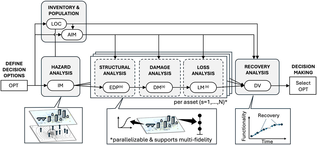
Figure 1. SimCenter framework for computational simulation in natural hazards engineering.
A key advancement of the SimCenter’s framework is its ability to embed local-scale analyses within regional-scale simulations, allowing for detailed assessment of individual assets while maintaining a holistic perspective of broader impacts. This capability bridges traditionally siloed research areas, enhancing the interplay between localized and system-wide evaluations. The resulting framework enhances existing capabilities in five critical areas:
1. Formalize Input Data for Regional Simulations: The framework recognizes the critical role inventory and event information play in regional studies. It includes a formal description of the key variables, including Location (LOC), Asset Information Model (AIM) for inventories, and Intensity Measures (IMs) for events. Through its modular architecture, the framework encourages research on the generation of robust inventories and studies that establish a link between expensive natural hazard event simulation outputs and event IMs (e.g., ground accelerations, wind speeds) corresponding to each asset while accounting for spatial dependencies. Research in these areas can ensure the coherent representation of assets and demands before structural analysis, damage estimation, and loss assessment.
2. Multi-Resolution Model Support: The flexible definitions for structural analysis, damage assessment, and loss estimation accommodate various levels of fidelity and various model resolutions within the same regional simulation. This modularity supports, for example,: (a) the efficient calculation of Loss Measures (LMs) directly from IMs by skipping structural and damage analyses; (b) the use of Engineering Demand Parameters (EDPs) and Damage Measures (DMs) without loss analysis when only response and damage information is needed; and (c) the calculation of damage and losses using detailed, high-fidelity analyses (e.g., finite element, computational fluid dynamics, etc.). The framework’s multi-resolution approach fosters benchmarking, calibration, and multi-fidelity studies within a single simulation environment.
3. Generalization Across Hazards: The framework maintains a standardized vocabulary and computational logic across multiple hazard types, fostering interdisciplinary collaboration and enabling multi-hazard simulations. By unifying methodologies across different hazards, the framework enhances interoperability and facilitates the integration of hazard-specific knowledge into a cohesive simulation environment.
4. Adaptability for Diverse Asset Types: Designed for versatility, the framework supports the analysis of various infrastructure assets, including pipelines, electrical transmission towers, and other critical infrastructure. The multi-resolution analysis approach allows for tailored model strategies across different asset classes while ensuring compatibility in response, damage, consequence, and recovery analyses.
5. Regional Recovery Simulation: A key framework enhancement assigns Decision Variable (DV) generation to a regional, systemic recovery analysis step. Unlike traditional PBEE, where loss analyses generated DVs, our framework’s loss analyses yield Loss Measures (LMs) limited to direct or immediate losses. This change aligns with recent literature recommending the consistent consideration of systemic effects for regional disaster impact assessments (Koliou et al., 2020). The recovery analysis module is designed to model post-disaster recovery, evaluating the progressive restoration of functionality and repair of infrastructure and communities over time.
Integrating recovery modeling with hazard characterization and inventory development, the framework (Figure 1) offers a comprehensive perspective on disaster resilience—from defining decision Options (OPT) to making decisions based on calculated Decision Variables. These enhancements to the SimCenter’s computational framework enable high-fidelity, regionally scalable simulations that support disaster risk reduction and resilience planning.
The SimCenter Framework is the foundation for an implemented simulation platform of versatile applications that can be customized and extended by researchers and practitioners in natural hazards engineering. We present below the key features of our simulation platform, illustrate the spectrum of supported use cases (Figure 2b) and highlight an example use case (Figure 2c).
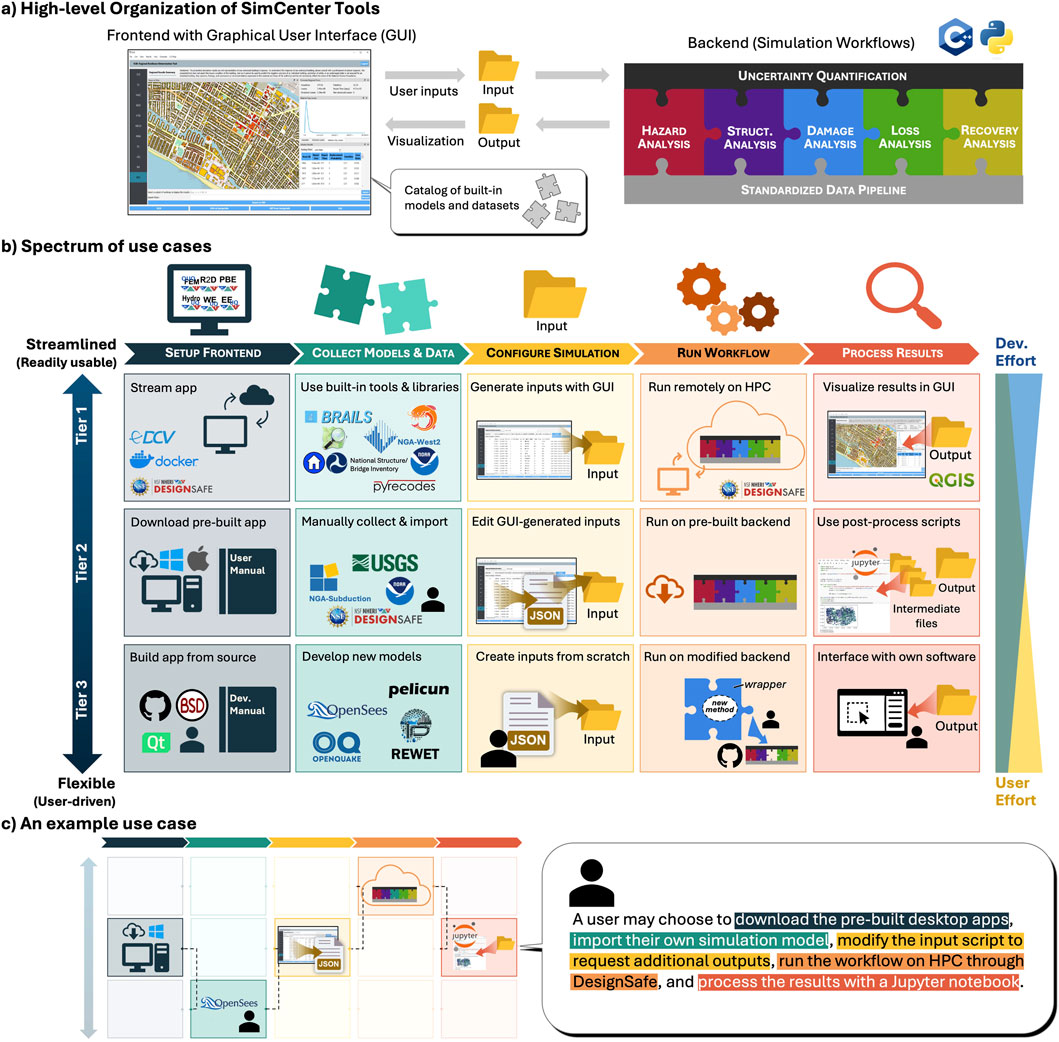
Figure 2. Spectrum of user-facing pipelines in the SimCenter computational simulation platform. (a) High-level organization of SimCenter tools. (b) Spectrum of use cases. (c) An example use case.
The following capabilities are highlighted in Figure 2:
Free and open-source software: SimCenter tools are publicly available in GitHub repositories (NHERI SimCenter, 2025b) and shared with a BSD 3-Clause license, ensuring broad accessibility and extensibility of the tools. Documentation, user guides, and examples housed on dedicated webpages for each tool facilitate platform adoption by researchers and practitioners.
Multiple ways to engage: Six front-end desktop applications provide access to select combinations of computational modules in the framework; each tailored to specific research problems. Figure 3 provides an overview of these applications and describes the types of problems and research questions they are designed to address. The desktop applications (i.e., front end) generate input files for a modular backend engine that performs calculations (Figure 2a). Users can bypass the desktop applications and interact directly with the backend through a command-line interface or custom scripts.
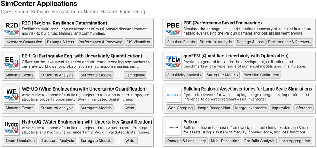
Figure 3. SimCenter applications and tools for natural hazards engineering.
Flexible Workflows: The modular architecture offers researchers diverse modeling options for each simulation step. Standardized interfaces and data schemas enable seamless integration of new or existing applications via wrappers without requiring modifications to the applications. This approach facilitates application contributions, even those with closed-source codes or restrictive open-source licenses.
Democratized High-Performance Computing: SimCenter tools support execution on both local machines and high-performance computing (HPC) clusters, enabling seamless transitions between small-scale test simulations and large-scale research investigations. Through collaboration with DesignSafe (Rathje et al., 2024), another NHERI facility, desktop application users can run simulations on the NSF-supported HPC resources at the Texas Advanced Computing Center.
Public Datasets and Libraries: The SimCenter tools and desktop applications facilitate data collection for setting up simulations by providing built-in interfaces with public datasets, such as building and bridge features from the National Structure and National Bridge Inventories (U.S. Army Corps of Engineers, 2023; FHWA, 2023), ground motion records from the PEER Next-Generation Attenuation database (Ancheta et al., 2014), and experimental wind tunnel test data from the Tokyo Polytechnic University Database (Tokyo Polytechnic University, 2025). Besides these automated approaches, the tools can parse several widely used file formats to facilitate importing event information, such as wind fields of recent hurricane events generated by Applied Research Associates and shared through a partnership between the National Institute for Standards and Technology (NIST) and DesignSafe (Levitan, 2020), or USGS Shakemaps of recent earthquakes (Wald et al., 2003). The SimCenter has also initialized new public libraries, such as the Damage and Loss Model Library (NHERI SimCenter, 2025a) and the CFD Simulation Library (NHERI SimCenter, 2025c), that are seeded with models and data and directly connected with our tools and applications.
Integrated Research Tools: Several commonly used research programs and packages are integrated into the simulation platform, including Dakota (Adams et al., 2020), OpenQuake (Pagani et al., 2014), OpenSHA (Field et al., 2003), OpenSees (McKenna et al., 2000), and OpenFOAM (Jasak, 2009); emerging software tools continue to be added based on user needs, e.g., pyrecodes (Blagojević and Stojadinović, 2025) and REWET (Naeimi and Davidson, 2024). The SimCenter has also developed two standalone research tools to fill important gaps: BRAILS++ for inventory generation (Cetiner et al., 2025) and Pelicun for damage and loss assessment (Zsarnoczay et al., 2025a). These research tools are included in Figure 3 and described in detail in Sections 3.1 and 5.3, respectively.
Access to Detailed Outputs: Desktop applications provide summary results for quick, visual interpretation. Further exploration of results is available with all intermediate and final outputs, which are organized in several files using standardized data schemas to support comprehensive post-processing and detailed research analyses.
The SimCenter simulation platform and the applications and tools featured in Figure 3 support the following types of numerical analyses:
Uncertainty Quantification: The architecture of our simulation platform and the interface of each SimCenter tool are designed to encourage and facilitate probabilistic analyses. Every component of our workflows can handle uncertain variables and multiple plausible models to allow consideration and propagation of aleatoric and epistemic uncertainties. quoFEM (McKenna et al., 2025c) operationalizes this foundation and provides state-of-the-art, general-purpose uncertainty quantification features, such as various options for sensitivity analyses and model calibration. Advanced surrogate model training options - with a special focus on stochastic emulation (Zhong et al., 2023; Soize and Ghanem, 2016; Yi and Taflanidis, 2024) and adaptive design of experiments techniques (Yi and Taflanidis, 2023) - are available in quoFEM, as well as in the EE-UQ, WE-UQ, and HydroUQ desktop applications. The workflows enabled by PBE and R2D can leverage the trained surrogate models and use the uncertainty propagation capabilities of the simulation platform.
Local-scale Structural Analysis: Simulating the behavior of individual assets in high fidelity is a core feature of our platform. The following desktop applications focus on detailed local-scale simulations for earthquake, wind, and water hazards: EE-UQ (McKenna et al., 2024), WE-UQ (McKenna et al., 2025b), and HydroUQ (Bonus et al., 2025a). These applications connect with the relevant parts of our backend and leverage well-established tools, such as OpenSees and OpenFOAM, for numerical analyses. They also provide supporting features that automate seismic structural design (Guan et al., 2020; Ceballos and Arteta, 2022), help define boundary conditions for fluid dynamic analyses (Mackenzie-Helnwein et al., 2020), and guide users through complex meshing operations. The numerical models can be calibrated to results from NHERI experimental facilities and then used to generate virtual experiments. The common framework allows researchers to directly use the models developed in these local-scale analyses in larger, regional simulations or to calibrate more efficient, idealized models using the high-fidelity results as a reference.
High-Resolution Damage and Loss Assessment: High-resolution damage and loss assessment for individual assets is routinely used in earthquake engineering practice and plays a key role in advancing research on functional recovery simulation. There is interest in adopting these techniques in other hazard areas, especially in wind engineering. SimCenter developed the Pelicun tool (Zsarnoczay et al., 2025a) as a general-purpose damage and loss assessment engine and the PBE desktop application (Zsarnoczay et al., 2025b) to support education and research in high-resolution performance-based engineering. Our Damage and Loss Model Database (NHERI SimCenter, 2025a) collects, organizes, and shares damage and loss model parameters and metadata and makes them available for the workflows managed by the PBE and R2D applications.
Regional-scale Risk Studies: Many of the enhancements the SimCenter Framework provides aim to formalize and facilitate the application of state-of-the-art probabilistic models in regional-scale risk assessment. The local-scale structural analysis capabilities in our backend are complemented by the SimCenter developed module BRAILS++ (Cetiner et al., 2025) that handles the semi-automated creation of inventories. This is further complemented by tools for the automated generation of earthquake and hurricane event scenarios. The backend workflows and these complementary modules are all engaged by our R2D desktop application (McKenna et al., 2025a). This is our most sophisticated tool, integrating the QGIS platform to provide rich geographical visualization capabilities designed to lower the barrier of entry to regional risk studies.
Socioeconomic Impact and Recovery Modeling: The capability of our simulation platform to provide detailed asset, household, and damage information in a standardized format facilitates interfacing with emerging models for socioeconomic impact and the recovery of various infrastructure systems and services. We integrated the pyrecodes framework (Blagojević and Stojadinović, 2025) into our platform to provide a modular system-of-systems approach that is in line with the modularity of other parts of our backend and fosters an environment where many models can be featured and benchmarked to encourage exploration and exchange of ideas. The R2D desktop application provides convenient access to workflows that include functionality and recovery simulations for buildings and lifeline networks, and captures the impact on and behavior of households after a disaster.
By broadening the performance-based applications to support regional-scale modeling, multi-resolution analyses, multi-hazard applications, and diverse asset types, the SimCenter Framework allows comprehensive and integrated assessments of risk and resilience. Interest in these capabilities is found in a growing base of over 4,200 users, who have leveraged this framework through our desktop applications to execute over 87,000 simulations over the last 6 years. Users are also taking advantage of the flexibility of our applications, accessing Pelicun and BRAILS++ directly from the command line and through online Jupyter notebook environments. The following sections further explore the capabilities of this framework and highlight its applications in advancing the field of natural hazards engineering.
3 Inventories of the Built Environment and Communities
A critical first step in natural hazard risk analysis is characterizing the assets at risk. Understanding key characteristics is essential when modeling structural behavior and vulnerability under different hazards. For instance, assessing earthquake impacts on buildings requires data on building height, plan configuration, structural materials, and structural system type. Similarly, detailed wind and water damage assessments require information on building envelope geometry, finish materials, and openings. Most assessments require information related to details of the design and construction (e.g., lateral strength, load-path integrity, foundation anchorages), which are typically inferred from the year of construction. However, comprehensive datasets providing such granular details are rare, making the creation of regional-scale inventories a significant challenge. Beyond buildings, infrastructure systems such as roads, bridges, pipelines, and power grids require similarly detailed data for high-resolution damage and loss modeling. Additionally, socioeconomic assessments utilize household characteristics in their models, which are often protected and unavailable at the desired resolution.
Traditional catastrophe modeling approaches address data limitations by relying on aggregated asset characteristics to estimate disaster impacts at a city scale (FEMA, 2024b). While valuable, these models often lack the granularity needed for detailed vulnerability assessments or targeted interventions. The SimCenter prioritizes high-resolution studies that simulate the behavior of individual assets within regional-scale analyses, bridging local structural assessments with broader regional evaluations. This approach supports studies on specific asset vulnerabilities and community-level coping capacities.
Compiling such regional-scale inventories, however, remains a formidable task. In the U.S., the National Structure Inventory (NSI) and Hazus building inventory databases (U.S. Army Corps of Engineers, 2023; FEMA, 2024e) provide broad coverage but rely on approximations that limit their suitability for high-resolution modeling. While these resources are notable for their geographical coverage and completeness, many of the building characteristics they contain are inferred using broad approximations (U.S. Army Corps of Engineers, 2023), which lack the accuracy required for higher-resolution simulations (Sanderson and Cox, 2023). Some proprietary datasets offer better accuracy, but their high cost and variable quality pose challenges (Nolte et al., 2023). The SimCenter developed BRAILS++, an open-source Python framework for asset inventory creation, to address this gap by combining open data acquisition with advanced inference methods, democratizing access to high-fidelity regional inventory data.
BRAILS (Wang et al., 2021), an earlier version of BRAILS++, has been widely applied in research to automate the extraction of building attributes. Several studies leveraged BRAILS to generate high-fidelity building inventories for seismic and hurricane risk assessments, enabling large-scale structural classification and vulnerability modeling (Bassman et al., 2022; Kijewski-Correa et al., 2023; Roueche et al., 2022; Yu et al., 2020). Other research incorporated BRAILS into virtual testbeds for community resilience (Enderami et al., 2023) and integrated it with computational fluid dynamics simulations to improve post-hurricane damage assessments (Kim et al., 2024).
BRAILS has contributed to transportation network resilience modeling (Virtucio et al., 2024). It has also supported 3D urban modeling and energy efficiency initiatives by automating building identification for energy retrofits (Liu et al., 2024; Shen et al., 2024). Across these studies, BRAILS consistently enhances large-scale data acquisition, enabling more accurate, scalable, and automated analyses in disaster risk management and urban resilience planning. The tool also inspires research in building inventory generation, as demonstrated by Gouveia et al. (2024) and Pan et al. (2024).
3.1 The BRAILS++ framework
The BRAILS++ framework significantly advances regional-scale studies by bridging gaps in public datasets and enabling high-resolution modeling, which, in turn, supports more accurate disaster risk assessment and resilience planning (Du et al., 2023). As shown in Figure 4, BRAILS++ provides modular workflows for generating inventories by integrating diverse data sources, including public datasets, features extracted from imagery, and ruleset-based inference models. In BRAILS++, an asset inventory consists of geographically referenced points, line-strings, or polygons, each annotated with key attributes. To build these inventories, the data scrapers in BRAILS++ interact with web servers in an automated manner and directly retrieve asset information from public datasets to create an inventory blueprint suitable as a starting point for regional-scale analysis.
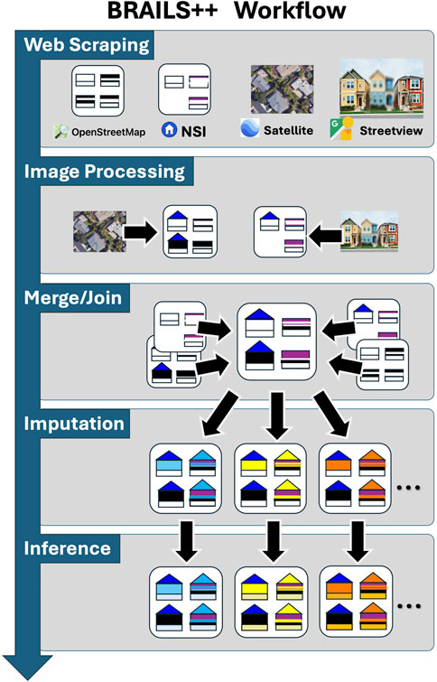
Figure 4. Illustration of a workflow for generating a building inventory using various BRAILS++ modules.
Key datasets accessed through BRAILS++ include FEMA’s USA Structures (FEMA, 2022), Microsoft Footprints (Microsoft, 2022), Overture Maps (Overture Maps Foundation, 2023), OpenStreetMap (OpenStreetMap contributors, 2017), the U.S. Army Corps of Engineer’s NSI, TIGER/Line roadway data (U.S. Census Bureau, 2024), FHWA’s National Bridge and Tunnel Inventories (FHWA, 2023; FHWA, 2024), ASCE REST services for design loads (ASCE, 2025), and HIFLD infrastructure data (U.S. Department of Homeland Security, 2024). SimCenter holds annual workshops on incorporating local datasets (e.g., tax assessor and permit data) into regional-scale hazard assessment studies, and BRAILS++ provides utilities for processing such custom datasets. Despite their value, these datasets often contain incomplete or inconsistent information, requiring further enhancement to address the corresponding uncertainties in these high-resolution inventories. BRAILS++ incorporates methods for handling missing data and enhancing the available datasets through modules that enable: 1) feature extraction from images; 2) inventory merging; 3) statistical imputation; and 4) data inference.
1. Feature Extraction from Images: Publicly available imagery from Google Street View (Anguelov et al., 2010), Mapillary (Mapillary contributors, 2020), and NHERI RAPID reconnaissance missions (Berman et al., 2020) can help provide up-to-date asset details. BRAILS++ employs neural networks and vision-language models to extract features such as roof type, material, and construction details. Additionally, advanced models enhance inventory completeness by capturing more complex dimensional data such as roof height and pitch, window areas, and first-floor elevation. Each model is documented to provide information about the dataset it was trained on and its performance in verification tests. We also provide guidance for applying transfer learning techniques to adjust pre-trained models to a new geographic context, if needed.
2. Inventory Merging: BRAILS++ enables merging datasets to resolve discrepancies and consolidate asset information. This process accounts for spatial inconsistencies (e.g., misaligned footprints and parcel boundaries) and integrates metadata from multiple sources to create a unified inventory. Standardized merging techniques establish correspondence between geometries and prioritize data sources based on their reliability. The resulting dataset contains unique assets, each with a specific geographic reference and integrated metadata from the combined data sources.
3. Imputation to Complete Data: Since inventories are often incomplete, BRAILS++ employs statistical imputation methods to fill the gaps and generate complete datasets. Techniques such as K-Nearest Neighbors imputation are available to estimate missing values based on spatial and structural similarities (e.g., using information from adjacent buildings with the same structural system and construction year). Each imputation technique provides several plausible values for the missing features based on the available data, supporting the creation of several plausible inventory realizations (also termed “possible worlds”). These allow researchers to capture and propagate inventory uncertainties through probabilistic regional simulations.
4. Inference to Add Features: Some critical asset attributes, such as roof-to-wall connections for wind vulnerability assessments, are rarely documented and typically missing for all assets in available datasets. BRAILS++ inference engines rely on rule-based and probabilistic models to estimate these missing attributes. For instance, building codes applicable at the time of construction can be used to infer typical connection details (Kijewski-Correa et al., 2022). Existing inference modules build on such code-based assignments and the rules recommended in the Hazus Inventory Manual (FEMA, 2024f) to add features necessary for regional simulations following the Hazus earthquake and hurricane methodologies. Ongoing expansions of this module aim to cover additional hazard models and methods.
3.2 SimCenter testbeds
The SimCenter has been maintaining testbeds to inform the prioritization of development tasks through firsthand experience with the challenges involved in real-world regional simulations. These testbeds also serve as environments for evaluating inventory generation models and provide benchmarking opportunities for high-fidelity simulations. Our first-generation testbeds in the San Francisco Bay Area, CA, Atlantic County, NJ, and Lake Charles, LA (Figure 5) are documented online (NHERI SimCenter, 2025d), including references to online repositories that archive the corresponding datasets. A new second generation of testbeds is under development, focusing on complex infrastructure systems and multi-hazard problems. Based on available inventory data, historical hazard events, and stakeholder interest, the San Francisco and Lake Charles testbeds will be updated, and Fort Myers, FL, will be developed as a new location.
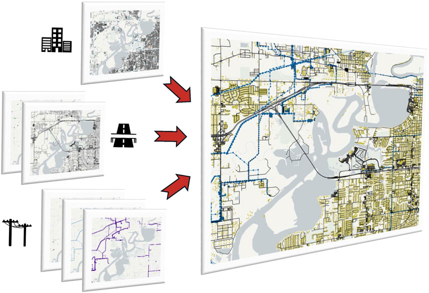
Figure 5. The process of creating the building, transportation, and power infrastructure inventories for Lake Charles, LA. Each tile details specific asset attributes or components, while the rightmost tile presents an overview of the assembled inventory.
The SimCenter developed a standardized data schema for asset inventories to facilitate the sharing and re-use of such data. Regular updates to testbed inventories provide high-quality datasets for research investigations, supporting studies on community resilience (Enderami et al., 2022; 2023) and regional risk assessments (Bassman et al., 2022; Kijewski-Correa et al., 2023). Researchers have used testbeds to evaluate damage inference models (Sheibani and Ou, 2020; Wang et al., 2024b) and optimize post-earthquake reconnaissance and recovery planning (Cheraghi et al., 2024; Wang et al., 2024b). They also serve as a platform to study the impact of infrastructure interdependencies (You et al., 2023a) and resource constraints on resilience (Blagojevic and Stojadinovic, 2022), while enabling assessment of advanced structural systems at the regional scale (You et al., 2023b).
4 Natural hazard events
Hazard analysis quantifies the likelihood and severity of natural hazard scenarios. The SimCenter extends the concept of an Intensity Measure (IM) from the PBEE framework to any measure describing hazard severity at a given location. An IM can be a scalar, such as peak 1-s spectral acceleration, or a vector, such as a spectral acceleration time history. High-resolution local analyses often require complete time histories provided as such vector IMs, which are essential for capturing time-evolving effects and cascading damages.
A regional event in the SimCenter framework is defined by an IM field—a continuous random field discretized geographically using a grid and probabilistically with IM samples at each grid point (Figure 6). These samples are correlated across locations and IM types, preserving essential dependencies for robust regional risk assessment. The SimCenter has developed a GeoJSON-based data schema to store these IM fields. This hazard-agnostic schema enables multi-event simulations, such as combined wind and storm surge in hurricanes, and facilitates multi-hazard and climate adaptation studies.
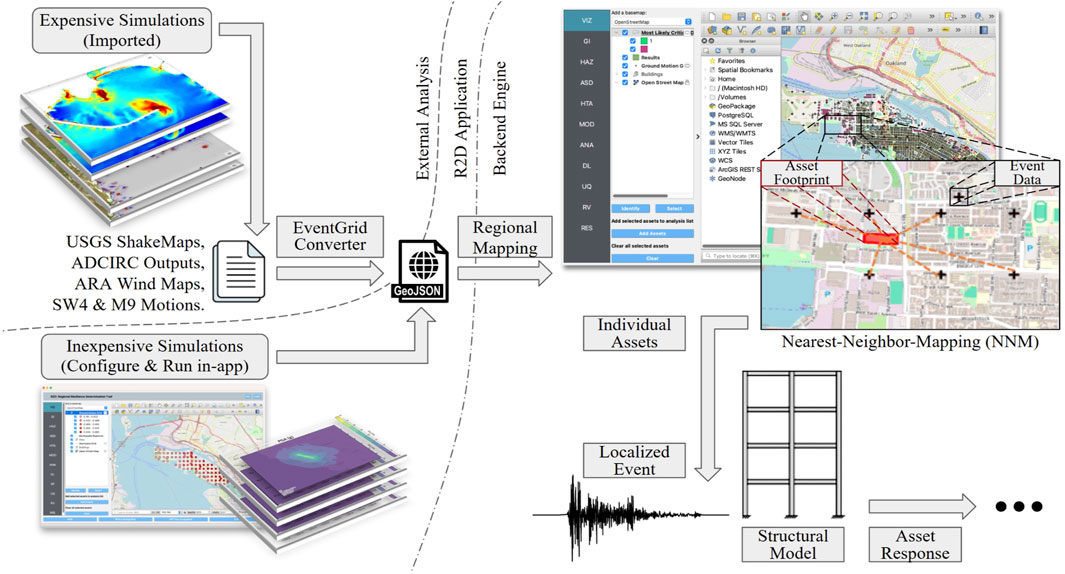
Figure 6. Overview of Hazard Analysis capabilities in SimCenter’s simulation platform (Illustrative examples of expensive simulations based on Lynett et al., 2017).
Computationally intensive simulations, such as regional earthquake rupture and subsurface wave propagation (McCallen et al., 2021; Frankel et al., 2018), large-scale ocean wave propagation and tropical storm surge models (Berger and LeVeque, 2023; Vijayan et al., 2023), and weather simulations (Skamarock et al., 2008) all require highly specialized modeling expertise and computational resources that fall outside the purview of the SimCenter, but are pertinent to enabling regional-scale risk studies.
The SimCenter offers interfaces to integrate outputs from established external models directly into its framework, avoiding the need to support or deploy third-party software. These interfaces enable users to seamlessly map high-fidelity simulation data—from sources like USGS ShakeMaps (Wald et al., 2003), SW4 and M9 simulated ground motions (Petersson et al., 2023; Sjögreen and Petersson, 2012; Frankel et al., 2018), ADCIRC (Luettich et al., 1992) storm surge outputs, and ARA wind maps (Levitan, 2020)—into our GeoJSON format, facilitating interoperability and data re-use. Users can also extend the platform by contributing interfaces for other external data schemas.
4.1 Computationally efficient hazard event simulations
Researchers often prefer the flexibility to choose the hazard scenarios for their study rather than using state-of-the-art, computationally expensive simulations of pre-defined scenarios. To support these needs, the SimCenter provides efficient, idealized event models that balance accuracy with usability. These tools lower the barrier to entry by reducing computational demands and required domain expertise while maintaining scientific rigor.
The SimCenter’s R2D desktop application includes the following tools for this purpose:.
- The Earthquake Event Simulation Tool interfaces with existing, well-established solutions, such as OpenQuake (Pagani et al., 2014), OpenSHA (Field et al., 2003), and the PEER NGA ground motion database (Ancheta et al., 2014). Its user interface provides a step-by-step approach to generating earthquake event intensity measures (Figure 7a). It facilitates selecting ruptures from earthquake rupture forecast results, choosing models for ground motion attenuation, spatial correlation, and secondary hazards, including landslides and liquefaction. An optional last step automatically selects and scales a set of ground motion records from the PEER NGA database to match calculated intensity measure fields.
- The Hurricane Wind Simulation Tool provides recent historical hurricane track data taken from the IBTrACS database (Knapp et al., 2010; Gahtan et al., 2024) and uses a probabilistic hurricane simulation method contributed to our framework by Snaiki and Wu (2017a), Snaiki and Wu (2017b) to simulate the time-evolving wind field as the hurricane moves along its track (Figure 7b). Users can also input custom hurricane tracks and terrain roughness through CSV and GeoJSON files.
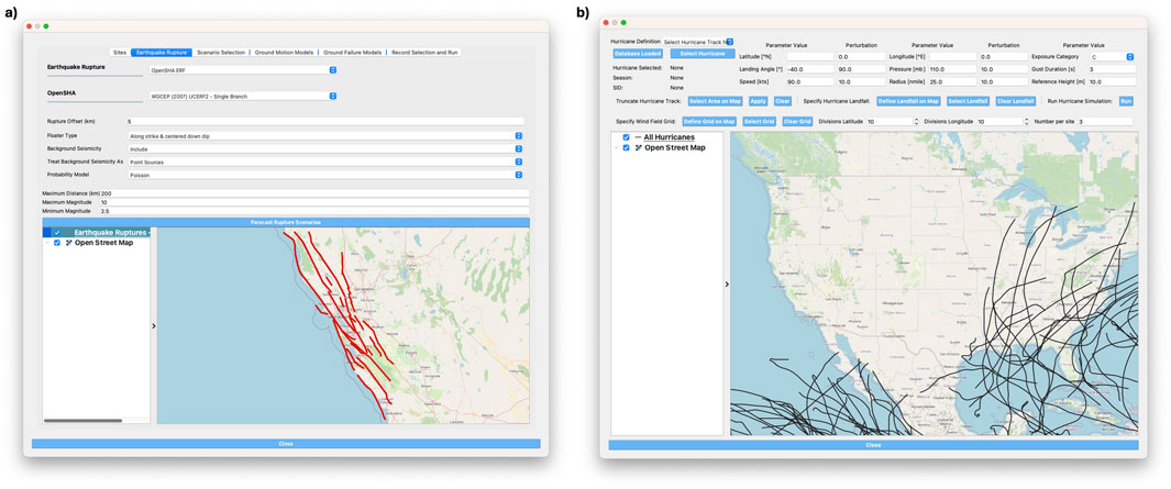
Figure 7. Earthquake Event Simulation (left) and Hurricane Event Simulation (right) tools support efficient simulation of intensity measure fields for user-defined scenarios.
4.2 Regional hazard mapping
Regional hazard event grids often do not align with asset locations, requiring an additional mapping step, referred to as Regional Mapping in Figure 6. The mapping process is event-specific, as some events provide only scalar IM values at mesh points, while others offer vectors of time series. For vector IMs, the underlying approximations used to derive coarse-mesh results introduce challenges in generalizing a mapping approach across all regional hazard event grids.
The SimCenter provides several mapping solutions and is working with researchers to address this challenge:
Nearest Neighbor Mapping (NNM): For scalar IM fields (and as a simplified approach for vector IMs), the SimCenter provides the NNM tool, which efficiently maps regional event data onto large asset inventories. This method utilizes distance-based interpolation for scalar IMs and iterative probabilistic sampling for time histories. The approach approximates a multi-IM field as a smooth hypersurface between grid points, preserving spatial correlations in the IM field.
Physics-Based Multi-Scale Hazard Event Integration: The SimCenter is actively integrating existing multi-scale hazard event simulation approaches. These approaches are useful when the output of the large-scale event simulation is lacking both the spatial and temporal resolution needed to perform robust response simulations for each asset in the region. The approaches taken are hazard-specific:
- Earthquake Simulations: Regional earthquake simulation efforts focus on integrating SimCenter tools with physics-based ground motion databases developed for seismically active regions in the United States and beyond. These databases leverage simulations based on finite-element methods (e.g., Hercules; Taborda et al., 2010), finite-difference methods (e.g., SW4; Petersson et al., 2023), and broadband (Green’s function) approaches (e.g., Shaker Maker, SCEC-BBP; Abell et al., 2022; Maechling et al., 2015). To support applications at locations between grid points, SimCenter tools are being connected to APIs such as M9 (Frankel et al., 2018), Hercules Turkey (Zhang et al., 2021), and EQSIM (McCallen et al., 2021), which enable the retrieval of simulated ground motions at arbitrary locations. In parallel, domain reduction methods (DRM) (Bielak et al., 2003; Yoshimura et al., 2003) are being used to bridge large-scale regional wave propagation models with detailed local site-scale analyses. These efforts enable seamless integration of macro-scale seismic simulations with local geological modeling near critical assets, enhancing the fidelity of the simulations by incorporating higher frequencies, complex 3D soil conditions, and nonlinear soil-structure interaction effects (Pakzad et al., 2024; Zhang et al., 2019).
- Wind Engineering: Multi-scale wind engineering simulations will be facilitated by a new development in SimCenter applications that enables the interfacing of high-resolution local modeling applications with a global weather model. Similar to methods used for earthquakes, this approach interpolates between coarse grid points and incorporates higher frequency content. This allows for the utilization of real weather information as boundary conditions to drive high-fidelity local analyses of wind flow (Huang et al., 2024).
- Coastal Engineering: The SimCenter is exploring interfaces for ADCIRC simulations (Luettich et al., 1992) that integrate auxiliary software such as SWAN (2024) and STWAVE (Massey et al., 2011). This will enable coupling with sub-city-scale Boussinesq models, capturing refined coastal inundation, nonlinear wave interactions, and debris dynamics with increased fidelity (Renteria and Lynett, 2024).
Asset Incorporation in Large-Scale Hazard Simulations: Embedding regional assets directly into large-scale hazard simulations can eliminate the regional mapping step. This requires modifying workflows to extract Engineering Demand Parameters (EDPs) from larger-scale event-asset interactions, rather than from independent asset-specific calculations. For example, while a local-scale soil-structure interaction (SSI) model typically provides asset-specific results (e.g., floor accelerations for a single building), a city-wide SSI model (e.g., Wang et al., 2024a) or a computational fluid dynamics simulation of city-wide wind flow (e.g., Gu et al., 2023) shifts these analyses to the regional level, generating a joint EDP field. While these approaches enable high-resolution regional-scale analyses, they currently demand specialized expertise and significant computational resources due to the fine mesh required for local asset-scale hazard characterization. The SimCenter supports these methodologies by streamlining workflows and integrating outputs from large-scale physics-based simulations.
5 Asset Modeling and Damage Estimation
Given a probabilistic asset inventory and the probabilistic event IMs at each asset’s location, the next step is to determine how the assets respond to the demands induced by the event and to quantify the resulting damage (Figure 1). This process leverages extensive past research in earthquake, wind, and coastal engineering and integrates well-established computational tools, such as OpenSees (McKenna et al., 2000) and OpenFOAM (Jasak, 2009). SimCenter supports the robust modeling of response and damage through contributions in the following four areas: (i) Calibration, Validation and Model Development; (ii) Structural Analysis with Automated Workflows; (iii) Damage Analysis with Pelicun; and (iv) Model and Simulation Databases.
5.1 Calibration, validation, and model development
Before conducting simulations for large asset portfolios, it is essential to establish confidence in one’s ability to make accurate predictions. Reliable simulation outcomes depend on ensuring that the numerical models can capture real-world behavior. Building such confidence requires a combination of experimental testing and computational modeling, as these activities are complementary in refining numerical methods and increasing confidence in predicted responses. Many features in the quoFEM application are specifically designed to strengthen the connection between these activities, enabling researchers to utilize experimental data for robust model calibration (Figure 8). quoFEM provides a convenient interface to both deterministic and probabilistic calibration techniques from the Dakota optimization and uncertainty quantification tool (Adams et al., 2020). For deterministic calibration, it includes gradient-based methods tailored for solving nonlinear least-squares minimization problems (Dennis et al., 1981; Meza et al., 2007), as well as gradient-free approaches for handling non-smooth, non-convex problems (Gray and Kolda, 2006).
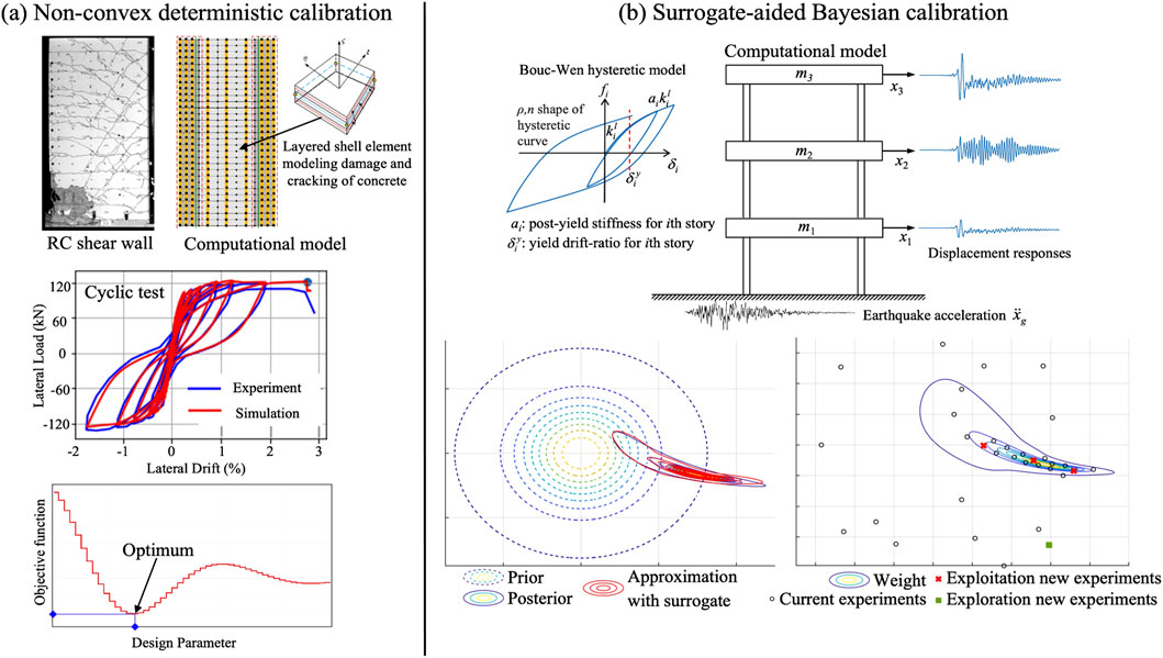
Figure 8. Examples of challenging calibration problems facilitated by the quoFEM desktop application. (a) Non-convex, deterministic calibration. (b) Surrogate-aided Bayesian calibration.
Deterministic methods alone cannot fully capture uncertainties in calibrating model parameters. Bayesian calibration provides a probabilistic framework for quantifying uncertainty (Beck and Katafygiotis, 1998; Vrugt et al., 2009; Ching and Chen, 2007; Wu et al., 2018; Kurumbhati et al., 2024). However, for complex models with multiple parameters, Bayesian calibration can become computationally prohibitive. To reduce the computational cost associated with Bayesian calibration of detailed models, we have developed a hybrid approach that integrates surrogate-assisted sampling within a sequential Monte Carlo framework (Taflanidis et al., 2025). Gaussian process regression is used as the surrogate model, iteratively refined by selecting training points that best inform the approximation of the target posterior density. Convergence is evaluated by comparing posterior approximations across successive iterations, and if unmet, the surrogate is further refined using an adaptive design of experiments with a weighted acquisition function that balances exploitation and exploration for improved efficiency and robustness. The method is illustrated in Figure 8b.
Beyond calibration, quoFEM provides capabilities for global sensitivity analysis methods (Weirs et al., 2012; Adams et al., 2020; Hu and Mahadevan, 2019; Jung and Taflanidis, 2023) to support critical evaluation of existing models and the identification of their most impactful inputs and parameters. Through these capabilities, we aim to support the broader research community in developing validated, uncertainty-aware predictive models. quoFEM has been used for sensitivity analysis to assess OpenSees seismic models (Yi et al., 2022), sediment transport dynamics (Feehan et al., 2023), and RC column behavior (Güngör et al., 2023). Bayesian calibration applications include refining the PM4Sand liquefaction model (Satish et al., 2022) and estimating LVL panel properties via vibration-based methods (Opazo-Vega et al., 2025). Researchers have also leveraged quoFEM for uncertainty propagation inprobabilistic assessments, such as modeling uncertainties in force-limiting connections (Astudillo et al., 2023), RC wall fractures (Navarro Carranza et al., 2025), and seismic risk of bridge towers (Taslimi and Petrone, 2024). It has also supported probabilistic evaluations of hydrodynamic forces on bridges (Pervaiz, 2022) and mechanical properties of geopolymer composites (Artyk et al., 2024).
The advanced uncertainty quantification techniques supported by our local-scale applications (i.e., EE-UQ, WE-UQ, and HydroUQ) facilitate the creation of high-quality numerical models that can capture and faithfully reproduce the complex structural behaviors experienced when assets in the built environment are pushed near and beyond their capacity by extreme events.
We foster strong collaboration between simulation and testing, especially in wind and coastal engineering, through the development of validated digital models of experimental laboratories to facilitate running virtual experiments. These validated digital models form the basis for future experimental facility digital twin initiatives–a highly complex but promising endeavor. The numerical simulations are either performed ahead of the laboratory tests, e.g., to aid in design-of-experiments or to participate in a blind study, or they are performed afterward, i.e., calibrated to the test data, to generate additional, complementary results. The WE-UQ and HydroUQ applications allow users to create such virtual experiments for wind tunnels and wave flumes. These tools support streamlined workflows for multiple experimental facilities, including the Wall of Wind Experimental Facility at Florida International University, the Boundary Layer Wind Tunnel Facility at the University of Florida, the Wind Tunnel Facility at Tokyo Polytechnic University, the Large Wave Flume and Directional Wave Basin at Oregon State University’s Hinsdale Wave Research Lab (Bonus, 2023; Lewis et al., 2023), and the Tsunami Wave Basin at Waseda University (Bonus et al., 2025b). The digital flume models, within a SimCenter workflow, include: (i) the modifiable geometric layout of the facilities with sensor placements pre-set to replicate prior experimental works; (ii) automation of most of the setup for boundary conditions and meshing in typical use-cases; (iii) deployment and execution of the corresponding computational fluid dynamics simulations on a remote HPC cluster: and (iv) the post-processing and visualization of the results locally.
Numerical results for a digital wave flume or wind tunnel are typically validated against stochastic sets of experiments (Figure 9). Thresholds for validation are defined by meeting appropriate error metric thresholds that support the hypothesis that dominant phenomena studied within the facility for a given hazard are numerically resolved. Error metrics are most often based on simple time-series comparisons, e.g., root-mean-square error (RMSE), or scalar comparison, e.g., percent difference of maximum values, for a set of field quantities. These include velocity, acceleration, and pressure in fluid flow, and additional measurements of displacement for wave and debris hazards (e.g., free-surface displacement, debris displacement). Quantities are measured at a finite sampling rate for multiple locations throughout the physical facility, which the pre-validated digital wave flumes and wind tunnels aim to replicate for select experiment sets. Internal multi-model validation of digital wave flumes has been demonstrated through several examples. The high performance Celeris wave solver (Tavakkol and Lynett, 2020; (Renteria and Lynett, 2025; Renteria et al., 2025) and the ClaymoreUW Material Point Method (MPM) (Wang et al., 2020; Bonus, 2023; Bonus and Arduino, 2025) event modules within HydroUQ can reproduce pertinent aspects of experiments at Oregon State Univeristy’s Large Wave Flume and Directional Wave Basin (Park et al., 2021; Mascarenas, 2022; Koh et al., 2025). Additionally, external multi-model validation of digital wave flumes is ongoing. A recent comparative analysis paper (Bonus et al., 2025b) thoroughly validated HydroUQ’s MPM digital wave flume module against external results from the Finite Volume Method (FVM) in STAR-CCM+ and Smoothed Particle Hydrodynamics (SPH) in DualSPHysics, with pertinent data in DesignSafe (Bonus, 2025). It found that our open-source digital wave flume features state-of-the-art capabilities for tsunami debris studies in Waseda University’s Tsunami Wave Basin, relative to contemporary numerical approaches for modeling stochastic experiments (Goseberg et al., 2016). Further, our digital wave flume demonstrated superior strong- and weak-scaling on DesignSafe’s high-performance computing systems, which are made available within our downloadable desktop applications.
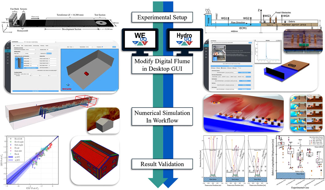
Figure 9. Virtual experiment workflows paralleled in the WE-UQ and HydroUQ desktop application for the University of Florida Wind Tunnel and the Waseda University Tsunami Wave Basin (Goseberg et al., 2016; Bonus, 2025; Bonus, 2025), respectively.
5.2 Structural analysis with Automated Workflows
Our work advances the use of established computational workflows by automating data exchange between tools and eliminating the need for manual intervention (Figure 10). This automation significantly improves the scalability of local-scale workflows, enabling the sophisticated analysis of large building portfolios in regional studies. Well-defined interfaces that specify inputs and outputs clearly for each module allow analysts to choose from a variety of options for each step and tailor workflows to the asset type and investigated problem. This is particularly important in performing computations at the regional scale, as it allows for different levels of fidelity:
1. High-Fidelity simulations are at one end of the computational spectrum, where a local-scale workflow is used for each asset, including vector IMs and a detailed structural model in a nonlinear response analysis. This approach leverages the shared simulation platform between local- and regional-scale analyses. The feasibility of such calculations was demonstrated in our study using the San Francisco Bay Area testbed, where 1.8 million buildings were analyzed, each with a finite element model and multiple nonlinear analyses to propagate structural and event uncertainties (Deierlein et al., 2020).
2. Moderate-Fidelity simulations typically sacrifice fidelity to reduce the amount of required building information and to increase computational efficiency. Simple models, such as the capacity spectrum for earthquakes (FEMA, 2024b) and pressure coefficients under wind loading (ASCE, 2022), can approximate EDPs for large inventories without the need for high-performance computing.
3. Surrogate-Aided simulations use pre-trained surrogate models to characterize the response, or even damage and losses, for assets. Surrogate modeling has become a widely used approach in natural hazards engineering over the last decade. It leverages advances in machine learning and recognizes the substantial benefits of replacing expensive physics-based models with approximate, data-driven ones that are trained to reproduce the expensive models’ input-output relationships. Such surrogates can be trained in either the quoFEM application, which provides general-purpose training capabilities, or using one of our local-scale desktop applications (i.e., EE-UQ, WE-UQ, HydroUQ). Surrogate models can provide various levels of fidelity depending on the quality of training data, the type of surrogating used, and how well the training data covers the application domain. In an optimal scenario, surrogates can approach the fidelity of detailed numerical models.
4. Zero-Fidelity approaches to structural analysis do not simulate structural response and directly assess damage and losses using the event IMs.
5. Multi-Fidelity simulations, applicable only in regional studies, employ high-fidelity models for a subset of assets and more efficient options for others. Figure 11 illustrates our vision for a streamlined interface in the platform, allowing users to assign inventory assets to various modeling approaches, thereby optimizing simulation fidelity. We envision models being automatically imported from shared libraries (Section 5.4) or supplied by the user. This approach poses research questions regarding the optimal distribution of computational resources to maximize the fidelity of Decision Variables in regional simulations. As multi-fidelity approaches gain adoption, the natural hazards engineering community will gradually learn more about the needs and opportunities for improving local-scale analyses, potentially influencing experimental research, driving new numerical model developments, and spurring surrogate modeling studies.
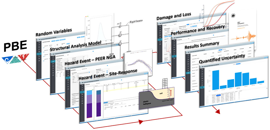
Figure 10. Illustrative example of a complex earthquake engineering workflow from the PBE desktop application.
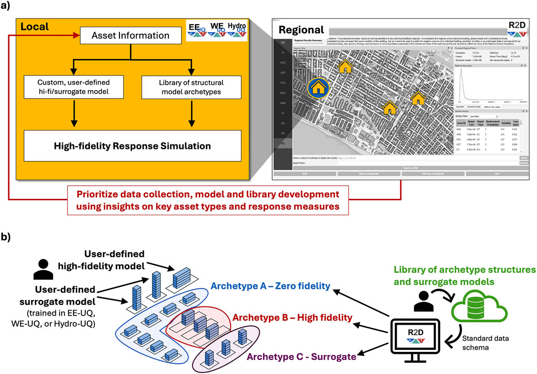
Figure 11. Tools and interfaces developed to streamline feedback between local-scale and regional-scale simulations. (a) Feedback between local and regional analyses. (b) Example multi-fidelity analysis setup.
5.3 Damage Analysis with Pelicun
The vulnerability of an asset is typically characterized by the likelihood of it being damaged. Component damages can be simulated directly in expensive numerical models that capture detailed material behavior and progressive failure of components (e.g., Galvis et al., 2022; Terashima et al., 2018). Such high-fidelity simulations are often challenging to perform even for individual assets due to the lack of information about important structural details required to define key model parameters. Considering and propagating the corresponding substantial uncertainty in model parameters renders simulations prohibitively expensive for most projects. The SimCenter simulation platform can support such expensive analyses when researchers wrap their simulations with interfaces to align with the input and output data specifications of the structural response simulation module. The continuous scalar damage outputs can be treated as EDPs and, if needed to be compatible with subsequent calculations of consequences and recovery, they can be mapped into Damage States (DS) in the Pelicun damage and loss simulation engine introduced below.
Researchers often use the concept of fragility functions as a scalable approach to balance data availability and fidelity in damage simulation. A fragility function is a probabilistic description of the demand severity that triggers a limit-state exceedance in a component, subassembly, or entire asset. Rather than simulating the mechanics of damage directly, fragility functions recognize a few important damage states and allow rapid evaluation of the likelihood of each at a given demand. As shown in Figure 1, the SimCenter aims to streamline these calculations through a Damage Analysis module that uses EDPs from the structural response or direct-damage simulations described earlier and classifies damages into a few damage states that are passed as DMs to the following Loss and Recovery Analysis modules.
Damage Analysis needs to characterize and propagate all important sources of uncertainty in demands (i.e., joint distribution of EDPs) and component characteristics (i.e., component quantities and fragilities) to be able to capture the low-probability, high-consequence outcomes with sufficiently high fidelity. This uncertainty quantification often requires a larger sample size than what is feasible to generate directly through traditional numerical simulation of structural behavior. Hence, probabilistic EDP models are fit to raw EDP results and they are used to generate a large EDP sample for subsequent calculations. High-resolution approaches in recent literature introduce further complexity to consider correlations between component capacities (Baker et al., 2024), model cascading damages (i.e., damage to one component triggers damage in another) (Hamburger et al., 2025), recognize changes in demands due to structural and nonstructural damage (Ouyang and Spence, 2019), and simulate the entire time history of damages to capture the behavior of components sensitive to load history (Ouyang and Spence, 2020; Abdelhady et al., 2022).
Existing damage simulation tools typically focus on single methodologies, with many being proprietary and closed-source (e.g., Verisk, 2025; HBRisk, 2025; ATC, 2018; FEMA, 2024a), preventing researchers from benchmarking or improving them. The few open exceptions often focus on low-resolution, aggregate assessments for large-scale studies (e.g., Pagani et al., 2014). Recognizing significant synergies among existing methodologies, we developed a unifying approach that integrates popular damage and loss assessment techniques. Building on the FEMA P-58 methodology, we generalized it across hazards, assets, and resolutions (Zsarnoczay and Deierlein, 2020). These developments are implemented in the Pelicun engine (Zsarnoczay et al., 2025a), which handles damage and loss assessment for both local-scale and regional-scale simulations within the SimCenter backend. Pelicun is instrumental in supporting the diverse structural, damage, and loss assessment workflows shown in Figure 12 within the SimCenter framework (Figure 1).
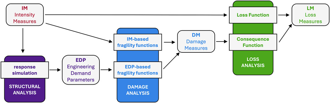
Figure 12. Workflow options in the Pelicun engine for damage and loss assessment.
Pelicun has been widely adopted for regional risk and resilience assessments across seismic and hurricane hazards, enabling high-resolution modeling of damage and losses (Dahal et al., 2025; Zhang et al., 2023; Kijewski-Correa et al., 2023; Khajwal and Noshadravan, 2024). Researchers have leveraged its flexibility in functional recovery analysis for diverse structural systems, including hybrid frames, steel moment frames, and isolated buildings (Rahgozar and Alam, 2023; Galvis et al., 2023; Blowes et al., 2023; AlHamaydeh et al., 2023). Its probabilistic framework has supported sensitivity studies on loss and recovery estimates (Kourehpaz et al., 2025; Banihashemi et al., 2024) and informed optimization-based design and decision-making for resilience (Issa et al., 2023; Pampanin et al., 2023; Pham and Becker, 2023). Studies have also applied Pelicun to assess the impact of rupture characteristics on seismic risk (Payyappilly et al., 2021; 2024) and quantify the benefits of retrofit strategies for vulnerable wood-frame houses (Welch et al., 2020), demonstrating its adaptability in integrating various loss assessment methodologies.
5.4 Model and Simulation Databases
The advent of the George E. Brown Jr, Network for Earthquake Engineering Simulation (Ramirez et al., 2020) established data sharing as the norm and set an example for the hazards research community in data re-use and dissemination, which continues in NHERI. Developing and sharing validated numerical models is essential to continue advancing our understanding of structural vulnerabilities and enhancing the design and retrofit of assets. High-fidelity numerical models of assets are important sources of synthetic reference data to evaluate, calibrate, and improve the efficiency of models to analyze a large number of assets in regional-scale studies. Such efficient approaches include reduced-order models and surrogates, as well as fragility functions for even more streamlined analyses. High-importance and unique, complex structures often lie outside the scope of available high-efficiency models and need to be directly analyzed using specific numerical models in multi-fidelity regional simulations (Figure 11). We believe their organization under shared model libraries will substantially improve our ability to realistically capture the impact of disasters on large metropolitan areas; we are actively building and maintaining libraries of models and data in the following areas:
1. Computational Fluid Dynamics Simulation Library: This repository archives the outputs and model data from high-resolution simulations conducted using WE-UQ, offering benchmark datasets for future research (Melaku and Bitsuamlak, 2024). The stored data for each simulation includes pressure tap locations, time-varying pressure coefficients at these locations, building geometry, and all relevant information related to the simulated wind condition. These datasets are analogous to those obtained from wind tunnel experiments (Ho et al., 2005; Tokyo Polytechnic University, 2025). The primary objective of this effort is to develop a comprehensive aerodynamic database using computational fluid dynamics for various building archetypes and exposures, which later can be queried using specific search criteria, facilitating their integration into uncertainty quantification workflows and the training of surrogate models.
2. Structural Response Model Library: We are curating a library of models for commonly used structural systems in earthquake engineering. These models will be stored with metadata that identifies key limitations, links to relevant publications, and enables researchers to utilize them immediately in our simulation platform. We envision a future extension of this library that includes surrogate models to replace expensive response simulations in regional studies. We are collaborating with researchers who develop such models and aim to establish a standardized schema for storing and sharing surrogates.
3. Damage and Loss Model Library: The generic data schema for fragility, consequence, and loss functions developed as part of the Pelicun engine described earlier is used in this library to collect and organize a broad range of models required for damage and loss simulations (NHERI SimCenter, 2025a). The library covers seismic, wind, and water hazards, various asset types and resolutions from component-scale to portfolio analysis (e.g., Hamburger et al., 2025; FEMA, 2012; FEMA, 2024d). The models are automatically bundled with Pelicun, but researchers have also leveraged them in studies that do not use Pelicun by directly interfacing with the library (e.g., Klepac et al., 2022).
6 Losses, performance, and recovery
Traditionally, damages and losses have been calculated with methodologies focusing on individual assets, and asset-specific results are used to estimate aggregate metrics in regional-scale studies. In catastrophe modeling, assets in large inventories are classified into a few archetypes, and the analyses are performed using archetype counts across geographic areas, such as census tracts. This approach is efficient because it requires only one assessment per archetype in each area, and it has been successfully used to capture overall trends and high-level consequences (Mitchell-Wallace et al., 2017). Despite these advantages, it is recognized in recent literature that such high-level approaches cannot provide the fidelity required to faithfully capture complex recovery processes of communities or identify opportunities for mitigating critical vulnerabilities in the built environment that have cascading impacts across a city’s infrastructure systems and services (Koliou et al., 2020).
The SimCenter leverages the high-resolution inventories and damage information supported by our simulation platform and designed the SimCenter Framework to support the probabilistic simulation of a regional-scale recovery process by regularly evaluating functionality and simulating the restoration of various systems in a region. These systems include buildings, transportation networks, water distribution systems, and electric power systems whose performance is critical for community resilience. Disruptions in road networks can delay emergency response and reconstruction efforts (Hackl et al., 2018), while failures in water and power distribution systems can significantly hinder both short-term coping and long-term recovery (Oikonomou et al., 2021). Interdependencies between these systems present significant challenges in model calibration and recovery simulation (He and Cha, 2018).
The pyrecodes framework (Blagojević and Stojadinović, 2025) is integrated into our platform to simulate recovery and manage infrastructure system models and interdependencies. pyrecodes models a region as a system-of-systems using generic supply-demand relationships, enabling a bottom-up simulation of complex infrastructure interdependencies (Figure 13). It employs an agent-based approach combined with resource-constrained discrete-event simulation to model recovery, evaluating resource allocation and asset restoration over time. In each time step, pyrecodes interfaces with other software to assess system performance and distribute resources. Since the performance of each system can depend on the performance of the others, this distribution step is not trivial. pyrecodes handles the optimization required to converge to an equilibrium in each time step, defining resources available for the restoration of each asset in each system. Regional recovery simulation occurs at the building and infrastructure component level, using recovery models that can range from simple asset-specific restoration curves to complex multi-step, resource-constrained models that account for impeding factors and building component repair. Restoration is tracked by advancing assets to higher functionality states as they recover, a process repeated until full restoration or a time limit is reached. Uncertainties are propagated by running a recovery simulation for each inventory-event-damage realization available from the preceding part of the workflow.
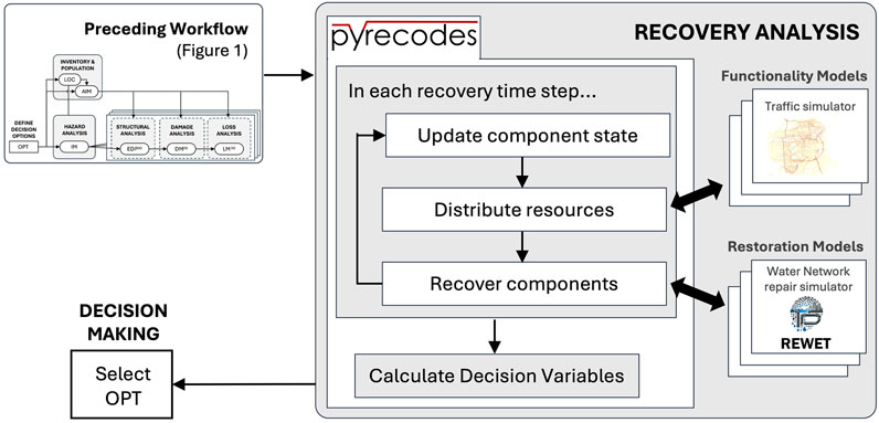
Figure 13. Conceptual overview of recovery analysis in the SimCenter Framework using pyrecodes and connected system-specific tools.
Several research studies have utilized our simulation platform via the R2D desktop application to carry out seismic and hurricane risk assessments (Angeles and Kijewski-Correa, 2022; 2023; Maky et al., 2024; Dahal et al., 2025) and to create network-based methods for assessing infrastructure vulnerability (Li et al., 2025; Oh et al., 2024). The platform also enabled post-disaster recovery modeling and the inclusion of socioeconomic impacts in regional studies (Wang et al., 2022; Mongold et al., 2024; Byun and Yi, 2024). The following subsections offer more details about the capabilities and opportunities within the SimCenter platform, focusing on risk analysis for buildings, infrastructure networks, and communities.
6.1 Buildings
Disaster impacts on buildings have been traditionally modeled using local-scale workflows even in regional-scale simulations. Such workflows typically yield Loss Measures (LM, see Figures 1, 12) using one of the following two calculation paths:
1) Simulate damage with fragility functions and evaluate the consequences of the resulting damage states using consequence functions. There are several advantages of this approach that enable high-fidelity calculations. Since the same underlying damage state information can be used in consequence functions for various LMs, the considerable partial correlations between LMs due to the underlying damage are directly captured. Utilizing domain experts for the calibration of each type of consequence function supports the development of a robust and comprehensive library. Despite the flexibility of this approach, libraries of functions are typically only prepared to represent consequences at a given location and time. For example, FEMA P-58 functions model losses in a Northern California location in 2011 (FEMA, 2012). If supporting data is available, consequence functions can be scaled in Pelicun to account for alternative conditions in another geographical location (e.g., labor and material costs, contractor availability) or at another point in time (e.g., different relative repair costs due to non-uniform inflation in the construction sector).
2) Calculate LMs directly using event intensity measures as inputs to loss functions. This approach is more efficient because it does not require response and damage simulation. Loss functions are typically calibrated to approximately capture the expected losses for a broadly defined group of building archetypes (Aljawhari et al., 2023). Although the widely used loss functions do not aim to capture the influence of design details and specific vulnerabilities, this is not an inherent limitation of the method. If each loss function is calibrated to a specific, detailed building configuration, a large set of functions can provide high-fidelity loss information for a building with various types of potential vulnerabilities (Welch and Deierlein, 2020). However, it is typically not feasible to prepare a comprehensive set of such high-fidelity loss functions for general-purpose regional simulation.
Pelicun, SimCenter’s damage and loss simulation engine introduced in the previous section, supports both of these calculation paths, and our Damage and Loss Model Library includes consequence and loss functions for commonly used calculation methodologies such as Hazus and FEMA P-58. Although these models focus on immediate, direct loss of monetary value (also referred to as repair cost, loss ratio, and even as monetary damage ratio in the literature), they also support the calculation of repair time and injury LMs.
The distinction between the time to repair damage in a building (i.e., reconstruction time) and the time it takes for a building to recover after an earthquake was already recognized by the original Hazus Earthquake Methodology. Recovery typically includes pre-repair delays, often termed 'irrational components’ or 'impeding factors’ (Comerio, 2006). Modeling these delays and the gradual recovery of building functionality has been an active research area in recent years. The SimCenter promotes functional recovery simulation efforts by supporting the open-source release of ARUP’s REDi methodology (Almufti and Willford, 2013) and integrating it into the PBE application. TREADS (Molina Hutt et al., 2022), another functional recovery simulation method, uses the Pelicun engine for damage and direct loss inputs. We are also contributing to the development of a Python version of the ATC 138 methodology (Cook et al., 2022), and aim to integrate it into our platform.
Considering each building in isolation is acceptable for direct losses, but it leads to unrealistic results when considering impeding factors and other systemic effects that are often correlated between buildings in the same geographical region. Our regional simulation workflow allows the pyrecodes tool to leverage damage and direct loss information from individual building analyses and directly simulate the availability and distribution of resources needed for repair financing, engineering design, permitting, and construction. This allows a shared recovery simulation for buildings by enhancing existing functional recovery simulation frameworks, as shown through the example of F-Rec (Terzic et al., 2021) by Blagojević et al. (2023).
6.2 Transportation networks
Transportation networks play a crucial role in post-disaster recovery; limited transportation access can significantly hinder repair and recovery efforts across infrastructure systems and building inventories. Therefore, to assess potential disruptions to community-wide recovery, it is essential to evaluate both the functionality of individual transportation infrastructure assets—based on their damage states from prior analyses—and the overall performance of the transportation network. To do so, an agent-based residual demand model for city-scale traffic analysis (Zhao et al., 2019) is integrated into our simulation platform, enabling the assessment of regional travel behavior following a natural hazard event. The origin-destination (OD) matrix is an essential component for such traffic simulations, and we are participating in the development of an automated method to estimate a post-event OD matrix based on the changes in the number of households in each locality due to damage to residential buildings. The restoration of transportation assets is modeled either using restoration curves from the Hazus Earthquake Methodology or with the F-Rec + iRe-CoDeS framework through pyrecodes. More complex restoration models will be integrated in the future.
6.3 Potable water networks
Water transfer and distribution networks serve potable water to households, industries, and other critical infrastructures (e.g., healthcare and food facilities) and enable post-event fire-fighting efforts. Limited potable water can critically affect households’ ability to shelter in place and disrupt the functioning of key facilities such as those needing water for firefighting (Arango et al., 2025; Davidson et al., 2023). Evaluating water access, however, involves more than establishing a direct connection between a water source and a target location. It requires hydraulic simulations that integrate detailed network characteristics such as flow, pressure, and component constraints.
REWET is an open-source tool developed by Naeimi and Davidson (2024) to streamline damage modeling and recovery of water distribution networks. REWET can simulate the functionality of a damaged network using WNTR (Klise et al., 2020) and the industry-standard EPANET solver (Rossman, 2000) to facilitate a fast, reliable and verified hydraulic simulation with flexible hydraulic leak-damage modeling. The R2D application can import the widely used EPANET input schema to define the characteristics of assets in the network. For recovery, REWET uses a generalized restoration plan structure that enables users to define recovery effort parameters—such as jobs (including their duration and effects on network elements), damage groups, and repair crews (including their initial locations, capabilities, and priorities). Simulating the pipe repair process is challenging due to the need to model damage discovery (i.e., damaged pipes are usually buried, and the damage may not be discovered if the pipes are dry). REWET uses a rule-based damage discovery method for buried pipes that considers the amount of leaking water at each damage location from the hydraulic simulation outputs. The detailed, explicit simulation of hydraulic performance and recovery in REWET provides robust estimates of water availability for researchers studying post-disaster recovery.
6.4 Electric power networks
Electric power not only serves business and household consumers but is also critical for the function of other infrastructure, such as potable water, communication, healthcare, and transportation (He and Cha, 2018). In recent years, the increasing dependency on electric power is being addressed by backup sources, e.g., backup generators for water pumps, hospitals, and communication towers, and solar panels and batteries for households (Cheng et al., 2024). However, the availability, reliability, and longevity of such solutions is highly heterogeneous (Ceferino et al., 2020; Ceferino and Lin, 2023). Similar to potable water disruptions, households can partially adapt to the lack of electric power service (Chakalian et al., 2018; Davidson et al., 2023), but the lack of service has a significant socio-economic impact (Bhattacharyya et al., 2021). Thus, the system performance and post-disaster recovery of electrical power networks are important components of the overall recovery and social and economic impact assessment for a natural hazard event.
Hazus (FEMA, 2024b), for instance, uses a simple recovery method based on time and initial damage to estimate the percentage of power consumers served in the area by a given substation. This efficient methodology is available in our simulation platform and allows users to address the problem at an aggregate level. More sophisticated approaches account for the redistribution of power, considering the redundancy of the power network. Cheng et al. (2024) proposed a Direct Current (DC) model using a connectivity optimization method. Ma et al. (2022) developed a framework for probabilistic simulation of power transmission networks using MATPOWER (Zimmerman et al., 2011) to solve an alternating current optimal power flow model. This latter approach provides more realistic results than a DC model, but requires more information about the network. The SimCenter is exploring the integration of such approaches while also facilitating the collection of the required input data for these calculations.
6.5 Communities
Modeling community impacts and recovery quantitatively requires human behavior and decision-making models that describe how households respond to the shock of the hazard event and subsequent challenges posed by the scarcity of resources and their unmet needs (Lindell and Prater, 2003; Comerio, 1997). The post-disaster experience of households is primarily dictated by the functionality of their housing units, which is dependent on many factors beyond structural performance. These additional factors include the availability of utilities as well as the timing and extent of financial and other support that can facilitate the recovery process (Peacock et al., 2006). For households that need to leave their homes, the availability of temporary shelter through public services and informal connections is critical in avoiding permanent displacement (Johnson, 2007; Levine et al., 2007).
The SimCenter simulation platform has provided damage information for research studies focusing on socioeconomic impacts and community resilience. The high-resolution building inventories and corresponding damage estimates enabled novel, agent-based approaches to capture the behavior of communities through emerging patterns from relatively simple household-scale agents (Costa et al., 2021; Alisjahbana et al., 2022). Besides studying the impact of disasters on the built environment, we also aim to support studies that focus on households. When focusing on the built environment, a researcher can simulate how the number of housing units where residents can shelter in place changes over time (Figure 14). Conversely, studying households could require information on how many times households need to move while coping with the disaster until they can rebuild their home. We aim to support research in this area through the integration of the household dislocation model by Sutley and Hamideh (2017), and the Adaptive Regional Input-Output model for the local economy based on the work of Hallegatte (2013). The streamlined interface provided by pyrecodes facilitates the expansion of the list of supported models and allows members of the research community to contribute without in-depth familiarity with our backend architecture.
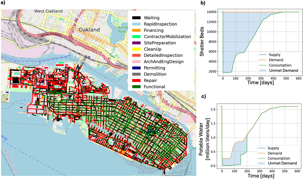
Figure 14. Recovery of housing units providing shelter in part of the San Francisco testbed, considering lifeline and building damages. (a) Recovery state of assets 2 months after an earthquake. (b) Recovery of shelter beds. (c) Recovery of potable water utility.
7 Concluding remarks
Computational simulation has become an essential tool in natural hazards engineering, enabling researchers to assess risk, evaluate mitigation strategies, and model disaster recovery processes with increasing accuracy. The NHERI SimCenter has contributed to this advancement by developing an open-source, modular framework that integrates high-fidelity simulations with high-resolution regional-scale assessments. Developed over the past decade, the platform provides tools that support collaboration across disciplines, leverage publicly available datasets, and integrate widely used modeling software to enhance the study of natural hazards. Testbeds demonstrate these capabilities and provide an environment for exploration and research discovery. The substantial impact of the SimCenter on research is illustrated in this paper by citing over 50 studies where SimCenter tools or testbeds were instrumental in achieving research objectives.
This paper has outlined the conceptual framework of the SimCenter simulation platform, enabling those studies, and illustrated its applications in hazard characterization, built environment modeling, structural response simulation, damage and loss estimation, and recovery modeling. The modular nature of the framework ensures flexibility and extensibility, allowing researchers to incorporate new methodologies and data sources as the field evolves. The SimCenter simulation platform currently has capabilities to address the impacts of earthquakes, hurricanes (wind and storm surge), and tsunamis, and the modular framework is readily extensible to other hazards such as wildfires, flooding, and compound events. As new challenges emerge in disaster risk management and resilience planning, continued collaboration and innovation in computational modeling will be essential for advancing the field and improving community resilience to natural hazards.
Data availability statement
Publicly available datasets were analyzed in this study. This data can be found here: https://github.com/NHERI-SimCenter.
Author contributions
AZ: Writing – original draft, Writing – review and editing. GD: Writing – original draft, Writing – review and editing. FM: Writing – original draft, Writing – review and editing. MS: Writing – original draft, Writing – review and editing. S-RY: Writing – original draft, Writing – review and editing. BC: Writing – original draft, Writing – review and editing. AS: Writing – original draft, Writing – review and editing. JZ: Writing – original draft, Writing – review and editing. JB: Writing – original draft, Writing – review and editing. AM: Writing – original draft, Writing – review and editing. SN: Writing – original draft, Writing – review and editing. PA: Writing – review and editing. RD: Writing – review and editing. CG: Writing – review and editing. SG: Writing – review and editing. AK: Writing – review and editing. TK-C: Writing – review and editing. LL: Writing – review and editing. MM: Writing – review and editing. SS: Writing – review and editing. ET: Writing – review and editing. AT: Writing – review and editing. MD: Writing – review and editing.
Funding
The author(s) declare that financial support was received for the research and/or publication of this article. The SimCenter was financially supported by the National Science Foundation under Grants CMMI-1612843 and 2131111. Any opinions, findings, and conclusions or recommendations expressed in this material are those of the authors and do not necessarily reflect the views of the National Science Foundation.
Acknowledgments
We would like to acknowledge the substantial value added to our simulation platform through collaboration with many faculty, post-doctoral researchers, students, and staff over the past 9 years, as well as facilities and institutions within and beyond NHERI and other federal and private sector partners.
Conflict of interest
The authors declare that the research was conducted in the absence of any commercial or financial relationships that could be construed as a potential conflict of interest.
The author(s) declared that they were an editorial board member of Frontiers, at the time of submission. This had no impact on the peer review process and the final decision.
Generative AI statement
The author(s) declare that no Generative AI was used in the creation of this manuscript.
Publisher’s note
All claims expressed in this article are solely those of the authors and do not necessarily represent those of their affiliated organizations, or those of the publisher, the editors and the reviewers. Any product that may be evaluated in this article, or claim that may be made by its manufacturer, is not guaranteed or endorsed by the publisher.
References
Abdelhady, A. U., Spence, S. M. J., and McCormick, J. (2022). Risk and fragility assessment of residential wooden buildings subject to hurricane winds. Struct. Saf. 94, 102137. doi:10.1016/j.strusafe.2021.102137
Abell, J. A., Crempien, J. G. F., and Recabarren, M. (2022). ShakerMaker: a framework that simplifies the simulation of seismic ground-motions. SoftwareX 17, 100911. doi:10.1016/j.softx.2021.100911
Adams, B. M., Bohnhoff, W. J., Dalbey, K. R., Ebeida, M. S., Eddy, J. P., Eldred, M. S., et al. (2020). Dakota, a multilevel parallel object-oriented framework for design optimization, parameter estimation, uncertainty quantification, and sensitivity analysis: version 6.12 user’s manual. Sandia National Laboratories, Tech. Rep.
AlHamaydeh, M., Maky, A., and ElKafrawy, M. (2023). Probabilistic incremental dynamic analysis for seismic isolation systems through integration with the NHERI-SimCenter performance-based engineering application. Buildings 13 (6), 1413. doi:10.3390/buildings13061413
Alisjahbana, I., Moura-Cook, A., Costa, R., and Kiremidjian, A. (2022). An agent-based financing model for post-earthquake housing recovery: quantifying recovery inequalities across income groups. Earthq. Spectra 38 (2), 1254–1282. doi:10.1177/87552930211064319
Aljawhari, K., Gentile, R., and Galasso, C. (2023). Simulation-based consequence models of seismic direct loss and repair time for archetype reinforced concrete frames. Soil Dyn. Earthq. Eng. 172, 107979. doi:10.1016/j.soildyn.2023.107979
Almufti, I., and Willford, M. (2013). “Resilience-based earthquake design initiative (REDiTM) rating system,”. San Francisco, CA.
Ancheta, T. D., Darragh, R. B., Stewart, J. P., Seyhan, E., Silva, W. J., Chiou, B. S. J., et al. (2014). NGA-West2 database. Earthq. Spectra 30 (3), 989–1005. doi:10.1193/070913eqs197m
Angeles, K., and Kijewski-Correa, T. (2022). Data-driven framework for automated simulation of wind and windborne debris effects for hurricane regional loss estimation. J. Wind Eng. Industrial Aerodynamics 230, 105167. doi:10.1016/j.jweia.2022.105167
Angeles, K., and Kijewski-Correa, T. (2023). Advancing parcel-level hurricane regional loss assessments using open data and the regional resilience determination tool. Int. J. Disaster Risk Reduct. 95, 103818. doi:10.1016/j.ijdrr.2023.103818
Anguelov, D., Dulong, C., Filip, D., Frueh, C., Lafon, S., Lyon, R., et al. (2010). Google street view: capturing the world at street level. Computer 43, 32–38. doi:10.1109/MC.2010.170
Arango, T., Baker, M., and Bogel-Burroughs, N. (2025). ‘Completely dry’: how Los Angeles firefighters ran out of water. N. Y. Times.
Artyk, Z., Kuan, Y., Zhang, D., Shon, C. S., Ogwumeh, C. M., and Kim, J. (2024). Development of engineered geopolymer composites containing low-activity fly ashes and ground granulated blast furnace slags with hybrid fibers. Constr. Build. Mater. 422, 135760. doi:10.1016/j.conbuildmat.2024.135760
ASCE (2022). ASCE/SEI 7-22: minimum design loads and associated criteria for buildings and other structures. Am. Soc. Civ. Eng. Reston, VA.
ASCE (2023). Prestandard for performance-based wind design, 1. Reston, VA: American Society of Civil Engineers. doi:10.1061/9780784484739
ASCE (2025). ASCE hazard tool. Available online at: https://ascehazardtool.org (Accessed February 26, 2025).
Astudillo, B., Rivera, D., Duke, J., Simpson, B., Fahnestock, L. A., Sause, R., et al. (2023). Modeling uncertainty of specimens employing spines and force-limiting connections tested at E-defense shake table. Earthq. Eng. and Struct. Dyn. 52 (14), 4638–4659. doi:10.1002/eqe.3976
ATC (2018). PACT: performance assessment calculation tool - version 3.1.2. Redwood, CA: Applied Technology Council. Available online at: https://femap58.atcouncil.org/pact (Accessed March 6, 2025).
Attary, N., Unnikrishnan, V. U., van de Lindt, J. W., Cox, D. T., and Barbosa, A. R. (2017). Performance-Based Tsunami Engineering methodology for risk assessment of structures. Eng. Struct. 141, 676–686. doi:10.1016/j.engstruct.2017.03.071
Baker, J. W., Almeter, E., Cook, D., Liel, A. B., and Haselton, C. (2024). A model for partially dependent component damage fragilities in seismic risk analysis. Earthq. Spectra 40, 1 609–628. doi:10.1177/87552930231205790
Banihashemi, M., Miliziano, A., Zsarnóczay, Á., Wiebe, L., and Filiatrault, A. (2024). Consequences of consequence models: the impact of economies of scale on seismic loss estimates. Earthq. Spectra 40 (2), 1396–1424. doi:10.1177/87552930231220001
Bassman, T., Zsarnóczay, A., Saw, J., Wang, S., and Deierlein, G. (2022). “High-fidelity testbed development for regional risk assessment in alameda, California,” in 12th national conference on earthquake engineering. Available online at: https://simcenter.designsafe-ci.org/media/filer_public/d6/72/d67210e9-5149-41a1-bc40-f2c7d1852cc4/bassman_12ncee_alameda_final.pdf.
Beck, J. L., and Katafygiotis, L. S. (1998). Updating models and their uncertainties. I: Bayesian statistical framework. J. Eng. Mech. 124 (4), 455–461. doi:10.1061/(ASCE)0733-9399(1998)124:4(455)
Berger, M. J., and LeVeque, R. J. (2023). Towards adaptive simulations of dispersive tsunami propagation from an asteroid impact, International Congress of Mathematicians. Berlin, Germany: EMS Press, 5056–5071.
Berman, J. W., Wartman, J., Olsen, M., Irish, J. L., Miles, S. B., Tanner, T., et al. (2020). Natural hazards reconnaissance with the NHERI RAPID facility. Front. Built Environ. 6. doi:10.3389/fbuil.2020.573067
Bhattacharyya, A., Yoon, S., and Hastak, M. (2021). Economic impact assessment of severe weather–induced power outages in the US. J. Infrastruct. Syst. 27 (4), 04021038. doi:10.1061/(ASCE)IS.1943-555X.0000648
Bielak, J., Loukakis, K., Hisada, Y., and Yoshimura, C. (2003). Domain reduction method for three-dimensional earthquake modeling in localized regions, Part I: theory. Bull. Seismol. Soc. Am. 93, 817–824. doi:10.1785/0120010251
Blagojevic, N., and Stojadinovic, B. (2022). A demand-supply framework for evaluating the effect of resource and service constraints on community disaster resilience. Resilient Cities Struct. 1 (1), 13–32. doi:10.1016/j.rcns.2022.03.001
Blagojević, N., and Stojadinović, B. (2025). pyrecodes: an open-source library for regional recovery simulation and disaster resilience assessment of the built environment (v0.2.0). Zenodo. doi:10.5281/zenodo.14774265
Blagojević, N., Terzić, V., and Stojadinović, B. (2023). F-RecN+ iRe-CoDeS: computational framework for regional recovery simulation using advanced building recovery models. Eng. Struct. 288, 116156. doi:10.1016/j.engstruct.2023.116156
Blowes, K., Kourehpaz, P., and Molina Hutt, C. (2023). Risk-targeted seismic evaluation of functional recovery performance in buildings. Earthq. Eng. Struct. Dyn. 52 (13), 4245–4264. doi:10.1002/eqe.3984
Bonus, J. (2023). Evaluation of fluid-driven debris impacts in a high-performance multi-GPU material point method. Washington: University of. Available online at: https://www.ncbi.nlm.nih.gov/pubmed/2915819774.
Bonus, J. (2025). Tsunami debris motion and loads in a scaled port setting: comparative analysis data for the material point method. Designsafe-CI. doi:10.17603/DS2-TFJT-0N76
Bonus, J., and Arduino, P. (2025). ClaymoreUW. Geneva, Switzerland: Zenodo. doi:10.5281/zenodo.15128706
Bonus, J., McKenna, F., Lewis, N., Harish, A. B., and Arduino, P. (2025a). NHERI-SimCenter/HydroUQ: version 4.1.0 zenodo. doi:10.5281/zenodo.15319477
Bonus, J., Spröer, F., Winter, A., Arduino, P., Krautwald, C., Motley, M., et al. (2025b). Tsunami debris motion and loads in a scaled port setting: comparative analysis of three state-of-the-art numerical methods against experiments. Coast. Eng. 197, 104672. doi:10.1016/j.coastaleng.2024.104672
Byun, J. E., and Yi, S. (2024). Anti-price-gouging law is neither good nor bad in itself: a proposal of narrative numeric method for transdisciplinary social discourses. npj Nat. Hazards 1 (1), 4. doi:10.1038/s44304-024-00005-y
Ceballos, V., and Arteta, C. (2022). RC-FIAP - reinforced concrete frame inelastic analysis platform - version 1.0. Geneva, Switzerland: Zenodo. doi:10.5281/zenodo.6501833
Ceferino, L., and Lin, N. (2023). Hurricane risk of solar generation in the United States. Nat. Hazards Rev. 24 (4), 04023029. doi:10.1061/NHREFO.NHENG-1764
Ceferino, L., Liu, C., Alisjahbana, I., Patel, S., Kiremidjian, A., and Rajagopal, R. (2020). “Disaster resilience of distributed energy resources,” in The 17th world conference on earthquake engineering.
Cetiner, B., McKenna, F., Yi, S., Wang, B., and Manousakis, I. V. (2025). BRAILS++. Geneva, Switzerland: Zenodo. doi:10.5281/zenodo.15610729
Chakalian, P., Kurtz, L., and Hondula, D. (2018). “Understanding vulnerability and adaptive capacity to large-scale power failure in the United States - natural hazards center quick response research report series, report 275,” in Natural hazards center. Boulder, CO: University of Colorado.
Cheng, B., Nozick, L., Dobson, I., Davidson, R., Obiang, D., Dias, J., et al. (2024). Quantifying the earthquake risk to the electric power transmission system in Los Angeles at the census tract level. IEEE Access 12, 126019–126032. doi:10.1109/ACCESS.2024.3408797
Cheraghi, A., Wang, Y., Markovic, N., and Ou, G. (2024). Efficient post-earthquake reconnaissance planning using adaptive batch-mode active learning. Adv. Eng. Inf. 60, 102414. doi:10.1016/j.aei.2024.102414
Ching, J., and Chen, Y.-C. (2007). Transitional Markov chain Monte Carlo method for Bayesian model updating, model class selection, and model averaging. J. Eng. Mech. 133 (7), 816–832. doi:10.1061/(ASCE)0733-9399(2007)133:7(816)
Comerio, M. C. (1997). Housing issues after disasters. J. Contingencies Crisis Manag. 5 (3), 166–178. doi:10.1111/1468-5973.00052
Comerio, M. C. (2006). Estimating downtime in loss modeling. Earthq. Spectra 22 (2), 349–365. doi:10.1193/1.2191017
Cook, D. T., Liel, A. B., Haselton, C. B., and Koliou, M. (2022). A framework for operationalizing the assessment of post-earthquake functional recovery of buildings. Earthq. Spectra 38 (3), 1972–2007. doi:10.1177/87552930221081538
Costa, R., Haukaas, T., and Chang, S. E. (2021). Agent-based model for post-earthquake housing recovery. Earthq. Spectra 37 (1), 46–72. doi:10.1177/8755293020944175
Dahal, L., Burton, H., and Zhong, K. (2025). High-fidelity high-resolution regional seismic risk and resilience assessment of large building inventories. Earthq. Eng. Struct. Dyn. 54, 1376–1396. doi:10.1002/eqe.4313
Darestani, Y. M., Jeddi, A. B., and Shafieezadeh, A. (2022). “Hurricane fragility assessment of power transmission towers for a new set of performance-based limit states,” in Engineering for extremes. Springer tracts in Civil engineering. Editors M. G. Stewart, and D. V. Rosowsky (Cham: Springer). Available online at: https://doi-org.stanford.idm.oclc.org/10.1007/978-3-030-85018-0_8.
Davidson, R. A., Kendra, J., Starbird, K., Nozick, L. K., Ewing, B., and Leon-Corwin, M. (2023). Typology of household adaptations to infrastructure system service interruptions. Int. J. Disaster Risk Reduct. 97, 103974. doi:10.1016/j.ijdrr.2023.103974
Deierlein, G. G., McKenna, F., Zsarnóczay, A., Kijewski-Correa, T., Kareem, A., Elhaddad, W., et al. (2020). A cloud-enabled application framework for simulating regional-scale impacts of natural hazards on the built environment. Front. Built Environ. 6, 558706. doi:10.3389/fbuil.2020.558706
G. G. Deierlein, and A. Zsarnóczay (2019). State of the art in computational simulation for natural hazards engineering (Geneva, Switzerland: Zenodo). doi:10.5281/zenodo.2579582
G. G. Deierlein, and A. Zsarnóczay (2021). State of the art in computational simulation for natural hazards engineering -. Second Edition (Geneva, Switzerland: Zenodo). doi:10.5281/zenodo.4558106
Dennis, J. E., Gay, D. M., and Welsch, R. E. (1981). Algorithm 573: NL2SOL—an adaptive nonlinear least-squares algorithm [E4]. ACM Trans. Math. Softw. 7 (3), 369–383. doi:10.1145/355958.355966
Du, A., Wang, X., Xie, Y., and Dong, Y. (2023). Regional seismic risk and resilience assessment: methodological development, applicability, and future research needs – an earthquake engineering perspective. Reliab. Eng. and Syst. Saf. 233, 109104. doi:10.1016/j.ress.2023.109104
Edge, B., Ramirez, J., Peek, L., Bobet, A., Holmes, W., Robertson, I., et al. (2020). “Natural hazards engineering research infrastructure, 5-year science plan, multi-hazard research to make a more resilient world, doi:10.17603/ds2-4s85-mc54
Enderami, S. A., Mazumder, R. K., Dumler, M., and Sutley, E. J. (2022). Virtual testbeds for community resilience analysis: state-of-the-art review, consensus study, and recommendations. Nat. Hazards Rev. 23 (4), 03122001. doi:10.1061/(asce)nh.1527-6996.0000582
Enderami, S. A., Sutley, E. J., Mazumder, R. K., and Dumler, M. (2023). Virtual testbeds for community resilience analysis: step-by-step development procedure and future orientation. Resilient Cities Struct. 2, 42–56. doi:10.1016/j.rcns.2023.07.002
Feehan, S. A., McCoy, S. W., Scheingross, J. S., and Gardner, M. H. (2023). Quantifying variability of incipient-motion thresholds in gravel-bedded rivers using a grain-scale force-balance model. J. Geophys. Res. Earth Surf. 128 (9), e2023JF007162. doi:10.1029/2023jf007162
FEMA (1997). Fema 273: NEHRP guidelines for the seismic rehabilitation of buildings. Washington, DC: Federal Emergency Management Agency.
FEMA (2012). Fema P-58-1: seismic performance assessment of buildings, Volume 1 - methodology. Washington, DC: Federal Emergency Management Agency.
FEMA (2022). USA structures. Available online at: https://gis-fema.hub.arcgis.com/pages/usa-structures (Accessed February 26, 2025).
FEMA (2024a). Hazus 7.0 user guide. Washington, DC: Federal Emergency Management Agency. Available online at: https://www.fema.gov/sites/default/files/documents/fema_hazus_7_user_guide.pdf (Accessed: March 6, 2025).
FEMA (2024b). Hazus earthquake model technical manual - Hazus 6.1. Washington, DC: Federal Emergency Management Agency. Available online at: https://www.fema.gov/sites/default/files/documents/fema_hazus-earthquake-model-technical-manual-6-1.pdf.
FEMA (2024c). Hazus flood model technical manual - Hazus 6.1. Washington, DC: Federal Emergency Management Agency. Available online at: https://www.fema.gov/sites/default/files/documents/fema_hazus-flood-model-technical-manual-6-1.pdf.
FEMA (2024d). Hazus hurricane model technical manual - Hazus 6.1. Washington, DC: Federal Emergency Management Agency. Available online at: https://www.fema.gov/sites/default/files/documents/Hazus_6.1_Hurricane_Model_Technical_Manual.pdf.
FEMA (2024e). Hazus inventory national database. Washington, DC: Federal Emergency Management Agency. Available online at: https://tools.hazards.fema.gov/hazus/maps/data/NationalDB/HazusInventoryNationalData.zip (Accessed March 6, 2025).
FEMA (2024f). Hazus inventory technical manual. Washington, DC: Federal Emergency Management Agency. Available online at: https://www.fema.gov/sites/default/files/documents/fema_hazus-inventory-technical-manual-6.1.pdf.
FEMA (2024g). Hazus tsunami model technical manual - Hazus 6.1. Washington, DC: Federal Emergency Management Agency. Available online at: https://www.fema.gov/sites/default/files/documents/Hazus_6.1_Tsunami_Model_Technical_Manual.pdf.
FHWA (2023). National bridge inventory. Available online at: https://www.fhwa.dot.gov/bridge/nbi.cfm (Accessed February 26, 2025).
FHWA (2024). National tunnel inventory. Available online at: https://www.fhwa.dot.gov/bridge/inspection/tunnel/inventory.cfm (Accessed February 26, 2025).
Field, E. H., Jordan, T. H., and Cornell, C. A. (2003). OpenSHA: a developing community-modeling environment for seismic hazard analysis. Seismol. Res. Lett. 74 (4), 406–419. doi:10.1785/gssrl.74.4.406
Frankel, A., Wirth, E., Marafi, N., Vidale, J., and Stephenson, W. (2018). Broadband synthetic seismograms for magnitude 9 earthquakes on the Cascadia megathrust based on 3D simulations and stochastic synthetics, Part 1: methodology and overall results. Bull. Seismol. Soc. Am. 108 (5A), 2347–2369. doi:10.1785/0120180034
Gahtan, J., Knapp, K. R., Schreck, C. J., Diamond, H. J., Kossin, J. P., and Kruk, M. C. (2024). International best track archive for climate stewardship (IBTrACS) project, version 4r00. Asheville, NC: NOAA National Centers for Environmental Information. doi:10.25921/82ty-9e16
Galvis, F. A., Deierlein, G. G., Issa, O., Zsarnoczay, A., Molina Hutt, C., and Baker, J. W. (2023). “Functional recovery assessment of tall buildings with pre-northridge welded steel moment frames,” in Canadian conference - pacific conference on earthquake engineering.
Galvis, F. A., Deierlein, G. G., Molina Hutt, C., and Baker, J. W. (2022). “High-fidelity modeling of fracture-critical welded steel beam-to-column connections and their impact on earthquake stability of tall buildings,” in Proc. Annual stability conference structural reliability council. Denver, CO.
Goseberg, N., Stolle, J., Nistor, I., and Shibayama, T. (2016). Experimental analysis of debris motion due the obstruction from fixed obstacles in tsunami-like flow conditions. Coast. Eng. 118, 35–49. doi:10.1016/j.coastaleng.2016.08.012
Gouveia, F., Silva, V., Lopes, J., Moreira, R. S., Torres, J. M., and Guerreiro, S. (2024). Automated identification of building features with deep learning for risk analysis. Discov. Appl. Sci. 6 (9), 466. doi:10.1007/s42452024060702
Gray, G. A., and Kolda, T. G. (2006). Algorithm 856: APPSPACK 4.0: asynchronous parallel pattern search for derivative-free optimization. ACM Trans. Math. Softw. 32 (3), 485–507. doi:10.1145/1163641.1163647
Gu, D., Kareem, A., Lu, X., and Cheng, Q. (2023). A computational framework for the simulation of wind effects on buildings in a cityscape. J. Wind Eng. Industrial Aerodynamics 234, 105347–45. doi:10.1016/j.jweia.2023.105347
Guan, X., Burton, H., and Sabol, T. (2020). Python-based computational platform to automate seismic design, nonlinear structural model construction and analysis of steel moment resisting frames. Eng. Struct. 224, 111199. doi:10.1016/j.engstruct.2020.111199
Güngör, B., Hasanoğlu, S., Çalım, F., Muderrisoglu, Z., and Dindar, A. A. (2023). “Constitutive model characterization of the RC columns using energy terms,” in International workshop on energy-based seismic engineering (Cham: Springer Nature Switzerland), 258–268.
Hackl, J., Lam, J. C., Heitzler, M., Adey, B. T., and Hurni, L. (2018). Estimating network related risks: a methodology and an application in the transport sector. Nat. Hazards Earth Syst. Sci. 18, 2273–2293. doi:10.5194/nhess-18-2273-2018
Hallegatte, S. (2013). Modeling the role of inventories and heterogeneity in the assessment of the economic costs of natural disasters. Risk Anal. 34 (1), 152–167. doi:10.1111/risa.12090
Hamburger, R., Zsarnoczay, A., Tackie-Otoo, N. O., Kijewski-Correa, T., Davidson, R. A., and Spence, S. M. J. (2025). Unifying the current state of the art in hurricane wind risk simulations: a systematic review. ASCE J. Struct. Eng. 151, 8. doi:10.1061/JSENDH.STENG-14590
HBRisk (2025). SP3: seismic performance prediction platform. Haselt. Bak. Risk Group. Available online at: https://sp3risk.com/ (Accessed March 6, 2025).
He, X., and Cha, E.-J. (2018). Modeling the damage and recovery of interdependent critical infrastructure systems from natural hazards. Reliab. Eng. and Syst. Saf. 177, 162–175. doi:10.1016/j.ress.2018.04.029
Ho, T. E., Surry, D., Morrish, D., and Kopp, G. A. (2005). The UWO contribution to the NIST aerodynamic database for wind loads on low buildings: Part 1. Archiving format and basic aerodynamic data. J. Wind Eng. Industrial Aerodynamics 93 (1), 1–30. doi:10.1016/j.jweia.2004.07.006
Hu, Z., and Mahadevan, S. (2019). Probability models for data-driven global sensitivity analysis. Reliab. Eng. and Syst. Saf. 187, 40–57. doi:10.1016/j.ress.2018.12.003
Huang, M., Liao, S., Lou, W., Lin, W., and Kareem, A. (2024). Multi-scale simulation of typhoon wind field at building scale utilizing mesoscale model with nested large eddy simulation. J. Wind Eng. Industrial Aerodynamics 249, 105733. doi:10.1016/j.jweia.2024.105733
Issa, O., Silva-Lopez, R., Baker, J. W., and Burton, H. V. (2023). Machine-learning-based optimization framework to support recovery-based design. Earthq. Eng. Struct. Dyn. 52 (11), 3256–3280. doi:10.1002/eqe.3860
Jasak, H. (2009). OpenFOAM: open source CFD in research and industry. Int. J. Nav. Archit. Ocean Eng. 1 (2), 89–94. doi:10.2478/IJNAOE-2013-0011
Johnson, C. (2007). Strategic planning for post-disaster temporary housing. Disasters 31 (4), 435–458. doi:10.1111/j.1467-7717.2007.01018.x
Jung, W., and Taflanidis, A. A. (2023). Efficient global sensitivity analysis for high-dimensional outputs combining data-driven probability models and dimensionality reduction. Reliab. Eng. and Syst. Saf. 231, 108805. doi:10.1016/j.ress.2022.108805
Khajwal, A. B., and Noshadravan, A. (2024). Enhancing post-hurricane regional loss assessment with crowdsourcing: a probabilistic inference approach. Int. J. Disaster Risk Reduct. 107, 104456. doi:10.1016/j.ijdrr.2024.104456
Kijewski-Correa, T., Cetiner, B., Zhong, K., Wang, C., Zsarnoczay, A., Guo, Y., et al. (2023). Validation of an augmented parcel approach for hurricane regional loss assessments. Nat. Hazards Rev. 24, 04023022. doi:10.1061/NHREFO.NHENG-1649
Kijewski-Correa, T., Cetiner, B., Zhong, K., Wang, C., Zsarnóczay, A., Lochhead, M., et al. (2022). SimCenter hurricane testbed: atlantic county, NJ. Designsafe-CI. doi:10.17603/DS2-83CA-R890
Kim, S., Ding, F., and Spence, S. M. J. (2024). AI-enabled damage estimation of hurricane-impacted residential communities through CFD simulations and stratified sampling. J. Wind Eng. Industrial Aerodynamics 251, 105806. doi:10.1016/j.jweia.2024.105806
Klepac, S., Subgranon, A., and Olabarrieta, M. (2022). A case study and parametric analysis of predicting hurricane-induced building damage using data-driven machine learning approach. Front. Built Environ. 8, 1015804. doi:10.3389/fbuil.2022.1015804
Klise, K. A., Hart, D. B., Bynum, M., Hogge, J., Haxton, T., Murray, R., et al. (2020). Water network tool for resilience (WNTR) user manual. Washington, DC: U.S. EPA Office of Research and Development.
Knapp, K. R., Kruk, M. C., Levinson, D. H., Diamond, H. J., and Neumann, C. J. (2010). The international best track archive for climate stewardship (IBTrACS) unifying tropical cyclone data. Bull. Am. Meteorological Soc. 91 (3), 363–376. doi:10.1175/2009bams2755.1
Koh, M. J., Park, H., Jayasekara, J. R., Kameshwar, S., Doyle, K., Cox, D., et al. (2025). Experimental study on tsunami-driven debris damming loads on columns of an elevated coastal structure. Coast. Eng., 196, 104656. doi:10.1016/j.coastaleng.2024.104656
Koliou, M., van de Lindt, J. W., McAllister, T. P., Ellingwood, B. R., Dillard, M., and Cutler, H. (2020). State of the research in community resilience: progress and challenges. Sustain. Resilient Infrastructure 5 (3), 131–151. doi:10.1080/23789689.2017.1418547
Kourehpaz, P., Molina Hutt, C., and Zsarnóczay, A. (2025). Impact of parameter selection on seismic loss and recovery time estimates: a variance-based sensitivity analysis. Earthq. Spectra 0 (0). doi:10.1177/87552930241307624
Kurumbhati, M. M., Ramancha, M. K., Aakash, B. S., Conte, J. P., and Lotfizadeh, K. H. (2024). Hierarchical Bayesian modeling for calibration and uncertainty quantification of constitutive material models: application to a uniaxial steel material model. Eng. Struct. 318, 118409. doi:10.1016/j.engstruct.2024.118409
Levine, J. N., Esnard, A.-M., and Sapat, A. (2007). Population displacement and housing dilemmas due to catastrophic disasters. J. Plan. Literature 22 (1), 3–15. doi:10.1177/0885412207302277
Levitan, M. (2020). NIST/ARA hurricane laura rapid response windfield estimate - windfield release 3. DesignSafe data depot. Available online at: https://www.designsafe-ci.org/data/browser/tapis/designsafe.storage.community/%2FRecon%20Portal%2F2020%20Hurricane%20Laura%20Cameron%20Louisiana%20USA%2FNIST%20ARA%20Rapid%20Reponse%20Windfield%20Estimate (Accessed March 5, 2025).
Lewis, N. S., Winter, A. O., Bonus, J., Motley, M. R., Eberhard, M. O., Arduino, P., et al. (2023). Open-source simulation of strongly-coupled fluid-structure interaction between non-conformal interfaces. Front. Built Environ. 9. doi:10.3389/fbuil.2023.1120518
Li, P., Wang, Z., Zhao, B., Becker, T., and Soga, K. (2025). Surrogate modeling for identifying critical bridges in traffic networks under earthquake conditions. Transp. Res. Part D Transp. Environ. 138, 104512. doi:10.1016/j.trd.2024.104512
Lindell, M. K., and Prater, C. S. (2003). Assessing community impacts of natural disasters. Nat. Hazards Rev. 4 (4), 176–185. doi:10.1061/(asce)1527-6988(2003)4:4(176)
Liu, H., Hellín, C. J., Tayebi, A., Delgado, C., and Gómez, J. (2024). 3D reconstruction of geometries for urban areas supported by computer vision or procedural generations. Mathematics 12, 3331. doi:10.3390/math12213331
Luettich, R. A., Westerink, J. J., and Scheffner, N. W. (1992). ADCIRC: an advanced three-dimensional circulation model for shelves, coasts, and estuaries. Rep. 1. Theory Methodol. ADCIRC-2DDI ADCIRC-3DL. Available online at: https://apps.dtic.mil/sti/pdfs/ADA261608.pdf.
Lynett, P. J., Gately, K., Wilson, R., Montoya, L., Arcas, D., Aytore, B., et al. (2017). Inter-model analysis of tsunami-induced coastal currents. Ocean. Model. 114, 14–32. doi:10.1016/j.ocemod.2017.04.003
Ma, L., Christou, V., and Bocchini, P. (2022). Framework for probabilistic simulation of power transmission network performance under hurricanes. Reliab. Eng. and Syst. Saf. 217, 108072. doi:10.1016/j.ress.2021.108072
Mackenzie-Helnwein, P., Wan, J., and McKenna, F. (2020). NHERI-SimCenter/TurbulenceInflowTool. Geneva, Switzerland: Zenodo. doi:10.5281/zenodo.3988635
Maechling, P. J., Silva, F., Callaghan, S., and Jordan, T. H. (2015). SCEC broadband platform: system architecture and software implementation. Seismol. Res. Lett. 86 (1), 27–38. doi:10.1785/0220140125
Maky, A. M., AlHamaydeh, M., and Saleh, M. (2024). GIS-based regional seismic risk assessment for dubai, UAE, using NHERI SimCenter R2D application. Buildings 14 (5), 1277. doi:10.3390/buildings14051277
Mapillary contributors (2020). Mapillary. Available online at: https://www.mapillary.com/ (Accessed February 26, 2025).
Mascarenas, D. (2022). Experimental evaluation of loads from inundation-driven debris fields. Seattle, WA: University of Washington. Available online at: http://hdl.handle.net/1773/48874.
Massey, T. C., Anderson, M. E., McKee Smith, J., Gomez, J., and Jones, R. (2011). STWAVE: steady-state spectral wave model - users’s manual version 6.0, US army Corps of engineers. Vicksburg, MS: Engineer Research and Development Center.
McCallen, D., Petersson, A., Rodgers, A., Pitarka, A., Miah, M., Petrone, F., et al. (2021). EQSIM—a multidisciplinary framework for fault-to-structure earthquake simulations on exascale computers part I: computational models and workflow. Earthq. Spectra 37 (2), 707–735. doi:10.1177/8755293020970982
McKenna, F., Fenves, G. L., and Scott, M. H. (2000). “Open system for earthquake engineering simulation,” in Pacific earthquake engineering research center. UC Berkeley, CA.
McKenna, F., Gavrilovic, S., Zhao, J., Zhong, K., Zsarnoczay, A., Cetiner, B., et al. (2025a). NHERI-SimCenter/R2DTool: version 5.4.0 (v5.4.0). Geneva, Switzerland: Zenodo. doi:10.5281/zenodo.15446356
McKenna, F., Melaku, A. F., Ding, F., Wan, J., Mackenzie-Helnwein, P., Gardner, M., et al. (2025b). NHERI-SimCenter/WE-UQ: version 4.3.0 (v4.3.0). Geneva, Switzerland: Zenodo. doi:10.5281/zenodo.15420438
McKenna, F., Yi, S., Satish, A. B., Zsarnoczay, A., Gardner, M., and Elhaddad, W. (2025c). NHERI-SimCenter/quoFEM: version 4.1.0 (v4.1.0). Geneva, Switzerland: Zenodo. doi:10.5281/zenodo.14583957
McKenna, F., Zhong, K., Gardner, M., Zsarnoczay, A., Yi, S., Satish, A. B., et al. (2024). NHERI-SimCenter/EE-UQ. Geneva, Switzerland: Zenodo. doi:10.5281/zenodo.13865428
Melaku, A. F., and Bitsuamlak, G. T. (2024). Prospect of LES for predicting wind loads and responses of tall buildings: a validation study. J. Wind Eng. Industrial Aerodynamics 244, 105613. doi:10.1016/j.jweia.2023.105613
Meza, J. C., Oliva, R. A., Hough, P. D., and Williams, P. J. (2007). OPT++: an object-oriented toolkit for nonlinear optimization. ACM Trans. Math. Softw. doi:10.1145/1236463.1236467
Microsoft (2022). Microsoft global building footprints. Available online at: https://github.com/microsoft/GlobalMLBuildingFootprints (Accessed February 26, 2025).
Mitchell-Wallace, K., Jones, M., Hillier, J. K., and Foote, M. (2017). Natural catastrophe risk management and modelling: a practitioner's guide. Wiley.
Molina Hutt, C., Vahanvaty, T., and Kourehpaz, P. (2022). An analytical framework to assess earthquake induced downtime and model recovery of buildings. Earthq. Spectra 38 (2), 1283–1320. doi:10.1177/87552930211060856
Mongold, E., Costa, R., Zsarnóczay, Á., and Baker, J. W. (2024). Modeling post-disaster recovery: accounting for rental and multi-family housing. Earthq. Spectra 40 (2), 1353–1375. doi:10.1177/87552930231222769
Naeimi, S., and Davidson, R. A. (2024). REWET: a tool to model system functioning and restoration of damaged water supply systems. J. Infrastruct. Syst. 30 (4), 04024024. doi:10.1061/JITSE4.ISENG-2427
Navarro Carranza, J. M., Deierlein, G. G., and Zhong, K. (2025). Simulation of longitudinal reinforcing steel bar fracture in reinforced concrete walls. Bull. Earthq. Eng. 23 (1), 517–551. doi:10.1007/s10518-024-02078-6
NHERI SimCenter (2025a). Damage and loss model library - online documentation. Available online at: https://nheri-simcenter.github.io/DamageAndLossModelLibrary/([Accessed March 5, 2025).
NHERI SimCenter (2025b). GitHub repositories for NHERI SimCenter tools and applications Available online at: https://github.com/NHERI-SimCenter [Accessed: March 5, 2025]
NHERI SimCenter (2025c). SimCenter DB-ES database. Available online at: https://www.designsafe-ci.org/data/browser/tapis/designsafe.storage.community/SimCenter/Datasets/DB-ES (Accessed February 26, 2025).
NHERI SimCenter (2025d). SimCenter testbeds – online documentation. Available online at: https://simcenter.designsafe-ci.org/products/testbeds/([Accessed March 5, 2025).
Nolte, C., Boyle, K. J., Chaudhry, A. M., Clapp, C., Guignet, D., Hennighausen, H., et al. (2023). Data practices for studying the impacts of environmental amenities and hazards with nationwide property data. Land Econ. 100 (1), 200–221. doi:10.3368/le.100.1.102122-0090R
Oh, S., Yi, S., and Wang, Z. (2024). Long-range Ising model for regional-scale seismic risk analysis. Earthq. Eng. and Struct. Dyn. 53 (12), 3904–3923. doi:10.1002/eqe.4198
Oikonomou, K., Mongird, K., Rice, J., and Homer, J. S. (2021). Resilience of interdependent water and power systems: a literature review and conceptual modeling framework. Water 13 (20), 2846. doi:10.3390/w13202846
Opazo-Vega, A., Jara-Cisterna, A., Benedetti, F., and Nuñez-Decap, M. (2025). Estimation of the orthotropic elastic properties of reinforced LVL panels through vibration-based model updating techniques. Wood Sci. Technol. 59, 26. Article 26. doi:10.1007/s00226-024-01627-1
OpenStreetMap contributors (2017). Planet dump. Available online at: https://www.openstreetmap.org (Accessed February 26, 2025).
Ouyang, Z., and Spence, S. M. J. (2019). A performance-based damage estimation framework for the building envelope of wind-excited engineered structures. J. Wind Eng. Industrial Aerodynamics 186, 139–154. doi:10.1016/j.jweia.2019.01.001
Ouyang, Z., and Spence, S. M. J. (2020). A performance-based wind engineering framework for envelope systems of engineered buildings subject to directional wind and rain hazards. J. Struct. Eng. 146 (5), 04020049. doi:10.1061/(ASCE)ST.1943-541X.0002568
Overture Maps Foundation (2023). Overture maps. Available online at: https://overturemaps.org (Accessed February 26, 2025).
Pagani, M., Monelli, D., Weatherill, G., Danciu, L., Crowley, H., Silva, V., et al. (2014). OpenQuake engine: an open hazard (and risk) software for the global earthquake model. Seismol. Res. Lett. 85 (3), 692–702. doi:10.1785/0220130087
Pakzad, A., Arduino, P., Zhang, W., and Tacirouglu, E. (2024). “Workflow for high-fidelity dynamic analysis of structures with pile foundation,” in Proceedings of the 17th pan-American conference on soil mechanics and geotechnical engineering (XVII PCSMGE), and 2nd Latin-American regional conference of the international association for engineering geology and the environment (IAEG), La serena Chile.
Pampanin, S., Bianchi, S., and Ciurlanti, J. (2023). Raising the bar in seismic design: cost-benefit analysis of alternative design methodologies and earthquake-resistant technologies. Bull. Earthq. Eng. 21, p2723–p2757. doi:10.1007/s10518-023-01625-x
Pan, F., Jeon, S., Wang, B., Mckenna, F., and Yu, S. X. (2024). “Zero-shot building attribute extraction from large-scale vision and language models,” in Proceedings of the IEEE/CVF winter conference on applications of computer vision, 8647–8656.
Park, H., Koh, M.-J., Cox, D. T., Alam, M. S., and Shin, S. (2021). Experimental study of debris transport driven by a tsunami-like wave: application for non-uniform density groups and obstacles. Coast. Eng., 166, 103867. doi:10.1016/j.coastaleng.2021.103867
Payyappilly, L. J., Karthik Reddy, K. S. K., and Somala, S. N. (2021). Impact of directivity on seismic risk assessment: rupture distance, component and propagation length. Asian J. Civ. Eng. 22, 1361–1375. doi:10.1007/s42107-021-00388-7
Payyappilly, L. J., Karthik Reddy, K. S. K., and Somala, S. N. (2024). Influence of rupture velocity on risk assessment of concrete moment frames: supershear vs. subshear ruptures. Structures 60, 105895. doi:10.1016/j.istruc.2024.105895
Peacock, W. G., Dash, N., and Zhang, Y. (2006). “Sheltering and housing recovery following disaster,” in Handbook of disaster research, 258–274.
Pervaiz, F. (2022). Numerical simulation of hydrodynamic forces on riverine and coastal bridges subjected to extreme weather events doctoral dissertation. Arlington, TX: The University of Texas at Arlington.
Petersson, N., Sjogreen, A., Houjun, T. B., and Pankajakshan, R. (2023). geodynamics/sw4: SW4, version 3.0. Geneva, Switzerland: Zenodo. doi:10.5281/zenodo.8322590
Pham, H. G., and Becker, T. C. (2023). “Inverse design of isolated structures using predicted FEMA P-58 decision variables,” in Life-cycle of structures and infrastructure systems. 1st Edition (Boca Raton, FL: CRC Press).
Rahgozar, N., and Alam, M. S. (2023). Functional recovery evaluation of hybrid self-centering piston-based braced frames. Earthq. Eng. Struct. Dyn. 53 (2), 867–893. doi:10.1002/eqe.4042
Ramirez, J., Anagnos, T., Hacker, T., Rathje, E., Browning, J., Eberhard, M., et al. (2020). 2004-2014 A decade of earthquake engineering research. DesignSafe-CI. doi:10.17603/ds2-gp23-b207
Rathje, E., Dawson, C., Padgett, J. E., Pinelli, J.-P., Stanzione, D., Adair, A., et al. (2024). Nearshore bathymetry inversion using a physics-informed neural network approach leveraging the Celeris solver, AGU24
Renteria, W., and Lynett, P. (2025). Nearshore bathymetry inversion using a physics-informed neural network approach leveraging the celeris solver. ESS Open Archive. doi:10.22541/essoar.174129307.73050322/v1
Renteria, W., Lynett, P., Bonus, J., Mccann, M., and Ebrahimi, B. (2025). CelerisAi: a nearshore wave modeling framework for integrated AI applications. doi:10.22541/essoar.174129311.11936719/v1
Robertson, I., Bobet, A., Edge, B., Holmes, W., Johnson, D., LaChance, M., et al. (2023). Natural hazards engineering research infrastructure, science plan, multi-hazard research to make a more resilient world, doi:10.17603/ds2-abbs-0966
Roueche, D. B., Nakayama, J. O., Cetiner, B. M., Kameshwar, S., and Kijewski-Correa, T. (2022). “Hybrid framework for post-hazard building performance assessments with application to hurricanes,” in 14th americas conference on wind engineering. Available online at: https://par.nsf.gov/biblio/10451223.
Sanderson, D., and Cox, D. (2023). Comparison of national and local building inventories for damage and loss modeling of seismic and tsunami hazards: from parcel-to city-scale. Int. J. Disaster Risk Reduct. 93, 103755. doi:10.1016/j.ijdrr.2023.103755
Satish, A. B., Yi, S., Nair, A. S., and Arduino, P. (2022). “Probabilistic calibration and prediction of seismic soil liquefaction using quoFEM,” in Conference on performance-based design in earthquake. Geotechnical engineering (Cham: Springer International Publishing), 1700–1707.
Schneider, N., and Kosters, J. (2024). U.S. National science foundation natural hazards engineering research infrastructure (NHERI) decadal visioning study 2026-2035. doi:10.17603/ds2-afza-m544
SEAOC (1995). Vision 2000: performance based seismic engineering of buildings. Sacramento, CA: Structural Engineers Association of California.
Sheibani, M., and Ou, G. (2020). The development of Gaussian process regression for effective regional post-earthquake building damage inference. Computer-Aided Civ. Infrastructure Eng. 36 (3), 264–288. doi:10.1111/mice.12630
Shen, H., Ho-Von, L., King, T., Verrier-Paquette, F., Wang, R., Goldman, G., et al. (2024). “Developing a building identification tool to support mass deep energy retrofits,” in 112th ACSA annual meeting proceedings, disruptors on the Edge. Available online at: https://www.acsa-arch.org/chapter/developing-a-building-identification-tool-to-support-mass-deep-energy-retrofits/.
Sjögreen, B., and Petersson, N. A. (2012). A fourth order accurate finite difference scheme for the elastic wave equation in second order formulation. J. Sci. Comput. 52 (1), 17–48. doi:10.1007/s10915-011-9531-1
Skamarock, W. C., Klemp, J. B., Dudhia, J., Gill, D. O., Barker, D. M., Duda, M. G., et al. (2008). A description of the advanced research WRF version 3. Boulder, CO: NCAR Technical Note NCAR/TN-556+STR.
Smith, T., Holmes, W., and Edge, B. (2017). Natural hazards engineering research infrastructure, five-year science plan, multi-hazard research to make a more resilient world, First Edition. doi:10.17603/ds2-hsrg-1880
Snaiki, R., and Wu, T. (2017a). Modeling tropical cyclone boundary layer: height-resolving pressure and wind fields. J. Wind Eng. Industrial aerodynamics 170, 18–27. doi:10.1016/j.jweia.2017.08.005
Snaiki, R., and Wu, T. (2017b). A linear height-resolving wind field model for tropical cyclone boundary layer. J. Wind Eng. Industrial Aerodynamics 171, 248–260. doi:10.1016/j.jweia.2017.10.008
Soize, C., and Ghanem, R. (2016). Data-driven probability concentration and sampling on manifold. J. Comput. Phys. 321, 242–258. doi:10.1016/j.jcp.2016.05.044
SPUR (2009). The Resilient City - creating a new framework for disaster planning. Available online at: https://www.spur.org/featured-project/resilient-city (Accessed March 5, 2025).
Sutley, E. J., and Hamideh, S. (2017). An interdisciplinary system dynamics model for post-disaster housing recovery. Sustain. Resilient Infrastructure 3 (3), 109–127. doi:10.1080/23789689.2017.1364561
SWAN (2024). “Scientific and Technical documentation - version 41.51”. Delft, Neatherlands: Environ. Fluid Mech. Sect.
Taborda, R., López, J., Karaoglu, H., Urbanic, J., and Bielak, J. (2010). Speeding up finite element wave propagation for large-scale earthquake simulations. Parallel Data Lab.
Taflanidis, A. A., Aakash, B. S., Yi, S., and Conte, J. P. (2025). Surrogate-aided Bayesian calibration with adaptive learning strategies. Mech. Syst. Signal Process. doi:10.1016/j.ymssp.2025.113014
Taslimi, A., and Petrone, F. (2024). “Uncertainty quantification in the seismic risk assessment of bridge towers near the hayward fault,” in Proc. 18th world conference on earthquake engineering. Milan, Italy.
Tavakkol, S., and Lynett, P. (2020). Celeris Base: an interactive and immersive Boussinesq-type nearshore wave simulation software. Comput. Phys. Commun. 248, 106966. doi:10.1016/j.cpc.2019.106966
Terashima, M., Deierlein, G. G., and Kanvinde, A. (2018). “Computational simulation of ductile fracture in buckling restrained braces,”. Proc Eleventh U.S. Natl. Conf. Earthq. Eng.
Terzic, V., Villanueva, P. K., Saldana, D., and Yoo, D. (2021). “F-rec framework: novel framework for probabilistic evaluation of functional recovery of building systems - PEER report No. 2021/06,” in Pacific earthquake engineering research center. Berkeley, CA.
Tokyo Polytechnic University (2025). TPU aerodynamic database. Available online at: https://wind.arch.t-kougei.ac.jp/system/eng/contents/code/tpu (Accessed March 6, 2025).
U.S. Army Corps of Engineers (2023). National structure inventory technical documentation. Available online at: https://www.hec.usace.army.mil/confluence/nsi/technicalreferences/2022/technical-documentation (Accessed February 26, 2025).
U.S. Census Bureau (2024). 2024 TIGER/line shapefiles. Available online at: https://www.census.gov/cgi-bin/geo/shapefiles/index.php?year=2024&layergroup=Roads (Accessed February 26, 2025).
U.S. Department of Homeland Security (2024). Homeland infrastructure foundation-level data (HIFLD). Available online at: https://hifld-geoplatform.hub.arcgis.com (Accessed February 26, 2025).
Verisk (2025). Catastrophe modeling software solutions. Jersey, NJ: Verisk Inc. Available online at: https://www.verisk.com/solutions/extreme-event-risk/software-solutions/(Accessed: March 6, 2025).
Vijayan, L., Huang, W., Ma, M., Ozguven, E., Ghorbanzadeh, M., Yang, J., et al. (2023). Improving the accuracy of hurricane wave modeling in Gulf of Mexico with dynamically-coupled SWAN and ADCIRC. Ocean. Eng. 274, 114044. doi:10.1016/j.oceaneng.2023.114044
Virtucio, M. B., Barbaros, C., Zhao, B., Soga, K., and Taciroglu, E. (2024). A granular framework for modeling the capacity loss and recovery of regional transportation networks under seismic hazards: a case study on the Port of Los Angeles. Int. J. Disaster Risk Reduct. 100, 104164. doi:10.1016/j.ijdrr.2023.104164
Vrugt, J. A., ter Braak, C. J. F., Diks, C. G. H., Robinson, B. A., Hyman, J. M., and Higdon, D. (2009). Accelerating Markov chain Monte Carlo simulation by differential evolution with self-adaptive randomized subspace sampling. Int. J. Nonlinear Sci. Numer. Simul. 10 (3). doi:10.1515/ijnsns.2009.10.3.273
Wald, D., Wald, L., Wordern, B., and Goltz, J. (2003). ShakeMap - a tool for earthquake response. Reston, VA: United States Geological Survey. Available online at: https://pubs.usgs.gov/fs/fs-087-03/FS-087-03-508.pdf.
Wang, C., Costa, R., and Baker, J. W. (2022). Simulating post-disaster temporary housing needs for displaced households and out-of-town contractors. Earthq. Spectra 38 (4), 2922–2940. doi:10.1177/87552930221112690
Wang, C., Yu, Q., Law, K. H., McKenna, F., Yu, S. X., Taciroglu, E., et al. (2021). Machine learning-based regional scale intelligent modeling of building information for natural hazard risk management. Automation Constr., 122, p.103474. doi:10.1016/j.autcon.2020.103474
Wang, X., Qiu, Y., Slattery, S. R., Fang, Y., Li, M., Zhu, S.-C., et al. (2020). A massively parallel and scalable multi-GPU material point method. ACM Trans. Graph. 39 (4). doi:10.1145/3386569.3392442
Wang, Y., Amirhossein, C., Ou, G., and Markovic, N. (2024a). Post-earthquake building damage assessment: a multi-period inspection routing approach for Gaussian process regression. Transp. Res. Part E Logist. Transp. Rev. 186, 103548. doi:10.1016/j.tre.2024.103548
Wang, Y., Yue, Q., Lu, X., Gu, D., Xu, Z., Tian, Y., et al. (2024b). Digital twin approach for enhancing urban resilience: a cycle between virtual space and the real world. Resilient Cities Struct. 3 (2), 34–45. doi:10.1016/j.rcns.2024.06.002
Weirs, V. G., Kamm, J. R., Swiler, L. P., Ratto, M., Tarantola, S., Adams, B. M., et al. (2012). Sensitivity analysis techniques applied to a system of hyperbolic conservation laws. Reliab. Eng. Syst. Saf. 107, 157–170. doi:10.1016/j.ress.2011.12.008
Welch, D. P., and Deierlein, G. G. (2020). “Qualifying the performance of retrofit of cripple walls and sill anchorage in single-family wood-frame buildings - technical background report for structural analysis and performance assessment PEER report 2020/22,” in Pacific earthquake engineering research center. Berkeley, CA. Available online at: https://apps.peer.berkeley.edu/publications/peer_reports/reports_2020/2020_22_Welch_TechnicalBackground.pdf (Accessed March 6, 2025).
Welch, D. P., Deierlein, G. G., Reis, E., and Burton, H. V. (2020). “Quantifying the benefit of retrofitting unbraced cripple walls in single-family wood-frame dwellings,” in 17th world conference on earthquake engineering. Japan.
Wu, S., Angelikopoulos, P., Papadimitriou, C., and Koumoutsakos, P. (2018). Bayesian annealed sequential importance sampling: an unbiased version of transitional Markov chain Monte Carlo. ASCE-ASME J. Risk Uncertain. Eng. Syst. Part B Mech. Eng. 4 (1), 011008. doi:10.1115/1.4037450
Yi, S., Satish, A. B., Nair, A. S., Arduino, P., Zsarnóczay, A., and McKenna, F. (2022). “Sensitivity analysis and bayesian calibration of OpenSees models using quoFEM,” in Eurasian conference on OpenSees (Cham: Springer Nature Switzerland), 63–72.
Yi, S., and Taflanidis, A. A. (2023). Computationally efficient adaptive design of experiments for global metamodeling through integrated error approximation and multicriteria search strategies. J. Eng. Mech. 149 (8), 04023050. doi:10.1061/jenmdt.emeng-7083
Yi, S., and Taflanidis, A. A. (2024). Stochastic emulation with enhanced partial-and no-replication strategies for seismic response distribution estimation. Earthq. Eng. and Struct. Dyn. 53 (7), 2354–2381. doi:10.1002/eqe.4115
Yoshimura, C., Bielak, J., Hisada, Y., and Fernandez, A. (2003). Domain reduction method for three-dimensional earthquake modeling in localized regions, Part II: verification and applications. Bull. Seismol. Soc. Am. 93, 825–840. doi:10.1785/0120010252
You, T., Wang, W., and Chen, Y. (2023a). An asynchronous simulation algorithm for post-earthquake functional recovery of interdependent infrastructure systems. Earthq. Eng. Struct. Dyn. 53 (2), 529–544. doi:10.1002/eqe.4028
You, T., Wang, W., and Tesfamariam, S. (2023b). Effects of self-centering structural systems on regional seismic resilience. Eng. Struct. 274 (1), 115125. doi:10.1016/j.engstruct.2022.115125
Yu, Q., Wang, C., McKenna, F., Yu, S. X., Taciroglu, E., Cetiner, B., et al. (2020). Rapid visual screening of soft story buildings from street view images using deep learning classification. Earthq. Eng. Eng. Vib. 19 (4), 827–838. doi:10.1007/s1180302005982
Zhang, W., Chen, P.-Y., Crempien, G. F., Kurtulus, A., Arduino, P., and Taciroglu, E. (2023). Regional-scale seismic fragility, loss, and resilience assessment using physics-based simulated ground motions: an application to Istanbul. Earthq. Eng. Struct. Dyn. 52 (6), 1785–1804. doi:10.1002/eqe.3843
Zhang, W., Esmaeilzadeh Seylabi, E., and Taciroglu, E. (2019). An ABAQUS toolbox for soil-structure interaction analysis. Comput. Geotechnics 114, 103143. doi:10.1016/j.compgeo.2019.103143
Zhang, W., Restrepo, D., Crempien, J. G. F., Erkmen, B., Taborda, R., Kurtulus, A., et al. (2021). A computational workflow for rupture-to-structural-response simulation and its application to Istanbul. Earthq. Eng. Struct. Dyn. 50, 177–196. doi:10.1002/eqe.3377
Zhao, B., Kumar, K., Casey, G., and Soga, K. (2019). “Agent-based model (ABM) for city-scale traffic simulation: a case study on San Francisco,” in International conference on smart infrastructure and construction 2019 (ICSIC) driving data-informed decision-making (London, United Kingdom: ICE Publishing), 203–212.
Zhong, K., Navarro, J. G., Govindjee, S., and Deierlein, G. G. (2023). Surrogate modeling of structural seismic response using probabilistic learning on manifolds. Earthq. Eng. and Struct. Dyn. 52 (8), 2407–2428. doi:10.1002/eqe.3839
Zimmerman, R. D., Murillo-Sanchez, C. E., and Thomas, R. J. (2011). MATPOWER: steady-state operations, planning, and analysis tools for power systems research and education. IEEE Trans. Power Syst. 26 (1), 12–19. doi:10.1109/TPWRS.2010.2051168
Zsarnoczay, A., and Deierlein, G. G. (2020). “PELICUN: a computational framework for estimating damage, loss and community resilience,” in 17th world conference on earthquake engineering. Japan.
Zsarnoczay, A., McKenna, F., Yi, S., Satish, A. B., Gardner, M., Wang, C., et al. (2025b). NHERI-SimCenter/PBE. Geneva, Switzerland: Zenodo. doi:10.5281/zenodo.15445666
Keywords: computational simulation, natural hazards engineering, regional risk assessment, multi-hazard analysis, recovery analysis
Citation: Zsarnóczay A, Deierlein GG, McKenna F, Schoettler M, Yi S-R, Cetiner B, Satish AB, Zhao J, Bonus J, Melaku AF, Naeimi S, Arduino P, Davidson R, Gorle C, Govindjee S, Kareem A, Kijewski-Correa TL, Lowes LN, Motley M, Spence SMJ, Taciroglu E, Taflanidis AA and DeJong M (2025) An open-source simulation platform to support and foster research collaboration in natural hazards engineering. Front. Built Environ. 11:1590479. doi: 10.3389/fbuil.2025.1590479
Received: 09 March 2025; Accepted: 25 June 2025;
Published: 05 August 2025.
Edited by:
Rebecca Napolitano, The Pennsylvania State University (PSU), United StatesReviewed by:
Mihaela Kouteva-Guentcheva, Civil Engineering and Geodesy, BulgariaPaulo Providencia, University of Coimbra, Portugal
Copyright © 2025 Zsarnóczay, Deierlein, McKenna, Schoettler, Yi, Cetiner, Satish, Zhao, Bonus, Melaku, Naeimi, Arduino, Davidson, Gorle, Govindjee, Kareem, Kijewski-Correa, Lowes, Motley, Spence, Taciroglu, Taflanidis and DeJong. This is an open-access article distributed under the terms of the Creative Commons Attribution License (CC BY). The use, distribution or reproduction in other forums is permitted, provided the original author(s) and the copyright owner(s) are credited and that the original publication in this journal is cited, in accordance with accepted academic practice. No use, distribution or reproduction is permitted which does not comply with these terms.
*Correspondence: Adam Zsarnóczay, YWRhbXpzQHN0YW5mb3JkLmVkdQ==