 Ryuta Enokida1
 Yo Fukushima1*
 Chi-Hsien Tang1
 Tsung-Yi Pan2Chun-Lin Kuo3
 Kohju Ikago1Takako Izumi1Shinichi Kuriyama1
- 1International Research Institute of Disaster Science, Tohoku University, Sendai, Japan
- 2Center for Weather and Climate Disaster Research, National Taiwan University, Taipei, Taiwan
- 3Department of Taiwan and Regional Studies, National Dong Hwa University, Hualien, Taiwan
This study investigated Taiwan’s earthquake disaster resilience and remaining challenges after the Hualien earthquake, which occurred at 07:58 a.m. local time (UTC+8) on 3 April 2024. Through a survey, we found possible factors for the relatively suppressed damage caused by this earthquake. The 2024 Hualien earthquake (ML: 7.1) was not as severe as the 2018 earthquake (ML: 6.2) in terms of the maximum velocity of ground motion, which greatly affected the structural damage, owing to the different mechanisms of the earthquakes. Earthquake-resistant measures in Taiwan have high standards, such as building codes and seismic monitoring networks. At the 2024 earthquake, early warning systems and data-sharing networks for seismic records were useful for prompting immediate evacuation. Based on rapidly shared information and predesigned frameworks, disaster response operations quickly made evacuations, rescues, and other decisions. In addition to these government actions, support from non-government organizations (NGOs) has greatly contributed to evacuation, shelter management, and evacuee care in severely affected areas. The timing of this earthquake positively acted to limit the impact on Taroko National Park, as it was not the peak time for visitors, although the park still had the majority of casualties caused by landslides. These lessons can be possibly reflected in earthquake disaster resilience in other countries.
1 Introduction
The 2024 Hualien earthquake occurred on 3 April 2024, with a local magnitude ML = 7.1 (Central Weather Administration, 2025a) and a moment magnitude MW = 7.4 (United States Geological Survey, 2025a), according to Central Weather Administration (CWA) and United States Geological Survey (USGS), respectively. The epicenter was located offshore of Hualien and 15 km from the center of Hualien City. The earthquake caused 18 fatalities and 1,155 injuries (Chang et al., 2024). The earthquake caused severe damage in Hualien County, resulting in the collapse of multiple buildings and even causing some damage in Taipei, the capital of Taiwan, located 130 km from the epicenter (Chou et al., 2024; Wolohan et al., 2024). Human casualties were concentrated in Hualien County, with the majority occurring in Taroko National Park, renowned for its impressive gorges and valleys.
Hualien is one of the most seismically active areas of Taiwan. Since 2000, approximately 17 earthquakes with magnitudes greater than 6.0 have occurred near the area, according to AllQuakes (2025). The 2024 earthquake was the largest and caused the most human casualties, followed by the 2018 Hualien earthquake (ML = 6.2 (Central Weather Administration, 2025b) and Mw = 6.4 (United States Geological Survey, 2025b)), which caused a similar number of human losses (17 fatalities (Nieh et al., 2020)). The 2018 earthquake, induced by the Milun Fault, caused very strong ground shaking, with peak ground velocity exceeding 1.0 m/s. It resulted in significant structural damage, including the collapse of four buildings, in areas near the fault (Lin et al., 2020). Despite the clear difference in magnitude between the 2018 and 2024 earthquakes, the damage and losses caused by both events do not appear to be significantly different.
One possible reason for the relatively limited losses and damage in the 2024 Hualien earthquake is that Taiwan, with strong support from both the public and private sectors, could have sufficiently strengthened earthquake disaster resilience measures, particularly following the 1999 Chi-Chi earthquake (Tsai et al., 2000) (ML = 7.3 and Mw = 7.6 (Yang et al., 2014)), which caused more than 2,400 deaths and destroyed tens of thousands of buildings. Other possible factors include the characteristics of the earthquake itself or the level of exposure to people and buildings. If this limited damage was the result of organized preparations, such knowledge could be beneficial to other countries with a high seismic risk.
In general, lessons learned from earthquakes that result in significant losses tend to receive more attention than those from events with smaller impacts. Since the highlighted lessons are often related to aspects that were overlooked or inadequately addressed before, during, or after the earthquake, countermeasures are taken to mitigate the increased attention. In Japan, the 1995 Hyōgo-ken Nanbu (Kobe) earthquake (Mw: 6.9), which caused 6,434 deaths and the destruction of over 100,000 buildings (Fire and Disaster Management Agency, 2006), led to major changes in national seismic safety measures. These included updates to building codes, the enactment of a retrofitting law, and the establishment of a nationwide seismograph network and a large earthquake testing facility. Sixteen years later, the 2011 Great East Japan Earthquake (GEJE, Mw: 9.0) occurred, causing over 20,000 casualties (including missing persons) and the destruction of more than 100,000 buildings (Fire and Disaster Management Agency, 2023). This event significantly increased Japanese awareness of tsunami and multi-hazard events and the need for protective systems. Following that, the 2016 Kumamoto earthquake (Mw: 7.0) and the 2024 Noto Peninsula earthquake (Mw: 7.5), which caused 273 (Cabinet Office, Government of Japan, 2016) and 574 (Ishikawa Prefectural Government, 2025) (as of 30 April 2025) deaths respectively, also highlighted the importance of earthquake protection measures, particularly for aged buildings, houses, and infrastructure.
The lessons from these major earthquakes have been documented in Japan, including at the International Research Institute of Disaster Science (IRIDeS) at Tohoku University, which was established after the 2011 GEJE. However, it is now recognized that learning from successful preparations and operations during major earthquakes provides valuable guidance for achieving high resilience to future earthquakes.
With this motivation, a research group led by the IRIDeS, with the help of relevant institutions and organizations in Taiwan, conducted a survey on disaster resilience in response to the 2024 Hualien earthquake. The survey aimed to investigate why the earthquake caused relatively limited damage, how Taiwan developed a disaster-resilient society, and how earthquake-resistant measures were implemented in Taiwan compared with those in Japan.
This paper presents a summary of the features of the damage caused by the 2024 Hualien earthquake, structural design and responses, and disaster and emergency management in Taiwan, which addresses the question of why the damage caused by the 2024 Hualien earthquake was limited despite its magnitude. We aim not only to provide an answer to the question but also to describe the measures and systems adopted in Taiwan that are likely to help reduce the impact of future disasters, along with the remaining challenges that still need to be addressed.
2 Tectonics and seismic hazards in eastern Taiwan
2.1 Tectonic background
Taiwan is located at the convergent plate boundary between the Eurasian plate (EUP) and Philippine Sea plates (PHP) with a present-day convergence rate of approximately 80 mm/yr (Yu et al., 1997). The plate boundary is characterized by two subduction zones with opposite polarities. The PHP subducts beneath the EUP to the east of Taiwan, and the EUP subducts beneath the PHP to the southwest of Taiwan. The ongoing arc-continental collision between the Luzon volcanic arc and the South China Block resulted in the mountain building of the Taiwan orogeny (Tan et al., 2024). Its high convergence rate and complex plate tectonics have made Taiwan and its surrounding areas among the most earthquake-prone regions worldwide.
2.2 Previous studies related to earthquake hazards in eastern Taiwan
Previous studies based on geophysical data suggested that earthquake hazards in eastern Taiwan are relatively high. For example, the probabilistic seismic hazard assessment (PSHA) of Taiwan published in 2020 showed a relatively high earthquake probability along the Longitudinal Valley suture zone (Chan et al., 2020). The model estimated that the northern segment of the Longitudinal Valley could host an earthquake of Mw 7.4 earthquake. However, the geodetic data suggest segmentation of the slip behavior of faults in the Longitudinal Valley at a latitude of 23.5°N. Fault slip tends to creep to the south and is locked to the north, implying that the northern section of the valley has a higher seismic potential (Thomas et al., 2014). In other words, although a practically feasible method for predicting earthquakes is still unavailable, the occurrence of the 2024 Hualien earthquake was not entirely unexpected.
2.3 The 2024 Hualien earthquake
The 2024 Mw 7.4 Hualien earthquake occurred at a depth of 19.7 km in the northern section of the Longitudinal Valley suture zone (Figure 1; Table 1). This zone is recognized as a major strain accumulation zone in Taiwan (Hsu et al., 2009). The suture zone accommodates approximately one-third of the plate convergence rate across the entire Taiwan Orogenic Belt, resulting in frequent earthquakes in this region (Hsu et al., 2003). The suture zone is characterized by two fault systems that run parallel to the valley: the east-dipping Longitudinal Valley Fault (LVF) and the west-dipping Central Range Fault (CRF) (Shyu et al., 2006; Tang et al., 2023). Near the epicenter of the 2024 Hualien earthquake, the CRF likely extended eastward offshore, possibly cutting through the LVF and dividing it into shallow and deep segments (Huang and Wang, 2022). Because half of the crustal deformation caused by an earthquake occurs offshore, where essential data is missing, whether the CRF or LVF was the causative fault of the earthquake is still under debate. We will focus on the damage and losses caused by the 2024 earthquake in the following sections.
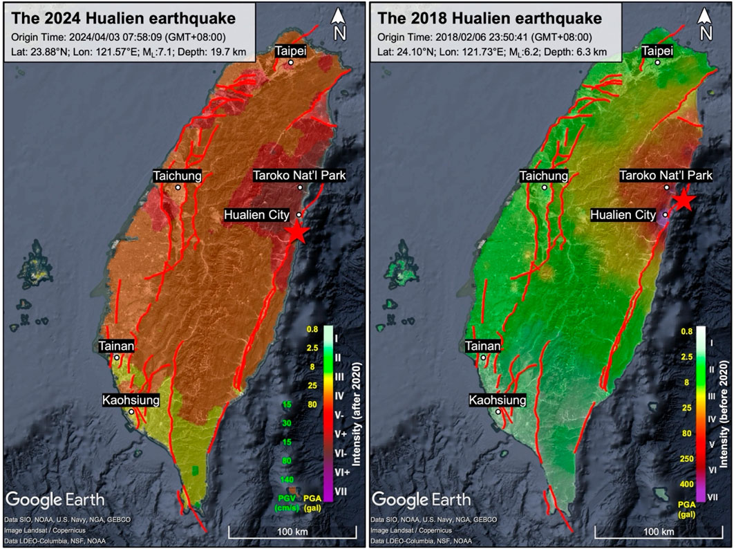
Figure 1. Seismic intensity map of the 2024 and 2018 Hualien earthquakes. “Note that Taiwan’s seismic intensity scale was updated in 2020, resulting in different scales being used for the two earthquakes. Before 2020, the intensity relied solely on PGA, but after 2020, it incorporates PGV when PGA exceeds 80 gal (see Section 4 for a detailed discussion). Intensity data: CWA (Central Weather Administration, 2025a; Central Weather Administration, 2025b), Fault lines: TEM (Shyu et al., 2020). Map data: Google.
Table 1. Earthquake information of the 2024 and 2018 Hualien earthquakes.
2.4 Comparison of the 2024 and 2018 Hualien earthquakes
The 2018 Mw 6.4 Hualien earthquake, although the magnitude being notably smaller than the 2024 earthquake, caused significant damage and casualties in Hualien City. The hypocenter depth of the 2018 Hualien earthquake was only 6.3 km, located 16.5 km NE of Hualien City (Table 1). Therefore, the difference in hypocenter depths between the two earthquakes may account for the comparable damage caused by the 2018 and 2024 earthquakes. In addition, the 2018 earthquake was accompanied by a shallow fault rupture along a known active fault, the Milun Fault, running through Hualien City (Kuo et al., 2019a; Lee et al., 2019). A fault rupture on the Milun Fault generated a localized PGA greater than 400 cm/s2 (seismic intensity of 7 at that time) in Hualien City (Figure 1), damaging buildings that were roughly distributed along the fault. Therefore, although the 2018 earthquake had a lower magnitude than the 2024 earthquake, the rupture of the Milun Fault during the mainshock likely amplified the damage in Hualien City. In contrast, the 2024 earthquake occurred at a greater depth and did not cause surface ruptures, producing a broadly distributed, high-intensity signal throughout northern and central Taiwan (Figure 1). These observations suggest that the magnitude, hypocenter depth, and rupture characteristics play equally important roles in shaping the extent of damage in affected areas. We will discuss the update to the seismic intensity scale in 2020 in Section 4.
3 Damage and emergency responses of the 2024 Hualien earthquake
The 2024 Hualien earthquake was the strongest to strike Taiwan since the 1999 Chi-Chi earthquake. It resulted in 18 deaths, 1,155 injuries, and three missing persons (two Singaporean nationals and one German national), with significant impacts in various regions. Within 10 min of the earthquake, the CWA issued an earthquake report detailing the intensity throughout Taiwan (Figure 1). The highest intensity, measured at 6+, was recorded in the northern part of Hualien County, while Hualien City experienced an intensity of 6-. In addition, a wide area across the island, including Taipei, experienced intensities ranging from 4 to 5+. Given the relatively greater damage in Hualien, Taipei and New Taipei, this section will focus on the situations caused by the earthquake and emergency responses in these areas.
3.1 Hualien area
3.1.1 Timeline of emergency response
As the epicenter of the earthquake, Hualien was the hardest hit region. The damage was concentrated in the urban areas of Hualien City and mountainous regions near Taroko National Park. The earthquake caused severe fractures and subsidence at Hualien Port, the collapse of multiple buildings in the city (e.g., Figure 2), and significant structural damage to the campus of Hualien Girls’ Senior High School. A fire broke out in the chemistry laboratory of National Dong Hwa University due to the earthquake.
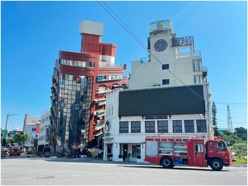
Figure 2. The tilted Uranus Building in Hualien City (National Dong Hwa University, 2025).
In terms of transportation, the Su-Hua Coastal Road, which connects Hualien to Yilan, experienced multiple landslides, rockfalls, and bridge collapses, temporarily isolating Hualien and rendering it an “island”. In Taroko National Park, numerous trails and roads were damaged by landslides and falling rocks, and several tourists went missing.
The timeline of the actions made by the government is summarized in Table 2.
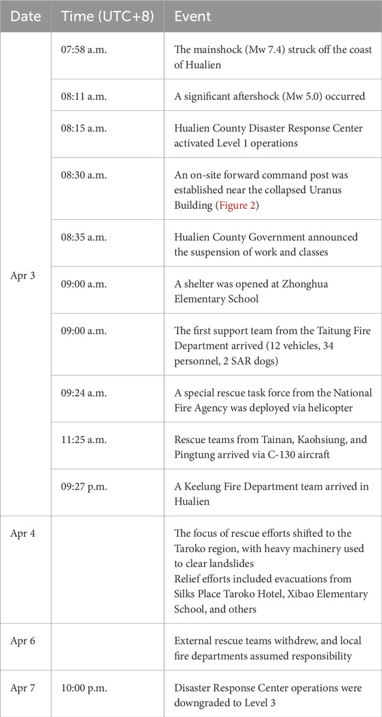
Table 2. Summary of Disaster Reports Following the 2024 Hualien earthquake.
3.1.2 Disaster report analysis
According to data from the Emergency Management Information Cloud operated by the National Fire Agency, 611 disaster reports were logged during the five-day operation period, as shown in Table 3 and Figure 3. Hualien’s population of approximately 310,000, with one-third residing in Hualien City, suggests that actual disaster figures may be higher owing to communication breakdowns and a sparse population in mountainous areas. Nevertheless, the data provided a general overview of the impact of earthquakes.
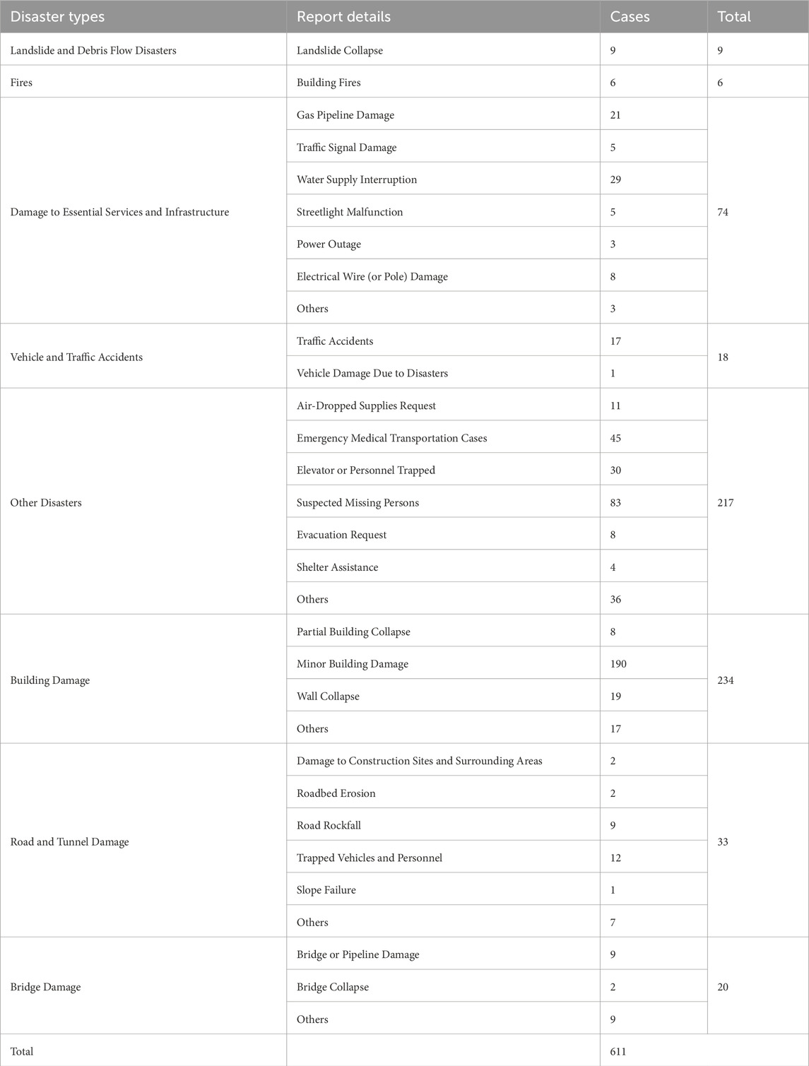
Table 3. Summary of disaster reports following the 2024 hualien earthquake.
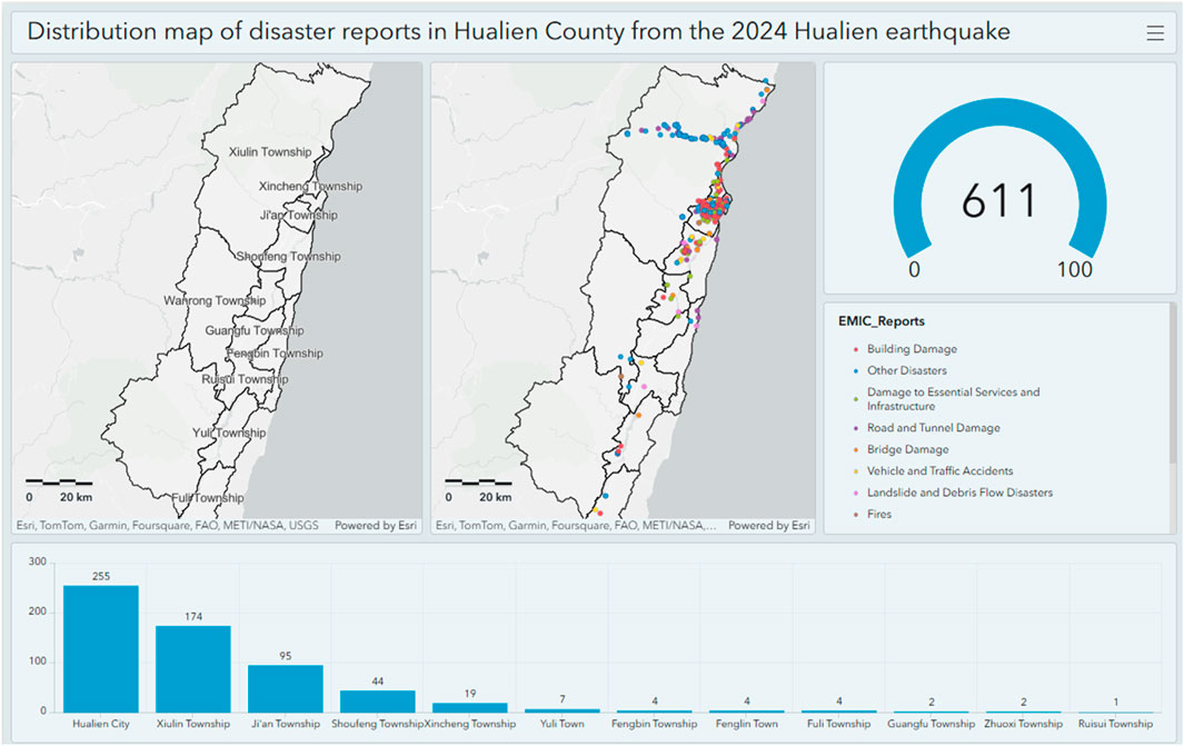
Figure 3. Distribution map of 611 disaster reports in Hualien County from the 2024 Hualien earthquake (statistics from April 3 to April 7, exported from the Emergency Management Information Cloud system) (Distribution map of disaster reports, 2025).
The majority of reports fell into two categories: building damage (234 cases) and “other” incidents (217 cases). Building damage primarily involved structural collapses and severe damage, while “other” incidents included reports of trapped individuals, missing persons, medical emergencies, and requests for evacuation and shelter. Reports related to infrastructure damage (74 cases) included power outages, water-supply disruptions, damaged traffic signals, and ruptured gas pipelines. Transportation-related damage included 33 cases involving roads and tunnels, and 20 cases involving bridges, with significant disruptions in mountainous areas such as Xiulin Township and Taroko National Park.
Notably, the earthquake triggered several fire incidents, most of which occurred within the first hour of the event. The first reported case was a chemical fire in the National Dong Hwa University laboratory caused by a chemical spill from the earthquake.
Geographically, most disaster reports (over 350 cases) were concentrated in urban areas, including Hualien City and Ji’an Township. Xiulin Township, characterized by mountainous terrain and access challenges, accounted for 174 cases. The other townships recorded fewer incidents. This distribution highlights the differences in disaster impact between urban and rural areas.
3.2 Taipei city area
To enhance the earthquake response capabilities of local governments, the CWA implemented a rapid earthquake reporting system at the administrative district level. This system delivers automated seismic-monitoring network data within 3 minutes of an earthquake, bypassing human verification. The results were disseminated to all schools nationwide and to counties, cities, and township-level disaster-response centers. These reports serve as critical references for emergency operations by disaster prevention organizations, as illustrated in Figure 4.
Figure 4. The earthquake rapid reporting system for each administrative district of Taipei City for the Hualien earthquake on 3 April 2024 (Taipei City Disaster Prevention and Rescue Office, 2024).
3.2.1 Response escalation timeline
At 8:01 a.m., the Taipei City Disaster Response Center was upgraded to Enhanced Level 3 activation in accordance with standard operating procedures after the earthquake rapid reporting system indicated an intensity level of four or higher (Figure 4). At 8:13 a.m., based on the formal earthquake report from the CWA, which confirmed an intensity level of 5 in Taipei City, the center was further elevated to level 2 activation. At 8:39 a.m., anticipating multiple disaster incidents in Taipei City, the commander directed the center to escalate to Level 1 activation. A working meeting was held at 8:50 a.m.
During the operational period, the center recorded 1,151 disaster reports (Figure 5). Of these, 499 incidents involved minor structural damage to buildings, while 397 pertained to disruptions in essential infrastructure such as damaged gas pipelines, water leaks, and power outages. Most incidents were resolved by noon on April 5, after which the center resumed its regular level 3 activation status and maintained a monitoring posture.
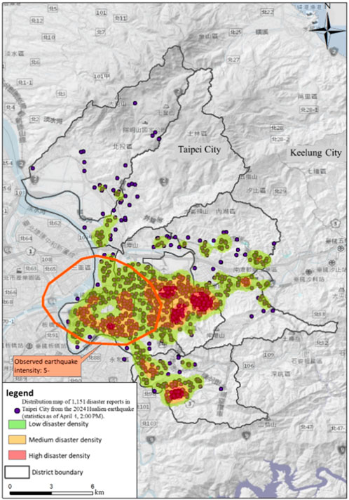
Figure 5. Distribution map of 1,151 disaster reports in Taipei City from the 2024 Hualien earthquake (statistics as of April 4, 2:00 p.m.).
3.2.2 Structural damage assessment and evacuation
Structural damage induced by earthquakes requires a comprehensive evaluation by professional engineers. The Building Administration Office of the Taipei City Department of Urban Development managed the assessments in accordance with the “Emergency Assessment Principles for Hazardous Buildings Post-disaster”.
A severely damaged building in Lane 307, Section 2, Zhonghua Road, Zhongzheng District, identified as a red-tag-restricted area, requires immediate action. The Taipei City Fire Department established an onsite forward command post at 3:09 p.m. on April 3. Resident evacuation was initiated at 9:30 p.m., resulting in the evacuation of 61 individuals.
Subsequent management was undertaken by the Zhongzheng District Office. From April 4 to April 6, structural inspections were conducted by three professional engineering associations, along with the installation of temporary safety supports. By 8:30 p.m. on April 6, some buildings were reclassified as yellow-tagged areas, allowing residents to return. The forward command post was decommissioned by 9:00 p.m. under the directive of the Zhongzheng District Director.
The more details of these responses are chronologically summarized as follows:
• Immediate Hazard Evaluation: On April 3, at 2:00 p.m., engineers from the three major professional associations assessed the structural damage at Lane 307, Section 2, Zhonghua Road, and determined that beam and column damage posed immediate risks. A red-tag restriction notice was issued, initiating a precautionary evacuation for nearby residents.
• Forward Command Post Operations: At 3:09 p.m. on April 3, the Taipei City Fire Department established a forward command post with personnel from the Public Works Department, Building Administration Office, Social Affairs Bureau, Police Department, and Tourism and Information Department. Four Tzu Chi volunteers provided logistic support for this study. By 9:30 p.m., 61 residents were evacuated.
• Structural Assessments: On April 4 at 10:50 a.m., joint inspections by professional engineers confirmed the need for H-beam support. At 12:40, the inspection results identified buckling in the four columns, necessitating immediate reinforcement with temporary supports.
• Reinspection and Expansive Assessments: On April 6 at 8:45 a.m., even-numbered buildings on Lane 307 underwent structural reinspection supervised by officials from the Department of Urban Development. Additional inspections in lane 309 identified three buildings that required five H-beam supports for temporary safety.
• Reclassification and Post Withdrawal: By 8:30 p.m. on April 6, buildings on lanes 307 and 309 were reclassified as yellow-tagged areas, and residents were allowed to return. The forward command post was officially withdrawn at 9:00 p.m.
• Resident Accommodation and Return: Evacuation records revised on April 6 indicated that 63 residents were displaced, with 34 accommodated in hotels and 29 staying with relatives. Residents in temporary accommodations were advised to check at 11:00 a.m. on April 7, with transportation arranged by the district office.
• Completion of Operations: As of April 7, all displaced residents returned home, concluding with temporary accommodation arrangements.
3.3 New Taipei City area
3.3.1 Response escalation timeline
New Taipei City was struck by ground shaking with a seismic intensity of 5-. In accordance with standard operating procedures, the New Taipei City government (New Taipei City Government, 2024) activated its disaster response mechanisms at Level 1 at 8:47 a.m. Core departments, including the Fire Department, Water Resources Department, Public Works Department, and Transportation Department, were fully mobilized.
The major disaster in New Taipei City can be divided into structural damage and damage to the subway system, as shown in Figure 6. Further details can be found in Sections 3.3.2 and 3.3.3.
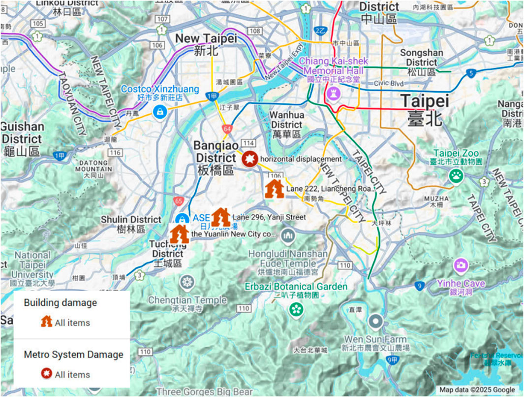
Figure 6. The major disaster of New Taipei City induced by the 2024 Hualien earthquake.
3.3.2 Structural damage assessment and evacuation
Structural damage in New Taipei City was assessed by the New Taipei City Public Works Department (New Taipei City Public Works Department, 2025) and local professional associations, with guidance from “Emergency Post-Disaster Building Assessment Procedures”.
The emergency assessment revealed some critical damage at several locations:
• In Zhonghe District, at Lane 222 on Liancheng Road, a 34-year-old, 4-story building sustained severe damage to its shear walls and stairwell columns, although 12 households were safely evacuated.
• In Tucheng District, Lane 296, Yanji Street, a 41-year-old, 5-story building was identified as structurally unsafe. A total of 40 households were evacuated following the issuance of red-tag safety notices.
• At the Yuanlin New City community (Building C) in Zhonghe District, severe damage to basement columns and beams required immediate emergency shoring and the evacuation of 48 households.
The sequential response timeline for structural damage assessment is as follows:
• Immediate Hazard Evaluation: On April 3, structural engineers conducted rapid assessments of affected buildings, issuing red or yellow-tag notices as needed.
• Resident Evacuation: Evacuations began on the afternoon of April 3, coordinated by the Fire Department and local district offices.
• Shelter Operations: By April 7, 18 shelters had been opened across the city to accommodate displaced residents.
• Temporary Support Installations: Emergency structural reinforcements, including H-beam installations, were completed for high-risk buildings between April 3 and April 6.
• Return and Recovery: Reassessment processes facilitated the gradual reclassification of some structures from red-to yellow-tagged status, allowing for the phased return of residents.
Additionally, the New Taipei City government launched a building repair subsidy program to assist residential communities (excluding severely damaged structures) in restoring common areas (Chinese Society of Structural Engineering, 2025; The Control Yuan of R.O.C Taiwan, 2025; New Taipei City Department of Rapid Transit Systems, 2025).
3.3.3 Damage and recovery operations of the metro system
The earthquake caused significant damage to the New Taipei Metro Circular Line and light rail systems. The New Taipei City Department of Rapid Transit Systems oversaw necessary measures to ensure public safety and minimize transportation disruption. The observed damage and the actions taken are summarized as follows:
• Structural Impacts: The elevated section 1215-1 on Zhongzheng Road (Zhonghe District) experienced horizontal displacement, while a train derailment at Jingan Station damaged track slabs and station platform doors, as shown in Figure 7.
• Immediate Operational Suspension: All services were suspended immediately after the earthquake to allow for inspections and emergency response operations.
• Restoration Timeline on April 3:
○ 9:36 a.m.: Partial resumption of Ankeng light rail service.
○ 4:30 p.m.: Full resumption of light rail service.
○ 5:00 p.m.: Partial reopening of the Circular Line between Banqiao Station and Industrial Park Station, operating with two-way single-track service.
• Shuttle Services: Free shuttle buses were deployed between New Taipei Industrial Park and Dapinglin stations as an alternative to suspended services.
• Infrastructure Repairs and Reinspection: Phase inspections, repairs, and dynamic system tests were conducted from April 3 to April 7.
• Service Recovery: By April 7, two-way service was resumed between Zhonghe Station and Dapinglin Station, restoring approximately 70% of the Circular Line’s total capacity.
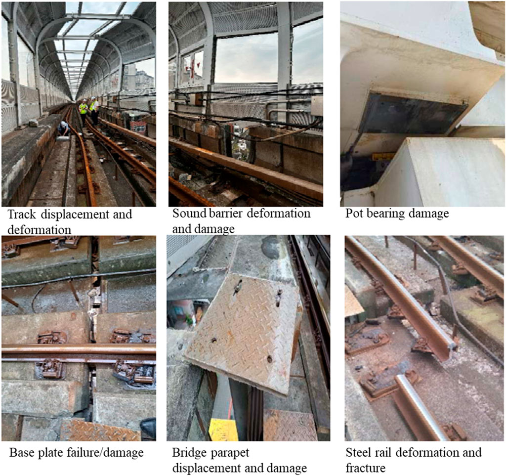
Figure 7. New Taipei Circular Line Earthquake Bridge Damage Status of the earthquake on 3 April 2024. (Chinese Society of Structural Engineering, 2025)
4 Earthquake resistant measures in Taiwan and observed features
4.1 Seismic intensity scale in Taiwan
The current seismic intensity scale used in Taiwan is summarized in Table 4, along with the scale used from 2000 to 2020. The Central Weather Bureau (CWB), the original body of the current CWA, changed the seismic intensity scale in 2020 to increase its correlation with the severity of structural damage observed in past earthquakes. The details are found from a CWA’s notification (Central Weather Administration, 2025e), and the major updates are as follows:
• The new intensity scale has five degrees over an intensity of 5:5-, 5+, 6-, 6+, and 7.
• Scales over intensity 5 were determined by the peak ground velocity (PGV) rather than the peak ground acceleration (PGA).
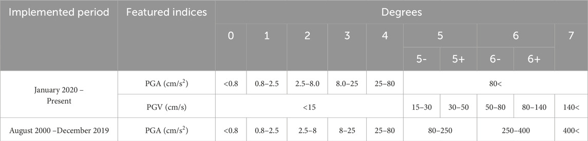
Table 4. Seismic intensity scales in Taiwan.
In past earthquakes, it has been observed that structural damage is more closely linked to the PGV than to the PGA e.g., (Wu et al., 2002). This finding was directly reflected in the new seismic intensity scale.
4.1.1 Japanese seismic intensity
The original seismic intensity scale in Taiwan was influenced by the Japan Meteorological Agency (JMA) intensity scale, which also has ten degrees, ranging from 0 to 7, with additional gradations of 5-, 5+, 6-, and 6+. The intensity at a site during an earthquake is determined by the ground acceleration recorded by a seismometer approved by the JMA. This scale has been in use since April 1996, reflecting lessons learned from the 1995 Hyōgo-ken Nanbu (Kobe) earthquake. Prior to its introduction, seismic intensity was determined based on human perception of ground shaking.
The JMA seismic intensity scale is primarily based on both PGV and PGA, as it also considers the duration of ground acceleration. The procedure focuses on the frequency components near 0.5 Hz, which significantly influence structural damage and human perception of earthquakes. Further details can be found in the literature (Karim and Yamazaki, 2002). This intensity scale has been in use for 29 years, though discrepancies between intensity levels and structural damage have occasionally been observed in major past earthquakes, particularly at the 6+ and 7 levels. As a result, several alternative seismic intensity scales (Japan Meteorological Agency, 2025d) have been proposed, although they are primarily used in research.
Since February 2023, a new intensity scale for long-period ground motions has been implemented to address the needs of long-period structures, such as high-rise buildings. The scale has four degrees, based on the maximum value of the absolute velocity response spectrum (Sva) with a 5% damping ratio, focusing on the range of 1.6–7.8 s (Japan Meteorological Agency, 2025b).
4.1.2 Seismic intensities in the Hualien earthquakes in 2024 and 2018
Recently, Hualien was affected by several large earthquakes. The Hualien earthquakes in 2018 and 2024 were predominant with respect to the impact and severity of ground shaking. Therefore, these two earthquakes were compared to study their differences. Based on the intensity scales provided by the CWA/CWB for earthquakes, the number of sites exceeding a seismic intensity of 5 is listed in Table 5.
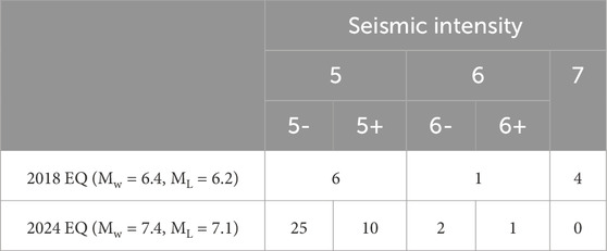
Table 5. Number of sites recording the ground shaking over seismic intensity 5 at the 2018 and 2024 Hualien earthquakes.
According to Table 5 and Figure 1, the 2018 earthquake was characterized by extremely strong ground shaking, including a seismic intensity scale of 7 in a localized area, resulting in a concentration of severe damage in towns near the sites. In contrast, the severity of the 2024 earthquake was limited to 6+ and was recorded at only one site. The 2024 earthquake was characterized by strong, but not extremely strong, ground shaking over a wide area (Figure 1), resulting in moderate damage in a broad region and moderate damage to cities.
Although a comparison based on seismic intensity is useful for a rough understanding of the two earthquakes, it is not accurate because of the change in the seismic intensity scale in 2020. To be fairer, the ground shaking of the earthquakes was compared based on the PGA and PGV (Figure 8). The data for the 2024 earthquake were directly provided by the CWA, while the 2018 data were analyzed by the research team (Kuo et al., 2019b).
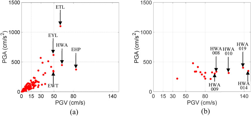
Figure 8. PGV and PGA of the Hualien earthquakes (a) 2024 and (b) 2018. (The names of the top five PGV stations are listed.)
According to Figure 8b, several sites recorded very strong shaking, much larger than PGV = 80 cm/s, in the 2018 earthquake, whereas it did not occur in the 2024 earthquake (Figure 8a), even though the latter had a much larger magnitude than the former. Additionally, the 2018 earthquake induced extremely large PGVs (≥80 cm/s) with moderate PGAs, indicating the dominance of low-frequency components. In contrast, the 2024 earthquake generated large PGVs (50–80 cm/s) along with large PGAs, indicating the dominance of high-frequency components. Because PGV is more influential on structural damage, this also supports the above finding: the 2018 earthquake caused extremely severe situations for buildings in a localized area, whereas the 2024 earthquake caused difficult situations for many buildings in a broad region.
The different ground shaking characteristics during these earthquakes are mainly attributed to the locations of the causative faults and rupture mechanisms. The 2018 earthquake occurred immediately below Hualien City, where some buildings were severely damaged or collapsed. The directivity of fault ruptures has also been identified as a cause of severe damage (Kuo et al., 2019b). The earthquake in 2024 did not induce the directivity effect significantly.
4.2 Soil conditions in the Hualien and other areas
In general, ground shaking is affected by the site conditions at which it occurs along with the characteristics of the earthquakes themselves. This condition is commonly classified as Vs30, which is the average shear-wave velocity of the soil or rock from the ground surface to a depth of 30 m. According to the provisions of the National Earthquake Hazards Reduction Program (NEHRP) (National Earthquake Hazards Reduction Program NEHRP, 2020), the Vs30 values for different materials are summarized in Table 6.
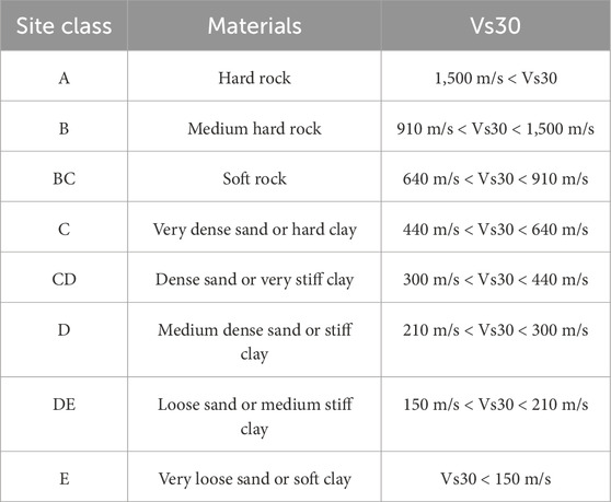
Table 6. NEHRP’s classification on site conditions.
According to a study on Vs30 of the stations of the Taiwan Strong Motion Instrumentation Program (TSMIP) (Liu and Tsai, 2015), the site conditions in Hualien were clarified by comparison with other areas. Based on this study, the Vs30 in the seven areal categorizations of Taiwan are shown in Figure 9, and the number of stations and median values in the areas are summarized in Table 7.
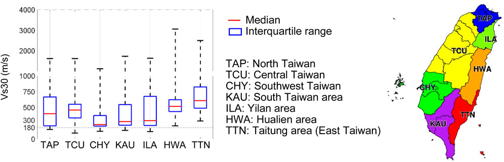
Figure 9. Vs30 in the seven major areas of Taiwan.

Table 7. Number of TSMIP stations in the seven areas and the median of Vs30s in each area.
The median value for the Hualien area (HWA) of 521 m/s was the second best among the seven areas. In addition, according to the interquartile range, the Vs30 values at many sites in Hualien were close to the median value. Thus, many sites in Hualien were less likely to experience amplified ground shaking than in other areas. Strong shaking with large PGVs occurs mainly because of earthquake features or a limited number of soft site conditions. Unfortunately, this occurred during the 2018 Hualien earthquake and resulted in large PGVs (Figure 8b).
4.3 Earthquake early warning systems
4.3.1 EEW systems in Taiwan and their contributions
Taiwan is actively developing early earthquake warning (EEW) systems. Its effectiveness in disaster mitigation and relief, such as providing lead time for immediate evacuation and shake maps shortly after an earthquake, was demonstrated during recent major events (Wu et al., 2021), including the 2018 Hualien earthquake (Mittal et al., 2021). During the 2024 Hualien earthquake, warnings were issued by the CWA within 20 s (National Center for Research on Earthquake Engineering, 2024) of occurrence, according to a quick report from the National Center for Research on Earthquake Engineering (NCREE). The warnings were reported to have saved some evacuees in Hualien, such as visitors to Taroko National Park (Petley, 2024a). In addition, based on the warnings, the Taiwanese government swiftly activated emergency operations to immediately dispatch rescuers and build shelters (National Center for Research on Earthquake Engineering, 2024).
Three major EEW networks exist in Taiwan, as summarized in Table 8. The CWA uses a strong motion network (Central Weather Administration, 2025d), which is established as part of the TSMIP, for the system. The NCREE has an EEW system (Hsu et al., 2021), and National Taiwan University (NTU) operates a P-alert network (Mittal et al., 2022).
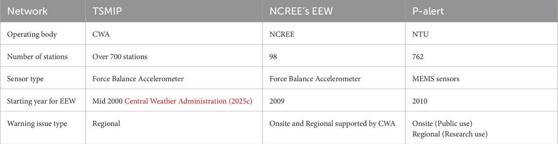
Table 8. Three Major EEW networks in Taiwan.
The TSMIP network used by the CWA has over 700 free-field strong-motion stations, which have been gradually added since 1991. Each station has a set of servo accelerometers placed under free-field conditions. Their use for EEW began in the mid-2000s based on a regional approach. In this approach, ground motion data collected near the epicenter are transferred in near real-time to the main operating system, which estimates the intensity and arrival time of major shaking. An early warning is issued when the estimates exceed the predefined thresholds. The issuing speed depends on the distance between the measurement site and the epicenter, as well as the speed of communication and data processing. The CWA delivers warnings in Taiwan within approximately 20 s as text messages to mobile phones and TV, as well as direct broadcasting to schools.
The NCREE originally established an EEW system in 2009, primarily for several elementary schools. Currently, this system has 98 seismic stations and 3,514 broadcast stations, cover all schools in Taiwan, approximately 3,500 schools. Each seismic station had a set of equipment consisting of seismometers, a data logger, a computer, and an alert broadcast system. Seismic stations issue warnings based on an on-site approach and send them to broadcast stations that have the function of alert broadcasting only. In addition to the onsite alerts issued by the three nearby seismic stations, each broadcast station receives regional alerts from the CWA and broadcasts the alert whichever arrives faster.
The P-Alert network was established by NTU specifically for EEW. To fulfill its specific role cost-effectively, the network uses a set of micro electro mechanical systems (MEMS) sensors for each station, allowing it to have 762 stations. Many sensors are placed on the walls of 1F or 2F in elementary schools (Mittal et al., 2022), which can support the power supply and network communication. Because CWA is the only agency authorized to issue earthquake warnings using a regional approach, the P-Alert network is based on an onsite approach for public use. In this approach, the sensor unit at each station can issue an alarm based on the internal processing of the ground motion record. As the P-alert network has a main operating system consolidating the data recorded by each sensor unit, it can work as a regional approach, but its use is limited for research.
These networks, with more than 1,500 stations, complement each other in monitoring strong shaking throughout Taiwan and issuing warnings when large earthquakes occur. The collected data are also used to immediately produce shaking maps of the PGA and PGV, which are immediately sent to various media to prompt emergency rescue and decision-making.
4.3.2 Japanese EEW system
Japan also has an EEW system that began operations in 2007. It is currently based on 690 seismometers operated by JMA and approximately 1,000 stations operated by the National Research Institute for Earth Science and Disaster Resilience (Japan Meteorological Agency, 2025c). Its technical details are found from the literature (Kodera et al., 2021).
The development of the EEW system in Japan, which began in the late 1980s (Nakamura, 1988), was initially focused on the Japanese railway system. In 1992, the Railway Technical Research Institute fully implemented the UrEDAS (Urgent Earthquake Detection and Alarm System) for the Tokaido Shinkansen railway system (Yamamoto and Tomori, 2013). At this early stage, the system’s purpose was limited to ensuring the safety of high-speed railways, rather than providing warnings to the public.
In response to the 1995 Hyōgo-ken Nanbu (Kobe) earthquake, the Japanese government decided in 1996 to develop the High Sensitivity Seismograph Network Japan (Hi-net), which later became a key component of the Japanese EEW system (Kodera et al., 2021). The JMA began trial operations of the EEW system in February 2004, targeting government agencies, transportation companies, media organizations, and others (Japan Meteorological Agency, 2025a). The coverage gradually expanded to almost the entire country by 2005, and EEW services for the public officially began in October 2007.
The Japan Broadcasting Corporation (NHK) is legally required to immediately broadcast warnings issued by the JMA to the public (Ministry of Land, Infrastructure, Transport and Tourism, 2013), though these warnings can also be delivered through other communication channels such as radio, mobile phones, and more. Additionally, advanced technical users can receive forecasted information more quickly via dedicated lines, enabling faster responses to impending ground shaking.
The effectiveness of the current EEW system, which has been greatly updated since the 2011 GEJE, has been demonstrated in the 2016 Kumamoto earthquake (Kodera et al., 2016) and 2024 Noto Peninsula earthquake (Yamada et al., 2025).
4.4 Building code in Taiwan and the damage caused by the earthquakes
4.4.1 Building code
The seismic force requirements (SFR) for building structures in Taiwan were implemented in 1974, based on the US Uniform Building Code (UBC). In 1997, the SFR incorporated the response spectrum method (Chai et al., 2009). The latest update of the building code was published in October 2022, revising provisions regarding the near-fault effect to further enhance the safety of buildings in near-fault zones and introducing regulations to prevent building collapses owing to weak first stories were added. The UBC was succeeded by the International Building Code (IBC), in which the seismic code provisions are based on those of the American Society of Civil Engineering, commonly known as ASCE 7. Taiwan’s current seismic design loads follow ASCE 7 principles.
As demonstrated by the damage to soft and weak first-story buildings in the 2024 Hualien earthquake, seismic damage cannot be solely discussed in terms of design seismic response spectra; it is also influenced by other detailed provisions in seismic codes. Additionally, the latest design response spectrum may differ from the one used when the damaged buildings were constructed. Nonetheless, the design response spectrum remains one of the most important factors in assessing seismic resilience, as it determines the magnitude of the seismic forces acting on a building.
The Vs30 of the surface soil in Hualien is 520.6 m/s, as described in Section 4.2, which is close to 520 m/s, where the Site Class coefficients,
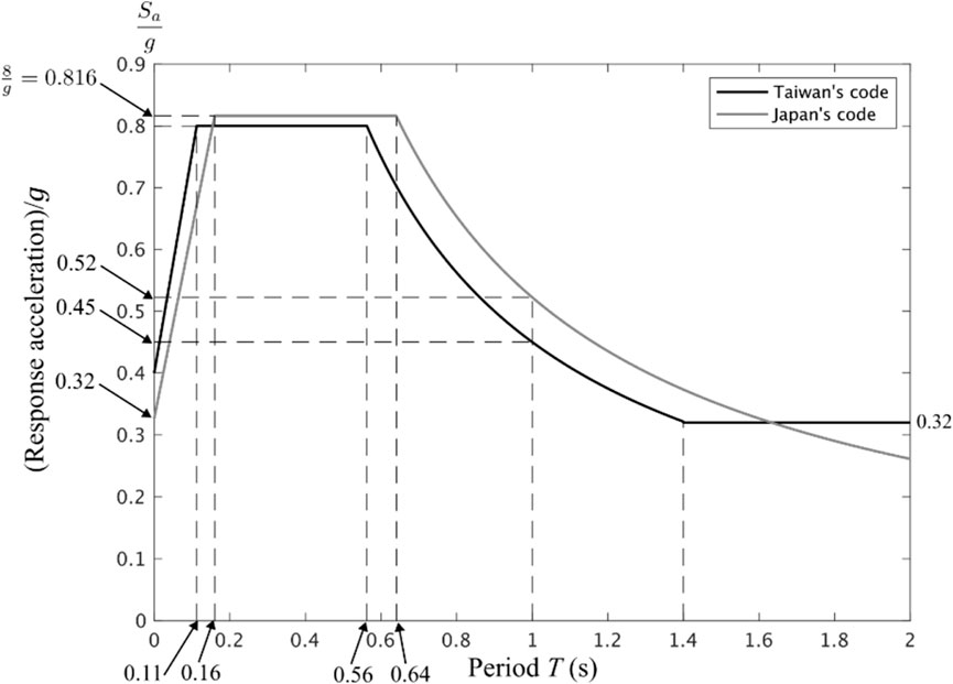
Figure 10. Design spectra (damping ratio: 5%).
The spectra were normalized to acceleration due to gravity (g = 9.8 m/s2). From an international perspective, Taiwan’s seismic code provisions are highly sophisticated, contributing significantly to seismic resilience.
4.4.2 Seismic vulnerability of soft and weak first story buildings
In commercial buildings and residential complexes, there are often fewer seismic-resistant walls on the first floor than on the upper floors, which can result in a soft and weak first story. During the 2016 Southern Taiwan (Meinong) earthquake, the lower floors of the Weiguan Jinlong residential complex and King’s Town Bank, both of which had soft and weak stories, collapsed. During the 2018 Hualien earthquake, the Marshal Hotel and Yun Men Tsui Ti Building (Figure 11), which also had soft and weak stories, suffered similar damage. Taiwan’s latest seismic code now includes regulations for soft- and weak-story buildings, allowing for phased reinforcement of existing structures to prevent damage until full reinforcement is completed. In Japan, similar damage occurred during the 1995 Hyōgo-ken Nanbu (Kobe) earthquake, prompting stricter regulations for soft- and weak-story buildings in the 2000 revision of the Building Standards Law.
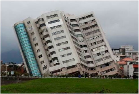
Figure 11. Severely tilted soft and weak story building (Yun Men Tsui Ti Building) in the 2018 Hualien earthquake.
The Uranus Building, which tilted significantly during the 2024 Hualien earthquake, was also a soft and weak-story building and did not meet the current design code described in Section 4.4.1. As observed in this case, similar damage continues to occur because seismic retrofitting and the enforcement of stricter seismic code provisions have not kept pace. Therefore, it can be said that the urgent implementation of a more effective seismic code is critical.
5 Disaster management in Taiwan
5.1 Disaster management system in Taiwan
Taiwan’s disaster risk-management system progressed rapidly after the 1999 Chi-Chi earthquake. After the earthquake, the Disaster Prevention and Response Act (DPRA) was enacted as the first basic disaster-related law. According to the DPRA, the disaster management system consists of several government levels: Central, Municipality/County, and Township, as shown in Figure 12. Each level of government is required to establish a Disaster Prevention and Response Council (DPRC), which is responsible for making and implementing relevant disaster management policies and plans. Under the DPRA, not only government officials but also the armed forces, military corps, NGOs, and community organizations are included in the comprehensive emergency management network. In this framework, each level of government is tasked with developing its own local disaster management plans. However, many local governments have been unable to develop comprehensive plans due to a lack of human and financial resources. Therefore, when a devastating disaster occurs, these local governments still rely on support and resources from the central government. At the same time, the local government immediately activates the Emergency Operations Center (EOC) as the command center during emergencies and takes the lead in rescue efforts, among other actions. (Tso et al., 2011).
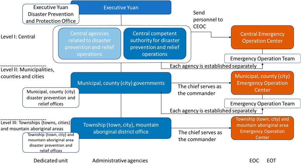
Figure 12. The disaster management system of the Taiwan government.
After Typhoon Morakot in 2009, the Office of Disaster Management (ODM) was established to oversee and implement emergency management-related policies and ensure efficient policy implementation. They are also responsible for coordinating relevant disaster management agencies (Chuang and Ho, 2021). Taiwan’s disaster management system is divided into three levels: central government, country or city, and township.
The IRIDeS group visited the Hualien Fire Department Office on 6 August 2024, to learn about the local government’s disaster response efforts. The unique aspect of the coordination mechanism at the local level was that, in addition to the local government agencies deeply involved in relief efforts, academia and NGOs were also part of it, and each stakeholder understood its role. Academia provides information collected using the latest science and technology, while NGOs regularly offer relief assistance and training programs to government officials. They participated in regular coordination meetings to exchange information, and a network and partnership was established among these stakeholders before the disaster occurred. In an emergency, it is common for stakeholders involved in relief activities to meet each other for the first time, and it takes time to understand each other’s roles, capabilities, and methods of working together. To enable prompt and effective relief activities, it is crucial to establish a network and coordination mechanism that regularly includes various stakeholders, as is practiced in Taiwan. This approach has broadened collaboration beyond government agencies to include academia and NGOs.
5.2 NGOs in Taiwan and the role and activities in disaster response and recovery
NGOs play an essential role in assisting governments during disasters, especially in the recovery process, as they can operate at the grassroots level with high operational flexibility and address the needs of the most vulnerable groups (Tsai et al., 2022). The government cooperated with large-scale NGOs in Taiwan to facilitate post-disaster reconstruction programs after Typhoon Morakot. Construction after the typhoon was outsourced to large-scale NGOs, such as the Buddhist Compassion Relief Tzu Chi Foundation (Tzu Chi), with the local government’s support to save money and time, as these NGOs received huge public donations (Tsai et al., 2021).
The Mustard Seed Mission (MSM), the oldest social service organization in Taiwan, collaborated with bus and truck companies to send supplies from western Tainan to eastern Taitung. Meanwhile, the Tzu Chi Foundation, headquartered in Hualien, activated its disaster relief response team within 45 min and implemented emergency response protocols at the Hualien Tzu Chi Hospital, providing blankets and financial aid to survivors and smaller organizations. Within the hour, the Chinese Christian Relief Association (CCRA) rushed to the most affected areas and established evacuation centers in a school, a park, and a gymnasium. Each organization leveraged its unique strengths and allocated tasks efficiently. The CCRA, with experience running a food bank, collected and distributed water and food, setting up its mobile kitchen to prepare additional meals for victims. World Vision collaborated with the Taiwan Fund for Children and Families (TFCF), another smaller NGO on the island, to establish children’s care centers. These actions highlight the organizations’ swift response times and their commitment to understanding their strengths and working together to respond effectively during disasters. Peace Winds Japan sent an emergency support team, including nurses, coordinators, and other personnel, to Hualien to assess support needs and distribute essential supplies (CFE-DM and University of Maryland School of Public Policy, 2024).
The Tzu Chi Foundation is one of Taiwan’s largest NGOs, and plays an active role in many of the country’s disaster response and recovery efforts. It was founded in 1966 by a Taiwanese Buddhist group. With more than 80,000 volunteers, Tzu Chi has mainly focused on humanitarian activities, such as education, humanities, and disaster reconstruction (Tsai et al., 2021).
In the case of the Hualien earthquake, as with other disasters, Tzu Chi collaborated with various organizations and agencies to deliver prompt emergency assistance to those in affected areas. Tzu Chi volunteers quickly distributed relief supplies, including eco-blankets, temporary beds, partitions for shelters, tents, drinking water, energy drinks, hot meals, and emergency financial assistance. Additionally, Tzu Chi established operations at the Hualien County Government Disaster Response Center, making it the only civilian organization to do so. Tzu Chi worked alongside the authorities and other NGOs to provide comprehensive support to affected residents and assist in frontline rescue efforts (Lewis, 2024).
After the 2018 Hualien earthquake, the Tzu Chi Foundation and the Hualien County government signed a memorandum of cooperation to strengthen disaster preparedness and relief capabilities. Similar agreements were established with Hualien and the townships of Xincheng, Xiulin, and Ji’an. As a result, many officials attended evacuation and shelter training courses organized by Tzu-Hao (2024). During the 2024 earthquake, Tzu Chi provided shelter spaces equipped with privacy booths, folding beds, and blankets to ensure the comfort and privacy of displaced residents at Huaren Junior High School. The disaster response and shelter exercises conducted by Tzu Chi and the Ji’an Township Office prior to the disaster enabled prompt and effective assistance. To minimize the impact of disasters, it is crucial to conduct regular drills and training during normal times (Tzu-Hao, 2024).
5.3 Characteristics of the NGO in Taiwan
The IRIDeS group visited the Tzu Chi headquarters in Hualien on 6 August 2024, to meet the staff who play a crucial role in disaster relief and recovery and learn about the organization and its activities. From the interviews, four key characteristics of Tzu Chi were identified that distinguished it from the other NGOs.
1) They support startups in industries or are directly involved in their operations to self-source the technology and goods required for disaster response and recovery. When performing reconstruction work to provide new houses to affected people, engineers can be provided within their own organizations. Tzu Chi created a system that allowed him to be self-sufficient in most of its work.
2) To provide prompt assistance during a disaster, they coordinated with the Taiwanese government in advance and agreed on the division of responsibilities. For instance, when building reconstructed housing, the government provides the land free of charge, whereas Tzu Chi constructs buildings at its own expense.
3) Tzu Chi had a large number of high-quality volunteers. They provided two-year training courses to the volunteers, and without finishing these courses, they were not allowed to work as volunteers. This ensured that Tzu Chi maintained high-quality volunteers, leading to a high standard of assistance.
4) Tzu Chi placed particular emphasis on the quality of its relief work. For example, only warm meals were served and tents were provided to shelters to ensure privacy.
These four characteristics worked effectively in the Hualien relief efforts after the 2024 earthquake, showing that collaboration with NGOs and governments enabled the provision of high-quality assistance in a timely manner. It is rare to find NGOs in Japan that collaborate closely with the government and industries, while also having a large number of volunteers ready to assist in the event of a disaster. The repercussions of climate change are expected to increase the frequency and intensity of natural hazards. In this context, it is crucial that Japan’s current disaster response mechanisms be adapted to ensure the timely provision of necessary and effective assistance. Given Japan’s declining population and aging society, individuals must take greater responsibility for their own disaster preparedness, rather than relying solely on government support. Furthermore, enhancing collaboration between government entities, NGOs, industries, and academic institutions could improve the efficiency and timeliness of disaster response efforts. The model implemented in Taiwan serves as a valuable reference point for Japan. It is essential to explore a new collaboration and disaster response model by strengthening partnerships between governments and NPOs/NGOs.
6 Tourism (Taroko National Park)
6.1 Damage in the Taroko National Park
Taroko National Park is approximately 10 km north of Hualien (Figure 1). It is one of the most popular tourist sites in Taiwan, featuring a 600 m-deep, steep, and narrow gorge that has formed due to erosion by the Liwu River and heavy rainfalls. Landslide and flooding hazards in the Taroko Gorge have been identified and assessed (Petley, 1998).
The maximum horizontal PGA recorded at Station ETL in Taroko National Park was 1,665 gal, which was more than three times greater than that recorded in Hualien City (station HWA, 525 cm/s2) (Chou et al., 2024). This is in contrast to the 2018 Hualien earthquake, which caused more intense shaking in Hualien City than in Taroko National Park (Figure 1). The intense shaking during the 2024 earthquake triggered 25 roadside landslides (including rockfalls and rockslides) in the park (Chang et al., 2024; Petley, 2024b). At least 12 sections of Highway No. 8, which passes through the park, were severely obstructed by rockfalls and landslides, requiring the deployment of rescue personnel and heavy machinery for clearance operations (National Science and Technology Center for Disaster Reduction, 2024).
The landslides killed 17 people (out of a total death toll of 18), isolated more than 600 people over 3–4 days, and trapped 30 people in an open-cut tunnel for 30 h inside the park (Chang et al., 2024). The trapped individuals were rescued by helicopter missions and ground rescue teams, which were equipped with search and rescue dogs (National Fire Agency, Ministry of the Interior, 2025).
It was fortunate that the earthquake occurred at 7:58 a.m. on a weekday. The impact would have been much greater if the earthquake had occurred during the day on a holiday.
6.2 Tourism and disaster safety
Visitor safety is a top priority in tourism. Disasters at tourist sites can have severe, and sometimes prolonged, impacts on tourism. Consequently, the relationship between disasters and tourism has attracted considerable research attention (Cioccio and Michael, 2007; Jiang et al., 2019; Kuri et al., 2018; Rosselló et al., 2020; Shimizu et al., 2023).
Although the nature of the hazards is distinctly different, disasters caused by unpredicted volcanic eruptions, particularly those related to fallouts near the eruptive vent, are actually quite similar to the one that occurred in Taroko National Park. In both cases, visitors enter areas where, whether aware or not, there is a risk of death or serious injury. In recent years, tragic incidents such as the 2014 Mount Ontake eruption in Japan and the 2019 White Island eruption in New Zealand have resulted in tourist fatalities (Erfurt, 2022). A common factor in these accidents is that the victims were caught during small-scale phreatic eruptions, which are difficult to predict. To make volcano tourism safer from sudden eruptions, adequate emergency shelters are essential (Erfurt, 2022). In Japan, following the Mount Ontake disaster, the installation of such shelters was reinforced under government initiative.
In Taroko National Park, landslides and rockfalls similar to those triggered by the 2024 earthquake are expected to occur unpredictably in the future given the inherent unpredictability of earthquakes. This situation is comparable to that of active tourist-visited volcanoes, where visitors enter zones with possible unpredictable hazards. Safety measures implemented in volcanic areas can offer valuable insights into enhancing safety protocols at landslide- and rockfall-prone tourist sites.
7 Conclusion
We conducted a survey on Taiwan’s disaster resilience focusing on the 2024 Hualien Earthquake. We confirmed that the relatively limited losses and damage, despite the earthquake’s magnitude, were primarily due to the moderate shaking intensity and the timing of the event, which resulted in fewer tourists being present in Taroko National Park. We also observed measures and systems implemented in Taiwan that are likely to significantly reduce losses and damage in the event of more catastrophic earthquakes in the future. The findings in this survey are summarized as follows:
The damage caused by the 2024 Hualien earthquake (ML: 7.1) was not significantly greater than that caused by the 2018 Hualien earthquake (ML: 6.2) despite the clear difference in magnitude. This is mainly because of the features of earthquakes and the geological features of Hualien, which generally have favorable soil conditions. The hypocenter depth of the 2024 earthquake was greater than that of the 2018 earthquake, which was accompanied by a shallow rupture on an active fault adjacent to Hualien City. The PGVs of the 2024 Hualien earthquake were considerably smaller than those of the 2018 Hualien earthquake, which had directivity effects.
Earthquake-resistance measures in Taiwan are generally considered highly standardized. It is well prepared with seismic monitoring networks and early warning systems that enable quick responses, such as rescue and decision-making, in post-earthquake situations. During the 2024 earthquake, these systems enabled the timely dissemination of seismic intensity data, providing a basis for informed decision-making. Taiwan’s seismic code was revised in 2022 to include provisions for soft and weak first-story buildings. Nevertheless, this type of building was still damaged in the 2024 Hualien earthquake. The provisions for soft first-story buildings in Taiwan’s seismic code are expected to gradually take effect in the coming years.
The response to the 2024 Hualien earthquake clearly demonstrates the critical importance of prior coordination and its role in enabling a rapid response and high-quality support. These are based on strong coordination and prior preparation among various stakeholders, including the government, NGOs, and academia, as well as a high level of personnel training in these sectors. The effective disaster response in Taipei, New Taipei and Hualien during the 2024 Hualien earthquake was led by the Disaster Response Center based on a predesigned framework and rapidly shared seismic information. These operations ensured the safety of the residents and expedited their return to normalcy. The Tzu Chi Foundation, an international NGO headquartered in Hualien, also contributed greatly to evacuation, shelter management, and evacuee care in severely affected areas. Taiwan’s readiness for support from domestic organizations and international NGOs is a significant strength.
Taroko National Park, located near Hualien City, was the site of most fatalities in the 2024 Hualien earthquake. The earthquake’s timing on a weekday morning mitigated its overall impact. The unpredictable nature of the landslides in Taroko National Park highlights the need for proactive safety measures. This could be inspired by protocols used in volcanic regions to protect visitors, such as emergency shelters introduced after the volcanic eruption of Mount Ontake in Japan in 2014.
Data availability statement
The raw data supporting the conclusions of this article will be made available by the authors, without undue reservation.
Author contributions
RE: Writing – review and editing, Conceptualization, Investigation, Writing – original draft. YF: Conceptualization, Investigation, Writing – review and editing, Writing – original draft. C-HT: Investigation, Writing – review and editing, Conceptualization, Writing – original draft. T-YP: Investigation, Writing – review and editing, Resources, Writing – original draft. C-LK: Resources, Writing – original draft, Writing – review and editing, Investigation. KI: Conceptualization, Investigation, Writing – review and editing, Writing – original draft. TI: Conceptualization, Writing – review and editing, Investigation, Writing – original draft. SK: Writing – review and editing, Investigation, Funding acquisition, Writing – original draft, Conceptualization, Project administration.
Funding
The author(s) declare that no financial support was received for the research and/or publication of this article.
Acknowledgments
We thank the National Science and Technology Center for Disaster Reduction, Central Emergency Operation Center, Hualien County Fire Department, Tzu Chi Foundation, and Taroko National Park Headquarters for hosting us during our investigation and for providing valuable information on the Hualien earthquake.
Conflict of interest
The authors declare that the research was conducted in the absence of any commercial or financial relationships that could be construed as a potential conflict of interest.
Generative AI statement
The author(s) declare that no Generative AI was used in the creation of this manuscript.
Publisher’s note
All claims expressed in this article are solely those of the authors and do not necessarily represent those of their affiliated organizations, or those of the publisher, the editors and the reviewers. Any product that may be evaluated in this article, or claim that may be made by its manufacturer, is not guaranteed or endorsed by the publisher.
References
AllQuakes (2025). Latest quakes in or near Hualien, Taiwan, Taiwan. Available online at: https://allquakes.com/earthquakes/taiwan/taiwan/hualien.html [Accessed 23 June 2025].
Cabinet Office, Government of Japan (2016). The report (No. 201601) on 2016 Kumamoto Earthquake. Available online at: https://www.bousai.go.jp/kaigirep/houkokusho/hukkousesaku/saigaitaiou/pdf/02jirei7.pdf (Accessed May 13, 2025).
Central Weather Administration (2025a). Earthquake information of the 2024 Hualien earthquake. Available online at: https://scweb.cwa.gov.tw/en-us/earthquake/details/EE2024040307580971019 (Accessed February 5, 2025).
Central Weather Administration (2025b). Earthquake information of the 2018 Hualien earthquake. Available online at: https://scweb.cwa.gov.tw/en-us/earthquake/details/EE2018020623504162022 (Accessed June 24, 2025).
Central Weather Administration (2025c). History. Available online at: https://scweb.cwa.gov.tw/en-us/page/intro/34 (Accessed May 13, 2025).
Central Weather Administration (2025d). Missions. Available online at: https://scweb.cwa.gov.tw/en-us/page/intro/33 (Accessed February 5, 2025).
Central Weather Administration (2025e). Seismic intensity scale. Available online at: https://www.cwa.gov.tw/Data/service/Newsbb/CH/1081218earthquakepress.pdf (Accessed May 13, 2025).
CFE-DM and University of Maryland School of Public Policy (2024). A rapid assessment of humanitarian non-governmental organizations in Taiwan, Available online at: https://www.cfe-dmha.org/Programs/APP-Reports.
Chai, J. F., Teng, T. J., and Tsai, K. C. (2009). Development of seismic force requirements for buildings in Taiwan. Earthq. Eng. Eng. Vib. 8 (3), 349–358. doi:10.1007/s11803-009-9077-5
Chan, C. H., Ma, K. F., Shyu, J. B. H., Lee, Y. T., Wang, Y. J., Gao, J. C., et al. (2020). Probabilistic seismic hazard assessment for Taiwan: TEM PSHA2020. Earthq. Spectra 36 (1_Suppl. l), 137–159. doi:10.1177/8755293020951587
Chang, J. M., Chao, W. A., Yang, C. M., and Huang, M. W. (2024). Coseismic and subsequent landslides of the 2024 Hualien earthquake (M7.2) on April 3 in Taiwan. Landslides 21 (10), 2591–2595. doi:10.1007/s10346-024-02312-x
Chinese Society of Structural Engineering (2025). New Taipei circular line 0403 earthquake-induced steel box girder displacement disaster investigation analysis and recovery engineering commission review project - disaster investigation analysis and cause exploration report. Available online at: https://www.dorts.ntpc.gov.tw/cdn/file/20250103/0cfffb42-ba6a-45a8-8b11-88c9b45ae54b.pdf (Accessed May 13, 2025).
Chou, C., Hung, C., Mosalam, K., Gho, D., Chao, S., Lin, C., et al. (2024). StEER: 2024 Hualien city earthquake preliminary virtual reconnaissance report (PVRR). Steer. - 2024 Hualien City, Taiwan Earthq. doi:10.17603/ds2-0d2z-9682
Chuang, S., and Ho, H. Y. (2021). Taiwan’s experience in disaster coordination. Nat. Hazards Rev. 22 (1). doi:10.1061/(ASCE)NH.1527-6996.0000420
Cioccio, L., and Michael, E. J. (2007). Hazard or disaster: tourism management for the inevitable in northeast victoria. Tour. Manag. 28 (1), 1–11. doi:10.1016/j.tourman.2005.07.015
Distribution map of disaster reports in Hualien County from the 2024 Hualien earthquake, (2025). Available online at: https://reurl.cc/eGn3eQ [Accessed February 5. 2025].
Erfurt, P. (2022). Volcano tourism and visitor safety: still playing with fire? A 10-year update. Geoheritage 14 (2), 56. doi:10.1007/s12371-022-00691-y
Fire and Disaster Management Agency (2006). The Report on Damage from the Great Hanshin-Awaji Earthquake (Final Report). Available online at: https://www.fdma.go.jp/disaster/info/assets/post1.pdf(Accessed May 13, 2025).
Fire and Disaster Management Agency (2023). The Report on Damage from the Great East Japan Earthquake (As of March 1st, 2023). 3, 9. Available online at: https://www.fdma.go.jp/disaster/higashinihon/items/163.pdf. (Accessed May 13, 2025).
Hsu, T.-Y., Kuo, C.-H., Wang, H.-H., Chang, Y.-W., Lin, P.-Y., and Wen, K.-L. (2021). The realization of an earthquake early warning system for schools and its performance during the 2019 ML 6.3 Hualien (Taiwan) earthquake. Seismol. Res. Lett. 92, 342–351. doi:10.1785/0220190329
Hsu, Y. J., Simons, M., Yu, S. B., Kuo, L. C., and Chen, H. Y. (2003). A two-dimensional dislocation model for interseismic deformation of the Taiwan mountain belt. Earth Planet. Sci. Lett. 211 (3–4), 287–294. doi:10.1016/s0012-821x(03)00203-6
Hsu, Y. J., Yu, S. B., Simons, M., Kuo, L. C., and Chen, H. Y. (2009). Interseismic crustal deformation in the Taiwan plate boundary zone revealed by GPS observations, seismicity, and earthquake focal mechanisms. Tectonophysics 479 (1–2), 4–18. doi:10.1016/j.tecto.2008.11.016
Huang, H. H., and Wang, Y. (2022). Seismogenic structure beneath the northern Longitudinal Valley revealed by the 2018–2021 Hualien earthquake sequences and 3-D velocity model. Terr. Atmos. Ocean. Sci. 33 (1), 17. doi:10.1007/s44195-022-00017-z
Ishikawa Prefectural Government (2025). The report on 2024 Noto Peninsula earthquake (As of 30 April 2025). Available online at: https://www.pref.ishikawa.lg.jp/saigai/documents/higaihou_203_1400.pdf [Accessed 13 May 2025].
Japan Meteorological Agency (2025a). The brief history of early earthquake warning. Available online at: https://www.jma.go.jp/jma/kishou/know/jishin/eew/shiryo/enkaku.html (Accessed May 13, 2025).
Japan Meteorological Agency (2025b). Long period seismic intensity. Available online at: https://www.jma.go.jp/jma/kishou/know/jishin/ltpgm_explain/about_level.html (Accessed May 13, 2025).
Japan Meteorological Agency (2025c). The mechanism of early earthquake warning. Available online at: https://www.jma.go.jp/jma/kishou/know/jishin/eew/shikumi/shikumi.html (Accessed May 13, 2025).
Japan Meteorological Agency (2025d). The relation between measured seismic intensity and damage. Available online at: https://www.data.jma.go.jp/eqev/data/study-panel/shindo-kentokai/kentokai-houkoku/chapter1.pdf (Accessed May 13, 2025).
Jiang, Y., Ritchie, B. W., and Verreynne, M. (2019). Building tourism organizational resilience to crises and disasters: a dynamic capabilities view. Int. J. Tour. Res. 21 (6), 882–900. doi:10.1002/jtr.2312
Karim, K. R., and Yamazaki, F. (2002). Correlation of JMA instrumental seismic intensity with strong motion parameters. Earthq. Eng. Struct. Dyn. 31 (5), 1191–1212. doi:10.1002/eqe.158
Kodera, Y., Hayashimoto, N., Tamaribuchi, K., Noguchi, K., Moriwaki, K., Takahashi, R., et al. (2021). Developments of the nationwide earthquake early warning system in Japan after the 2011 Mw9.0 tohoku-oki earthquake. Front Earth sci. (4)9. doi:10.3389/feart.2021.726045/full
Kodera, Y., Saitou, J., Hayashimoto, N., Adachi, S., Morimoto, M., Nishimae, Y., et al. (2016). Earthquake early warning for the 2016 Kumamoto earthquake: performance evaluation of the current system and the next-generation methods of the Japan meteorological agency. Earth, Planets Sp. 68 (1), 202. doi:10.1186/s40623-016-0567-1
Kuo, C., Huang, J., Lin, C., Hsu, T., Chao, S., and Wen, K. (2019b). Strong ground motion and pulse-like velocity observations in the near-fault region of the 2018 Mw 6.4 Hualien, Taiwan, earthquake. Seismol. Res. Lett. 90 (1), 40–50. doi:10.1785/0220180195
Kuo, Y., Wang, Y., Hollingsworth, J., Huang, S., Chuang, R. Y., Lu, C., et al. (2019a). Shallow Fault rupture of the Milun Fault in the 2018 Mw 6.4 Hualien earthquake: a high-resolution approach from optical correlation of pléiades satellite imagery. Seismol. Res. Lett. 90 (1), 97–107. doi:10.1785/0220180227
Kuri, M., Donovan, A., Suppasri, A., and Torayashiki, T. (2018). Response of the tourism industry to volcanic hazard information: a case study of the volcanic warning at zao volcano in 2015. J. Disaster Res. 13 (3), 547–558. doi:10.20965/jdr.2018.p0547
Lee, S., Lin, T., Liu, T., and Wong, T. (2019). Fault-to-Fault jumping rupture of the 2018 Mw 6.4 Hualien earthquake in eastern Taiwan. Seismol. Res. Lett. 90 (1), 30–39. doi:10.1785/0220180182
Lewis, C. C. (2024). Engaged buddhism: buddhist Tzu Chi foundation brings aid after earthquake rocks eastern Taiwan. Buddhistdoor Glob. Available online at: https://www.buddhistdoor.net/news/engaged-buddhism-buddhist-tzu-chi-foundation-brings-aid-after-earthquake-rocks-eastern-taiwan/ (Accessed February 5, 2025).
Lin, J. L., Kuo, C. H., Chang, Y. W., Chao, S. H., Li, Y. A., Shen, W. C., et al. (2020). Reconnaissance and learning after the february 6, 2018, earthquake in Hualien, Taiwan. Bull. Earthq. Eng. 18 (10), 4725–4754. doi:10.1007/s10518-020-00878-0
Liu, K. S., and Tsai, Y. B. (2015). A refined Vs30 map for Taiwan based on ground motion attenuation relationships. Terr. Atmos. Ocean. Sci. 26 (6), 631. doi:10.3319/tao.2015.05.11.01(tc)
Ministry of Land, Infrastructure, Transport and Tourism (2013). For further use of early earthquake warnings. Available online at: https://www.mlit.go.jp/common/000992858.pdf (Accessed May 13, 2025).
Mittal, H., Yang, B. M., Tseng, T. L., and Wu, Y. M. (2021). Importance of real-time PGV in terms of lead-time and shakemaps: results using 2018 Ml 6.2 and 2019 Ml 6.3 Hualien, Taiwan earthquakes. J. Asian Earth Sci. 220, 104936. doi:10.1016/j.jseaes.2021.104936
Mittal, H., Yang, B. M., and Wu, Y. M. (2022). Progress on the earthquake early warning and shakemaps system using low-cost sensors in Taiwan. Geosci. Lett. 9 (1), 42. doi:10.1186/s40562-022-00251-w
Nakamura, Y. (1988). On the urgent earthquake detection and alarm system, (UrEDAS). Proc. Ninth World Conf. Earthq. Eng. Tokyo Kyoto, Jpn. August 2–9 7, 673–678.
National Center for Research on Earthquake Engineering (2024). Summary report of Hualien earthquake in Taiwan on April 3 2024. Available online at: https://www.ncree.narl.org.tw/assets/file/20240403_Hualien_TW_EQ_V1.0en.pdf (Accessed February 6, 2025).1st edition v1.0
National Dong Hwa University (2025). Learning from disasters: the 0403 Hualien earthquake response experience and disaster story map. Available online at: https://journal.ndhu.edu.tw/%E5%BE%9E%E7%81%BD%E5%AE%B3%E4%B8%AD%E5%AD%B8%E7%BF%92%EF%BC%9A0403%E8%8A%B1%E8%93%AE%E5%9C%B0%E9%9C%87%E6%87%89%E8%AE%8A%E7%B6%93%E9%A9%97%E8%88%87%E9%9C%87%E7%81%BD%E6%95%85%E4%BA%8B%E5%9C%B0/ (Accessed February 5, 2025).
National Earthquake Hazards Reduction Program (NEHRP) (2020). Recommended seismic provisions for new buildings and other structures volume I: Part 1 provisions, Part 2 commentary. FEMA P-2082-1/Sept., 2020.
National Fire Agency, Ministry of the Interior (2025). Fire department special search team dispatched for rescue at the 0403 hualien earthquake. Available online at: https://www.nfa.gov.tw/ssrt/index.php?article_id=15979&code=list&flag=detail&ids=1747 (Accessed May 13, 2025).
National Science and Technology Center for Disaster Reduction (2024). Official April 3rd Hualien earthquake report. Available online at: https://den.ncdr.nat.gov.tw/media/af1msskd/0403%E8%8A%B1%E8%93%AE%E5%9C%B0%E9%9C%87%E6%87%89%E8%AE%8A%E4%BD%9C%E6%A5%AD-%E5%9C%B0%E8%B3%AA%E7%89%B9%E6%80%A7%E5%8F%8A%E7%81%BD%E6%83%85%E8%B3%87%E6%96%99%E7%B6%9C%E6%95%B4.pdf (Accessed June 23, 2025).
New Taipei City Public Works Department (2025). Public works news - new Taipei city government fully launches disaster relief mechanism after 0403 earthquake mayor cares about residents affected by building damage (news release). Available online at: https://www.ntpc.gov.tw/ch/home.jsp?id=e8ca970cde5c00e1&dataserno=d4e7101230715f21cdd07a5d96d250ed (Accessed May 13, 2025).
New Taipei City Department of Rapid Transit Systems (2025). Project report on the identification results of the causes of track misalignment damage on the new Taipei Metro circular line caused by the 0403 earthquake. Available online at: https://vod.ntp.gov.tw/ExamVOD/MAM/ExamVOD/Annex/202501/93bd4151-2d7b-4dc9-a224-e5e406f26845.pdf (Accessed May 13, 2025).
New Taipei City Government (2024). Earthquake follow-up report [facebook post]. Available online at: https://www.facebook.com/share/p/1LPc9qYEBN/ (Accessed May 13, 2025).
Nieh, J. H., Hsu, T. H., Cheng, H. C., Chong, K. C., and Lai, P. F. (2020). 2018 Taiwan Hualien earthquake - disaster lessons we learned in the emergency department of a tertiary hospital. J. Acute Med. 10 (4), 149–155. doi:10.6705/j.jacme.202012_10(4).0003
Petley, D. (2024a). Early warning and rockfalls in the 3 April 2024 Mw=7.4 Hualien earthquake. The Landslide Blog. Available online at: https://eos.org/thelandslideblog/hualien-earthquake-early-warning (Accessed February 5, 2025).
Petley, D. (2024b). Landslides on the shakadang trail, Taroko, Taiwan. The landslide blog. Eos, American Geophysical Union. Available online at: http://eos.org/thelandslideblog/shakadang-trail (Accessed February 5, 2025).
Petley, D. N. (1998). Engineering hazards in the Taroko gorge, eastern Taiwan. Geol. Soc. Lond. Eng. Geol. Spec. Publ. 15 (1), 125–132. doi:10.1144/gsl.eng.1998.015.01.13
Rosselló, J., Becken, S., and Santana-Gallego, M. (2020). The effects of natural disasters on international tourism: a global analysis. Tour. Manag. 79, 104080. doi:10.1016/j.tourman.2020.104080
Shimizu, R. R., Chatterjee, J. R., and Cheung, M. A. (2023). Natural hazards and their effects on the tourism and hospitality sector in the Philippines. J. Hosp. Tour. Manag. 6 (4), 12–22. doi:10.53819/81018102t5226
Shyu, J. B. H., Sieh, K., Chen, Y. G., and Chung, L. H. (2006). Geomorphic analysis of the Central Range fault, the second major active structure of the Longitudinal Valley suture, eastern Taiwan. Geol. Soc. Am. Bull. 118 (11–12), 1447–1462. doi:10.1130/b25905.1
Shyu, J. B. H., Yin, Y. H., Chen, C. H., Chuang, Y. R., and Liu, S. C. (2020). Updates to the on-land seismogenic structure source database by the Taiwan Earthquake Model (TEM) project for seismic hazard analysis of Taiwan. Terr. Atmos. Ocean. Sci. 31, 469–478. doi:10.3319/tao.2020.06.08.01
Taipei City Disaster Prevention and Rescue Office, (2024). Report on Taipei city's disaster response actions and review for the April 3 earthquake. Available online at: https://www-ws.gov.taipei/Download.ashx?u=LzAwMS9VcGxvYWQvODYzL3JlbGZpbGUvNjQ5MjIvOTI5NTc2OC9hMjA1ZWUxYy1jNTRlLTQzMGYtOWRhMy01OTdjZmY5NGY3NzUucGRm&n=MTEz5bm0MDQwM%2BWcsOmch%2BiHuuWMl%2BW4gueBveWus%2BaHieiuiuiZlee9ruS9nOeCuuaaqOaqouiojuWgseWRii5wZGY%3D&icon=.pdf [Accessed February 5, 2025].
Tan, E., Lee, Y. H., Chang, J. B., Zheng, M. J., and Shyu, C. J. (2024). Mountain building process of the Taiwan orogeny. Sci. Adv. 10 (35), eadp8056. doi:10.1126/sciadv.adp8056
Tang, C. H., Lin, Y. N., Tung, H., Wang, Y., Lee, S. J., Hsu, Y. J., et al. (2023). Nearby fault interaction within the double-vergence suture in eastern Taiwan during the 2022 Chihshang earthquake sequence. Commun. Earth and Environ. 4, 333. doi:10.1038/s43247-023-00994-0
The Control Yuan of R.O.C (Taiwan) (2025). Investigation report (SN: 114交調0005). Available online at: https://www.cy.gov.tw/CyBsBoxContent.aspx?s=49082 (Accessed May 13, 2025).
Thomas, M. Y., Avouac, J., Champenois, J., Lee, J., and Kuo, L. (2014). Spatiotemporal evolution of seismic and aseismic slip on the Longitudinal Valley fault, Taiwan. J. Geophys. Res. Solid Earth 119 (6), 5114–5139. doi:10.1002/2013jb010603
Tsai, K. C., Hsiao, C. P., and Bruneau, M. (2000). Overview of building damages in 921 chi-chi earthquake. Earthq. Eng. Eng. Seismol. 2 (1), 93–108.
Tsai, S. L., Ochiai, C., Hou, M. C., and Tseng, M. H. (2021). Spatial and project planning characteristics of post-disaster settlement. J. City Plan. Inst. Jpn. 56 (3), 936–943. doi:10.11361/journalcpij.56.936
Tsai, S. L., Ochiai, C., Tseng, M. H., and Deng, C. Z. (2022). A framework for NGO-led post-disaster reconstruction programs in the indigenous community: a case study of the 2009 Typhoon Morakot in Taiwan. Int. J. Disaster Risk Reduct. 73, 102879. doi:10.1016/j.ijdrr.2022.102879
Tso, Y., and McEntire, D. A. (2011). “Chapter 26: emergency management in Taiwan: learning from past and current experiences,” in Comparative emergency management book. Editor D. A. McEntire (Emmitsburg, MD: Federal Emergency Management Agency FEMA), 1–21.
Tzu-Hao, Y. (2024). Taiwan’s April 3 Hualien earthquake – Tzu chi’s response. Tzu Chi Mon. 135. Available online at: https://tcmonthly.tzuchiculture.org.tw/?p=56105 (Accessed February 5, 2025).
United States Geological Survey (2025a). Earthquake details. Available online at: https://earthquake.usgs.gov/earthquakes/eventpage/us7000m9g4/origin/detail (Accessed February 5, 2025).
United States Geological Survey (2025b). Earthquake details. Available online at: https://earthquake.usgs.gov/earthquakes/eventpage/us1000chhc/executive (Accessed February 5, 2025).
Wolohan, K., Mosalam, K., Jana, A., Bektas, N., Erazo, K., Garcia, S., et al. (2024). StEER: 2024 Hualien city earthquake annotated media repository. Steer. - 2024 Hualien City, Taiwan Earthq. doi:10.17603/ds2-4xv5-qc41
Wu, Y. M., Mittal, H., Chen, D. Y., Hsu, T. Y., and Lin, P. Y. (2021). Earthquake early warning systems in Taiwan: current status. J. Geol. Soc. India 97, 1525–1532. doi:10.1007/s12594-021-1909-6
Wu, Y. M., Hsiao, N. C., Teng, T. L., and Shin, T. C. (2002). Near real-time seismic damage assessment of the rapid reporting system. Terr. Atmos. Ocean. Sci. 13 (3), 313. doi:10.3319/tao.2002.13.3.313(cce)
Yamada, M., Xiao, Y., Hayashimoto, N., and Noguchi, K. (2025). Performance of the earthquake early warning system for the 2024 Noto Peninsula earthquake. Earth, Planets Sp. 77 (1), 46. doi:10.1186/s40623-025-02172-2
Yamamoto, S., and Tomori, M. (2013). Earthquake early warning system for railways and its performance. J. Jpn. Soc. Civ. Eng. 1 (1), 322–328. doi:10.2208/journalofjsce.1.1_322
Yang, M., Rau, R. J., Yu, J. Y., and Yu, T. T. (2014). Geodetically observed surface displacements of the 1999 chi-chi, Taiwan, earthquake. Earth, Planets Space 52 (6), 403–413. doi:10.1186/bf03352252
Keywords: Hualien, peak ground velocity, earthquake resistant measures, disaster management, NGO, tourism
Citation: Enokida R, Fukushima Y, Tang C-H, Pan T-Y, Kuo C-L, Ikago K, Izumi T and Kuriyama S (2025) Earthquake disaster resilience in Taiwan observed from the April 2024 ML 7.1 Hualien earthquake. Front. Built Environ. 11:1593942. doi: 10.3389/fbuil.2025.1593942
Received: 14 March 2025; Accepted: 16 June 2025;
Published: 07 July 2025.
Edited by:
Katsuichiro Goda, Western University, CanadaReviewed by:
Paulo Providencia, University of Coimbra, PortugalHsuan-Chih Yang, National Ilan University, Taiwan
Copyright © 2025 Enokida, Fukushima, Tang, Pan, Kuo, Ikago, Izumi and Kuriyama. This is an open-access article distributed under the terms of the Creative Commons Attribution License (CC BY). The use, distribution or reproduction in other forums is permitted, provided the original author(s) and the copyright owner(s) are credited and that the original publication in this journal is cited, in accordance with accepted academic practice. No use, distribution or reproduction is permitted which does not comply with these terms.
*Correspondence: Yo Fukushima, eW8uZnVrdXNoaW1hLmMzQHRvaG9rdS5hYy5qcA==