 Jorge Gonçalves1,2
 Sílvia Jorge1,2*
 Fernando Nunes da Silva1,2Julianno Amorim1,2Paula Vale de Paula1,2Robert Marques1,2Hilal Cepni1,2
- 1Department of Civil Engineering, Architecture and Environment, Instituto Superior Técnico de Investigação e Desenvolvimento (IST), Lisboa, Portugal
- 2Center for innovation in Territory, Urbanism, and Architecture of the Instituto Superior Técnico of the University of Lisbon, Lisbon, Portugal
This paper presents the Território.justo.pt project as an innovative initiative to operationalise the concept of spatial justice within the Portuguese territorial context. Drawing on foundational works by Lefebvre, Harvey, Soja, and Fainstein, the project develops a transdisciplinary and data-driven framework to identify and address territorial disparities across Portuguese municipalities. Through the combination of participatory workshops and cluster analysis (SPSS), the study maps spatial injustice along three core dimensions: mobility, economy, and governance. Four municipalities were also selected as representative case studies of each cluster, laying the groundwork for future research. These municipalities offer an opportunity to further investigate spatial (in)justice in context-specific ways and to test the operational applicability of the proposed framework.
1 Introduction
In an era of deepening socioeconomic inequalities and increasing spatial fragmentation, spatial justice has become a critical lens through which to analyse contemporary urban and regional challenges. Rooted in traditions of social justice and urban theory, it examines how spatial arrangements–such as infrastructure, service access, and development patterns–either reinforce or challenge social inequities. Foundational contributions by Lefebvre (1968), with his Right to the city, and Harvey (1973), who linked urban development with the reproduction of class-based inequalities, laid the groundwork for this debate. Later, Soja (2010) conceptualised spatial justice as a bridge between geography, political economy, and rights to spatial organisation. The concept continues to feature prominently in territorial analyses, particularly those related to the implementation of the Sustainable Development Goals, given its relevance for evaluating outcomes (Rudy and Supriyadi, 2025; Musaád, 2025).
Despite strong theoretical roots, operationalising spatial justice in planning and policy remains complex (Pieterse, 2008). Translating abstract ideals into spatial strategies requires confronting uneven development, infrastructure gaps, and governance limitations (Healey, 2012; Cervero, 1998). These challenges are particularly pronounced in Portugal, where a legacy of centralised planning fragmented spatial policies has led to significant inter-municipal disparities, especially between urban centres and peripheral or rural areas.
1.1 Território.justo.pt contribution
This paper explores these issues through the Território.justo.pt project, a transdisciplinary initiative designed to explore the possibilities for implementing spatial justice at the municipal level in Portugal. Using municipalities as the primary unit of analysis, the project provides diagnostic and prescriptive tools to better understand and reduce territorial inequalities. Its core aim to translate the normative ideals of spatial justice into measurable indicators, actionable policy proposals, and locally participatory processes.
Aligned with the EU’s territorial cohesion agenda, the project integrates theoretical research, participatory dialogue, and statistical analysis. While EU policies increasingly consider spatial dimensions of inequality, national implementation remains uneven. In Portugal, instruments like the National Policy for Spatial Planning and Urban Development (PNPOT) now offer opportunities to embed spatial justice more explicitly in governance.
By merging quantitative clustering with qualitative co-production, this project contributes to literature seeking to bridge spatial justice theory and applied planning. Ultimately, it proposes a new paradigm for Portuguese spatial planning: inclusive, data-informed, locally rooted, and oriented towards equity.
1.2 Political-institutional background
The Território.justo.pt project is anchored in, and helps operationalise, the European Union’s long-standing pursuit of territorial cohesion. Since the European Union (2007) and the successive Territorial Agenda frameworks (EU, 2020), EU has defined balanced and equitable territorial development as a prerequisite for social, economic and environmental sustainability. Cohesion Policy funds (2021–2027) have therefore evolved from purely redistributive mechanisms into place-based instruments that encourage locally tailored strategies and participatory governance. Recent scholarship confirms that Cohesion Policy is now the Union’s primary lever for mitigating regional disparities, and that debates on spatial justice provide its normative backbone (Sá Marques et al., 2018a; Madanipour et al., 2022).
Within Portugal, the PNPOT embodies the domestic translation of these European ambitions. First approved in 2007 and substantially revised in 2019, the PNPOT establishes a multi-scalar planning architecture that links municipal master plans (Planos Diretores Municipais), inter-municipal strategies (CIMs), metropolitan plans and regional spatial frameworks (PROT). While spatial planning historically occupied a secondary role vis-à-vis sectoral policies, the current PNPOT explicitly foregrounds equity, cohesion and participation as guiding principles, signalling a strategic re-centring of planning in territorial governance (Ferrão, 2010a; Rocha, 2012; Healey, 2012).
Território.justo.pt was conceived in 2023 as an exploratory contribute to materialise this evolving agenda. Funded by FCT-CiTUA (UIDB/05703/2020) and delivered through a transdisciplinary team, the project provides diagnostic and prescriptive tools that translate the abstract ideal of spatial justice into measurable indicators, participatory workshops and we prepare the ground for a subsequent phase to obtain clustered policy recommendations. By focusing on all 308 Portuguese municipalities, it offers an empirical bridge between EU-level cohesion goals and the national PNPOT framework, demonstrating how data-informed, locally rooted methodologies can support more just and balanced territorial development.
2 Literature review
Spatial justice arises from broader debates on social justice, focusing on how inequality is embedded and reproduced in space. It blends spatial theory, political economy, and urban studies, highlighting the uneven distribution of resources, services, and opportunities across territories.
Lefebvre (1968) Right to the City asserted citizens’ right to shape urban life, framing space as a social product. Harvey (1973) expanded this by connecting urbanisation to capital accumulation and class inequality Soja (2010) further argued that space is not neutral, and that spatial justice demands intentional changes in governance structures. Marcuse (2010) distinguished between spatial confinement (e.g., segregation) and inequitable resource allocation (e.g., transport, education, and housing).
Sustainability literature also intersects with spatial justice. The Brundtland Report (WCED, 1987) called for intergenerational equity, later interpreted as a balance between economic growth, environmental health, and social equity (Hopwood et al., 2005). Integrating justice into sustainability discourse acknowledges spatial inequalities in environmental access and urban development.
In planning, Fainstein (2010) argued that justice depends on inclusiveness, diversity, and equity–goals requiring proactive and participatory planning. Excluding marginalised voices risks reinforcing injustice.
At the European level, the importance of spatial justice has grown through the promotion of territorial cohesion (Kunzmann, 2011). As noted by Sá Marques et al. (2018b) and Madanipour et al. (2022), EU cohesion policy has become the primary tool for addressing regional disparities. However, in Portugal, spatial planning has long played a secondary role. According to Ferrão (2010b) and Rocha (2012), Portuguese urban development has often been fragmented, with insufficient coordination between local governance, planning instruments, and national policy. This neglect has contributed to territorial inequalities, particularly between urban centres and peripheral or rural municipalities. Yet, PNPOT reflects a growing recognition of planning’s importance in reducing territorial disparities.
Thus, achieving spatial justice demands an integrated approach–balancing equity, economy, sustainability, and participation. The Território.justo.pt project positions itself within this transdisciplinary tradition, aiming to translate theory into practice.
3 Methods
The Território.justo.pt project adopts a transdisciplinary methodology that combines theoretical inquiry, participatory engagement, and quantitative analysis to assess spatial justice across Portuguese municipalities, as illustrated in Figure 1. This integrated approach aims not only to identify spatial disparities but also to co-produce knowledge with local stakeholders, ensuring that findings are both grounded in context and policy relevant.
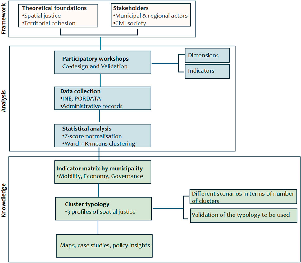
Figure 1. Schematic representation of the Território.justo.pt methodological workflow.
3.1 Framework and indicators
Acknowledging the historical marginalisation of spatial planning in Portugal (Giannakourou, 2005), the project brought together perspectives from urban planning, geography, economics, and engineering to c develop an analytical tool. At the heart of this process were collaborative workshops designed to promote dialogue between experts, practitioners, and local actors.
The participatory dimension involved a diverse group of stakeholders from both public and private sectors. These included municipal technicians and planners, regional coordination commissions (CCDRs), and national bodies concerned with territorial cohesion, such as the Directorate-General for Territorial Planning and Urban Development (DGOTDU), the Agency for Development and Cohesion (AdC) and civic actors. Civil society organisations engaged in housing, mobility, and rural development were also invited to contribute, particularly during the phase of indicator validation and refinement. This stakeholder configuration ensured that the analytical framework was not only scientifically robust but also institutionally grounded and socially relevant.
These workshops followed transdisciplinary principles (Nicolescu, 2002), fostering the integration of academic, technical and experiential knowledge. They pursued two main objectives:
1. Co-designing the analytical framework, including selection of dimensions and indicators of spatial justice;
2. Validating and refining the dataset through iterative feedback and collective reflection.
The first workshop identified the core analytical dimensions of spatial justice, aligning them with the objectives of European territorial cohesion policy. The second focused on territorialising injustice, exploring where, how, and why inequities manifest at the municipal level. Through these discussions, the project established three central dimensions for analysis: mobility–commuting patterns, modal split, motorisation rates; economy–productivity, employment, business density, income inequality; governance–electoral participation, transparency, and community involvement in public investment. These reflect both academic theory and priorities articulated in the PNPOT (República Portuguesa, 2019).
The workshops also included internal reflection sessions among the project team–urbanists, architects, geographers, engineers–to test assumptions and consolidate methodological decisions.
Indicators were selected collaboratively, based on relevance, comparability, and data availabilty, with sources including INE and PORDATA. This work resulted in a municipality-level database which formed the basis for subsequent statistical analysis.
3.2 Analysis approach
To uncover spatial patterns and classify municipalities, a two-phase cluster analysis was performed using SPSS. The process began Ward’s hierarchical method to identify natural groupings and determine the optimal number of clusters. This was followed by K-means clustering to finalise the categorisation based on similarities across the selected indicators. All variables were standardised using z-scores to ensure comparability.
Importantly, the clusters were not treated as static or definitive outcomes. Instead, they served as starting points to deeper analysis, including the selection of case studies. These were chosen to illustrate the diverse expressions of spatial injustice and were informed by both the statistical results and participatory local inputs. This triangulated methodology–integrating data, expert stakeholder, and local experience–enabled a nuanced, context-sensitive diagnosis of spatial justice across the country.
4 Findings and policy relevance
The analytical process led to the classification of Portuguese municipalities into three main clusters, each reflecting distinct configurations of spatial justice across the dimensions of mobility, economy, and governance. These clusters illustrate how spatial inequalities are shaped by a combination of structural conditions, infrastructure access, administrative capacity, and civic engagement.
4.1 Spatial patterns and cluster analysis
The cluster analysis, performed using Ward’s method and refined through the K-means clustering, produced a typology of municipalities with shared characteristics. All indicators were z-score standardised to ensure comparability.
• Cluster 1 includes primarily urban municipalities, marked by high economic output, strong governance indicators, and diverse mobility systems. However, even within this group, issues such as increased car dependency and traffic congestion challenge the mobility dimension.
• Cluster 2 comprises intermediate or peri-urban areas, with mixed economic performance and moderate governance capacity. These municipalities often lack adequate public transport, leading to car dependence, and reflect a transitional dynamic between urban opportunities and rural limitations.
• Cluster 3 represents peripheral and rural municipalities, typically characterised by low economic productivity, weaker governance, and limited access to services. High unemployment, low public transport usage, and minimal community participation make these areas especially vulnerable to spatial injustice.
• Cluster 4 includes isolated rural municipalities, marked by low population density, geographic remoteness, and weak connectivity to higher-level centres. These areas face compounded challenges in service access, mobility, and governance, reinforcing territorial exclusion despite strong informal community ties.
The geographic distribution of these clusters, illustrated through thematic mapping (see Figure 2), confirms a persistent centre-periphery divide: municipalities in the Lisbon Metropolitan Area and parts of the North are concentrated in Cluster 1, while much of the interior and South regions align with Cluster 3. This regional imbalance reinforces long-standing development asymmetries in Portugal.
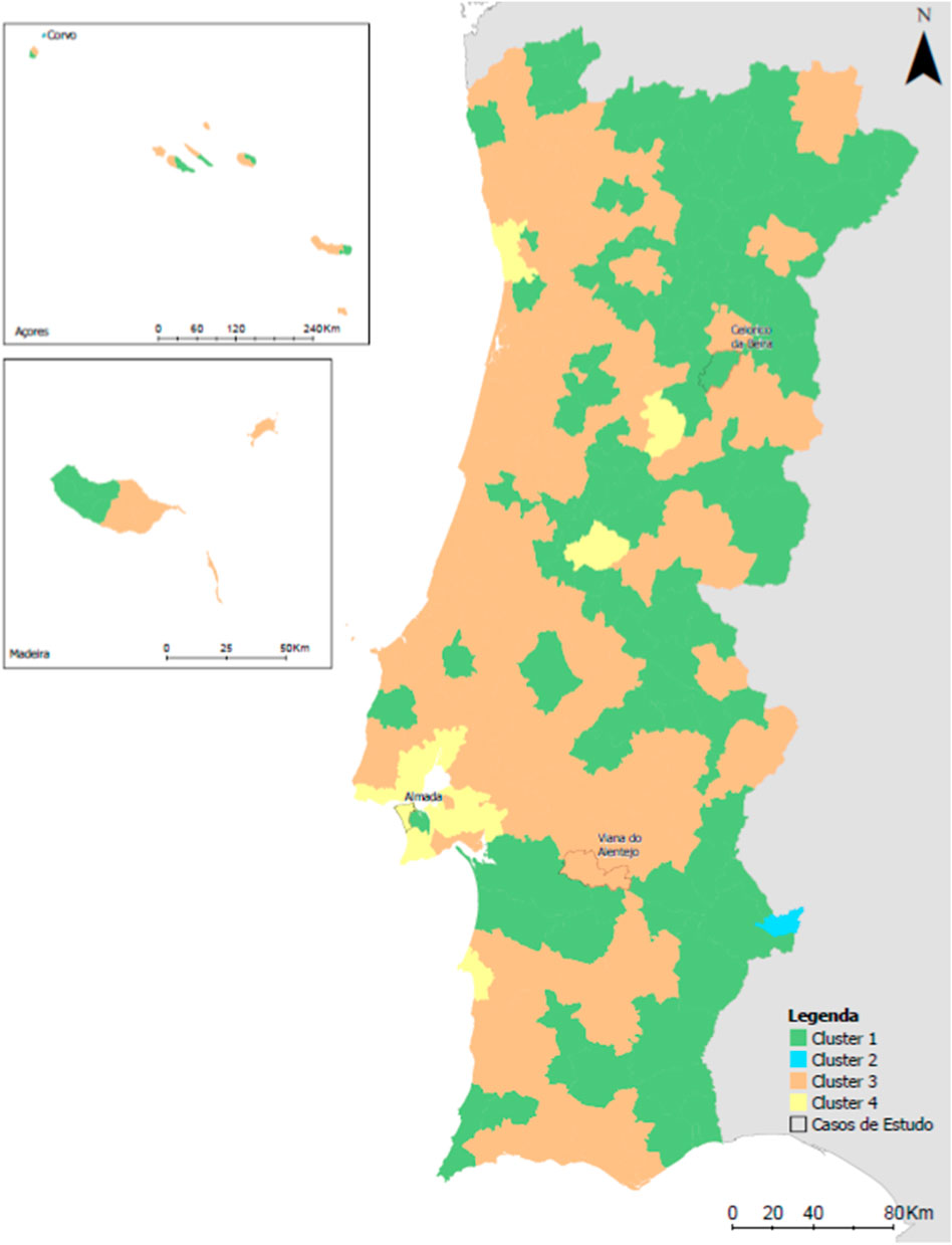
Figure 2. Geographic distribution of municipalities by spatial justice cluster.
4.2 Case studies
The four case studies were selected to exemplify the diversity of territorial conditions captured in each cluster. The methodology adopted to obtain these case studies made it possible to identify the municipalities that most accurately represent the characteristics of each cluster to which they belong:
• Urban Municipality–Almada, refers to a dense metropolitan area in the Lisbon region with high GDP per capita, advanced mobility networks, but growing spatial pressures related to housing and traffic.
• Intermediate Municipality–Celorico da Beira, is a mid-sized centre, exhibiting moderate economic and governance indicators but structural weaknesses in intermodality and technical capacity.
• Peripheral Municipality–Viana do Alentejo, is a low-density rural municipality in the Alentejo, with limited access to public services, low civic engagement scores, but strong informal community ties.
• Isolated Municipality–Barrancos, in addition to being a rural municipality with low population density, difficulties in accessing a range of services and weak civic engagement, it is also significantly distant from a more higher-level administrative centres.
To complement the statistical results, four case studies–each drawn from a different cluster–provided qualitative depth and context-specific insights.
• In Urban Municipality, despite strong economic indicators and service access, participants highlighted ongoing challenges with housing affordability and transport congestion, revealing that spatial justice must consider more than just performance metrics.
• In Intermediate Municipality, planners stressed the gap between available funding and implementation capacity, showing how technical and institutional weaknesses can delay or block progress despite moderate resources.
• In Peripheral Municipality, local engagement revealed strong community ties but limited influence in formal governance processes. This case underscored the importance of empowerment and voice, alongside infrastructure provision, in promoting spatial justice.
• In Isolated Municipality, the combination of low population density, reduced access to public services, and significant distance from higher-level administrative centres highlighted how geographic remoteness intensifies spatial exclusion and demands more tailored policy responses.
These examples demonstrate that quantitative analysis alone is insufficient: participatory insights are essential to understand how injustice is lived and perceived on the ground. They also show that different territories require differentiated policy responses.
4.3 Discussion of data challenges
A recurring limitation throughout the project was the incomplete and inconsistent availability of governance-related data, such as indicators on transparency and civic participation. Many municipalities lack up-to-date or comparable records, and fragmented data systems further complicate the integration of qualitative and quantitative approaches.
These limitations highlight the need for stronger institutional transparency and data governance at the municipal level. Without reliable, standardised data, it is difficult to systematically monitor spatial justice or evaluate the impact of territorial policies over time.
Nonetheless, by combining participatory methods, robust statistical tools, and territorial knowledge, the project succeeded in building a solid foundation for spatial justice analysis–one that is evidence-based, actionable, and sensitive to local realities.
5 Policy implications
The Território.justo.pt framework offers significant potential for informing public policies aimed at reducing territorial disparities. By translating the abstract principles of spatial justice into a practical, data-driven, and participatory model, it provides a valuable tool for planners, decision-makers, and institutions at different level of governance.
5.1 Adaptability for planning agencies
The framework can be integrated into territorial planning instruments, such as municipal master plans (PDMs), inter-municipal development strategies, or regional action plans. Its modular structure–built around the dimension of mobility, economic, and governance–enables flexibility across diverse territories and governance contexts.
Importantly, the participatory component strengthens the legitimacy and local relevance of planning processes, particularly in place-based planning approaches promoted by EU cohesion policy. By involving local actors in the diagnosis and co-creation of solutions, the framework fosters a stronger sense of ownership and enhances implementation feasibility.
5.2 Supporting EU cohesion and investment strategies
The use of indicator-based clusters enables more evidence-informed allocation, particularly in line with the objectives of EU Cohesion Policy and national recovery and resilience plans. By identifying municipalities with heightened spatial injustices, the framework supports more strategic and targeted funding, moving beyond one-size-fits-all models with tailored interventions that reflect local challenges.
This has direct relevance for improving the effectiveness and fairness of funding distribution, especially in contexts where traditional redistribution mechanisms have failed to reduce inequalities.
5.3 Strengthening data governance and transparency
A key insight from the project is the urgent need to strengthen data governance at the municipal level. Many of the difficulties encountered in applying the framework stemmed from gaps in data availability–particularly regarding governance indicators such as civic participation, transparency, and service coverage.
To enable systematic spatial justice monitoring, institutional reforms are needed to ensure that data is collected in a standardised, interoperable, and regularly updated manner. Promoting open access to relevant datasets will not only improve policy responsiveness but also enhance public accountability and civic engagement in planning processes.
5.4 Adaptability and transferability
Although the Território.justo.pt project was developed for the Portuguese context, its architecture was designed with the possibility of replication in mind. Three features enable adaptation to other national, regional and local contexts:
• Modular structure–The framework is composed of flexible dimensions (e.g., mobility, economy, governance) and indicators that can be redefined according to local relevance, data availability, or policy priorities. For instance, regions with strong decentralised health or education systems might prioritise those domains within the justice assessment.
• Methodological reproducibility–The process, from participatory indicator co-design to cluster analysis, is replicable using widely available tools (e.g., SPSS, R, or Python), provided that minimum data conditions are met. The approach combines normative grounding (justice principles), empirical data (municipal indicators), and deliberative validation (stakeholder engagement), which together support context-sensitive replication.
• Institutional and data preconditions–Application elsewhere requires a minimum degree of territorial disaggregation in official statistics, and institutional actors open to participatory planning. National statistical agencies, regional development bodies, and municipal networks are likely entry points for adaptation.
As such, the framework could be tested in other countries with multilevel governance structures where spatial inequality is severe but underdiagnosed. In each case, local adaptation should be developed together with local actors, reflecting the principle that spatial justice is not universal but always contextualised.
6 Conclusion
The Território.justo.pt project marks an important step toward the operationalisation of spatial justice in Portugal. By integrating theoretical frameworks, stakeholder engagement, and data-driven analysis, the project demonstrates how a complex and often abstract concept can be translated into practical tools for territorial diagnosis and policy design.
The analysis shows that territorial disparities in Portugal are multifaceted, rooted not only in economic or demographic trends, but also in uneven access to mobility, governance capacity, and institutional resources. The classification of municipalities into three spatial justice profiles–urban, intermediate, and peripheral–highlights enduring patterns of imbalance shaped by historical trajectories and structural limitations.
A core contribution of the project is its emphasis on participatory methods. The workshops, built on transdisciplinary principles, were crucial in aligning theoretical models with local realities. This hybrid methodology, combining statistical rigour with grounded local knowledge, reinforces the value of mixed methods approaches in spatial planning and territorial governance.
Despite its contributions, the project also revealed persistent barriers–namely, the lack of standardised and accessible governance indicators data. Addressing the limitations will be essencial to support future assessments and to strengthen transparency, equity, and responsiveness in spatial policies. Improving data infrastructures and civic participation mechanisms is not only necessary for spatial justice, but also for the broader democratic resilience of territorial governance systems.
Looking forward, the Território.justo.pt framework is both scalable and adaptable. It holds potential for application in other national and regional contexts and cloud be enhanced through longitudinal monitoring, integration with climate justice variables, or the development of policy simulation tools. Ultimately, this work contributes to a growing field of research that treats space not as a passive backdrop, but as an active domain of rights, responsibilities, and intervention–a field where justice is not assumed, but deliberately pursued.
Author contributions
JG: Writing – original draft, Investigation, Conceptualization, Writing – review and editing. SJ: Investigation, Writing – original draft. FN: Writing – original draft, Conceptualization. JA: Investigation, Writing – original draft, Conceptualization, Formal Analysis. PV: Conceptualization, Writing – original draft. RM: Writing – original draft, Formal Analysis, Investigation, Methodology. HC: Formal Analysis, Writing – original draft.
Funding
The author(s) declare that financial support was received for the research and/or publication of this article. This work has been funded by national funds, Fundação para a Ciência e a Tecnologia (FCT) in the framework of project UIDB/05703/2020 from the research unit CiTUA.
Conflict of interest
The authors declare that the research was conducted in the absence of any commercial or financial relationships that could be construed as a potential conflict of interest.
Generative AI statement
The author(s) declare that no Generative AI was used in the creation of this manuscript.
Publisher’s note
All claims expressed in this article are solely those of the authors and do not necessarily represent those of their affiliated organizations, or those of the publisher, the editors and the reviewers. Any product that may be evaluated in this article, or claim that may be made by its manufacturer, is not guaranteed or endorsed by the publisher.
References
European Union. (2007). Leipzig Charter on Sustainable European Cities. Leipzig: Informal Ministerial Meeting on Urban Development and Territorial Cohesion.
European Union. (2020). Territorial Agenda 2030: a future for all places. Publications Office of the European Union. ec.europa.eu
Ferrão, J. (2010a). The Portuguese experience in spatial planning and policy: a discursive formation in transition. Cid. Comunidades Territ. (20), 21–40.
Ferrão, J. (2010b). Governança e ordenamento do território: reflexões para uma governança territorial eficiente, justa e democrática. Prospect. Planeam. 17, 129–139. repositorio.ulisboa.pt.
Giannakourou, G. (2005). Transforming spatial planning policy in Mediterranean countries: europeanization and domestic change. Eur. Plan. Stud. 13 (3), 319–331. doi:10.1080/0365431042000321857
Healey, P. (2012). The universal and the contingent: some reflections on the transnational flow of planning ideas and practices. Plan. Theory 11 (2), 188–207. doi:10.1177/1473095211419333
Hopwood, B., Mellor, M., and O’Brien, G. (2005). Sustainable development: mapping different approaches. Sustain. Dev. 13 (1), 38–52. doi:10.1002/sd.244
Kunzmann, K. R. (2011). Territorial cohesion: a misguided policy concept? Plan. Pract. and Res. 26 (2), 157–165.
Madanipour, A., Shucksmith, M., and Brooks, E. (2022). The concept of spatial justice and the European Union’s territorial cohesion. Eur. Plan. Stud. 30 (5), 807–824. doi:10.1080/09654313.2021.1928040
Marcuse, P. (2010). “Spatial justice: derivative but causal of social justice,” in Justice et Injustices Spatiales. Editors B. Bret, P. Gervais-Lambony, C. Hancock, and F. Landy (Nanterre, France: Presses Universitaires de Paris Nanterre), 76–92.
Musaád, M. A. (2025). Contextualizing asymmetric decentralization in papua in the context of sustainable development goals. J. Lifestyle SDGs Rev. doi:10.47172/2965-730x.sdgsreview.v5.n01.pe04705
Pieterse, E. (2008). City futures: confronting the crisis of urban development. London, United Kingdom: Zed Books.
República Portuguesa (2019). Lei n.º 99/2019 – Primeira revisão do Programa Nacional da Política de Ordenamento do Território (PNPOT). Diário República, 1.a série, n.º 170, 3–267. diariodarepublica.pt.
Rocha, J. (2012). Urban planning in Portugal: instruments, policies, and actors. Finisterra XLVII (94), 93–113.
Rudy, E., and Supriyadi, A. A. (2025). Security policy transformation to accelerate the achievement of the sustainable development goals (SDGs) in papua. Preprints. doi:10.20944/preprints202501.1975.v1
Sá Marques, T., Guimarães, M. H., and Madanipour, A. (2018a). Spatial justice and the European Union’s cohesion policy. Regional studies. Regional Sci. 5 (1), 104–113.
Sá Marques, T., Saraiva, M., Santinha, G., and Guerra, P. (2018b). Re-thinking territorial cohesion in the European planning context. Int. J. Urban Regional Res. 42 (3), 547–572. doi:10.1111/1468-2427.12608
Keywords: spatial justice, territorial cohesion, participatory planning, cluster analysis, territorial governance
Citation: Gonçalves J, Jorge S, Nunes da Silva F, Amorim J, Vale de Paula P, Marques R and Cepni H (2025) Operationalizing spatial justice: a transdisciplinary framework for territorial equity in Portugal. Front. Built Environ. 11:1616966. doi: 10.3389/fbuil.2025.1616966
Received: 23 April 2025; Accepted: 30 June 2025;
Published: 30 July 2025.
Edited by:
Wei Lang, Sun Yat-sen University, ChinaReviewed by:
SriPallavi Nadimpalli, Independent Consulting, Bengaluru, IndiaCopyright © 2025 Gonçalves, Jorge, Nunes da Silva, Amorim, Vale de Paula, Marques and Cepni. This is an open-access article distributed under the terms of the Creative Commons Attribution License (CC BY). The use, distribution or reproduction in other forums is permitted, provided the original author(s) and the copyright owner(s) are credited and that the original publication in this journal is cited, in accordance with accepted academic practice. No use, distribution or reproduction is permitted which does not comply with these terms.
*Correspondence: Sílvia Jorge, c2lsdmlham9yZ2VAdGVjbmljby51bGlzYm9hLnB0