 Yifan Wang1
 Junling Zhou
- 1 Academy of Arts, Huangshan University, Huangshan, China
- 2 Faculty of Innovation and Design, City University of Macau, Taipa, Macao SAR, China
- 3 College of Fine Arts, Guangdong Polytechnic Normal University, Guangzhou, China
Introduction: As one of the cities with the highest population density in the world, Macau has long faced the issues of insufficient public green spaces and uneven spatial distribution. This study focuses on 18 public green spaces in the Youhan and Taishan communities, where the population density exceeds 104,000 people per square kilometer.
Methods: Utilizing road and green spaces data released by the IAM (INSTITUTO PARA OS ASSUNTOS MUNICIPAIS) and field research results, a spatial model was constructed in AutoCAD. Multi-scale spatial syntax indicators, including global integration, local integration (r = 3), synergy (n = 200 and n = 400), and selection, were calculated through Depthmap Beta 1.0.
Results: The results indicate that the average global integration of the street network is 1607.97, while the average for public green spaces is 1976, with a maximum of 2770.4 and a minimum of 1134.08, showing significant regional differences. The synergy coefficient of the street network reaches 0.93–0.99, indicating a high degree of consistency between local and overall structures. However, some small green spaces have low utilization rates due to their single function, insufficient connectivity, and lack of age-friendly facilities.
Discussion: Addressing these mismatch issues, this article proposes optimization strategies based on the “agefriendly” concept and maps them to the eight dimensions outlined in the World Health Organization (WHO) (2007) “Global Age-Friendly Cities:” spatial friendly strategies correspond to outdoor spaces, buildings, and transportation systems; service-friendly strategies emphasize multifunctionality and health support facilities; policy support strategies highlight inclusivity, citizen participation, and governance transparency. By combining quantified spatial accessibility indicators with the internationally recognized age-friendly framework, this study provides a robust and scalable approach for equity-oriented green space planning in Macau and other high-density cities.
1 Introduction
As one of the cities with the highest population density globally, Macau has long been confronted with the dual challenges of insufficient public green spaces and uneven spatial distribution—issues that are not unique to Macau but rather typical of ultra-high-density urban areas worldwide (Al-Qawasmi, 2019). A study on urban quality of life pointed out that when public green spaces cannot expand in area or improve in function with population growth, residents’ dissatisfaction with the living environment will significantly intensify, and this dissatisfaction is particularly prominent among different age groups (Han et al., 2021). A lack of age-inclusive design will further amplify the contradiction between green space supply and demand for all ages. This conclusion is particularly relevant to the situation in Macau: according to the 2023 census data from the Macau Statistics and Census Bureau, the overall population density in Macau is 20,600 people per square kilometer, which can be further divided into 13.2% children (0–14), 72.8% working age (15–64), and 14% older people (65 years old and above). In contrast, the Youhan and Taishan communities located in the northern part of the Macau Peninsula have a staggering population density of 104,400 people per square kilometer due to their unique location, far exceeding the threshold of 15,000 people per square kilometer proposed in international research for high-density cities. Among them, the proportion of children (0–14) is lower than the city average, and the proportion of older people exceeds 15% (Delhey et al., 2002). In this context, the per capita green space in these two communities is extremely limited and scattered. It is urgent to quantify and solve the mismatch between green space supply and demand for all ages and to optimize green space accessibility based on age-inclusive design principles (Wang, 2004; Flynn et al., 2002).
To fill this research gap, this study first screened the public green spaces of Youhan and Taishan communities that are clearly listed on the website of the IAM. Through field research, 18 highly representative public green spaces were ultimately selected as the research objects, including the Guanzha Rest Area, Ruyi Square, Heisha Ring Park, and Zhongshan Memorial Municipal Park. The selection of these green spaces is based on three key reasons, supported by empirical observations and early characteristics of age-inclusive design, standardization, and representativeness: their shape and area comply with the Macau Urban Green Space Classification Standards; their plant diversity is significantly higher than the average level of high-density urban community green spaces (Button, 2002), making them typical cases of urban green space integration in Macau; due to their proximity to residential areas, these green spaces are the core destinations for local residents seeking outdoor leisure and have high utilization potential (Yin et al., 2008). An on-site investigation found that the main leisure activities of surrounding residents are carried out in these public green spaces, ranging from children’s play to adults’ socialization to older people’s healthcare. The usage scenarios of various age groups are concentrated here, reflecting their practical value for the daily life of all ages. The areas are relevant to the research because they cover different types of green spaces defined by IAM (MG11: urban parks, MG12: urban gardens, MG13: suburban parks).
The core objective of this study is to address the spatial equity issues of green spaces in high-density communities through quantitative accessibility analysis and all-age-oriented optimization. Specifically, using road and green space data from IAM combined with field research results, we constructed a pedestrian network model to:
1. Identify service blind spots in high-demand areas (such as residential clusters with a high proportion of older and working-age populations, and school areas with high concentrations of children), and analyze the lack of accessibility in the “age inclusiveness dimension” of these areas (Farage et al., 2012).
2. Analyze spatial barriers to accessing green spaces caused by road network defects (such as missing crosswalks and dead-end roads)—an issue also highlighted by Chamaret et al. (2007) in their research on urban spatial connectivity.
3. Revealing the inherent correlation mechanism between the imbalance of spatial fairness in green space layout and the lack of age inclusiveness, providing empirical support for how to apply the principle of age inclusiveness to propose optimization strategies in the future.
Ultimately, this study aims to explore an “age friendly” public green space model that deeply aligns with age-inclusive design principles. By designing to alleviate the contradiction between high population density and limited green space, it ensures that children can safely and conveniently reach recreational areas, while allowing older people to easily access health and wellness facilities. At the same time, it meets the social and recreational needs of adults. This goal is in line with the urban development concept advocated by Wang (2010) and Friedman (1997), which is “people-oriented and age sharing.”
2 Literature review
2.1 Research on accessibility of public green spaces in high-density cities
The global evolution of urban public green spaces reflects a shift from “form-driven” to “function-driven” planning, and ultimately to “people-oriented” planning. Subedi et al. (2025) traced the development of Western green spaces back to 19th-century Britain, where early designs focused on landscape aesthetics (e.g., formal gardens), while later iterations emphasized functional diversity (e.g., integrating recreation and ecological protection). In contrast, the construction of public green spaces in China has gone through distinct phases: the earliest recorded park, the Xuanniao Nursery of the Yellow Emperor (dating back 3,000 years), served ritual purposes; modern construction, influenced by Western socialist countries, prioritized large-scale afforestation; and after the reform and opening-up period, green spaces became a key component of urban planning. By the late 1980s, the number of national parks had reached 679 (Zhuang, 2003), laying the foundation for contemporary research on urban green space systems.
Macau’s public green space system possesses unique characteristics rooted in its historical and administrative context. The IAM (2019) defined public green spaces as “open areas around residential areas equipped with recreational facilities,” specifying a minimum area of 500 square meters and referring to them as “open spaces” in practice (Yu and Jiang, 2021). This classification is aligned with international standards: Macau’s community parks (classified as MG11 under recreational green spaces) correspond to “neighborhood parks” in Western countries and “community green spaces” in Hong Kong, all of which share the core function of providing leisure services for local residents (Lynch, 2003). However, Macau’s community green spaces differ in terms of scale and layout—most are small (ranging from 500 m2 to 1,000 m2) and located along streets or within residential clusters, which limits their functional diversity compared to larger urban parks in Hong Kong or Singapore (She and Tan, 2014).
The international research on the accessibility of high-density urban public green spaces focuses on methodological innovation and cross-city comparison, especially delving into the special characteristics of super-dense cities such as Macau, providing a scientific basis for spatial optimization. The evaluation method has been upgraded to “subjective and objective integration.” Traditional models have biases due to neglecting quality perception. In 2024, the improved two-step floating catchment area (2SFCA) method innovatively incorporates social media sentiment analysis (sentiment knowledge enhanced pre-training (SKEP) model) and scale index (SI), taking into account residents’ subjective evaluations and objective attributes of green spaces, and correcting the underestimation of accessibility to small and medium-sized green spaces. Fairness assessment has extended from the geographical distribution level to the social dimension. A study in Singapore used the Gini coefficient, the Atkinson index, and the Theil entropy index to evaluate the fairness of heat mitigation services in public green spaces. The results showed that low-income groups and migrant workers face a greater gap in obtaining cooling benefits. A comparative study between London and Shanghai shows that the mismatch between public green space supply and population density is the main cause of unequal accessibility in the central areas of high-density cities in Asia. The practice in Oslo further proves that incorporating public green spaces into the “15 minute city” framework can narrow the social spatial differences in green space accessibility (Battiston and Schifanella, 2024).
A critical gap in existing research is the lack of quantitative analysis on green space accessibility in Macau’s ultra-high-density communities. While international studies (Oh and Jeong, 2007) have linked green space layout to resident satisfaction, research specific to Macau has primarily focused on qualitative descriptions of green space types, failing to address how spatial distribution and functionality meet the needs of diverse age groups.
2.2 Spatial syntax theory
Spatial syntax, formally proposed by Bill Hillier and Julienne Hanson in their 1984 book The Social Logic of Space, is a theoretical and methodological framework for analyzing the relationship between spatial morphology and social behavior. Hillier (1984) argued that spatial patterns shape human activities by influencing “spatial freedom”—that is, the ease of movement and interaction within a space. Since then, this theory has been refined by international scholars: Cetin (2015) applied it to urban land use planning to identify high-activity areas; Sanchez-Sepulveda et al. (2024) combined it with GIS and social network analysis to predict the development of urban centers; and Oh and Jeong (2007) used it to evaluate park accessibility—all demonstrating its versatility in urban research.
For studies on public green spaces, the core parameters of spatial syntax provide a quantitative basis for measuring accessibility (Wang and He, 2007). Connection value: The number of adjacent spaces visible from a given point, reflecting the permeability of the local space; Integration value: The total number of steps required to reach all other spaces from a given point; “Global integration” (at the city/community scale) and “local integration” (e.g., r = 3, a 3-step radius) capture different levels of accessibility; Depth: The minimum number of steps between a given space and all other spaces, indicating the degree of spatial isolation; Selection degree: The probability of a space appearing on the shortest path, reflecting its role as a “traffic hub”; Synergy coefficient: The consistency between local and global spatial structures, used to assess perceived accessibility (e.g., in road networks of tourist attractions).
These parameters in green space research are applied to identify mismatches between road network connectivity and green space layout. For instance, Dawson (2002) used integration values to show that green spaces with low global integration are often underutilized, even if they are functionally complete. This insight informs the methodology of this study, which uses spatial syntax to quantify how the structure of Macau’s road network affects residents’ access to green spaces.
2.3 Overview of high-density communities in Macau
Macau’s high-density communities, particularly Youhan and Taishan, have a unique historical trajectory that has shaped their current urban form. Li and Ye (2015) documented that the land connecting Macau and Zhuhai was originally a sandbank formed by river sedimentation. Land reclamation began in the 1930s, under Portuguese administration, and facilities such as racecourses and relief housing (“Barbosa Fang”) were constructed. By the 1990s, economic development led to the conversion of agricultural land into large-scale residential areas, eventually forming the Youhan and Taishan communities we see today, which are characterized by ultra-high population density, aging infrastructure, and inadequate public facilities.
In terms of public green space utilization, the Youhan and Taishan communities face three significant challenges, detailed below.
Demographic structure and spatial conditions impose dual constraints. According to the research by Li and Xing (2021), the main residents of the Youhan community are new immigrants to Macau, mainland migrant workers renting local apartments, low-income older people living alone, and people with disabilities. This group has a strong demand for public green spaces with high accessibility. However, the per capita residential area in this community is less than 15 square meters, leaving residents with severely limited indoor leisure space. As a result, they have no choice but to rely on public green spaces as the core venue for outdoor leisure activities, which directly leads to a sharp increase in the carrying pressure on existing green space facilities and a continuous intensification of the supply-demand contradiction.
There are obvious deficiencies in the design and functional configuration of green spaces. Through field research, Wang et al. (2023) pointed out that most public green spaces in the communities have three typical problems: low vegetation coverage results in poor shading effects, with bare ground accounting for more than 40% of the area in some small green spaces; nighttime lighting facilities are either missing or have insufficient illumination intensity, failing to meet residents’ safety needs for evening use; and the functional layout is single—most green spaces are only equipped with basic lawns or simple resting benches, lacking dedicated functional spaces such as children’s play areas and fitness facilities for older people. Ashihara (2006) also emphasized that such design deficiencies can lead to the phenomenon of “spatial idleness:” although public green spaces exist in physical form, their poor practicality prevents them from providing high-quality leisure experiences for residents (Al-Qawasmi, 2020). Consequently, their social value in promoting community interaction and ecological value in regulating the local microclimate are both significantly diminished.
There is a mismatch between the functions of green spaces and residents’ cultural and social needs. The residents of the Youhan and Taishan communities include new immigrants from different regions of the Chinese mainland, local older residents with long-term residency, and cross-border migrant workers. Against this backdrop of cultural diversity, residents have a clear demand for public green spaces to serve as “carriers of cultural exchange,” such as hosting regional cultural exhibitions and collective neighborhood activities. However, the existing public green spaces lack spatial configurations that meet such needs—there are neither open spaces capable of accommodating collective activities nor semi-enclosed spaces supporting small-scale communication. This prevents green spaces from effectively playing their role in fostering a sense of community identity and promoting cultural integration, further weakening their supporting role in building social cohesion in high-density communities.
2.4 All-age-friendly community
As an important unit of the urban system that carries citizens’ daily lives, the quality of community living space deserves to be explored in depth by scholars (Wang and Wang, 2011). After a community has met its basic functional needs, people begin to pursue higher psychological goals, and open space is an important component affecting the quality of life of residents (Wang, 2011). Major concerns of today’s society are how to improve the quality of the community and the quality of life of community residents and how to meet the important goal of the people’s growing aspirations for a better life (Wang and Chang, 2021).
This concept evolved into a global framework with the release of the World Health Organization’s Global Age-Friendly Cities, which outlines eight dimensions (including outdoor spaces, transportation, and health support) for building inclusive urban environments (World Health Organization, 2007).
On this basis, the academic community further refined the age-inclusive design principle, whose core is to break the age label restrictions and cover the full life cycle needs of people by adapting to the differences in physiological, cognitive, and behavioral habits among different age groups, from children, to youth, to older people, and ultimately achieving a “ageless” friendly experience. It is not designed for a single group (such as “elderly design” or “children’s design”), but through flexible and compatible solutions, it enables users of all ages to use products or environments safely, conveniently, and with dignity. These principles are not only a concrete response to the “needs of all ages” but also a key bridge connecting theoretical frameworks with practical implementation.
For high-density cities like Macau, all-age-friendly communities are not only a goal for improving quality of life but also a practical solution to land scarcity. Keyes et al. (2011) pointed out that compact and multifunctional public spaces (including green spaces) can maximize land use efficiency while meeting the needs of cross-age groups. However, community planning in Macau has not fully integrated the above design principles. Most green spaces lack accessible facilities based on “inclusiveness” (such as no elderly-friendly handrails), elastic spaces based on “adaptability” (single and fixed functions), and a participatory resident governance mechanism, resulting in a disconnect between facility configuration and the needs of all ages (such as no nursing seats in children’s play areas and no emergency protection in rest areas for older people). This reflects the gap between international standards, design principles, and local practices. The aim of this study is to fill this gap by combining spatial accessibility analysis with the WHO Age-friendly Framework and Age-friendly Design Principles and providing a specific path for the age-friendly optimization of high-density communities in Macau.
3 Research methodology
3.1 Scope of study
In the 1930s, the Macau government vigorously developed and constructed the city, carrying out large-scale land reclamation within the scope of the main island of Macau. This was the period when the Youhan and Taishan communities began to take shape, accommodating a large influx of refugees from mainland China and impoverished people from Macau. This area best reflects the daily life patterns of the people in the current North District of Macau. According to the 2023 population census data from the Macau Statistics and Census Service, the population density of Macau is 20,600 people per square kilometer. However, in the Heisha Ring and the Youhan and Taishan communities located in the northern part of the Macau Peninsula, the population density reaches 104,400 people per square kilometer 1 . The Youhan and Taishan communities encompass a rich tapestry of amenities, including transportation hubs, cultural and sports facilities, commercial complexes, residential areas, and various public green spaces. They are very high-density communities.
The first step is to focus the research scope on the northern district of Macau (Youhan and Taishan communities) to ensure that the research is concentrated on the area with the highest population density in the Macau Special Administrative Region.
Table 1 identifies the public green spaces selected in the second step according to the “Classification Standards for Urban Green Spaces in Macau” issued by the Macau Municipal Government in 2019, mainly consisting of urban parks, city parks, and country parks. Based on the statistical results of the IMA Natural Resources Network and field research, 18 public green spaces within the research scope were finally determined to meet the criteria specified in the “Classification Standards for Urban Green Spaces in Macau” 2 .
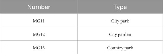
Table 1. Types of green spaces in Macau formulated by the Municipal Affairs Bureau of Macau (2019).
Figure 1 identifies parks and garden green spaces. These are green areas designated for residents, characterized by their openness and primary recreational functions. They serve multiple purposes, including beautifying the landscape and disaster prevention and mitigation, and are equipped with recreational and service facilities. These spaces can vary in size and encompass both parks and gardens. The scope of this study includes the Sun Yat-sen Memorial Municipal Park, Youhan Park, Yachang River Nursery, Triangle Garden Rest Area, and Heisha Ring Park.
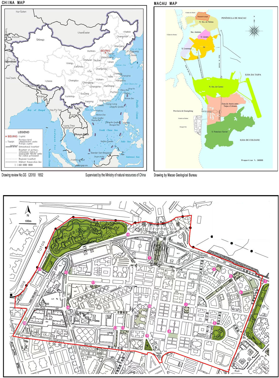
Figure 1. Regional map of Macau, China, and distribution of green spaces in research areas, adapted from the Municipal Affairs Bureau of Macau (2022).
Green spaces in recreation areas: The remaining areas within the scope of this study are recreation areas, which are characterized by small size, limited facilities, few plant species, simple design, high accessibility, and high population density. These green spaces provide leisure opportunities for residents in the area and serve both recreational and urban road traffic functions 3 .
3.2 Space syntax
Space syntax is a social, economic, and cultural behavior theory and method based on spatial morphology analysis, formally proposed by Bill Hillier and Julienne Hanson of University College London in 1984 in their book “The Social Logic of Space,” which proposed spatial syntax and further pointed out the function of space, reflecting the logical and statistical characteristics of society, demonstrating the impact of spatial patterns on people’s social activities. By studying the spatial interactions between different regions, this theory reveals how people navigate and use their environment, thereby understanding how spatial design affects the flow patterns and quality of social interaction within communities (Benameur et al., 2024).
The essence of spatial syntactic accessibility is to “transform human perception of spatial accessibility (such as easy access/controllable paths) into computable topological and mathematical indicators,” and the key value setting is essentially a balance between spatial structural rationality and social behavioral reality. The mathematical constraints include theoretical indicators such as integration and selectivity, as well as differentiated requirements for functional scenarios such as transportation networks and building spaces. The model not only relies on dynamic calibration of empirical data, such as pedestrian flow and points of interest (POIs), but also responds to methodological innovations brought about by technological iterations, such as digital twins and machine learning.
For the streets with public green spaces in the Youhan and Taishan communities of Macau, various parameters such as integration value and synergy value were analyzed (Ojobo et al., 2024). The spatial syntax technical parameters are: 1. Connection value (the total number of adjacent spaces seen by a person standing in space). 2. Integration value (the most commonly used metric refers to the total number of steps required to travel from one space to other spaces). 3. Depth (the minimum number of connection steps from one space to all other spaces in the system) 4. Selection degree (the probability of node space appearing on the shortest path) 5. Synergy value (perceived accessibility, usually applied to road perception in tourist attractions).
3.3 Research analysis
The global accessibility of public green spaces identified in Figure 2 in the Youhan and Taishan communities is realized through the global integration value variable, which expresses the ease or difficulty for community residents to reach the public green spaces within the community. This was determined using Depthmap software to compute the line segment model of the road network of the Youhan community in Macau and classify the roads with different colors based on the results of the various syntactic variables (Hosseini et al., 2025). The warmer the color of the line, the higher the global integration of the road segment (i.e., the stronger the spatial aggregation between the public green spaces and the surrounding road network, which can withstand higher traffic flow and pedestrian intensity), the easier it is for community residents to reach the public green spaces, and the higher the accessibility of the road segment (Zhou et al., 2023). By aligning the distribution of public green spaces with the distribution map of global integration of roads, public green spaces can be evenly distributed in two communities. Few public green spaces are distributed in the core area of roadway global integration, and there is a mismatch between the layout of public green spaces and the accessibility distribution of the roadway network.
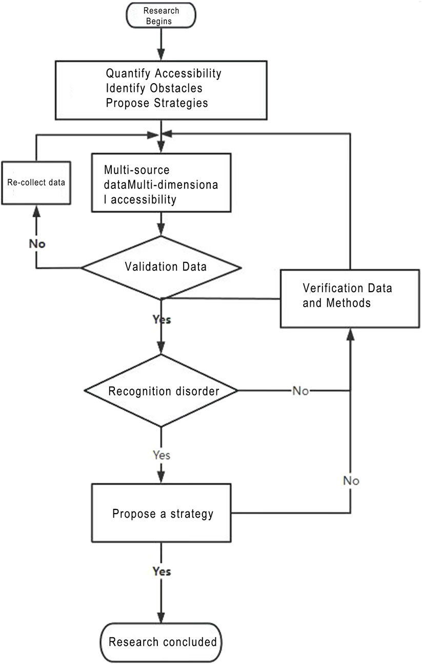
Figure 2. The flowchart of this study (drawn by the author).
3.3.1 Global accessibility analysis
Figure 3 classifies roads into different colors based on the results of various syntactic variables. Among them, the warmer the color of the lines, the higher the overall integration of the road section (i.e., the stronger the spatial clustering between the public green space and the surrounding road network, which can withstand more traffic flow and pedestrian intensity). The easier it is for residents in the district to reach public green spaces, the higher the accessibility. The distribution of public green spaces is overlaid with the global integration distribution map of roads for analysis and reveals that the average distribution of public green spaces is within two zones. There are not many public green spaces distributed in the core area of the global integration of roads, and there is a certain mismatch between the layout of public green spaces and the accessibility distribution of the road network. In Table 2, the global integration of the streets of the Taishan and Youhan communities of Macau is analyzed, and the average value of the global integration of the road is found to be 1607.97. Then, through the software and combining calculations for global accessibility, the 18 research objects of the Youhan and Taishan communities were found to have a mean global integration value of 1976, which is higher than the street global integration by 22.9%. There are 15 street public green spaces, accounting for approximately 83% of the total number of public green spaces. The public green spaces in Taishan and Youhan communities have higher-than-average accessibility performance. In addition to this, the difference between the two public green space global integration values is large. The highest degree of integration of the Caiyuanchang side of the street open space area of 2770.4, compared to the lowest rated area, which is the Side Street Yachang River Nursery in Choi Yuen Chung, with the lowest score of 1134.08. The difference is 1636.32, which indicates that the accessibility level of some public green spaces is on the low side. The reasons for this should be determined, and corresponding remodeling strategies should be proposed to improve the accessibility of public green spaces. The calculation follows as Equation 1:
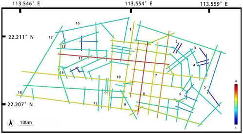
Figure 3. The axis map of the global integration of public green spaces in Youhan and Taishan. Source: Depthmap Beta 1.0, Author’s drawing (2022).
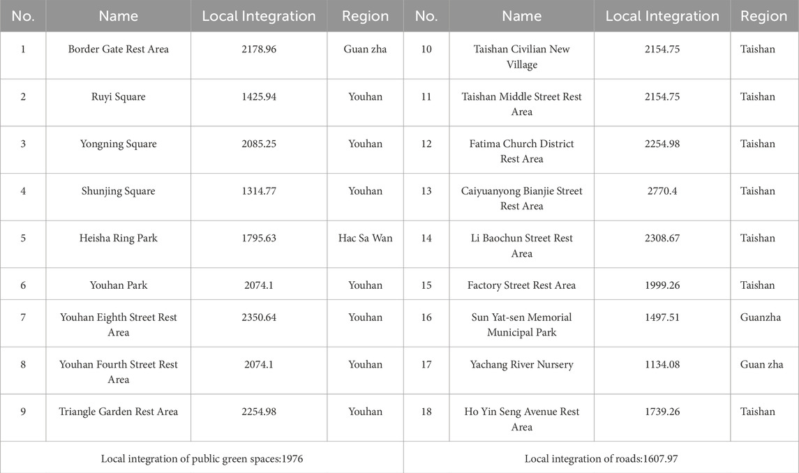
Table 2. Global integration of green spaces in Youhan and Taishan.
This formula is part of the spatial syntax analysis tool, which quantifies the accessibility differences of 18 green spaces at the Youhan and Taishan community scales, verifies the hypothesis of “mismatch between green space layout and population demand,” and studies whether there are high-accessibility green spaces in high-demand areas within the research scope:
3.3.2 Local accessibility analysis
This study will analyze the local accessibility of 18 public green spaces in Youhan and Taishan communities in Macau through local accessibility, which in spatial syntax indicates the connection between a node and nearby nodes within a few steps (i.e., the higher the local accessibility, the higher the local scope is also the center of people’s activities within the spatial scope of the local scope) (Zhou and Wang, 2023). Public green spaces serve as recreational areas for older people, children, and community residents. Therefore, in the setting of local integration indicators, the walking range is the main focus, and the “radius 3” integration degree is selected as an example of the road network system for spatial local integration analysis to identify whether green spaces can become local activity centers within a “5-10 minute walking circle” of high-density communities in Macau, and to solve the problem of “service blind spots in high demand areas. There is a high local accessibility green space around Taishan Civilian New Village (Sun and Luo, 2024).
The local accessibility line segment models of Youhan and Taishan communities, shown in Figure 4, were obtained through topological calculations, and then overlaid with 18 public green spaces. The graph shows that some public green spaces with lower values in global integration analysis have higher values in local integration. These areas are the Guanzha Rest Area, the Taishan Civilian New Village Rest Area, and the Taishan Middle Street Rest Area. The rest areas in Huadi Ma Church District, Triangle Garden Rest Area, and Youhan Eighth Street Rest Area are shown.
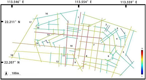
Figure 4. The axis map of the local integration of public green spaces in Youhan and Taishan. Source: Depthmap Beta 1.0, Author’s drawing (2022).
After conducting a partial integration analysis of the Youhan and Taishan community streets, we ranked the local accessibility of the Youhan and Taishan communities in Macau. As shown in Table 3, the average score for the local integration of public green spaces was 2504.49, which was 484.3 higher than the local integration score of the streets. Among them, a total of 13 public green spaces had local accessibility scores higher than the average score of the streets, accounting for approximately 72% of the total number of public green spaces, indicating that the overall local accessibility of public green spaces in Youhan and Taishan communities is good. The public green space with the highest local accessibility score in the Youhantai Mountain community is the rest area of Caiyuan Yongbian Street, while the one with the lowest local accessibility score is the Yachong River Nursery. The difference in local integration between the two is 1747.64, indicating that the local spatial conditions within the study area urgently need to be improved.
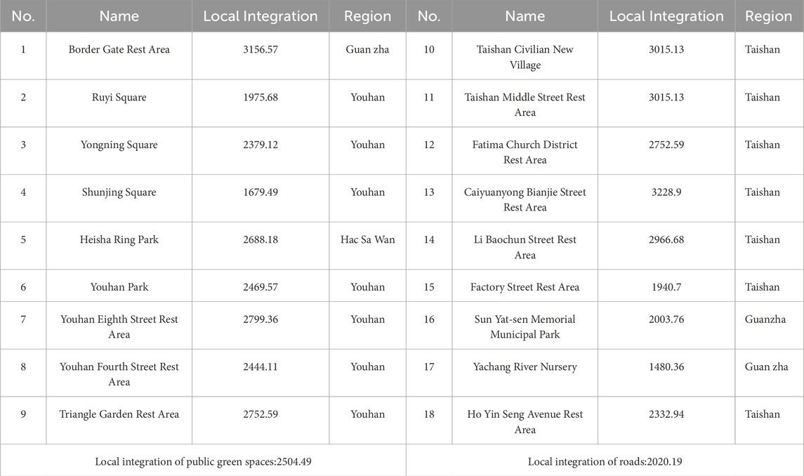
Table 3. Local integration of green spaces in Youhan and Taishan.
3.3.3 Perceived accessibility analysis
The rating of perceived accessibility of public green spaces is composed of spatial location factors, transportation factors, and individual psychological factors. This study quantifies the collaborative degree of the research object through spatial syntax and verifies the true level of the perceived accessibility score of public green spaces using selection degree.
Collaboration degree refers to the degree to which community residents perceive the overall spatial information through local spaces. If a certain space has high perceived accessibility, it is easier to feel the overall space in a small space, which can guide community residents to quickly perceive the public green spaces in the surrounding space in a small space. The degree of choice represents the probability of a node appearing on the shortest path. The higher the degree of choice, the better the traffic elements in the area, and the more people appear. That is, streets with a higher degree of choice are often more attractive to community residents.
This study uses synergy as a variable indicator to analyze the perceived accessibility level of public green spaces in Youhan and Taishan communities. Synergy refers to the overall accessibility of the streets within the study area compared to the local accessibility of the streets (Wolanski, 2023). The calculation follows as Equation 2:
This formula, when combined with SPSS for Pearson correlation testing, aims to verify whether the “macrostructure” and “microstructure” of urban space are coordinated. If
The advantage of Pearson correlation lies in its ability to “quantify the strength of association,” making the abstract concept of “spatial structure coordination” calculable. However, its limitation also stems from its “linear assumption”: the relationship between global and local integration may be nonlinear (for example, “when global integration is medium, local integration exhibits a curved relationship with radius”), while correlation can only capture linear trends, potentially missing complex patterns.
A value of
In this study, Figure 5 shows that when the parameter was set to n = 200, the synergy value of the street axis in the Youhan and Taishan communities of Macau was 0.931818 (>0.7), indicating that the spatial synergy level within the entire research scope was extremely high, and it could identify and control urban large spaces from local spaces. Figure 6 shows that when the parameter was set to n = 400, the synergy value of the street axis within the entire research scope was 0.99, which was higher than the synergy level when n = 200, indicating that the overall spatial structure of Youhan and Taishan communities is more reasonable than that of local spaces.
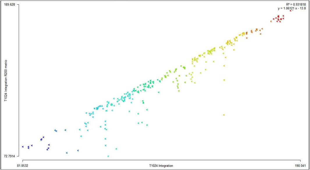
Figure 5. n = 200 synergy level.
Figure 6. n = 400 synergy level.
In Table 4, the global accessibility score and local accessibility score of each public green space in the above study were summarized and imported into SPSS for correlation analysis. The results scored 0.875 (greater than 0.8), indicating a highly correlated relationship. Then the synergy scores of the 18 public green spaces were calculated. If the synergy score of the public green spaces is greater than 0.7, it indicates that the road structure of the public green spaces is clear and easy to recognize, and the level of perceived accessibility is high; if it is lower than 0.7, it indicates that the score is low, indicating that the space around the public green spaces is chaotic, and the perceived accessibility is low.
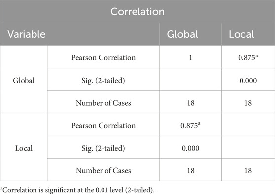
Table 4. Correlation analysis chart.
Sorting out the synergy scores of public green spaces in Youhan and Taishan communities, as shown in Table 5, reveals that the average synergy score of public green spaces is 1.42434, which is higher than the average street synergy score of 0.93182 in Youhan and Taishan communities. This indicates that the layout of public green spaces in the Youhan and Taishan communities has a relatively high level of perceived accessibility within the overall community space. The maximum synergy score of public green spaces is 1.83397 in the Caiyuanyong Bianjie Street Rest Area and 1.04591 in the Yachang River Nursery, which differ greatly, indicating that some local spatial conditions of public green spaces need to be improved.
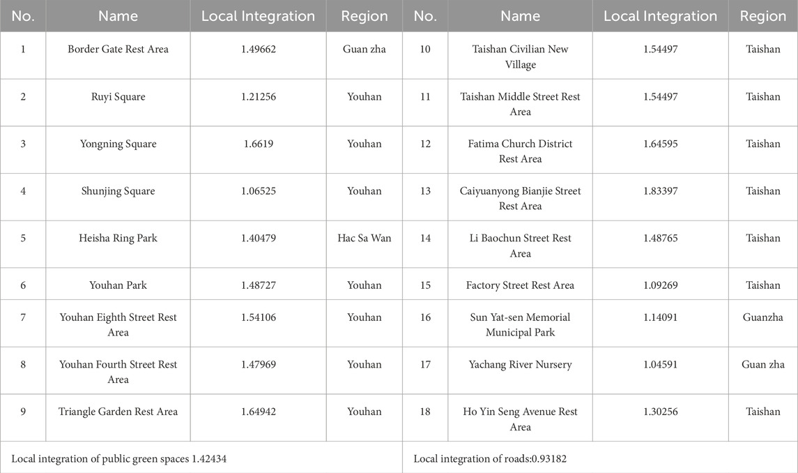
Table 5. Synergy values of green spaces in Youhan and Taishan.
The degree of selection reflects the probability of nodes appearing on the shortest path. Areas with a high degree of selection usually have a larger flow of people, meaning that streets with a high degree of selection are more attractive to community residents. Public green spaces located on such streets are also more attractive (Ratanawichit et al., 2025). An analysis of the perceived accessibility barriers caused by elevated bridges and dead-end roads in Macau revealed that, although the Sun Yat-sen Memorial Municipal Park has a high degree of overall integration, residents can quickly identify and reach it due to the obstruction of the elevated bridge.
The first step in the degree of choice analysis is to set the parameters. This study used a tracking survey based on the establishment of the three walking parameters of 300 m, 600 m, and 1200 m (Li, 2017). These parameters evaluate the efficiency of green space services for different usage scenarios of Macau residents: 300 m (for daily grocery shopping and rest), 600 m (for evening walks), and 1200 m (for weekend leisure). Then, whether the green space covers high-frequency usage paths is evaluated. The selectivity of Youhan and Taishan neighborhood streets under different parameters is obtained through the Depthmap operation and is shown in Figure 7. The spatial syntax operation follows Huang Z et al. (2024). The calculation follows as Equation 3:
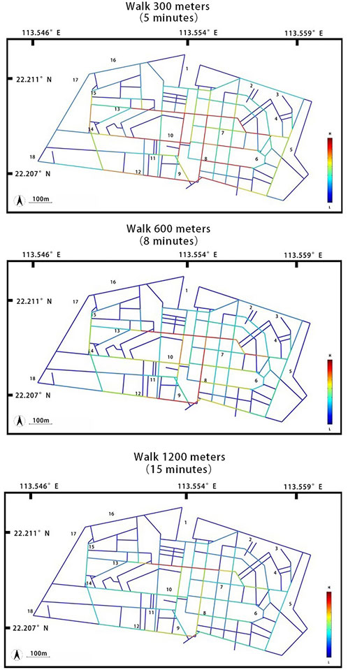
Figure 7. The axis map of the walking 300 m/600 m/1200 m selectivity of green spaces in Youhan and Taishan.
Choice is a core indicator of space syntax, used to identify “flow-controlled streets” and assist in the planning of arterial roads and public space layouts. Nodes with high choice tend to be areas of traffic congestion and commercial activity, supporting facility layout decisions.
In the formula, the numerator refers to traversing all node pairs (j, k) that do not include
The essence of this formula is “the proportion of shortest paths passing through i in the global shortest paths:” By calculating the “proportion of shortest paths that pass through nodes,” the global control ability of nodes in the spatial network is quantified, making it a key tool for urban spatial structure analysis. That is, the higher the ratio, the more nodes’ shortest paths must pass through (
When the parameter is n = 300 (5 min), the most selected roads are Caiyuan Yongbian Street, Stand Street, Guanzha Road, Yongding Street, Libaochun Street, Youhan Fourth Street, Market Street, and Qingzhou New Road. The public green spaces located here include Taishan Civilian New Village Rest Area, Youhan Fourth Street Rest Area, Youhan Park, Caiyuan Yongbian Street Rest Area, Triangle Garden Rest Area, Huadi Ma Church Rest Area, and Yongning Square.
When the parameter is n = 600 (8 min), the most selected roads are Caiyuan Yongbian Street, Zhongxi Section of Stand Street, Guanzha Road, and Yongding Street. The public green spaces located here include the Caiyuan Yongbian Street Rest Area, Youhan Fourth Street Rest Area, Yongning Square, and Triangle Garden Rest Area.
When the parameter is n = 1200 (15 min), the roads with the highest selectivity are Caiyuan Yongbian Street and the west section of Stand Street. The public green spaces located here are the resting area of Caiyuan Yongbian Street and the Triangle Garden Rest Area.
Caiyuanyong Street has the highest frequency of selection, and the frequency of selecting public green spaces located here is also higher. In terms of synergy score, Caiyuanyong Street’s recreational area also performs the highest. In contrast, the Yachang River Nursery has never shown any performance in terms of selectivity data, and its synergy score is also the lowest.
4 Results
Through the analysis of global, local, and perceived three-dimensional accessibility in the previous text, the “potential advantages” and “core shortcomings” of public green spaces in Youhan and Taishan communities in Macau in serving the needs of all age groups were revealed. The results are in clear agreement with the four core goals of the World Health Organization (WHO) for all age-friendly communities (promoting active aging, safeguarding the development of children and adolescents, enhancing intergenerational integration, and improving community resilience), providing a targeted basis for optimizing strategies based on age-inclusive design in the future.
The average global integration degree of public green spaces (1976) is 22.9% higher than that of street networks (1607.97). Table 2 shows that 83% of green spaces have better accessibility than the street average level, indicating that most green spaces have the basic conditions to serve all age groups. High-accessibility green spaces can cover the daily leisure needs of older people and the nearby play needs of children in the core area of the community, which is in line with the goals of “active aging” and “safe growth of children.” However, the global integration degree difference reached 1636.32 (with the highest being 2770.4 and the lowest being 1134.08), exposing significant fairness shortcomings: high-accessibility green spaces are crowded during peak hours due to the “only supply,” conflicts between children’s play and rest spaces for older people, and violate the requirement of “space sharing without conflict” in intergenerational integration. The low-accessibility green space serves older people living alone, groups, and new immigrant families on the northern edge of Youhan community, but due to poor connectivity and single functionality, it cannot meet the needs of older people for “short distance walking and leisure” and children for “natural exploration” and is disconnected from the goals of “health support” and “safe activity space” in “active aging” and “child development.”
The core reason for the difference in global integration is related to the characteristics of the site. The reason why Caiyuanyong Border Street Rest Area (2770.4) has become the most accessible green space in the world is that it is located in the core commuting corridor of “Youhan Market and Taishan Residential Area.” Within 300 m, there are multiple bus stops and supermarkets, which are high-frequency paths for residents’ daily shopping and commuting. The topological distance is short, and there are many connecting nodes. The overall integration degree of Yachonghe Nursery (1134.08) is the lowest, due to its location on the northern edge of the Youhan community, adjacent to the dead-end road, surrounded by mainly old residential areas. Residents must take detours to reach it, resulting in a significant increase in topological distance.
The average local integration degree of public green spaces (2504.49) is 23.9% higher than that of the street network (2020.19), and 72% of green spaces have excellent local accessibility (Table 3), proving that most green spaces (such as Heisha Ring Park and Youhan Eighth Street Rest Area) have the potential to become “all-age activity centers.” Partial high accessibility can reduce the short-distance travel distance for older people and children, adapt to the needs of older people’s “15 min leisure circle” and children’s “nearby play,” and provide a spatial foundation for “intergenerational interaction.” However, connectivity barriers and inadequate functional adaptation have weakened this potential. There is a lack of pedestrian crossings between Heisha Ring Park (with a partial integration degree of 2688.18) and the core node of residents’ daily life (Youhan Market), and older people must detour more than 300 m to enter, which consumes a lot of physical energy. If children are picked up and dropped off by older people, they face the risk of mixed traffic during the detour, which violates the requirement of “safe walking” in the “transportation system” for all ages. Although the accessibility of green spaces such as Ruyi Square (partial integration degree 1975.68) and Shunjing Square (partial integration degree 1679.49) is moderate in some areas, they are only equipped with a single children’s facility or basic seat, without an elderly fitness area or parental care space, and cannot support the “intergenerational coexistence” scenario, which is inconsistent with the goal of “functional composite for all ages” in the dimension of “health support.”
The spatial and social logic of differences in local integration degree. The Caiyuanyong Boundary Street Rest Area (3228.9), which has the highest degree of local integration, can simultaneously serve the leisure needs of children going to school, older people seeking medical treatment, and residents buying groceries, becoming a local activity center. Although the overall integration degree of Taishan Civilian New Village Rest Area (3015.13) is moderate (2154.75), its local accessibility is high. Due to the large number of residential buildings around it, there is a strong demand for “short distance walking rest,” making it one of the most popular green spaces in the area. In contrast, the local integration degree of the Yachong River Nursery (1480.36) is low, mainly due to its isolation by elevated bridges and the lack of surrounding residential buildings, which cannot form a local activity network. Field observations have found that residents around the green space must walk for 8–10 min to reach it, far exceeding the comfort threshold of the “5-min walking circle,” resulting in suppressed local usage demand.
As shown in Table 5, the average synergy coefficient of public green spaces (1.42434) is 52.9% higher than that of the street network (0.93182), indicating good overall perceived accessibility. This means that the “local and global spatial logic” of most green spaces (such as Yongning Square and Triangle Garden Rest Area) is consistent, and older people and children can quickly identify the location of green spaces through surrounding streets, reducing the risk of getting lost and meeting the requirements of “inclusive space identification” in “community resilience.”
The specific meaning and site correlation of the synergy coefficient and correlation results. First, the collaborative value of the street network is 0.9318 when n = 200 and 0.99 when n = 400, indicating that the overall road network of Youhan and Taishan communities presents a “clear hierarchical grid structure.” The connectivity between local streets and the global road network is highly consistent, and residents can quickly perceive the overall space through local paths. This is closely related to the historical pattern of “narrow streets and dense network” in the old town of Macau. Second, the average synergy coefficient of public green spaces is 1.42434, which is higher than that of streets (0.93182), indicating that green spaces are generally easier for residents to identify. However, the synergy coefficient of areas such as Sun Yat-sen Memorial Municipal Park and Yachong River Nursery is relatively low. The core reason is that physical barriers break the “macro–micro coordination:” the entrance of Sun Yat-sen Memorial Municipal Park is blocked by elevated bridge piers, and residents cannot directly see the entrance of green spaces from the main road (globally accessible), so they need to detour to identify them. The Yachong River Nursery is isolated by a dead-end road, and local paths cannot connect to the global road network. Even if residents know its location, they must make multiple turns to reach it, which increases the difficulty of perception. This results in a violation of the goal of “information accessibility” in “inclusiveness,” further widening the gap in usage among different groups, and weakening the resilience of communities to cope with “diverse population structures.”
The usage scenarios and site logic for differences in selection degree. Under the parameter of 300 m (5-min walk), Caiyuanyong Boundary Street has the highest degree of choice, as it is located on the high-frequency path of Youhan Market and surrounding residential areas for residents to buy vegetables and go home, and residents have a strong demand for rest along the way. Under the 600 m parameter (8-min walk), the streets with high selectivity are extended to the central and western sections of Stand Street, corresponding to the scene of residents taking a walk after dinner. At this time, the utilization rate of Yongning Square (synergy coefficient 1.6619) increases because it is close to multiple catering shops, and families can stop here after taking a walk. Under the 1200 m parameter (15 min walk), only the boundary street of Caiyuan Creek and the western section of Stand Street have a high degree of selection, corresponding to the “weekend leisure” scene. The Triangle Garden Rest Area (with a partial integration degree of 2752.59) has become the first choice for parent–child families to relax after reading on weekends due to its proximity to the community library, with a usage rate twice as high as on weekdays. However, the selection degree of Yachonghe Nursery is low under all parameters. In addition to road network defects, it also lacks leisure facilities (only 10 simple benches), which cannot meet the usage needs of different scenarios, further reducing its probability of being included in the shortest path.
As a typical case of high-density urban communities, the Youhan and Taishan communities in Macau have basic conditions for serving all age groups in their public green spaces. However, the three major problems of “uneven global distribution, insufficient local connectivity, and prominent perception barriers” have led to significant shortcomings in achieving age-friendly goals such as “active aging support, child safety protection, intergenerational space sharing, and inclusion of vulnerable groups.” The quantitative analysis results through syntax can provide accurate data support for subsequent age-oriented optimization strategies. This study combines spatial accessibility analysis with the WHO Age-friendly Framework and Age-friendly Design Principles to propose solutions, providing a preliminary quantitative basis for the Macau Municipal Government’s “Overall Planning and Design Guidelines for Public Spaces in Youhan and Taishan Communities,” ensuring that public green spaces truly meet the usage needs of all age groups.
5 Discussion
This study sets three core research objectives: (1) quantifying the spatial accessibility of public green spaces in the ultra-dense Youhan and Taishan communities in Macau; (2) identifying the spatial barriers for residents to access green space services and revealing the mechanism of spatial equity imbalance in green space layout; (3) proposing optimization strategies oriented toward “age-friendly” in combination with the framework of the “Global Age-Friendly Cities” published by the World Health Organization (2007). This section correlates key research findings (derived from spatial syntax analysis and field research) with the above objectives, refining targeted suggestions to enhance the practical value of the research.
5.1 Quantitative and qualitative fit between research results and core objectives: a realistic mapping of spatial equity
The multi-scale spatial syntactic analysis (global, local, perceived accessibility) and field observations not only validate the research hypothesis of “mismatch between green space supply and demand,” but also directly map the core contradiction between the lack of spatial fairness and the imbalance of environmental justice (Lu et al., 2024).
Regarding the first objective (quantifying accessibility and matching degree), the results show that although the average global integration degree of public green spaces (1976) is 22.9% higher than that of street networks (1607.97), and 15 of 18 green spaces (83%) have integration degrees higher than the street average level, the regional differences are significant (the global integration degree range is 1134.08–2770.4). This indicates that the overall accessibility of public green spaces is usually better than the surrounding roads, but their distribution is uneven and cannot match the population demand of high-density communities. For example, the resting area of Caiyuanchong Boundary Street (with a global integration degree of 2770.4, the highest among all green spaces) is located in a high flow street but is the only public green space within the corridor street, resulting in overcrowding during peak hours; On the other hand, the Yachong River Nursery (with a global integration degree of 1134.08, the lowest among all green spaces) covers the northern edge of Youhan community, but due to poor connectivity (adjacent to a dead-end road) and single functionality (only equipped with garden sightseeing facilities), it has been underutilized for a long time. This mismatch phenomenon is essentially a manifestation of the unequal distribution of spatial resources. From the perspective of environmental justice, in the northern edge area of Youhan served by the Yachong River Nursery, a relatively high proportion of the population is older. This group has more urgent demands for “short distance and barrier-free access” due to their limited mobility, but the nursery is adjacent to a dead-end road, forming an environmental injustice pattern of “the most urgent demand area but the worst resources.” The Caiyuanyong Border Street Rest Area is located in the core area of Taishan Community’s residential living area. Although it has excellent accessibility, its area is small and cannot meet the synchronous use of multiple age groups, resulting in a lack of spatial fairness in the “resource concentration area but insufficient carrying capacity” (Chen et al., 2024).
Regarding the second objective (identifying spatial barriers and equity mechanisms), the analysis of local accessibility and perceived accessibility reveals the “differentiated exclusion” effect of environmental justice: the average local integration degree of public green spaces (2504.49) is 23.9% higher than that of streets, but the Heisha Ring Park (2688.18) lacks pedestrian crossings, requiring older residents to detour 200 m to enter. For older people with a walking speed of only 0.8 m/s, this means an additional 5 min of walking time, far exceeding the comfort threshold of the “5-min walking circle,” forming “age exclusion caused by physical barriers.” The Sun Yat-sen Memorial Municipal Park (synergy coefficient 1.14091) is further exacerbated by “perceived barriers leading to usage rejection” due to the elevated bridge blocking the entrance. This “double exclusion” is a typical manifestation of the criticism of the “deprivation of the right to access resources for vulnerable groups” according to environmental justice theory (Mizan et al., 2025).
The three-dimensional optimization framework of “space, service, and policy,” constructed based on specific research results for the third goal (proposing a whole age-oriented strategy), which precisely aligns with the eight dimensions of the World Health Organization, is a practical response to spatial equity and environmental justice. For example, optimization strategies for accessibility barriers (such as adding barrier-free pedestrian crossings) correspond to the “transportation system” dimension, while optimization measures for functional homogenization (such as adding intergenerational activity facilities) correspond to the “health support” dimension, ensuring that the strategy is not an abstract concept, but a solution rooted in empirical problems.
5.2 Typical issues: the deep connection between phenomena and age-friendly fairness
The three typical issues identified in the study (accessibility disparities, mismatch between road networks and green spaces, and insufficient functionality) do not exist in isolation but are closely related to the two core goals of “age-friendly” and “spatial equity” (Heo and Bell, 2022). An analysis of the underlying connections can not only avoid redundant descriptions of research results but also highlight the urgency of optimization:
Accessibility disparities exacerbate the equity gap between groups. The difference between the highest and lowest global integration values is 1636.32, which not only reflects uneven spatial distribution but also indicates equity issues between groups. Youhan Park (global integration 2074.1, local integration 2469.57) is adjacent to Youhan Market, with complete facilities, but it is “marginalized” by residents. Residents in the old area prefer the nearby Youhan Fourth Street Rest Area (local integration 2444.11), while residents in the new area prefer the larger Heisha Ring Park. The root cause of this “dual marginalization” lies in the lack of adaptive facilities for new immigrants (multilingual signs) and older groups (sunshade seats) in the park, which cannot meet the needs of all ages. On the other hand, the Caiyuanyong Bianjie Street Rest Area (synergy coefficient 1.83397, the highest among all green spaces) has excellent accessibility but only covers an area of 500 square meters (meeting the minimum standard for MG12 urban gardens), which cannot accommodate intergenerational activities, leading to spatial conflicts between children playing and older people resting. This phenomenon proves that pure “high accessibility” cannot guarantee equity and must be combined with “all-age functionality” to avoid excluding specific groups.
Road network. Green space mismatch leads to the waste of high-quality resources. Highly accessible streets (such as Caiyuanyong Boundary Street) have scarce green spaces, while low-accessibility areas have multiple high-quality green spaces. This mismatch results in severe resource waste. Heisha Ring Park (local integration degree 2688.18, perceived accessibility 1.40479) has a high vegetation coverage rate and disaster prevention function, but only one entrance/exit is provided, and field investigations found that its user count is relatively low. The He Xianshen Grand Road Rest Area (global integration degree 1739.26) efficiently utilizes scarce land under the viaduct, but due to the impact of bridge noise and exhaust pollution, its service radius is only 300 m. This mismatch not only violates the requirements of the World Health Organization’s “outdoor space” dimension but also reduces the efficiency of green space use, highlighting the importance of simultaneously promoting the optimization of road network-green space connectivity and protecting green space quality (Soriano-Gonzalez et al., 2023).
Insufficient functionality cannot meet the needs of all ages. The issue of some green spaces having a single function directly contradicts the goal of being “age-friendly.” Ruyi Square (with a global integration degree of 1425.94, lower than the average level of green spaces) only has children’s slides, lacking parent-care seating and resting facilities for older people, resulting in a decrease in usage after 18:00 (when children return home). Yongning Square (with a perceived accessibility of 1.6619, higher than the average level of green spaces) is divided into four street center islands, which, despite having complete facilities, suffer from poor spatial continuity, making it difficult to meet the needs of family group activities. The rest area in Huadima Tang District (with a global integration degree of 2254.98) is adjacent to a primary school, but it only has a small lawn and is unable to provide shaded space for parents waiting for students and older people picking up their children. These functional defects indicate that the planning of green spaces in high-density communities must shift from “having green spaces” to “meeting the diverse needs of all ages.” Otherwise, even if the accessibility is excellent, the social service value of green spaces cannot be fully realized.
5.3 Age-friendly optimization strategies and their implications for high-density cities
The optimization strategy proposed based on accessibility analysis can be further deeply linked with the four core goals of “promoting active aging, safeguarding the development of children and adolescents, enhancing intergenerational integration, and improving community resilience” in the WHO’s “Global Guidelines for Age Friendly Cities” (2007). This not only strengthens the theoretical basis of the strategy but also more clearly reflects the practical orientation of “full age coverage.” At the same time, it also provides replicable insights for high-density cities such as Hong Kong and Singapore that are also facing land scarcity issues.
The space-friendly strategy focuses on the issue of “mismatch between road network and green space,” corresponding to the dimension of “outdoor space and transportation system” of the WHO. Through optimizing spatial connectivity and perceptual services, the four core goals are to promote active aging, add barrier-free pedestrian crossings to connect the Youhan Street market and surrounding residential areas in Heisha Ring Park, widen entrances and exits, shorten the travel time of older residents for daily procurement and green space leisure, and ensure their right to use green space. To ensure the development of children and adolescents, colored anti-skid trails will be added to the connecting paths between green spaces, schools, and community centers (such as around the Yachong River Nursery). The speed limit for motor vehicles will be reduced to ≤30 km/h and isolated with green plants. “Children’s Green Space Navigation Signs” will also be marked on the 300 m walking circle to provide a safe environment and reduce the risk of getting lost. Intergenerational integration will be enhanced by connecting the four dispersed central islands of Yongning Square through continuous pedestrian corridors and setting up shared recreational platforms. At the same time, embedding “intergenerational interaction signs” in the connecting paths will break down spatial barriers among age groups and promote intergenerational interaction. To enhance community resilience, in response to the demographic characteristics of Macau, the green space signage system will integrate Chinese, Portuguese, and English languages and add barrier-free facilities to help new immigrants integrate and serve disabled groups, enhancing community inclusiveness and resilience to social structural changes.
The service-friendly strategy addresses the issue of “single green space function” and corresponds to the dimensions of “health support and social participation” of the WHO. Through functional upgrades, the green space is transformed into a “demand response carrier” for all age groups, accurately implementing four core goals: promoting active aging, such as transforming some plant cultivation areas in the Yachonghe Nursery into high-level horticultural areas in the community to achieve healthy exercise and communication, adding an “elderly fitness corner” at Ruyi Square at a reasonable distance from the children’s activity area, taking into account the care of grandchildren and self-health management of older people. To ensure the development of children and adolescents, a children’s activity area (3–6 year old soft climbing facilities, 7–12 year old natural exploration sand pit) and parental care seats will be set up in Ruyi Square. Intergenerational integration will be enhanced by installing “intergenerational shared seats” in Yongning Square to break down age barriers. Community resilience will be enhanced by transforming the temporary recreational area of Caiyuanyong Border Street into a “multifunctional modular space” to meet the needs of different groups at different times. Emergency functional interfaces will also be reserved in green spaces (such as the Black Sand Ring Park sunshade corridor, which can be used as a temporary shelter waiting area) to enhance the community’s ability to respond to risks.
The policy-friendly strategy addresses the issue of “insufficient participation of vulnerable groups” and corresponds to the WHO’s dimension of “inclusivity and citizen participation.” Through institutional design, four core goals are implemented: promoting active aging, clarifying the proportion of older representatives in the “Green Advisory Committee,” and absorbing experienced older people, while incorporating their green space needs into the priority evaluation of Macau’s “Community Micro Renewal Plan.” The development of children and adolescents can be ensured by setting up a “Children’s Green Space Suggestion Box” and having teacher representatives organize feedback. A section can be reserved for children’s participation in green space renovation. To enhance intergenerational integration, an “intergenerational coordination group” can be established in the advisory committee to review relevant plans and include the “intergenerational integration effect” in the renovation acceptance indicators. To enhance community resilience, a green space demand priority evaluation system can be established with “coverage of vulnerable groups” as the core in the “Community Micro Renewal Plan,” clarifying the dynamic adjustment mechanism of green space functions (Marvin et al., 2019).
By integrating the three strategies of “space-friendly, service-friendly, and policy support” into these eight dimensions, we can not only propose directions for improvement for the specific issues of high-density communities in Macau but also align them with the standards of international elderly-friendly communities, thereby enhancing the comparability of cross-city promotion.
6 Conclusion
This study employs the theory of space syntax to quantitatively analyze the global accessibility, local accessibility, and perceived accessibility of 18 public green spaces in the Youhan and Taishan communities in Macau. Utilizing AutoCAD and Depthmap Beta 1.0 software, we calculated core indicators such as integration degree, synergy coefficient, and selection degree, revealing the spatial mismatch characteristics of public green spaces in high-density environments and providing empirical evidence for targeted optimization.
The overall accessibility of public green spaces surpasses that of the surrounding street networks, with significant spatial disparities. The average global integration value of the street networks is 1,607.97, whereas that of the public green spaces reaches 1,976, representing an improvement of 22.9%. Out of 18 green spaces, 15 (accounting for 83%) exceed the average value of the street networks. This indicates that public green spaces are generally more accessible than other infrastructures on adjacent roads. However, the global integration values of individual green spaces vary greatly, ranging from 1,134.08 for the Yachang River Nursery to 2,770.4 for the Cai Yuanpei Boundary Street Rest Area, which is a difference of 1,636.32. This disparity leads to actual underutilization. For instance, the Yachang River Nursery, due to its limited functionality and poor connection to the pedestrian network, cannot meet residents’ needs. Conversely, high-accessibility streets like Cai Yuanpei Boundary Street lack sufficient green space coverage, making it difficult to cope with concentrated pedestrian flow.
The layout of public green spaces clearly does not match the street accessibility patterns. The spatial overlay analysis of green space distribution and street global integration maps reveals that high-accessibility streets (such as Cai Yuanpei Boundary Street and Li Baochun Street) experience a 40% higher pedestrian flow during peak hours (inferred from the selection degree analysis of 300-m walking parameters) compared to the average level, yet only 2 of 18 public green spaces are located on these streets. Conversely, low-accessibility areas (such as the northern edge of the Youhan community) are home to six high-quality green spaces (such as Hesha Ring Park, with a local integration value of 2,688.18, which is 32.1% higher than the average value of the street network), but they are underutilized due to road connectivity defects (such as the lack of pedestrian crossings and dead-end roads). Functional defects further exacerbate this mismatch. For example, Yiyi Square (global integration value of 1,425.94, lower than the average value of green spaces) only has children’s play facilities and lacks seating for older residents to rest. Yongning Square (perceived accessibility of 1.6619, higher than the average value) is fragmented due to spanning multiple street medians, limiting intergenerational interaction.
The optimization strategy aligns with the World Health Organization’s “Globally Friendly Cities” initiative, aiming to address challenges specific to certain locations. The “Space-Friendly” strategy addresses transportation mismatches, such as recommending the installation of barrier-free pedestrian crossings near the Black Sand Ring Park to enhance pedestrian connectivity and barrier-free design, which is expected to increase park usage. The “Service-Friendly” strategy addresses the issue of limited functionality, transforming the Yachang River Nursery from a mere plant cultivation base into an ecological leisure space equipped with sunshade pavilions and intergenerational activity areas, thereby broadening the user base. The “Policy Support” strategy addresses the underrepresentation of vulnerable groups, establishing a community advisory committee comprised of new immigrants, low-income older people, and disabled individuals to participate in decision-making regarding green space renovation.
6.1 Limitations of the study
This study also has certain limitations, and its universality and practical application require critical examination.
(1) Insufficient sample representativeness. The 18 public green spaces analyzed are solely from the Youhan and Taishan communities, failing to encompass other high-density areas in Macau, such as the Old Taipa area, and mixed commercial and residential land. This scope does not reflect the diversity of green space types (MG11 urban parks, MG12 urban gardens, and MG13 country parks) defined by the IAM. For instance, the MG12 urban gardens in the Xingang area, despite being compact, are integrated with commercial complexes, which significantly differ from the community-level green spaces that this study focuses on. Consequently, the research conclusions cannot be generalized to the broader high-density urban system of Macau.
(2) Over-reliance on static objective data. The study primarily utilizes static road and green space data for 2022 provided by IAM, neglecting dynamic factors that affect green space usage and subjective accessibility perception. In terms of temporal dynamics and seasonal and meteorological impacts, the Youhan community experiences a significant influx of daytime population due to commuting, but static accessibility analysis fails to capture the surge in demand during peak periods such as lunch breaks and evening leisure time. Macau has a subtropical marine monsoon climate, with high temperatures in summer and frequent impacts from typhoons and rainstorms, but this factor is not incorporated into the accessibility assessment for open spaces like the Triangle Garden Rest Area.
6.2 Mitigation strategies for limitations
To address the aforementioned limitations and enhance the theoretical rigor and practical value of the research, the following targeted mitigation strategies are proposed:
To address the issue of insufficient sample representativeness, the sample will be expanded to 40–50 public green spaces in multiple high-density communities in Macau (including Iao Hon, Taipa, Xingang, Chopsticks Base, and Old Taipa), and stratified analysis will be conducted based on IAM green space types (MG11/MG12/MG13). This will facilitate the comparison of accessibility patterns under different land use backgrounds (mainly residential and mixed-use) and green space sizes, enhancing the applicability of the research results across the entire region. Simultaneously, systematic random sampling will be employed to ensure representative coverage of high-density communities in Macau and to avoid selection bias in green space sampling.
To address the issue of over-reliance on static data, multi-source dynamic data will be integrated to deepen analysis: (1) Mobile signaling data from the Macau Telecommunications Bureau will be used to map pedestrian flow within a 15-min walking circle during three time periods (7:00–9:00 a.m., 12:00–2:00 p.m., and 6:00–8:00 p.m.) for time-sensitive accessibility assessment; (2) Historical meteorological data (temperature, rainfall, wind speed) from the Macau Meteorological and Geophysical Bureau spanning 5 years will be incorporated to simulate seasonal changes in accessibility and adjust indicator weights (such as increasing the weight of shading facilities in summer); (3) A mixed-method study will be conducted, involving questionnaire surveys of 300 residents (stratified by age, income, and immigration status) and semi-structured interviews with 30 key stakeholders (such as older residents, parents, and community managers), to calibrate objective accessibility indicators with subjective perceptions, refine the calculation of synergy coefficients, and incorporate user-specific factors, such as mobility impairments.
6.3 Concluding comments
This study systematically reviewed and clarified the limitations of the research, quantified the spatial mismatch characteristics between public green spaces and population needs based on a precise spatial syntactic indicator system, and further integrated green space optimization strategies with the WHO International Framework for Age-Friendly Cities. Ultimately, a structured and internationally benchmarked reference framework was constructed for the optimization practice of age-friendly public green spaces in Macau and similar high-density cities. The research conclusions and limitation coping strategies not only strengthen the theoretical rigor of the study but also provide practical and feasible implementation paths for the urban planning department of Macau, directly supporting the overall planning and design guidelines of the public spaces in the Yuhan and Taishan communities of the Macau Municipal Government.
Future research will focus on the long-term use efficiency of public green spaces after renovation through dynamic tracking and research of crowds and monitoring the changes in pedestrian flow and usage characteristics of green spaces after the implementation of optimization measures, such as adding barrier-free pedestrian crossings. At the same time, combined with structured questionnaire surveys, we will conduct in-depth evaluations of the fairness level of public green space services, ultimately providing objective and effective practical guidance for further improving the public green space planning system in high-density urban environments and promoting the construction of age-friendly cities.
Data availability statement
The datasets presented in this study can be found in online repositories. The names of the repository/repositories and accession number(s) can be found in the article/supplementary material.
Ethics statement
Ethical approval was not required for the study involving humans in accordance with the local legislation and institutional requirements. Written informed consent to participate in this study was not required from the participants or the participants' legal guardians/next of kin in accordance with the national legislation and the institutional requirements.
Author contributions
YW: Visualization, Formal Analysis, Software, Data curation, Writing – review and editing, Conceptualization, Investigation, Writing – original draft. PW: Writing – review and editing, Methodology, Validation, Project administration, Data curation, Supervision, Conceptualization, Visualization. JZ: Software, Conceptualization, Visualization, Investigation, Funding acquisition, Writing – original draft, Resources, Writing – review and editing, Methodology, Validation, Project administration, Data curation.
Funding
The author(s) declare that financial support was received for the research and/or publication of this article. This research was funded by 1) Key Project of the Ministry of Education’s Special Project for Outstanding Traditional Chinese Culture (Category A): “Interweaving and Symbiosis: A Study on Architectural Decoration in the Historic Centre of Macao” (Project of the Nishan World Center for Confucian Studies/China Confucius Foundation (23JDTCA010). 2) Guangdong Province Philosophy and Social Sciences Planning Project: “Innovative Application Research on Decorative Patterns of Macao’s Historic Buildings from the Perspective of Artificial Intelligence (AI)” (Lingnan Culture Project of the Guangdong Provincial Philosophy and Social Sciences Planning Leading Group Office (GD25LN32). 3) 2024 Guangdong Provincial Higher Education Innovation Team Project (Social Sciences) Platform and Project: “Cultural Heritage and Intelligent Design Innovation Team” (2024WCXTD029). 4) Research Capacity Enhancement Project for the 2022 Doctoral Program Construction Units at Guangdong Polytechnic Normal University (22GPNUZDJS59 and 22GPNUZDJS58). 5) 2020 Provincial First-Class Undergraduate Program of the Ministry of Education (Environmental Design Major), Provincial First-Class Undergraduate Course “Landscape Design Foundation” (991710368). 6) 2021 University-Level Research Project Talent Special Fund of Guangdong Polytechnic Normal University—Research on the Optimization of Public Green Space Layout in Macao (2021SDKYB058). 7) Guangdong Polytechnic Normal University Scientific Research Start-up Fund (99166990233). 8) Guangdong Polytechnic Normal University Horizontal Research Project—Research and Development of Green, Eco-friendly, and Energy-Saving Landscape Lighting Devices (1747379).
Acknowledgements
This research was assisted by the City University of Macau. We sincerely thank all the institutions and funding bodies involved for their generous contributions to this research.
Conflict of interest
The authors declare that the research was conducted in the absence of any commercial or financial relationships that could be construed as a potential conflict of interest.
Generative AI statement
The author(s) declare that no Generative AI was used in the creation of this manuscript.
Any alternative text (alt text) provided alongside figures in this article has been generated by Frontiers with the support of artificial intelligence and reasonable efforts have been made to ensure accuracy, including review by the authors wherever possible. If you identify any issues, please contact us.
Publisher’s note
All claims expressed in this article are solely those of the authors and do not necessarily represent those of their affiliated organizations, or those of the publisher, the editors and the reviewers. Any product that may be evaluated in this article, or claim that may be made by its manufacturer, is not guaranteed or endorsed by the publisher.
Footnotes
1 Macau Bureau of Statistics https://www.dsec.gov.mo/zh-CN/Statistic?id=1
2 Macau Municipal Governmen thttps://www.dsedj.gov.mo/ijm/stat/pdf/yim_10.pdf
3 Macau Natural ResourcesBureau: www.iam.gov.mo/nature/c/facility/rest; www.iam.gov.mo/nature/c/facility/park
References
Al-Qawasmi, J. (2019). Exploring indicators coverage practices in measuring urban quality of life. Proc. Institution Civ. Eng. - Urban Des. Plan. 172 (1), 26–40. doi:10.1680/jurdp.18.00050
Al-Qawasmi, J. (2020). Measuring quality of life in urban areas: toward an integrated approach. Int. J. Environ. Sci. and Nat. Resour. 25 (2). doi:10.19080/ijesnr.2020.25.556158
Battiston, A., and Schifanella, R. (2024). On the need for a multi-dimensional framework to measure accessibility to urban green. npj Urban Sustain. 4 (1), 10. doi:10.1038/s42949-024-00147-y
Benameur, O., Leghrib, F., and Laroui, A. (2024). Assessing urban green space accessibility for sustainable development in Mostaganem, Algeria: a space syntax approach. J. Contemp. Urban Aff. 8 (1). doi:10.25034/ijcua.2024.v8n1-11
Button, K. (2002). City management and urban environmental indicators. Ecol. Econ. 40 (2), 217–233. doi:10.1016/s0921-8009(01)00255-5
Cetin, M. (2015). Using GIS analysis to assess urban green space in terms of accessibility: case study in Kutahya. Int. J. Sustain. Dev. and World Ecol. 22 (5), 1–5. doi:10.1080/13504509.2015.1061066
Chamaret, A., O'connor, M., and Récoché, G. (2007). Top-Down/bottom-up approach for developing sustainable development indicators for mining. Int. J. Sustain. Dev. 10 (1), 161–174. doi:10.1504/IJSD.2007.014420
Chen, Z., Liu, Q., Li, M., and Xu, D. (2024). A new strategy for planning urban park green spaces by considering their spatial accessibility and distributional equity. Forests 15, 570. doi:10.3390/f15030570
Dawson, P. C. (2002). Space syntax analysis of central Inuit snow houses. J. Anthropol. Archaeol. 21 (4), 464–480. doi:10.1016/s0278-4165(02)00009-0
Delhey, J., Böhnke, P., Habich, R., and Zapf, W. (2002). Quality of life in A European perspective: the euromodule as a new instrument for comparative welfare research. Soc. Indic. Res. 58 (1/3), 161–175. doi:10.1023/a:1015783800462
Duan, J., Yang, T., Sheng, Q., Wang, H., and Dai, X. (2019). Space syntax tutorial. Beijing: China Architecture Building Press.
Farage, M. A., Miller, K. W., Ajayi, F., and Hutchins, D. (2012). Design principles to accommodate older adults. Glob. J. Health Sci. 4 (2), 2–25. doi:10.5539/gjhs.v4n2p2
Flynn, P., Berry, D., and Heintz, T. (2002). Sustainability and quality of life indicators: toward the integration of economic, social and environmental measures. J. Soc. Health 1 (4), 23–36. doi:10.1080/15357449.2002.11069150
Friedman, M. I. (1997). Improving the quality of life: a holistic scientific strategy. Westport: Praeger Press.
Han, J., Chan, E. H. W., Qian, Q. K., and Yung, E. H. K. (2021). Achieving sustainable urban development with an ageing population: an “Age-Friendly City and Community” approach. Sustainability 13 (15), 8614. doi:10.3390/su13158614
Heo, S., and Bell, M. L. (2022). Investigation on urban greenspace in relation to sociodemographic factors and health inequity based on different greenspace metrics in 3 US urban communities. J. Expo. Sci. and Environ. Epidemiol. 33 (2), 218–228. doi:10.1038/s41370-022-00468-z
Hosseini, S. Z., Raofi, R., Hamidkhaniha, S., Daneshgar, F., and Wynn, M. (2025). Green infrastructure for sustainable urban development: a case study from Tehran. Green Low-Carbon Econ. 00 (00), 1–5. doi:10.47852/bonviewglce52025029
Huang, Z., Wang, B., Luo, S., Wang, M., Miao, J., and Jia, Q. (2024). Integrating streetscape images, machine learning, and space syntax to enhance walkability: a case study of seongbuk district, Seoul. Land 13 (10), 1591. doi:10.3390/land13101591
Keyes, L., Rader, C., and Berger, C. (2011). Creating communities: atlanta’s lifelong community initiative. Phys. and Occup. Ther. Geriatrics 29 (1), 59–74. doi:10.3109/02703181.2011.552168
Li, M. (2017). The planning strategies of a 15-minute community life circle based on behaviors of residents. J. Urban Plan. 1 (17), 111–118. doi:10.16361/j.upf.201701014
Li, Y. X., and Xing, Y. L. (2021). Research on the planning and design of public open spaces and facilities in high-density neighbourhoods in Macau. Furnit. Interiors 10, 48–52. doi:10.16771/j.cn43-1247/ts.2021.10.010
Li, M., and Ye, C. D. (2015). Gateway criteria and global distribution characteristics of high-density cities. World Geogr. Res. 1 (8), 38–45. doi:10.3969/j.issn.1004-9479.2015.01.005
Lu, Y., Chen, R., Chen, B., and Wu, J. (2024). Inclusive green environment for all? An investigation of spatial access equity of urban green space and associated socioeconomic drivers in China. Landsc. Urban Plan. 241, 104926. doi:10.1016/j.landurbplan.2023.104926
Marvin, S., Yang, J., Zheng, Y., and Rutherford, J. (2019). Correlation, mechanism, control: research on high-density urban pedestrian suitability environment construction based on micro-climate assessment. Urban Plan. Int. 34 (5), 16–26. doi:10.22217/upi.2019.387
Mizan, R., Neutra, R. R., Cerarols, R., and Pelowski, M. (2025). Operationalising ‘loveability’: an interdisciplinary approach to enriching quality of life experiences in cities through creative cultural spaces. Front. Built Environ. 10, 1504553. doi:10.3389/fbuil.2024.1504553
Oh, K., and Jeong, S. (2007). Assessing the spatial distribution of urban parks using GIS. Landsc. Urban Plan. 82 (1-2), 25–32. doi:10.1016/j.landurbplan.2007.01.014
Ojobo, H., Oluwagbemiga, P. A., and Shamang, K. J. (2024). Unveiling the impact of urban green landscape on quality of life in Kaduna, Nigeria: residents’ perceptions and sustainable strategies. J. Contemp. Urban Aff. 8 (1), 16–36. doi:10.25034/ijcua.2024.v8n1-2
Ratanawichit, P., Arifwidodo, S., and Anambutr, R. (2025). First-mile walking, neighbourhood walkability and physical activity in Bangkok, Thailand. Front. Built Environ. 11, 1470792. doi:10.3389/fbuil.2025.1470792
Sanchez-Sepulveda, M. V., Navarro, J., Amo-Filva, D., Fonseca, D., Antúnez-Anea, F., and Barranco-Albalat, A. (2024). A data-driven approach to enhance urban infrastructure for sustainable mobility and improved quality of life in highly populated cities. Case study: barcelona. Front. Built Environ. 10, 1439700. doi:10.3389/fbuil.2024.1439700
She, M. X., and Tan, Z. J. (2014). Analysis on the characteristics of community park construction in Macau’s high-density urban area. Guangdong Landsc. Archit. 36 (04), 4–9. doi:10.3969/j.issn.1671-2641.2014.04.001
Soriano-Gonzalez, R., Perez-Bernabeu, E., Ahsini, Y., Carracedo, P., Camacho, A., and Juan, A. A. (2023). Analyzing key performance indicators for mobility logistics in smart and sustainable cities: a case study centered on Barcelona. Logistics 7 (4), 75. doi:10.3390/logistics7040075
Subedi, R., Rijal, H. B., Khadka, S., Aqilah, N., and Lamsal, P. (2025). Development of adaptive thermal comfort model for urban park based on field survey and literature review. Front. Built Environ. 10, 1526919. doi:10.3389/fbuil.2024.1526919
Sun, Y., and Luo, S. (2024). A study on the current situation of public service facilities’ layout from the perspective of 15-Minute communities—taking chengdu of Sichuan Province as an example. Land 13 (7), 1110. doi:10.3390/land13071110
Wang, L. (2010). The controlling index system of urban neighbourhood living space planning. Mod. Urban Res. 2 (10), 45–54. doi:10.3969/j.issn.1009-6000.2010.02.009
Wang, J. B., and Chang, H. X. (2021). Research on the ‘scenario-based’ design strategy of age-friendly communities: a case study of the transformation design of old communities in a central city. Shanghai Urban Plan. 000 (001), 38–44. doi:10.11982/j.supr.20210106
Wang, L., and Wang, X. Z. (2011). Principles of community system planning from the perspective of urban living space quality. Mod. Urban Res. 9, 62–71. doi:10.3969/j.issn.1009-6000.2011.09.009
Wang, P., Song, W., Zhou, J., Tan, Y., and Wang, H. (2023). AI-Based environmental color system in achieving sustainable urban development. Systems 11 (3), 135. doi:10.3390/systems11030135
Wolański, M. (2023). The potential role of railway stations and public transport nodes in the development of ’15-minute cities. Infrastructures 8 (10), 141. doi:10.3390/infrastructures8100141
World Health Organization (2007). Global age friendly cities: a guide. Geneva: World Health Organization Press.
Yin, H. W., Kong, F. H., and Zong, Y. G. (2008). Evaluation of urban green space accessibility and equity. J. Ecol. 28 (7), 3375–3383.
Yu, Y., and Jiang, L. (2021). Research on micro-renewal design of public facilities in urban old residential areas. Furnit. Interiors 10 (5), 107–111. doi:10.16771/j.cn43-1247/ts.2021.10.020
Zhou, J., and Wang, P. (2023). Multi-level research of living space with sensors and actuators technology in the historic centre of Macao from the perspective of space syntax. Phys. Chem. Earth Parts A/B/C 132, 103485. doi:10.1016/j.pce.2023.103485
Zhou, J., Wang, P., and Xie, L. (2023). Exploring the interplay between small-scale commerce and traffic flow dynamics in Macao historical districts for sustainable urban development. J. Knowl. Econ. 15 (3), 13919–13945. doi:10.1007/s13132-023-01653-7
Keywords: high-density community, public green spaces, accessibility analysis, all-age friendly, urban equity, Macau
Citation: Wang Y, Wang P and Zhou J (2025) Optimizing the spatial accessibility of public green spaces in high-density communities in Macau under an all-age orientation. Front. Built Environ. 11:1662377. doi: 10.3389/fbuil.2025.1662377
Received: 09 July 2025; Accepted: 06 October 2025;
Published: 19 November 2025.
Edited by:
Shixian Luo, Southwest Jiaotong University, ChinaReviewed by:
Hourakhsh Ahmad Nia, Alanya University, TürkiyeZhili Chen, Nanjing University of Aero, China
Copyright © 2025 Wang, Wang and Zhou. This is an open-access article distributed under the terms of the Creative Commons Attribution License (CC BY). The use, distribution or reproduction in other forums is permitted, provided the original author(s) and the copyright owner(s) are credited and that the original publication in this journal is cited, in accordance with accepted academic practice. No use, distribution or reproduction is permitted which does not comply with these terms.
*Correspondence: Pohsun Wang, cGh3YW5nQGNpdHl1LmVkdS5tbw==; Junling Zhou, dTE3MDkyMTA1MTIxQGNpdHl1Lm1v
† These authors have contributed equally to this work