 Sen Zhang
 Ke Zhang2†
- 1School of Civil Engineering and Architecture, Wuhan University of Technology, Wuhan, China
- 2Department of Built Environment, Eindhoven University of Technology, Eindhoven, Netherlands
- 3School of Architecture, Tianjin University, Tianjin, China
Introduction: Compared with prefecture-level cities and other large cities, county-level cities in China have significant differences in composition of public service facilities, population size characteristics, and social awareness. Thus, it is necessary to conduct refined research on barrier-free design and evaluation in county-level cities.
Methods: We used Xinle as an example based on the composition of vulnerable groups and people’s spatio-temporal activity data from the perspectives of public service facilities, tactile paving systems, and activity areas to explore the construction approach and current situation of barrier-free public activity systems (PAS).
Result: The main vulnerable groups in Xinle those who are the elderly, visually impaired, and mobility-impaired individuals. Among these groups, common needs characteristics can be found in the area of shopping consumption and company and enterprise, non-common characteristics centered around food and beverages, life services, healthcare, and parking lots. Then the spatial distribution of related public service facilities is vital for building barrier-free environments. At the same time, the tactile paving system in Xinle has weak correlation with key facilities and poor construction standards.
Discussion: From this, optimization strategies for a barrier-free PAS is construct in this research and to provide theoretical and technical references for county-level cities to carry out related work.
1 Background
Currently, China has 394 county-level cities. Based on China’s seventh national population census and the local statistical bulletins from 2023, the total population of county-level cities is estimated to be approximately 400 million, accounting for 25%–30% of the country’s total population. However, significant regional differences exist in the quality of urban environmental construction and public service levels among county-level cities in China (Xiong et al., 2018; Wang et al., 2020; Sun et al., 2022). County-level cities in developed regions such as Jiangsu, Zhejiang, and Guangdong have well-developed infrastructure, good environmental governance, and public services that are close to (or even exceed) the level of prefecture-level cities. However, county-level cities in underdeveloped areas face problems, such as lagging infrastructure and insufficient public services (Li et al., 2015; Zhang et al., 2019). Overall, the quality of county-level cities in China is fairly low, with insufficient supervision, refined evaluation and optimization strategy of urban environments, particularly for the construction of barrier-free environments (BFEs) (Sun et al., 2023; Yang et al., 2024; Tan and Chen, 2025). Since the Management Measures for Creating National Demonstration Cities (Counties) for Barrier-free Construction were released in 2022, the barrier-free construction of county-level cities has begun to receive attention. Although the 2023 Law of the People’s Republic of China on the Construction of Barrier-free Environments has effectively promoted the renovation of barrier-free facilities nationwide, enforcement efforts in county-level cities are generally weaker than those in prefecture-level cities (Sun et al., 2023). The construction of BFEs in many city centers and old urban hubs in county-level cities is still in the early stages. Meanwhile, because of comprehensive factors such as uneven resource allocation, economic pressure, traditional beliefs, group discrimination, and social services, the actual living experiences and quality of life of people with disabilities, the elderly, and those with mobility impairments in county-level cities vary greatly (Zhang and Ge, 2017), and their daily activities are complex and challenging (Deng and Zhou, 2022). Exploring a refined evaluation and optimization strategy path for accessible environments that is suitable for county-level cities based on the layout features of urban functional facilities, the daily activity needs of the population, and environmental conditions is of great significance for promoting social equity and inclusiveness in county-level cities (Tang and Dong, 2022). At the same time, conducting research on accessible design strategies from the perspective of county-level cities can supplement the lack of guidance for the construction of accessible environments in county-level cities and further improve the spatial as well as regional allocation systems of accessible facilities in urban and rural parts of China. Thus, we used the city of Xinle in Hebei Province as an example to perform in-depth research on strategies and practical paths for building accessible environments in central urban areas.
2 From evaluation to optimization
Currently, the construction of BFEs has led to the establishment of systematic norms and procedural requirements for developed nations (Dai et al., 2023; Tucker et al., 2023; Zhao et al., 2014). For example, Japan regards accessibility as a holistic system and has refined matching rules between facility configuration and crowd activities through legislation (Deng and Zhang, 2015). In Japan’s urban hierarchy, prefectures are responsible for formulating regional accessibility policies and coordinating accessibility planning across cities, towns, and villages. Meanwhile, cities, towns, and villages focus on refining accessibility requirements according to local regulations, and some places have set stricter standards. In Europe, the Netherlands officially implemented the ‘Omgevingswet’ in 2024, which provides a legal and digital unified platform for all spatial construction, proposes institutional foundations for accessible facilities, and encourages people with disabilities to participate in the research and development of accessible policies at the community level based on the implementation of local inclusive policies at the provincial, administrative, and municipal levels (Henderson-wilson et al., 2022; Van Hoven et al., 2024). The accessibility system in Germany consists of federal laws, administrative regulations, and enforcement mechanisms at the state and municipal levels, comprising a multi-level governance model. The federal level sets basic obligations and technical standards through legislation (such as DIN 18040), and state governments can develop local regulations in accordance with legislation to promote the integration of accessibility principles into land-use planning and urban design processes. Simultaneously, based on this, state governments refine the technical requirements in the regulations for urban construction management, whereas municipalities implement them in actual construction projects (Manley, 1996; Loeschcke and Pourat, 2022). In the US, with federal laws at the core, states, counties, and municipalities refine enforcement through additional regulations, thus forming a multi-level standard system. At the state level, the focus is on implementing the Disability Act, developing state-building codes, and overseeing state-owned facilities. At the county level, requirements are refined through local regulations that focus on managing areas that have not been incorporated into municipalities (including relevant rural zones) to ensure that various public service facilities comply with the Disability Act (Eisenberg et al., 2020; Wen and Zhang, 2020; Tan and Chen, 2025).
China uses the Law of the People’s Republic of China on the Construction of Barrier-free Environments, implemented in 2023, as a guideline to promote the progress of building urban BFEs. However, compared with the international experience, the creation and governing of accessible environments in urban areas at all levels in China generally relies on extensive promotion. The current practice of building BFEs is more traditional in county-level cities, most of which focus on enhancing facility coverage guided by administrative assessment and the quality improvement of single-material facilities (such as tactile paving and pedestrian crossing facilities); county-level cities have not formed a systematic construction model (Chen et al., 2020; Ye and Su, 2021).
In addition, county-level cities in different regions also reflect different construction orientations in the construction of accessible environments. For example, county-level cities in the Yangtze River Delta and Pearl River Delta (such as Kunshan and Yiwu) consider barrier free construction as the key to improving urban quality and soft power. Its practice pays attention to high standard special planning, and integrates the development of smart cities. Its achievements are not only reflected in high-density and high-quality hardware facilities (such as tactile paving and ramps), but also include barrier free electronic maps, government information barrier free refined disability services, realizing the exploration from physical barrier free environment to information barrier free environment (China Press for Persons with Disability, 2025). In contrast, the construction of county-level cities in North China (such as Hebei) is more reflected in “policy driven and key breakthroughs”, with the core goal of responding to higher-level assessments (Wang, 2025). Policy promotion relies on administrative instructions and special rectification. Although there has been a significant improvement in the accessibility rate of key venues, it is limited by funding, traditional concepts, and insufficient supervision in the later stage (Xu, 2015). Overall, there are problems such as systematic deficiencies, low levels of intelligence, and limited social participation. This difference reveals the uneven development of barrier free environments in county-level cities in China: Southeast coastal counties and cities shape modern urban competitiveness and cultural warmth through barrier free construction, while North China counties and cities focus more on completing basic compliance tasks. The two are in stark contrast in terms of construction motivation, technological application, and system integrity.
In addition, owing to the lack of effective higher-level planning and guidance, refined evaluation and optimization, and insufficient integration with the actual situation in the region, lax management mechanisms and outdated design concepts in county-level cities have been exacerbated (Sun et al., 2023). County-level cities face problems such as mismatched planning and demand for accessible facilities, loose regulatory systems, and weak public participation awareness (Deng and Zhou, 2022). Little research has been conducted on the adaptability of barrier-free systems to their own development levels, population structures, and spatial characteristics, and there is still insufficient consideration of the feedback needs of residents, resulting in many county-level cities’ construction of BFEs lagging behind real conditions and people’s needs.
Regarding the latest research findings, existing achievements are primarily grounded in an analysis and evaluation of the activity-related characteristics of disabled people in prefecture-level cities or large and super-large cities (Chen et al., 2020; Hua et al., 2025). Urban spatial features have a significant impact on the travel intentions of disabled and elderly people (Cheng et al., 2019; Chidiac et al., 2024; Wen et al., 2023). Some studies have shown a significant correlation between the activity-related characteristics of people with disabilities and the distribution of urban public service facilities (PSFs) (Shen et al., 2023; Jiang et al., 2025; Zhou et al., 2022). However, in research on county-level cities or cities of a similar scale, qualitative survey methods or static facility statistics rely mainly on basic data (such as people’s life perceptions and activity-related characteristics) through traditional means (such as key person interviews and questionnaire collection) to evaluation the matching relationship between people’s daily travel and various PSFs, public spaces, and other environmental elements (Ravi et al., 2021; Zhang et al., 2021; Chen et al., 2024; Fan et al., 2024). There has been insufficient research on optimization strategy for building accessible environments and clarifying the focus of design elements (Xiang and Wang, 2025). Owing to issues such as information accuracy and sample size, it is difficult to support precise decision-making, and a systematic practical path has not yet been formed.
Through a review of relevant studies on the evaluation and optimization strategy experience and present situation in different countries, we can deduce that research on accessible environments for county-level cities has begun to establish a foundation, and emerging technologies have provided possibilities for building new research paths. However, limitations remain in the governing and building of accessible environments in county-level cities in China—including a lack of effective macro-guidance, inadequate evaluation of spatial adaptability, and an unclear focus on the optimization strategy of accessible environments in urban areas—which hinder the goal of refined construction. The research data and methods at the county level are relatively single, and a correlation analysis of pertinent dimensions (such as urban structure, facility configuration, population travel demand, and activity space in the region) has not yet been established. The spatial coupling mechanism between population activities and environmental factors has not been quantified and cannot effectively guide the development of barrier-free designs and governing. In-sufficient social attention and a lack of humanistic care from citizens and governments in county-level cities have reduced the driving force and quality of BFE construction.
Compared with prefecture-level cities or large or super-large cities, county-level cities have their own features with a moderate urban scale, clear urban and population structures, and a fairly clear allocation of relevant PSFs (Xiang and Wang, 2025). This provides a solid foundation for refining the evaluation and optimization of building an accessible environment. However, there are gaps in existing research on county-level cities, such as small data volumes and insufficient coupling between facilities, paths, and regions. We relied on multi-source spatiotemporal data and a facility weight model to compensate for this circumstance. Learning and simulating data features can provide new research perspectives and methods to address the difficulties in obtaining data on disabled populations and insufficient sample data in county-level cities. Thus, based on the urban structural aspects of county-level cities, combined with the evaluation of people’s spatio-temporal data and facility needs, this study conducted research on an accessible public activity system (PAS) to refine the key points, goals, and requirements for building accessible environments in county-level cities, and to develop an evaluation and optimization path for developing accessible environments in county-level cities with reference values.
3 Investigation and methodology
3.1 Investigation in Xinle City
We selected Xinle, Hebei Province, as the research object. The urban construction land in Xinle covers 2779.44 ha, with moderate transportation distances from Beijing, Tianjin, and Xiong’an. It is surrounded by Shijiazhuang Airport and the Zhengding High-Speed Railway Station, and two highways pass through the city. Location and transportation conditions are favorable. As of the start of 2023, the permanent population of Xinle is approximately 480,000 inhabitants, and the residential population in the central urban hub numbers approximately 280,000 (SJZ Gov.cn, 2023).
From the characteristics of county-level cities, the economic scale of Xinle is much lower than that of developed county-level cities in the Yangtze River Delta and Pearl River Delta (e.g., Kunshan and Yiwu). However, due to the influence of cities such as Beijing and Tianjin, some infrastructure is better than that of remote county-level cities. Through discussions with government departments, we learned that public service resources (such as healthcare and education) in Xinle are relatively weak, with low coverage of barrier-free facilities and limited employment opportunities for people with disabilities. When implementing policies such as national disability protections and the construction of BFEs, Xinle faces similar problems of insufficient funding and lagging implementation compared to most county-level cities. Hence, Xinle can serve as a reference for conducting research on ordinary county-level cities in Central and Western China.
In terms of data selection, the study takes into account the difficulty of collecting data on vulnerable groups in county-level cities, and select two groups of people: the elderly and disabled, based on the travel characteristics, travel abilities, and travel desires of relevant vulnerable groups. At the same time, to further ensure the operability of the research, based on the data from the Seventh National Population Census and the Second National Disability Sampling Survey, the team ultimately focused on the sub groups with the highest proportion in the target population, namely, the 60–65 age group (accounting for about 50% of the elderly population over 60 years old) and the two types of disabilities, physical and visual disabilities (totaling over 40%), to ensure that the research results can meet the needs of the widest range of people. After preliminary discussions and research with the Disabled Persons’ Federation of Xinle, we found that, as of 2023, the main types of vulnerable groups in Xinle who can independently carry out daily activities are the elderly (aged 60 years and older, with normal physical conditions, accounting for approximately 18% of the permanent population), the physically disabled (1.91%), and the visually impaired (0.26%). As such, from October to November 2024, we collaborated with the city’s Natural Resources and Planning Bureau as well as the Disabled Persons’ Federation to hold talks with 94 volunteers from the three groups (aged 60–65) and tracked their spatio-temporal activity data for 10 days. Simultaneously, we collected the points-of-interest (POI) data of relevant PSFs in Xinle and investigated the urban road network, tactile paving, and other pertinent features of the built environment.
3.2 Design of the research
Based on the literature covering accessible PAS, we first constructed a technical route to evaluation the characteristics of people’s facility needs, predict potential activity areas, and design PAS optimization strategies.
1. Evaluation the characteristics of people’s facility needs: Using spatio-temporal data, we examined and statistically analyzed various PSFs within the activity areas of the three groups. Based on facility weights, we built a dataset regarding common and non-common needs PSFs, with a high correlation to the three groups of people studied.
2. Predicting potential activity areas: Based on the spatial layout of common and non-common public services and PSFs, we identified the main activity areas and importance levels of the three groups of people. In combination with existing roads, tactile paving and other systems, we distinguished the structural characteristics and existing problems of the barrier-free PAS in Xinle’s central hub from the node-path-area perspective.
3. Designing PAS optimization strategies: Based on the urban spatial layout of the central urban hub, we formulated a optimization strategy for the accessible PAS in Xinle’s urban center, including accessible facility nodes, travel paths, activity areas, and public service networks. Next, we constructed a governing practical framework.
3.3 Analysis methods
We used the stop point weighting method based on spatio-temporal data, combined with the length of stay, to calculate the weight of facilities (Formula 1), quantify their importance, identify the common and non-common activity areas of the three groups through kernel density analysis, and evaluate the matching degree of the service facilities and tactile paving (Formula 2) to build an accessible PAS.
The time-weighted weight formula is:
The calculating the matching degree between service facilities and tactile paving formula is:
4 Results
4.1 Characteristics of people’s activities and the need for PSFs
From the basic characteristics of the 94 volunteers (Table 1), we can see that although the participants ranged in age from 60 to 65 years old, the visually impaired people engaged in a higher proportion of work, reaching 41.4%. After the interviews, we learned that they mainly engage in blind massage to earn a living. However, this group displayed a lower ability to perform activities independently. People with lower-limb disabilities use wheelchairs as tools and have greater mobility. Most of the participants, including the visually impaired, became disabled after birth and have daily life experiences. All participants engage in independent activities.
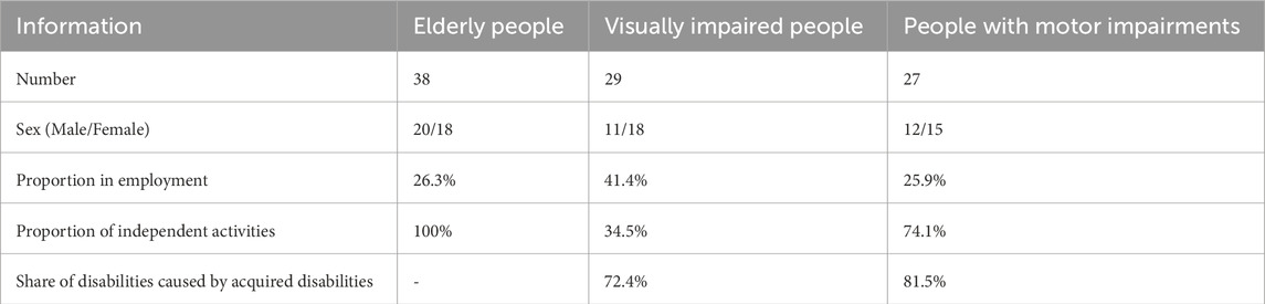
Table 1. Basic characteristics of the volunteers.
Figure 1 shows the spatial stopping point information for the three groups after filtering their residential areas. The main activity areas of the elderly are concentrated in Xinle’s old urban center, with a high share of shopping malls, restaurants, and other facilities, whereas the activity areas of the visually impaired and physically disabled are somewhat scattered.
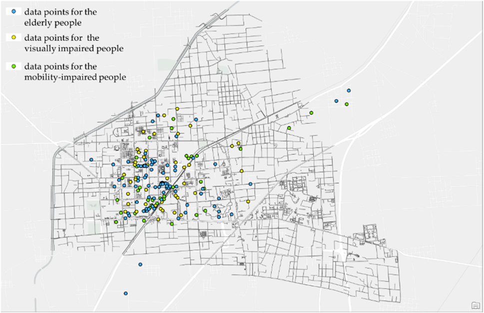
Figure 1. Spatio-temporal data points for the three groups of people.
We set up a buffer zone 10 m around the stopping point; we then counted the stay time of the volunteers in the PSFs within the buffer zone to identify the weight of the facilities. Table 2 presents the results.
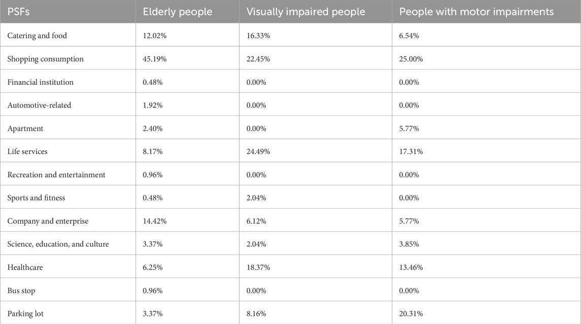
Table 2. Characteristics of the facility weights.
From the analysis of facility weight characteristics, we can see that the main types of facilities that elderly people use for daily activities are shopping and consumption facilities, companies and enterprises, and catering and food facilities, accounting for 71.63% of total importance. The main facilities for daily activities of visually impaired people are life services, shopping and consumption, and healthcare, accounting for 65.31% of total importance. The main facilities for the daily activities of the physically disabled are shopping and consumption, parking lots, and healthcare, accounting for 58.77% of total importance. At the same time, we also divided the crowd facilities into weekdays and weekends (Figure 2), and further discussed the activity characteristics and facility demand characteristics of the three types of people in Xinle City.

Figure 2. Weight of facilities on weekdays and weekends.
From the statistical results of facility weights on weekdays and weekends, it can be seen that the elderly population in Xinle City has richer facility needs compared to the other two groups. For Catering and food facilities, the needs of the elderly on weekends and weekdays are relatively close, but the two groups of disabled people show a much lower demand on weekends than on weekdays (with a difference of about 7%–10%); But for shopping consumption facilities, the demand of the elderly on weekends is higher than that on weekdays, showing completely opposite demand characteristics to the two groups of people. This may be highly correlated with the ability of the elderly to independently carry out daily activities; For Life services facilities, the daily and weekend needs of visually impaired people are almost the same, while the elderly and physically disabled people show more characteristics of daily needs. Through follow-up visits, we also learned that this is somewhat related to the organization of activities for visually impaired people; At Company and Enterprise facilities, elderly people have certain activity needs on weekdays, and some elderly people have expressed that they are still in positions of rehiring or management. At the same time, we have noticed that visually impaired people also have certain facility needs on weekends, which is highly correlated with some of their work (such as blind massage); For the Parking lot facilities, it can be seen that the demand for elderly and physically disabled people is higher on weekends than on weekdays, while the visually impaired are more evenly distributed, which may be related to their inability to engage in more activities.
Based on this, we built an important facility set consisting of six categories of facilities with high weight rates: catering and food, shopping and consumption, life services, companies and enterprises, healthcare, and parking lots. Through one-way analysis of variance (ANOVA), we identified the differential characteristics of facility importance among the three groups (Table 3).
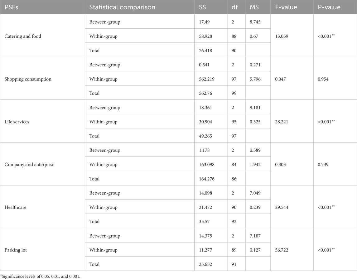
Table 3. Characteristics of differences in importance of facilities.
We found statistically significant differences in the dependence of the three groups on catering and food, lifestyle services, healthcare, and parking lots. However, the intergroup differences in shopping consumption (F = 0.047, p = 0.954) and company and enterprise (F = 0.303, p = 0.739) are not statistically significant. Hence, we inferred that the two types of PSFs for shopping consumption and company enterprises that do not have significant differences are the three types of high-frequency stay facilities for the people and have highly common characteristics regarding needs. The four kinds of PSFs—catering and food, lifestyle services, healthcare, and parking lots—reflect significant weight differences and represent the needs of different types of people, thus possessing non-common characteristics surrounding needs. As such, we further sorted the features regarding the activity and venue classification of the three groups of people in Xinle’s urban center from the perspective of the common and non-common needs of facilities (Table 4).
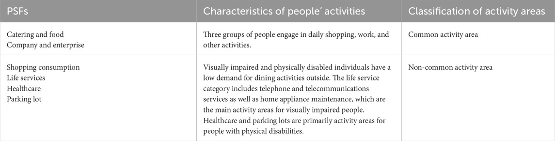
Table 4. Classification characteristics of activities and places for the three types of people.
Among non-common facilities, the need for medical facilities for visually impaired people is significantly higher than that for other people, and attention should be paid to the connection between tactile paving and life services, shopping and consumption, and healthcare. Simultaneously, the need for parking lots among people with motor impairments is significant, and attention should be paid to barrier-free links between shopping, parking lots, and healthcare.
4.2 Spatial distribution characteristics of PSFs and their compatibility with the tactile paving system
4.2.1 Identifying areas of people’s activities
Based on the features of the three types of activities and place-based classification, we analyzed the spatial kernel density of facilities and distinguished different density areas with unified colors to simulate and predict the main public activity areas for the three types of people (Figure 3). Figure 3a shows the spatial density distribution of common facilities for shopping consumption and corporate enterprises. The facility concentration areas are mostly located in the old urban part of Xinle and around the government buildings, with some distribution near the Hebei Academy of Fine Arts on the east side. Figure 3b shows the core density distribution of non-common facilities such as those related to catering, food, lifestyle services, healthcare, and parking lots. The overall concentration of facilities still revolves around the old city center, but there are also multiple potential activity areas near the Hebei Academy of Fine Arts and Xinhua Factory, with more obvious spatial differentiation characteristics than common activity areas.
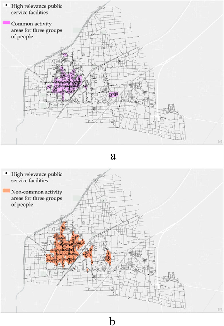
Figure 3. Layout characteristics of PSFs with a high correlation to the three groups of people. (a) Spatial distribution of common activity areas (b) Spatial distribution of non-common activity areas.
4.2.2 Construction of an accessible PAS in Xinle’s urban center
Based on the characteristics of these areas, we investigated the distribution of tactile paving in the center of Xinle. We expanded the tactile paving by 5 m on both sides to form coverage of tactile paving. Coupled with the coverage of tactile paving and related facilities, we studied and constructed a model of Xinle’s current barrier-free PAS (Figure 4).
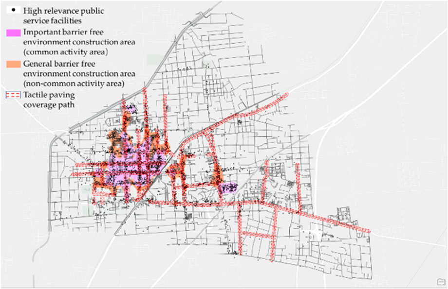
Figure 4. Accessibility public activity system in Xinle’s urban center.
The six types of facilities that are of great relevance to the three groups of people are catering and food, shopping and consumption, life services, companies and enterprises, healthcare, and parking lots. They constitute the core of an accessible PAS. As the most common type of barrier-free facility, the tactile paving system plays an important role in guiding the visually impaired and other vulnerable groups when they travel. Hence, it is an important path for support in a barrier-free PAS. At the same time, the common and non-common activity areas of people can provide a reference for the precise construction of BFEs, among which common areas can be considered key zones for BFE design and are visited by vulnerable groups. Non-common areas, owing to their targeting of specific people, are not universal and therefore general areas for BFE design.
The barrier-free PAS built in this study by coupling facilities, tactile paving, and regions can serve as a crucial guarantee for the disabled and other vulnerable groups who need to carry out daily life activities.
4.2.3 Current problems
In combination with the barrier-free PAS in Xinle’s urban center, we conducted field research on urban facilities, tactile paving, and activity areas, and summarized the existing problems in governing and design.
1. Lack of barrier-free construction of highly relevant facilities
Diverse types of highly relevant facilities are arranged primarily along the street; however, some shops and places have step height differences and lack access to ramps. At the same time, some area markings have difficulty distinguishing colors, and some signs are obscured by plants or have inappropriate heights. The high occupancy of cars and bicycles at the entrances of most shops has caused difficulties for various vulnerable groups in accessing these facilities (Figure 5). In addition, although the Fuxi Terrace Scenic Area is not the main activity area of the crowd, as the core scenic spot of the city, the overall barrier-free design is insufficient; the tactile paving, ramp, and voice prompt system are missing, and the guide map lacks Braille prompts, which cannot meet the needs of vulnerable groups.
2. The tactile paving has low compatibility with highly relevant facilities, and its construction is not standardized
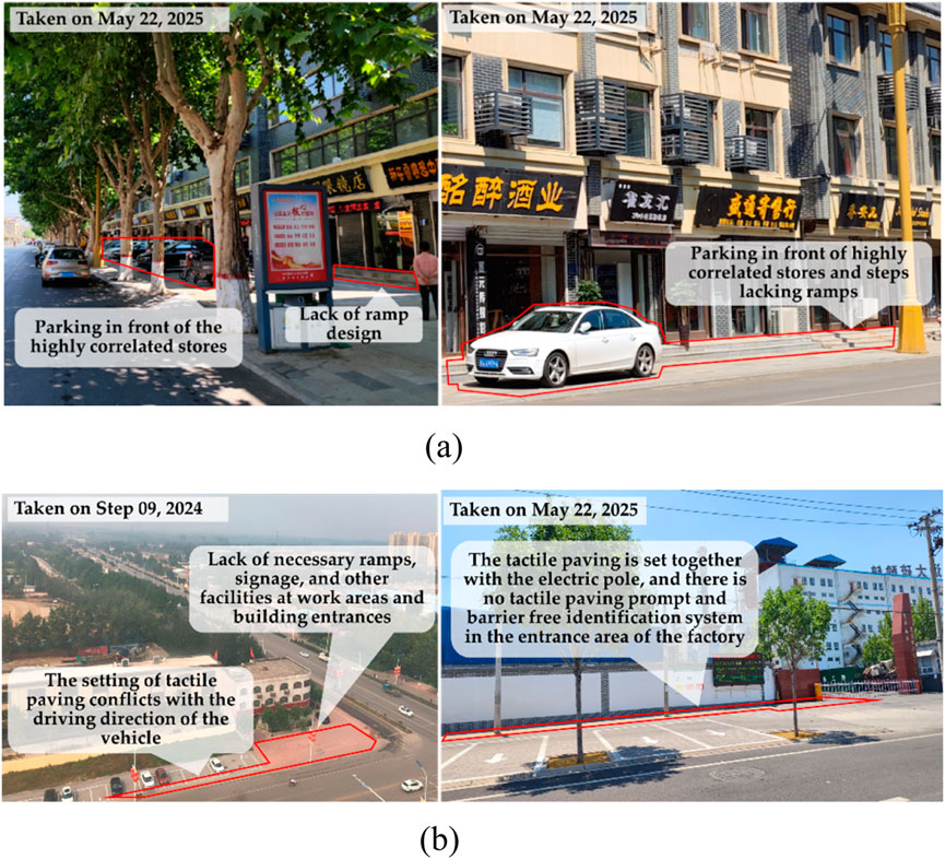
Figure 5. Lack of barrier-free construction for highly relevant facilities. (a) Shopping consumption (b) Company and enterprise.
We studied the spatial superposition of the current tactile paving system and the six types of facilities in Xinle. We took 5 m around the tactile paving as its service scope, and calculated the fit between the PSFs and the tactile paving (Table 5). In common activity areas, tactile paving has a high degree of coincidence with shopping and consumer facilities (60%) but a low degree of coincidence with company and enterprise facilities (27.9%). In non-common activity areas, tactile paving has a high degree of fit with life service facilities, reaching 73%; however, the fit with catering and food, parking lot, and healthcare is insufficient, at only 55%, 46%, and 37%, respectively.
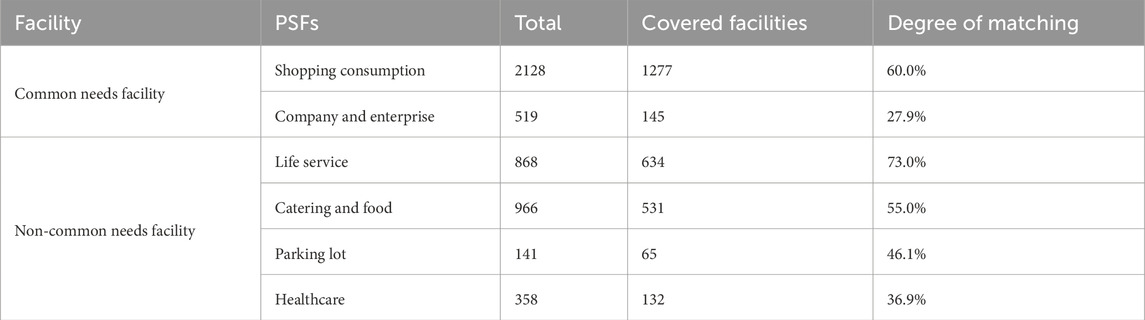
Table 5. Matching degree of tactile paving and highly relevant facilities.
Through a comparison between facilities and tactile paving, we found some problems in the construction of tactile paving in Xinle’s center. The precise design of key areas and facilities is insufficient, which cannot effectively meet people’s daily travel needs. This difference in spatial fit reflects the structural weakness of current tactile paving systems in serving specific types of PSFs. For example, a convenient connection with a tactile paving system was not fully considered when designing the entrances and exits of catering and healthcare facilities. At the same time, existing tactile paving has problems of interruption (Figure 6) and detours or unreasonable designs at critical paths to pertinent facilities (such as crosswalks and entrance ramps).
3. Poor quality of the accessible environment in activity areas
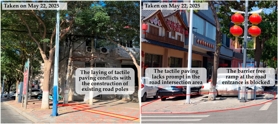
Figure 6. The construction of tactile paving is not standardized.
A survey of main activity areas revealed that apartments and rural self-built houses are the main living areas. Due to the recent construction period, the BFE around apartments is fairly good, but there is almost no barrier-free design around rural self-built houses, which lack necessary barrier-free facilities and signage guidance. In the green space related to people activities, most places lack ramps, necessary tactile paving, identification systems, and other relevant barrier-free facilities. In commercial activity spaces, some areas still have poor overall accessibility due to issues such as parking occupying lanes, stairs, and bicycles (Figure 7).
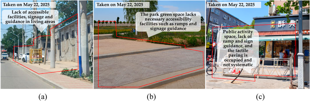
Figure 7. The construction of tactile paving is not standardized. (a) Apartment (b) Recreation and entertainment (c) Catering and food.
5 An evaluation and optimization framework for building a barrier-free public service system in Xinle
Based on an analysis of the current situation and existing problems in Xinle’s urban center, we first built an evaluation and optimization framework for a barrier-free public service system (Figure 8).

Figure 8. Evaluation and optimization framework.
First, we could researched people with disabilities and other vulnerable groups in the city, and obtained data on their activities using questionnaires and GPS. Second, we should identified relevant facilities through spatio-temporal data and selected key facilities by calculating the weight value. We performed differential detection on the weight of the third pair of facilities, clarified the common and non-common characteristics of people needing such facilities, predicted and simulated the main activity areas through the spatial distribution of facilities, and classified the importance of barrier-free design in these areas. Fourth, combine different types of activity areas with key public spaces for future urban development, and construct accessible public activity areas. Finally, based on the importance classification of barrier-free design, we refined barrier-free facility nodes, travel paths, activity areas, and public service networks into barrier-free governing and design strategies (Table 6), and a barrier-free public service system to provide a reference for the precise construction of BFEs can be established in cities.
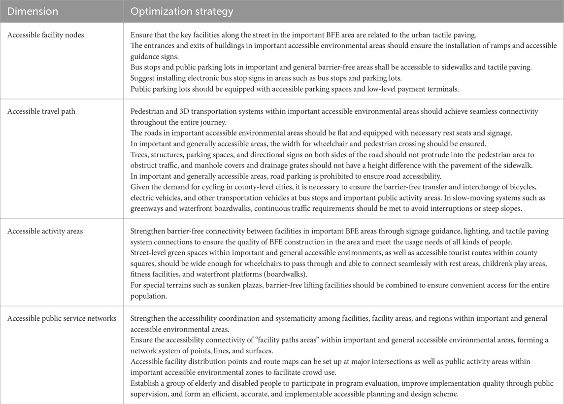
Table 6. Optimization strategy of barrier-free public activity systems.
6 Conclusion
According to warnings about the population’s structure, approximately 40% of county-level cities in China have experienced deep aging. Historical infrastructure arrears, narrow roads, and high building density are common in the urban centers of county-level cities, and accessibility renovations face spatial limitations. In addition, county-level cities are prone to facing difficulties in implementing national policies accurately due to insufficient financial, technological, and regulatory resources. Meanwhile, due to the involvement of multiple entities (such as housing and construction, civil affairs, and the Disabled Persons’ Federation) in the construction of accessible environments, county-level governments in China often face coordination difficulties due to institutional issues, which have a profound impact on the development of accessible environments in county-level cities.
In research on accessibility evaluation and optimization strategy, county-level cities do not simply apply the big city model but need to establish precise and practical solutions, which are of great significance for realizing the concept of “people’s cities” and improving the quality and fairness of urban life. The evaluation and optimization path of an accessible PAS proposed in this study can provide a basis and guidance for county-level cities or cities of the same type in the world to implement special designs and governing for accessibility and advance the construction of accessible environments. Priority can be given to ensuring the building of key areas to meet the activity needs of the vast majority of the population, even if it is not possible to meet the BFE construction requirements of the entire urban area. In addition, county-level cities should simultaneously explore the mechanism of combining accessible design with overall urban and detailed design, making accessible design a vital part of the planning system, forming a higher-level foundation and guidance, and ensuring the transmission of accessible design goals and final implementation.
This study has certain shortcomings and areas that need to be optimized and improved. In terms of data, the 93 population samples cannot represent the activity characteristics and facility demand characteristics of the elderly and disabled in Xinle City. However, we have added 10 days of spatiotemporal data collection, hoping to make up for the shortcomings brought by the sample data in terms of depth and richness. At the same time, comprehensive analysis of interview results and spatiotemporal data characteristics of the population can further improve the accuracy of activity area identification, evaluation, and the construction of accessible public activity systems. We hope that this method and approach can also provide guidance and reference for future larger scale confirmatory research. At the same time, we are also working closely with relevant departments in Xinle City to strengthen the collection of data on vulnerable groups and provide more support for future research work. In addition, the plan is to examine more county-level cities in different regions to explore practical strategies and paths for building BFEs in county-level cities in different areas, the goal being to further improve the theoretical composition and methods of barrier-free design.
Data availability statement
The raw data supporting the conclusions of this article will be made available by the authors, without undue reservation.
Author contributions
SZ: Conceptualization, Funding acquisition, Project administration, Writing – original draft, Writing – review and editing. KZ: Software, Writing – original draft, Conceptualization, Data curation, Investigation, Methodology. HZ: Validation, Writing – original draft, Formal Analysis, Software. JZ: Investigation, Validation, Writing – original draft. JC: Data curation, Project administration, Supervision, Writing – review and editing.
Funding
The author(s) declare that financial support was received for the research and/or publication of this article. This study was funded by the National Natural Science Foundation of China (52008289) and the independent innovation fund of Wuhan University of Technology (104972025RSCbs0090).
Acknowledgments
We would like to express our gratitude to the Natural Resources and Planning Bureau of Xinle City and Disabled Persons’ Federation of Xinle City, for their support.
Conflict of interest
The authors declare that the research was conducted in the absence of any commercial or financial relationships that could be construed as a potential conflict of interest.
Generative AI statement
The author(s) declare that no Generative AI was used in the creation of this manuscript.
Any alternative text (alt text) provided alongside figures in this article has been generated by Frontiers with the support of artificial intelligence and reasonable efforts have been made to ensure accuracy, including review by the authors wherever possible. If you identify any issues, please contact us.
Publisher’s note
All claims expressed in this article are solely those of the authors and do not necessarily represent those of their affiliated organizations, or those of the publisher, the editors and the reviewers. Any product that may be evaluated in this article, or claim that may be made by its manufacturer, is not guaranteed or endorsed by the publisher.
References
Chen, G., Zheng, J., and Zheng, Z. Y. (2020). Research progress and prospect of barrier-free environment in China based on CiteSpace. J. Hum. Settlements West China 35 (6), 79–87.doi:10.13791/j.cnki.hsfwest.20200611
Chen, Q. L., Han, Y. N., Zhou, Z. A., and Mao, M. R. (2024). Research on travel preferences of wheelchair users in barrier-free environments and improvement strategies for adaptive urban roads. Landsc. Archit. Front. 12 (4), 26–37. doi:10.15302/J-LAF-1-020100
Cheng, L., Chen, X., Yang, S., Cao, Z., De Vos, J., and Witlox, F. (2019). Active travel for active ageing in China: the role of built environment. J. Transp. Geogr. 76, 142–152. doi:10.1016/j.jtrangeo.2019.03.010
Chidiac, S. E., Reda, M. A., and Marjaba, G. E. (2024). Accessibility of the built environment for people with sensory disabilities—review quality and representation of evidence. Buildings 14, 707. doi:10.3390/buildings14030707
China Press for Persons with Disability (2025). There is no difference in urban and rural services! how can this top 100 county in the country ensure smooth and unimpeded travel for people with disabilities? Available online at: https://mp.weixin.qq.com/s?__biz=MzAxMDA1Njg5Mg==&mid=2650505639&idx=1&sn=62eb32e164539aeae56aebeb7024592e&chksm=825f23e6e108ff710d05994b118a01c633befa87f5dd22cc2465dd8e9d91d7ed2ad6b09bae3c&scene=27 (Accessed September 9, 2025).
Dai, J., Chen, X. L., and Song, Y. (2023). A review of the inclusive trend of accessible facilities for the visually impaired in the street environment: Comparison and enlightenment based on the United States, Great Britain and Japan. J. Hum. Settlements West China 38 (5), 65–72. doi:10.13791/j.cnki.hsfwest.20230510
Deng, L. Y., and Zhang, N. (2015). Study on the barrier-free system of public spaces in Japan. Urban Plan. Int. 30 (S1), 106–110. Available online at: http://CNKI:SUN:GWCG.0.2015-S1-017
Deng, Z. Q., and Zhou, L. G. (2022). The challenges and support system of urban barrier free environment construction. Urban Probl. 3, 24–32. doi:10.13239/j.bjsshkxy.cswt.220303
Eisenberg, Y., Heider, A., Gould, R., and Jones, R. (2020). Are communities in the United States planning for pedestrians with disabilities? Findings from a systematic evaluation of local government barrier removal plans. Cities 102, 102720. doi:10.1016/j.cities.2020.102720
Fan, L., Xiong, Y., and Peng, Y. (2024). Assessing accessible travel satisfaction in old communities: a SEM study. Buildings 14, 1273. doi:10.3390/buildings14051273
Henderson-wilson, C., Andrews, F., Wilson, E., and Tucker, R. (2022). Global benchmarking of accessible and inclusive cities. J. Soc. Inclusion 13 (1), 42–65. doi:10.36251/josi258
Hu, X. F., and Xia, Q. (2019). Study on spatial mismatch and majorization of barrier-free facilities for urban community: a case study of nanjing. Disabil. Res., 63–70. Available online at: http://CNKI:SUN:CJRY.0.2019-03-012
Hua, X., Pan, H., Wang, X., and Cui, J. (2025). Removing the barriers to constructing barrier-free streets in old neighbourhoods: evidence from shanghai. Urban Policy Res. 43 (2), 137–157. doi:10.1080/08111146.2025.2481512
Jiang, Z., Wu, C., and Chung, H. (2025). The 15-minute community life circle for older people: walkability measurement based on service accessibility and street-level built environment – a case study of suzhou, China. Cities 157, 105587. doi:10.1016/j.cities.2024.105587
Li, B., Li, T., and Zhu, Y. (2015). Equalization of public Services,Financial expenditure on people's livelihood and Urbanization-an empirical study based on dynamic spatial econometrics models by use of panel data from 286 cities of China. China Soft Sci. 6, 79–90. Available online at: http://CNKI:SUN:ZGRK.0.2015-06-008
Loeschcke, G., and Pourat, D. (2022). Barrierefreie Verkehrs-und Freiräume: kommentar zur DIN 18040-3: handbuch und Planungshilfe. Berlin: DOM publishers.
Manley, S. (1996). Walls of exclusion: the role of local authorities in creating barrier-free streets. Landsc. urban Plan. 35 (2-3), 137–152. doi:10.1016/0169-2046(96)00310-6
Ravi, K. E., Fields, N. L., and Dabelko-Schoeny, H. (2021). Outdoor spaces and buildings, transportation, and environmental justice: a qualitative interpretive meta-synthesis of two age-friendly domains. J. Transp. and Health 20, 100977. doi:10.1016/j.jth.2020.100977
Shen, X., Zheng, S., Wang, R., Li, Q., Xu, Z., Wang, X., et al. (2023). Disabled travel and urban environment: a literature review. Transp. Res. Part D Transp. Environ. 115, 103589. doi:10.1016/j.trd.2022.103589
SJZ Gov.cn (2023). Shijiazhuang statistical yearbook. Available online at: https://tjj.sjz.gov.cn/columns/7de8ce3b-2c70-4ea5-a3eb-e084223b5c52/202408/22/fb01aa74-a399-40f0-a3ea-af135cdfa641.html (accessed on March 7, 2025).
Sun, J. W., Jiang, Z., and Hu, J. Y. (2022). Spatio-temporal evolution pattern and driving factors of high-quality development of Chinese cities in the new era. Geogr. Res. 41 (7), 1864–1882. Available online at: http://CNKI:SUN:DLYJ.0.2022-07-005
Sun, J. L., Suo, H. Y., and Chen, G. (2023). The construction of accessible environment in Chinese modernization: significance, development and path. Disabil. Res. 3, 38–46. Available online at: http://CNKI:SUN:CJRY.0.2023-03-005
Tan, Y. P., and Chen, Y. F. (2025). Research progress and commentary on the domestic rural barrier-free environment based on CiteSpace. Dev. Of Small Cities and Towns 43 (S3), 64–73. Available online at: http://CNKI:SUN:XCJS.0.2025-03-008
Tang, P., and Dong, N. (2022). Everyone counts-creating inclusive and friendly urban spaces. Landsc. Archit. Front. 10 (3), 8–11. doi:10.15302/j-laf-1-010024
Tucker, R., Kelly, D., Frawley, P., Johnson, L., Andrews, F., Murfitt, K., et al. (2023). Overcoming obstacles to accessibility and inclusivity in an Australian regional city: a transdisciplinary research approach. Urban policy Res. 41 (3), 262–278. doi:10.1080/08111146.2022.2103670
Van Hoven, B., Fisher, M., and Munuera Garcia, J. (2024). Mapping the inclusive city: engaging people with disabilities as Co-Researchers in Groningen (the Netherlands). Community Dev. 55, 842–857. doi:10.1080/15575330.2024.2310848
Wang, X. H. (2025). Hebei disabled persons' Federation makes efforts in the 14th five year plan: more solid guarantee of people's livelihood, warmer care services | extra care extraordinary five years. China Times. Available online at: http://baijiahao.baidu.com/s?id=1840400633830396405&wfr=spider&for=pc (Accessed September 9, 2025).
Wang, X. Q., Qi, W., and Liu, S. H. (2020). Spatial distribution and driving factors of small towns in China. Geogr. Res. 39 (2), 319–336. Available online at: http://link.cnki.net/urlid/11.1848.p.20191224.1437.004
Wen, F., and Zhang, B. (2020). Enlightenment of the future-oriented comprehensive barrier-free in German cities. Constr. Sci. Technol. 11, 59–63. doi:10.16116/j.cnki.jskj.2020.11.012
Wen, Y., Li, Y., Yang, Y., and Wang, J. (2023). Towards an evaluation system of disabled individuals’ friendly communities from the perspective of inclusive development—A case study in jinan. Buildings 13, 2715. doi:10.3390/buildings13112715
Xiang, Y. F., and Wang, Y. H. (2025). Performance evaluation of urban barrier-free environment: a case study of shenhe district, shenyang city. Urban Gov. 26, 20–24. doi:10.16242/j.cnki.umst.2025.01.009
Xiong, X., Yu, X. H., and Wang, Y. X. (2018). Measurement and influencing factors of regional basic public service equalization level in China. J. Southwest Minzu Univ. Humanit. Soc. Sci. Ed. 39 (3), 108–116. Available online at: http://CNKI:SUN:XNZS.0.2018-03-016
Xu, Q. X. (2015). Cracking the dilemma of barrier free environment construction: from the perspective of social governance theory. J. Hohai Univ. Philosophy Soc. Sci. 17 (06), 43–48+98. Available online at: http://CNKI:SUN:HHZX.0.2015-06-009
Yang, H., Peng, J., Lu, Y., Wang, J., and Yan, X. (2024). Nonlinear impact of built environment on people with disabilities’ metro use behavior. Appl. Geogr. 169, 103323. doi:10.1016/j.apgeog.2024.103323
Ye, J. Y., and Su, H. Y. (2021). Research on social integration of the disabled in China in the new era. Popul. Dev. 27 (1), 3–15. Available online at: http://CNKI:SUN:SCRK.0.2021-01-002
Zhang, Y. Y., and Ge, Z. M. (2017). The impact of different disabilities on the quality of life of elderly people in China. Popul. Soc. 33 (4), 33–42. doi:10.14132/j.2095-7963.2017.04.004
Zhang, C. L., Du, L. J., and Ma, J. S. (2019). Research on quality evaluation of new-type urbanization of county territory. J. Hebei Univ. Econ. Bus. 40 (1), 102–108. doi:10.14178/j.cnki.issn1007-2101.2019.01.014
Zhang, S., Yang, Y., Zhen, F., Lobsang, T., and Li, Z. (2021). Understanding the travel behaviors and activity patterns of the vulnerable population using smart card data: an activity space-based approach. J. Transp. Geogr. 90, 102938. doi:10.1016/j.jtrangeo.2020.102938
Zhao, Z. L., Yan, G., Zhou, Q., Zhang, Y. S., and Qiu, Y. (2014). A comparative study on accessible construction of urban environment in China and the selected countries. Urban Dev. Stud. 21, 4–7. Available online at: http://CNKI:SUN:CSFY.0.2014-04-023
Keywords: county-level city, vulnerable group, urban public service facilities, activity area, barrier-free environments
Citation: Zhang S, Zhang K, Zhao H, Zhang J and Chen J (2025) The fine evaluation and optimization strategy of barrier-free public activity systems from the perspective of a county-level city: Xinle, Hebei Province. Front. Built Environ. 11:1695161. doi: 10.3389/fbuil.2025.1695161
Received: 29 August 2025; Accepted: 18 September 2025;
Published: 07 October 2025.
Edited by:
Yang Zhang, Chengdu University of Technology, ChinaCopyright © 2025 Zhang, Zhang, Zhao, Zhang and Chen. This is an open-access article distributed under the terms of the Creative Commons Attribution License (CC BY). The use, distribution or reproduction in other forums is permitted, provided the original author(s) and the copyright owner(s) are credited and that the original publication in this journal is cited, in accordance with accepted academic practice. No use, distribution or reproduction is permitted which does not comply with these terms.
*Correspondence: Jianyu Chen, anljaGVuQHdodXQuZWR1LmNu
†These authors have contributed equally to this work and share first authorship