 Laura Benegas1*†
 Ney Ríos Ramírez1Líber Ilyá Fino Rodríguez1Carlina Felicia Mosquera Ballejos1,2Ovidio Ibáñez López1
- 1Centro Agronómico Tropical de Investigación y Enseñanza (CATIE), Turrialba, Costa Rica
- 2Ministerio de Ambiente de Panamá, Panamá, Panama
This study explores the operationalization of nature-based solutions (NbS) for watershed resilience in two contrasting Latin American contexts: the Caimito watershed in Panama and the El Coyolar watershed in Honduras. The methodological framework combined spatial multi-criteria analysis using GIS tools, participatory mapping with local stakeholders, and the classification of NbS based on ecological function and governance feasibility. Results show that a total of 1,220 ha and 1,870 ha were prioritized for NbS interventions in Caimito and El Coyolar, respectively. The most feasible practices included urban green corridors, riparian buffer restoration, and agroforestry infiltration systems. Notably, Panama followed an institutionally driven planning process, whereas Honduras adopted a community-led strategy. The study highlights the importance of integrating spatial tools with local knowledge to ensure effective and context-sensitive NbS implementation.
Introduction
Watersheds across Latin America are under increasing pressure due to unplanned urban growth, intensive agricultural practices, deforestation, and the rise in extreme hydrometeorological events. These stressors disrupt hydrological functions, threaten biodiversity, and diminish the capacity of ecosystems to provide critical services, ultimately intensifying socio-environmental vulnerabilities (Millennium Ecosystem Assessment, 2005; IPBES, 2019; Vogl et al., 2017).
Nature-Based Solutions (NbS) have gained global recognition for their potential to address such complex watershed challenges by restoring and enhancing natural processes while providing socioeconomic co-benefits (Cohen-Shacham et al., 2016; Raymond et al., 2017; Kabisch et al., 2016). Examples of NbS include forest and riparian restoration, agroforestry, green infrastructure, and slope stabilization—all of which can be strategically deployed to mitigate erosion, floods, and water quality degradation (UNESCO World Water Assessment Programme, 2018).
Effective planning and implementation of Nature-Based Solutions (NbS) require spatially explicit, robust methodologies that integrate watershed-scale assessments, land use suitability, and biophysical criteria. According to Locatelli et al. (2015), combining climate mitigation and adaptation objectives in forestry and agriculture requires geographic tools capable of aligning interventions with spatial variability in land capacity and environmental risks. Similarly, Verdone and Seidl (2017) highlight the importance of place-based analysis in achieving global restoration goals, stressing that success depends on understanding ecological and socio-spatial dynamics at the landscape level. These insights support the use of geospatial techniques, such as digital elevation models (DEMs), terrain and hydrological modeling, and land cover analysis, to guide the prioritization and zoning of NbS at the watershed scale, enabling more context-relevant and effective planning.
Studies exploring the planning and implementation of Nature-Based Solutions (NbS) in urban and peri-urban watershed contexts, such as those by Frantzeskaki et al. (2019) on urban sustainability strategies and Narayan et al. (2017) on coastal wetland protection, demonstrate the effective use of open-access and low-cost geospatial platforms (including SAGA GIS, ArcGIS, and Google Earth Pro) together with publicly available datasets like Sentinel-2, SRTM, and ALOS. These tools were applied to generate actionable outputs, including NbS zoning maps, ecological connectivity corridors, and overlays of hydrological or flood risk. Critically, both studies highlight the role of participatory validation and integration with local planning instruments, underscoring how technically sound, stakeholder-informed outputs can support municipal authorities in mainstreaming NbS into climate resilience and territorial planning strategies.
Developing countries often remain sidelined in global NbS research, despite the pressing need to advance context-specific Nature-Based Solutions in these regions. Progress requires attention to local priorities, restoration of biodiversity, and a commitment to long-term sustainability. Achieving meaningful results hinges on inclusive governance, robust capacity-building, and adequate international funding—without which efforts are unlikely to move beyond rhetoric (Zyoud and Zyoud, 2025). In this light, the synthesis of spatial diagnostics, land capability criteria, and NbS principles demonstrates how technically grounded, replicable approaches can guide watershed restoration and sustainable land management in Latin America and beyond.
Despite the growing number of studies applying spatial diagnostics and geospatial tools to NbS planning (Frantzeskaki et al., 2019; Narayan et al., 2017; Mubeen et al., 2020), several methodological gaps remain unaddressed. Many existing frameworks are designed for data-rich or high-income contexts, often overlooking the constraints and institutional fragmentation present in developing regions (Kabisch et al., 2016; Wendling et al., 2018). Notably, few methodologies offer integrated approaches that align geospatial analysis with participatory governance tools, land-use regulatory instruments, and institutional mandates (Meerow and Newell, 2017). Furthermore, literature is scarce on practical implementation pathways that bridge technical diagnostics with municipal planning processes in peri-urban and rural watersheds of Latin America. Finally, the cost or complexity of many methodologies limits their application by local governments (Palomo et al., 2021). This study seeks to fill this gap by proposing and testing a replicable, place-based methodology that operationalizes NbS through spatial diagnostics, zoning criteria, and actor engagement strategies tailored to resource-constrained contexts.
To respond to the urgent need for grounded, context-specific approaches to Nature-Based Solutions in watershed management, this study examines and compares the implementation pathways of NbS in two watersheds in Latin America: the Caimito River basin in Panama and the El Coyolar subwatershed in Honduras. Drawing on spatial diagnostics, stakeholder mapping, and governance analysis, the research aims to: (i) identify and justify appropriate NbS options through geospatial and participatory tools; (ii) delineate spatial priorities for action within each watershed based on ecological and land-use criteria; and (iii) construct practical, stepwise implementation roadmaps that align with institutional, social, and territorial planning frameworks. In doing so, the study contributes operational insights to the broader field of NbS planning and implementation in data-constrained and institutionally fragmented contexts, supporting the integration of ecosystem-based strategies into policy and practice across tropical watersheds.
Materials and methods
Study area and context
This research was conducted across three watershed contexts in Panama and Honduras: the Caimito River Basin (Panama Oeste) and the El Coyolar Sub-basin (Honduras), in Honduras (Figure 1). Each study area represents distinct biophysical and socio-political conditions but shares common challenges associated with hydrometeorological risks, land degradation, and ecosystem service decline. The watersheds are characterized by varying degrees of urban pressure, deforestation, erosion, and vulnerability to floods and droughts.
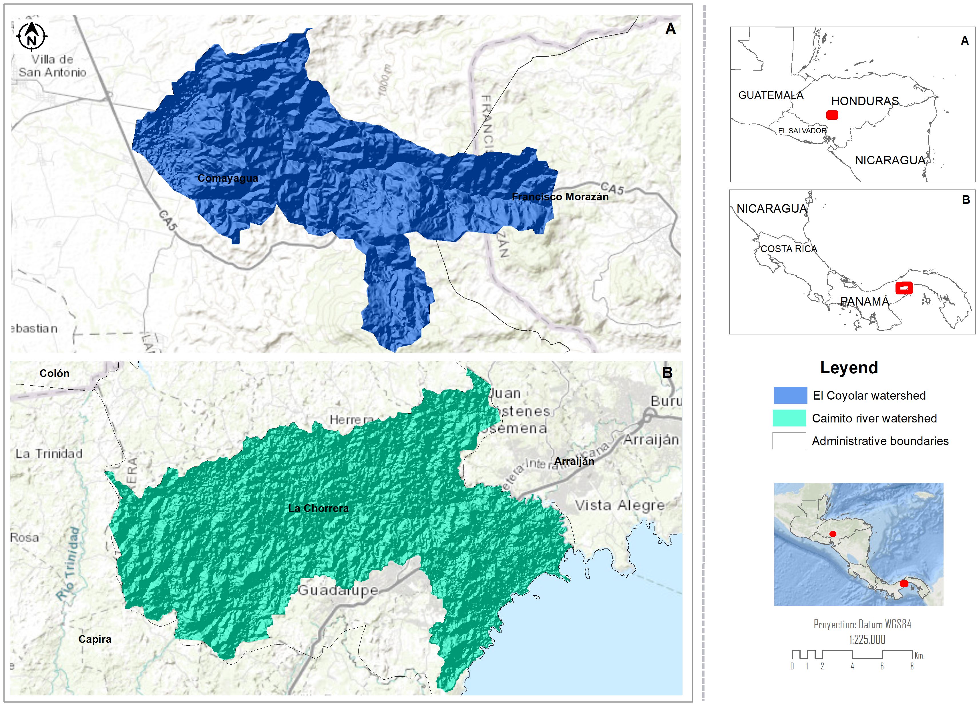
Figure 1. Location of study sites: (A) El Coyolar subwatershed, and main panel A) general location of El Coyolar subwatershed in Honduras; (B) Caimito river watershed, and main panel B) general location of Caimto river watershed in Panama.
Caimito river basin by Caimito river watershed
The Caimito River Watershed, officially classified as Watershed 140 in Panama’s national hydrological system, is located within the province of Panamá Oeste. The watershed spans approximately 454.7 km², with the Caimito River being the principal watercourse, measuring 72.83 km in length and surrounded by a perimeter of 185.75 km. In addition to the Caimito River, key tributaries include the rivers Martín Sánchez, Congo, and Caimitillo. The urban growth, especially in La Chorrera, has led to issues with urban runoff and increased flood risk due to insufficient drainage infrastructure and deforestation in upper areas. The watershed extends across three major districts in Panamá Oeste: La Chorrera, Arraiján, and Capira (Caballero et al., 2013). La Chorrera is the most extensive district and includes the most urbanized areas, such as the Colón, Balboa, and El Coco neighborhoods, which exhibit the highest urban population densities—over 1,000 inhabitants per square kilometer (INEC, 2010). The topography varies from flat lowlands in the southern and urban areas to hilly terrain in the north. The highest elevation is found at Cerro Trinidad in Capira, rising to 560 meters above sea level, which also serves as the headwaters of the river. The average slope ranges from 13% in the northwest to lower gradients near the coast (Caballero et al., 2013).
The watershed is characterized by a tropical savanna climate (Aw) under the Köppen classification, with annual precipitation below 2,500 mm and a dry season with less than 60 mm of monthly rainfall. The average annual temperature is around 26 °C. Soils are generally deep and clay-rich. Approximately 40% of the watershed consists of non-arable soils (Class VI) suitable mainly for forests and conservation, while around 14% (Class III) is suitable for agriculture with significant limitations. The dominant land uses include pastures (52%), secondary mixed broadleaf forest (26%), and urban areas (16%). The watershed falls primarily within the Tropical Humid Forest life zone (94%) and a smaller area of Very Humid Premontane Forest (6%), supporting diverse flora and fauna (Lopez, 2009). However, this biodiversity is under pressure from urban expansion, agriculture, and infrastructure development.
The area has seen rapid demographic growth, particularly in Arraiján and La Chorrera, due to internal migration from other provinces. Economic activities include pineapple farming in La Chorrera, fishing and agriculture in Vacamonte and Puerto Caimito, and industrial development in Arraiján. However, urban expansion has frequently occurred without comprehensive planning, exacerbating environmental degradation and water resource stress.
El Coyolar subwatershed
The El Coyolar subwatershed is located in the municipality of Ojojona, within the Department of Francisco Morazán, Honduras. It forms part of the upper Choluteca River watershed, one of the main sources of water for the capital city, Tegucigalpa (JICA (Japan International Cooperation Agency), 2008; GWP Central America, 2021). El Coyolar lies within the subtropical highland zone and includes part of the La Tigra National Park buffer zone, an area critical for water production and ecosystem conservation. This subwatershed is considered hydrologically strategic due to its role in contributing to the Los Laureles Reservoir, a primary source of drinking water for Tegucigalpa (Rodríguez Cruz, 2022; JICA (Japan International Cooperation Agency), 2008). The Coyolar River, along with minor tributaries, flows from forested headwaters and joins the larger Choluteca River system (GWP Central America, 2021). Its stream network is dense and dendritic, showing good potential for water retention if sustainably managed. However, some stream sections suffer from reduced baseflow and sedimentation, indicating upstream degradation (Rodríguez Cruz, 2022).
Both the Caimito and El Coyolar watersheds exhibit a pronounced tropical seasonality, characterized by a dry season from December to April and a rainy season from May to November. In the Caimito watershed (Panama), annual precipitation ranges from approximately 1,600 to 2,000 mm, with the highest rainfall occurring between September and November. Mean annual temperatures vary from 25°C to 27°C. Similarly, in the El Coyolar watershed (Honduras), annual precipitation is estimated between 1,200 and 1,800 mm, with peaks between June and October (FAO (Food and Agriculture Organization of the United Nations), 2023). Temperatures range from 24°C to 28°C. This climatic seasonality significantly influences hydrological processes and the delivery of ecosystem services in both watersheds. Soils are primarily Inceptisols and Entisols, moderately fertile, but vulnerable to erosion under steep slopes and with intensive use or vegetation loss (Simmons and Castellanos, 1969; Baumann and Jaco, 2024).
Land use in the subwatershed is a mix of: Forests (native pine-oak and cloud forest fragments), which represent approximately 40% of the area, pastures and degraded lands with approximately 30%, subsistence agriculture (maize, beans, horticulture) covering approximately 20% of the area and human settlements and roads with around 10% (GWP Central America, 2021)Forest areas provide essential ecosystem services, especially water regulation and erosion control, but face threats from unregulated timber extraction, grazing, and expanding agriculture.
The population is rural, with subsistence farming and livestock as primary livelihoods. Many households rely on community-managed water systems (Juntas de Agua) for supply (JICA (Japan International Cooperation Agency), 2008; GWP Central America, 2021). The community has limited access to public services and faces pressure from upstream-downstream conflicts, particularly regarding supply reliability for Tegucigalpa. There are local organizations and environmental education efforts, but institutional coordination remains weak, especially in integrating watershed planning and conservation financing mechanisms.
Data collection and sources
We used mixed-methods approach, integrating: a) Geospatial data (high-resolution satellite imagery and GIS layers from national cartographic agencies and open-access platforms), b) Analysis of Institutional instruments (municipal land-use plans, zoning regulations, watershed management plans, and risk reduction frameworks), c) Field validation, with site visits, aerial photography (drone-based in one case), and participatory mapping with community stakeholders, d) Primary information collected through semi-structured interviews with local government officials, water users, and civil society actors involved in watershed governance.
Diagnostic assessment framework
To build a baseline for identifying areas of intervention and understanding the drivers of ecosystem service degradation to further propose site-specific NbS, we conducted multi-dimensional diagnostics in each study case to evaluate: a) Biophysical characteristics of topography, land use/land cover, hydrology, soil capacity, slope, and vegetation, b) Socioeconomic indicators including settlement patterns, exposure to hazards, land tenure, and economic activities, and c) Identification of zones susceptible to flooding, landslides, and drought using historical records, drainage density, and slope analysis.
Identification and selection of nature-based solutions
We selected specific NbS for each study site following a systematic analysis of priority ecosystem services, particularly water regulation, erosion control, and microclimate regulation. With the clear identification of priority ecosystem services we add an analysis of vulnerability hotspots where we included densely populated areas, critical drainage corridors, and erosion-prone slopes. Finally, we consider the alignment with local governance instruments such as zoning ordinances, municipal landscape plans or watershed management plans. Based in the watershed management approach and NbS framework, we identify in a preliminary stage, a basic typology of NbS to be considered fundamental for our study sites. This typology covers five categories: 1) riparian and hillside reforestation, 2) restoration of degraded riverbanks, 3) creation of green and urban corridors and retention areas, 4) implementation of permeable surfaces and bioretention infrastructure, and 5) watershed-scale agroecological zoning.
Spatial analysis and zoning
We used QGIS and SAGA-GIS to generate slope, drainage and land use overlays, to delineate micro-basins and floodplains, to prioritize intervention zones through multicriteria analysis, and to develop zoning maps integrating NbS suitability and legal constraints. Maps were validated with municipal technical teams and community stakeholders to ensure feasibility and compliance with planning instruments. Table 1 summarizes the tools and analysis employed for each study site.
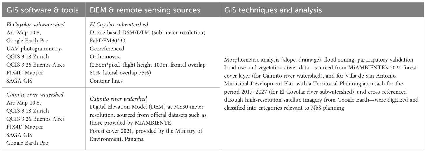
Table 1. Summary of spatial tools, data sources, analysis and main results for each study site.
For El Coyolar subwatershed, a Digital Elevation Model (DEM) of 30m x 30m resolution was obtained and used as the primary source for generating contour lines and the hydrographic network. The SAGA software was employed to process the DEM and extract key terrain attributes: Slope, LS Factor (a combined topographic factor related to erosion potential), and Terrain Ruggedness Index (TRI). ArcGIS tools were utilized to calculate line density metrics, specifically the density of contour lines and river networks, which represent the spatial concentration of these features. A classification scheme for susceptibility levels was created, categorizing areas into Low, Medium, and High susceptibility based on the integrated analysis. Standardization of diverse variables was performed using a min-max normalization formula to bring all raster datasets to a comparable scale (0 to 1). A composite raster was calculated by summing the standardized values of the Terrain Ruggedness Index, Slope, LS Factor, Contour Density, and River Density to produce a final susceptibility map.
For the Caimito river watershed study we followed a geospatial analysis process centered around the use of QGIS, complemented by open-source tools (RSAGA). The analysis began with the acquisition of a Digital Elevation Model (DEM) at 30x30 meter resolution, sourced from official datasets provided by MiAMBIENTE. This DEM was used to generate fundamental topographic products, including contour lines and the hydrographic network, clipped to the study area using QGIS raster tools. Hydrological and terrain variables were then derived using the SAGA GIS interface within QGIS, producing layers such as slope, the LS Factor (length-slope factor, relevant to erosion potential), and the Terrain Ruggedness Index (TRI), which captures terrain complexity.
In parallel, land use and vegetation cover data sourced from MiAMBIENTE’s 2021 forest cover layer and cross-referenced through high-resolution satellite imagery from Google Earth, were digitized and classified into categories relevant to NbS planning, such as urban forest, green corridors, mangrove protection zones, and river renaturalization areas. These layers served as the foundation for the spatial delimitation of NbS zones. Each polygon was digitized based on biophysical suitability, including slope gradients and proximity to water bodies, with QGIS vector tools, and areas were calculated using the field calculator. The final raster layers, once standardized, were summed to produce an integrated susceptibility map. This resulting raster was then reclassified into three classes of susceptibility (low, medium, and high), which helped guide the prioritization and zoning of NbS interventions across the watershed.
The process concludes for both study cases, with the design of cartographically coherent maps with ArcMap 10.6.1, displaying spatial zones with corresponding color symbology, labels, and metrics that support decision-making. In this study, the accuracy of the spatial prioritization process refers to the degree to which the geospatial data and derived products reliably represent the real-world conditions of the study area. While no independent quantitative accuracy assessment (e.g., confusion matrix or Kappa coefficient) was conducted, reliability was ensured by using official datasets from national cartographic agencies, cross-checking with recent high-resolution satellite imagery (≤0.3 m) and aerial photographs and validating the delineation of NbS zones through field visits and participatory mapping sessions with local stakeholders. This combination of authoritative sources and on-site verification reduced potential errors in spatial representation and classification. Figure 2 summarizes the GIS process employed in both study cases.
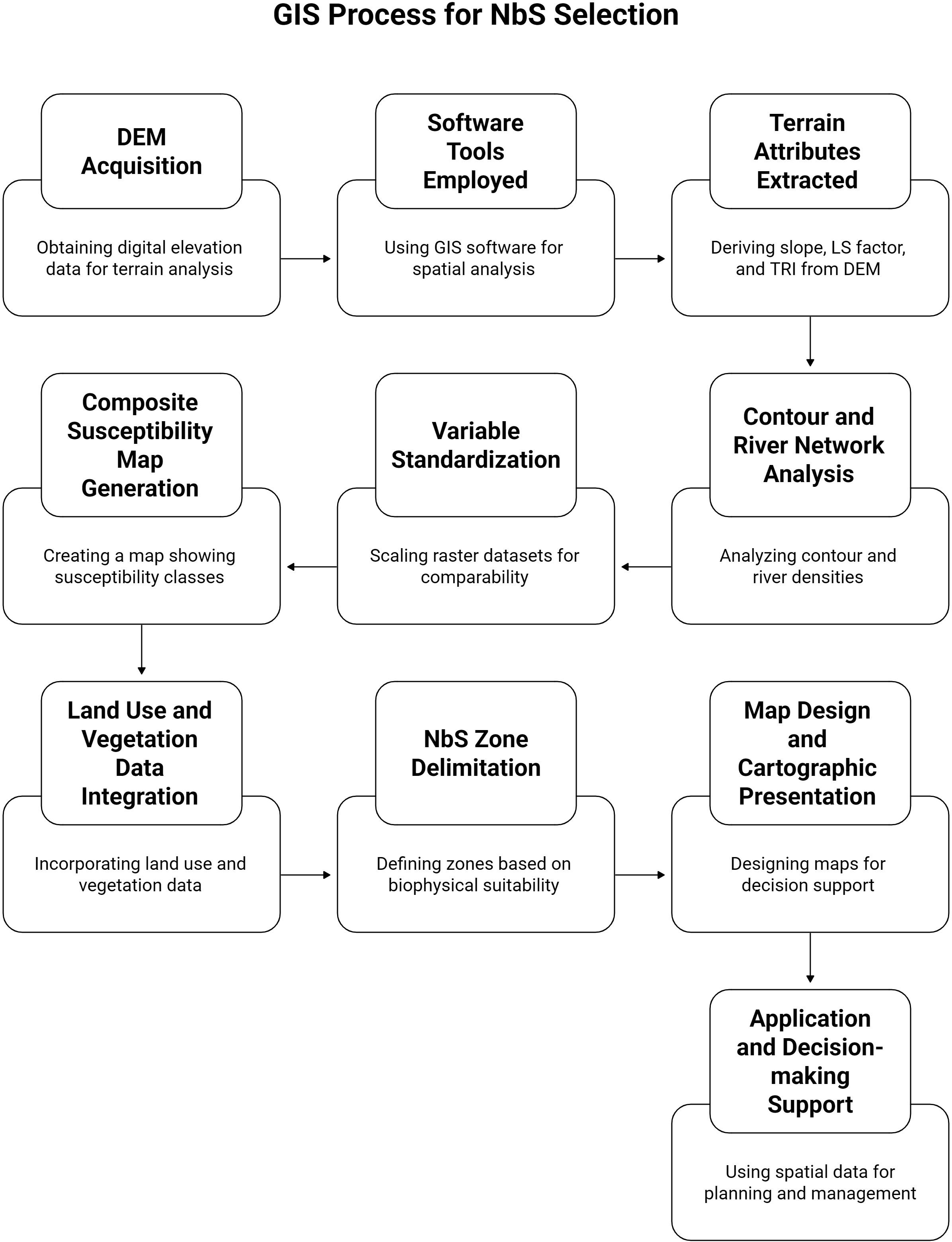
Figure 2. Summary of the GIS process for NbS selection in both study cases.
Institutional and actor analysis
We did stakeholders and institutional mapping exercises in each study case to identify key actors in watershed governance (public, private, and community-based), to understand the roles, mandates, and influence across the watershed governance structure, and to assess gaps and opportunities for multi-level coordination and participation in NbS implementation. We applied an interest–influence matrix to visualize the roles and engagement potential of key actors across government, civil society, and the private sector, following the participatory typologies of Reed et al. (2009) and the SAS2 framework (Chevalier and Buckles, 2013).
Formulation of NbS proposals and implementation pathway
We follow an iterative process to build the specific implementation pathways of selected NbS in our study sites, combining field visits with key stakeholders and expert consultations. The aim was not only to define what will be implemented, but how and under what conditions NbS interventions can be effective, legitimate, and sustainable. To build such a pathway, we manage a series of key questions posed and answered through multidisciplinary dialogue, spatial analysis, literature review, and stakeholder engagement. These questions were:
What is the landscape context we are working in? This includes understanding the watershed’s ecological dynamics, social structures, and governance frameworks. A base geospatial framework was created, as described in section 2.5.
Who are the stakeholders that must be involved and what roles do they play? Basic stakeholder analysis helps clarify whose influence and interest shape or are shaped by NbS interventions. Engagement activities are then planned to validate priorities, address social acceptability, and integrate local knowledge into technical planning.
What types of NbS are contextually appropriate and feasible to implement? This involves evaluating technical options (such as reforestation, riparian restoration, or green infrastructure) against ecological needs and operational constraints. It also requires defining the enabling conditions: policy frameworks, funding sources, technical capacity, and logistical feasibility. At this stage, the pathway begins to take shape as a sequence of steps: preparation, implementation, monitoring, and scaling.
How will implementation be monitored and improved over time? Monitoring indicators must be chosen that reflect the goals of NbS (e.g., erosion control, water retention, biodiversity enhancement), and the means to collect and interpret data must be appropriate to local capacities. Feedback loops should be integrated, so that field data can inform adaptive management, policy decisions, and potential replication in other sites.
How will learning be captured and shared for future application? A robust pathway includes mechanisms for documenting lessons, synthesizing findings, and evaluating performance—both technically and socially. This allows for upscaling through institutional learning, strategic partnerships, and the co-development of roadmaps for broader territorial impact.
Results
Selection of NbS for The Caimito river watershed and El Coyolar subwatershed
The proposed Nature-Based Solutions (NbS) across the two watershed case studies exhibit varied typologies, spatial scales, and strategic orientations, reflecting the biophysical context and development dynamics of each site. Table 2 presents the synthesis of main watershed management issues, critical ecosystems affected, key drivers of degradation and corresponding NbS selected for both study sites. The spatial quantification of NbS interventions (Table 3) provides valuable insight into the prioritization logic and territorial opportunities for ecosystem-based watershed management.
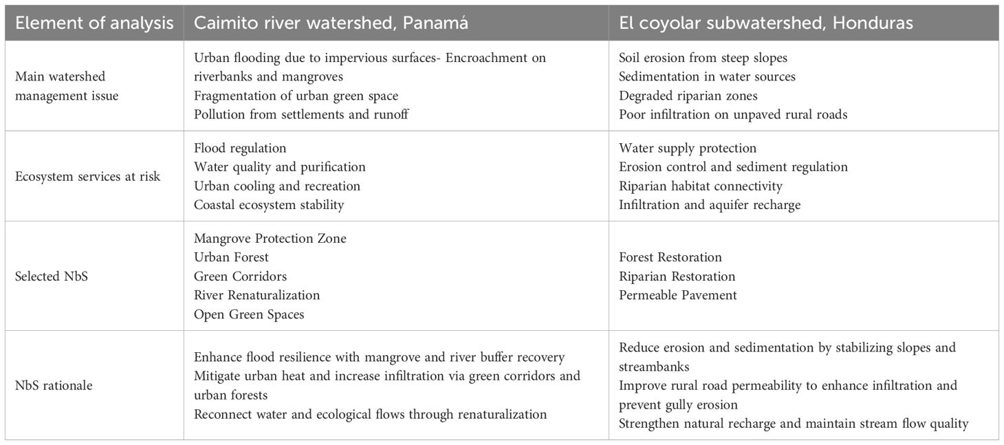
Table 2. Synthesis and rationale of selected NbS for the Caimito river watershed and El Coyolar subwatershed.
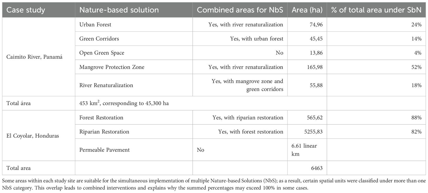
Table 3. Selected NbS and potential areas for implementation in each study site.
In Caimito, an urbanized and coastal watershed, the prioritized NbS (mangrove protection, green corridors, and urban forests) respond directly to problems linked to urban expansion, flooding, and loss of ecological connectivity. These measures enhance flood regulation, support water purification, and restore key ecological functions within densely populated areas. In contrast, El Coyolar, characterized by steep topography and rural land use, focuses on forest and riparian restoration alongside the application of permeable pavements on unpaved roads. These interventions target erosion control, sediment load reduction, and groundwater recharge, aiming to sustain the hydrological integrity of upstream water sources critical to urban water supply.
Despite their differing contexts, both study sites demonstrate strategic NbS selection, rooted in local environmental diagnostics and landscape functionality. The Caimito case highlights opportunities for integrating NbS into urban planning and disaster risk reduction frameworks, while El Coyolar presents a model for rural restoration and water source protection.
In the Caimito watershed, the most prominent intervention was the Mangrove Protection Zone, covering 165.98 ha or 52% of the total area. This prioritization reflects the ecological sensitivity and flood mitigation value of coastal and estuarine ecosystems in the lower basin. The next most significant measures were the Urban Forest (24%) and River Renaturalization accounted for 16%, targeting degraded riparian zones, followed by Green Corridors (14%), while Open Green Spaces (4%) addressed smaller public land parcels, underscoring the growing urbanization of La Chorrera and the need to improve ecological connectivity and urban microclimates (Figure 3). The composition of NbS in this basin reveals a strong emphasis on hybrid urban–ecological interfaces, integrating flood control with biodiversity conservation and urban resilience through green infrastructure.
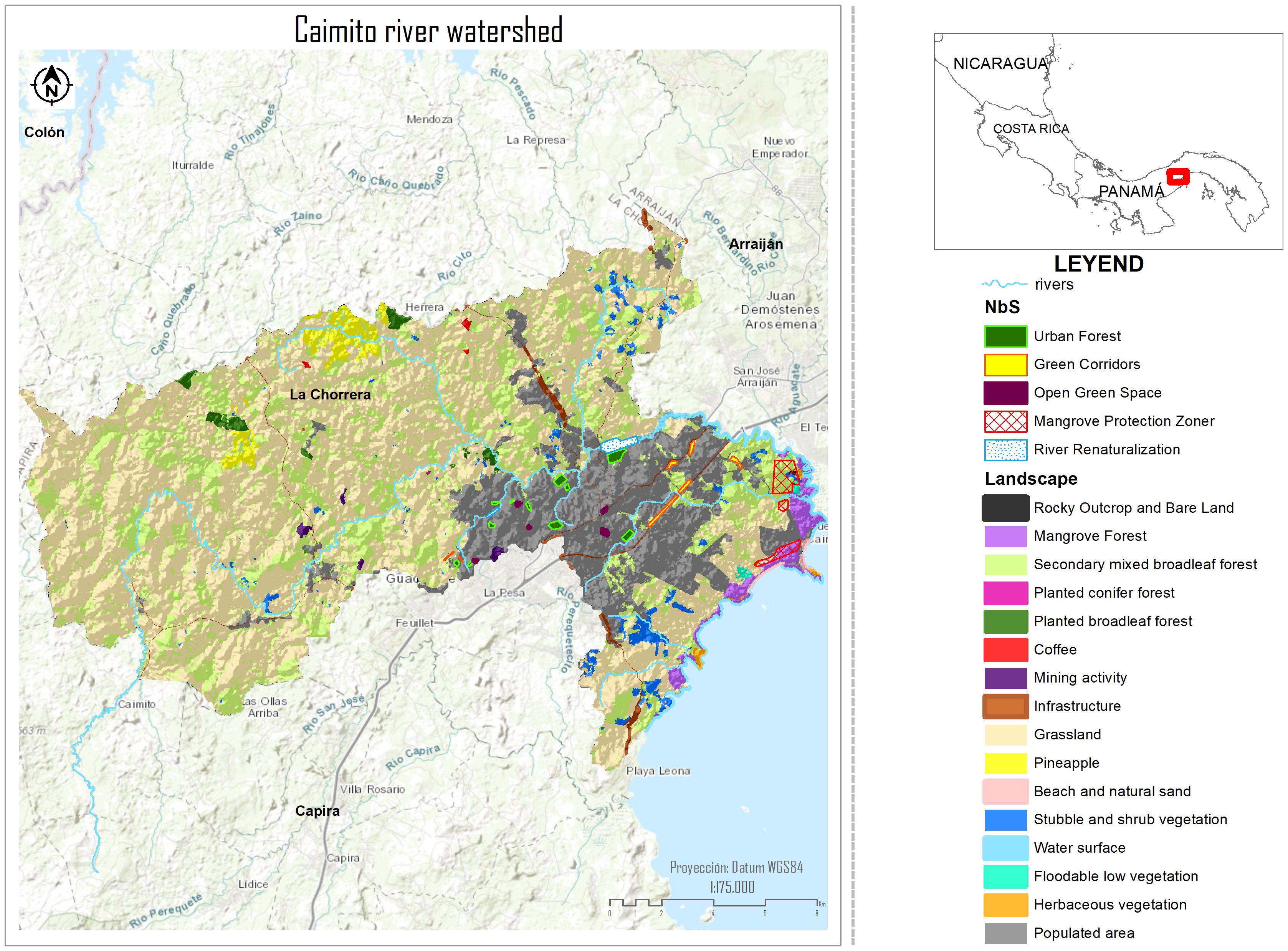
Figure 3. Location of selected NbS in Caimito river watershed, Panamá.
The NbS proposals in El Coyolar were focused on targeted, high-impact zones. Forest Restoration (88%) and Riparian Restoration (82%) addressed specific micro-basins and erosion-prone hillsides. A particularly novel feature is the use of Permeable Pavement, applied to 6.61 linear km of priority urban runoff areas, aimed at reducing surface runoff and supporting aquifer recharge (Figure 4). This case reflects a site-specific, decentralized approach, where NbS interventions are proposed to complement ongoing municipal zoning regulations and urban drainage priorities.
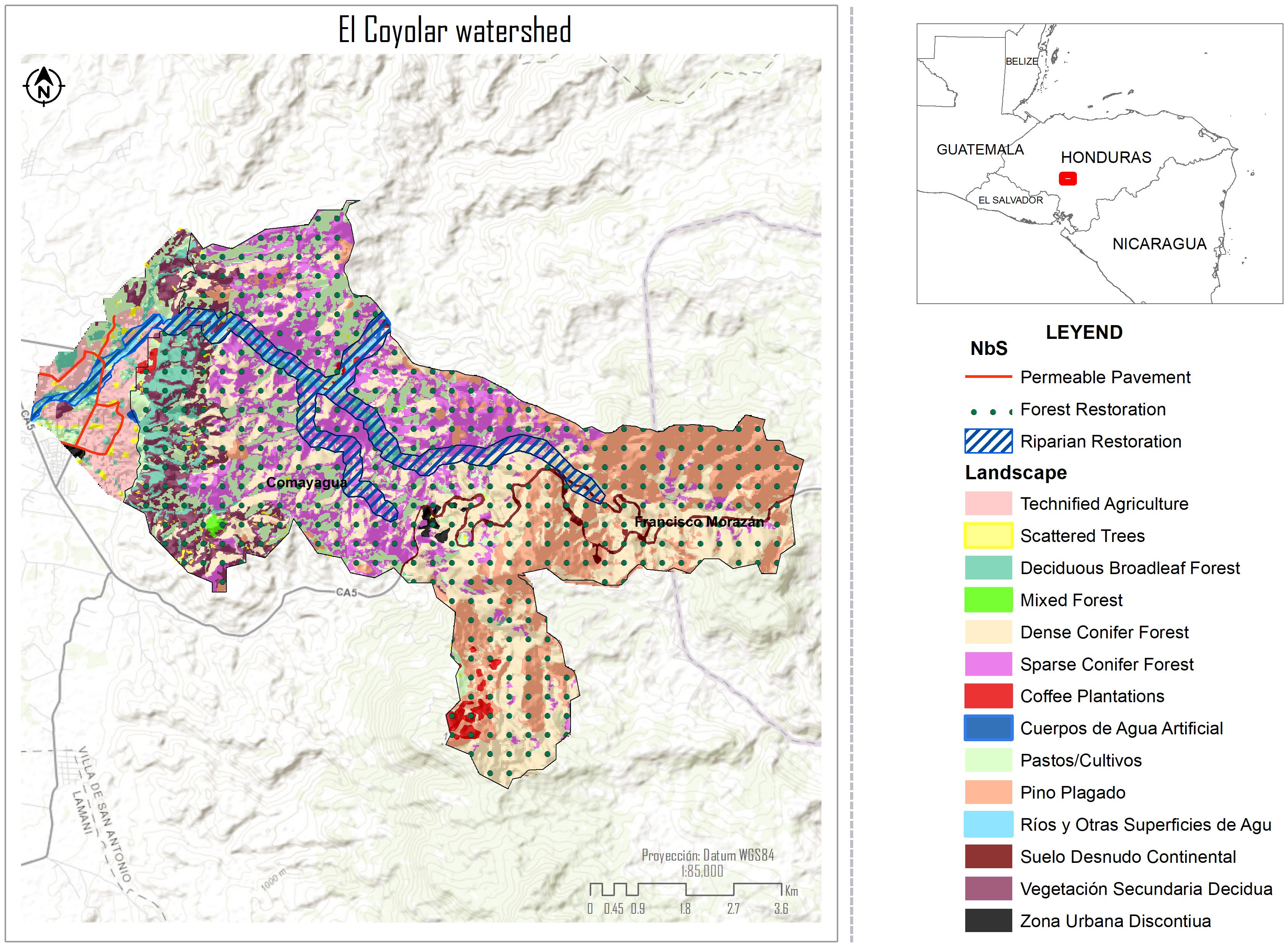
Figure 4. Location of selected NbS in El Coyolar river subwatershed, Honduras.
Overview of stakeholder’s interest and influence to contribute to NbS implementing process
The stakeholder analysis for the implementation of Nature-Based Solutions (NbS) in both the Caimito River watershed and the El Coyolar subwatershed reveals distinct yet complementary governance dynamics that must be considered in planning and execution.
In El Coyolar (Honduras), the institutional landscape is strongly anchored by the Secretariat of Natural Resources and Environment and the Municipal Government of Villa de San Antonio, both of which exhibit high levels of influence and impact. Their presence is essential for setting policy, ensuring legitimacy, and aligning local actions with national environmental priorities. Community-based actors such as Water Boards, Lower Watershed Communities, and the Irrigation District display moderate institutional influence but hold a high degree of impact, particularly in the operational phase of NbS. These groups are embedded in the territory and are crucial for ensuring the long-term maintenance and social legitimacy of interventions. Meanwhile, stakeholders like the Secretariat of Agriculture and Livestock, international cooperation entities (e.g., AECID), and Municipal Emergency Committees have a more specialized or indirect role, offering support functions that can complement implementation if engaged appropriately (Figure 5).
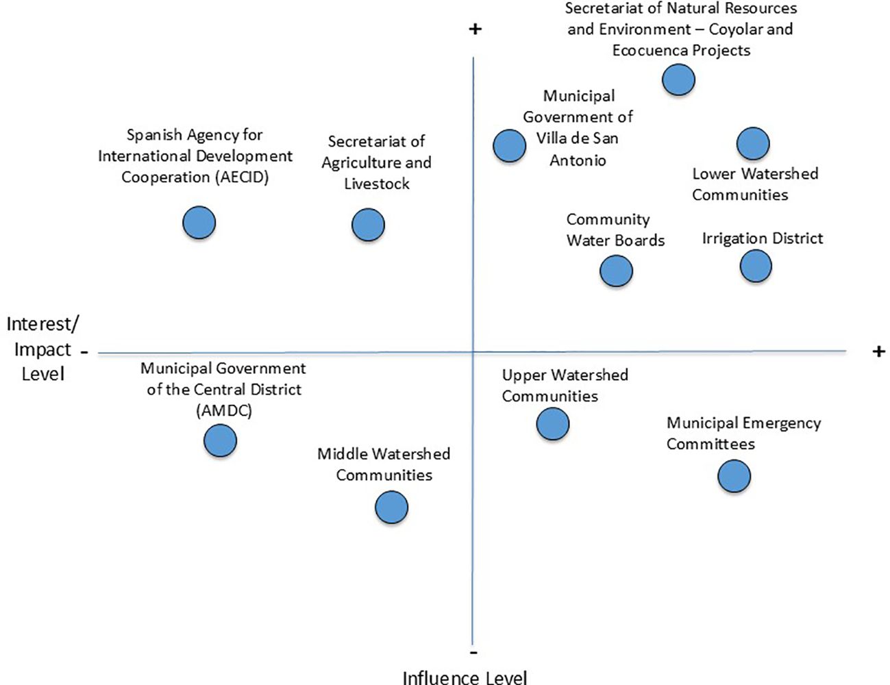
Figure 5. Distribution of key stakeholders in the Interest/Impact and Influence matrix at El Coyolar river subwatershed, Honduras. Authors’ elaboration based on field data. Methodologically adapted from Reed et al. (2009).
In the Caimito River watershed (Panama), the actor configuration reflects a slightly more urban and infrastructure-driven context. MiAMBIENTE and the Municipality of La Chorrera emerge as the most strategic allies due to their combination of high institutional influence and strong interest in environmental action. Other institutions with high influence but moderate interest, such as the Ministry of Public Works (MOP), IDAAN (Water Utility), and the Ministry of Housing (MIVIOT), control key elements of urban planning and infrastructure but may require targeted engagement to prioritize ecosystem-based interventions. On the other hand, actors with high interest but lower influence, including Community Water Committees (JAARS), Local Farmers, and Environmental NGOs, are highly motivated to support NbS but often lack the institutional authority to lead. Notably, Real Estate Developers appear as high-influence yet medium-interest actors, presenting both a challenge and an opportunity for alignment through incentives, awareness, or regulatory mechanisms (Figure 6).
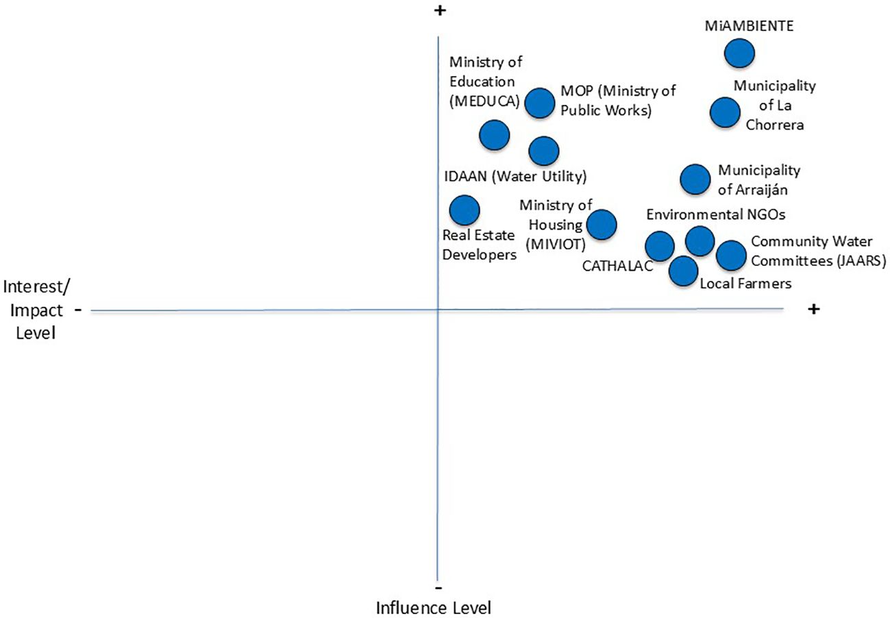
Figure 6. Distribution of key stakeholders in the Interest/Impact and Influence matrix at Caimito river watershed, Panamá.
Across both sites, the analysis highlights a consistent pattern: public institutions and municipalities possess decision-making power, while communities and civil society actors carry the practical and ecological knowledge needed for successful on-the-ground implementation. Effective NbS strategies in these watersheds will therefore depend on building coalitions that connect influence with interest, mobilizing government support while empowering grassroots actors. This dual engagement is critical not only to execute interventions, but to ensure their long-term sustainability and adaptive management.
Implementing pathways for NbS for each study case
El Coyolar subwatershed, Honduras: a community-driven, implementation-centered pathway
The participatory pathway in El Coyolar illustrates how rural NbS implementation hinges on social mobilization and local ownership.
The El Coyolar subwatershed presents a pathway centered on on-the-ground implementation and social mobilization, reflecting a rural and conservation-oriented context. The process begins with a participatory planning phase (P1: P&EC), involving early coordination workshops, drone-based georeferencing, and the creation of suitability maps through soil and vegetation diagnostics. A strong emphasis is placed on community socialization, co-design, and validation of local feedback. This leads into a highly operational second phase (P2: IP), which includes precise demarcation of 52 hectares for forest restoration, seedling production, and a structured planting campaign with local labor.
In addition to reforestation, the pathway addresses erosion control through fencing, riparian buffer delineation (43 ha), debris cleanup, and the planting of native vegetation. Urban-rural interface issues are managed through the identification and engineering design of 6.61 km of permeable pavements, followed by procurement and installation. Phase three (P3: M&U) establishes a participatory monitoring team, measures indicators such as infiltration and vegetative recovery, and builds mechanisms for external evaluation and replication planning (Figure 7).
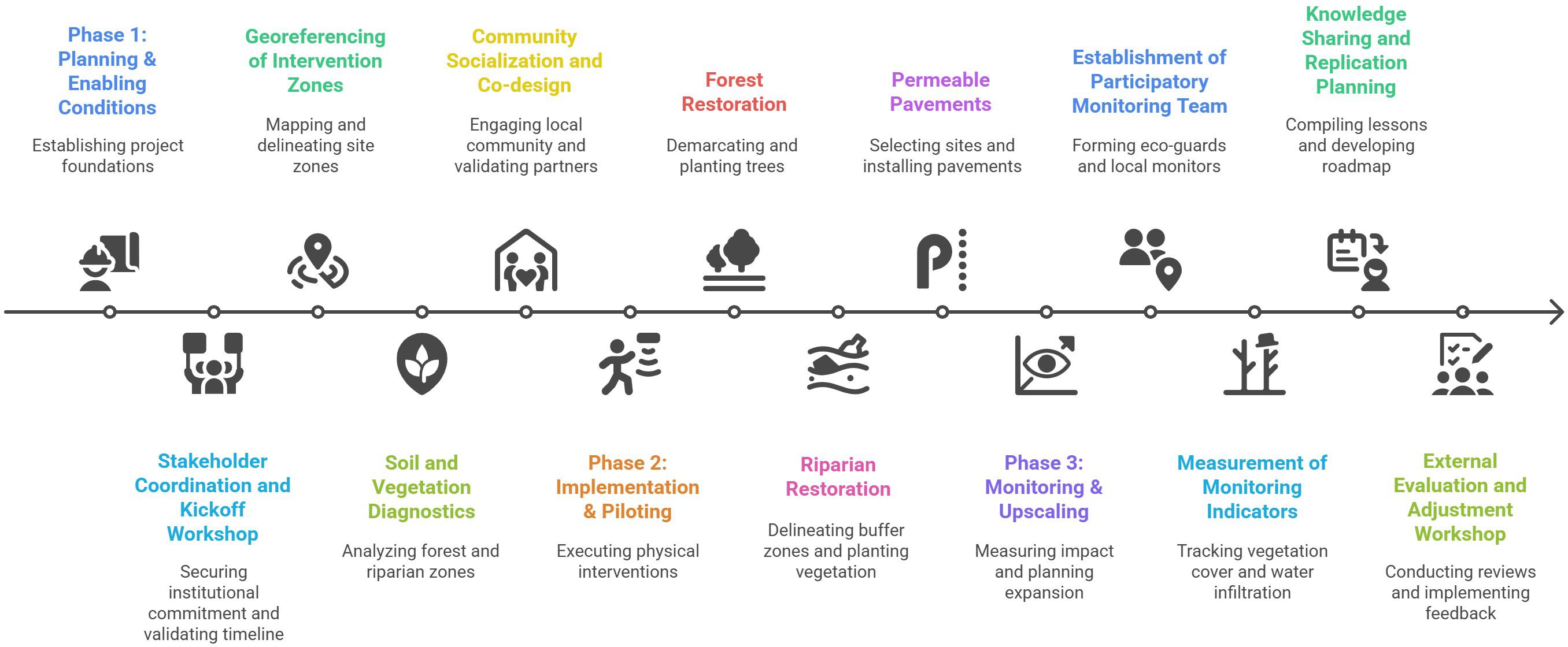
Figure 7. Implementation pathway of selected Nature-based Solutions (NbS) in the El Coyolar subwatershed. Starting with stakeholder coordination and ending with monitoring and evaluation to prepare scaling up.
Caimito river watershed, Panama: a territorial planning and policy-aligned pathway
The implementation pathway designed for the Caimito River watershed is deeply embedded within the institutional and planning frameworks of Panama’s territorial governance. This approach is characterized by a strong emphasis on policy integration, regulatory alignment, and geospatial prioritization. The first phase (P1: DCRA) focuses on validating spatial diagnostics using multisource remote sensing data, including Sentinel-2, ALOS, and SRTM, with particular attention to topographic wetness index (TWI), land use/land cover (LULC), and mangrove presence. With these additional tools and review of our initial identification of NbS allocation, updating and up to date information will be prepared. The pathway incorporates updates to flood and urban expansion risk geoespatial layers in coordination with national agencies like SINAPROC and MiAMBIENTE. Importantly, results are actively integrated into territorial planning instruments such as Municipal Land Use Plans (PMOT by its Spanish Acronym) for La Chorrera and Arraiján. Legal compliance, particularly with RAMSAR and wetland regulations, is a foundational principle.
The second phase (P2: TP–NbS) operationalizes these diagnostics into actionable interventions. NbS are prioritized based on exposure to flood risk and ecological value, with key targets including 165.98 ha of mangrove protection zones, 120 ha for urban forests and green corridors, and 55.88 ha for river renaturalization. The third phase (P3: ICGD) focuses on institutional coordination, including the establishment of an inter-institutional NbS working group comprising MiAMBIENTE, IDAAN, MOP, CATHALAC, and local NGOs. Co-management roles are formalized through MoUs and aligned with decentralization policies. Finally, the fourth phase (P4: E&M) outlines short- and mid-term interventions, including urban micro-park development, mangrove ecosystem reinforcement, and hybridization of grey and green infrastructure, supported by open-source monitoring systems like Google Earth Engine (Figure 8).
Figure 8. Implementation pathway of NbS selected for Caimito river watershed. Starting with diagnostics validation and ending up with monitoring system.
Despite their different territorial contexts and implementation logics, both pathways share important structural and strategic similarities. Each begins with a planning and diagnostic phase grounded in spatial analysis and participatory engagement, ensuring that the interventions are data-informed and socially legitimate. Both approaches include zoning and prioritization based on ecological vulnerability and land-use dynamics, and both emphasize the importance of inter-institutional coordination, whether through formal working groups or co-management arrangements.
Additionally, each case incorporates a clear focus on monitoring, learning, and scalability. While the Caimito case leans more on formal monitoring platforms and municipal integration, El Coyolar emphasizes community-based oversight and local capacity building. Finally, both pathways recognize the critical importance of linking NbS to broader territorial development goals, whether by aligning with regulatory frameworks (Panama) or by strengthening community resilience and governance (Honduras).
Discussion
Pertinence of practical selection of NbS
Our comparative study presents results on the first step toward implementing NbS. Through a geoespatial (GIS, and remote sensing products) analysis and integrating theoretical rationale under selection of NbS, our case studies provide a low-cost preliminary estimation that informs policymakers on the possible NbS to solve their specific main watershed management problems. This practical selection method corresponds to GIS tools employed to identify areas with potential for NBS implementation in the drainage area of a shallow tropical urban lake in Londrina, southern Brazil, where ten NbS were proposed and tested (Alves et al., 2024).
Furthermore, similar parameters to assess watershed (e.g., land use, topography, and land ownership) and community (e.g., demographics, social vulnerability, and social networks) specific characteristics were also used to find suitable locations and ecosystems for large-scale NbS (Seddon et al., 2020; Howarth et al., 2025). Although, our study cases do not include social characteristics within the geoespatial process, we used complementary basic methods to capture social aspects, particularly of stakeholder analysis.
Similarly, the findings of Mubeen et al. (2020), when proposing a GIS-MCA (multicriteria analysis) based methodology to effectively integrate multidisciplinary criteria for spatial suitability assessment of large-scale NbS in a river basin context, tested in a case study Tamnava River basin (746 km²) in Serbia, revealed that nearly all the tools which used similar inputs, including DEM, land use, soil type, imperviousness, groundwater depth, and stream characteristics is part of such identification process of NbS. GIS combined with MCA to evaluate wetland effectiveness under geomorphological, climatological, hydrological, and land use factors was used in the study about a low-cost, preliminary evaluation of wetland effectiveness for nutrient buffering at watershed scale, exemplified with the case study of Grand River, Ontario, Canada (Alamanos and Papaioannou, 2020).
Our methodology is also in line with the tools used to identify potential specific NbS opportunities and sites, conducted to identify areas where NbS, referred to as “FloodWise” practices in the North Carolina Coastal Plain to strategically reduce flooding and provide water quality and habitat improvement. In this case, geospatial analysis in ArcGIS Pro for spatially explicit application of integrated remote sensing, scientific and professional knowledge, and extant databases to screen diverse variables were combined (Baldwin et al., 2022), corresponding to our approach to solve the first stages of selection of potential NbS at watershed levels.
Methodological approaches grounded in multi-criteria analysis integrated with Geographic Information are common even in advanced process like “site selection software (SSS)”, where the different geomorphometric and topo-hydrological factors that we used in our study, were also considered and accounted for to enhance the SSS identification of the best locations for check dams (one type of NbS) including factors of topographic wetness index (TWI), together with terrain ruggedness index (TRI), topographic position index (TPI), sediment transport index (STI), stream power index (SPI), slope, drainage density (DD), and stream order (SO) (Rahmati et al., 2019).
Furthermore, illustrating the data sources and management, coincidences with our practical methodological approach can be found for identification of different target areas where urban flood-related NbS measures can be implemented, mainly using secondary data, including the location of rivers/water bodies, soil texture map, Digital Elevation Model (DEM), and satellite (Landsat) image of the study area together with literature on specific urban flood-related NbS measures (green roofs, vegetated swales, rain gardens, rainwater harvesting, detention basins, and porous pavements), altogether employed to derive desired design conditions in building the NbS measures, with data obtained from government and research institutions, and online platforms, combined with interviews with urban flood management experts to rank the criteria used in the SMCA (Spatial Multi-Criteria Analysis) (Asare et al., 2023). This approach to combine official available data, as well as expert consultation, was a crucial part of our practical methodology to select potential sites for NbS.
Typologies of NbS contributing to build resilient watersheds
The most studied type of nature-based intervention, accounting for around one-third (34%) of studies in the database for scientific literature (386 studies) on the effects of nature-based interventions on climate impacts, involved the establishment or management of created ecosystems (e.g., tree plantations or planting exotic fast-growing grasses). Restoration interventions were the second most reported (29%), followed by management interventions (20%). Combination interventions were reported by 16% of studies, and most (81%) of these included some form of ecosystem protection (Chausson et al., 2020). This type of NbS is also reflected in our study cases, where in both watersheds, it was selected forms of protection (urban forest at Caimito river watershed, and forest restoration at El Coyolar subwatershed).
Regarding the scale of intervention, the selection of watershed scales for our study cases are in line with the findings of the global analysis on the role of NbS on reduction of impacts of natural hazards (Debele et al., 2023), where 92% of the case studies were operationalized at local (50%) and watershed (46%) scales, with 63% of NbS used to deal with natural hazards, climate change, and loss of biodiversity, while the remaining 37% addresses socio-economic challenges (e.g., economic development, social justice, inequality, and cohesion) Also, in line with these global tendencies, our study cases correspond to NbS responding to flood regulation, erosion control and sediment regulation which are related to natural hazards, as one of the equivalent and common NbS selected for both cases.
NbS for water management in peri-urban areas constitute another type of NbS also selected in our study cases. From this category, the systematic review of Ramírez-Agudelo et al. (2020) showed that main selected NbS are wetland-related approaches (natural and constructed), sustainable urban drainage systems (SUDS), and green-roofs/walls, river parks, agroforestry, parks, and permeable pavement, among other types. For our case study in El Coyolar river subwatershed, we found permeable pavements as a suitable peri-urban NbS. Furthermore, the systematic review of Esraz-Ul-Zannat et al. (2023), focused on nature-based infrastructures and their effectiveness for urban flood risk mitigation, found 16 nature-based infrastructures, where the most commonly mentioned NbS infrastructure for urban flood mitigation was green roofs (41%), followed by rain gardens, bioswales, cisterns, and permeable pavements (between 25% and 35%), whereas green streets and blue roofs have the lowest representation, and the rest were below 15% (detention ponds, constructed wetlands, retention ponds, urban agriculture, infiltration trench, riparian buffer, sand filters, urban forest, green walls, green streets). Again, for NbS focused on urban flood risk mitigation, some of our selected NbS are under this typology (urban forest and green streets considered equivalent of green corridors for Caimito river watershed, as well as permeable pavements and riparian buffers as equivalent to riparian restoration for El Coyolar river subwatershed).
Regarding coastal NbS, we identified mangrove protection zone for study case in Caimito river watershed as the major area potentially available for this type of NbS; accordingly, the review of a decade of scientific research on the concept of NbS, focusing on the role of coastal issues found that, among the mentioned coastal ecosystems, mangroves are the most studied habitats, being targets for nature-based and bio inspired strategies in the specific field of coastal protection (Perricone et al., 2023).
Overall, NbS have already proven to be valuable in providing sustainable, cost-effective, multi-purpose and flexible means for hydro-meteorological risk reduction. Nevertheless, the effectiveness, benefits and acceptance of NbS are dependent on the implementation purpose, local context and cultural setting. While small-scale interventions like swales or green roofs are ideal for urban flooding and frequent, low-intensity storms, larger-scale approaches such as river restoration or wetlands are better suited to address riverine and coastal floods, droughts, and landslides, offering broader benefits by integrating multiple functions across wider areas (Ruangpan et al., 2020). In our study cases, we foresee gradual acceptance process, given that our selected NbS also combines small and large scale NbS typology.
Moreover, considering evidence for Latin America and the Caribbean NbS, our case studies follow the tendency of the broad range of NbS financing projects, which had helped to restore and conserve LAC’s forests, grasslands, mangroves, floodplains, riparian ecosystems, coral reefs, urban parks, and bioswales; creating permeable pavements; and encouraging sustainable farming. In this sense, most analyzed projects (80) focused on water quantity, financing forest, agroforestry and silvopastoral systems as their primary strategies, mostly aiming to benefit the water and sanitation sector, with examples in Mexico, Colombia, Peru, or Brazil, but there is still much room for further adoption of NbS (Ozment et al., 2021).
NbS harnesses ecosystems’ inherent resilience and protective qualities to reduce several disaster risk drivers and enhance community resilience, which are also part of LAC challenges, including the restoration of coastal ecosystems such as mangroves and coral reefs, the implementation of green infrastructure systems, and the promotion of agroforestry practices, offering multiple benefits, from reducing coastal erosion and flood risks to improving water management and biodiversity. Finally, NbS provide social and economic co-benefits, such as sustainable livelihoods, improved health outcomes, and enhanced ecosystem services (Lucatello and Alcántara-Ayala, 2024). These evidence-based agreements support our contribution to the practical selection of NbS methods, while highlighting that the next essential steps in the implementation pathway involve the detailed design and mandatory monitoring of their effects and performance.
Implementing NbS under phases
We proposed implementing pathways for selected NbS for each study case, which share a common structure, but reflecting its own specific context. Both begins with a planning and diagnostic phase grounded in spatial analysis and participatory engagement, ensuring that the interventions are data-informed and socially legitimate. Besides, they include zoning and prioritization based on ecological vulnerability and land-use dynamics, and both emphasize the importance of inter-institutional coordination, whether through formal working groups or co-management arrangements.
Similar approach was proposed by Raymond et al. (2017), with seven stages as part of his framework for assessing and implementing the co-benefits of NbS, which include: 1) identification of problem or opportunity; 2) selection and assessment of NbS and related actions; 3) design NbS implementation processes; 4) implementing NbS; 5) frequently engagement of stakeholders and communication of co-benefits; 6) transference and upscale of NbS; and 7) monitoring and evaluation of co-benefits across all stages.
Our implementing pathways are aligned partially with the framework to plan NbS, proposed by Albert et al. (2020), with six steps of planning: (i) co-define setting, (ii) understand challenges, (iii) create visions and scenarios, (iv) assess potential impacts, (v) develop solution strategies, and (vi) realize and monitor. Its implementation is guided by five principles, namely place-specificity, evidence base, integration, equity, and transdisciplinary. From this framework we do not include steps iii and iv, because we rely on existing evidence elsewhere, but also include monitoring as part of impact and specific scenarios to be generated during proper implementation; and from their five principles, we applied the place-specificity.
When comparing our implementation pathways with the conceptual framework proposed by Pérez et al. (2024) for selecting blue NbS, we found strong alignment. Their framework is structured around four progressive steps: (1) identifying the societal challenge(s) to address; (2) recognizing relevant ecosystem services and the underlying biodiversity and ecological functions that can help meet those challenges; (3) defining the environmental context of the intervention—including spatial scale, ecosystem vulnerability, and ecological condition; and (4) selecting suitable blue NbS interventions tailored to the defined context. Although monitoring is not explicitly addressed in their framework—as it is in ours—the general approach is consistent. Moreover, our selected NbS adhere to the design principles of maintaining, enhancing, restoring, or creating ecosystem services through support for biodiversity. The intervention portfolio in Pérez et al. (2024) includes marine protection, restoration actions, and regulatory measures, which align closely with the objectives of our proposed NbS.
Governance and watershed planning instruments for effective NbS adoption
Across our two study sites, public institutions and municipalities possess decision-making power, while communities and civil society actors carry the practical and ecological knowledge needed for successful on-the-ground implementation. Effective NbS strategies in these watersheds will therefore depend on building coalitions that connect influence with interest, mobilizing government support while empowering grassroots actors. This dual engagement is critical not only to execute interventions, but to ensure their long-term sustainability and adaptive management. Moreover, we propose that results of implementing NbS must be actively integrated into territorial planning instruments such as PMOTfor La Chorrera and Arraiján, together with legal compliance, particularly with RAMSAR and wetland regulations in Panamá. Similarly, the existing Villa de San Antonio Municipal Development Plan, which already incorporates a territorial planning perspective. As Longato et al. (2024) observe, although urban planning has long acknowledged the value of green spaces, older municipal plans often fail to reflect the full potential of greening interventions or the policy tools available to scale them effectively, underscoring the need to revise and update these instruments in light of NbS strategies.
Our findings regarding governance and institutional instruments are consistent with trends reported in the literature. For instance, a global analysis by Debele et al. (2023) found that approximately 88% of NbS implementations are supported by national-level policies, while only 12% are grounded in local or regional frameworks. In the case studies we examined (Panama and Honduras), governance and management of NbS were observed to operate across multiple territorial scales, including municipal, metropolitan, and watershed levels. These interventions frequently required cross-jurisdictional coordination and were enabled through formal agreements and policy instruments, in line with observations from Ramírez-Agudelo et al. (2020).
Moreover, integrating NbS into land-use planning frameworks and regulatory instruments can significantly enhance their implementation. This potential increases further when socio-environmental justice and social cohesion are considered, particularly through integrated governance approaches that promote inclusive and transdisciplinary participation from diverse stakeholders (Kabisch et al., 2016). Our stakeholder analysis supports this perspective, revealing the predominant role of public authorities in steering implementation processes, though other actors—such as academia and industry—also play meaningful roles in some contexts (Ramírez-Agudelo et al., 2020). To support effective implementation, it is crucial to recognize key governance enablers of NbS, including polycentric governance structures that engage multiple institutional scales and sectors; co-design processes that ensure stakeholder participation influences NbS design; advocacy from pro-NbS coalitions; and financial mechanisms that support community-led implementation and monitoring. Additionally, the ability of NbS to contribute to multiple global agendas—such as disaster risk reduction (DRR), climate change adaptation, and sustainable development—underscores their relevance across all phases of the implementation pathways examined in our study cases (Martin et al., 2021).
Overall, our results contribute with the value of operationalizing NbS principles 2 “NbS can be implemented alone or in an integrated manner with other solutions to societal challenges, 6 “NbS are applied at a landscape scale”, such as watersheds, and 8 “NbS are an integral part of the overall design of policies, and measures or actions, to address a specific challenge, which will enable us to address societal challenges at the scale needed. This will necessitate a high degree of coordination amongst stakeholders, including the public and private sectors (Cohen-Shacham et al., 2019).
Conclusion
This study demonstrates how tailored Nature-based Solutions (NbS) pathways can effectively address watershed degradation and climate vulnerability when grounded in spatial diagnostics, local participation, and multiscale governance. In both case studies—El Coyolar in Honduras and Caimito in Panama—NbS implementation was shaped by contextual factors, with success hinging on community engagement, institutional coordination, and alignment with territorial planning instruments. The results highlight the value of participatory design and governance structures that span administrative boundaries, offering replicable models for scaling NbS in Latin America and beyond.
Data availability statement
The original contributions presented in the study are included in the article/supplementary material, further inquiries can be directed to the corresponding author/s.
Author contributions
LB: Conceptualization, Funding acquisition, Investigation, Methodology, Supervision, Writing – original draft, Writing – review & editing. NR: Writing – review & editing, Methodology, Supervision, Investigation, Visualization. LF: Conceptualization, Formal analysis, Investigation, Methodology, Visualization, Writing – review & editing. CM: Conceptualization, Formal analysis, Investigation, Methodology, Visualization, Writing – review & editing. OI: Conceptualization, Investigation, Methodology, Supervision, Writing – review & editing.
Funding
The author(s) declare financial support was received for the research and/or publication of this article. Institutional funds from the Unit of watershed, water security and soils-CATIE (08-02-06-003) support the work of the authors.
Acknowledgments
To Héctor Mojica for academic advice, to MiAMBIENTE, SERNA, and local municipal teams for providing key data and facilitating technical coordination. Appreciation goes to community members and stakeholders in La Chorrera and Villa de San Antonio for their collaboration during participatory activities, and to Adania Matus for the support in maps edition.
Conflict of interest
The authors declare that the research was conducted in the absence of any commercial or financial relationships that could be construed as a potential conflict of interest.
Generative AI statement
The author(s) declare that Generative AI was used in the creation of this manuscript. For the preparation of this work, the authors used ChatGPT AI (ChatGPT 4o), and Napkin AI tools for the purpose of enhancing the language and readability of the text, as well as for visual diagrams-synthesis. After using this tool, the authors reviewed and edited the content as needed, assuming full responsibility for the publication’s content.
Any alternative text (alt text) provided alongside figures in this article has been generated by Frontiers with the support of artificial intelligence and reasonable efforts have been made to ensure accuracy, including review by the authors wherever possible. If you identify any issues, please contact us.
Publisher’s note
All claims expressed in this article are solely those of the authors and do not necessarily represent those of their affiliated organizations, or those of the publisher, the editors and the reviewers. Any product that may be evaluated in this article, or claim that may be made by its manufacturer, is not guaranteed or endorsed by the publisher.
Supplementary material
The Supplementary Material for this article can be found online at: https://www.frontiersin.org/articles/10.3389/fcosc.2025.1640398/full#supplementary-material
References
Alamanos A. and Papaioannou G. (2020). A spatial multi-criteria decision analysis approach for identifying suitable areas for implementing nature-based solutions in urban catchments. Sustainability 12, 7493. doi: 10.3390/su12187493
Albert C., Schröter B., Haase D., Brillinger M., Henze J., Herrmann S., et al. (2020). Addressing societal challenges through nature-based solutions: How can landscape planning and governance research contribute? Landscape Urban Plann. 202, 103942. doi: 10.1016/j.landurbplan.2020.103942
Alves A., Mellin M., Kabisch N., Lenz R., Baró F., Davidse B. J. S., et al. (2024). Assessing urban nature-based solutions using geospatial indicators: A systematic review. Ecol. Indic. 158, 112908. doi: 10.1016/j.ecolind.2023.112908
Asare B., Addae C., Forkuo E. K., Agyei E. K., and Adjei K. A. (2023). Mapping the suitability of nature-based solutions for flood risk reduction using geospatial techniques in a rapidly urbanizing watershed. J. Environ. Manage. 330, 117205. doi: 10.1016/j.jenvman.2022.117205
Baldwin E., van Teeffelen A. J. A., Väänänen E., Di Marino M., López-Gunn E., and Geneletti D. (2022). Nature-based solutions for climate adaptation: A review of EU-funded research projects. Environ. Sci. Policy 127, 34–43. doi: 10.1016/j.envsci.2021.10.021
Baumann J. and Jaco R. (2024). Los suelos en las estaciones experimentales de la DICTA, Honduras: Caracterización y evaluación de sus propiedades físicas y químicas. (Cali: Alianza Bioversity International y CIAT/DICTA). 200 pp.
Caballero C., Del Cid J., Gómez K., Felix L., Lewis L., and Lewis S. (2013). Plan de Manejo de la Cuenca del Rio Caimito (Sede Chiriquí: Universidad de Panamá, Facultad de Ciencias Agropecuarias).
Chausson A., Turner B., Seddon D., Chabaneix N., Girardin C. A. J., Kapos V., et al. (2020). Mapping the effectiveness of nature-based solutions for climate change adaptation. Global Change Biol. 26, 6134–6155. doi: 10.1111/gcb.15310
Chevalier J. M. and Buckles D. J. (2013). Participatory action research: theory and methods for engaged inquiry (London: Routledge). doi: 10.4324/9780203107386
Cohen-Shacham E., Walters G., Janzen C., and Maginnis S. (Eds.) (2016). Nature-based Solutions to address global societal challenges (Gland, Switzerland: IUCN). doi: 10.2305/IUCN.CH.2016.13.en
Cohen-Shacham E., Walters G., Janzen C., and Maginnis S. (2019). Nature-based solutions to address global societal challenges (Gland, Switzerland: IUCN). Available online at: https://portals.iucn.org/library/node/49070.
Debele S. E., Jayasinghe G., Abebe Y. A., Moulds S., Fuldauer L. I., Westra S., et al. (2023). Nature-based solutions for urban flood risk management: A global evidence review. Sci. Total Environ. 866, 161266. doi: 10.1016/j.scitotenv.2023.161266
Esraz-Ul-Zannat M., Hasan M. R., Dewan A., Mukherjee N., Mahmud M. S., and Rahman M. S. (2023). A systematic review of nature-based solutions for urban flood risk management: Challenges and opportunities. Urban Climate 47, 101391. doi: 10.1016/j.uclim.2022.101391
FAO (Food and Agriculture Organization of the United Nations) (2023). SoilFER: Mapping soils for resilient agri-food systems in Honduras (David, Panamá; FAO Global Soil Partnership). Available online at: https://www.fao.org/global-soil-partnership/resources/highlights/detail/en/c/1657167.
Frantzeskaki N., McPhearson T., Collier M. J., Kendal D., Bulkeley H., Dumitru A., et al. (2019). Seven lessons for planning nature-based solutions in cities. Environ. Sci. Policy 93, 101–111. doi: 10.1016/j.envsci.2018.12.033
GWP Central America (2021). Plan de acción para la gestión integrada de los recursos hídricos de la cuenca del río Choluteca (Tegucigalpa: Global Water Partnership Centroamérica). Available online at: https://www.gwp.org/globalassets/global/gwp-cam_files/pac-rio-choluteca_lowres.pdf (Accessed February 20, 2025).
Howarth C., Liniger H. P., Krummenacher B., Eekhout J. P. C., Schwilch G., Noellemeyer E., et al. (2025). Nature-based solutions for climate-resilient land and water management: What works, where and why? Environ. Sci. Policy 146, 125–139. doi: 10.1016/j.envsci.2023.12.008
Instituto Nacional de Estadística y Censo (INEC) (2010). Estimación y proyección de la población del distrito de Arraiján, por corregimiento, según sexo y edad: años 2010–2020. (Panamá: Contraloría General de la República de Panamá). Available online at: https://www.contraloria.gob.pa/inec/archivos/P5561Cuadro%2050.pdf (Accessed September 26, 2025). [In Spanish]
IPBES (2019). Summary for policymakers of the global assessment report on biodiversity and ecosystem services of the Intergovernmental Science-Policy Platform on Biodiversity and Ecosystem Services. Eds. Díaz S., Settele J., Brondízio E. S., Ngo H. T., Guèze M., Agard J., Arneth A., Balvanera P., Brauman K. A., Butchart S. H. M., Chan K. M. A., Garibaldi L. A., Ichii K., Liu J., Subramanian S. M., Midgley G. F., Miloslavich P., Molnár Z., Obura D., Pfaff A., Polasky S., Purvis A., Razzaque J., Reyers B., Chowdhury R.R., Shin Y. J., and Visseren-Hamakers I. J. (Bonn, Germany: IPBES secretariat). doi: 10.5281/zenodo.3831673
JICA (Japan International Cooperation Agency) (2008). The study on watershed management and flood control for the Tegucigalpa river basin in the Republic of Honduras: Final report (Tokyo: Yachiyo Engineering Co., Ltd). Available online at: https://openjicareport.jica.go.jp/pdf/11688421_16.pdf.
Kabisch N., Frantzeskaki N., Pauleit S., Naumann S., Davis M., Artmann M., et al. (2016). Nature-based solutions to climate change mitigation and adaptation in urban areas: perspectives on indicators, knowledge gaps, barriers, and opportunities for action. Ecol. Soc. 21, 39. doi: 10.5751/ES-08373-210239
Locatelli B., Pavageau C., Pramova E., and Di Gregorio M. (2015). Integrating climate change mitigation and adaptation in agriculture and forestry: opportunities and trade-offs. Wiley Interdiscip. Reviews: Climate Change 6, 585–598. doi: 10.1002/wcc.357
Longato D., Frantzeskaki N., van Meerkerk I., and Mees H. (2024). Navigating the governance of nature-based solutions: Learning from real-life experiments across Europe. Environ. Sci. Policy 150, 117–128. doi: 10.1016/j.envsci.2023.12.010
Lucatello S. and Alcántara-Ayala I. (2024). Nature-based solutions in Latin America and the Caribbean: Potential and limitations for disaster risk reduction. Environ. Sci. Policy 150, 107–116. doi: 10.1016/j.envsci.2023.12.009
Martin J. G. C., Scolobig A., Linnerooth-Bayer J., Liu W., and Balsiger J. (2021). Catalyzing innovation: Governance enablers of nature-based solutions. Sustainability 13, 1971. doi: 10.3390/su13041971
Millennium Ecosystem Assessment (2005). Ecosystems and human well-being: synthesis (Washington, DC: Island Press). Available online at: https://www.millenniumassessment.org/en/Synthesis.html (Accessed April 30, 2025).
Meerow S. and Newell J. P. (2017). Spatial planning for multifunctional green infrastructure: Growing resilience in Detroit. Landsc. Urban Plan. 159, 62–75. doi: 10.1016/j.landurbplan.2016.10.005
Mubeen M., Yaseen Z. M., Baral H., Murtaza G., Gebre S. L., and Kisi O. (2020). Evaluating nature-based solutions for flood risk reduction using hydrological modeling and GIS: A case study from Pakistan. Sci. Total Environ. 731, 139082. doi: 10.1016/j.scitotenv.2020.139082
Narayan S., Beck M. W., Wilson P., Thomas C. J., Guerrero A., Shepard C. C., et al. (2017). The value of coastal wetlands for flood damage reduction in the northeastern USA. Sci. Rep. 7, 9463. doi: 10.1038/s41598-017-09269-z
Ozment S., DiFrancesco K., and Gartner T. (2021). Natural infrastructure: investing in forested landscapes for source water protection in the United States (Washington, DC: World Resources Institute). Available online at: https://www.wri.org/research/natural-infrastructure.
Palomo I., Locatelli B., Otero I., Colloff M. J., Crouzat E., Cuni-Sanchez A., et al (2021). Assessing nature-based solutions for transformative change. One Earth 4, 730–741. doi: 10.1016/j.oneear.2021.04.013
Pérez M. E., Rodríguez-Rojas M. I., Martínez B., and Gámez L. E. (2024). Prioritizing nature-based solutions for watershed management in tropical regions: A multi-criteria GIS-based approach. Ecol. Eng. 196, 107001. doi: 10.1016/j.ecoleng.2023.107001
Perricone E., Geneletti D., Vero S., and De Lotto R. (2023). A spatial multi-criteria approach for assessing nature-based solutions in urban planning: Application to a Latin American city. Environ. Impact Assess. Rev. 100, 107006. doi: 10.1016/j.eiar.2023.107006
Rahmati O., Zeinivand H., and Besharat M. (2019). Flood hazard zoning using a combination of analytical hierarchy process (AHP) and frequency ratio (FR) models in GIS environment. Int. J. Environ. Sci. Technol. 16, 4875–4886. doi: 10.1007/s13762-018-2063-3
Ramírez-Agudelo C. A., Quintero-Angel M., and Moreno N. J. (2020). Nature-based solutions for water management in Colombia: Challenges and opportunities in policy, governance and implementation. Sustainability 12, 8893. doi: 10.3390/su12218893
Raymond C. M., Frantzeskaki N., Kabisch N., Berry P., Breil M., Nita M. R., et al. (2017). A framework for assessing and implementing the co-benefits of nature-based solutions in urban areas. Environ. Sci. Policy 77, 15–24. doi: 10.1016/j.envsci.2017.07.008
Reed M. S., Graves A., Dandy N., Posthumus H., Hubacek K., Morris J., et al. (2009). Who’s in and why? A typology of stakeholder analysis methods for natural resource management. J. Environ. Manage. 90, 1933–1949. doi: 10.1016/j.jenvman.2009.01.001
Rodríguez Cruz G. O. (2022). Calidad del agua para consumo humano y protección de la vida acuática en el embalse Los Laureles de Tegucigalpa (2002–2016). Rev. Cienc. Ambient. 56 (1), 138–156. doi: 10.15359/rca.56/1.7Available online at: scielo.sa.cr [In Spanish].
Ruangpan L., Vojinovic Z., Di Sabatino S., Leo L. S., Capobianco V., Oen A. M. P., et al. (2020). Nature-based solutions for hydro-meteorological risk reduction: A state-of-the-art review of the research area. Natural Hazards Earth System Sci. 20, 243–270. doi: 10.5194/nhess-20-243-2020
Seddon N., Chausson A., Berry P., Girardin C. A. J., Smith A., and Turner B. (2020). Understanding the value and limits of nature-based solutions to climate change and other global challenges. Philos. Trans. R. Soc. B: Biol. Sci. 375, 20190120. doi: 10.1098/rstb.2019.0120
Simmons C. S. and Castellanos M. (1969). Informe al Gobierno de Honduras sobre los suelos de Honduras (Prog. UNDP n. AT 2630) (Roma: Food and Agriculture Organization of the United Nations).
UNESCO World Water Assessment Programme (2018). The united nations world water development report 2018: nature-based solutions for water (Paris: UNESCO). Available online at: https://www.unesco.org/en/wwap/wwdr/2018 (Accessed April 30, 2025).
Verdone M. and Seidl A. (2017). Time, space, place, and the Bonn Challenge global forest restoration target. Restor. Ecol. 25, 903–911. doi: 10.1111/rec.12512
Vogl A. L., Goldstein J. H., Daily G. C., Vira B., Bremer L. L., McDonald R. I., et al. (2017). Mainstreaming investments in watershed services to enhance water security: Barriers and opportunities. Environ. Sci. Policy 75, 19–27. doi: 10.1016/j.envsci.2017.05.007
Wendling L. A., Huovila A., zu Castell-Rüdenhausen M., Hukkalainen M., and Airaksinen M. (2018). Benchmarking nature-based solution and smart city assessment schemes against the sustainable development goal indicator framework. Front. Environ. Sci. 6, 69. doi: 10.3389/fenvs.2018.00069
Keywords: water resource management, climate resilience, community and stakeholders engagement, sustainable land use, governance
Citation: Benegas L, Ríos Ramírez N, Fino Rodríguez LI, Mosquera Ballejos CF and Ibáñez López O (2025) Integrating nature-based solutions for resilient watershed management: a comparative study in urban and semi-urban watersheds of Panama and Honduras. Front. Conserv. Sci. 6:1640398. doi: 10.3389/fcosc.2025.1640398
Received: 03 June 2025; Accepted: 03 September 2025;
Published: 24 October 2025.
Edited by:
Emilia Cruz-Li, National Autonomous University of Honduras, HondurasReviewed by:
Jose Fabrega Duque, Technological University of Panama, PanamaKuldeep Singh Rautela, Indian Institute of Technology Indore, India
Copyright © 2025 Benegas, Ríos Ramírez, Fino Rodríguez, Mosquera Ballejos and Ibáñez López. This is an open-access article distributed under the terms of the Creative Commons Attribution License (CC BY). The use, distribution or reproduction in other forums is permitted, provided the original author(s) and the copyright owner(s) are credited and that the original publication in this journal is cited, in accordance with accepted academic practice. No use, distribution or reproduction is permitted which does not comply with these terms.
*Correspondence: Laura Benegas, bGF1cmEuYmVuZWdhc0BjYXRpZS5hYy5jcg==
†ORCID: Laura Benegas, orcid.org/0000-0002-1890-0213