Abstract
River sedimentation has emerged as a critical driver of water scarcity in semi-arid regions, yet most studies neglect sediment accumulation on riverbeds. This study investigates the magnitude, economic implications, and community adaptations to fluvial sedimentation in the Lower Lusitu River Channel, southern Zambia. A mixed-methods approach was used, combining geomorphological field sampling with qualitative focus group discussions across a 15 km downstream channel stretch. Sediment depth was measured at 68 points using a Graduated Sediment Depth (GraSeD) rod, spatially analyzed via the ArcMap 10.4 Inverse Weighted Distance interpolation plugin and further analyzed using polynomial regression. A novel participatory suitability rating of river sand and market data was used to estimate the economic value of sediment. Qualitative data were analyzed using thematic analysis. Results indicate that 2.86 million m3 (4.64 million tons) of sand, approximately equating to 68.34% of the original channel depth, occupied the riverbed, drastically limiting surface water flow. We argue that while the river appears dry from July to December, interstitial water persists throughout, supporting basic household and agricultural needs through 56 community-built wells, pools, and sand reservoirs on the riverbed. Socioeconomically privileged households utilize pumps and plastic container–reinforced wells, whereas poorer households rely on labor-intensive manual fetching. Notwithstanding the fact that interstitial water provides an alternative source of water during the water-stressful period from July to early December, health risks to about 20,000 people in 1,073 households with over 30,000 livestock, potential human–livestock conflicts, and inequities in water access are prevalent. Despite these challenges, the sediment's estimated market value of USD 11.2 million, based on a suitability score of 0.652, presents an underexplored economic opportunity. This study provides empirical evidence that sediment acts as both a barrier to water access and a potential economic asset. It challenges the notion of the Lusitu River as a seasonally dry river by demonstrating sustained subsurface hydrological activity through interstitial water. The findings highlight the potential for policy reform to legalize community-built water infrastructure and regulate sustainable sand extraction. Integrating community resilience strategies with sediment management could enhance water security and livelihoods in similar river systems facing sediment-induced water scarcity and stress.
Highlights
-
This study provides the first estimate of in-channel sediment in the Lusitu River, over 2.86 million m3 (4.64 million tons), filling 68% of the channel depth and driving water scarcity.
-
The river exhibits a dual hydrological regime: surface flow lasts one-third of the year, with subsurface flow sustaining year-round access via shallow wells and sand reservoirs.
-
Water access is deeply unequal: over 85% of residents rely on hand-dug wells, while wealthier households use reinforced wells and pumps.
-
The sediment has an estimated economic value exceeding USD 11 million (PSR = 0.652), indicating the potential for sediment management to support both water resilience and livelihoods.
-
A replicable sediment valuation framework is introduced, alongside a call for formal recognition of community-built water systems to guide integrated governance in semi-arid rivers.
1 Introduction
Globally, fluvial sedimentation is a major driver of river morphological changes and it directly affects water availability and scarcity (Garvey and Whiles, 2023). While recent studies have made significant technical advances in modeling and predicting sedimentation, they often neglect the social and ecological dimensions of sediment dynamics. For example, Sharma et al. (2025) developed a remote sensing and machine learning framework to simulate fluvial sediment pulses, leveraging satellite imagery and physically informed predictors to fill data gaps in turbidity reconstruction. However, this study and similar technically focused efforts overlook the critical human and ecological implications of sedimentation. While we appreciate the study by Tipper et al. (2025) about continental sediment geochemistry, especially in river sediments in the form of crustal evolution and geomorphology, it overly focused on the geophysical process highlighting the significant roles of sediment provenance, hydrodynamic sorting, and chemical weathering, stressing the importance of accounting for sorting effects to properly interpret weathering signals and source compositions in sedimentary records. It barely links the findings to anthropogenic processes notwithstanding that human activities such as urbanization, industrialization, and agricultural expansion have substantially accelerated sedimentation in river systems worldwide (Hasan et al., 2024).
The study by Hasan et al. (2024) in the Arial Khan River Basin of Bangladesh highlights significant net loss of land from 1993 to 2024 due to erosion outpacing accretion, showing how riverbank erosion and accretion dynamics significantly affect local land use and water bodies. However, the study does not explicitly link these morphological and land use and land cover changes to human water scarcity issues. The paper misses the opportunity to address how river morphology affects water availability, quality, and access for surrounding populations. While normalized difference vegetation index analyses highlight vegetation health, the study lacks discussion about the implications for freshwater resource sustainability or drinking water supply. Our study could potentially bridge this gap as it integrates river sedimentation with water scarcity challenges and socioeconomic impacts on human populations that rely on river systems. In the Amazon River Basin, sedimentation rates ranging from 0.04 to 1.02 cm/year have been attributed to anthropogenic drivers over the past five decades (Ferreira et al., 2013). Such impacts are not isolated given that similar sedimentation challenges have been documented in the lower Yellow River (Qin et al., 2011; Xu, 2002) and river systems in Myanmar and Brazil (Zaw and Intralawan, 2014). Another study highlighted global hotspots of sediment transport, noting particularly high suspended sediment yields in regions such as East Africa and western South America. However, most of these studies emphasize suspended sediment transport rather than the in-channel sediment accumulation that directly alters riverbed morphology and ecosystem functions (Tundu et al., 2018).
Recent studies have emphasized the critical impact of anthropogenic and climatic factors on riverine sedimentation and ecosystem dynamics. Woo et al. (2023) investigated the four Major Rivers Restoration Project in South Korea, highlighting how large-scale river engineering interventions such as dredging and weir construction triggered unintended sediment redistribution, tributary headcuts, and downstream scouring. Their findings highlighted the necessity for integrated, watershed-scale sediment management to address these challenges. In the Ethiopian context, Mulatu et al. (2024) employed the SWAT model to examine the geomorphic and ecological consequences of land use change in the Upper Blue Nile Basin. Their study revealed a 49% increase in sediment yield from 1985 to 2021 due to forest decline and agricultural expansion, identifying northwestern sub-watersheds as critical erosion hotspots. Complementing this, Tikuye et al. (2023) integrated spatial modeling with climate projections to assess sediment and nutrient export in the Lake Tana Basin. They reported a 60.5% rise in sediment export and projected further increases under future climate scenarios (RCP4.5 and RCP8.5), recommending targeted conservation in vulnerable areas. Collectively, these studies illustrate that both engineered interventions (Woo et al., 2023) and land use transitions (Mulatu et al., 2024; Tikuye et al., 2023) exacerbate sedimentation risks (Engdaw et al., 2025). While Woo et al. (2023) focus on structural solutions, the Ethiopian studies advocate for nature-based watershed planning. A key gap remains in the determination of the actual amount of sediment accumulating on riverbeds along with the respective implications regarding water availability, which integrate interdisciplinary approaches that unify hydrological principles with community-based riverine water management and conservation perspectives.
In Zambia, sedimentation studies have largely centered on reservoir siltation and basin-wide erosion, as highlighted by Simweene and Muchanga (2021), Muchanga and Mafwabo (2025), and (Hamatuli and Muchanga, 2021). These works emphasize catchment-scale sediment sources and transport, providing important insights into how land use, deforestation, and rainfall patterns drive sediment yield and deposition in downstream reservoirs and floodplains. However, in-channel sedimentation processes such as riverbed aggradation, bar formation, and channel infilling have received far less attention except in recent study by Muchanga and Mafwabo (2025), which also focused on granulometric analysis of fluvial sediment without explicit linkage to water scarcity. The Luangwa and Zambezi Rivers exemplify this similar research gap. While these rivers are recognized for their high sediment transport capacities, studies have primarily measured suspended sediment loads and bank erosion, rather than direct bed-level changes or sediment storage within the channel itself (Sichingabula et al., 2022). As such, the actual rates and spatial variability of riverbed sediment accumulation remain undocumented. Similarly, the Chongwe River study by Chisola and Kuraz (2016) raised concerns about sediment loads' impacts on the river, but their analysis was limited to suspended sediment concentrations and basin erosion, short of quantifying the extent of in-channel sedimentation or the dynamics of sediment redistribution within the channel.
A study similar to that by Muchanga and Mafwabo (2025) illustrates the gravity of sedimentation in the Magoye River and showed how granulometric characteristic of sediment influence human activities on the river bed but does not clearly link the findings to water scarcity within the wider context of the basin. Despite extensive global and regional research on suspended sediment transport and catchment-wide erosion, there remains a critical underrepresentation of studies that quantify in-channel sediment accumulation and its direct impacts on water scarcity, particularly in African river systems. Processes such as riverbed aggradation, bar formation, and channel infilling fundamentally reshape river morphology and degrade water availability yet are often overlooked in favor of suspended load assessments or granulometric analyses. This gap limits fluvial geomorphologists' ability to fully understand the feedback between sediment deposition and river hydrology, especially in socioecologically vulnerable contexts. In Zambia, for instance, key rivers such as the Luangwa, Zambezi, and Lusitu suffer from data deficiencies on spatial sediment storage and its consequences for water access and ecosystem function. Addressing this gap with integrated geomorphological, hydrological, and socioeconomic approaches is essential for advancing river science and informing sustainable river basin management under increasing anthropogenic and climatic pressures. In our view, this constituted a problem for our study which aimed at bridging this gap by providing empirical insights into how in situ sedimentation in the lower Lusitu River, southern Zambia, exacerbates water scarcity and socioeconomic challenges in affected communities, including the coping mechanism of the local communities.
The specific objectives of the study were to quantify in-channel sedimentation, assess the community coping strategies to water scarcity, and examine the potential financial value of the accumulated sandy sediment. The study provides globally significant insights by redefining “seasonally dry” rivers through subsurface flow persistence, introducing a scalable sediment valuation framework, and integrating hydrological and socioeconomic dimensions. These findings offer a replicable framework for sustainable water and sediment management in semi-arid, sandy-bedded river systems worldwide.
2 Description of study area
The Lusitu River Catchment covers an area of about 1,831 km2. Its geographical location lies between 16°05′00"S to 16°25′00"S and 28°10′00"E to 28°50′00"E (Figure 1; Baumle et al., 2007). The study area experiences a hot, semi-arid climate characterized by high temperatures and low rainfall, classified as hot semi-arid climate (BSh) according to the Köppen-Geiger classification (Baumle et al., 2007).
Figure 1

Geographical setting of the Lusitu River Basin.
The soil types in the study area are Luvisols, Cambisols, and Leptosols. Luvisols and Cambisols dominate the lower and middle sections of the catchment and are associated with the Karoo Supergroup in the Zambezi Valley and adjacent escarpment zone. These soils are sometimes referred to as Gwembe Valley soils. Luvisols are characterized by a higher clay content in the subsoil than in the topsoil due to pedogenetic processes, especially clay migration (Baumle et al., 2007). Cambisols are at an early stage of development, with incipient subsurface soil formation. They are shallow and gravelly, derived from acidic rocks, and occur in rolling to hilly areas, including magmatic and metamorphic rocks of the escarpment zone in the Zambezi Valley (Baumle et al., 2007). The upper catchment is dominated by Leptosols. These soils have a very shallow profile, indicating minimal influence from soil-forming processes, and are highly susceptible to erosion (Baumle et al., 2007). The geology of the catchment is mainly composed of formations belonging to the Karoo Supergroup in the Zambezi Valley and the adjacent escarpment zone (Gur and Spluhler, 2023). The study area lies entirely over the sedimentary rocks of the Upper Karoo. The dominant rocks in the Lusitu area are sandstones, interbedded mudstones, and red sandstones. Most sandstones are calcareous, and some contain pyritic concretions. Other geological formations include undifferentiated Lower Karoo, which is dominant in the middle of the catchment [Geological Department of Zambia (GDZ), 2013]. The upper catchment comprises undifferentiated calcareous–silicate rocks, metacarbonate rocks, undifferentiated granite gneiss, Mine Series undifferentiated, basal rocks, and coal. The Lusitu River is non-perennial. It is a major tributary of the Zambezi River, situated between Kariba Dam and Chirundu town (Figure 2).
Figure 2

(a) Soil groups of the Lusitu Basin, (b) Geology of the Lusitu Basin.
The river stretches across Chirundu, Siavonga, and Chikankata districts in Southern Province, Zambia [Geological Department of Zambia (GDZ), 2013]. It originates from the Chikankata Plateau at an elevation of 1,154 m and descends the steep Zambezi scarp from about 800 m to approximately 600 m at the foot slopes, before flowing on a gentle slope of about 1.4% down to Lusitu Bridge. Figure 3 illustrates the topography of the Lusitu Catchment in southern Zambia, showing a west-to-east gradient from high elevations (up to 1,303 m) in the west to lower areas (around 395 m) near the Zambezi River and Lake Kariba. Lusitu River flows eastward through the catchment, fed by tributaries from the surrounding highlands. The catchment is bordered by other catchments, namely Magoye to the west, Siakupa to the north, and Bbendeele to the south, highlighting its role within a larger network of interconnected drainage basins in the region.
Figure 3

Topography and hydrology map for the Lusitu River catchment.
3 Methodology
3.1 Research design
A mixed-methods concurrent design (Gómez et al., 2010) was employed to integrate geomorphological field measurements with socioenvironmental assessments, enabling evaluation of sediment volume, spatial distribution, and community-level responses along a 15 km reach of the Lusitu River. This reach, extending from Lusitu Bridge to the Zambezi confluence, was stratified into representative channel sections where sampling was done alongside dialogic interaction with community members for focused group discussions. Generically, the study followed the protocol illustrated in Figure 4. The flowchart illustrates the generic methodological framework adopted in the study. The process began with the formulation of the research design, which guides two primary parallel activities, namely sediment sampling and community engagement. These activities informed the subsequent field procedures, which comprised both spatial and volumetric analysis of sediment and focus group discussion with community participants. The outputs from these analyses fed into two key evaluative stages: economic valuation by both experts and community members. Finally, the findings were converged, integrating both environmental and socioeconomic data to inform final reporting.
Figure 4
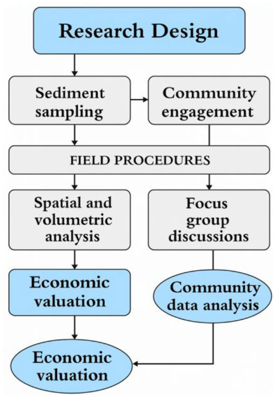
Generic protocol of the study.
3.2 Sediment sampling and field procedures
Sediment data were collected at 22 cross-sections, each comprising three lateral sampling points (left bank, thalweg, right bank), yielding 66 sampling points. The 23rd cross section had two sampling points, bringing the total number of sampling points to 68. Horizontal coordinates (X, Y) were recorded using a handheld GPS in Universal Transverse Mercator WGS84 format at approximately equidistant 0.6 km intervals. Sediment thickness (Z) in meters was measured using a manually driven GraSeD rod, specifically adapted to penetrate unconsolidated sand layers in a dry riverbed. Where basal resistance prevented full penetration, depth was measured to the confining layer (gravel or clay) using ranging poles and tapes (Groten et al., 2023). Each sediment pit was excavated to expose the full vertical profile. Fieldwork was conducted during the dry season to ensure safe access and clear visibility of bed morphology. Local field assistants were trained and engaged in supporting excavation and data handling, promoting safety and participatory research (Figure 5). Sediment depth sampling was conducted using a mixed sampling approach, that is, systematic sampling was applied in sections of the riverbed that were open and undisturbed at 0.6 km intervals, while purposive sampling was employed in bed areas where the riverbed was visibly disturbed.
Figure 5

Generic illustration of sediment depth sampling process.
3.3 Community engagement and focus group discussions
To document community experiences of fluvial sediment use, riverine change, and impact on water scarcity, three focus group discussions (FGDs) were conducted in upstream, midstream, and downstream settlements. Six gender-balanced participants were purposively selected per settlement based on local knowledge, involvement in sand abstraction, and long-term residence and exposure to water scarcity. FGDs explored topics including water sourcing, sediment-related livelihoods and sand suitability assessment, adaptation strategies, and observed geomorphic transformations. Community-derived features such as hand-dug wells, water scoop holes, and sediment mounds were documented through field sketches, photographs, and georeferenced GPS points. These observations provided additional spatial evidence of 56 community-created water points as adaptive strategies along the channel during the water-stressful period July to mid-December.
3.4 Sediment spatial and volumetric analysis
Sediment data (XYZ) were imported into ArcMap 10.4 for spatial analysis. The river channel boundary was manually digitized from Copernicus Google Earth satellite imagery and assigned a baseline zero depth. Point data were merged using the Merge tool, and a continuous sediment surface was generated using the Topo to Raster interpolation method in the 3D Analyst toolbox. This technique enabled the development of a high-resolution raster choropleth map displaying sediment thickness variations across the reach (Groten et al., 2023). Total sediment volume was computed using the Area and Volume Statistics tool. To extrapolate volumes in unsampled areas, a polynomial regression model was developed in Excel using depth–volume relationships derived from field points (Figure 6).
Figure 6

Sediment spatial and volumetric analysis framework.
3.5 Economic valuation of sediment resource
The economic value of the sediment deposit was estimated by multiplying calculated volumes by the local market price of river sand (USD/ton), obtained through interviews with regional sand suppliers. To evaluate the construction-grade suitability of the river sand sediment from the Lusitu Channel, a participatory suitability ranking was conducted using a citizen science approach. This method engaged both the researchers and a group of 18 expert participants familiar with local sediment characteristics and construction standards. Participants were asked to assess the sediment based on the following key quality indicators following the criteria by Abdias et al. (2023):
-
Fineness of the sand grains,
-
Cleanliness (i.e., the presence of silt, clay, or organic matter),
-
Particle size distribution.
Each participant independently rated the sediment's overall suitability for construction on a scale from 0 (completely unsuitable) to 1 (highly suitable). The individual ratings were then aggregated and averaged to compute a suitability coefficient. The weighting criteria was determined using the criteria in Table 1. The weighting criteria were informed by expert background of the individuals involved in the weighting process. Although the local people also had experience-based knowledge of good and bad quality sand, the technical experts were assigned a high proportion of rating equivalent to 60% while the community members involved in quarrying and selling of sand were allocated with 40% toward rating of suitability based on collective agreement by authors.
Table 1
| Group | Weighting criteria | Assigned weight |
|---|---|---|
| Experts | Professionals [engineers (2), geologists (2), material scientists (2), researchers (5)] typically have formal training and technical understanding of sand quality standards used in construction. Their input is grounded in industry criteria such as grain size distribution, fineness, and silt content. | 60% |
| Citizens | Local stakeholders (18), such as construction workers and community members, provide valuable practical knowledge based on firsthand experience. While their input may lack formal lab backing, it reflects real-world usage conditions and demand suitability. | 40% |
Weighting criteria for river sand suitability scoring.
The final suitability rating was approximated before determining whether the sediment volume is suitable for use in construction, either directly or with minimal processing (Table 2).
Table 2
| Group | Number of participants | Average rating (0–1 scale) | Weight (%) | Weighted contribution |
|---|---|---|---|---|
| Experts | 11 | 0.70 | 60 | 0.70 × 0.60 = 0.420 |
| Citizens | 18 | 0.58 | 40 | 0.58 × 0.40 = 0.232 |
| Total | 23 | – | 100 | S c = 0.652 |
Summary of suitability ratings for river sediment (Lusitu River Channel).
After determining the weighting criteria for the study context, the Equation 1 was used to determine the gross market value of Lusitu River sediment in the depositional zone.
where
GMV se d gross market value of sediment ($)
M se d load of sediment (in tons)
αse d suitability coefficient (dimensionless; range: 0 to 1)
P se d market price per ton of sediment ($/ton).
3.6 Analysis of community data
FGD transcripts were transcribed, translated, and analyzed thematically in an ethical way. Data were clustered into core themes such as water stress, sediment use practices, and informal adaptation to riverbed drying. Observed features were used to triangulate qualitative findings, ensuring alignment between lived experience and physical geomorphic evidence.
4 Results
4.1 Quantification of fluvial sediment
The study quantified sediment burden in Lusitu River based on 68 sampled points (Figure 7) along the 15 km river channel stretch from Lusitu Bridge to its confluence with the Zambezi River. The results showed spatial variation of sediment accumulation along the Lusitu riverbed. The 3D illustration is shown in Figure 8.
Figure 7

Measured and original channel bed profiles of the Lusitu River from bridge to mouth.
Figure 8

3D Illustration of the sediment depth sampling points at the mouth of Lusitu River Channel bed (image sourced from Copernicus Google, 2024).
A sediment choropleth map using 3D spatial analyst tool showed overwhelming evidence that sedimentation was a serious problem in the Lusitu River premised on the finding that almost three million cubic meters of sediment had accumulated on the bed (Figures 9A, B). This implied reduced access to water by all water-linked sectors because this enormous quantity of sediment deposit had taken up space that would have otherwise been occupied by water, thereby affecting various water-linked sectors in the catchment. The intensity of sediment accumulation was further confirmed by the observed strong positive linear relationship between sediment depth and sediment volume (r2 = 0.99, p ≤ 0.01; Figure 10). The minimum sediment depth was 0.35 m and the maximum depth was at 6.1 m, with the mean depth across the entire stretch being 3.13 m. This signifies a high magnitude rate of sedimentation, which contributed to the loss of average channel depth by about 68% (Table 3).
Figure 9

(A) Distribution of sediment pits on the Lusitu River downstream channel. (B) Choropleth map showing interpolated sediment thickness distribution, downstream of the Lusitu River.
Figure 10
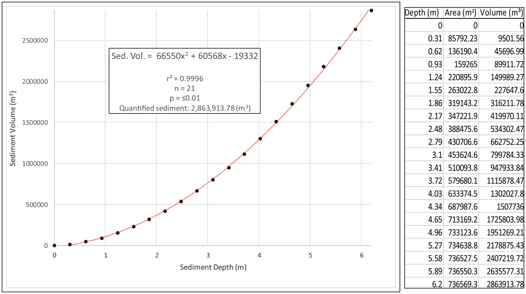
Relationship between sediment depth and sediment volume, downstream of the Lusitu River Channel.
Table 3
| Description | Mean channel depth (m) | Mean depth change (%) |
|---|---|---|
| Original mean channel depth | 4.58 | 100 |
| Mean sediment depth | 3.13 | 68.34 |
| Current average depth (original mean depth – current mean sediment depth) | 1.45 | 31.66 |
Summary statistics for Lusitu River Channel depth, October 2022.
These results imply that local people, especially the poor, would not have access to an adequate water supply. Moreover, all water-linked activities, such as gardening and livestock watering, and the generally stability of the river ecosystem would be negatively affected. There are also possibilities for off-site negative effects on the Zambezi River ecosystem because part of the sediment ends up there. With such high levels of sedimentation and loss of channel storage capacity, flash floods are a likely hazard during heavy storms, meaning that people are likely to be disturbed, relocated, and lose their farm crops (cabbage, rape, maize, bananas) that are grown near the river buffer.
The interaction of processes from the river source, transportation zone, and deposition zone or sink, as well as human activities, influenced the state of sedimentation in the Lusitu River. Based on field observations and analysis of erosion hazards maps (Lehner, 2020), spatially varied anthropogenic and physical factors propelled the erosion, transportation, and deposition of sediment in the Lusitu River (Figure 11).
Figure 11

Lusitu River basin erosion and sedimentation hazards maps.
4.2 Sources of water supply and effects of the annual drying up of the Lusitu River
The study also solicited responses from local people on their sources of water and how the drying up of the Lusitu River affected them. It was noted that the majority of the local population relied on the Lusitu River, either as their sole source of water or in combination with boreholes. A smaller portion depended exclusively on boreholes. This suggests that the Lusitu River is a central and critical water resource in the area, with limited communities having access to more secure or diversified sources like boreholes alone (Figure 12a). The most pressing issue faced by residents when the river dried up was the increased amount of time needed to fetch water, likely due to having to travel farther or waiting longer at alternative sources. Physical distance to water sources also posed a major challenge. The lack of access to clean water created hygiene issues, and some community members expressed concerns about the safety and chemical quality of the water they were forced to use. These challenges point to the vulnerability of the community when a key water source becomes unreliable (Figure 12b).
Figure 12

(a) Sources of water supply. (b) How the drying up of the Lusitu River affected local communities.
Poor hygiene practices, such as sharing wells with livestock and leaving them uncovered, increasing the risk of contamination and disease outbreaks such as diarrhea. As the dry season progresses, collapsing wells and increased water demand make water collection more time-consuming. Additionally, many residents, especially women and children, travel long distances to the river, preferring the taste of river sand water over nearby saline borehole water. Although the residents preferred interstitial water in the river sand, uncertainties about its chemical and biological quality were raised showing the need for improved water safety measures (Table 4).
Table 4
| Themes | Description |
|---|---|
| Lack of hygiene | •Sharing water wells with livestock •Wells not covered properly •Water being linked to outbreaks of diarrhea in Lusitu |
| Increased time for drawing water | •Collapsing of unreinforced water wells due to unstable sediment •Dependency on water wells increased with the progression of the dry season |
| Long distance to the river | •Boreholes nearby are saline •Water in the sand tastes better than boreholes |
| Uncertainty about chemical and biological quality | •Not certain of the biological and chemical composition of the water •There could be some chemicals and small living things in water |
Effects of the fluvial sedimentation of Lusitu River on domestic water supply.
4.3 Coping strategies to sedimentation-driven water scarcity
The sedimentation of the Lusitu River led to its loss of perenniality and, over the years, local people have developed localized coping mechanisms to water stresses which span 8 months from May to December, accounting for 67% of the year. During this stressful water period, during which water is locked in sediment, local communities dug shallow wells on the riverbed, which were 47 in number compared to six sand reservoirs constructed by Chirundu Town Council and three natural pools (Figure 13). Although the river was indeed silent due to zero flows during two-thirds of the years, the study established that there is plenty of interstitial water trapped in sediment that meets all water demands for crop irrigation, livestock watering, and household use throughout the year. The study also found that families and individuals who were well off reinforced the sand well walls with PVC drums or concrete rings and inserted water pumps for very efficient water supply. Only the poor were at a disadvantage because they could not afford pumps, and hence had to travel daily to fetch water from the shallow wells.
Figure 13

Community resilience strategies to water scarcity in the Lusitu Basin: (a) distribution of water access points during water-stressful period; (b) women and children fetching water from shallow well; (c) sand reservoirs.
4.4 Estimation of gross market value of sediment on the Lusitu Channel bed
The study found that sediment deposited in the 15 km downstream section of the Lusitu River Channel had a gross market value estimated at about 11 million USD (Table 5).
Table 5
| Variable | Quantitative description |
|---|---|
| Weight of 1 m3 of sand (tons) | 1.62 |
| Volumetric quantity of sediment (m3) | 2,863,913.78 |
| Weight of measured sediment (tons) | 4,639,540.32 |
| (based on) participatory suitability rating (Sc) | 0.652 |
| Adjusted weight of sediment (in tons) | 3,024,980.29 |
| Local market value of a ton of sand river (US$) | 3.7 |
| Gross market value of sediment (US$) | 11,192,427 |
Summary of gross market value of sediment downstream of the Lusitu River Channel (measurement of sediment took place in October 2022).
5 Discussion
The Lusitu River, in its mature stage, exhibits classic low-energy fluvial behavior, characterized by significantly reduced stream power and a gentle gradient that fosters in-channel sediment accumulation. With an elevation drop of just 29 m over a 15 km stretch from Lusitu Bridge (405 m) to the river mouth (376 m), the resulting gradient of approximately 1.9 m/km encourages sediment retention within the channel (Singubi et al., 2023). Our study estimates that nearly 2.9 million cubic meters (approximately 4.6 million tons) of sediment have accumulated in this lower reach, a scale comparable to the cumulative siltation of 35 small dams in the Magoye Basin in southern Zambia (Simweene and Muchanga, 2021; Muchanga and Sichingabula, 2021; Ministry of Water Development and Sanitation, 2022; Singubi et al., 2023). This magnitude mirrors findings in other sediment-prone systems globally, such as the Amazon River Basin, where Ferreira et al. (2013) highlighted anthropogenically driven sedimentation, and the Mazowe Catchment in Zimbabwe, where Tundu et al. (2018) observed severe reservoir lifespan reduction due to sediment overload. Unlike suspended sediment-focused studies such as those by Qin et al. (2011) and Walling and Fang (2003), our investigation emphasizes bedload sediment accumulation, providing a more direct link to riverbed morphology change and water stress, a gap previously identified in both African and global literature. While Tipper et al. (2025) and Muchanga and Mafwabo (2025) contributed valuable insights on sediment characteristics and provenance, their studies lacked explicit integration with water scarcity frameworks, a critical omission in regions where communities rely heavily on river systems for multiple uses.
The Lusitu case illustrates a dual water scarcity regime created by sedimentation. In the wet season, excessive turbidity renders the water unfit for human consumption, though still usable for livestock. In the dry season, surface flows vanish, but the accumulated sediment acts as a sponge, retaining interstitial water accessible through shallow wells, contrary to the earlier understanding that the Lusitu River dries up completely each year (Henegan, 2023). This aligns with hydrological findings from semi-arid river systems in Kenya, where sand dams maintain subsurface water flows for prolonged periods (Ritchie et al., 2021; Gur and Spluhler, 2023), and resonates with evidence from sandy rivers in the Barotse Floodplain (Zimba et al., 2018) and the Luangwa Basin (WWF, 2018). The persistence of subsurface flows even in peak dry months (for example, October), when water is available at a depth as shallow as 20 cm below the surface, reflects a dynamic surface–subsurface hydrological exchange. This mechanism, driven by the high porosity and capillarity of sandy sediments (Mafwabo et al., 2023) illustrates hydrological resilience uncommon in clay-rich systems, which typically lack infiltration capacity and are prone to complete desiccation (Lehner, 2020). Therefore, the Lusitu presents a unique hydrologic archetype within the Zambezi Basin, deserving tailored management strategies distinct from those suited to clay-dominated catchments.
Moreover, the socioeconomic dimensions of sediment-induced intermittency reveal pronounced inequalities. Households with access to financial resources install submersible pumps and reinforce well structures using concrete or plastic drums, ensuring year-round water supply for livestock and domestic use. In contrast, poorer households resort to manual abstraction methods, often walking long distances, a trend similarly reported by Mulatu et al. (2024) in the Upper Blue Nile Basin, where socioeconomic disparities dictated adaptation capacity. The burden on women and children further amplifies existing gender- and age-related vulnerabilities in water access, as previously observed in other sediment-affected basins (Muchanga and Mafwabo, 2025; Chisola and Kuraz, 2016; Zhide and Yuling, 2023). The shared use of shallow wells by livestock and humans, especially in the absence of proper well linings, raises public health concerns related to pathogen transmission and chemical contamination, echoing issues noted by Muchanga and Sichingabula (2021) and suggested by Tipper et al. (2025) in sediment-impacted ecological systems. These risks remain largely unquantified, highlighting a critical need for water quality monitoring and management in informal, sediment-based water abstraction practices. A study by Schessl (2018) in the Eyasi Basin in Tanzania shows that indigenous people's adaptation to water scarcity in this basin is similar to that found in the Lusitu Basin. Hence, fluvial sedimentation is not merely a burden, it offers opportunity for trapping of water for use when surface flows cease and also offers latent economic value, though this must be pursued cautiously for ecological reasons. The continental fluvial sediment stock in the Lusitu River has an estimated market value of USD 11 million, suggesting a transformative opportunity if managed sustainably and with caution. Sediment extraction has been proven viable in the Chipapa Dam case (Mwiinde, 2017) and the Great Lakes region (Great Lakes Commission, 2013), where profits were potentially significant, although with minimal environmental safeguards. Our study proposes a participatory suitability rating (PSR) valuation framework, which could be replicated across sandy alluvial systems in Zambia and beyond to optimize ecosystem service utilization. Yet, as Walling and Fang (2003) and Mwiinde (2017) note, sediment management policies have focused disproportionately on suspended loads and reservoir siltation, often ignoring in-channel bedload deposits.
This research bridges a crucial knowledge gap by quantifying bedload sediment and contextualizing it within both hydrological and socioeconomic frameworks, reinforcing calls by Woo et al. (2023) and Tikuye et al. (2023) for integrated sediment governance that spans catchment to community scales. It also aligns with the global shift toward interdisciplinary river basin management, as advocated in recent reviews (Garvey and Whiles, 2023; Hasan et al., 2024) calling for sediment studies to be socially and ecologically grounded, rather than narrowly geophysical. Last, we recommend that legal frameworks and policy instruments recognize and regulate community-led adaptation practices, such as informal well construction and sediment repurposing. This would not only legitimize essential survival strategies, but also reduce friction between regulatory authorities and communities, echoing recommendations from earlier water governance analyses in sediment-prone catchments (Muchanga and Mafwabo, 2025; Woo et al., 2023). As Zambia's fluvial systems face intensifying anthropogenic and climatic pressures, studies like this can inform evidence-based, locally tailored, and inclusive river basin management strategies, ensuring water security, ecological integrity, and economic opportunity in an integrated way.
While this study may have some limitations on account of focusing only on the downstream side of the river system and possibly for not having been able to sample sediment depth up to the very original river bed, as well as potential weaknesses in our invented sediment valuation, it offers novel insights with broad international applicability, especially for semi-arid and arid regions where sandy-bedded rivers are prevalent. First, it challenges dominant hydrological paradigms by revealing that rivers previously classified as “seasonally dry” may in fact retain significant subsurface flow year round due to sediment porosity, an overlooked mechanism in conventional river classification schemes. This reconceptualization has global relevance, particularly for water-scarce regions where sandy ephemeral rivers with good surface flow–baseflow interaction are common but poorly understood. Second, the integration of a PSR model to quantify the market value of riverbed sediment represents a methodological innovation. Unlike prior studies that focused primarily on suspended sediment in reservoirs, this work pioneers a practical approach to evaluating bedload sediment as an economic resource within active river channels. The method is adaptable and scalable to other fluvial systems with similar geomorphic characteristics, offering a replicable framework for sustainable sediment management in river systems. Last, by documenting community-led adaptations to sediment-induced water scarcity, the study adds to the growing field of socio-hydrology, illuminating how informal, often gendered, water access practices evolve under environmental stress. These findings are not only relevant for Zambia, but also resonate with international discourses on climate adaptation, hydrological resilience, and equitable resource governance. Specifically, the study argues that although the Lusitu River may appear dry on the surface, the flows continue in the subsurface supplying all the minimum water resources needs for the rural poor especially during the water-stressful period (July to early December). This could potentially be the case for other rivers within the tropics and therefore it is not a correct idea to perceive rivers with sandy beds as completely dry merely because the bed surface is dry, Lusitu River is such a practical example.
6 Conclusion and recommendations
This study addresses a critical but often overlooked research gap in fluvial geomorphology and water resource management: the role of fluvial sedimentation in driving water scarcity in semi-arid river systems. Focusing on the lower Lusitu River in southern Zambia, we pursued the objective of quantifying sediment volume, assessing its socioeconomic implications, and exploring community adaptation strategies in response to sediment-induced hydrological changes. Using a concurrent embedded mixed-methods design including geomorphological sampling, spatial interpolation, economic valuation via PSR, and thematic analysis of community perspectives, we provide empirical evidence of how sediment dynamics reshape river functionality. Our findings reveal that sedimentation has dramatically altered the Lusitu River channel, with approximately 2.86 million m3 (4.64 million tons) of sand occupying 68.34% of its original depth. This accumulation severely restricts surface water flow, contributing to prolonged dry periods from July to December. However, contrary to perceptions of a seasonally inactive river, we document persistent subsurface (interstitial) hydrological activity that supports 56 informal community-built water points. These adaptations, though essential for household and agricultural survival, expose deep inequalities, with water access shaped by socioeconomic status and infrastructure availability. The poorer majority rely on labor-intensive hand-dug wells, while wealthier households benefit from reinforced wells and pumps. Beyond the hydrological and social dimensions, our study demonstrates that the sediment has substantial untapped economic value, estimated at USD 11.2 million, based on a PSR of 0.652. This positions sediment not only as a barrier but also as a latent asset, offering an opportunity to integrate sediment management into broader resilience and livelihood strategies.
In conclusion, this study challenges prevailing assumptions about the Lusitu River and others sharing similar hydro-geomorphological characteristics, revealing it not as a dry or defunct channel, but as a dynamic dual hydrological system where perennial water availability is sustained through interstitial flows within a heavily sedimented riverbed. This transformation redefines the river's role as a vital, though often hidden, water source shaped by sediment accumulation especially during extended dry seasons. While sedimentation poses socioeconomic and health challenges, particularly for vulnerable rural populations, it also presents untapped opportunities. By bridging geomorphological analysis with socioeconomic and community-led insights, the study presents a user-friendly framework for valuating sediment on riverbeds. These include formal recognition of community-built sand wells, environmentally sensitive sediment extraction guidelines, and incorporation of subsurface hydrology into basin-wide water planning. Such reforms not only legitimize community-based infrastructure, but also promote equitable resource use. With informed governance and active community participation, the Lusitu River holds transformative potential for community-based water security and sustainable development, serving as a model of sediment-based resilience for other semi-arid, sediment-affected river systems globally. We strongly recommend modern technology interventions that can help enhance the quality of water that people extract from the subsurface of the riverbed.
Statements
Data availability statement
The original contributions presented in the study are included in the article/Supplementary material, further inquiries can be directed to the corresponding author.
Author contributions
MM: Conceptualization, Data curation, Investigation, Methodology, Supervision, Visualization, Writing – original draft, Writing – review & editing. NS: Data curation, Investigation, Resources, Validation, Writing – original draft, Writing – review & editing. HS: Validation, Writing – review & editing. RW: Methodology, Validation, Writing – review & editing. IZ: Software, Visualization, Writing – review & editing.
Funding
The author(s) declare that no financial support was received for the research and/or publication of this article.
Acknowledgments
We acknowledge all research assistants who endured intense heat in the semi-arid Lusitu River Catchment during digging of sediment pits without whom the tedious work would have been more challenging.
Conflict of interest
The authors declare that the research was conducted in the absence of any commercial or financial relationships that could be construed as a potential conflict of interest.
Generative AI statement
The author(s) declare that Gen AI was used in the creation of this manuscript. Chatgpt was used to reduce the length of the Abstract from 404 to about 300 but without addition of any new words. The rest remains our original work
Any alternative text (alt text) provided alongside figures in this article has been generated by Frontiers with the support of artificial intelligence and reasonable efforts have been made to ensure accuracy, including review by the authors wherever possible. If you identify any issues, please contact us.
Publisher’s note
All claims expressed in this article are solely those of the authors and do not necessarily represent those of their affiliated organizations, or those of the publisher, the editors and the reviewers. Any product that may be evaluated in this article, or claim that may be made by its manufacturer, is not guaranteed or endorsed by the publisher.
Supplementary material
The Supplementary Material for this article can be found online at: https://www.frontiersin.org/articles/10.3389/ffwsc.2025.1587668/full#supplementary-material
References
1
Abdias M. Blanche M. Nana U. Abanda H. François N. Chrispin P. (2023). River sand characterization for its use in concrete: A revue. Open J. Civ. Eng.13, 353–366. 10.4236/ojce.2023.132027
2
Baumle R. Neukum C. Nkhoma J. Silembo O. (2007). The Groundwater Resources of Southern Province, Zambia (Phase 1), 1-Technical Report, Lusaka.
3
Chisola N. M. Kuraz M. (2016). Patterns and implications of hydrologic regime change in Chongwe River, Zambia. J. Geogr. Geol.8:1. 10.5539/jgg.v8n3p1
4
Engdaw F. Kifle D. Fetahi T. (2025). Water quality parameters influence temporal dynamics of zooplankton community structure in a tropical highland lake, Lake Tana, Ethiopia. Mar. Pollut. Bull.218:118239. 10.1016/j.marpolbul.2025.118239
5
Ferreira A. L. P. Neves A. P. Figueira C. L. R. (2013). Evaluation of Recent sedimentation rated in Guajara Bay (Brazilian Coast) with Cesium and Lead.São Paulo, SP: Institute of Oceanography at the University of São Paulo.
6
Garvey J. E. Whiles M. R. (2023). Incorporating the riverscape into models of river–floodplain function. Front. Freshw. Sci.1:1265423. 10.3389/ffwsc.2023.1265423
7
Geological Department of Zambia (GDZ) (2013). Geological Maps of Zambia. Lusaka: GDZ.
8
Gómez B. Jones J. P. III (Eds.). (2010). Research methods in geography: A critical introduction. Wiley, Blackwell.
9
Google . (2024). Google Earth Pro (Version 7.3.6.9796). Google LLC. Available online at: https://www.google.com/earth/versions/#earth-pro
10
Great Lakes Commission (2013). Beneficial Use of Dredged Material in the Great Lakes. Ann Arbor, MI: State of Michigan, United States of America.
11
Groten J. T. Levin S. B. Coenen E. N. Lund J. W. Johnson G. D. (2023). A Novel Suspended-Sediment Sampling Method: Depth-Integrated Grab (DIG). Appl. Sci.13:7844. 10.3390/app13137844
12
Gur E. Spluhler D. S. (2023). Sand dams and subsurface dams. Available online at: https://sswm.info/sswm-solutions-bop-markets/improving-water-and-sanitation-services-provided-public-institutions-0/sand-dams-and-subsurface-dams (Accessed July 24, 2023).
13
Hamatuli M. Muchanga M. (2021). Social perspectives on effects of buffer zone anthropogenic activities on mashili reservoir of Shibuyunji District, Central Province, Zambia. Eur. J. Environ. Earth Sci.2, 43–48. 10.20431/2349-0381.0811013
14
Hasan I. Dey J. Rahman Munna M. M. Preya A. Nisanur T. B. Memy M. J. et al . (2024). Morphological changes of river bank erosion and channel shifting assessment on Arial Khan River of Bangladesh using Landsat satellite time series images. Prog. Disaster Sci.24:100381. 10.1016/j.pdisas.2024.100381
15
Henegan C. (2023). When the river runs dry in Lusitu, Zambia. Commons. NIES 24–29. https://pulitzercenter.org/sites/default/files/inline-images/January_The-Commons_ISSUU_1-18-23-FINAL.pdf (Accessed July 30, 2025).
16
Lehner B. (2020). WRPA-Zambia GIS database. Technical Documentation Version 1.0. Lusaka: WWF.
17
Mafwabo D. Muchanga M. Wankie R. Singubi N. Zulu I. (2023). Anthropogenic geomorphology of the Magoye riverine landscape, Zambia. Asian J. Geogr. Res.6, 1–16. 10.9734/AJGR/2023/v6i4199
18
Ministry of Water Development and Sanitation (2022). Magoye River Catchment Restoration Plan. Lusaka: MWDS.
19
Muchanga M. Mafwabo D. (2025). Granulometric characterisation and distribution of contemporary fluvial sediment in the Magoye River sink, Southern Zambia. Eur. J. Appl. Sci.13, 97–110. 10.14738/aivp.1303.18737
20
Muchanga M. Sichingabula H. M. (2021). Spatial and seasonal dynamics of total suspended sediment, total dissolved solids and turbidity of a lacustrine reservoir in the Magoye Catchment, Southern Zambia. Eur. J. Environ. Earth Sci.2, 43–48. 10.24018/ejgeo.2021.2.6.227
21
Mulatu C. A. Yemer G. G. Abebe W. B. Amsalu Y. (2024). Long-term effects of Abay River flow regulation at Lake Tana on the geomorphic and ecological responses of the downstream river channels, Upper Blue Nile basin, Ethiopia. Heliyon10:e40223. 10.1016/j.heliyon.2024.e40223
22
Mwiinde D. (2017). Cost Benefit Analysis of Sediment and Sedimentation in Selected Small Dams in Lusaka and Southern Provinces, Zambia. Lusaka: University of Zambia.
23
Qin Y. Zhang X. Wang F. Yan H. Han H. (2011). Scour and silting evolution and its influencing factors in Inner Mongolia Reach of the Yellow River. J. Geogr. Sci.21, 1037–1046. 10.1007/s11442-011-0898-6
24
Ritchie H. Eisma J. A. Parker A. (2021). Sand dams as a potential solution to rural water security in drylands: existing research and future opportunities. Front. Water3:651954. 10.3389/frwa.2021.651954
25
Schessl A. K. G. (2018). The Hadzabe and climate change. Retrieved from https://www.aksik.org/index.php/node/3595 (Retrieved September 4, 2025).
26
Sharma A. Castro-Bolinaga C. Nelson N. Mittelstet A. (2025). Simulating fluvial sediment pulses using remote sensing and machine learning: development of a modeling framework applicable to data rich and scarce regions. Int. J. Sediment Res.40, 523–536. 10.1016/j.ijsrc.2025.02.002
27
Sichingabula H. M. Chisola M. Muchanga M. Chomba I. Sikazwe H. Chinonge M. et al . (2022). Kaleya river catchment regional estimation of reservoir capacities using solar and GIS approaches. J. Natl. Appl. Sci.6, 1–13. 10.53974/unza.jonas.6.1.391
28
Simweene S. Muchanga M. (2021). Socio-hydrological learning for integrated siltation control and water resources management in a small reservoir of Southern Zambia. Am. J. Hum. Soc. Sci.29, 24–32.
29
Singubi N. Muchanga M. Wankie R. Zulu I. (2023). Citizens science perspectives on drivers of sedimentation in the Lusitu River Catchment in Chirundu District, Zambia. J. Geogr. Environ. Earth Sci. Int.27, 30–44. 10.9734/jgeesi/2023/v27i7694
30
Tikuye B. G. Gill L. Rusnak M. Manjunatha B. R. (2023). Modelling the impacts of changing land use and climate on sediment and nutrient retention in Lake Tana Basin, Upper Blue Nile River Basin, Ethiopia. Ecol. Model.482:110383. 10.1016/j.ecolmodel.2023.110383
31
Tipper E. T. Bouchez J. Lipp A. Lupker M. (2025). “The geochemistry of fluvial sediments from large rivers: old problems and new developments,” in Treatise on Geochemistry, eds. A. Anbar and D. Weis, 3rd Edn. (Amsterdam: Elsevier), 315–351.
32
Tundu C. Tumbare M. J. Onema J. M. K. (2018). Sedimentation and its impacts/effects on river system and reservoir water quality. Proc. Int. Assoc. Hydrol. Sci.377, 57–66. 10.5194/piahs-377-57-2018
33
Walling D. E. Fang D. (2003). Recent trends in the suspended sediment loads of the world's rivers. Glob. Planet. Change39, 111–126. 10.1016/S0921-8181(03)00020-1
34
Woo H. Julien P. Y. Yoon B. Choi S.-U. (2023). Sedimentation issues of the four major rivers restoration project in South Korea. J. Hydro Environ. Res.50, 57–61. 10.1016/j.jher.2023.08.001
35
WWF (2018). Integrated flow assessment for the Luangwa River. Phase 1: Basin configuration of EFlows. Zambia: WWF.
36
Xu J. (2002). River sedimentation and channel adjustment of the lower Yellow River as influenced by low discharges and seasonal channel dry-ups. Geomorphology43, 151–164. 10.1016/S0169-555X(01)00131-3
37
Zaw N. W. Intralawan A. (2014). Assessments of Land Use/Land Cover Change and Soil Erosion: A Case Study of Kalaw Chaung Sub-watershed of Inle Lake, Myanmar. Bangkok: International Society of Environmental and Rural Development.
38
Zhide Z. Yuling T. (2023). Sediment in rivers: origin and challenges. The International Research and Training Center on Erosion and Sedimentation. Available online at: https://sswm.info/node/4092 (Accessed July 19, 2023).
39
Zimba H. Kawawa B. Chabala A. Phiri W. Selsam P. Meinhardt M. et al . (2018). Assessment of trends in inundation extent in the Barotse Floodplain, upper Zambezi River Basin: a remote sensing-based approach. J. Hydrol. Region. Stud.15, 149–170. 10.1016/j.ejrh.2018.01.002
Summary
Keywords
fluvial sedimentation, Lusitu River, water scarcity, subsurface flow, sediment valuation, semi-arid rivers
Citation
Muchanga M, Singubi N, Sichingabula HM, Wankie R and Zulu I (2025) The nature and implications of water scarcity caused by fluvial sedimentation in the Lower Lusitu River Channel, southern Zambia. Front. Freshw. Sci. 3:1587668. doi: 10.3389/ffwsc.2025.1587668
Received
04 March 2025
Accepted
10 September 2025
Published
08 October 2025
Volume
3 - 2025
Edited by
James E. Garvey, Southern Illinois University Carbondale, United States
Reviewed by
Mebrahtom Kebedew, Florida Gulf Coast University, United States
Constantin Nistor, Universitatea Hyperion din Bucureşti, Romania
Updates
Copyright
© 2025 Muchanga, Singubi, Sichingabula, Wankie and Zulu.
This is an open-access article distributed under the terms of the Creative Commons Attribution License (CC BY). The use, distribution or reproduction in other forums is permitted, provided the original author(s) and the copyright owner(s) are credited and that the original publication in this journal is cited, in accordance with accepted academic practice. No use, distribution or reproduction is permitted which does not comply with these terms.
*Correspondence: Manoah Muchanga mmuchanga@unza.zm
†ORCID: Manoah Muchanga orcid.org/0000-0002-1156-4245
Disclaimer
All claims expressed in this article are solely those of the authors and do not necessarily represent those of their affiliated organizations, or those of the publisher, the editors and the reviewers. Any product that may be evaluated in this article or claim that may be made by its manufacturer is not guaranteed or endorsed by the publisher.