 Yicheng Xu1*‡
 Hannah Sirianni2‡
 Eric Wade1,3‡
 Fushcia-Ann Hoover4‡
 Anuradha Mukherji2‡
 Siddharth Narayan1,4†‡
- 1Department of Coastal Studies, East Carolina University, Greenville, NC, United States
- 2Department of Earth, Environment, and Planning, East Carolina University, Greenville, NC, United States
- 3Department of Marine, Earth, and Atmospheric Sciences, North Carolina State University, Raleigh, NC, United States
- 4Department of Earth, Environmental and Geographical Sciences, University of North Carolina Charlotte, Charlotte, NC, United States
High-tide flooding (HTF) is an increasingly frequent and disruptive phenomenon in coastal regions worldwide, driven by rising local sea levels. Despite recent attention to the drivers of this emerging flood hazard, the scope and extent of socio-economic impacts of HTF impacts are not well understood. This study presents a global systematic review of studies that quantitatively assess the socio-economic impacts of HTF. A total of 993 peer-reviewed English-language studies published between 1985 and October 2024 were identified through Scopus and Google Scholar. Of these, 194 focus on HTF events, of which 26% address socio-economic impacts. The review shows that the vast majority of HTF impact studies, 72%, are focused on U.S. geographies with Indonesia having the second largest number of HTF impact studies (20%). In the United States, socioeconomic impacts from HTF events have been assessed in 24 cities across the Atlantic, Gulf and Pacific coasts with Norfolk, VA and Miami, FL on the Atlantic having the most number of assessments. HTF impacts affect multiple socio-economic sectors, including public infrastructure, private sectors, and environmental health. However, even among studies in the same sector, the use of different baselines, scales, and HTF event threshold definitions makes it difficult to compare HTF impacts across locations. From these findings our review identifies four points for further research on the socio-economic impacts of HTF to improve collective understanding of these emerging coastal risks.
1 Introduction
Coastal areas offer numerous benefits to people, industry, and the economy, and are home to more than 600 million people worldwide (Macmanus et al., 2021). However, these regions face increasing threats from climate change, particularly sea-level rise (SLR) (Cazenave and Cozannet, 2014). Globally, nearly 900 million people live within the Low-Elevation Coastal Zone, defined by the 10 meter elevation contour, and are exposed to coastal flood risks (Reimann et al., 2023). Research shows that coastal population and urbanization are expected to grow significantly throughout the 21st century, particularly in the Low-Elevation Coastal Zone (Reimann et al., 2023). The largest increases are projected in Asia, especially in China, India, Bangladesh, Indonesia, and Viet Nam, and in parts of Africa such as Egypt and sub-Saharan regions of West and East Africa (Neumann et al., 2015).
In addition to rapid growth along coastal zones, high-tide flooding (HTF), i.e., intermittent flooding of low-lying coastal areas due to higher-than-expected tide-induced water levels, is an emerging coastal hazard (Moftakhari et al., 2018). Also known as “sunny-day flooding” or “nuisance flooding,” HTF is a complex phenomenon driven by global SLR and local conditions like wind patterns (Thelen et al., 2024), land subsidence (Fiaschi and Wdowinski, 2020), or channel dredging (Li et al., 2021). As local sea levels continue to rise, HTF events are projected to become more frequent and severe across global coastal regions (Hague et al., 2023), and are already being studied worldwide, including the United States (U.S.) (Sweet et al., 2018; Thompson et al., 2021), Australia (Hague et al., 2022), Indonesia (Marfai et al., 2008), and China (Li et al., 2023).
As SLR is one of the main drivers of HTF events, research on the impacts of HTF is often linked with assessments of the effects of future SLR. These studies evaluate future HTF impacts based on SLR scenarios, estimating increased flood frequency, expanded inundation extents, and rising economic losses (Hsiao et al., 2024), risks to archaeological sites (Elliott and Williams, 2021), isolation due to roadway flooding (Jasour et al., 2022), and inundation risks to seaports (Allen et al., 2021). However, studies focused on future SLR impacts do not capture the scope or severity of HTF challenges already affecting coastal communities.
Studies that examine present-day coastal flooding often consider HTF, or more generally tides, as a component of broader compound flooding or extreme sea level (ESL) events, i.e., flooding from multiple sources, making it difficult to isolate the specific role and impact of HTF events. For example, compound flood modeling frameworks often simulate interactions between tides, storm surge, river discharge, and waves, where tidal elevations are one of several overlapping flood drivers (Bennett et al., 2023; Nederhoff et al., 2024). Furthermore, models combine tide and surge events, rather than isolating their individual contributions to tidal flooding, which risks overlooking the impacts of recurring HTF (Wong et al., 2022). This blending of flood sources, combined with the lack of studies specifically addressing HTF events, complicates efforts to assess specific, present-day impacts of HTF on coastal communities.
The challenge of assessing HTF impacts is further complicated by the localized nature of topography, sea level variability, built environment, and social vulnerability, which makes geographic context and spatial scale critical for accurate impact assessment. Unlike storm surge assessments that often apply broad increments, such as 1 to 2 meters of increase in water levels (Peter Sheng et al., 2022), HTF thresholds are typically much smaller and more sensitive to local conditions. In the U.S., the National Oceanic and Atmospheric Administration (NOAA) proposed a national HTF threshold, which is typically set at around 0.5 to 0.6 meters above the local Mean Higher High Water (MHHW) line (Sweet et al., 2018). This means that even small variations in elevation or sea level can significantly affect which areas experience flooding (Li et al., 2021). Even within the same city, neighborhood-level differences in built environment and social vulnerability to flooding from HTF can lead to drastically different impacts (Bukvic et al., 2021), highlighting the importance of understanding local variations for effective flood risk management (De Moel et al., 2015).
Managing the risks posed by HTF requires a nuanced understanding of how these events impact society across multiple sectors. HTF events pose persistent risks to daily functioning in tidally influenced communities, where flooding can occur without storms, particularly in tidally influenced human populations and economic activities (Spanger-Siegfried et al., 2017; Spanger-Siegfried et al., 2014). Unlike storm-induced flood events that are often associated with catastrophic damages requiring extensive recovery efforts, flood insurance payouts, and long recovery times (Schneider et al., 2019; Galloway, 2008), a single HTF event typically results in minor damage that often falls below the lowest deductible rate of 1,000 USD in Special Flood Hazard Areas (SFHAs) under the National Flood Insurance Program (NFIP) in the U.S. (Dombrowski et al., 2020). Yet, as these events become more frequent, their cumulative impacts, such as transportation route disruptions (Jacobs et al., 2018), stormwater systems issues (Habel et al., 2020), challenges for vulnerable populations such as seniors (Mueller et al., 2024), impacts on local businesses (Hino et al., 2019), and increased public health concerns around water contamination (Macías-Tapia et al., 2021), can rival the long-term costs of more severe disasters (Moftakhari et al., 2017; Paulik et al., 2021).
The unique nature of HTF events and their ongoing impacts on coastal communities, combined with a poor understanding of nature and magnitude of socio-economic impacts, and their geographic distribution and scale make it challenging for flood risk managers to assess and plan for HTF events. This includes developing robust cost–benefit analyses, which are essential for designing and implementing effective mitigation strategies (Mechler et al., 2014). While a growing number of studies have examined the impact of HTF in specific locations or sectors, no global synthesis has systematically assessed its socio-economic dimensions across geographic regions and impact sectors.
To address this gap, we conducted the first global systematic review of socio-economic impacts of HTF, guided by the following questions: (1) How are HTF impacts understood in relation to SLR and other types of coastal flooding?, (2) Where are HTF-related socio-economic impacts being observed or modeled?, and (3) What is the type and extent of these impacts? To answer these questions, we examined the evolution of current scientific understanding of HTF events as a unique driver of coastal flood risks, described the geographic distribution and scales of the observed and modelled impacts of HTF events across the world, and quantified the relative extent of different socio-economic impacts due to HTF events.
2 Method
2.1 Selecting studies focused on HTF
This systematic literature review followed the PRISMA (Preferred Reporting Items for Systematic Reviews and Meta-Analyses) guidelines for systematic reviews (Page et al., 2021). A structured selection process was followed to identify and select articles that aligned with the study’s objectives (Figure 1). Study selection was conducted in duplicate, with the lead author and one co-author independently screening titles, abstracts, and full texts. Discrepancies were discussed and resolved by consensus. Data extraction was conducted by the lead author and reviewed by co-authors to ensure accuracy.
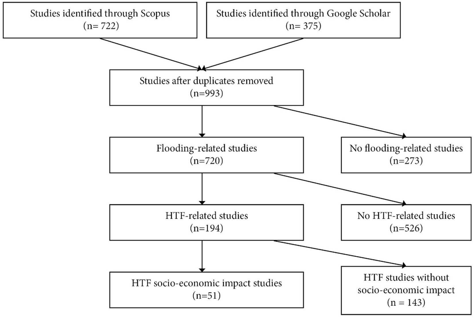
Figure 1. Flowchart of the study selection process following PRISMA guidelines. After removing duplicates, 993 studies were reviewed, 720 focused on flooding, 194 focused on HTF, and 51 addressed the socio-economic impacts of HTF.
The first step in the review process involved selecting studies focused on HTF events. HTF is often referred to by a variety of terms in the literature, including “high tide flooding” (Fant et al., 2021), “king tide flooding” (Hunter, 2020), “spring tide flooding” (Macías-Tapia et al., 2021), “sunny-day flooding” (Mueller et al., 2024), “sea level rise induced flooding” (Habel et al., 2020), “nuisance flooding” (Moftakhari et al., 2018), and “chronic flooding” (Ghanbari et al., 2020). These keywords were used to identify HTF-related studies.
A literature search was conducted using the Scopus database, which supports Boolean operators. The OR operator was applied to capture documents containing any of the listed keywords. To be included, studies had to be English-language, peer-reviewed journal articles (excluding dissertations, theses, conference abstracts, technical government reports, and book chapters) published between 1985 and 2024, with 1985 chosen as the starting point because it is the earliest study that appeared after search.
The following search string was applied in Scopus on October 24, 2024: “High tide flooding” OR “Nuisance flooding” OR “King tide flooding” OR “Spring tide flooding” OR “Sea level rise induced flooding” OR “Sunny day flooding” OR “Chronic flooding” AND PUBYEAR > 1984 AND PUBYEAR < 2025 AND (LIMIT-TO (DOCTYPE, “ar”)) AND (LIMIT-TO (LANGUAGE, “English”)).
To ensure no relevant studies were missed, the same keywords were also searched in Google Scholar as a supplementary source. Studies from the first ten pages of Google Scholar search results were reviewed. In total, the search identified 1,097 peer-reviewed journal articles: 722 from Scopus and 375 from Google Scholar. Among these, 104 were duplicates.
Studies were further excluded from all identified non-duplicates (n = 933) if they did not meet the definition of flooding as the temporary wetting of dry areas (Flick et al., 2012). First, titles and abstracts were manually reviewed and categorized based on whether the study focused on flooding or non-flooding, using this definition of “flooding.” This review identified a total of 720 studies focused on flooding, and 273 non-flooding related studies.
The abstracts and full texts of all flooding related studies were then screened to identify the main type of flooding explored, and each study was classified into one of eight different flooding categories (Table 1). Studies were classified as HTF if they focused on low-intensity, recurrent coastal flooding primarily driven by tides, with or without other contributing factors such as rising sea levels, land subsidence, or local wind and atmospheric conditions. To ensure conceptual consistency, studies involving extreme compound flooding, storm surges, tropical cyclones, or heavy rainfall were not considered HTF-related unless tide was explicitly identified as a distinct flooding mechanism and its specific impacts were reported in the abstract or main text. This review identified a total of 194 studies that specifically addressed present-day HTF, while 526 focused on the other seven flooding categories. All HTF-related studies were further sub-categorized based on the specific manner in which they treated HTF events, i.e., studies that focused only on past and present HTF, studies that included future SLR, studies that reported the contribution of different compound flooding factors including HTF, and studies that reported multiple types of flooding, including HTF.
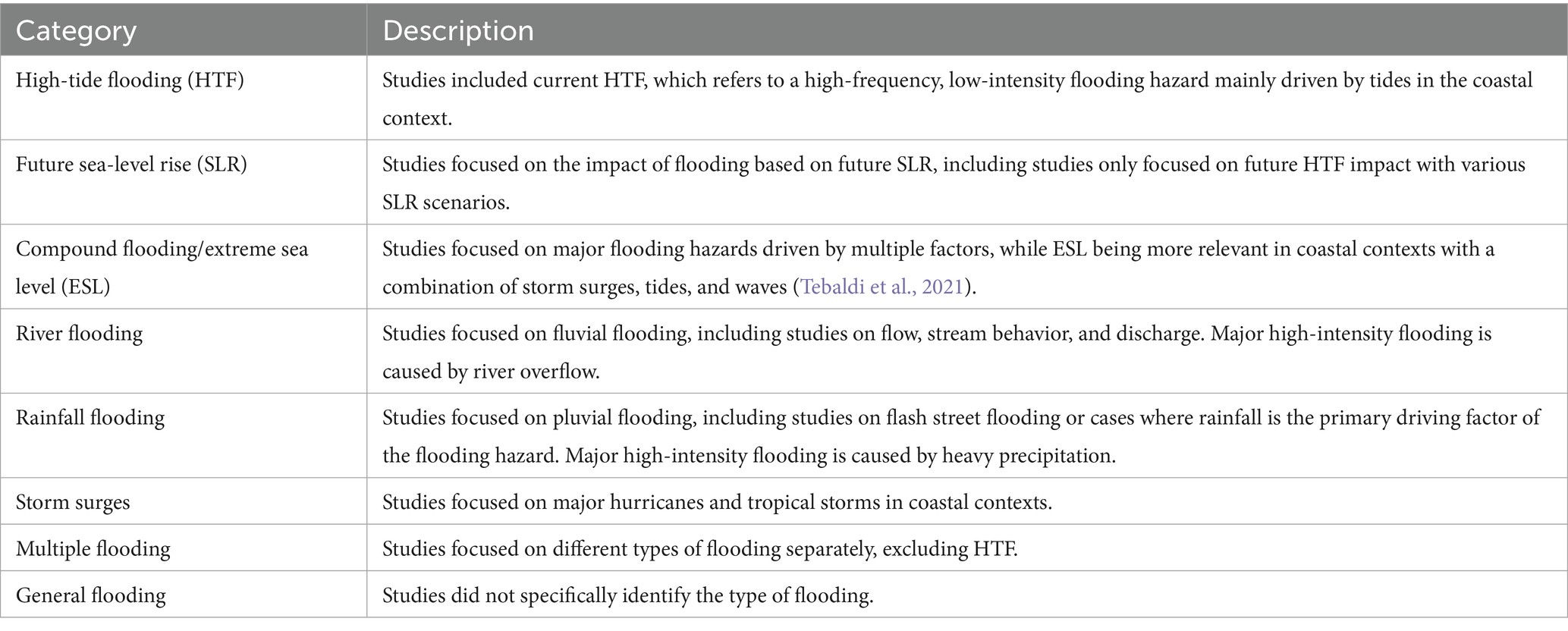
Table 1. Classification of flooding studies used in the systematic review - this table categorizes flooding studies into different types based on their primary focus, with specific criteria for selecting HTF-related studies.
2.2 Identifying HTF related studies
The next step involved identifying and sub-categorizing the HTF-related studies. This review classified all HTF-related studies into three main thematic categories based on their primary research focus: (1) natural and physical aspects, (2) socio-economic impacts, and (3) responses to HTF. The natural and physical category includes studies that examine the physical aspects of HTF hazards, such as frequency, depth, velocity, or future occurrence (Dahl et al., 2017; Hague and Taylor, 2021). This category also includes research on the interactions between HTF and ecosystems or geosystems (Brand et al., 2023). The socio-economic impacts category includes studies that address the impact of HTF on human populations and economic activities, such as a study which evaluated how HTF events cause road closures, increasing local travel times in affected areas (Jacobs et al., 2018). The responses category includes studies that focus on mitigation efforts or adaptive strategies related to addressing HTF risks (Aishwarya et al., 2023; Stephens et al., 2018). For studies that covered more than one category, this review created three additional combined categories to account for overlapping themes. Of the 194 studies that examined present-day HTF, this review identified a total of 51 studies that addressed socio-economic impacts (see Supplementary Table S1), including those with overlapping themes, while 143 did not.
2.3 Analyzing socio-economic impacts of HTF
2.3.1 Geographic distribution and extent
This review examined the geographic distribution and extent of the impacts of HTF events by analyzing the reported study area and spatial scale of analysis of all HTF-related studies categorized under socio-economic impacts. Spatial scale was assigned based on the geographic extent described in each study’s methods section. Based on this analysis, the studies were categorized into three levels: (1) National (covering an entire country), (2) Regional (encompassing an entire state or significant portions thereof), or (3) Local level (focused on a city, county, metropolitan areas, or small island). These categories often correspond to differences in data resolution and availability, with local scale studies often using finer-scale demographic or infrastructure data, while national-scale studies typically rely on coarser datasets (Morrison et al., 2022). Each study’s geographic names and locations were recorded, and the frequency of studies at each spatial scale was analyzed using ArcGIS Pro.
2.3.2 Categorizing socio-economic impact types
Based on a full-text review of each socio-economic HTF study, this review categorized reported impacts into four main sectors: public infrastructure, private property, population, and public health-related environmental contamination (Table 2). The first sector, public infrastructure, includes transportation, drainage, sewage, schools, fire stations, parks, and other important public facilities. Impacts reported in this sector include traffic delays, canceled trips, infrastructure damage, and drainage failures. The private sector includes businesses, homes, and farmland, with associated impacts such as property damage, revenue loss, or devaluation. The human behavior sector includes studies that assess how HTF affects housing choices, daily life routine, and personal economic loss. The final sector of public health-related environmental contamination focuses on issues of water contamination and the spread of pollutants. Subsectors were further identified within each category to better describe the identified impacts in each study. When selected studies reported multiple types of impact, each was reported as a separate observation within the relevant subsectors in this study.
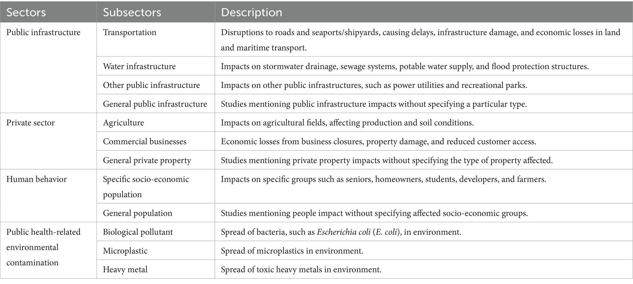
Table 2. Classification of socio-economic exposure sectors and their impacts – this table categorizes the different types of socio-economic exposures to HTF.
2.3.3 Calculating extents and relative scales of HTF impacts
To evaluate the quality of included studies, this review applied a structured classification system based on the quantifiability and comparability of reported socio-economic impacts from HTF. The studies varied widely in their methodological approaches, including qualitative descriptions, survey-based assessments, geospatial modeling, and empirical measurements. In response to this diversity, we developed a three-part framework to assess the reporting format of findings across studies. Specifically, each study was evaluated by asking: (1) whether the HTF impact results were presented in quantitative terms; (2) whether those quantitative values were reported relative to a baseline (e.g., percentage of homes affected); and (3) if not reported explicitly, whether relative values could be derived from the data presented.
Based on this assessment, all HTF studies were classified into four categories (see Supplementary Table S1). Non-quantitative studies presented impacts through descriptive or qualitative formats, such as ethnographic narratives, interview quotes, or photographs (Stephens and DeLorme, 2024). Absolute quantitative studies reported numerical values (e.g., length of road flooded or number of infrastructure units impacted) but lacked information on the total or baseline values needed to interpret the scale of impact (Fant et al., 2021). In contrast, relative quantitative studies either explicitly reported, or non-explicitly allowed us to derive, the proportion or rate of affected units relative to a total (e.g., the percentage of stormwater inlets that failed) (Habel et al., 2020).
In cases where raw numbers were reported, but not explicitly analyzed by the authors, this review calculated relative values using the available data to standardize comparisons across studies. For instance, if a study reported the pre- and post-event volume of sand dunes affected by HTF, the rate of change was calculated to determine the magnitude of impact (Harris and Ellis, 2021). If there was more than one type of measure within a single subsector of observation, we reported the relative values based on each measure. For example, one study reported the percentage of water infrastructure affected by HTF, which included three different measures: percentage of stormwater inlets that failed due to HTF, percentage of cesspools that became non-functional due to HTF, and percentage of cesspools that were fully flooded due to HTF (Habel et al., 2020). This review reported these three relative values separately for this analysis.
To support cross-study comparisons, we report the individual values and value range for all quantitative impacts, separately for absolute impacts and relative change impacts. These values are further categorized by scale, i.e., local, regional or national scale for each country for which these data were available. If a study reported multiple values for a single measure, for example, 3 values for impacts on road closure at a site, we report the average of these values for each measure.
3 Results
3.1 HTF in flooding-related studies
Of the 720 studies that focused on flooding, there were 194 that looked at present-day HTF (Figure 2, Panel A). The second-largest group, totaling 181 studies, were those that examined future SLR. The third largest group of 98 studies focused on compound flooding or extreme sea level (ESL) issues. Storm surge flooding has 71 studies, rainfall has 51, while river flooding has the fewest with 27 studies. Another 22 studies cover multiple flooding hazards but do not mention HTF. Lastly, 76 studies discuss general flooding hazards without specifically targeting any particular type of flooding.
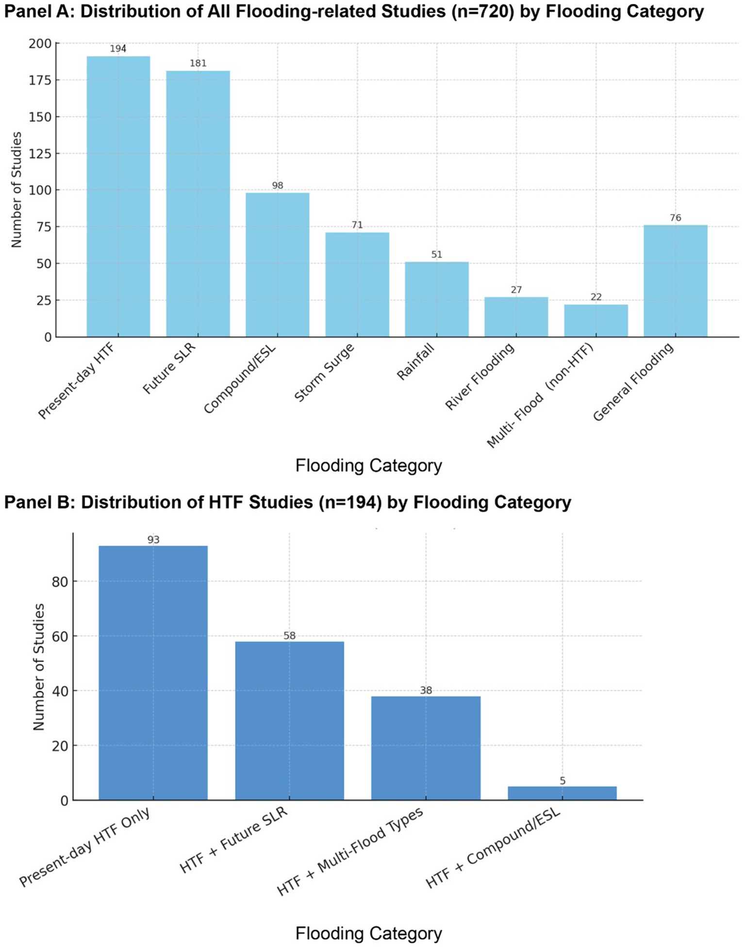
Figure 2. Distribution of studies by flooding category. (A) The distribution of 720 flooding-related studies by category, with Present-day HTF having the most studies, followed by Future SLR. (B) The distribution of 194 studies addressing Present-day HTF, highlighting research that spans from present-day to future contexts.
Among the 194 studies focused on HTF, 93 examined solely current or past HTF, while many others also incorporated broader or future-oriented flood contexts (Figure 2, Panel B). Specifically, 58 studies examined future SLR combined with current HTF conditions, and 38 studies addressed multiple types of flooding beyond HTF alone. A few studies (n = 5) specifically reported HTF in the context of compound flooding or ESL events.
We also analyzed publication years for all identified studies to assess research trends over time (Figure 3). Among the 194 HTF studies, 68% of these studies were published within the last five years (2020 to 2024). Similarly, of the 51 studies focused on socio-economic impacts, 78% were also published during this period.
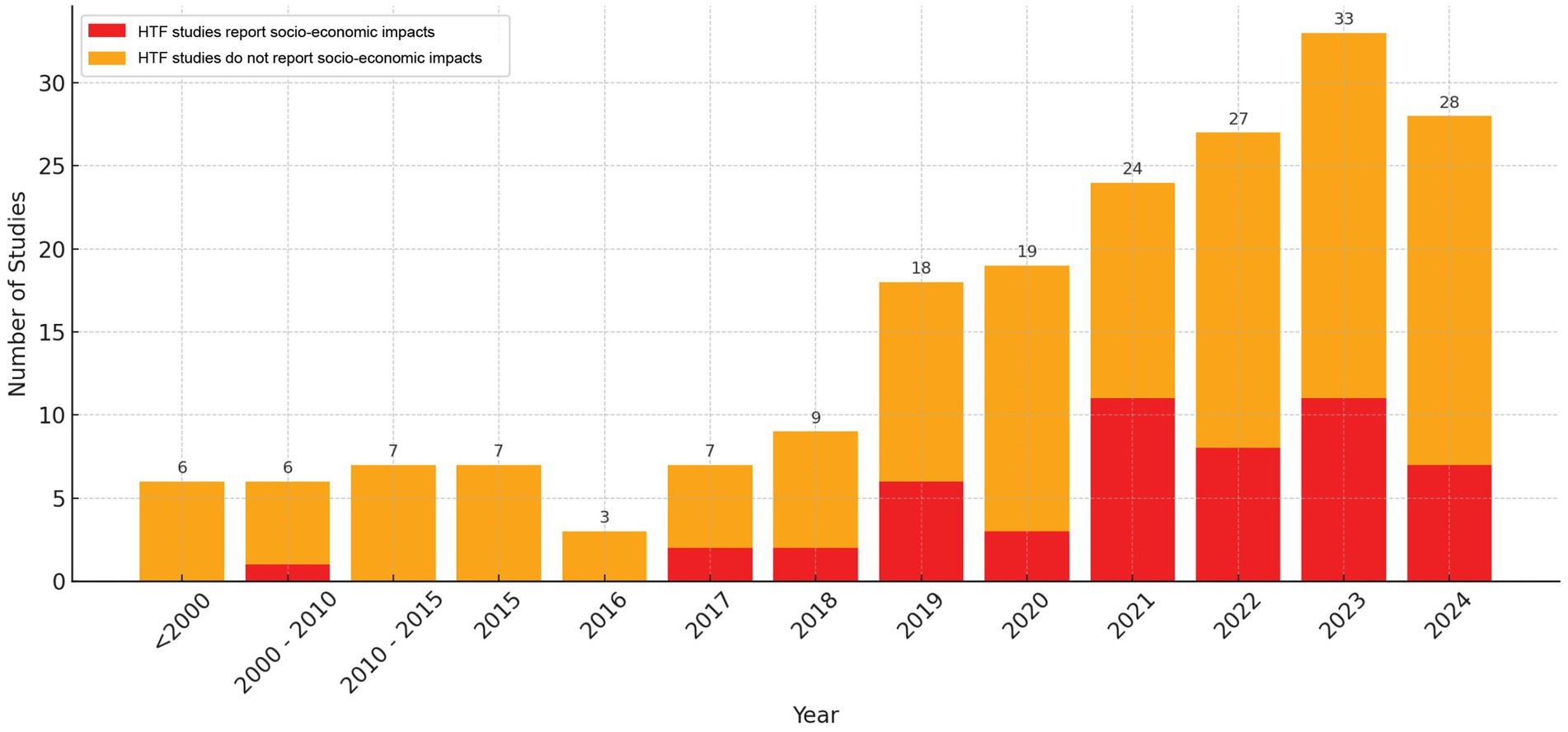
Figure 3. Number of HTF studies published each year up to 2024. The red bars represent studies that specifically examined the socio-economic impacts of HTF, while orange bars indicate the other HTF studies that do not report socio-economic impacts of HTF, the number on top of the bar showing the total number of HTF studies for given year.
3.2 Socio-economic impacts in HTF studies
Among the 194 HTF-focused studies identified, 51 (approximately 26%) addressed the socio-economic impacts of HTF events (see Supplementary Table S1). Of the total HTF-focused studies, 128 studies focused solely on understanding the natural or physical aspects of HTF, 33 examined only the socio-economic impacts, and 12 addressed only response efforts related to HTF. In addition to single-focused studies, 11 studies examined both natural and socio-economic impacts [e.g., understanding saltwater intrusion caused by HTF and its economic impact on crops (Mondal et al., 2023)], three covered natural impacts and response [e.g., developing an adaptation trigger for sea-level rise based on the increasing occurrence of HTF (Stephens et al., 2018)], and three studies covered both socio-economic impacts and response [e.g., investigating how shipyards are impacted by HTF and how they respond to it (Hill et al., 2022)]. Lastly, four studies addressed all three aspects of HTF [e.g., understanding coastal flooding types, including HTF, their impacts on coastal sewage systems, and how people respond to them (Vorhees et al., 2022)] (Figure 4).
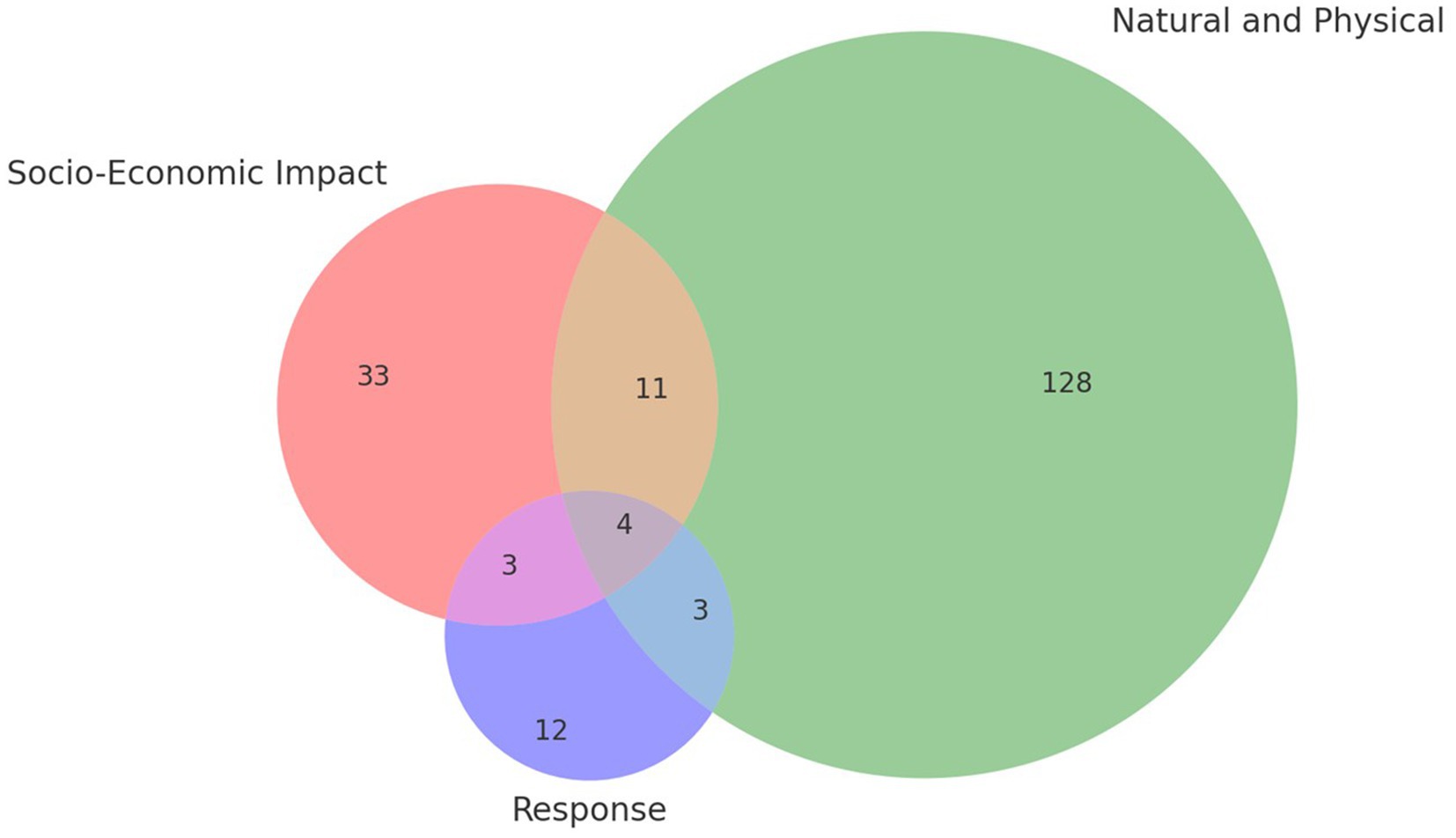
Figure 4. The categorization of HTF studies for all Present-day HTF studies: Socio-Economic Impact (red, 33), Natural and Physical (green, 128), and Response (blue, 12). Overlaps include 11 studies between Socio-Economic and Natural, 3 between Socio-Economic and Response, 3 between Response and Natural, and 4 studies intersecting all three categories.
3.3 Spatial scales, types and relative extents of socio-economic impacts of HTF
3.3.1 Study locations and spatial scales
Of the 51 socio-economic impact HTF studies, 37 examined socio-economic HTF impacts in the U.S., ten in Indonesia, one in the Philippines, one in Italy, one in French Guiana, and one in Mayotte Island (Figure 5). These studies varied widely on spatial scale, with most (42 out of 51) conducted at the local scales and nine conducted at the regional or national level.
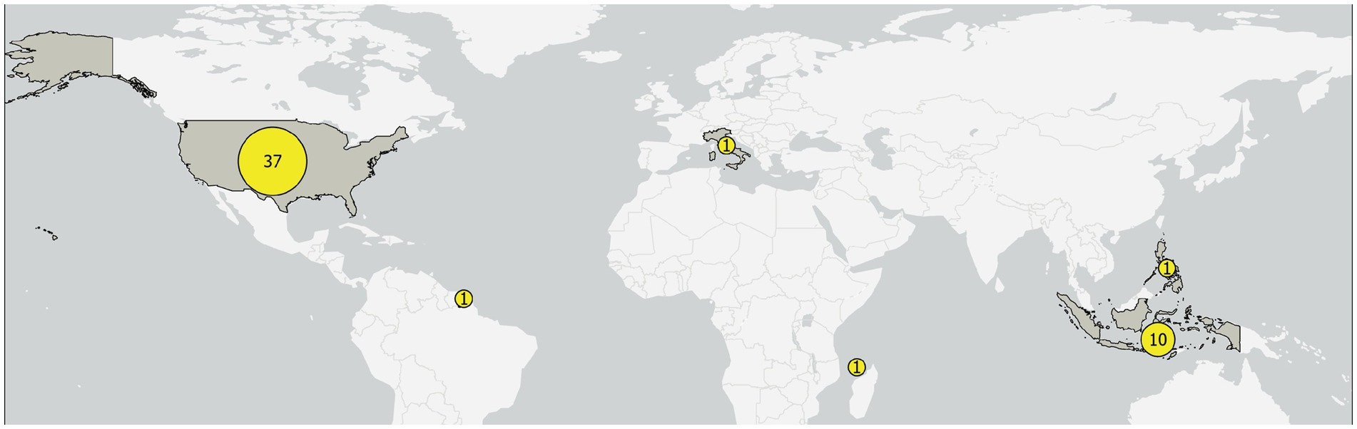
Figure 5. Geographic distribution of studies on HTF socio-economic impacts. Number of HTF studies by country, with yellow dots indicating the count of studies focused on each country.
Given that most socio-economic HTF studies were U.S.-based, we mapped the study sites they covered, which span four coastal regions: the Atlantic Coast, Gulf Coast, Pacific Coast, and Hawaiʻi (Figure 6). These studies span 24 metropolitan areas across 22 U.S. coastal states. For the local studies, the Norfolk (Hampton Roads) Metropolitan Area in Virginia was the most frequently studied location, with nine study counts, followed by the Miami Metropolitan Area in Florida with six study counts. Regionally, the Atlantic Coast of the U.S., particularly the South Atlantic states, has received the most attention in studying the socio-economic impacts of HTF.
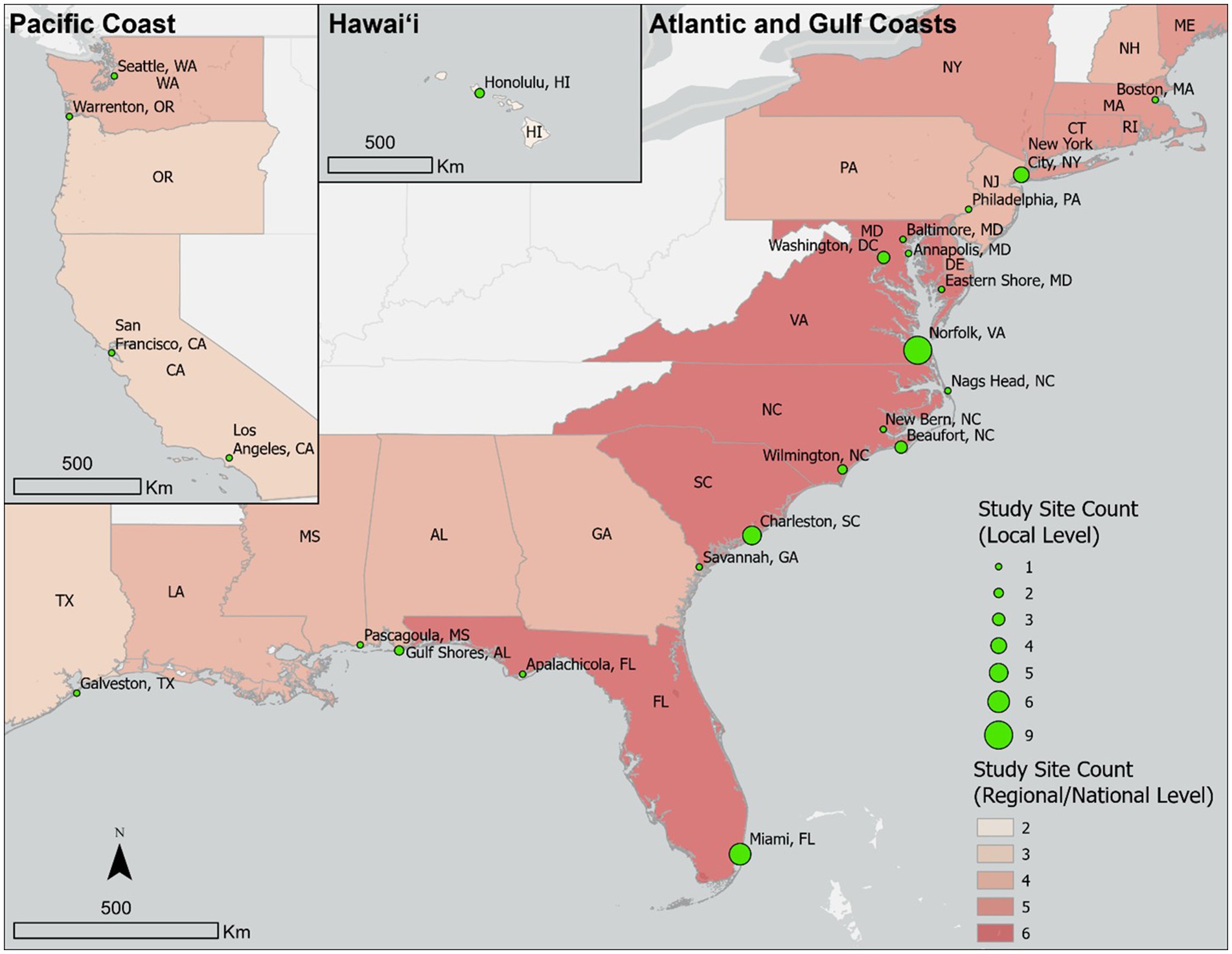
Figure 6. Geographic distribution of HTF study sites in the U.S. The size of each green circle represents the number of studies conducted in that specific location, with Norfolk, VA, and Miami, FL, having the highest numbers. The shading across states indicates the number of regional or national studies that include each state, with darker shades representing higher study counts and showing greater concentrations among Mid-Atlantic states. Pacific Coast and Hawaii regions are shown as insets on the top left.
3.3.2 Categorization of socio-economic impacts of HTF
Among the 51 studies that addressed socio-economic impacts of HTF events, we identified a total of 55 distinct observations of HTF impacts. These observations reflect unique impact types reported across the studies, with some studies contributing more than one observation. This review found 55 observations of HTF impacts across four main socio-economic sectors: public infrastructure (26 observations), private sector (14 observations), human behavior (10 observations), and public health-related environmental contamination (5 observations) (Figure 7, Panel A). Each observation corresponds to a distinct subsector of impact reported in an individual study. Of the 26 public infrastructure observations, 18 were related to transportation, including 16 roads and two seaports/shipyards (Figure 7, Panel B).
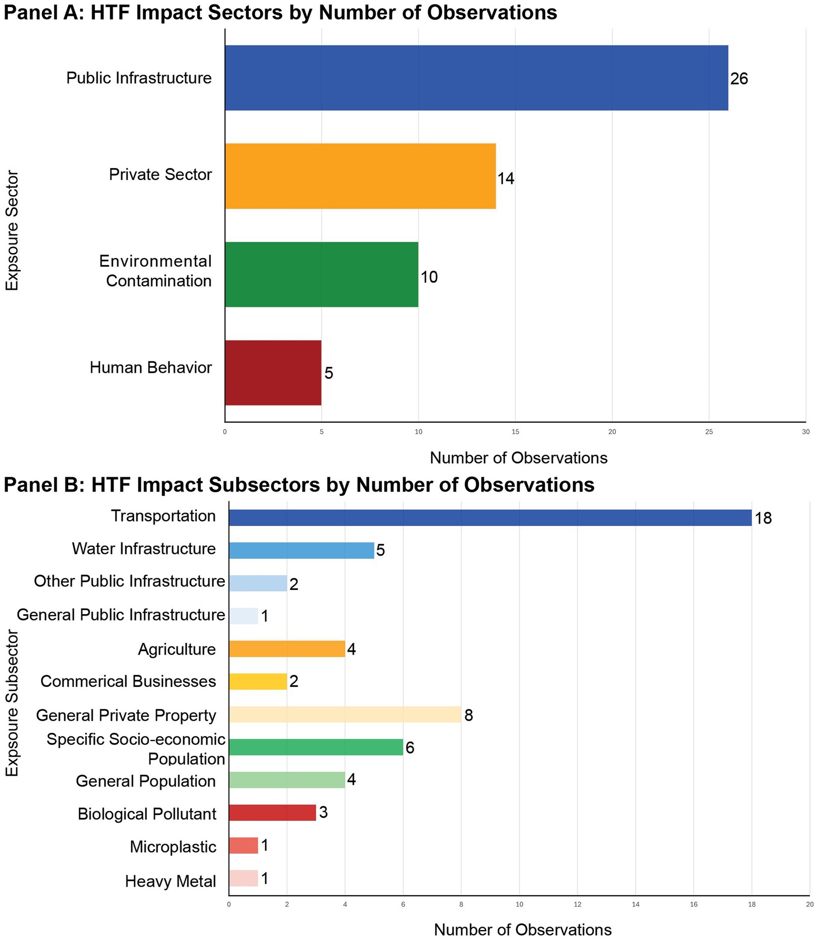
Figure 7. HTF impact sectors and subsectors by number of observations. (A) Distribution of HTF impact sectors based on the number of observations, with public infrastructure being the most frequently studied sector, followed by private sector, human behavior, and environmental contamination. (B) Breakdown of HTF impact subsectors with colors corresponding to the exposure sector (blue – public infrastructure, orange – private sectors, green – human behaviors, and red – public health related environmental contamination).
At the local level, we found that the mid-south Atlantic coast of the U.S. is the most studied region, with HTF impacts reported across nearly all exposure subsectors except agriculture (Figure 8). Specifically, Norfolk, VA, and Charleston, SC are the only two sites that cover all four main impact sectors. In contrast to the Atlantic Coast, which is well represented across multiple sectors and cities, the Gulf Coast and Pacific Coast are notably underrepresented in the HTF literature. In Indonesia, all local-level HTF impact observations related to agriculture were located there. Additionally, we did not find studies addressing health-related environmental contamination in countries outside the U.S.
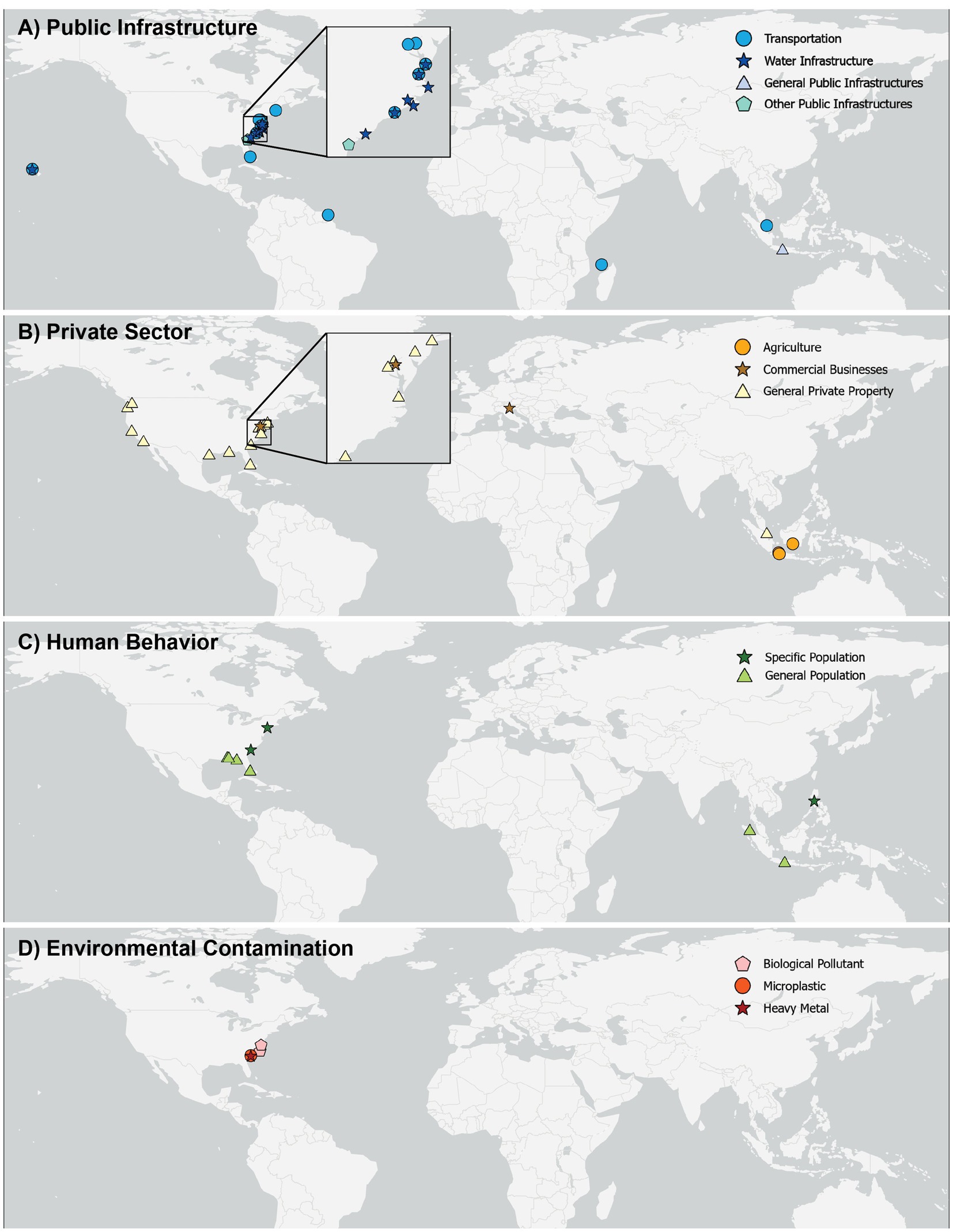
Figure 8. Global distribution of local-scale HTF impact studies by socio-economic subsectors maps show study locations categorized into four main socio-economic sectors: (A) Public infrastructure, (B) Private sector, (C) Human behavior, and (D) Environmental contamination. Each symbol represents one observation, with shapes and colors indicating subsectors within each category. Insets highlight clusters of studies along the U.S. Atlantic coast.
3.3.3 Relative extents of socio-economic impacts of HTF
Each observation refers to a distinct socio-economic impact subsector reported in an individual study. Within a single observation, there may be one or more measures used to describe or quantify the impact. Among the 55 defined HTF impact observations, this review identified a total of 66 values, which include nine non-quantitative descriptions, seven absolute quantitative values, and 50 relative quantitative values. The 50 relative quantitative values include the percentage of total impact from HTF (n = 33) or the rate of increase or decrease of a variable due to HTF (n = 17), which includes both event-driven changes (e.g., increases in contamination) and frequency-driven changes over time (e.g., increases in vehicle delay hours as HTF events become more frequent). These relative impact values vary notably by sector and across spatial scales. To capture this variation, we present the range of values by subsector for the U.S. and Indonesia, where relative impact values are available: HTF impact unit (%) (Figure 9, Panels A and C) and HTF impact change rate (%) (Figure 9, Panel B).
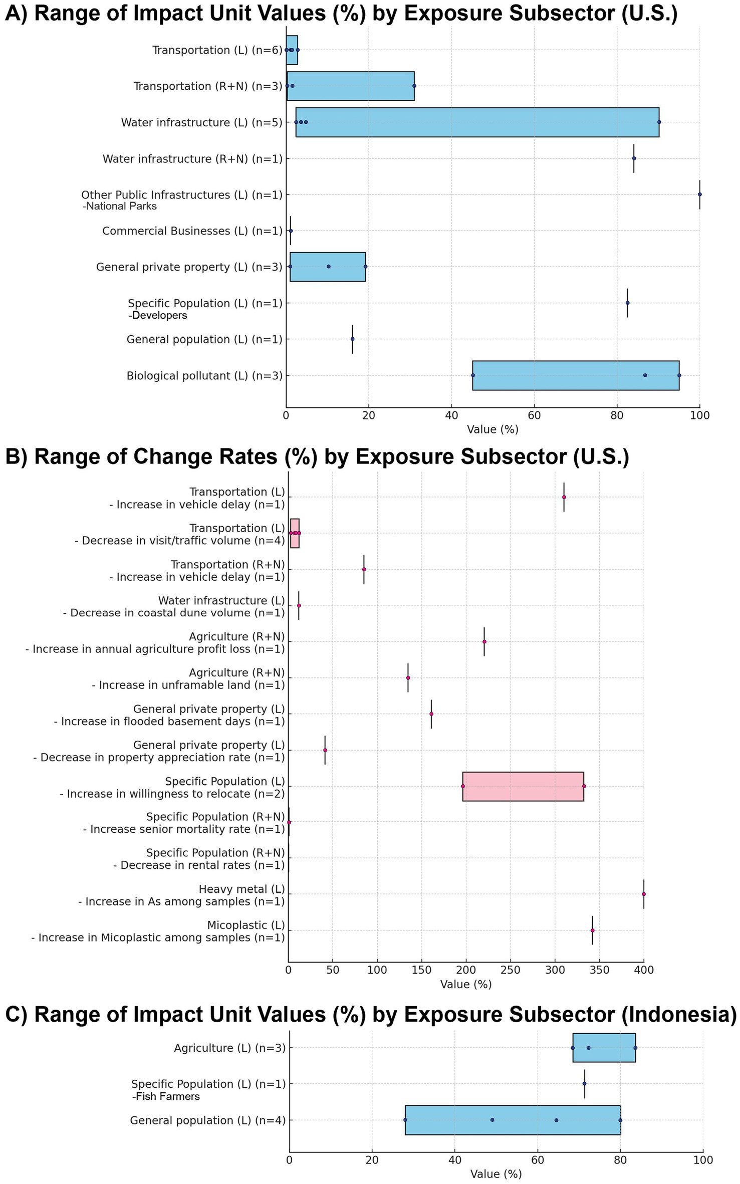
Figure 9. HTF impact sectors and subsectors by number of observations. (A) Distribution of HTF impact sectors based on the number of observations, with public infrastructure being the most frequently studied sector, followed by private sector, human behavior, and environmental contamination. (B) Breakdown of HTF impact subsectors with colors corresponding to the exposure sector (blue – public infrastructure, orange – private sectors, green – human behaviors, and red – public health related environmental contamination).
In the public infrastructure sector, most reported values are related to transportation, commonly measured as the percentage of road length or other transportation infrastructure affected by HTF. At the local level, these values fall within a small range at low percentages, as studies in this category generally use the entire local transportation network as the baseline. For example, one study found no roads in Norfolk, VA were impacted by tide alone, without storm surge or rainfall (Shen et al., 2022). However, this does not mean the area is less affected by HTF, as other studies reported high impact change rates, typically expressed as increases in vehicle delay hours or decreases in visits to specific locations. For instance, in Norfolk, VA, vehicle delay hours increased by 310.0% as a result of HTF (Zahura et al., 2024). For water infrastructure, impacts are typically measured as the percentage of direct exposure or system failure due to HTF. We found a wide range of values at the local level, with one study reporting exceptionally high impacts, where 90.0% of cesspools in Honolulu, HI became non-functional due to HTF (Habel et al., 2020), while other studies reported values between 2.4 and 5.8%.
In the private sector, most studies in the U.S. did not explicitly indicate the type of private sector examined and generally measured impacts as the percentage of properties directly exposed to or damaged by HTF, with values ranging from 1 to 19%. Change rate measurements, however, focused on property value shifts due to HTF and revealed more substantial impacts compared to direct exposure or damage. For example, properties in recurrent HTF areas experienced appreciation rates up to 41.2% lower than those in non-HTF zones (Keenan et al., 2018). In contrast to the U.S., most relative HTF impact values on agriculture were reported from Indonesia. Only one U.S. study addressed agriculture, noting that recurring HTF increased salt patches on the Delmarva Peninsula at regional level, which reduced farmable land and caused economic losses at the regional scale (Mondal et al., 2023). In Indonesia, three studies documented agricultural impacts: on coastal fish farming (Putiamini et al., 2022), salt farming (Nirwansyah and Braun, 2019), and rice fields (Kamil et al., 2024), with unit impact values ranging from 68.5 to 83.6%.
For the human behavior sector, impact values have been reported for specific populations, including renters and homeowners moving out of HTF zones (Buchanan et al., 2019), developers avoiding construction in flood-prone areas (Buckman and Sobhaninia, 2022), and students being unable to attend classes due to HTF (Cadag et al., 2017). Notably, one human behavior-focused study found that HTF disrupted fish farmers’ activities, causing economic losses (Putiamini et al., 2022). When considered alongside three studies on the impacts of HTF on agricultural land, these findings highlight the particular vulnerability of agriculture-related activities in rural coastal communities of Indonesia.
Health-related environmental contamination impact values were reported only in U.S. studies. Unit impact values were expressed as the percentage of collected samples in which biological pollutant abundance exceeded local recreational water use standards, ranging from 45 to 95%. Reported change rates included a 342% increase in microplastics in HTF water samples (Ertel et al., 2023), and a 400% increase in arsenic (As) concentrations in HTF-impacted areas (Squiggins et al., 2024).
At the regional and national scales, transportation impacts show greater variation than at the local level, ranging from 0.2% of travel demand in North Carolina being underserved due to HTF (Fan et al., 2023) to 31% of surveyed shipyard managers identifying HTF as the greatest coastal hazard threat to shipyards (Hill et al., 2022). Human behavior impacts at broader geographic levels appear more limited, with both increases and decreases below 1%. For example, every 2 cm increase in tidal flooding depth raised the mortality rate among individuals aged 65 or older by 0.6% (Mueller et al., 2024). Meanwhile, nationwide rental rates decreased by 0.2% due to HTF (Lee et al., 2023).
4 Discussion
This review analyzes 194 studies published between 1985 and 2024 on high tide flooding (HTF) and its impacts, examining how HTF is defined, the types of socio-economic impacts reported, and their geographic scope and scale. Most studies concentrate on the U.S. Atlantic Coast, with increasing frequency and severity of HTF and its widespread impacts on public infrastructure, private property, vulnerable populations, and environmental quality. To guide interpretation, the discussion is organized into five thematic areas: (1) the relationship between HTF and other coastal flooding drivers, (2) definitional inconsistencies and standardization challenges, (3) geographic gaps and regional underrepresentation, (4) sector-specific socio-economic impacts, and (5) social vulnerability and unequal adaptive capacity.
4.1 HTF in relation to sea-level rise and other flooding types
The publication trend of HTF-focused studies indicates a growing research interest in this topic in recent years (Figure 3). However, recognition of HTF events as a distinct hazard within coastal risk management frameworks remains relatively low. Of the 720 flooding related studies identified through our keyword search, only about 27% explicitly addressed the present-day HTF events (Figure 2).
This review found that HTF is often associated with sea-level rise (SLR) and is often modeled using long-term SLR projections, despite its short-term and localized dynamics. Over 25% (n = 181) of the 720 flood-focused studies reviewed focused primarily flooding related to future SLR, while within the 194 HTF-focused studies, 58 studies (about 30%) also incorporated future SLR scenarios, addressing both present and projected HTF impacts. Over the past two decades, both global and local SLR have increased the frequency of coastal flooding, even in the absence of storms, where high tides alone are capable of inundating streets on clear days (Sweet et al., 2014). Managing the risks from present-day HTF events requires distinguishing their impacts from the projected impacts of future SLR.
In this review, 98 of the 720 (about 14%) studies on flooding focused on compound flooding, with tide frequently considered an important factor in these multi-driver flood scenarios. However, only five studies specifically quantified the contribution of tides to compound flooding, highlighting a gap in how tide-specific impacts are accounted for when modeling compound flood hazards. An additional 71 studies from the HTF keyword search focused on large-scale coastal storms. In these studies, tide was often considered either as a contributing factor in flood risk analysis or as part of the background conditions influencing the increasing risk of coastal storms under rising sea levels (Al-Attabi et al., 2023; Callahan et al., 2022).
Rainfall-induced flooding was the fifth most common focus in the reviewed studies. This may be partly due to the overlapping terminology, words used to describe HTF, such as “nuisance flooding” are also frequently used to describe flooding from non-HTF flood events, most commonly, rainfall-driven event particularly in inland or low-lying urban areas (Canon-Barriga et al., 2023; Hasala et al., 2020; Johnston et al., 2018).
Most HTF-focused studies to date describe the physical drivers of HTF and their impacts on natural systems (Figure 4). This review identified diverse drivers of HTF events, from earthquakes and chronic land subsidence to onshore wind events. Studies on HTF have examined how land subsidence and coastal degradation contribute to increased local tidal variability, leading to more frequent occurrences of HTF (De Leo et al., 2022; Li et al., 2021). Persistent onshore winds can temporarily raise coastal water levels, further elevating high tides and playing a significant role in triggering HTF (Coz et al., 2021; Davies et al., 2022; Thelen et al., 2024). Land subsidence accelerates relative SLR, further increasing the risk of HTF in low-lying coastal areas (Karegar et al., 2017; Le Cozannet et al., 2021; Fiaschi and Wdowinski, 2020). One study also pointed out that earthquakes can lower land elevation, causing land subsidence and relative SLR, which in turn leads to HTF (Jeanson et al., 2021).
4.2 Challenges in defining and standardizing HTF
The lack of standardized HTF definitions across studies remains a challenge, as inconsistent definitions can undermine cross-study comparisons and complicate the understanding, management, and communication of risk from these events. In the U.S., researchers use different criteria to define HTF, with thresholds typically based on physical characteristics, statistical frequency, or expected impact levels. The most widely cited framework comes from NOAA, which proposed national thresholds ranging from 50 to 60 cm above Mean High Higher Water (MHHW) to define HTF, based on empirical observations (Sweet et al., 2018). These thresholds are commonly used in HTF-related socio-economic studies (Jacobs et al., 2018; Fan et al., 2023; Lee et al., 2023), which use NOAA’s HTF extent layers or categorize HTF events between minor and moderate flooding levels. However, many parts of the U.S. rely on local National Weather Service (NWS) thresholds, which are derived from historical water level records and may differ substantially from NOAA’s benchmarks (NOAA, n.d.-a). For instance, the NOAA proposed thresholds are overly generalized and cannot reflect local conditions (Mahmoudi et al., 2024). For example, in Charleston, SC (U.S.), NOAA’s minor flooding threshold is set at 57 cm above MHHW, which exceeds both the local NWS minor threshold (38 cm) and the moderate threshold (53 cm).
In addition to the NOAA’s national and local NWS thresholds, several studies adopt alternative methods to define HTF, that allow for more refined analyses of specific, localized impacts. For example, one study used field observations of traffic disruptions (Hino et al., 2019), while another study proposed impact-based thresholds that consider local topography, pedestrian safety, and potential property damage, ranging from as little as 3 to 10 cm of water depth (Moftakhari et al., 2018). These discrepancies create confusion about whether HTF is classified as a minor-level flooding hazard, which could result in HTF-affected areas not being considered and prioritized when planning coastal hazard adaptation strategies (Federal Emergency Management Agency, 2025).
Outside the U.S., HTF definitions are often rooted in observed physical inundation levels. In Indonesia, where HTF is known as Rob (an Indonesian term meaning “tidal flooding”), it typically refers to tidal flooding between 20 and 50 cm in depth, frequently linked with land subsidence and SLR (Setyowati et al., 2012; Marfai et al., 2008). In Venice, Italy, high tide events known as Acqua Alta (an Italian term meaning “high water”) are considered “intense” when sea level rises to 110 cm above the historical mean (Angelini et al., 2024). While these specific definitions reflect local variations in HTF dynamics, they also complicate comparisons across locations. The use of consistent and well-defined terms and thresholds to describe HTF hazards could help improve the reliability of inter-regional assessments and comparisons of HTF risks (Gall et al., 2009).
4.3 Geographic gaps in HTF research
While HTF events have been observed across North America, South America, Africa, Asia, Australia and Europe, several geographical gaps remain in global observations and measurements of their socio-economic impacts (Figures 5, 8). In countries like Indonesia (Marfai and King, 2008), China (Li et al., 2023), Vietnam (Takagi et al., 2014), India (Krishna et al., 2023), Bangladesh (Haque and Nicholls, 2018), Australia (Hague et al., 2020), and Argentina (Santamaria-Aguilar et al., 2017), that have large populations living below the 10 m elevation contour (Neumann et al., 2015), studies have already reported HTF occurrences in the past and expect an increase in the future SLR. Yet, outside the U.S. we found only Indonesia has multiple HTF impact studies, just one study each in Europe and South America, and no socio-economic impact studies from Africa or the Pacific Ocean region (Figure 5, Panel A and Figure 8). HTF impacts are understudied globally compared to other flood events such as flash floods and storm surges, that have higher immediate and visible impacts (Ramiaramanana and Teller, 2021; Aliyu et al., 2023). The imbalance in study distribution also reflect broader socio-economic disparities between countries, which shape research funding availability and institutional capacity to prioritize emerging hazards such as HTF (Stein et al., 2024). Additionally, this review is limited to English-language literature which might exclude relevant studies conducted in other languages and limit the global geographic scope of this review.
In the U.S., HTF events have been well-studied relative to other countries, however even in the U.S., geographic distribution of current research on the socio-economic impacts of HTF is not equal across the country (Figure 6). Research hotspots for HTF impacts in the U.S. include the Norfolk Area in Virginia, Charleston in South Carolina, and the Miami Metropolitan Area in Florida, likely due to their vulnerability and historical exposure to HTF events (Fiaschi and Wdowinski, 2020; Burgos et al., 2018). Charleston and Norfolk have some of the highest documented relative impacts from HTF across multiple sectors. On the other hand, the Gulf Coast region, which recorded the highest number of tide-driven flooding events in 2020 and is projected to see the most substantial increase in such events over the next 30 years (Sweet et al., 2018; Sweet et al., 2021), has only two out of 31 local level studies addressing socio-economic issues in this region (Moftakhari et al., 2017; Stephens and DeLorme, 2024). Additionally, the Gulf Coast’s higher minority population may be more vulnerable to HTF impacts but potentially less represented in research efforts, due to biases in the availability of funding and data for research projects (Ohenhen et al., 2023).
4.4 Sector-specific socio-economic impacts
Among the socio-economic impacts of HTF, the most studied category is public infrastructure, with the most studied subsector here being transportation (Figure 7). Transportation systems are especially vulnerable because HTF can disrupt community access, posing serious risks for areas with limited alternative routes for evacuation and emergency services (Hauer et al., 2021; Mueller et al., 2024). Although there are no past reports of disrupted emergency services causing fatalities, coastal communities should consider developing response plans to cope with the increasing frequency of HTF due to rising sea levels by the middle of this century (Hague et al., 2023; Sweet et al., 2018). Current studies on HTF impacts on transportation mainly discuss accessibility issues caused by HTF, yet only a few studies have addressed how HTF can physically damage roads and other public transportation infrastructure. For example, prolonged HTF exposure weakens asphalt roads, leading to costly repairs (Martina et al., 2021). On Route 21 N near Hilton Head, SC, repair costs were reported to range between $33,230 and $153,400 per mile annually, depending on the duration of inundation (Fant et al., 2021). Similar challenges are already evident elsewhere in the U.S.: in the Florida Keys, sea level rise and recurrent high tides are undermining roadways and utilities, prompting costly resilience investments (Monroe County, 2022), while in St. Augustine, FL, lawsuits have arisen over efforts to build seawalls, drainage upgrades, and pump stations to address chronic HTF in historic neighborhoods (Sanchez, 2025). These cases demonstrate that even wealthy coastal communities face mounting financial and institutional pressures from HTF. In emerging economies, where budgets are more limited, such recurring costs can become prohibitively high, making it difficult to maintain infrastructure due to poverty, institutional fragility, and limited state capacity, thereby amplifying risk of displacement (Vestby et al., 2024; Lincke and Hinkel, 2021).
Agriculture and daily livelihood disruptions are another critical area of impact, featuring in four out of 14 private sectors and six out of ten specific population focused studies (Figure 6, Panel B). Saltwater intrusion from recurrent HTF increases soil salinity and spreads toxic minerals such as arsenic, leading to crop failure (Sricharoenvech et al., 2024; Izaditame et al., 2022; Tapas et al., 2024; Mondal et al., 2023). In countries like Indonesia and the Philippines, HTF also disrupts daily routines, with studies noting that people may be unable to go to work, attend school, cook, or wash clothes due to recurrent inundation (Cadag et al., 2017; Marfai et al., 2008). Communities in countries with emerging economies are often more vulnerable to HTF than those in developed nations, primarily due to rapid urban expansion, unplanned settlements, and weaker infrastructure and economic foundations (Rufat et al., 2015). Compounding these challenges, limited financial and emergency resources constrain both disaster preparedness and recovery efforts, making it difficult for affected populations to recover and adapt effectively (Hinkel et al., 2014).
HTF can potentially spread pollution in the water, posing a risk to local public health, as identified in five studies (Figure 6). These health risks are particularly severe in areas with outdated infrastructure, such as sewer systems, where floods lead to the spread of toxic materials (Kekeh et al., 2020). We found that there is no study addressing the direct physical injury and mental stress associated with HTF. NOAA recommends that water depths of 6 inches (15 cm) are the maximum safe limit for pedestrians and 1 foot (30 cm) for vehicles (NOAA, n.d.-b). Based on observations of HTF water depth relative to ground level in North Carolina, average depths can reach up to 0.76 feet (23 cm), with a maximum of 1.9 feet (58 cm), posing a hazard to both pedestrians and vehicles (Hino et al., 2025). The dangers are not limited to immediate physical injuries but also extend to long-term physical and mental health impacts. The frequent recurrence of flooding can bring risk of chronic anxiety among affected populations (Terpstra et al., 2006; Campbell et al., 2021).
A key challenge for cross-study synthesis is the lack of standardized, directly comparable measures of HTF impacts. While we present results as ranges (Figure 9), further cross-study comparison was not possible because different studies used different baselines, units, and definitions of HTF. For example, in transportation studies, some reported direct exposure of roads to HTF, while others reported the length of roads experiencing slowdowns due to HTF, making it difficult to combine results into a single metric. Similarly, our “change rate” category included both event-driven changes (e.g., increases in contamination following HTF) and frequency-driven changes over time (e.g., increases in vehicle delay hours as HTF becomes more frequent), which are not strictly comparable across studies. For this reason, we presented the results for each subsector using bar charts to show only the ranges of reported values rather than attempting to generate standardized comparisons. These inconsistencies highlight the need for future research to adopt more consistent baselines to enable comparability across regions and sectors.
4.5 Social and demographic distribution of relative HTF impacts
In addition to variations in absolute observed impacts, our review reveals wide variations in the relative impacts of HTF events by impact sectors and geographic scales (Figure 8). The relative extent of HTF risks to the total exposed people and assets at a location are influenced by multiple factors such as socio-economic conditions and natural landscapes. As a result, regions experiencing frequent HTF require tailored mitigation strategies that address vulnerabilities at the local level (Cutter et al., 2008). At the same time, the variation in impact severity across geographic scales underscores the value of multi-level research and policy approach. Integrating insights from both localized and larger-scale studies, such as done in this review, can lead to more comprehensive flood risk management strategies. While local studies provide critical information for immediate, location-specific actions, regional and national studies help identify broader trends and long-term risks, which are essential for sustainable planning and resource allocation (De Moel et al., 2015).
While there are multiple socio-economic impacts of HTF, there is growing concern about the disproportionate impact of HTF on socially vulnerable populations. As recurrent HTF makes low-elevation properties less desirable, property values in these areas decline, while consumer preferences shift toward higher-elevation neighborhoods (McAlpine and Porter, 2018; Buckman and Sobhaninia, 2022). This dynamic has led to climate gentrification in cities like Miami, FL, where higher-elevation areas are becoming more attractive to buyers retreating from flood-prone zones. This process displaces long-term, lower-income residents, altering community demographics and accelerating economic inequality (Keenan et al., 2018). At the national scale, affordable housing units face rapidly growing exposure to SLR and recurrent flooding, with projections indicating that risk will more than triple by 2050 (Buchanan et al., 2020). These patterns reflect broader concerns about social equity in flood risk management, where socially vulnerable populations, including low-income households, racial minorities, and renters, are more likely to live in flood-prone areas while receiving fewer adaptation resources (Roy and Berk, 2022). While inequity in disaster recovery is well documented (Elliott and Pais, 2006; Kamel, 2012), the unequal burdens of frequent, low-magnitude events such as HTF are only beginning to be recognized. A recent study in Miami, FL, found that higher-income commuters were more likely to adapt by relocating their homes or workplaces to reduce HTF-related commuting delays, a strategy that may not be equally accessible to lower-income groups (Hauer et al., 2021). As research on HTF continues to grow, integrating equity considerations is essential to ensure that adaptation policies do not inadvertently widen existing socio-economic inequities.
5 Recommendations for future research
High-tide flooding (HTF) poses significant socio-economic risks to coastal communities worldwide. This review shows that research on HTF impacts is heavily concentrated in the U.S., often conflated with other flooding types, and inconsistent in scale and sector focus. These limitations underscore the need for more systematic, standardized, and globally representative studies of HTF. We recommend that future studies focus on the following four priorities.
5.1 Clarify HTF event definitions and thresholds
HTF is often conflated with wind-driven flooding, compound events, or long-term sea-level rise scenarios. Consistent definitions and thresholds, harmonized across regions and agencies, are needed to isolate HTF-specific impacts. Developing common definitions is essential to enable cross-regional comparisons and to inform more effective mitigation strategies (Moftakhari et al., 2018).
5.2 Broaden geographic coverage of HTF impact studies
While U.S. Atlantic coastal cities dominate current research, high-risk regions such as the Gulf Coast, Southeast Asia, and Africa remain underrepresented. Expanding studies to these areas will improve the global understanding of HTF impacts.
5.3 Standardize impact baselines for comparability
Comparisons are currently limited because impact metrics use different denominators, such as road length, vehicle delay hours, households, or economic losses. Developing standardized baselines would allow more meaningful synthesis and statistical analysis across regions and sectors.
5.4 Integrate equity considerations
HTF disproportionately affects socially vulnerable populations through unequal exposure, displacement pressures, and limited adaptive resources. Applying equity frameworks can help assess these disparities and guide inclusive adaptation policies, contributing to more equitable and informed decision-making in flood risk mitigation efforts (Roy and Berk, 2022).
Data availability statement
The original contributions presented in the study are included in the article/Supplementary material, further inquiries can be directed to the corresponding author.
Author contributions
YX: Formal analysis, Writing – original draft, Methodology, Software, Data curation, Conceptualization, Resources, Writing – review & editing, Validation, Investigation, Visualization. HS: Conceptualization, Investigation, Writing – original draft, Writing – review & editing, Validation, Methodology. EW: Writing – review & editing, Writing – original draft. F-AH: Writing – review & editing, Writing – original draft. AM: Writing – original draft, Writing – review & editing. SN: Investigation, Supervision, Writing – review & editing, Methodology, Writing – original draft, Funding acquisition, Validation, Conceptualization.
Funding
The author(s) declare that financial support was received for the research and/or publication of this article. This work was supported by East Carolina University’s Integrated Coastal Sciences graduate program and by NOAA under award #NA18OAR4170088.
Conflict of interest
The authors declare that the research was conducted in the absence of any commercial or financial relationships that could be construed as a potential conflict of interest.
Generative AI statement
The authors declare that no Gen AI was used in the creation of this manuscript.
Any alternative text (alt text) provided alongside figures in this article has been generated by Frontiers with the support of artificial intelligence and reasonable efforts have been made to ensure accuracy, including review by the authors wherever possible. If you identify any issues, please contact us.
Publisher’s note
All claims expressed in this article are solely those of the authors and do not necessarily represent those of their affiliated organizations, or those of the publisher, the editors and the reviewers. Any product that may be evaluated in this article, or claim that may be made by its manufacturer, is not guaranteed or endorsed by the publisher.
Supplementary material
The Supplementary material for this article can be found online at: https://www.frontiersin.org/articles/10.3389/fhumd.2025.1644814/full#supplementary-material
References
Aishwarya, N., Aniruddha, K., Sutapa, D., and Bharath, H. (2023). Developing assessment flow for damage estimation of mud housing typology through a case study against coastal floods. Sci. Rep. 13:6712. doi: 10.1038/s41598-023-33468-6
Al-Attabi, Z., Xu, Y., Tso, G., and Narayan, S. (2023). The impacts of tidal wetland loss and coastal development on storm surge damages to people and property: a hurricane Ike case-study. Sci. Rep. 13:4620. doi: 10.1038/s41598-023-31409-x
Aliyu, A., Liman-Hamza, K., and Lawal, A. (2023). Floods in sub-Saharan Africa; causes, determinants and health consequences. Nigerian Med. J. 64:13. Available online at: https://pmc.ncbi.nlm.nih.gov/articles/PMC11180243/
Allen, T., Mcleod, G. M., and Hutt, S. (2021). Sea level rise exposure assessment of U.S. East Coast cargo container terminals. Marit. Policy Manag. 49, 577–599. doi: 10.1080/03088839.2021.1903597
Angelini, F., Figini, P., and Leoni, V. (2024). High tide, low price? Flooding alerts and hotel prices in Venice. Tour. Econ. 30, 876–899. doi: 10.1177/13548166231174270
Bennett, W. G., Karunarathna, H., Xuan, Y., Kusuma, M. S. B., Farid, M., Kuntoro, A. A., et al. (2023). Modelling compound flooding: a case study from Jakarta, Indonesia. Nat. Hazards 118, 277–305. doi: 10.1007/s11069-023-06001-1
Brand, M., Diefenderfer, H., O’Connor, J. E., Borde, A. B., Jay, D., Al-Bahadily, A., et al. (2023). Impacts of a Cascadia subduction zone earthquake on water levels and wetlands of the lower Columbia River and estuary. Geophys. Res. Lett. 50:e2023GL103017. doi: 10.1029/2023GL103017
Buchanan, M. K., Kulp, S., Cushing, L., Morello-Frosch, R., Nedwick, T., and Strauss, B. (2020). Sea level rise and coastal flooding threaten affordable housing. Environ. Res. Lett. 15:124020. doi: 10.1088/1748-9326/abb266
Buchanan, M. K., Oppenheimer, M., and Parris, A. (2019). Values, bias, and stressors affect intentions to adapt to coastal flood risk: a case study from new York City. Weather Clim. Soc. 11, 809–821. doi: 10.1175/WCAS-D-18-0082.1
Buckman, S. T., and Sobhaninia, S. (2022). The impact of sea-level flooding on the real estate development community in Charleston SC: results of a ULI member survey. J. Sustain. Real Estate 14, 4–20. doi: 10.1080/19498276.2022.2095699
Bukvic, A., Borate, A., Hughes, S., Weaver, R., Imburgia, D., and Stiles, W. A. Jr. (2021). Exploring neighborhood‐level resilience to flooding: Why the context and scale matter. J Flood Risk Manag. 14:e12698. doi: 10.1111/jfr3.12698
Burgos, A. G., Hamlington, B. D., Thompson, P. R., and Ray, R. D. (2018). Future nuisance flooding in Norfolk, VA, from astronomical tides and annual to decadal internal climate variability. Geophys. Res. Lett. 45, 12,432–12,439. doi: 10.1029/2018GL079572
Cadag, J. R. D., Petal, M., Luna, E., Gaillard, J., Pambid, L., and Santos, G. V. (2017). Hidden disasters: recurrent flooding impacts on educational continuity in the Philippines. Int. J. Disaster Risk Reduct. 25, 72–81. doi: 10.1016/j.ijdrr.2017.07.016
Callahan, J. A., Leathers, D. J., and Callahan, C. L. (2022). Comparison of extreme coastal flooding events between tropical and midlatitude weather systems in the Delaware and Chesapeake bays for 1980–2019. J. Appl. Meteorol. Climatol. 61, 457–472. doi: 10.1175/JAMC-D-21-0077.1
Campbell, L. K., Cheng, H., Svendsen, E., Kochnower, D., Bunting-Howarth, K., and Wapnitsky, P. (2021). Living with water: documenting lived experience and social-emotional impacts of chronic flooding for local adaptation planning. Cities and the Environment (CATE). 14:38. doi: 10.15365/cate.2021.140104
Canon-Barriga, C., Bogardi, J., and Tischbein, B. (2023). Prioritizing neighborhoods for intervention to mitigate urban small disasters triggered by rainfall. Urban Water J. 20, 1672–1681. doi: 10.1080/1573062X.2022.2026981
Cazenave, A., and Cozannet, G. L. (2014). Sea level rise and its coastal impacts. Earths Future 2, 15–34. doi: 10.1002/2013EF000188
Coz, J., Alsheimer, F., and Lee Lindner, B. (2021). A climatology-based forecast tool for coastal flooding in the low country. J. Appl. Meteorol. Climatol. 60, 893–908. doi: 10.1175/JAMC-D-20-0256.1
Cutter, S. L., Barnes, L., Berry, M., Burton, C., Evans, E., Tate, E., et al. (2008). A place-based model for understanding community resilience to natural disasters. Glob. Environ. Change 18, 598–606. doi: 10.1016/j.gloenvcha.2008.07.013
Dahl, K. A., Fitzpatrick, M. F., and Spanger-Siegfried, E. (2017). Sea level rise drives increased tidal flooding frequency at tide gauges along the U.S. east and gulf coasts: projections for 2030 and 2045. PLoS One 12:e0170949. doi: 10.1371/journal.pone.0170949
Davies, A. R., Smith, J. P., Mandell, D. S., Davis, G., and Wan, F. Y. (2022). Sustained wind forcing and water level anomalies in Annapolis, Maryland. Earth Interact. 26, 52–65. doi: 10.1175/EI-D-21-0013.1
De Leo, F., Talke, S., Orton, P., and Wahl, T. (2022). The effect of harbor developments on future high-tide flooding in Miami, Florida. J. Geophys. Res. Oceans 127:e2022JC018496. doi: 10.1029/2022JC018496
De Moel, H., Jongman, B., Kreibich, H., Merz, B., Penning-Rowsell, E., and Ward, P. J. (2015). Flood risk assessments at different spatial scales. Mitig. Adapt. Strateg. Glob. Change 20, 865–890. doi: 10.1007/s11027-015-9654-z
Dombrowski, T., Pace, R. K., Ratnadiwakara, D., and Slawson, J. V. C. (2020). Deductible choice in flood insurance: who chooses the maximum? J. Hous. Res. 29, S144–S169. doi: 10.1080/10527001.2020.1839320
Elliott, J. R., and Pais, J. (2006). Race, class, and hurricane Katrina: social differences in human responses to disaster. Soc. Sci. Res. 35, 295–321. doi: 10.1016/j.ssresearch.2006.02.003
Elliott, P., and Williams, H. (2021). Evaluating sea-level rise hazards on coastal archaeological sites, Trinity Bay, Texas. J. Island Coast. Archaeol. 16, 591–609. doi: 10.1080/15564894.2019.1701149
Ertel, B. M., Weinstein, J. E., and Gray, A. D. (2023). Rising seas and roadway debris: microplastic and low-density tire wear particles in street-associated tidal floodwater. Mar. Pollut. Bull. 195:115502. doi: 10.1016/j.marpolbul.2023.115502
Fan, H., Miller, R., and Huntsinger, L. (2023). Climate change impacts on North Carolina roadway system in 2050: a systemic perspective on risk interactions and failure propagation. Sustain. Cities Soc. 99:104822. doi: 10.1016/j.scs.2023.104822
Fant, C., Jacobs, J. M., Chinowsky, P., Sweet, W., Weiss, N., Sias, J. E., et al. (2021). Mere nuisance or growing threat? The physical and economic impact of high tide flooding on US road networks. J. Infrastruct. Syst. 27:04021044. doi: 10.1061/(ASCE)IS.1943-555X.0000652
Federal Emergency Management Agency. (2025). Local mitigation planning policy guide (FP-206-21-0002). U.S. Department of Homeland Security. Available online at: https://www.fema.gov/emergency-managers/risk-management/hazard-mitigation-planning
Fiaschi, S., and Wdowinski, S. (2020). Local land subsidence in Miami Beach (FL) and Norfolk (VA) and its contribution to flooding hazard in coastal communities along the U.S. Atlantic coast. Ocean Coast. Manag. 187:105078. doi: 10.1016/j.ocecoaman.2019.105078
Flick, R. E., Chadwick, D. B., Briscoe, J., and Harper, K. C. (2012). “Flooding” versus “inundation”. EOS Trans. Am. Geophys. Union 93, 365–366. doi: 10.1029/2012EO380009
Gall, M., Borden, K. A., and Cutter, S. L. (2009). When do losses count? Bull. Am. Meteorol. Soc. 90, 799–810. doi: 10.1175/2008bams2721.1
Galloway, G. E. (2008). Flood risk management in the United States and the impact of hurricane Katrina. Int. J. River Basin Manag. 6, 301–306. doi: 10.1080/15715124.2008.9635357
Ghanbari, M., Arabi, M., and Obeysekera, J. (2020). Chronic and acute coastal flood risks to assets and communities in Southeast Florida. J. Water Resour. Plan. Manag. 146:04020049. doi: 10.1061/(ASCE)WR.1943-5452.0001245
Habel, S., Fletcher, C. H., Anderson, T. R., and Thompson, P. R. (2020). Sea-level rise induced multi-mechanism flooding and contribution to urban infrastructure failure. Sci. Rep. 10:3796. doi: 10.1038/s41598-020-60762-4
Hague, B. S., Jones, D. A., Jakob, D., Mcgregor, S., and Reef, R. (2022). Australian coastal flooding trends and forcing factors. Earths Future 10. doi: 10.1029/2021EF002483
Hague, B. S., Mcgregor, S., Jones, D. A., Reef, R., Jakob, D., and Murphy, B. F. (2023). The global drivers of chronic coastal flood hazards under sea-level rise. Earths, Future 11:e2023EF003784. doi: 10.1029/2023EF003784
Hague, B. S., Mcgregor, S., Murphy, B. F., Reef, R., and Jones, D. A. (2020). Sea level rise driving increasingly predictable coastal inundation in Sydney, Australia. Earths, Future 8. doi: 10.1029/2020EF001607
Hague, B. S., and Taylor, A. J. (2021). Tide-only inundation: a metric to quantify the contribution of tides to coastal inundation under sea-level rise. Nat. Hazards 107, 675–695. doi: 10.1007/s11069-021-04600-4
Haque, A., and Nicholls, R. J. (2018). Floods and the Ganges-Brahmaputra-Meghna Delta. In: Nicholls, R., Hutton, C., Adger, W., Hanson, S., Rahman, M., Salehin, M. (eds). Ecosystem Services for Well-Being in Deltas. Cham: Palgrave Macmillan. 147–159. doi: 10.1007/978-3-319-71093-8_8
Harris, M. E., and Ellis, J. T. (2021). Comparing tropical cyclone and king tide impacts on a South Carolina coastal dune system. J. Coast. Res. 37, 923–932. doi: 10.2112/JCOASTRES-D-21-00025.1
Hasala, D., Supak, S., and Rivers, L. (2020). Green infrastructure site selection in the Walnut Creek wetland community: a case study from Southeast Raleigh, North Carolina. Landsc. Urban Plann. 196:103743. doi: 10.1016/j.landurbplan.2020.103743
Hauer, M., Mueller, V., Sheriff, G., and Zhong, Q. (2021). More than a nuisance: measuring how sea level rise delays commuters in Miami, FL. Environ. Res. Lett. 16:064041. doi: 10.1088/1748-9326/abfd5c
Hill, D., Becker, A, and Vieira, A. (2022). The U.S. shipbuilding and repair industry’s considerations of coastal hazards resilience - a baseline survey. Maritime Policy Management 51, 323–344. doi: 10.1080/03088839.2022.2138597
Hinkel, J., Lincke, D., Vafeidis, A. T., Perrette, M., Nicholls, R. J., Tol, R. S., et al. (2014). Coastal flood damage and adaptation costs under 21st century sea-level rise. Proc. Natl. Acad. Sci. USA 111, 3292–3297. doi: 10.1073/pnas.1222469111
Hino, M., Anarde, K., Fridell, T., R, M. C., Thelen, T., Farquhar, E., et al. (2025). Land-based sensors reveal high frequency of coastal flooding. Communications Earth Environment 6, 404. doi: 10.1038/s43247-025-02326-w
Hino, M., Belanger, S. T., Field, C. B., Davies, A. R., and Mach, K. J. (2019). High-tide flooding disrupts local economic activity. Sci. Adv. 5:eaau2736. doi: 10.1126/sciadv.aau2736
Hsiao, S.-C., Fu, H.-S., Wu, H.-L., Liang, T.-Y., Chang, C.-H., Chen, Y.-M., et al. (2024). Impact assessment of sea level rise-induced high tide flooding and socioeconomic losses in a highly vulnerable coastal region. J. Hydrol. Reg. Stud. 55:101921. doi: 10.1016/j.ejrh.2024.101921
Hunter, J. (2020). Are tidal predictions a good guide to future extremes? – a critique of the witness King tides project. Ocean Sci. 16, 703–714. doi: 10.5194/os-16-703-2020
Izaditame, F., Siebecker, M. G., and Sparks, D. L. (2022). Sea-level-rise-induced flooding drives arsenic release from coastal sediments. J. Hazard. Mater. 423:127161. doi: 10.1016/j.jhazmat.2021.127161
Jacobs, J. M., Cattaneo, L. R., Sweet, W., and Mansfield, T. (2018). Recent and future outlooks for nuisance flooding impacts on roadways on the U.S. east coast. Transp. Res. Rec. 2672, 1–10. doi: 10.1177/0361198118756366
Jasour, Z. Y., Reilly, A. C., Tonn, G. L., and Ferreira, C. M. (2022). Roadway flooding as a bellwether for household retreat in rural, coastal regions vulnerable to sea-level rise. Clim. Risk Manag. 36:100425. doi: 10.1016/j.crm.2022.100425
Jeanson, M., Anthony, E. J., Charroux, S., Aubry, A., and Dolique, F. (2021). Detecting the effects of rapid tectonically induced subsidence on Mayotte Island since 2018 on beach and reef morphology, and implications for coastal vulnerability to marine flooding. Geo-Mar. Lett. 41. doi: 10.1007/s00367-021-00725-4
Johnston, M. C., Guishard, M. P., Peñate, I., and Currie, I. D. (2018). Flooding threshold rainfall events in Bermuda. Weather 73, 290–294. doi: 10.1002/wea.3096
Kamel, N. (2012). Social marginalisation, federal assistance and repopulation patterns in the New Orleans metropolitan area following hurricane Katrina. Urban Stud. 49, 3211–3231. doi: 10.1177/0042098011433490
Kamil, I., Jayadi, R., and Rahardjo, A. P. (2024). Impact of climate change on inundation in the Katingan tidal agricultural lowland, Central Kalimantan. ASEAN Eng. J. 14, 197–206. doi: 10.11113/aej.v14.20495
Karegar, M. A., Dixon, T. H., Malservisi, R., Kusche, J., and Engelhart, S. E. (2017). Nuisance flooding and relative sea-level rise: the importance of present-day land motion. Sci. Rep. 7:11197. doi: 10.1038/s41598-017-11544-y
Keenan, J. M., Hill, T., and Gumber, A. (2018). Climate gentrification: from theory to empiricism in Miami-Dade County, Florida. Environ. Res. Lett. 13:054001. doi: 10.1088/1748-9326/aabb32
Kekeh, M., Akpinar-Elci, M., and Allen, M. J. (2020). Sea level rise and coastal communities In: R. Akhtar, (eds). Extreme weather events and human health (Cham: Springer). doi: 10.1007/978-3-030-23773-8_12
Krishna, P. S., Tiju, V., Nair, L. S., and Ramesh, M. (2023). Coastal flooding by wave, wind, tide interactions and related processes along the southern part of SW coast of India. Reg. Stud. Mar. Sci. 62:102968. doi: 10.1016/j.rsma.2023.102968
Le Cozannet, G., Idier, D., De Michele, M., Legendre, Y., Moisan, M., Pedreros, R., et al. (2021). Timescales of emergence of chronic flooding in the major economic center of Guadeloupe. Nat. Hazards Earth Syst. Sci. 21, 703–722. doi: 10.5194/nhess-21-703-2021
Lee, S., Wan, X., and Zheng, S. (2023). Estimating the indirect cost of floods: evidence from high-tide flooding. (2023). MIT center for real estate research paper no. 23/10. doi: 10.2139/ssrn.4506951
Li, S., Wahl, T., Fang, J., Liu, L., and Jiang, T. (2023). High-tide flooding along the China coastline: past and future. Earths Future 11:e2022EF003225. doi: 10.1029/2022EF003225
Li, S., Wahl, T., Talke, S. A., Jay, D. A., Orton, P. M., Liang, X., et al. (2021). Evolving tides aggravate nuisance flooding along the U.S. coastline. Sci. Adv. 7:eabe2412. doi: 10.1126/sciadv.abe2412
Lincke, D., and Hinkel, J. (2021). Coastal migration due to 21st century sea-level rise. Earths Future 9. doi: 10.1029/2020EF001965
Macías-Tapia, A., Mulholland, M. R., Selden, C. R., Loftis, J. D., and Bernhardt, P. W. (2021). Effects of tidal flooding on estuarine biogeochemistry: quantifying flood-driven nitrogen inputs in an urban, lower Chesapeake Bay sub-tributary. Water Res. 201:117329. doi: 10.1016/j.watres.2021.117329
Macmanus, K., Balk, D., Engin, H., Mcgranahan, G., and Inman, R. (2021). Estimating population and urban areas at risk of coastal hazards, 1990–2015: how data choices matter. Earth Syst. Sci. Data 13, 5747–5801. doi: 10.5194/essd-13-5747-2021
Mahmoudi, S., Moftakhari, H., Muñoz, D. F., Sweet, W., and Moradkhani, H. (2024). Establishing flood thresholds for sea level rise impact communication. Nat. Commun. 15:4251. doi: 10.1038/s41467-024-48545-1
Marfai, M. A., and King, L. (2008). Tidal inundation mapping under enhanced land subsidence in Semarang, Central Java Indonesia. Nat. Hazards 44, 93–109. doi: 10.1007/s11069-007-9144-z
Marfai, M. A., King, L., Sartohadi, J., Sudrajat, S., Budiani, S. R., and Yulianto, F. (2008). The impact of tidal flooding on a coastal community in Semarang, Indonesia. Environment 28, 237–248. doi: 10.1007/s10669-007-9134-4
Martina, N., Hasan, M., Setiawan, Y., and Yanuarini, E. Analysis of the use of rubber waste to improve the performance of the asphalt concrete mixture against tidal floods. IOP Conference Series: Earth and Environmental Science, (2021). IOP Publishing, 012005.
Mcalpine, S. A., and Porter, J. R. (2018). Estimating recent local impacts of sea-level rise on current real-estate losses: a housing market case study in Miami-Dade, Florida. Popul. Res. Policy Rev. 37, 871–895. doi: 10.1007/s11113-018-9473-5
Mechler, R., Czajkowski, J., Kunreuther, H., Michel-Kerjan, E., Botzen, W., Keating, A., et al. (2014). Making communities more flood resilient: The role of cost benefit analysis and other decision-support tools in disaster risk reduction. White Paper, Zurich Flood Resilience Alliance. Available online at: https://pure.iiasa.ac.at/id/eprint/11193/ (Accessed September 9, 2014).
Moftakhari, H. R., Aghakouchak, A., Sanders, B. F., Allaire, M., and Matthew, R. A. (2018). What is nuisance flooding? Defining and monitoring an emerging challenge. Water Resour. Res. 54, 4218–4227. doi: 10.1029/2018WR022828
Moftakhari, H. R., Aghakouchak, A., Sanders, B. F., and Matthew, R. A. (2017). Cumulative hazard: the case of nuisance flooding. Earths Future 5, 214–223. doi: 10.1002/2016EF000494
Mondal, P., Walter, M., Miller, J., Epanchin-Niell, R., Gedan, K., Yawatkar, V., et al. (2023). The spread and cost of saltwater intrusion in the US mid-Atlantic. Nat. Sustain. 6, 1352–1362. doi: 10.1038/s41893-023-01186-6
Monroe County (2022). Monroe County Roadway Vulnerability Study Final Report. Florida: Michael Baker International for Monroe County. Available online at: https://www.monroecounty-fl.gov/803/Sustainability
Morrison, D., Beevers, L., Wright, G., and Stewart, M. D. (2022). The impact of data spatial resolution on flood vulnerability assessment. Environ. Hazards 21, 77–98. doi: 10.1080/17477891.2021.1912694
Mueller, V., Hauer, M., and Sheriff, G. (2024). Sunny-day flooding and mortality risk in coastal Florida. Demography 61, 209–230. doi: 10.1215/00703370-11153911
Nederhoff, K., Crosby, S. C., Van Arendonk, N. R., Grossman, E. E., Tehranirad, B., Leijnse, T., et al. (2024). Dynamic modeling of coastal compound flooding hazards due to tides, extratropical storms, waves, and sea-level rise: a case study in the Salish Sea, Washington (USA). Water 16:346. doi: 10.3390/w16020346
Neumann, B., Vafeidis, A. T., Zimmermann, J., and Nicholls, R. J. (2015). Future coastal population growth and exposure to sea-level rise and coastal flooding - a global assessment. PLoS One 10:e0118571. doi: 10.1371/journal.pone.0118571
Nirwansyah,, and Braun, (2019). Mapping impact of tidal flooding on solar salt farming in northern Java using a hydrodynamic model. ISPRS Int. J. Geo Inf. 8:451. doi: 10.3390/ijgi8100451
NOAA. (n.d.-a). Coastal Inundation Dashboard. Available online at: https://tidesandcurrents.noaa.gov/inundationdb/ (Accessed July 4 2024).
NOAA. (n.d.-b). Turn around, Don’t drown! Available online at: https://www.weather.gov/tsa/hydro_tadd#:~:text=*%20Do%20not%20walk%20through%20moving,ground%20in%20front%20of%20you (Accessed July 7 2024).
Ohenhen, L. O., Shirzaei, M., Ojha, C., and Kirwan, M. L. (2023). Hidden vulnerability of US Atlantic coast to sea-level rise due to vertical land motion. N. Commun. 14:2038. doi: 10.1038/s41467-023-37853-7
Page, M. J., Mckenzie, J. E., Bossuyt, P. M., Boutron, I., Hoffmann, T. C., Mulrow, C. D., et al. (2021). The PRISMA 2020 statement: an updated guideline for reporting systematic reviews. BMJ n71. doi: 10.1136/bmj.n71
Paulik, R., Stephens, S., Wild, A., Wadhwa, S., and Bell, R. G. (2021). Cumulative building exposure to extreme sea level flooding in coastal urban areas. Int. J. Disaster Risk Reduct. 66:102612. doi: 10.1016/j.ijdrr.2021.102612
Peter Sheng, Y., Paramygin, V. A., Yang, K., and Rivera-Nieves, A. A. (2022). A sensitivity study of rising compound coastal inundation over large flood plains in a changing climate. Sci. Rep. 12, 3403. doi: 10.1038/s41598-022-07010-z
Putiamini, S., Mulyani, M., Patria, M. P., Soesilo, T. E. B., and Karsidi, A. (2022). Social vulnerability of coastal fish farming community to tidal (rob) flooding: a case study from Indramayu, Indonesia. J. Coast. Conserv. 26:7. doi: 10.1007/s11852-022-00854-7
Ramiaramanana, F. N., and Teller, J. (2021). Urbanization and floods in sub-Saharan Africa: spatiotemporal study and analysis of vulnerability factors—case of Antananarivo agglomeration (Madagascar). Water 13:149. doi: 10.3390/w13020149
Reimann, L., Vafeidis, A. T., and Honsel, L. E. (2023). Population development as a driver of coastal risk: current trends and future pathways. Cambridge Prisms 1, 1–23. doi: 10.1017/cft.2023.3
Roy, M., and Berke, P. (2022). Social equity, land use planning, and flood mitigation. Oxford Res. Encyclop. Environ. Sci. doi: 10.1093/acrefore/9780199389414.013.822
Rufat, S., Tate, E., Burton, C. G., and Maroof, A. S. (2015). Social vulnerability to floods: review of case studies and implications for measurement. Int. J. Disaster Risk Reduct. 14, 470–486. doi: 10.1016/j.ijdrr.2015.09.013
Sanchez, Y. (2025). City of St. Augustine files eminent domain lawsuit against property owners amid flood mitigation project dispute. News4JAX. Available online at: https://www.news4jax.com/news/local/2025/07/02/city-of-st-augustine-files-eminent-domain-lawsuit-against-property-owners-amid-flood-mitigation-project-dispute/
Santamaria-Aguilar, S., Schuerch, M., Vafeidis, A. T., and Carretero, S. C. (2017). Long-term trends and variability of water levels and tides in Buenos Aires and Mar del Plata, Argentina. Front. Mar. Sci. 4:380. doi: 10.3389/fmars.2017.00380
Schneider, S., Rasul, R., Liu, B., Corry, D., Lieberman-Cribbin, W., Watson, A., et al. (2019). Examining posttraumatic growth and mental health difficulties in the aftermath of hurricane Sandy. Psychol. Trauma Theory Res. Pract. Policy 11, 127–136. doi: 10.1037/tra0000400
Setyowati, D. L., Amin, M., and Astuti, T. M. P. Ishartiwi (2012). Community efforts for adaptation and anticipate to flood tide (ROB) in Bedono Village, district Sayung Demak, Central Java, Indonesia. Man India. 97, 241–252. Available online at: https://www.researchgate.net/profile/Dewi-Setyowati-2/publication/317756009_Community_efforts_for_adaptation_and_anticipate_to_flood_tide_ROB_in_Bedono_Village_District_Sayung_Demak_Central_Java_Indonesia/links/607ea73c881fa114b414fc71/Community-efforts-for-adaptation-and-anticipate-to-flood-tide-ROB-in-Bedono-Village-District-Sayung-Demak-Central-Java-Indonesia.pdf
Shen, Y., Tahvildari, N., Morsy, M. M., Huxley, C., Chen, T. D., and Goodall, J. L. (2022). Dynamic modeling of Inland flooding and storm surge on coastal cities under climate change scenarios: transportation infrastructure impacts in Norfolk, Virginia USA as a case study. Geosciences. 12, 224. doi: 10.3390/geosciences12060224
Spanger-Siegfried, E., Dahl, K., Caldas, A., Udvardy, S., Cleetus, R., Worth, P., et al. (2017). When rising seas hit home: Hard choices ahead for hundreds of U.S. coastal communities. Union of Concerned Scientists. Available online at: https://www.ucsusa.org/resources/when-rising-seas-hit-home
Spanger-Siegfried, E., Fitzpatrick, M. F., and Dahl, K. (2014). Encroaching tides: How sea level rise and tidal flooding threaten U.S. East and Gulf Coast communities over the next 30 years. Union of Concerned Scientists. Available online at: https://www.ucsusa.org/resources/encroaching-tides
Squiggins, K. T., Fullerton, H., and Vulava, V. M. (2024). The presence of ampicillin-resistant coliforms in urban floodwaters of a coastal city in the southeastern United States. Front. Water 6. doi: 10.3389/frwa.2024.1359196
Sricharoenvech, P., Siebecker, M. G., Tappero, R., Landrot, G., Fischel, M. H., and Sparks, D. L. (2024). Chromium speciation and mobility in contaminated coastal urban soils affected by water salinity and redox conditions. J. Hazard. Mater. 462:132661. doi: 10.1016/j.jhazmat.2023.132661
Stein, L., Mukkavilli, S. K., Pfitzmann, B. M., Staar, P. W. J., Ozturk, U., Berrospi, C., et al. (2024). Wealth over woe: global biases in hydro-hazard research. Earths, Future 12. doi: 10.1029/2024EF004590
Stephens, S. A., Bell, R. G., and Lawrence, J. (2018). Developing signals to trigger adaptation to sea-level rise. Environ. Res. Lett. 13:104004. doi: 10.1088/1748-9326/aadf96
Stephens, S. H., and Delorme, D. E. (2024). Incorporating lived experience narratives into interdisciplinary environmental communication projects: a technique for better environmental communication. Environ. Sci. Pol. 160:103855. doi: 10.1016/j.envsci.2024.103855
Sweet, W. V. (2014). Sea level rise and nuisance flood frequency changes around the United States, US Department of Commerce, National Oceanic and Atmospheric Administration.
Sweet, W., Dusek, G., Obeysekera, J., and Marra, J. J. (2018). Patterns and projections of high tide flooding along the US coastline using a common impact threshold.
Sweet, W., Simon, S., Dusek, G., Marcy, D., Brooks, W., Pendleton, M., et al. (2021). 2021 State of High Tide Flooding and Annual Outlook. NOAA technical report NOS CO-OPS 086. doi: 10.7289/V5/TR-NOS-COOPS-086
Takagi, H., Van Ty, T., and Thao, N. D. (2014). Investigation on floods in can Tho City: influence of ocean tides and sea level rise for the Mekong Delta’s largest city In Coastal disasters and climate change in Vietnam (Elsevier). 257–274. doi: 10.1016/B978-0-12-800007-6.00012-5
Tapas, M. R., Etheridge, R., Finlay, C. G., Peralta, A. L., Bell, N., Xu, Y., et al. (2024). A methodological framework for assessing sea level rise impacts on nitrate loading in coastal agricultural watersheds using SWAT+: a case study of the tar-Pamlico River basin, North Carolina, USA. Sci. Total Environ. 951:175523. doi: 10.1016/j.scitotenv.2024.175523
Tebaldi, C., Ranasinghe, R., Vousdoukas, M., Rasmussen, D. J., Vega-Westhoff, B., Kirezci, E., et al. (2021). Extreme Sea levels at different global warming levels. Nat. Clim. Chang. 11, 746–751. doi: 10.1038/s41558-021-01127-1
Terpstra, T., Gutteling, J. M., Geldof, G. D., and Kappe, L. J. (2006). The perception of flood risk and water nuisance. Water Sci. Technol. 54, 431–439. doi: 10.2166/wst.2006.573
Thelen, T., Anarde, K., Dietrich, J. C., and Hino, M. (2024). Wind and rain compound with tides to cause frequent and unexpected coastal floods. Water Res. 266:122339. doi: 10.1016/j.watres.2024.122339
Thompson, P. R., Widlansky, M. J., Hamlington, B. D., Merrifield, M. A., Marra, J. J., Mitchum, G. T., et al. (2021). Rapid increases and extreme months in projections of United States high-tide flooding. Nat. Clim. Chang. 11, 584–590. doi: 10.1038/s41558-021-01077-8
Vestby, J., Schutte, S., Tollefsen, A. F., and Buhaug, H. (2024). Societal determinants of flood-induced displacement. Proc. Natl. Acad. Sci. USA 121. doi: 10.1073/pnas.2206188120
Vorhees, L., Harrison, J., O’Driscoll, M., Humphrey, J. R. C., and Bowden, J. (2022). Climate change and onsite wastewater treatment systems in the coastal Carolinas: perspectives from wastewater managers. Weather Clim. Soc. 14, 1287–1305. doi: 10.1175/WCAS-D-21-0192.1
Wong, T. E., Sheets, H., Torline, T., and Zhang, M. (2022). Evidence for increasing frequency of extreme coastal sea levels. Front. Clim. 4:796479. doi: 10.3389/fclim.2022.796479
Keywords: high-tide flooding, systematic review, socio-economic impacts, sea-level rise, global
Citation: Xu Y, Sirianni H, Wade E, Hoover F-A, Mukherji A and Narayan S (2025) A global systematic review of socio-economic impact assessments of high-tide flooding. Front. Hum. Dyn. 7:1644814. doi: 10.3389/fhumd.2025.1644814
Reviewed by:
Chen Zeng, Zhongnan University of Economics and Law, ChinaMiyuki Hino, University of North Carolina at Chapel Hill, United States
Edited by:
Ashfak Ahmad Khan, Karabük University, TürkiyeCopyright © 2025 Xu, Sirianni, Wade, Hoover, Mukherji and Narayan. This is an open-access article distributed under the terms of the Creative Commons Attribution License (CC BY). The use, distribution or reproduction in other forums is permitted, provided the original author(s) and the copyright owner(s) are credited and that the original publication in this journal is cited, in accordance with accepted academic practice. No use, distribution or reproduction is permitted which does not comply with these terms.
*Correspondence: Yicheng Xu, eHV5MjBAc3R1ZGVudHMuZWN1LmVkdQ==
†Senior author
‡ORCID: Yicheng Xu, https://orcid.org/0009-0000-2475-1528
Hannah Sirianni, https://orcid.org/0000-0002-3951-9630
Eric Wade, https://orcid.org/0000-0001-5458-5911
Fushcia-Ann Hoover, https://orcid.org/0000-0002-9067-0504
Anuradha Mukherji, https://orcid.org/0000-0003-2315-7062
Siddharth Narayan, https://orcid.org/0000-0002-7635-3879