 Martina Angela Caretta
 Rodrigo Fernandez2†
- 1Human Geography Department, Lund University, Lund, Sweden
- 2Region360-Environic Foundation International, Washington, DC, United States
- 3Forestry and Natural Resources Department, West Virginia University, Morgantown, WV, United States
- 4Geology and Geography Department, West Virginia University, Morgantown, WV, United States
The hydrosocial (HS) and social-hydro (SH) frameworks each attempt to understand the complexity of water and society, but they have emerged from historically disparate fields with distinctly different goals as well as methodological and epistemological standpoints. This paper encapsulates the shared experiences of two human geographers and two hydrologists studying hazard and vulnerability in two communities impacted by extreme flooding in West Virginia in 2016. We add to the limited examples of scientists working across epistemologies to improve the understanding of water-societal relations. In so doing, we also contribute to broader discussions of water justice. We outline an experimental approach connecting hydrosocial and social-hydro frameworks to study flood hazard and vulnerability. Within our conceptualization, we set forth that while social and hydrological factors can be presented as purely anthropogenic or geophysical, respectively, their intersection is the crux to investigate. The relationships between variables of both major categories can help us understand how the social and biophysical systems are interrelated. We depart from 21 semi structured interviews and a secondary analysis of local biophysical factors to develop a model that could show the relations between social and biophysical factors. Linking these factors is crucial step toward integration of SH and HS approaches to create a more comprehensive understanding of water-human relations. These studies can inform policymakers by highlighting where negative connections can be remedied and positive connections can be fostered to emphasize water justice.
Introduction
Studies of water justice demand interdisciplinary scientific collaborations that connect hydro-climatological data and context-specific socioeconomic and cultural findings. Bringing together data from diverse perspectives allows for a more comprehensive and potentially novel analytical approach to understanding water-induced vulnerabilities, which contribute to water justice (Zwarteveen and Boelens, 2014). With this end goal in mind and a common scientific interest in vulnerability to floods, we, two human geographers and two hydrologists, strived to work through our epistemological, ontological and methodological differences to assess flood hazards and vulnerability. This paper illustrates our process of knowledge construction across disciplines, via an experimental modeling approach, in an attempt to contribute to the scientific understanding of and the societal debate on flood hazard and vulnerability.
This collaboration was grounded on the understanding that floods cannot be engaged from solely a social or physical science framework (e.g., Seidl and Barthel, 2017; Wesselink et al., 2017). The study of flooding is urgent, as floods are the leading cause of natural disaster deaths worldwide (Rufat et al., 2015; Hu et al., 2018; Tellman et al., 2020; Ray et al., 2021) and flood impacts are expected to worsen in the future due to climate change (Wasko and Sharma, 2017; Hettiarachchi et al., 2018; Papalexiou and Montanari, 2019). Over the past 30 years, floods have caused an annual damage average of $8.2 billion in the United States alone (Wing et al., 2018). Recent estimates suggest ~42 million Americans live in floodplains with a 99% probability of flooding every year, representing $2.9 trillion in exposed goods and property (Wing et al., 2018).
Floods are influenced by a myriad of physical factors (e.g., atmospheric circulation, land use/land cover), and flood causes and impacts are inherently human in nature (Sivapalan et al., 2012). Two concurrent approaches have emerged to study the complexity of the human-water dynamics: sociohydrology (SH) and hydrosociology (HS). Both approaches examine factors relevant to human-water systems by placing humans as central to the water cycle. Despite their shared goals, they differ in their ontology, epistemology, axiology, and methodology (Wesselink et al., 2017). SH departs from a positivist and objectivist position, and, with a few exceptions (Gober and Wheater, 2014; Liu et al., 2014), uses quantitative, coupled human-water models to explore the co-evolution of people and water across scales (e.g., Di Baldassarre et al., 2013, Di Baldassarre et al., 2019), with the goal of prediction to support strategic water management and governance (Sivapalan et al., 2012). SH studies are often conducted by mono-disciplinary teams that do not incorporate social scientists (e.g., Pande and Sivapalan, 2017). SH studies strive to consider society endogenous to the hydrological system, although society is often simplified as one actor rather than a dynamic assemblage of physical and social variables embedded within the system (e.g., Seidl and Barthel, 2017). This reductionist approach is undertaken in order to assign quantitative relationships between variables with the goal of predicting the behavior of a sociohydrological system in time (Lane, 2014). As a result, SH misses fundamental aspects of the hydrosocial cycle that the hydrosociology (HS) approach seeks to capture, particularly those related to social vulnerability and unequal power relations.
Hydrosociology (HS) tends to focus on critical and qualitative examinations of dynamic social-ecological relationships and investigates how water and society make and remake each other over time and space (Linton and Budds, 2014; Wesselink et al., 2017). HS studies tend to focus on particular case studies, often at smaller scales than SH studies (c.f. Ferdous et al., 2018). While HS can be applied at the watershed-scale (c.f. Carey et al., 2014), it is more often used to understand water-society relationships at the scale of a community or neighborhood. HS approaches are grounded in critical, contextual, and reflexive epistemology, which is often outside the positivist paradigm of sociohydrology (Wesselink et al., 2017). However, given their situatedness in socioenvironmental relations, HS studies leave out large spatial scales and temporal interactions, limiting the ability to generalize its findings (Linton, 2012).
By the same token, SH studies attempt to quantitatively represent human-water interactions through dynamic models and differential equations, over-generalizing and often leaving out contextual and cultural dimensions of human-environment interactions (Di Baldassarre et al., 2013; Ross and Chang, 2020). This approach runs the additional risk of limiting the understanding of water problems as purely natural, depoliticizing and demoting them outside public discourse and policy-making (Zwarteveen and Boelens, 2014). HS is different from SH in that it understands knowledge as creating or even performing realities, rather than embodying it; it interrogates the situatedness of the researcher in the process of knowledge construction and it questions whether holism—as argued by SH—is possible, given that abstractions do not necessarily mirror the complexity of reality.
Aware of these limitations and in search of collaborative ground, we approach the study of floods hazard and vulnerability through the disciplinary toolboxes closest to our areas of expertise. Human geographers Caretta and Shinn used a hydrosocial perspective and hydrologists Fernandez and Zegre used a sociohydrological one. In 2017, when these conversations started, we were all based at West Virginia University, where a deadly flood had occurred in 2016 in the southern part of state. Given our employment at a land grant institution, our shared conviction that science should be done to inform citizens and policy makers, and with a commitment to emphasizing water justice in the state, this event represented an opportunity for us to participate in ongoing public debates over what makes communities vulnerable and how they can better prepare themselves if such a disaster takes place again. We entered these discussions because we wanted to learn from each other's perspectives and intended to address the issue in a holistic way. Caretta and Shinn wanted to move beyond an overly contextual case study approach to scale up and be able to compare their findings to inform a more comprehensive and policy-relevant understanding of floods hazard and vulnerability. Fernandez and Zegre wanted to advance the mere “add demography to biophysical factors” sociohydrology modeling approach and to heed to the call for reflexively in sociohydrology (Lane, 2014) to critically account for the role of society in flood hazards and vulnerability (see also Khajehei et al., 2020 and Lindersson et al., 2020). It quickly became apparent that our toolboxes were partial and skewed, which presented frustrating limitations.
However, despite our different approaches, we shared the same goals and objectives. We all understood that science is not neutral and that our methodological choices are partial and subjective. Living in a state with a long history of extraction, resulting in numerous water-related disasters, and working at a land grant institution admired by West Virginians, we appreciated that our work on such a tragic event could resonate through the media (see e.g., Pytalski, 2018; Cook, 2019, and West Virginia University Eberly College of Arts Sciences, 2020) and reach the public. The study could eventually inform policy makers to increase flood disaster awareness and water justice. With this in mind, we attempted to work through our epistemological and ontological differences and draw inspiration from other academics before us who have advocated for the collaboration between sociohydrologists and social scientists concerned with water-society relations and sociohydrologists (Carey et al., 2014; Lane, 2014; Wesselink et al., 2017). Our axiology, originally narrow and skewed by our own ontologies, quickly broadened and became more complex as we engaged with each other's perspectives.
There are few examples that demonstrate how scientists from disparate epistemologies can co-produce integrated experimental approaches that transcend barriers to create meaningful research that advances understanding of the coupled human-water system (e.g., Landström et al., 2011; Ferdous et al., 2018). Additionally, as Seidl and Barthel (2017, p. 452) note, “the literature is largely silent concerning how the integration will occur.” One exception is Carey et al. (2014), who argue for trans-disciplinary collaborations that recognize the importance of social sciences in hydrology and suggest that the next step is to design a hydrological model that can incorporate human variables. Inspired by this piece, we iteratively worked to create a model derived from original qualitative data in a way that could show the relationships and the feedbacks between the different natural, technical, societal and cultural components that are constitutive of flood hazard and vulnerability. While we recognize others are working at the intersection of physical and critical social sciences (c.f. Lave et al., 2014), we find that Carey et al. (2014) and Di Baldassarre et al. (2013) provided an understandable roadmap that related most directly to questions of vulnerability and flooding, while also leaving space for elaborating the models based on our case study. This paper recounts how we worked toward an experimental modeling approach to more appropriately account for the relevant factors and feedbacks that lead to and are generated by increased vulnerability, with the goal of emphasizing water justice in relation to flooding.
First, we outline the strengths and weaknesses of each framework. Second, we present the case study and the methodology used to analyze the 2016 floods in West Virginia (WV). Third, departing from Carey et al. (2014) and Di Baldassarre et al. (2013), we identify relevant categories of analysis and outline qualitative data obtained through fieldwork and interviews with residents, authorities, and community organizations. Fourth, we present a model linking these categories. In so doing, we provide an example of how we are working to overcome disciplinary divisions between social scientists and hydrologists. We conclude by exploring how the presented approach can be useful for interdisciplinary research projects that seek to examine the complex relationships between water and society, with relevance for questions of flooding and water justice far beyond Appalachia.
Overview of HS and sh Approaches
The Hydrosocial Cycle
Swyngedouw (1999) argues that although the hydrological cycle has been conceptualized as complex, multifaceted, and global, it has mostly been approached from hydrological, economic and engineering perspectives, which omit crucial societal dimensions of water. The hydrosocial literature originates from the idea that flows of water and the social processes that govern them are not separate entities but rather are comprised of hydrosocial arrangements (Budds, 2008, Linton, 2008; Linton and Budds, 2014). In line with more recent work on water justice (c.f. Zwarteveen and Boelens, 2014), the hydrosocial cycle is a framework through which to investigate the relational and dialectical nature of the physical and social dimensions of water over space and time (Linton, 2010; Linton and Budds, 2014, Boelens et al., 2016), as well as the power relations embedded in hydrosocial configurations (Swyngedouw, 1999). Given these dialectical power relations, the HS framework is grounded on a critical, subjective epistemology that accounts for the role and biases of the researcher in the process of knowledge construction. In other words, nature-society relations are seen through subjective lenses (Wesselink et al., 2017). This concept has gained traction in the social sciences, and particularly in human geography, over the last decade because of its ability to integrate biophysical elements of water with the social realm of water use and the power relations that govern access in everyday life.
Importantly, HS approach has also contributed to the understanding of water justice by exploring and unveiling where power relations have contributed to causing disasters, often erroneously presented as “natural.” Along these lines, Budds and Hinojosa-Valencia (2012) use of the concept of waterscape to add an explicit scalar dimension to the hydrosocial cycle by showing how water governance at different levels is characterized by a diverse set of flows, forms, practices, and discourses. In their work on mining in Peru, they used the concept of “waterscape” to problematize how sociopolitical processes shape the physical flow of water while also showing how technologies and institutions make this flow possible. In a similar vein, Swyngedouw (1999) uses an example from modernizing Spain to show how water and its management for production purposes have created social privilege and exclusion, a phenomenon that cannot be captured by a mere engineering conceptualization of water. Rather, water and society have a dialectical relationship that is expressed in material, ideological, and representational ways (e.g., through engineering, policy, and through water as a signifier of purity; Swyngedouw, 1999). In these ways, it becomes clear that water and society cannot be understood as discreet components of a larger cycle but rather must be understood as intersecting variables that are continuously shaping and reshaping each other.
Linton and Budds (2014) outline three specific ways in which water and society intersect to shape each other over space and time. First, processes of water management require institutions to organize around water resources and to cyclically restructure depending on the availability of water (Boelens et al., 2016). Second, technology related to the distribution of water shapes diverse set of power relations (e.g., fountain in a public square versus a commercial, bottled-water vending machine). Third, water is an active component that shapes and disrupts social relations across time and space in both predictable and unpredictable ways (Shinn, 2016). HS scholarship highlights that by framing these disruptions as “natural,” such events are falsely rendered as apolitical, masking how they are also the outcome of specific power relations. While geographers and other scientists have shown the importance of cultural and contextual aspects of the hydrosocial cycle (Boelens et al., 2016), lack of attention to temporal scale is a major shortcoming of HS (Linton, 2012). As such, increased attention is needed toward how water disrupts social relations across time.
Carey et al. (2014) presents a conceptual model to study relations between humans and water and their interplay through the case of water resource availability in the Peruvian Andes. Using the HS concept, Carey et al. (2014) examined downstream cryosphere water resource availability and climate change of Peruvian Cordillera. Instead of relying solely on climatically determined model simulations of water supply below glaciers, they also explored human variables that affect water use practices and hydrology (e.g., policy, land use, economic, and technological development). As physical factors like runoff conformed to model projections of climate and glacier storage, they found that societal dynamics established legal, economic, political, cultural, and social conditions that shaped water use patterns through human modifications of watersheds.
Sociohydrology
Traditional hydrology research has long taken a problem-focused approach to understand the human impact on hydrological systems, considering opportunities and constraints faced by society due to changes in water (Wesselink et al., 2017). In this sense, human-induced drivers of water resources are prescribed as external forcings of water cycle dynamics under assumptions of stationarity.
The need to place humans as endogenous to the water cycle has been known for some time as evidenced by the existence of other “coupled” fields of study such as hydrosociology and hydroeconomics (Pande and Sivapalan, 2017). From the hydrology perspective, the importance of people within the water system gained popularity with the concept of integrated water resources management (IWRM) and the issues it highlights and attempts to resolve. Originally, it focused on controlling or managing the water system to reach specified outcomes for society and the environment. Hydrologists and water engineers approached IWRM through scenario-based approach to explore interactions (see Savenije and Van der Zaag, 2008). However, scenario-based approaches may be unrealistic, especially for long-term predictions, since they do not account for the temporally dynamic interactions and explicit representation of co-evolution, including spontaneous or unexpected behaviors (Sivapalan et al., 2012; Blöschl et al., 2019).
Stemming from the birth of sociohydrology circa 2012 (Sivapalan et al., 2012), hydrologists have started to incorporate human interactions into numerical models to understand the feedbacks between physical and societal systems (Wesselink et al., 2017). In sociohydrology, researchers “attempt to capture all human-nature interactions in a mathematical, holistic system model by means of mathematical expressions” (Wesselink et al., 2017, p. 3), with the aim of predicting the dynamics of both (Pande and Sivapalan, 2017). Socio-hydrology is framed as a discovery-based fundamental science whose practice is informed through observing, understanding, and predicting socio-hydrologic phenomena in real places in the landscape where real people live (Pande and Sivapalan, 2017). It has largely developed its own conceptualization of how water interacts across biophysical and societal processes (Wesselink et al., 2017) and its subsequent methodologies that parameterize and predict interactions and feedbacks of the coupled human-water system. Sociohydrology strives to be a quantitative science. While broad narratives may be important for context, quantitative descriptions are needed for testing hypotheses, modeling the systems, and predicting possible future trajectories of the system states.
Pande and Sivapalan (2017, p. 6) offer a generic framework for the implementation of scientific inquiry to explore feedbacks in coupled human–water systems. The framework is predicated on the “generation of knowledge of possible processes that contribute to the generation of observed phenomena,” and “historical or contemporary data that allows researchers to compare and contrast the performance of phenomena simulated through mathematical models.” The feedbacks implicit to a given coupled human–water system can be studied by identifying gaps in contemporary understanding of the system through the iterative process of hypothesis building, data evidence, and subsequent hypothesis updating. Sociohydrology is a recently defined area of research hence, domains and concepts are still in the developing and hypothesis building stage of co-evolution within water systems (Ferdous et al., 2018).
Floods are a main area of research for sociohydrology due in part to the feedback between levels of flood protection and vulnerability (e.g., Di Baldassarre et al., 2013; Pande and Sivapalan, 2017). SH models have been developed under a comparative framework between rivers with flood protection infrastructure and rivers without. These models usually use a hypothetical prototype for each case and study flood impacts on population and economy. However, in their attempt to quantify anthropogenic factors within physical hydrological factors, simplifications are needed to discretize processes into equations. In doing so, broader interactions such as power relations and social vulnerabilities are left out of SH analysis.
Using the SH framework, Di Baldassarre et al. (2015) examine flood risks by explicitly accounting for mutual interactions and feedbacks between floods and society using dynamic modeling and differential equations. They considered various physical and social factors (e.g., societal memory, demography on the floodplain) rooted in hydrology, demography, technology, and society domains.
Departing from these HS and SH frameworks, we sought a shared understanding of water-societal relations using a case study of the West Virginia 2016 floods. We drew on Carey et al. (2014) and Di Baldassarre et al. (2013) to try to find common conceptual ground where we could learn from each other, strive to overcome the limitations of our respective entry points, and accept that no one approach would fully depict the complexity of the phenomenon we were trying to untangle.
Methodology
In 2016, floods ravaged communities in southern West Virginia (Figure 1). With steep topography, narrow valleys and intense rainfalls that frequently exceed 100 mm in a 24-h period (Ehlke et al., 1982), West Virginia is prone to flooding. Between 1991 and 2016, each of West Virginia's 55 counties experienced floods (FEMA, 2016). Flooding is exacerbated by a long history of natural resources extraction including forest harvesting, agriculture, and coal mining that alter the partitioning of precipitation into runoff, storage, and evaporation (e.g., Zégre et al., 2013). Furthermore, due to complex topography, many communities in West Virginia reside in steep and narrow valleys with narrow floodplains. Because of the location of homes and infrastructure, West Virginia has experienced several catastrophic floods in addition to those in 2016, including ones in 1985 and 1972 (United States Geological Survey, 1988).
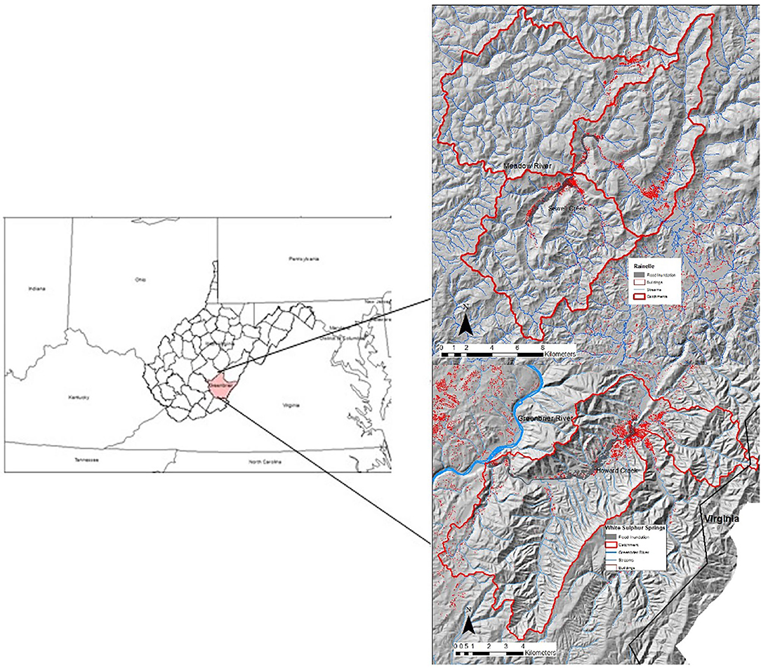
Figure 1. Study site location map of Greenbrier, County, West Virginia, USA and the communities of Rainelle and White Sulfur Springs impacted by the June 23, 2016 floods.
Early in the morning of June 23, 2016, several sequential bands of torrential thunderstorms made their way across central and southeastern West Virginia. Over the course of the following 24 h, total rainfall amounted to 200–250 mm, ~25% of annual rainfall (FEMA, 2016). Peak flow was the highest on record at seven locations, and streamflow ranked in the top five for the period of record at 18 locations of U.S. Geological Survey streamflow gaging stations (Austin et al., 2018). The storm was estimated to have a 100-year return interval (Di Liberto, 2016), and caused major flooding in four counties. Twenty-three lives were lost, 1,500 houses and 125 business were destroyed, and 4,000 homes were deemed impaired. Overall damages from the storm were valued in excess of $1 billion (US dollars) (Di Liberto, 2016). The greatest impacts were experienced in Greenbrier County, with large areas of several communities inundated by flood water. Following the floods, 4,951 Individual Assistance Applications were submitted and $42 million were awarded, in addition to $117 million through Total Public Assistance Grants (FEMA, 2016). This study focuses on two communities hit particularly hard by the floods (Figure 1): Rainelle, located in western Greenbrier County and situated at the confluence of three creeks that feed the Meadow River, and White Sulfur Springs, located in the eastern part of the county along Howard Creek, a tributary to the Greenbrier River.
This event became the catalyst for our collaboration and the case study through which we attempted to improve our reciprocal disciplinary entry points to understanding flood hazard and vulnerability and how they relate to broader issues of water justice.
Approximately one year after the floods, Caretta and Shinn carried out 21 interviews in these two communities in southern West Virginia to understand local residents' lived experiences of the floods and the recovery process. Voice-recorded interviews, which spanned from 45 to 120 min, were conducted with residents, authorities, and community organizations. After fieldwork and following common social science methodological norms (Leavy and Saldana, 2014), interviews were transcribed, hand-coded for recurring themes, and analyzed using the qualitative analysis software NVivo 12. Through this qualitative methodological approach, Shinn and Caretta were able to discern the crucial role that charity and religious organizations played in the post-floods recovery (Shinn and Caretta, 2020).
However, because of the intrinsic limitations of a purely qualitative approach, Caretta and Shinn were not able to corroborate and validate what interviewees believed had caused the floods. Residents of Rainelle and White Sulfur Springs spoke of clogged stormwater infrastructures; debris; clear cut forest harvesting; the frequency of flooding; and how they thought the local topography and the specific heavy precipitation events had worsened already deteriorating local infrastructural and social conditions. In total, out of 21 interviews, there were 80 references to these themes. Lack of stormwater management and the role of forest clear cutting were the most frequently mentioned reasons for the severity of flood impacts.
In an attempt to more comprehensively assess what interviewees had recounted, these results were shared with Fernandez and Zegre, who used two federal reports by FEMA (2016) and the USGS (Austin et al., 2018) to understand the physical factors that led to flooding and flood inundation, including information on terrain, weather, land cover, and infrastructure. FEMA (2016) summarizes in a descriptive manner the development and occurrence of the June 23–24, 2016 storm that led to the deadly flooding and provides a forensic analysis by compiling spatiotemporal data from different government agencies that describe the hydroclimatological and geographical characteristics of Greenbrier County. The report provides flood risk maps generated by insurance agencies. The information from this report was validated through various media reports, white papers, and analyses of observed meteorological and hydrological data (Beck and Kersey, 2016; MetroNews West Virginia, 2016; NOAA National Weather Service, 2016; Watson and Cauller, 2017; NOAA National Centers for Environmental Information, 2021; US Geological Survey, 2021). Furthermore, Austin et al. (2018) reconstructed flood inundation by collecting high water marks and calculated peak-flow magnitudes, frequencies, and probabilities. The interviews increased validity of that data by providing local and temporal insights of the floods that otherwise would have been missed by a traditional hydrological flood analysis. The interviews also made apparent that, although the meteorological and hydrological phenomena were of extreme magnitudes, the floods were exacerbated by anthropogenic factors, namely, failing infrastructure (see results section).
Having gathered secondary data on the physical factors that led to flooding, including flood inundation, terrain, land cover, and infrastructure, we started to wrestle with the ways in which we could present a potentially more complete picture of flood hazard and vulnerability in West Virginia. Through several conversations that spanned over a year, we became acquainted with our reciprocal entry points of HS and SH and found that the Carey et al. (2014) and Di Baldassarre et al. (2013) works could be a starting point to develop an experimental model that could possibly encapsulate the social and biophysical relations leading to and generating from flood disaster.
Working from these previous models [Di Baldassarre et al., 2013 (Figure 2) and Carey et al., 2014 (Figure 3)], we took an experimental approach to develop a model (Figure 4) with categories built on data gathered from interviews with residents, emergency responders, and authorities (see also Ferdous et al., 2018). Both of the aforementioned models account for similar processes though conceptualized at different scales.
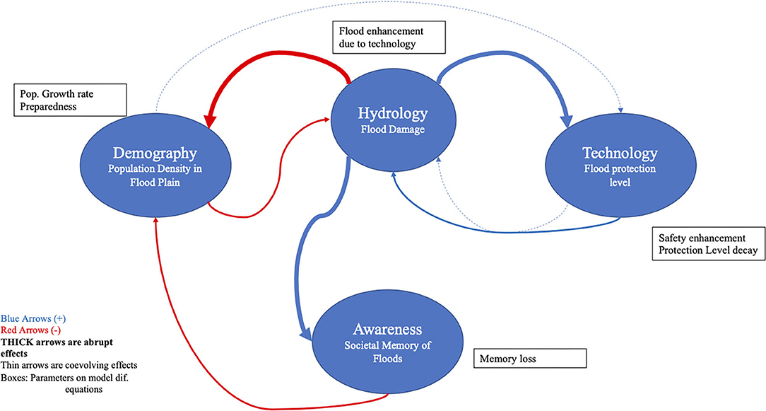
Figure 2. Conceptual model by Di Baldassarre et al. (2013) of hydrological and social factors that compose the hazard and vulnerability components of a flood disaster.
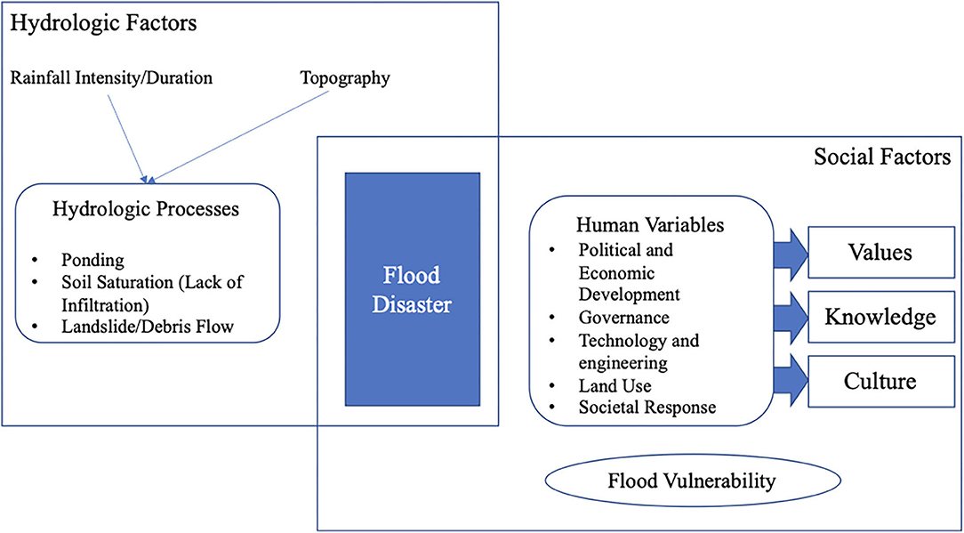
Figure 3. Conceptual model of hydrological and social factors by Carey et al. (2014).
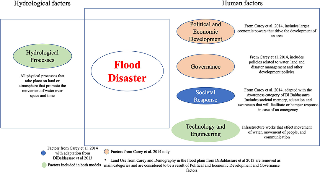
Figure 4. Experimental hybrid model used to study flood hazard and vulnerability in West Virginia.
Di Baldassarre et al. (2013) developed their model to address flooding and compared cases with and without flood protection infrastructure (namely levees), and the effect on social perceptions and policy actions. The model is divided into four categories simplified into single characteristics: technology (levee infrastructure), awareness (societal memory), demography (population growth in floodplain), and hydrology (flood damage). Subsequently, the model describes relations between these categories as directly or inversely proportional, abrupt or coevolving effects, and ultimately discretizes these relations as differential equations through time.
Carey et al. (2014) divided their system into hydrological and social factors and marks the intersection as the interaction between the two. This model was not specifically developed for a flooding event per se but for water resource availability. The hydrological factors in Carey et al. (2014) included several atmospheric and landscape processes that influence land surface water availability. As social factors, the model described human variables which include Political and Economic Development, Governance, Societal Response, Land Use, and Technology and Engineering. These were shaped by values, knowledge, and culture and resulted in water resource demand. The intersection between the hydrological and social factors was the availability of water resource.
From both models we used the concept of hydrological factors, although our conceptualization is more similar to Carey et al. (2014) since the floods in West Virginia were not just a binary issue as conceptualized in Di Baldassarre, but were a mixture of meteorological extremes coupled with physical processes that promoted the movement of water through space and time. For human factors, we primarily followed Carey et al. (2014) with some adaptations from Di Baldassarre et al. (2013) when considering societal response and technology and engineering components. Political and economic development from Carey et al. (2014) was helpful for including larger economic powers that drive development policy in the study area (i.e., extraction economy). Governance, also adapted from Carey et al. (2014), was used to describe policies promulgated by government agencies that related to water, land, and disaster management (or lack thereof). For our study, societal response was mainly realized from Carey et al. (2014) but also included Di Baldassarre et al. (2013) use of societal memory. While from interviews we identified that societal memory was high prior to the June 2016 events, it did very little in terms of community preparedness and response to the floods. Carey et al. (2014) view societal response as a composite of education and disaster awareness. Hence, societal response became an ensemble of response, preparedness, education, and societal memory, which, according to interviewees, all tend to be quite low in the study area. Technology and engineering, included in both models, includes all infrastructure that affect movement of water, movement of people, and communication. According to the interviews, there were myriad water infrastructures with varying levels of effectiveness throughout the communities, though additionally, the disaster itself was exacerbated by failing communication infrastructure such as roads and bridges. Moreover, we included the conceptualization from Di Baldassarre et al. (2013) of decaying infrastructure, which through the interviews was identified as a main factor in exacerbating the hydrological factors.
Understanding the West Virginia 2016 Floods Through an Experimental Approach to Modeling
Based on the factors outlined in the model above, in this section we present the original qualitative data and secondary quantitative findings that allowed for the development of our hybrid model.
Hydrological Factors
Rainelle is located within the Meadow River watershed, while Sulfur Springs is located in the Greenbrier River watershed. Land cover and land use in the county consist primarily of agricultural pasture lands, mixed hard wood forests, and low intensity to high intensity urban areas (Strager, 2011). The population of Lewisburg, the largest city in Greenbrier County, is just shy of 4,000 residents (US Census Bureau, 2018). The land surrounding and upstream of White Sulfur Springs is predominantly agricultural, while the land surrounding and upstream of Rainelle is mixed hardwood forests (Strager, 2012).
Rainelle and White Sulfur Springs are located on the westerly, windward side of the Appalachian Mountains, receiving atmospheric moisture from the Gulf of Mexico, Great Plains, and Appalachian Plateau of the U.S. (Bonnin et al., 2006). Many of the storms over this region are of high intensity and short duration, activating stormflow in flashy headwater streams (Bonnin et al., 2006). Located at elevations upwards of 610 m, the region receives annual rainfall rates between 150 and 203 cm on average (Bonnin et al., 2006). Interviewees asserted that the intensity of the storms quickly saturated the soil letting water flows on the surface. This factor, according to them:
“That's the reason we had so much destruction, because it was moving, that water was not just a flood event where it inundated the properties. It was hit and run and it was going and then everybody else downstream were getting the bulk of that water as well as the debris.” White Sulfur Spring Resident
The topography of both communities are similar, as they are located in steep and narrow valleys surrounded by 152 m high ridges on both sides. Residents confirm this topography:
“Rainelle kind of sits, like, in a bowl, I think. There's mountains all around us and a lot of water come down off the mountains.” Rainelle resident
Due to the steepness of the narrow valleys around these towns and upstream in tributary streams, these creeks carry large loads of sediment and debris resulting from landslides, driftwood and rocks (FEMA, 2016). Ponds resulting from infiltration overflow and soil saturation are also common in small flat patches of land (FEMA, 2016). These topographic characteristics are confirmed by residents' testimonies describing bare slopes prone to erosion which, in such a heavy and prolonged precipitation event, increased the destructiveness of the floods:
“… what happened is a lot of debris came off the hillsides, up in the mountains. All this debris backed up against that culvert and created a natural dam and the water couldn't get through so it just kept backing up into the mountains. All of a sudden that gave way, when it did all this water hit the streams and it couldn't get out of town fast enough.” White Sulfur Spring Resident
Social Factors
Political and Economic Development
Population in Greenbrier County has been stagnant over the past 50 year, hovering around 35,000 residents (US Census Bureau, 2018). Communities impacted by the flood were already in decline due to lack of employment in coal mines, lumber mills, and other industries and due to the opioid epidemic prior to the flood.
Rainelle was founded by John Raine, who started the Meadow River Lumber Company in 1909, one of the largest hardwood lumber mills in the world at the time. The mill closed with the end of the lumber boom in the 1970's and the local community's population and quality of life started to decline. Rainelle has a population of 1,453 with 93.6% identifying as white and the remaining 6.4% being those who identify as persons of color. The median household income is $27,583 and 30.6% of the town lives below the poverty line. Residents indicated the small and declining mill as a potential culprit of the floods:
“There's timber, but it's small timber and it's mostly going to the paper mill. A lot of what happened with this flood, a lot of the debris was hillside stripping. I mean, I'd always heard growing up that for every tree you cut, you got to plant one. You've got to leave so many trees up to hold the hillside. These guys are clearcutting. I mean they're leaving nothing but dirt.” (Rainelle – Authority)
While none of the interviewees could point to an exact cause for the unprecedented destruction of the floods, some believed that the limited vegetation left on the slopes following a century of forest harvesting allowed water to inundate the rivers running through town more quickly than if more trees had been present to retain rainwater. Others attributed the fast inundation to riverbeds clogged with debris and sediment, local topography, or a combination of these factors. Even while the specific environmental factors that caused the extreme flooding events were not uniformly agreed upon, the town already suffered from social and environmental hardships, likely increasing community vulnerability to flooding, which is testified by the lack of stormwater infrastructural maintenance and development, as a frustrated interviewee shared:
“What do you normally think about when you think about infrastructure? When someone says, we're going to build infrastructure. Roads. Plants. The infrastructure we always seem to overlook a lot is civic infrastructure. We need to understand what our civic infrastructure looks like.” (Rainelle Development Authority member)
Hence, when the 2016 floods hit, Rainelle was already economically depressed and had a declining population. At the time of the interviews there were discussions of how the area could imagine a different economic focus in coming years (see also Shinn and Caretta, 2020) with a particular eye on tourism:
“We have some things that are going to be a part of the trail that's coming, we have some other resources to encourage tourists to come in and build on that Appalachian image, not in a bad way, but build on it in a good way. Where people are drawn to be a part of it.” (Rainelle Development Authority member)
White Sulfur Springs is located on the eastern edge of the county and has a total population of 2,745. Demographically, the population is 78% white, with the remaining 22% being people of color. The median household income is $30,441 and 24.1% of the population lives below the poverty line (US Census Bureau, 2018).
While not immune to economic hardship, White Sulfur Springs developed a health spa around its natural springs in the 1770's. Since the 1880's, the community has been buoyed by the presence of the historic Greenbrier Resort, a high-end hotel and world-renowned golf course built on the site of the spring that provides employment to the community. Yet, beyond the resort, the local economy has struggled and the flood was the last straw for some business. So, authorities and residents of White Sulfur Springs, as those of Rainelle, were hoping to:
“Bring back businesses, work with current business owners, building owners and whatever to try to bring back people interested in re-establishing themselves here or maybe even growing here. It's kind of hard to because in the past there's been so many things that have tried and people sometimes don't give it enough time.” – White Sulfur Springs Resident
“We're trying to get more of an outdoor theme to White Sulfur. You know, we have the national forest, we have the parks, state parks, we have the waterways. Use them. Get as much as you can out of them while you're here and promote that to where it's primarily been an antique store here and you got a nice little bakery here and you go the Barnwood Builders right here across the street. You got these things that have put their place here, now let's build on that and what else do we need beyond the bakery, you know beyond the antique store.” White Sulfur Spring Resident
Collectively, these statements articulate that, to decrease vulnerability to future flooding events, these towns need to improve overall economic viability. This can only be done through the ability of residents to participate in local and state governance. However, as described below, there was a general sense of disillusionment with effectiveness of governance responses to the 2016 floods.
Governance
Multiple institutions, agencies, and organizations are involved in floodplain management and flood response in Greenbrier County. According to an employee of White Sulfur Springs City Hall, “Everybody is involved when you're dealing with water.” Flood disaster response involved a complex set of institutions, including federal assistance from FEMA, state-level institutions, and local emergency responders. As discussed below, this complex institutional context does not always work in favor of residents. In general, floodplain management and flood risk reduction efforts are a joint endeavor between the state-level West Virginia Department of Natural Resources (WVDNR) and the West Virginia Conservation Agency (WVCA). Any in-stream work that has the potential to disturb the creek bottom or channel is required to get a permit from the U.S. Army Corps of Engineers, which is often a lengthy process.
In White Sulfur Springs, a flood ordinance from the WV Office of Homeland Security and Disaster Management was put into place in 2012 and prevented any new construction in the floodplain, as testified by this municipal employee:
“The flood plain ordinance was enacted in 2012. Primarily for the National Flood Plain Insurance Program. That was a mandated thing that needed to be in place, and it's something that's always needed to be in place. There was always that risk that could happen.”
While this ordinance allowed residents to have access to flood insurance at lower rates if they did improve their homes, few did that. On the other hand, multiple interviewees mentioned that floodplain maps were redrawn in 2012 and insurance companies no longer required many homeowners to carry flood insurance. This re-zoning made it so that some people whose houses, trailers, businesses were badly damaged in 2016 did not have insurance.
Many of the existing homes in the floodplain were damaged or destroyed by the 2016 floods. In fact, the mayor of White Sulfur Springs estimated that:
“75% were destroyed, that is of the ones that lost their properties. The other 25% were able to be repaired. Of the ones that were destroyed, some of them tore their homes down and rebuilt on the same property. Others decided not to rebuild in that area on that spot and decided to go other places. We here in the city agreed to provide property, Hope Village, to be constructed. With the construction of Hope Village, it provided housing for up to 40 houses.”
Under the ordinance, homes could be rebuilt or repaired only if they stayed within the footprint of the original building. Homes also had to be elevated to meet new guidelines and were required to have flood vents installed and electronics and appliances elevated above flood level. The town also stepped in and, with the help of charity organizations, built a neighborhood from scratch (for more see Shinn and Caretta, 2020).
According to FEMA, ~23% of homes impacted by the June 2016 floods were located outside of the “Special Flood Hazard Area” and, as a result, many did not have flood insurance (Wing et al., 2018). Of those that applied for FEMA's Individual Assistance program, which helps victims of disasters that do not have flood insurance, 68% lived outside of the Special Flood Hazard Area. According to FEMA, people who filed flood insurance claims received an average of $53,500, while those without flood insurance received $8,363 in individual assistance for property repairs (FEMA, 2016). However, as this testimony captures, local residents were disillusioned with the authorities and did not feel that the formal governance responses to flooding disasters assisted many of the people most impacted:
“The only way the federal government stepped in to help with that was because of the fatalities.” White Sulfur Spring resident
As a result of the lack of comprehensive formal response from state and federal institutions, numerous other societal groups took part in recovery efforts. As Shinn and Caretta (2020) have noted, there was a complex societal response to the floods. These included state and federal agencies, residents and local volunteers, regional and national non-governmental organizations (NGOs), and Faith Based Organizations (FBOs) from across the region. In the hours and days immediately following the floods, many roads remained impassable and response came from neighbors and local first responders who often had to deal with damage to their own properties while also helping others. Within a few days, volunteers came from nearby areas and the National Guard and Red Cross arrived. In the following weeks and months, outside volunteer groups and the White Sulfur Springs-based group Neighbors Helping Neighbors (NHN) (funded by members of the Greenbrier Resort) began to help repair and rebuild damaged homes. FEMA played a critical role, but rarely provided enough individual support to help residents fully recover. As a result, West Virginia's Voluntary Organizations Active in Disasters (VOAD) group, supported by a grant from FEMA, began assisting people. VOAD case workers would receive applications for assistance and coordinate with FEMA, NGOs, and FBOs to get people the resources they needed. With these coordinated efforts, hundreds of flood victims in Greenbrier County now live in newly built or fully renovated homes and are safer than they were before the 2016 floods.
Societal Response and Memory
While residents and aid groups made significant strides in recovery efforts, many of those impacted by the floods did not make a full recovery and population losses were directly attributed to the flood in both towns.
According to respondents in Rainelle, the flood drove approximately: “400 residents away due to lack of insurance or resources to recover” and “communities were not able to recover from [the flood].” (Rainelle Authority)
While floods have been a part of life in Greenbrier County for a long time, interviews revealed a lack of societal memory of these events. By exploring societal memories of floods, we can better understand which actions and emotions provided a warning or a coping mechanism against floods (see also McEwen et al., 2016). Many of the communities in the region were affected by destructive floods in 1972 and 1985 as well. However, interviewees could rarely recount the floods that had taken place more than 30 years earlier. Instead, they would say things such as,
“Oh, we've had floods, you know, the creeks have run over their banks… I've been here all my life, I've never seen anything like it and I don't think anybody older than I am has seen it either. But we have seen, you know, high water.” (Rainelle resident)
Some noted on large rain events and smaller floods that had happened in 1972, 1985, 1995, and 2003.
“Now we had a flood in 2003 that got in our garage. And it got 6 inches in our garage. Well back then that's all it was, a garage. And we figured that an event like that would never happen again.” (White Sulfur Spring resident)
This lack of societal memory hampered the work of disaster awareness and negatively affected both the individual and community preparedness and response to such a disaster. This also seems to be reflected in that fact that most interviewees appeared to think that the 2016 floods were a once-in-a-lifetime event that would not repeat itself. Authorities were trying to counteract that rhetoric:
“We're trying that, it's hard to get people to change. This is a town of old thoughts and old ways, the. ‘if it didn't happen in my lifetime, it'll never happen again' kind of attitude. But last year proved a lot of those people wrong as well as opened their eyes.” (White Sulfur Spring authority)
Such statements appear to be corroborated by some interviewees who said they were now willing to participate in a warning network and disaster preparedness exercises. When Caretta and Shinn carried out semi-structured interviews in the spring and summer of 2017, many of the interviewees had never recounted their experience of the June 2016 floods with another person. Many of the respondents were distressed and, although we made it clear that they should not continue in their account if they did not want to, shared while in tears how the water had risen and how they had escaped their homes. Many immediately began to help their neighbors to get out of their homes. While first responders had focused on the material and practical aspects of flood recovery, the emotional component of losing relatives, neighbors, homes, and property was overlooked. The lack of attention to mental health and societal memory is problematic and increased services in this area would likely reduce vulnerability in the future.
Technology and Infrastructure
Organizations, residents and authorities agreed that the lack of adequate storm water infrastructure greatly exacerbated the flood in White Sulfur Springs and Rainelle. Several interviewees stated that the storm drains in both communities were antiquated, undersized, and under maintained.
“There's low areas along the creek, there's low areas because the way the storms drains in town are antiquated, they haven't kept up with the development in some areas. When you have low areas and you put streets, you sort of compartmentalize that water and it has nowhere to go.” (White Sulfur Spring resident)
Additionally, most of the drainage infrastructure was clogged with sediment and accumulated debris, as reported by this Rainelle resident: “a drainage culvert backed up. And it's the main culvert into Rainelle, when it hits that stream, this stream here and the other stream there drain into the Meadow River and they couldn't get out fast enough.”
To prevent such disaster from happening, riverbanks around White Sulfur Springs had been dredged in order to withstand large scale floods. Interviewees stated that during the 1980's, the banks of Wades Creek were anchored and structured with rocks. However, these works were made by the U.S. Army Corps of Engineers and the city had no jurisdiction to update these protective measures.
“Back in 1960, they dredged up the creek. Before then they had a lot of flooding. It was not unusual to see water in the main street. And since that time, it happened in 2003, 2002.” (White Sulfur Spring resident)
It is possible that the design of the channel alone would not have been able to withstand the 2016 flood waters, and the lack of maintenance only increased the damage done by the floods. At the same time, infrastructure such as the Tuckahoe Dam upstream of White Sulfur Springs held storm water, effectively reducing flood inundation downstream, as this interviewee shared:
“Because we had a flood control project done here, years ago, the Tuckahoe Dam and the creeks dredged out and so everybody got a mindset like well White Sulfur doesn't flood anymore.” (White Sulfur Spring Organization Member)
Other types of infrastructure, including roads and service (electric, water, and gas), and a national fish hatchery, were also severely damaged. Transportation infrastructures collapsed or were left unstable, which slowed evacuation and prevented emergency services from immediately responding to some victims and clearing debris. Some residents reported that several bridges had been previously raised, increasing channel size below the bridge, thus reducing blockage and subsequently flood damage. However, not all changes made had been sufficient, as this interviewee reported:
“Once that debris hit that bridge, it started creating this sweep underneath of it and coming around it and going down through these places. With the preventive measures that we're hopefully taking today that will lessen that debris floating away. “(White Sulfur Spring Organization Authority)
As this statement highlights, these two communities were counting on preventive measures put in place at the time of interviews to advert such a disaster from happening again. However, an early mobile phone warning system that was in place in 2016, and that is often presented as a technological “silver bullet” in flood preparedness, was ignored by residents:
“And so flash flood warnings pop up and you just kind of blow it off, so nobody is going to blow it off anymore. Because not in a million years, not in a million years would anyone have seen that coming.” (White Sulfur Spring Organization Member)
Collectively, we find that while there is a complex flood response governance structure, lack of adequate flood recovery support for many residents, limited societal memory, skepticism that such a disaster would occur again and lack of trust in major existing infrastructure (i.e. dam and the frequency of floods) present barriers for its implementation. These factors contribute to lessened residents' preparedness and hence vulnerability to future flooding events. It is these kinds of multi-factor relations that we try to unravel in the following section.
Toward an Interdisciplinary Understanding of Flood Hazard and Vulnerability
Based on the data presented above, and the model that we developed (Figure 4), we identify relationships between categories within social and physical factors. Following Carey et al. (2014, p. 66), we strived to address “cultural shift across the water related disciplines— not simply, and hegemonically, folding the social sciences into hydrology, but rather through systematic efforts …to collaborate and find new ways of making [our] data intersect.” We depart from the interviewee data and the biophysical factors presented in the previous section to develop a model that could show the relations between them and be used in other studies of flood hazard and vulnerability. Our attempt to show how our data intersects is presented in Figure 4, where we outline a model that would allow us to explore flood vulnerability in West Virginia. The potential incompleteness and partiality of this model embodies months of epistemological discussions in which Caretta and Shinn, as human geographers, wrestled with the idea of “putting people in a box,” and Fernandez and Zegre tried to account in a schematic way for all the interrelations and feedbacks between different factors.
Carey et al. (2014) and Di Baldassarre et al. (2013) similarly conceptualize these variables (Figures 2, 3). The HS model clearly separates physical hydrology from anthropogenic dynamics. The SH model, despite organizing the data in a seemingly endogenous way, still conveys a division between hydrological and social factors. Both models share categories (i.e., technology) and have adaptive factors (Societal Memory from the SH model fits onto the Societal Response of HS model). The HS model includes larger scale categories such as Political Development and Governance.
These two approaches provided complementary roadmaps that we used to map out factors leading to the WV floods. It quickly became apparent that both models did not reflect the entirety of the issues at hand, but had strengths that were beneficial for understanding the social-water configuration of the flood to conceptually map what we learned from the interviews. While the categories provided by Di Baldassarre et al. (2013) were reduced to single factors and represented as model parameters, the relationships between categories were useful. Because various storm infrastructures are at play in our system (i.e., blocked culverts, drainage ditches, a dam, and a reservoir), we were not able to simplify “technology” to a single flood protection infrastructure measure. In similar fashion, we could not simplify societal memory using a decay function of flood occurrence like Di Baldassarre et al. (2013) because, given complex topography and intermittent stream networks, communities experienced different flood magnitudes at different recurrences.
Within our conceptualization (Figure 5), we set forth that while social and hydrological factors can be presented as purely geophysical or anthropogenic, their intersection is the crux to be investigated. The relationships within variables of both major categories can in fact help us understand how the social and biophysical systems are interrelated. We used qualitative data from the interviews to derive relations between different factors among the categories and understand the path to vulnerability and hazard enhancement from a physical and social perspective.
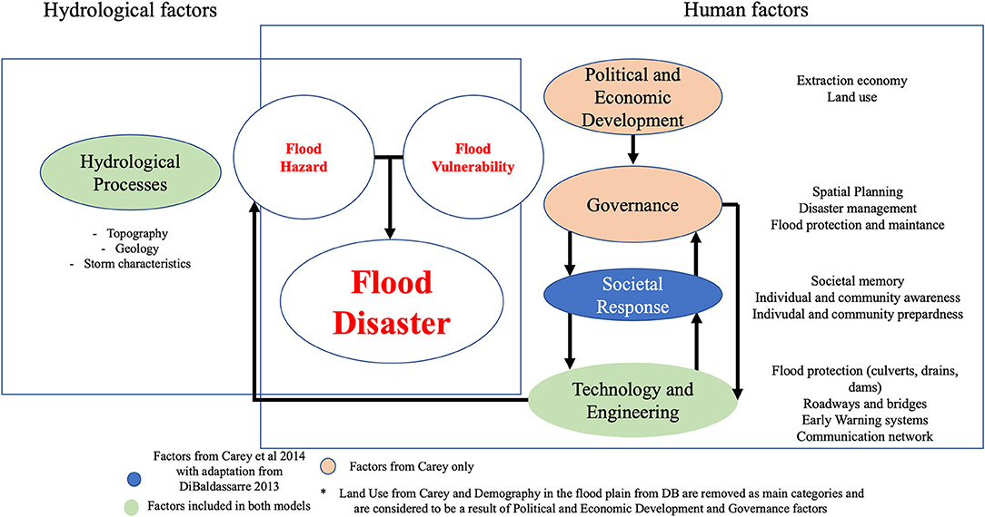
Figure 5. Experimental hybrid model used to study flood hazard and vulnerability in West Virginia showing relations between social and biophysical factors.
This model can represent the factors and conditions that progressively increased the flood hazard (natural and societal) and vulnerability of communities in White Sulfur Springs and Rainelle leading up to the 2016 flood disaster.
We identify five main categories included in Figure 4 (i.e., hydrological processes, political and economic development, governance, societal response, technology and infrastructure). As seen in Figure 5, the poor and declining level of economic development of West Virginia as a whole, and in Greenbrier County specifically, negatively affected governance. A critical element of effective governance is strong institutions that set and enforce policies to protect communities from floods (Driessen et al., 2016). Arguably, institutions in West Virginia tasked with managing water resources and minimizing flood risks to citizens are weak due to polices that prioritize resource extraction-based political agenda (Bell and York, 2010). These priorities are demonstrated in two clear ways. First, rural roads were designed, built and maintained primarily to transport coal, gas, and timber and are often just wide enough for one vehicle, yet are narrow, steep, and prone to landslides and overflowing waterways. Maintenance typically conducted by state institutions (e.g., Dept. of Highways) includes paving, but roads are rarely widened, and culverts and roadside ditches are seldom cleaned or protected from debris. Second, while a WV Flood Protection Task Force led by the West Virginia Conservation Agency (WVCA) developed the West Virginia Statewide Protection Plan, little-to-no action has been taken. Strong institutions necessary to coordinate and develop community information through local floods and hazard maps, evacuation routes, and safe zones are absent. Hence, disaster preparedness stymied by weak institutional governance results in high hazards leading to greater vulnerability. These factors identified from stakeholder interviews and supplemented literature drive the development of our conceptual model in the form of a flux diagram where the state of a preceding variable determines the state(s) of a succeeding variable. For instance, lack of societal memory negatively affected disaster awareness. Because of the low institutional governance and state response networks, faith-based and other NGOs filled the void of disaster response need (Shinn and Caretta, 2020).
Inter-category relations were also identified, such as the economic development leading to low governance previously described. Notably, other relations such as positive infrastructure (e.g., dams, culverts) that are hampered by poor governance and the lack of flood protection enforcement leading to inadequate maintenance, exacerbated flood hazard and increase community vulnerability. Factors from the social component of the model interact to ultimately reduce flood hazards, in the case of dams, or enhance the hazard, in the case of clogged culverts and drainages.
Societal Response in our model is conceptualized as factors that enable the general population to be prepared for and respond to a flood hazard. This is an ensemble of response, preparedness, education, and societal memory, which, according to interviewees, all tend to be quite low in the study area. As an example, communities experienced water inundation on road and bridges due to overflowing culverts and damage from flood debris and sediment. Interviewees acknowledged that even though storms are frequent, and damages are inconvenient, they are used to a certain level of hazard. Despite knowledge of past destructive floods, residents largely do not expect future floods to happen again. Even after the 2016 floods, the prevalent sense was that a 100-year flood is unlikely to happen again in their lifetime.
Technological factors are considered control factors against floods that are enhanced through good governance after a disaster takes place. However, technology is designed to control floods up to a certain magnitude, and, once exceeded, can magnify effects (e.g., Di Baldassarre et al., 2013). In White Sulfur Springs and Rainelle, hydrological factors overwhelmed the existing technological preparedness of the communities. However, the flood was not so disastrous as to compromise the Tuckahoe Dam. While technology effectively failed in the town, the dam upstream had the effect of decreasing awareness and societal memory by providing a false sense of security, possibly reducing societal response prior to the disaster (Di Baldassarre et al., 2013). Further, inadequate early warning systems can hamper societal response as people wait for warning instead of evacuating early (Alcántara-Ayala and Oliver-Smith, 2019). Several interviewees remarked that the general population should not wait for alerts and evacuate when they see rising water. This indicates lack of reliability on technology and warning systems, further decreasing levels of preparedness to respond to future floods.
Linton and Budds (2014) contend that the way institutions organize around flood events and subsequently build adequate flood protection infrastructure is an important process in which water and society intersect and shape each other. Institutions later restructure themselves by adapting their functionality to the changing landscape, environment, and climate. In our case study, this process of evolution is still ongoing. The lived experiences of citizens and responders demonstrate that this was in part a manmade disaster due to clear cutting, consequential heavy rainfall overwhelmed storm water and flood protection infrastructure, and the poor conditions of roads hampered rescue efforts. This increased local vulnerability and the potential destructiveness of abrupt flood events, both of which are expected to increase due to climate change (Wing et al., 2018).
There are three main impacts directly stemming from the flood: societal impacts in the form of fatalities, injury, personal property and mental health; negative impacts to economic development; and immediate increase in societal memory. The loss of lives, the widespread damage and the negative economic impacts triggered FEMA to immediately assess causes and impacts of the flood (2016), and led to technical interventions to respond to future floods to reduce the eventuality of their return. By the same token, the recently enhanced societal memory led to an increase in community disaster awareness, additional participation in developing disaster management policies, and community and economic development (Shinn and Caretta, 2020). Although these processes might reduce vulnerability, they may be short lived, as Di Baldassarre et al. (2013) identifies societal memory as a factor that declines with time as recovery brings back daily routines and the economy. Additionally, our analysis identifies lack of societal memory and weak institutions as a root cause of regional flood vulnerability. Flood protection enforcement and disaster awareness and management are long term processes which rely on strong institutional knowledge and engagement with community members.
Other case studies will present a different combination of positive and negative relationships. Linking these factors is crucial step toward integration of SH and HS approaches to create a more comprehensive understanding of water-human relations. Such studies can inform policymakers by highlighting where negative connections can be remedied and positive connections can be fostered to improve water justice.
Zwarteveen and Boelens (2014) argue that water justice must be understood as contextual, with attention to how it is at once material and economic, as well as cultural and political. As a result, water justice necessitates contestation and negotiation both in direct relation to management of water resources, and to the norms and laws that govern that management (Zwarteveen and Boelens, 2014). In the context of flooding, water justice is about who has the power to determine how potential for flooding is mitigated and how flooding events are responded to when they do happen. Our model of Greenbrier County, WV, shows that water justice in this context would involve increasing public participation in local mitigation and response efforts, as well as reducing overall socio-economic vulnerability so that people are better equipped to respond to future disasters.
Conclusion
This paper is a testimony to the fact that interdisciplinary research is not easy, it is a struggle, but it is also a rewarding and enriching intellectual endeavor. We add to the limited examples of scientists working across epistemologies to improve the understanding of water-societal relations (e.g., Landström et al., 2011; Ferdous et al., 2018). In so doing, we also contribute to broader discussions of water justice.
We approached this work from an experimental angle, the development of a model derived from contextual data but aimed at better linking the different factors leading to and deriving from flood disasters. We encourage sociohydrologists and hydrosociologists to build on this model and to work toward a shared model that can guide collective data gathering and analysis. Using this model as a compass post data-gathering, we argue, can be beneficial for synthetizing hydrological and social factors that are not exogenous to one another but are clearly linked. Explicitly unraveling these linkages is crucial for two reasons. First, our model is a preliminary attempt to more comprehensibly study the relationships between society and flooding and provides a framework to understand relations between social and biophysical variables. Second, by understanding the relations among flooding factors, policies and actions can address negative feedbacks by turning them into positive development priorities. By connecting physical and social factors and presenting them in a way they can be geared toward policy recommendations, the approach presented in this paper offers a potential pathway toward enhancing the understanding of vulnerability to flooding in an interdisciplinary way.
This model is the result of a shared process of knowledge construction stemmed from an interest in attaining a more comprehensive understanding of floods hazard and vulnerability. We were aware that, given the complexity of studying flood hazard vulnerability in a way that integrates human-environment interactions, neither of our human geography nor hydrology toolboxes were sufficient. While HS provides in-depth explanations of social relations that are likely to be missed by use of SH, HS does not create generalizable insights that can be modeled or otherwise used to understand relations at other locations or scales (Wesselink et al., 2017). While SH is grounded on robust understanding of physical components that can be scaled up to the global level, it does not account for feedbacks between complex human processes and fast physical processes. SH models strive to incorporate social aspects such as societal memory and infrastructure. However, flood disasters, namely the enhancement of flood hazards and increase of flood vulnerability, are the result of complex networks of processes rooted in political, economic and cultural conditions. In short, both approaches are incomplete and sub-optimal. Hence, we respond to and we extend the call to carry out interdisciplinary work for the advancement of scientific understanding related to water justice.
We were aware of our ontological and epistemological differences, but we were guided by the common goal of informing citizens and, potentially, policy makers. Given fieldwork, a professional career in the state university and our situatedness in the place where the 2016 tragedy took place, we understood the need to improve the public and policy understanding around floods. These climate extremes are becoming increasingly more common and destructive in West Virginia. We argue that such shared entry point was fundamental for the four of us to work through our different disciplinary understandings of the causes, manifestations of and potential solutions to flood vulnerability and hazard. Thus, we call on our “water colleagues,” whether hydrosociologists or sociohydrologists, to look beyond their ontological and epistemological notions and appreciate that, while holism cannot be reached, interdisciplinary collaboration can enrich wider societal knowledge and understandings of water justice.
Data Availability Statement
The raw data supporting the conclusions of this article will be made available by the authors, without undue reservation.
Ethics Statement
The studies involving human participants were reviewed and approved by West Virginia University IRB. The patients/participants provided their written informed consent to participate in this study.
Author Contributions
All authors listed have made a substantial, direct and intellectual contribution to the work, and approved it for publication.
Funding
This research was funded, in part, by the National Science Foundation grant number OIA-148952 and the USDA National Institute of Food and Agriculture Hatch project (Grant Number: 1004360).
Conflict of Interest
The authors declare that the research was conducted in the absence of any commercial or financial relationships that could be construed as a potential conflict of interest.
Acknowledgments
Thanks to Brandon Rothrock and Rachael Hood for the support provided for language proofing and formatting the manuscript. The authors would also like thank all of their research participants in Greenbrier County, as well as the reviewers for providing helpful feedback.
References
Alcántara-Ayala, I., and Oliver-Smith, A. (2019). Early warning systems: lost in translation or late by definition? A FORIN approach. Int. J. Disast. Risk Sci. 10, 317–331. doi: 10.1007/s13753-019-00231-3
Austin, S. H., Watson, K. M., Lotspeich, R. R., Cauller, S. J., White, J. S., and Wicklein, S. M. (2018). Characteristics of Peak Streamflows and Extent of Inundation in Areas of West Virginia and Southwestern Virginia Affected by Flooding, June 2016 (No. 2017-1140). US Geological Survey. doi: 10.3133/ofr20171140
Beck, E., and Kersey, L. (2016). At Least 22 Confirmed Dead in Massive WV Flooding. Charleston Gazette-Mail. Available online at: https://www.wvgazettemail.com/news/at-least-22-confirmed-dead-in-massive-wv-flooding/article_b0a3a2f6-82e3-55eb-98f2-8b6c8d2d0b55.html (accessed June 8, 2021).
Bell, S. E., and York, R. (2010). Community economic identity: the coal industry and ideology construction in West Virginia. Rural Sociol. 75, 111–143. doi: 10.1111/j.1549-0831.2009.00004.x
Blöschl, G., Bierkens, M. F., Chambel, A., Cudennec, C., Destouni, G., Fiori, A., et al. (2019). Twenty-three unsolved problems in hydrology (UPH)–a community perspective. Hydrol. Sci. J. 64, 1141–1158. doi: 10.1080/02626667.2019.1620507
Boelens, R., Hoogesteger, J., Swyngedouw, E., Vos, J., and Wester, P. (2016). Hydrosocial territories: a political ecology perspective. Water Int. 41, 1–14. doi: 10.1080/02508060.2016.1134898
Bonnin, G. M., Martin, D., Lin, B., Parzybok, T., Yekta, M., and Riley, M. (2006). Precipitation-Frequency Atlas of the United States Volume 2. Version 3.0. Silver Spring, MD: National Oceanic and Atmospheric Administration, 295.
Budds, J. (2008). Whose scarcity? The hydrosocial cycle and the changing waterscape of La Ligua river basin, Chile. Contentious Geogr. Environ. Mean. Scale 59–68.
Budds, J., and Hinojosa-Valencia, L. (2012). Restructuring and rescaling water governance in mining contexts: the co-production of waterscapes in Peru. Water Alternativ. 5, 119–137. Available online at: http://oro.open.ac.uk/32484/
Carey, M., Baraer, M., Mark, B. G., French, A., Bury, J., Young, K. R., et al. (2014). Toward hydro-social modeling: merging human variables and the social sciences with climate-glacier runoff models (Santa River, Peru). J. Hydrol. 518, 60–70. doi: 10.1016/j.jhydrol.2013.11.006
Cook, J. (2019). Greenbrier County Floods: Confronting Climate Change in Trump's Coal Country. BBC. Available online at: https://www.bbc.com/news/world-us-canada-49802038 (accessed June 8, 2021).
Di Baldassarre, G., Sivapalan, M., Rusca, M., Cudennec, C., Garcia, M., Kreibich, H., et al. (2019). Sociohydrology: Scientific challenges in addressing the sustainable development goals. Water Resour. Res. 55, 6327–6355. doi: 10.1029/2018WR023901
Di Baldassarre, G., Viglione, A., Carr, G., Kuil, K., Salinas, J. L., and Blöschl, G. (2013). Socio-hydrology: conceptualising human-flood interactions. Hydrol. Earth Syst. Sci. 17, 3295–3303. doi: 10.5194/hess-17-3295-2013
Di Baldassarre, G., Viglione, A., Carr, G., Kuil, L., Yan, K., Brandimarte, L., et al. (2015). Debates—perspectives on socio-hydrology: capturing feedbacks between physical and social processes. Water Resour. Res. 51, 4770–4781. doi: 10.1002/2014WR016416
Di Liberto, T. (2016). Thousand-Year' Downpour Led to Deadly West Virginia Floods. National Oceanic and Atmospheric Administration. Avaialble online at: https://www.climate.gov/news-features/event-tracker/thousand-year-downpour-led-deadly-west-virginia-floods (accessed June 8, 2021).
Driessen, P. P., Hegger, D. L., Bakker, M. H., van Rijswick, H. F., and Kundzewicz, Z. W. (2016). Toward more resilient flood risk governance. Ecol. Soc. 21:453. doi: 10.5751/ES-08921-210453
Ehlke, T. A., Runner, G. S., and Downs, S. C. (1982). Hydrology of Area 9, Eastern Coal Province, West Virginia, Vol. 81. Elche: US Department of the Interior, Geological Survey; Charleston. doi: 10.3133/ofr81803
FEMA (2016). Understanding Flood Dangers in Central West Virginia: Lessons Learned from the June 2016 Flood. Available online at: https://www.fema.gov/sites/default/files/documents/Region_III_WV_FloodReport.pdf (accessed June 8, 2021).
Ferdous, M. R., Wesselink, A., Brandimarte, L., Slager, K., Zwarteveen, M., and Baldassarre, G. D. (2018). Socio-hydrological spaces in the Jamuna River floodplain in Bangladesh. Hydrol. Earth Syst. Sci. 22, 5159–5173. doi: 10.5194/hess-22-5159-2018
Gober, P., and Wheater, H. S. (2014). Socio-hydrology and the science–policy interface: a case study of the Saskatchewan River basin. Hydrol. Earth Syst. Sci. 18, 1413–1422. doi: 10.5194/hess-18-1413-2014
Hettiarachchi, S., Wasko, C., and Sharma, A. (2018). Increase in flood risk resulting from climate change in a developed urban watershed–the role of storm temporal patterns. Hydrol. Earth Syst. Sci. 22, 2041–2056. doi: 10.5194/hess-22-2041-2018
Hu, P., Zhang, Q., Shi, P., Chen, B., and Fang, J. (2018). Flood-induced mortality across the globe: spatiotemporal pattern and influencing factors. Sci. Total Environ. 643, 171–182. doi: 10.1016/j.scitotenv.2018.06.197
Khajehei, S., Ahmadalipour, A., Shao, W., and Moradkhani, H. (2020). A place-based assessment of flash flood hazard and vulnerability in the contiguous United States. Sci. Rep. 10, 1–12. doi: 10.1038/s41598-019-57349-z
Landström, C., Whatmore, S. J., Lane, S. N., Odoni, N. A., Ward, N., and Bradley, S. (2011). Coproducing flood risk knowledge: redistributing expertise in critical “participatory modelling.” Environ. Plan. A 43, 1617–1633. doi: 10.1068/a43482
Lane, S. N. (2014). Acting, predicting and intervening in a socio-hydrological world. Hydrol. Earth Syst. Sci. 18, 927–952. doi: 10.5194/hess-18-927-2014
Lave, R., Wilson, M. W., Barron, E. S., Biermann, C., Carey, M. A., Duvall, C. S., et al. (2014). Intervention: critical physical geography. Can. Geographer. 58, 1–10. doi: 10.1111/cag.12061
Leavy, P., and Saldana, J. (2014). Coding and Analysis Strategies. The Oxford Handbook of Qualitative Research. Oxford: Oxford University Press. doi: 10.1093/oxfordhb/9780199811755.013.001
Lindersson, S., Brandimarte, L., Mård, J., and Di Baldassarre, G. (2020). A review of freely accessible global datasets for the study of floods, droughts and their interactions with human societies. Wiley Interdiscipl. Rev. Water 7:e1424. doi: 10.1002/wat2.1424
Linton, J. (2008). Is the hydrologic cycle sustainable? A historical–geographical critique of a modern concept. Ann. Assoc. Am. Geographer. 98, 630–649. doi: 10.1080/00045600802046619
Linton, J. (2012). The Human Right to What? Water, Rights, Humans, and the Relation of Things. The Right to Water: Politics, Governance and Social Struggles. New York, NY: Earthscan, 45–60.
Linton, J., and Budds, J. (2014). The hydrosocial cycle: defining and mobilizing a relational-dialectical approach to water. Geoforum 57, 170–180. doi: 10.1016/j.geoforum.2013.10.008
Liu, Y., Tian, F., Hu, H., and Sivapalan, M. (2014). Socio-hydrologic perspectives of the co-evolution of humans and water in the Tarim River basin, Western China: the Taiji–Tire model. Hydrol. Earth Syst. Sci. 18, 1289–1303. doi: 10.5194/hess-18-1289-2014
McEwen, L., Garde-Hansen, J., Holmes, A., Jones, O., and Krause, F. (2016). Sustainable flood memories, lay knowledges and the development of community resilience to future flood risk. Trans. Inst. Br. Geogr. 42, 14–28. doi: 10.1051/e3sconf/20160709002
MetroNews West Virginia (2016). Burning house floats down Howard's Creek in White Sulphur Springs June 23, 2016. Available online at: https://www.wsaz.com/content/news/Burning-house-floats-down-creek-in-White-Sulphur-Springs-384207501.html (accessed March 30, 2021).
NOAA National Centers for Environmental Information (2021). U.S. Billion-Dollar Weather and Climate Disasters. Available online at: https://www.ncdc.noaa.gov/billions/ (accessed June 8, 2021).
NOAA National Weather Service (2016). Record Flooding. Available online at: http://www.weather.gov/lix/August2016flood (accessed March 30, 2021).
Pande, S., and Sivapalan, M. (2017). Progress in socio-hydrology: a meta-analysis of challenges and opportunities. Wiley Interdiscipl. Rev. Water 4:e1193. doi: 10.1002/wat2.1193
Papalexiou, S. M., and Montanari, A. (2019). Global and regional increase of precipitation extremes under global warming. Water Resour. Res. 55, 4901–4914. doi: 10.1029/2018WR024067
Pytalski, P. (2018). Water in Appalachia Needs a Trillion Dollar Solution. West Virginia Public Broadcasting. Available online at: https://www.wvpublic.org/news/2018-07-09/water-in-appalachia-needs-a-trillion-dollar-solutionx (accessed June 8, 2021).
Ray, K., Giri, R. K., Ray, S. S., Dimri, A. P., and Rajeevan, M. (2021). An assessment of long-term changes in mortalities due to extreme weather events in India: a study of 50 years' data, 1970–2019. Weather Clim. Extr. 32:100315. doi: 10.1016/j.wace.2021.100315
Ross, A., and Chang, H. (2020). Socio-hydrology with hydrosocial theory: two sides of the same coin? Hydrol. Sci. J. 2020, 1–15. doi: 10.1080/02626667.2020.1761023
Rufat, S., Tate, E., Burton, C. G., and Maroof, A. S. (2015). Social vulnerability to floods: review of case studies and implications for measurement. Int. J. Disast. Risk Reduct. 14, 470–486. doi: 10.1016/j.ijdrr.2015.09.013
Savenije, H. H., and Van der Zaag, P. (2008). Integrated water resources management: concepts and issues. Phys. Chem. Earth A/B/C 33, 290–297. doi: 10.1016/j.pce.2008.02.003
Seidl, R., and Barthel, R. (2017). Linking scientific disciplines: hydrology and social sciences. J. Hydrol. 550, 441–452. doi: 10.1016/j.jhydrol.2017.05.008
Shinn, J. E. (2016). Adaptive environmental governance of changing social-ecological systems: empirical insights from the Okavango Delta, Botswana. Glob. Environ. Change 40, 50–59. doi: 10.1016/j.gloenvcha.2016.06.011
Shinn, J. E., and Caretta, M. A. (2020). “If it wasn't for the faith-based groups, we wouldn't be where we are today”: flooding response and recovery in Greenbrier County, WV. Southeastern Geographer. 60, 235–253. doi: 10.1353/sgo.2020.0019
Sivapalan, M., Savenije, H. H., and Blöschl, G. (2012). Socio-hydrology: a new science of people and water. Hydrol. Process 26, 1270–1276. doi: 10.1002/hyp.8426
Strager, M. (2011). Data From: Land Use/Land Cover of West Virginia. West Virginia GIS Technical Center. Available online at: http://wvgis.wvu.edu/data/dataset.php?ID=451 (accessed June 8, 2021).
Strager, M. (2012). Data From: Land Use/Land cover of West Virginia. West Virginia GIS and Technical Center. Available online at: http://wvgis.wvu.edu/data/dataset.php?ID=451 (accessed June 8, 2021).
Swyngedouw, E. (1999). Modernity and hybridity: nature, regeneracionismo, and the production of the Spanish waterscape, 1890–1930. Ann. Assoc. Am. Geographer. 89, 443–465. doi: 10.1111/0004-5608.00157
Tellman, B., Schank, C., Schwarz, B., Howe, P. D., and de Sherbinin, A. (2020). Using disaster outcomes to validate components of social vulnerability to floods: flood deaths and property damage across the USA. Sustainability 12:6006 doi: 10.3390/su12156006
United States Geological Survey (1988). National Water Summary 1988-89- Floods and Droughts: West Virginia. (USGS Water Supply Paper 2375). Washington, DC: U.S. Government Printing Office.
US Census Bureau (2018). American Community Survey 5-Year Estimates. Retrieved from Census Reporter Profile page of White Sulfur Springs, WV. Available online at: https://censusreporter.org/profiles/16000US5486812-white-sulphur-springs-wv/ (accessed June 8, 2021).
US Geological Survey (2021). National Water Information System—Web Interface. Washington, DC: US Geological Survey.
Wasko, C., and Sharma, A. (2017). Global assessment of flood and storm extremes with increased temperatures. Sci. Rep. 7, 1–8. doi: 10.1038/s41598-017-08481-1
Watson, K. M., and Cauller, S. J. (2017). Flood Inundation, Flood Depth, and High-Water Marks for Selected Areas in West Virginia from the June 2016 Flood: U.S. Geological Survey Data Release. Available online at: https://doi.org/10.5066/F76T0K4K (accessed March 30, 2021).
Wesselink, A., Kooy, M., and Warner, J. (2017). Socio-hydrology and hydrosocial analysis: toward dialogues across disciplines. Wiley Interdiscipl. Rev. Water 4:e1196. doi: 10.1002/wat2.1196
West Virginia University Eberly College of Arts Sciences (2020). Finding Renewal in the Aftermath of Floods. Newswise Available online at: https://www.newswise.com/articles/finding-renewal-in-the-aftermath-of-floods (accessed June 8, 2021).
Wing, O. E., Bates, P. D., Smith, A. M., Sampson, C. C., Johnson, K. A., Fargione, J., et al. (2018). Estimates of present and future flood risk in the conterminous United States. Environ. Res. Lett. 13:034023. doi: 10.1088/1748-9326/aaac65
Zégre, N. P., Maxwell, A., and Lamont, S. (2013). Characterizing streamflow response of a mountaintop-mined watershed to changing land use. Appl. Geogr. 39, 5–15. doi: 10.1016/j.apgeog.2012.11.008
Keywords: sociohydrology, hydrosocial cycle, floods, Appalachia, vulnerability, hazard
Citation: Caretta MA, Fernandez R, Zegre N and Shinn J (2021) Flooding Hazard and Vulnerability. An Interdisciplinary Experimental Approach for the Study of the 2016 West Virginia Floods. Front. Water 3:656417. doi: 10.3389/frwa.2021.656417
Received: 20 January 2021; Accepted: 25 May 2021;
Published: 01 July 2021.
Edited by:
Melissa Haeffner, Portland State University, United StatesReviewed by:
Margreet Zwarteveen, IHE Delft Institute for Water Education, NetherlandsTimos Karpouzoglou, Royal Institute of Technology, Sweden
Copyright © 2021 Caretta, Fernandez, Zegre and Shinn. This is an open-access article distributed under the terms of the Creative Commons Attribution License (CC BY). The use, distribution or reproduction in other forums is permitted, provided the original author(s) and the copyright owner(s) are credited and that the original publication in this journal is cited, in accordance with accepted academic practice. No use, distribution or reproduction is permitted which does not comply with these terms.
*Correspondence: Martina Angela Caretta, bWFydGluYV9hbmdlbGEuY2FyZXR0YUBrZWcubHUuc2U=
†These authors have contributed equally to this work and share first authorship
‡These authors have contributed equally to this work and share senior authorship