 Mojdeh Rakhshan
 Hossein Mahmoudi
 Asghar Abdoli
 Hadi Veisi1
- 1Environmental Sciences Research Institute, Shahid Beheshti University, Tehran, Iran
- 2Natural Resources and Marine Sciences Institute, Tarbiat Modares University, Tehran, Iran
According to the importance of Locals impact on conservation, this research had tried to find the role of locals in the protection of natural resources and ecosystems, and also tried to clarify the external laws which are affecting on local's livelihood. This research had done in Ab-e Ask village which is located on the edge of the Lar National Park and along the Haraz River, which is one of the five protected rivers in Iran, and it used the public participatory methods. Using the “Problem Tree,” “Before and After Diagram,” “Social Resources Map,” and etc., helped us to find the answers of: 1. The main reasons of water pollution 2. The land ownership‘s effect on livelihood 3. Finding the traditional approaches of conservation. Finally, the results were about: 1. The sewage of Haraz Road Restaurants and also the pollution of fish ponds were the main water pollution reasons. 2. The effect of Land Ownership Law was clarified and 3. There were two Local Traditions that protect the natural resources, one was called “Barf-e-Chal” which was about saving the water sources for the summer, and the other was about protecting the plants of region until the end of pollination season that results in protecting the flora.
Introduction
Public participation has been recognized as the missing element of development, management, and protection projects using the term sustainable development at the Rio Conference in 1992, following the successive failures of development programs and projects by researchers. Policies still face many failures although European countries shared their experiences during these years for the better use and management of natural resources. Thus, the question arises is related to the way people and different social, economic, and cultural aspects affect resource protection (Dang, 2020). Thus, international organizations introduced public participation as a key element in development projects and programs (Rudqvist and Woodford-Berger, 1996). In fact, public participation means allowing people to affect the output of government-designed processes and programs (Poppe et al., 2018). In recent years, wildlife policies that consider the participation of stakeholders have been promoted. An understanding of the stakeholders' attitudes toward conservation and existing policies are critical in designing new policies or sustainable conservation strategies (Weladji et al., 2003). In this regard, involving the participation of local peoples in each region, using their knowledge, and evaluating the examples of protection, interact or conflict which occur according to the beliefs and knowledge of local peoples in the region can pave the way for many protection and development projects (Brook and McLachlan, 2008). In other words, protecting the resources of which local peoples considered as beneficiaries will be more effective with the help of people: “using interviews have failed, along with the opinion of indigenous peoples. Thus, the opinion of local people with the activities entrusted to them should be added to protection projects to maximize the use of knowledge to its maximum efficiency” (Brook and McLachlan, 2008).
Due to the experience of researchers during the recent decades and after the great effect that the PRA (Public Participatory Appraisal) method had on Indian and Kenyan societies in 1990, using this method has become a principle at many universities dealing with development concepts (Cornwall and Pratt, 2011). Rapid Rural Analyze and Rural Participatory Analyze are among the most popular and widely used methods used by societies to implement their conservation and management goals. Although these methods have many similarities, but there are also some differences in their conceptual principles as follows.
- In rural evaluation, the knowledge of local people is emphasized while the villagers are the collectors of data and, the main analysis and processing are performed by external experts (Chambers, 1993).
- Rural participatory evaluation is a centralized method for indicating the local capacities of societies to solve existing problems and is considered as an approach for the silent voices of some classes of society who have been marginalized for different reasons (Hossein Bar and Rustakhiz, 2017). In participatory evaluation, while emphasizing indigenous knowledge, the analysis and processing of data are conducted by applying people's direct opinion. In this evaluation, the empowerment of local people is one of the main objectives of the method (Chambers, 1993).
Minker in her study entitled “Participatory research practice to build a healthy society” claimed that participatory society -based projects are highly effective in achieving healthy and sustainable societies (Minkler, 2000). Some questions such as “what can solve the region's problems?” or “what change is more important to residents?” instead of merely collecting data. Although the responses of the people were highly extensive, the data analysis was performed based on the real needs of the people and finally led to the attraction of financial support for solving the problems in the region. Participatory approaches which were developed for the first time by the SANREM CRSP Global Program during the early 1990s and used in the Philippines, Ecuador, and Burkina Faso can help facilitators and people with identifying, reviewing, analyzing, and making decisions about the issues. It should be noted that using participatory approaches requires a change in the attitude of external experts and staff and is a respect for the knowledge and experience of the people in the region.
Interventions on hydro/ecological systems by different categories of stakeholders characterized by different political, decision-making, and discursive power, and varied access to resources tend to generate costs, benefits, and risks distributed unevenly across spatial and temporal scales across social groups (Molle, 2007). However, public participation methods can be used by using interdisciplinary knowledge. we can link social and environmental science to improve the platforms for implementing the theoretical and practical knowledge of protecting and managing natural resources. the Public Participatory methods can determine the expectations of different groups of withdrawals from water resources and increase trust between groups. In this research, Finding the answers of: 1. The main reasons of water pollution 2. The land ownership‘s effect on livelihood 3. Finding the traditional approaches of conservation, have been investigated.
Method
Area of the study
Due to the significance of Lar National Park and the rich biodiversity in this region, as well as the presence of red-spotted salmon in the Lar Protected River, the selection of the region was finalized after several field visits (Figure 1). Ab Ask village is located on the edge of Lar National Park. Livestock, gardening, and fishing are some of the livelihood ways of the people in the region which can answer many of our questions on the functioning of government laws in the region, as well as an appropriate representation of indigenous knowledge for the sustainable use of natural resources. In the present study, the protection laws governing Lar National Park and the Haraz River enacted by the government can have a significant effect on the livelihoods of local people. Therefore, this project aimed to identify the knowledge of local people to protect natural resources and find the effects of protected regions on people's livelihoods. In fact, answering the following questions can provide a model for the measures of improving the protection in the region:
1. What is the main reasons of water pollution?
2. What is the land ownership‘s effect on livelihood?
3. Finding the traditional approaches of conservation.

Figure 1. Ab-e Ask village map.
Data collection methods and tools
Library studies and reviews
Evaluating the principles and basis of the participatory approach as a relatively novel method in the field of environmental sciences in Iran, as well as finding similar experiences in the world is a step to increase accuracy and focus in this study, the results of which were described in the previous chapter.
Finding an overview of the landscape, important protection regions, and livelihood from the perspective of local people
In order to obtain the answers to these questions, field visits based on semi-structured interviews were conducted in 17 separate field visits from Imamzadeh Ali environmental station and Ab Ask village.
Semi-structured interview
It was designed to determine the mental state of individuals in relation to a specific subject. The questions in this interview were designed based on each individual's responsibilities and experiences (Morse, 2011; McIntosh and Morse, 2015). This technique, apart from specialized GIS maps, helps the facilitator to find a better understanding of the region and the main concerns of people. This goal was achieved by using social and ecological mapping techniques, semi-structured interviews, and site visits. In addition, this step paved the way for dialogue to advance the next steps and determined what issues should be addressed for evaluating the main concerns of people.
Social/natural map
A social or natural map was invented to integrate recorded data and the active presence of the members of a society in obtaining data (Figure 2). In this method, people can draw their own boundaries on the map and display its different dimensions (Papadakis et al., 2013) to determine how people can use the physical and natural resources in the region (Geilfus, 2008). This tool helps facilitators and people in the region to gain a clear knowledge on the region and the project can be referred and retrieved at different steps based on different needs.
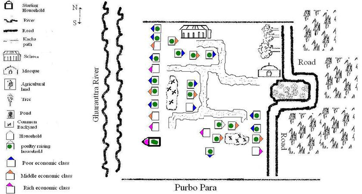
Figure 2. Social/natural resource map (picture of social mapping of “Purba para” in Netrokona, Bangladesh 2008.
Data collection and registration
Having knowledge on how local people know the society around them and which areas are more important to them, apart from specialized GIS maps, helps facilitators to gain a better understanding of the region and main concerns of people. This goal was achieved by using social and ecological mapping techniques, semi-structured interviews, and site visits. In addition, this step paved the way for dialogue to advance the next steps and determined what issues should be addressed in finding the main concerns of people.
Problem tree
It is used to indicate the reasons for a problem. The first step is to identify the main problem and then the causes and effects (Dearden, 2005). This method helps to make sure if we have identified the main causes of the problem or not (Ammani et al., 2010) (Figure 3).
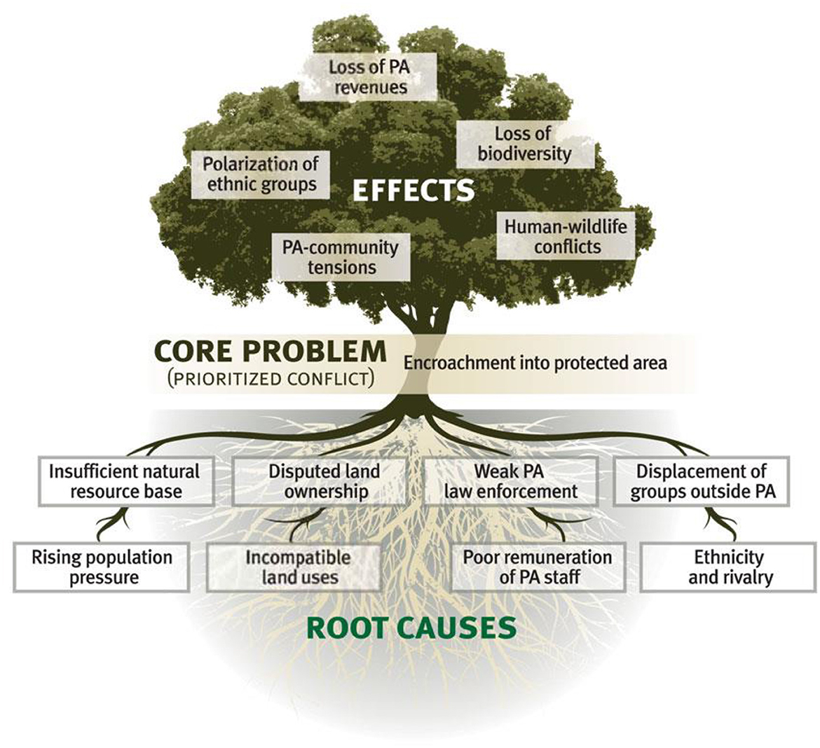
Figure 3. Problem tree (iisd.org).
Historical timeline
The events which are essential to analysts are recorded. Evaluating the changes which have occurred in this region over a period of time can be the key to many questions (Figure 4). This technique starts from the oldest event that analysts remember and each event is written or pasted on a time axis in chronological order (Geilfus, 2008).
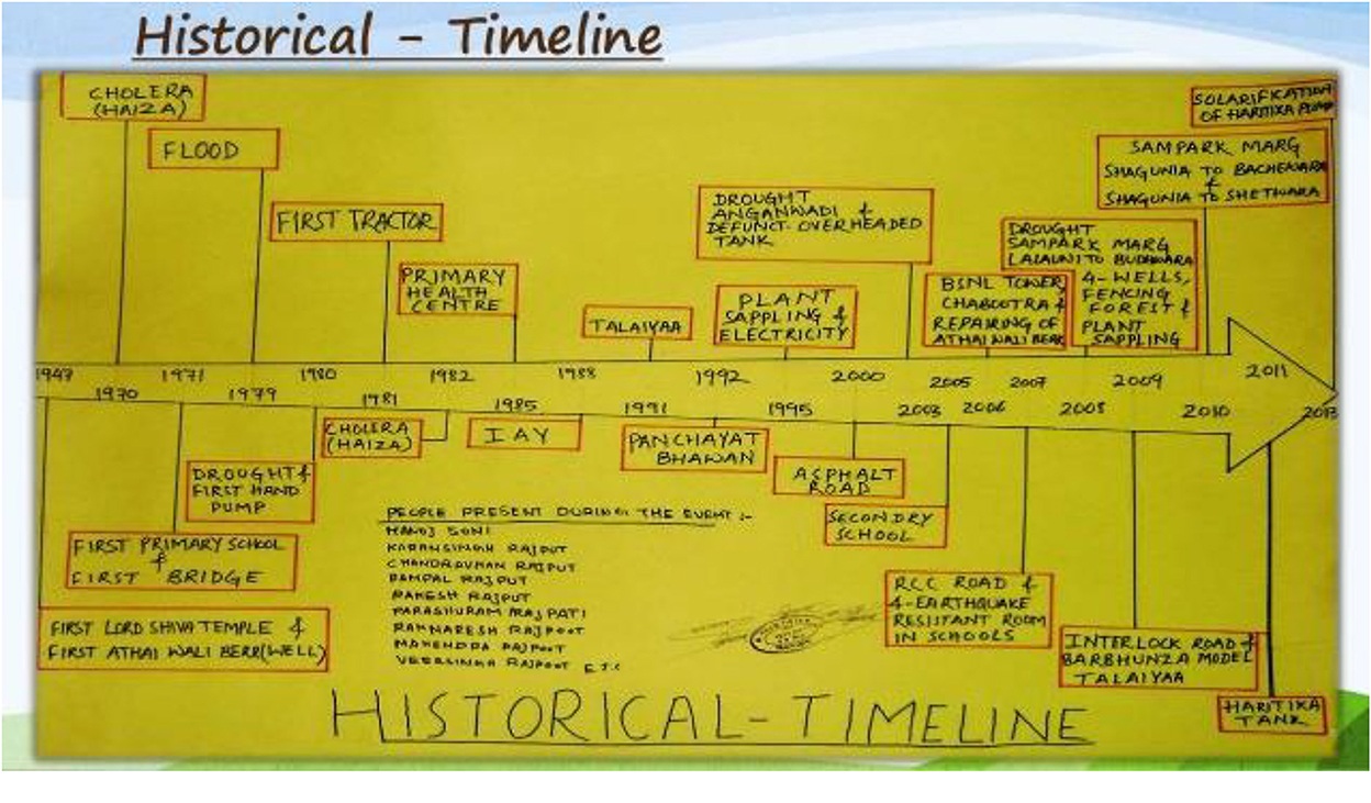
Figure 4. Historical timeline (shagunia maph village 2014).
Before and after chart
It is used to show the changes which occurred before and after a specific time period or event. This chart helps to examine the changes which occur over time in a situation and its consequences.
Data validation
The cornerstone of real data accuracy in participatory approaches is people's words. Listening to the opinions of the majority in a region and involving their views and participation in data registration can inform facilitators if the data accuracy.
Successive field visits, talking about previous findings, making changes proposed by local peoples, drawing transect maps, and long conversations led to the participation of the majority of villagers and increased data accuracy.
Transect map survey
It aims to begin a conversation with a field visit which can be about different issues such as topography, different uses of resources, etc. to study the created problems encountered and the potential for their development by focusing on their applications. To illustrate these features, a kind of diagram is used which may be the starting point for discussing options (Figure 5).
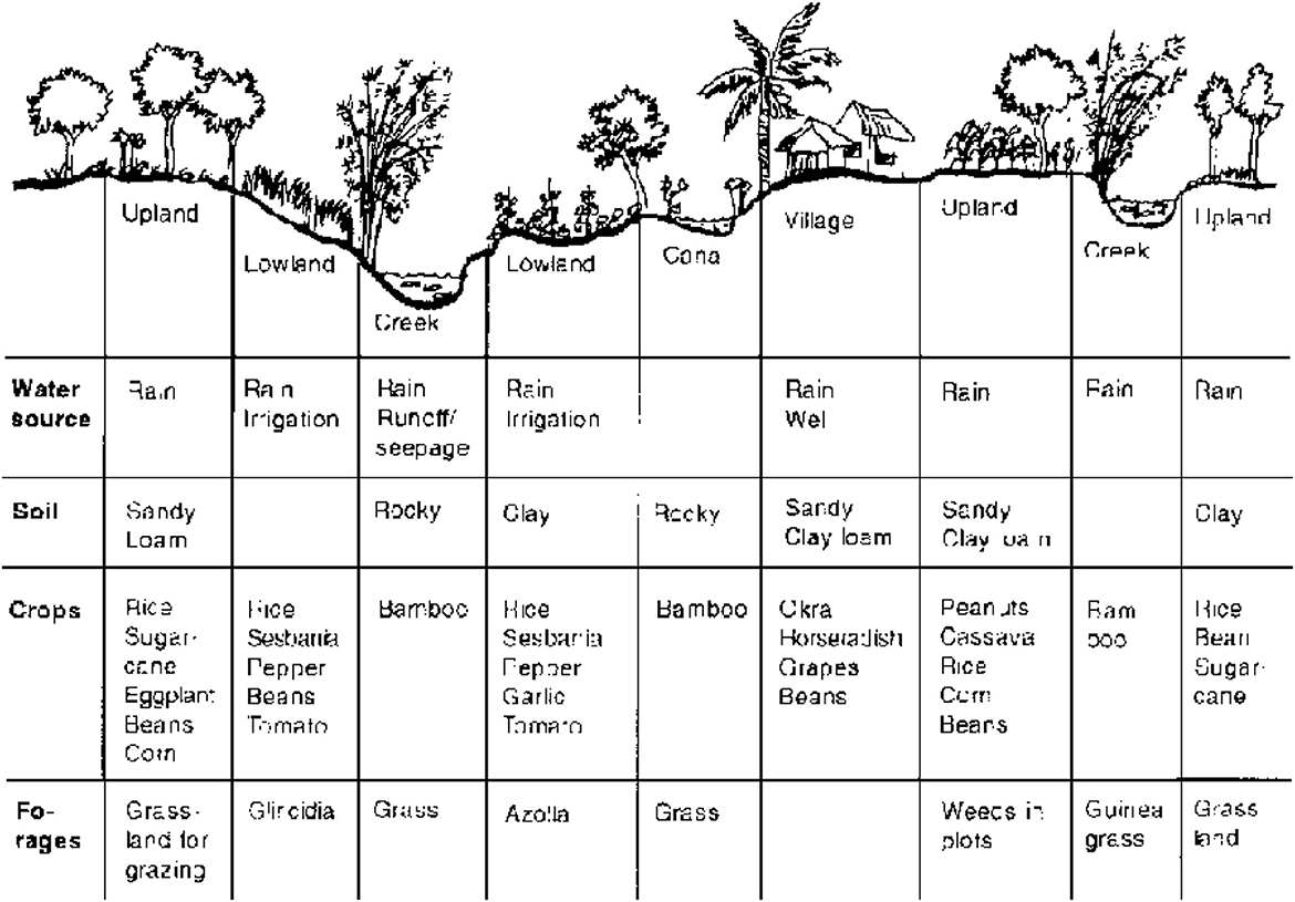
Figure 5. Transect map (nzdl.org).
This diagram can be a simple task for helping people express their knowledge about their environment. In addition, it may improve with data from other resources and can transfer extensive information (Geilfus, 2008) (Figure 6).

Figure 6. Work with locals- Ab-e Ask village.
Results and discussion
Results from the natural/social resource map
Field visits begin with semi-structured interviews with residents and a map of the region including the border and outskirts of Lar National Park, village pastures, crowded roads, contract borders with other villages, and the fish shops and ponds where the locals worked were determined to identify the borders and areas that the local people dealt with (Figure 7). This map identified the sensitive areas in terms of pollution in the river, areas banned by the government for grazing livestock, landfills, and mines by 42 villagers including men, women, and children who worked in different occupations (Table 1).
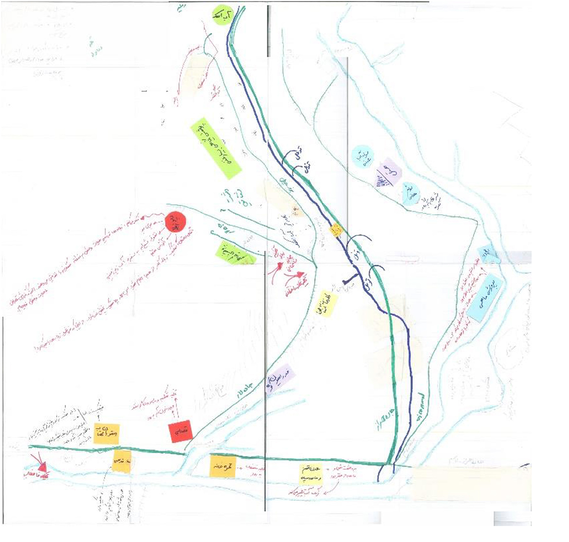
Figure 7. Transect Map- Ab-e Ask village.
Table 1. Results of natural and social resource mapping technique.
The effect of forbidden grazing areas on the livelihood of the people and indicating the Barf-e-Chal region as an old, religious and traditional ritual was one of the significant topics in the visits.
The governmentalization of pastures from 1993 onwards was one of the most essential events which all families complained about due to the livestock with which they earned a living. The villagers were no longer considered as the main owners of pastures after 1993. For this reason, they were deprived of the opportunity to decide on the entry and exit date of livestock to the pastures. On the other hand, any initial construction in which shepherds could live next to their livestock was considered as a crime. Addressing the history of events in the village and the effects of significant events and decisions on people's lives was the second step in finding the answers to the questions. By drawing a diagram of the historical trend, the villagers were asked to record the events which affected their lives according to the historical precedence and latency. Finally, the issue of water pollution was emerged from the discussions (Table 2).
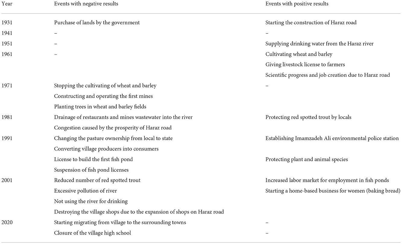
Table 2. Results of the historical trend technique in Ab Ask village.
Results of the chart before and after 1993 (changing the pasture ownership)
This work began with the participation of four villagers and reviewed with other residents. In the meantime, some examples were mentioned for proving the damages caused by the presence of tourists or the protective behaviors of villagers. In addition, the villagers reached a consensus on data accuracy (Table 3).
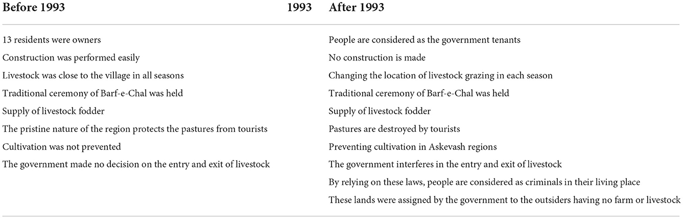
Table 3. Results of before and after using the technique.
A brief look at this technique indicated that life in the village was easier before 1993 and the change of pastures ownership from local to state. At that time, 13 residents from the three villages of Ab Ask, Ziar, and Niak owned the lands and were the main decision-makers in the management of livestock and pasture. Thus, the government had no interference in the entry and exit of livestock and the livestock always grazed near the village. This process led to protective measures of the pastures by the villages to use their own mountain forage every year.
The discussion on land ownership issues revealed two obvious examples of local peoples' protective behavior. The first example was familiarity with Barf-e-Chal (Varf Chal) ceremony. In this ceremony, the people from three villages of Niak, Ziar, and Ab Ask, who benefit from the common resources and interests of a mountain, set a day every year during the religious-traditional ceremony after the last spring snow so that the men of all three villages gather in a region called Barf-e-Chal and store the remaining snow in a pit dug by villagers many years ago. The snow provides water resources to the surrounding pastures by minimizing surface evaporation during the summer. In addition, the water resources available to farmers, livestock, wildlife, and nomads are originated from the melting of this snow. This ceremony has met the livelihood needs of local people and played a key role in supplying water to indigenous plants and wildlife and is a successful example of the indigenous protection of natural resources.
The second protection approach was based on the restrictions that the locals considered as contract on the use of pastures and were bound to it for many years. This issue was addressed by visiting the Askevash region with one of the foresters of Lar National Park who lived in Ab Ask by taking cross-sectional map of the region.
During a field visit to Askevash region with the forester, the landfills, as the regions where polluted water entered and pastures which were protected by local people were visited. Askevash farms on the outskirts of Lar National Park were open to the public and had dense and various vegetation. The people of the three villages of Ziar, Niak, and Ab Ask declared the pastures of this region forbidden from the beginning of spring to the beginning of July to let the plants in the region reach their full growth and after sowing, livestock was allowed to enter the region. As a result, all of the plants in the region became ready for growth during the following year and the domestic livestock could graze.
Results from the problem tree of water pollution
The pollution of the Haraz river was another issue considered by the residents of Ab Ask. In order to evaluate the effects of the river pollution, the issue of water pollution was considered as the main trunk of the problem tree and the reasons were investigated (Figure 8). This issue was reviewed with the maximum cooperation of about 80 residents in a combination of different age groups and genders.
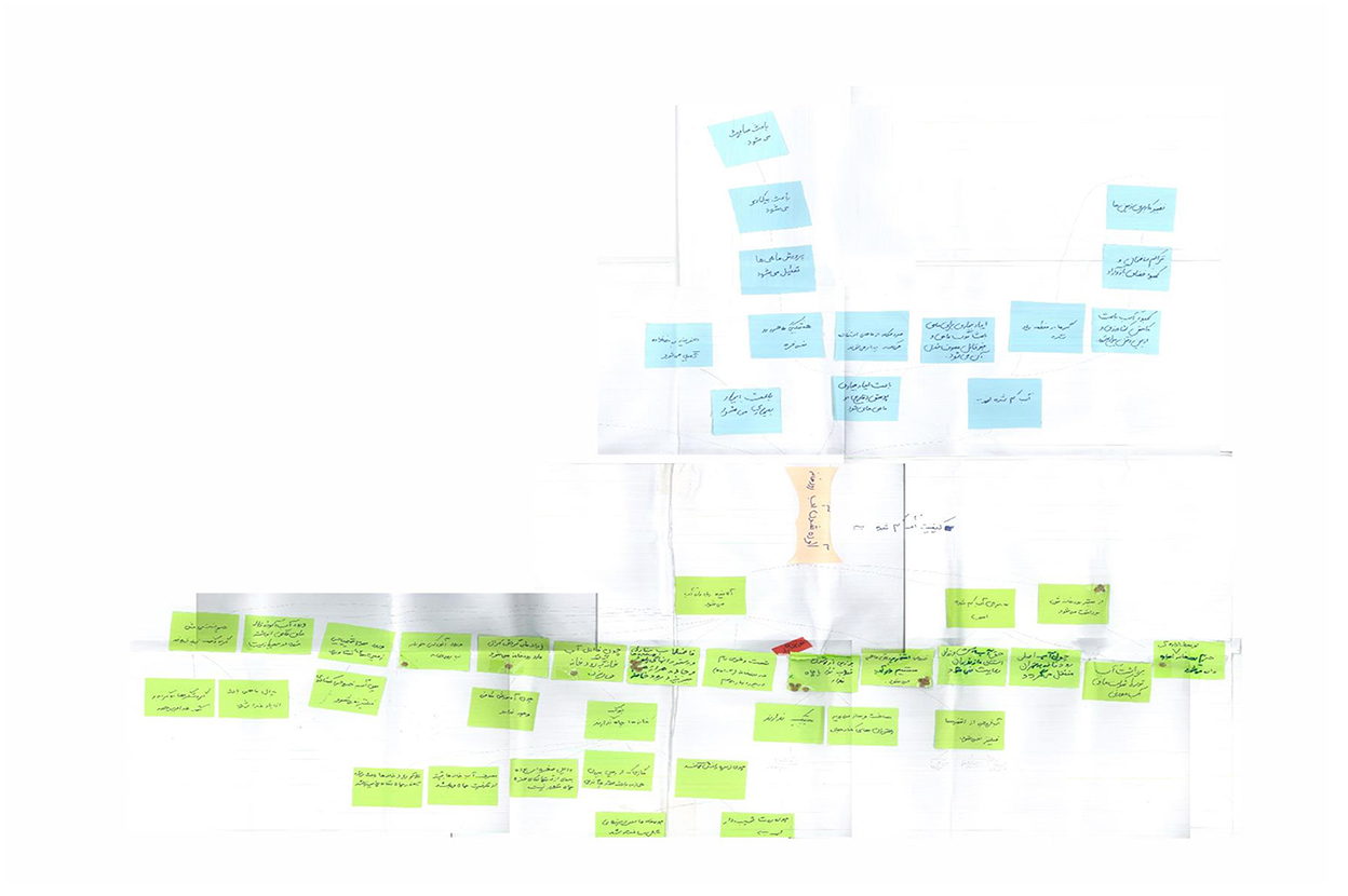
Figure 8. Water pollution problem tree- Ab-e Ask village. The method's chart.
There are some reasons for the Haraz River pollution such as removing sand from the riverbed, reducing of river discharge due to reduced precipitation and non-observance of farmers' water rights, and including some pollutants such as polluted water from fish ponds, domestic wastewater, restaurant wastewater, garbage leachate, butchery blood entering the river.
Finally, the effects of water pollution are as follows.
1. Reduced fish and fishing and its effect on livelihood.
2. Increased skin diseases among the locals.
3. Increased disease between aquatic and river fish.
4. Decreased fishing has led to an increase in agriculture and conversion of lands and pastures into agricultural land.
Conclusion
By referring to the “before and after change of ownership” and “Effectiveness of ownership change” techniques, it can be concluded that the protection laws adopted by external experts fail to have the required function because these laws ignore the needs of livelihood and people have to violate the law to meet their needs. Such violations lead to some damages to the environment and challenge the security of local people by reducing the local people's confidence in the government, as well as their lack of cooperation to improve the situation and create chaos. By reviewing two successful examples of local legislation and evaluating its various dimensions, it is possible to amend the laws passed by the government and involve the people in the decision-making process to increase the efficiency of external laws.
Barf-e-Chal
The annual religious-traditional ceremony of Barf-e-Chal is a good example of sustainable indigenous laws and environmental protection. This ceremony is held every year with the cooperation of the villagers. The accumulation of snow in Barf-e-Chal has a significant effect on supplying water to livestock, wildlife, and nomads in summer and helps to store groundwater. Nobody violates this tradition and people's livelihood is not endangered. All of the residents are aware of the reasons for holding the ceremony in Barf-e-Chal and decide for holding this ceremony.
Enclosing Ask-e-Vash by the people of Ab Ask village: The ranchers of Ab Ask have selected a highly effective method to protect the plants and provide fodder for their livestock. They enclose Ask-e-Vashevery year for 3 months of the growing season and hire guards from the villagers at their own expense so that no one can enter the livestock into the region.After the final growth of the plants and their granulation, the locals harvest the plants, dry the fodder for winter, and use the shortened plants for summer livestock. This solution was selected by the residents of three villages to solve the problems related to livestock.
Relying on these two examples indicates that control-oriented laws without considering the knowledge and needs of people fail to help people be involved in protection but should spend more costs and time for covering the gap between external experts and local people.
If we consider people as the main beneficiaries of the region and the comfort of people's lives depends on the protection of resources around them, the sense of belonging among people will increase and protection will be conducted by people. Thus, the following recommendations are made in this regard.
• To protect the natural environment, it is necessary to identify the real concerns of local people and make decisions to accompany them and protect the region.
• Indigenous knowledge has been experienced as trial and error for years. The details and margins of each region are hidden in indigenous knowledge and no law can have the highest function unless it attempts to observe all details. Thus, the problems and their consequences can be explored as much as possible and the best decision can be made by involving people in decision-making.
• Engagement with local people results in public clarification and public decision-making, which increases local people's confidence in external decisions.
• External experts with their theoretical knowledge along with local people with practical knowledge can better understand the efficiency of the ecosystem components by increasing the empowerment and awareness of both parties.
Although there are many limited items such as time limitations, financial issues, Access to areas, and building mutual trust between local people and experts but we suggest trust in local people's knowledge, patience in listening, and honesty should be the first step of these kinds of projects. Eventually, to the importance of the protection of the rangelands both for Local people and governmental organizations and also due to the results which we found in this research, we suggest providing a trustful, friendly, and respectful atmosphere between locals and governments to communicate about conservation approaches and using the Indigenous Knowledge. Gathering data, making decisions, and executing the decisions with local people and governments can be a valuable step toward preserving indigenous, biological, social, and cultural values. improving the projects which are attending to the economic and social needs of the people, the government, and experts are considered can be considered a great help in protecting and managing natural resources.
Data availability statement
The original contributions presented in the study are included in the article/supplementary material, further inquiries can be directed to the corresponding author.
Author contributions
AA: supervision. MR: data gathering, analyzing, and writing the manuscript draft. HM: methodology design and checking the data. HV: methodology design and supervision. SB: filed work. All authors contributed to the article and approved the submitted version.
Conflict of interest
The authors declare that the research was conducted in the absence of any commercial or financial relationships that could be construed as a potential conflict of interest.
Publisher's note
All claims expressed in this article are solely those of the authors and do not necessarily represent those of their affiliated organizations, or those of the publisher, the editors and the reviewers. Any product that may be evaluated in this article, or claim that may be made by its manufacturer, is not guaranteed or endorsed by the publisher.
References
Ammani, A. A., Auta, S. J., and Aliyu, J. A. (2010). Challenges to sustainability: Applying the problem tree analysis methodology to the ADP system in Nigeria. J. Agri. Extens. 14, 35–45. doi: 10.4314/jae.v14i2.64122
Brook, R. K., and McLachlan, S. M. (2008). Trends and prospects for local knowledge in ecological and conservation research and monitoring. Biodiver. Conserv. 17, 3501–3512. doi: 10.1007/s10531-008-9445-x
Chambers, R. (1993). Challenging the Professions: Frontiers for Rural Development. Intermediate Technology Publications Ltd (ITP).
Cornwall, A., and Pratt, G. (2011). The use and abuse of participatory rural appraisal: reflections from practice. Agric. Hum. Values 28, 263–272. doi: 10.1007/s10460-010-9262-1
Dang, W. (2020). How culture shapes environmental public participation: case studies of China, the Netherlands, and Italy. J. Chin. Govern. 5, 390–412. doi: 10.1080/23812346.2018.1443758
Dearden, P. N. (2005). A positive look at monitoring, review and evaluation-international development experiences affecting regeneration work in the UK. University of Wolverhampton, Wolverhampton, United Kingdom.
Geilfus, F. (2008). 80 Tools for Participatory Development: Appraisal, Planning, Follow-Up and Evaluation (No. 303.4 G312e). San José: IICA.
Hossein Bar, M., and Rustakhiz, B. (2017). Rural participatory assessment approach challenges and criticisms (Ph.D. Thesis). University of Sistan and Baluchestan, Zahedran, Iran.
McIntosh, M. J., and Morse, J. M. (2015). Situating and constructing diversity in semi-structured interviews. Glob. Qual. Nurs. Res. 2, 2333393615597674. doi: 10.1177/2333393615597674
Minkler, M. (2000). Using participatory action research to build healthy communities. Public Health Rep. 115, 191. doi: 10.1093/phr/115.2.191
Molle, F. (2007). Scales and power in river basin management: the Chao Phraya River in Thailand 1. Geograph. J. 173, 358–373. doi: 10.1111/j.1475-4959.2007.00255.x
Papadakis, P., Spalanzani, A., and Laugier, C. (2013). “Social mapping of human-populated environments by implicit function learning,” in 2013 IEEE/RSJ International Conference on Intelligent Robots and Systems (Tokyo: IEEE), 1701–1706. doi: 10.1109/IROS.2013.6696578
Poppe, M., Weigelhofer, G., and Winkler, G. (2018). “Public participation and environmental education,” in Riverine Ecosystem Management eds S. Schmutz and J. Sendzimir (Cham: Springer), 435–458. doi: 10.1007/978-3-319-73250-3_22
Rudqvist, A., and Woodford-Berger, P. (1996). Evaluation and Participation: Some Lessons. Stockholm: Swedish International Development Cooperation Agency.
Keywords: people-nature links, environmental sociology, participation, local people, natural resources
Citation: Rakhshan M, Mahmoudi H, Abdoli A, Veisi H and Babrgir S (2023) The interaction of local people and natural area in Haraz drainage basin; Case study: Ab-e Ask village. Front. Water 4:949691. doi: 10.3389/frwa.2022.949691
Received: 21 May 2022; Accepted: 31 August 2022;
Published: 01 March 2023.
Edited by:
Reza Kerachian, University of Tehran, IranReviewed by:
Naser Valizadeh, Shiraz University, IranMoslem Savari, Khuzestan University of Agricultural Sciences and Natural Resources, Iran
Copyright © 2023 Rakhshan, Mahmoudi, Abdoli, Veisi and Babrgir. This is an open-access article distributed under the terms of the Creative Commons Attribution License (CC BY). The use, distribution or reproduction in other forums is permitted, provided the original author(s) and the copyright owner(s) are credited and that the original publication in this journal is cited, in accordance with accepted academic practice. No use, distribution or reproduction is permitted which does not comply with these terms.
*Correspondence: Asghar Abdoli, QV9BYmRvbGlAc2J1LmFjLmly