 Sampson K. Agodzo
 Enoch Bessah
 Mexoese Nyatuame
- 1Department of Agricultural and Biosystems Engineering, Kwame Nkrumah University of Science and Technology, Kumasi, Ghana
- 2Department of Agricultural Engineering, Ho Technical University, Ho, Ghana
An extensive narrative review approach is adopted to present existing information on the consumptive and non-consumptive uses and their related issues, such as floods and droughts, climate and the environment in Ghana. Total annual rainfall in the country ranges between 800 mm/y (south-east coat) and 2,000 mm/y (south-west coast) with a bimodal and mono-modal patterns in the south and north, respectively. Annual total runoff from the 3 river systems (the Volta river system, the South-western river system and the Coastal river system) in Ghana is estimated at 40 billion m3 out of about 53 billion renewable freshwater resources. Groundwater yields ranges from 6 m3/h in the Volta basin sedimentary formations to 180 m3/h in the limestone formations. It is estimated that the total water withdrawal as a percentage of total renewable water resources is about 2%. At an average per capita consumption of water of 50 l/p/d, estimated daily water demand for the 2021 population of 31 million people stands at about 566 million m3/y. Current water supply systems are overstretched and it is further estimated that about US $ 240 million is required per year as capital expenditure in urban and rural water supply. Moreover, climate change is projected to increase the scarcity of water in future. Wastewater generated through domestic and industrial uses including storm water in urban Ghana is estimated at about 760 million m3/y. Ghana's irrigation potential to reduce climate change impact on agriculture is put at between 0.36 and 2.9 million ha, accounting for about 66.4% of the consumptive water withdrawal. Estimated water demand for cattle, sheep and goats in 2010 was put at about 22 million m3/y. Other services obtained from surface water are the provision of fish (the Volta Lake is estimated to contributes to 16% of total catch in Ghana); hydropower generation accounting for about 40% of total power installed capacity (Akosombo = 1,020 MW, Kpong = 160 MW, and Bui = 404 MW); water transportation (notably on the Volta Lake); tourist attractions [are 550 km Ghana's shoreline that has about 90 lagoons, the Volta Lake, the lower Volta (e.g., Sogakope, Ada) and some other inland waters like Lake Bosumtwi] and wetlands (recognized by RAMSAR convention of 1971) In the legal context, water governance issues are handled by various institutions created by Acts of Parliament.
1. Introduction
Ghana is located in West Africa, bordered on the north by Burkina Faso, on the east by Togo, on the west by Cote D'Ivoire and on the south by the Gulf of Guinea. It has a land area of ~240,000 km2. Ghana used to have 10 administrative regions but on 27 December 2018, the map of the country changed to 16 administrative regions following a referendum on the creation of six additional regions. Water is a cross-cutting issue in the developmental agenda of Ghana and relevant to enhancing livelihood, growth, and good health. Water deficit areas (northern Ghana) face more severe development challenges than southern Ghana which is comparatively wetter. In Ghana, water as an economic good has been considered in all the United Nations (UN) water-related programmes such as the Water and Sanitation Decade, Millennium Development Goals (MDGs), New Partnership for African Development (NEPAD), and now the Sustainable Development Goals (SDGs) in addition to national programmes such as the Ghana Poverty Reduction Strategy (GPRS) (Ministry of Water Resources, Works and Housing, Ghana (MWRWH), 2007). The objective of this paper is to review the trends of water use and availability in Ghana in the context of climate change impact on water resources and the implication for sustainable development.
2. Method
An extensive narrative review approach is adopted to present existing information, using the web search engine, snowballing and other reports, on the water resources availability and uses in relation to the direct and indirect impacts of climate change. The topical issues reviewed are the hydrometeorology, river systems, groundwater, reservoirs, wetlands, water quality, wastewater, sedimentology and water-induced erosion, water supply, irrigation animal watering, hydropower generation, inland water transport, inland fisheries, water-related tourism, the water sector in a changing climate (floods, droughts) and water legislation and water sector institutions. Literature on the Volta, Pra, and Densu basins were of interest because of their roles and coverage in the three river systems of Ghana.
The remaining part of the study is grouped under six sections. Section 3 focuses on climate of Ghana (water year, rainfall, evapotranspiration, and humidity); section 4 is on Water resources in Ghana (River systems, Groundwater, Reservoirs, Wetlands); section 5 on Climate change and impacts on water resources (Quantity and Water quality); section 6 on Water uses (Consumptive and non-consumptive water uses, and wastewater); section 7 on Existing water legislation and water sector institutions and section 8 on the Implication of this study and way forward.
3. Climate of Ghana
The water year in Ghana starts on the first day of March each year and ends on the last of February the following year. Officially, the wet season begins on the first day of March while the dry season ends on the last day of February. However, there are some spatial variations in the hydrological calendar.
3.1. Rainfall
Total rainfall in the country decreases spatially from 1,800 mm/y on the south-west coast through 1,250 mm/y in the mid belt to about 1,000 mm/y in the north, averaging at about 1,200 mm for the period 1981–2010 (Bessah et al., 2021a). The least total rainfall is recorded in the south-east at about 750–850 mm/y (Bessah et al., 2021a).
Rainfall is bimodal in the south and mono-modal in the north and the northern parts have higher water deficits due to the high excesses of evapotranspiration over rainfall (Bessah et al., 2021a). The average annual rainfall about 1,200 mm should be sufficient to grow most of the staples in Ghana (Incoom et al., 2022). The coastal savannah belt of Ghana which records the least rainfall has average annual rainfall of about 800 mm/y. Except in cases of occasional extreme climatic conditions that lead to the destruction of crops, rainfall amounts can be described as adequate for most crops, but the distribution has been uneven both geographically and seasonally. Crop water requirements for tomato and onions were projected to increase by about 50 mm/growth period under climate change in the twenty-first century over a base period records in the range of 500–580 mm/growth period in the Guinea Savannah zone of Ghana (Incoom et al., 2022). Water surplus of rainfall over potential evapotranspiration is higher in the south than the north for the wet months. At the same time, water deficits of rainfall over potential evapotranspiration are smaller in the south than the north for the dry months. This explains why even though the north has good amounts of rainfall, the much higher potential evapotranspiration rates results in huge water deficits for plant growth. Hence the need for irrigation in especially the north of Ghana (Agodzo et al., 2014).
Hydrometeorology refers to the water-related climate parameters. It includes all forms of precipitation, evapotranspiration and the humidity of the air. Table 1 presents the average data for rainfall, evapotranspiration and relative humidity at representative gauging stations in Ghana.
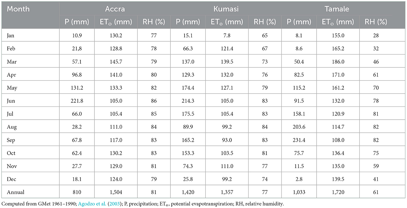
Table 1. Rainfall, potential evapotranspiration and relative humidity for Accra, Kumasi, and Tamale.
3.2. Evapotranspiration
Evapotranspiration determination in Ghana is usually through empirical estimation. Acheampong (1986) compared three methods for the estimation of ET and concluded that the Penman method works best for Ghana. Salifu et al. (2011) successfully employed the Surface Energy Balance Algorithm for Land (SEBAL) model to estimate actual evapotranspiration (ETa) for different land use/cover types for the Atankwidi and Afram catchments in the Volta Basin of Ghana, with values ranging between 1.4 and 7.30 mm/d across the catchments.
3.3. Relative humidity (RH)
There are hardly any relative humidity studies in Ghana. In Table 1, relative humidity (RH) reduced from Accra (81%) on the southern coast through Kumasi (77%) in the middle belt to Tamale (61%) in the northern belt, implying air moisture depletion from the south to the north. Frimpong et al. (2014) in a study in Bawku East reported a rising trend of relative humidity at Garu, while trends in Manga and Binduri did not show clear patterns in rise or fall for the period 1961–2012. Recent study based on the reference period of 1976–2018 showed that RH increases spatially from the coast (60–85%) through the forest (30–80%) to the savannah (30–70%) agro-ecological zones (Bessah et al., 2022).
4. Water resources in Ghana
4.1. The river systems
Ghana has a land area of ~240,000 km2. The country is endowed with 3 river systems: the Volta river system, the South-western river system and the Coastal river system (Figure 1). The catchment area of the Volta basin extends into six riparian countries (Ghana, Burkina Faso, Cote d'Ivoire, Mali, Togo, Benin) covering a little over 400,000 km2. The main tributaries of the Volta river are the Black Volta, White Volta Red Volta, and the Oti rivers. About 85% of the catchment area of the Volta basin is shared between Ghana and Burkina Faso and 15% shared between the other four countries. The Volta Basin Authority (VBA) was established by the riparian countries to manage the basin as an international resource and by 2010, five riparian countries except Cote d'Ivoire signed the VBA agreement bringing the convention into effect. Cote d'Ivoire later joined.
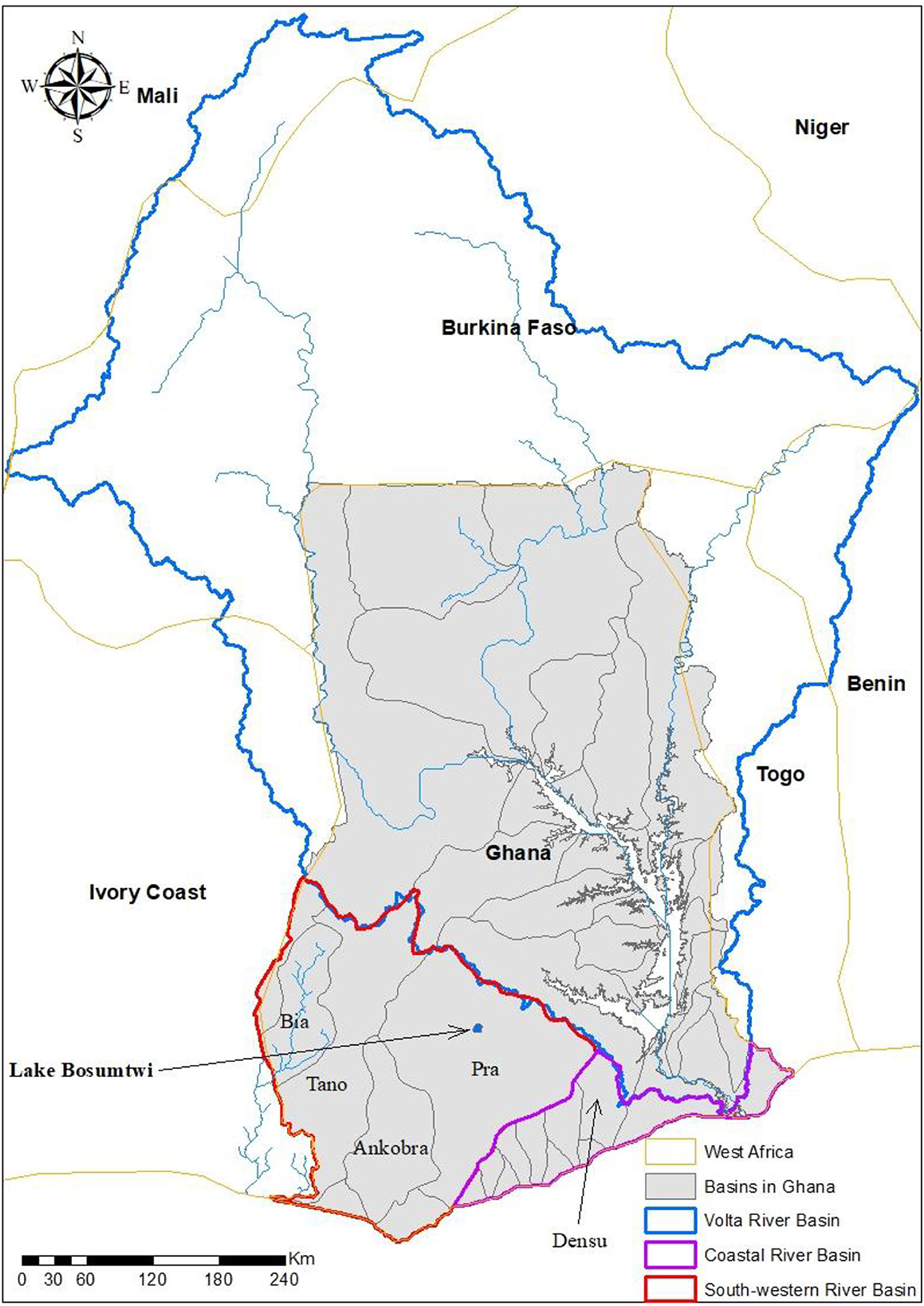
Figure 1. Basin demarcation for the 3 river systems in Ghana.
The Volta river system drains about 70% of Ghana of the total land area of about 240,000 km2 and the other 2 river systems drain the remaining 30% in the proportion of 22% (South-west river system) and 8% (Coastal river system). Estimated total annual mean runoff for Ghana is about 53.2–54.4 billion m3 of water, of which nearly 40 billion m3, or 68.6%, is generated within Ghana's borders (Water Research Institute (WRI), 2010; Agodzo et al., 2014). The remaining 31.4%, or 15 billion m3, is generated outside Ghana's borders. Some estimates put the annual runoff proportion at 65, 29, and 6%, respectively, for the Volta, South-western, and the Coastal river systems [Ministry of Water Resources, Works and Housing, Ghana (MWRWH), 2007; Water Research Institute (WRI), 2010; Aidoo et al., 2021]. The largest basin in the South-western river system is the Pra basin supplying four regional capitals and leading producer of tuber crops in the country (Obuobie et al., 2012b; Bessah et al., 2020a). The Densu basin in the coastal river system is of key importance to water supply in Accra, the capital of Ghana. The Bia river is shared with Cote d'Ivoire, while the lower reaches of the Tano river also form part of the boundary with Cote d'Ivoire (Figure 1). The upper reaches of the Tordzie river in the Coastal system shares boundary with Togo (Ministry of Water Resources, Works and Housing, Ghana (MWRWH), 2007; Nyatuame et al., 2020).
4.2. Groundwater
Ghana is underlain by three main geological formations, namely the basement complex comprising crystalline igneous and metamorphic rocks; the consolidated sedimentary formations underlying the Volta basin (including the limestone horizon) and the Mesozoic and Xenozoic sedimentary rocks. These formations represent 54, 45, and 1% of the country, respectively [(Ministry of Water Resources, Works and Housing, Ghana (MWRWH), 2007; Water Research Institute (WRI), 2010; Water Resources Commission (WRC), 2012a,b)]. The depth of aquifers in the basement complex and the Volta basin is normally between 10 and 60 m with yields rarely exceeding 6 m3/h. The aquifer depths in the Mesozoic and Xenozoic formations are usually between 6 and 120 m with average yields of about 184 m3/h particularly in the limestone aquifer. Groundwater occurrences in limestone formations, which also exist, are much deeper located, typically in the range of 120–300 m. The average yield in the limestone formation is 180 m3/h.
Recharge is usually in the form of direct infiltration of precipitation through fracture and fault zones along the highland fronts and also through the sandy portions of the weathered zone. Some recharge also occurs indirectly as seepage from ephemeral stream channels and pools of accumulated runoff in the rainy seasons. Estimated recharge values are generally low, varying from 1.5 to 19% of annual rainfall, and there is high spatial and temporal variability. Additional recharge occurs through seepage from ephemeral stream channels during the rainy season. There are saline intrusions in shallow aquifers along the coastal zone, while borehole yields in the Northern, Upper East, Upper West, and parts of Brong-Ahafo regions are often in-sufficient with some occurrence of “dry boreholes.” There are also problems of high iron and fluoride contents in parts of the country including the Western, Northern, and Upper East regions (UPgro African Groundwater Country Study, 2020).
Groundwater recharge studies are few. For example, recharge estimates by Obuobie et al. (2012a) in the White Volta River basin of Ghana (~46,000 km2) for the 2006 and 2007 water years showed high seasonal and spatial variability in the water level, with a range of 1.24–5.00 m in 2006, and 1.60–6.80 m in 2007. Water level rise occurred only in the rainfall season and recharge to groundwater estimated to vary between 2.5 and 16.5% of the mean annual rainfall. In another study, Obuobie et al. (2013) assessed the groundwater resource potential for dry-season vegetable irrigation in two areas of north-eastern Ghana. By using geophysical surveying, recharge estimation, and water quality analysis, they found that groundwater abstractions for all purposes are small compared to recharge. Establishing that groundwater was generally suitable for irrigation, they concluded that the use of groundwater for dry-season irrigation could be expanded 14–18-fold in the study areas.
Ghana shares in two main transboundary aquifers, both of which are coastal: The Tano aquifer system, located in the extreme southwest of Ghana and shared between Ghana and Cote d'Ivoire. It covers an area of 806 km2 in Ghana and includes three aquifer units (Quaternary, continental terminal and Maastrichtian); and the Keta aquifer system, found in the extreme southeast of Ghana and shared among Ghana, Togo, Benin, and Nigeria. It is a layered system covering an area of 2,721 km2 (UPgro African Groundwater Country Study, 2020).
4.3. Reservoirs
Lake Bosumtwi, about 30 km south-east of Kumasi in Ashanti (Figure 1), is a natural lake formed from a meteorite impact. From an areal view, it looks almost circular, where the rim of the crater has a diameter of about 10.5 km. The water surface area which is below the rim of the crater is said to have a diameter of 8 km (Koeberl et al., 2007), working out to a surface area of about 50 km2 and a maximum depth of 78 m (Ministry of Water Resources, Works and Housing, Ghana (MWRWH), 2007). There are 30 settlements dotted around the lake. Lake Volta, as shown in Table 2, is a man-made lake and one of the most studied lakes in Ghana (Van de Giesen et al., 2010; Codjoe et al., 2020; Nyadzi et al., 2021). It is the largest impoundment with a capacity estimated between 148 and 153 km3 when the Akosombo dam was constructed for hydropower generation in 1964 (NASA, 2018).
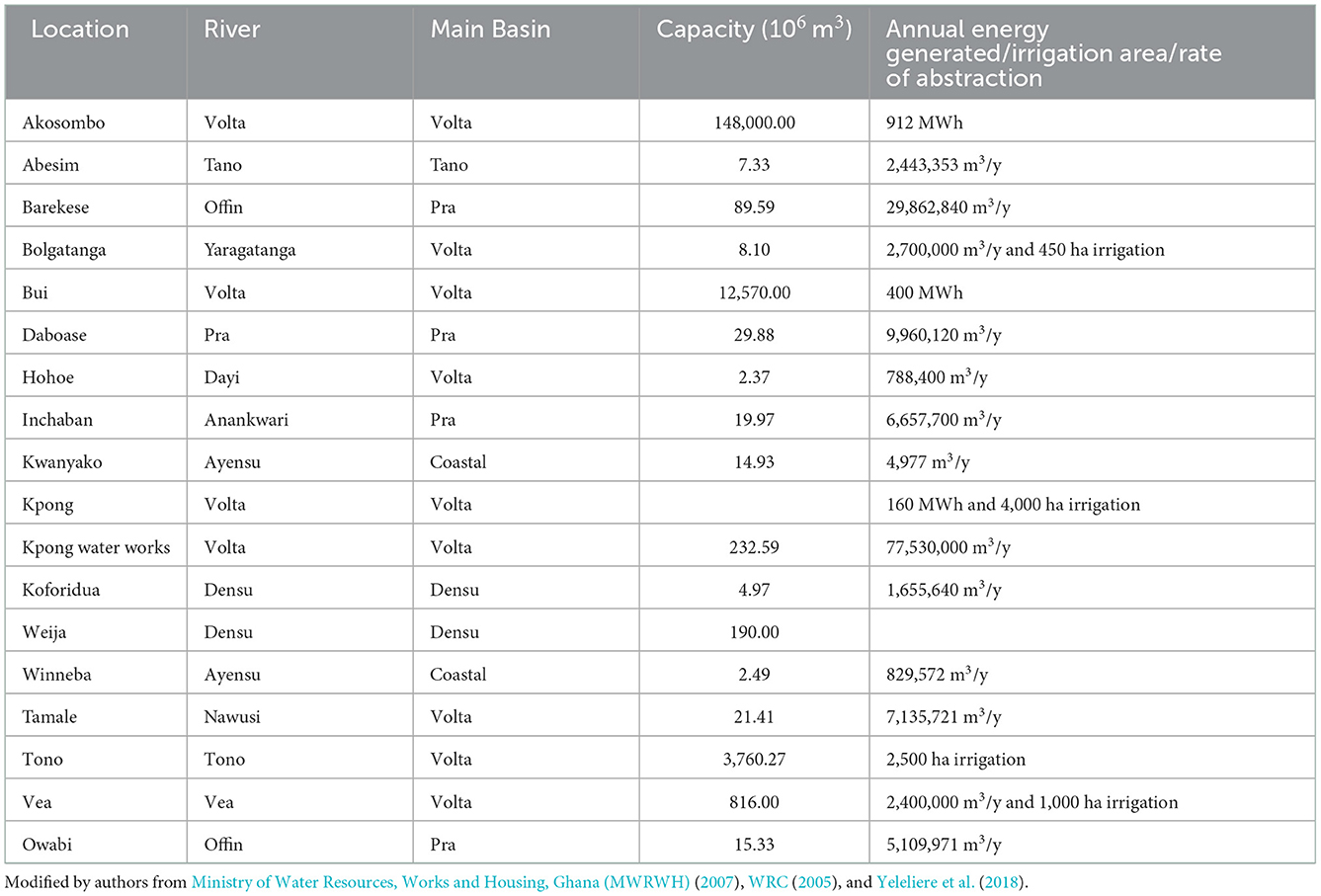
Table 2. Characteristics of some major reservoirs or impoundments in Ghana and their estimated annual generation rate or irrigation surface or abstraction rate.
Other notable man-made reservoirs in Ghana (Table 2) include the Bui reservoir (12.57 km3), Tono (3.76 km3), Vea (0.82 km3), and Kpong (0.23 km3) [Ministry of Water Resources, Works and Housing, Ghana (MWRWH), 2007; WRC, 2005; Yeleliere et al., 2018] and either used for water supply, irrigation or hydropower generation. The total inland water area, which includes the Volta Lake, Lake Bosomtwi, and others, is about 11,800 km2 (United Nations Convention to Combat Desertification, 2015). For an average annual rainfall over Ghana between 1,170 and 1,200 mm, the total direct precipitation on the inland water surfaces works out to ~14 billion m3 (14 km3) per annum.
There are smaller impoundments scattered across the country, especially in northern Ghana. Ghansah et al. (2018) studied the small impoundments in the White Volta basin based on remote sensing techniques and ground truthing. They estimated that there are ~254 small reservoirs of surface areas between 1 and 53 ha in the sub-basin. The combined surface area and volume of the small reservoirs were estimated to be 1585.265 ha and 21.154 million m3, respectively.
4.4. Wetlands
The discussion here does not include large and small natural and man-made impoundments but limited to the coastal lagoons, mangroves and the flood plains. Wetlands which were originally considered as “wastelands,” have been recognized in Ghana in the context of the RAMSAR convention of 1971 as important for providing habitat for wildlife, maintenance of the water table, mitigation of flood conditions, water purification, fishing, hunting, food production, and generation of other economic activities. Public awareness was created on the benefits and functions of wetlands in a coastal Wetlands Management Project undertaken from 1996 to 1999 The notable lagoons (Sakumono, Songor, Keta, Muni-Pomadze) were designated as RAMSAR sites in 1992 [Ministry of Lands and Forestry (MLF), 1999].
Important RAMSAR sites are: Sakumono Lagoon, near Tema in the Greater Accra Region covering 13.64 km2; Songor Lagoon outside Ada and on the west of Lower Volta River estuary in the Greater Accra Region, covering 28.7 km2; Keta Lagoon, on the east coast of Ghana, extending about 126 km inland, covering about 1,200 km2; and Muni-Pomadze Lagoon, west of the coastal town of Winneba, ~55 km west of Accra, covering about 9.5 km2 [Akyeampong, 2001; Willoughby et al., 2001; Environmental Protection Agency (EPA), 2004; RAMSAR, 2007; Okyere et al., 2012; Adu Kumi and Apraku, 2015; Ramsar Sites Information Service (RSIS), 2022]. The Keta Lagoon is the largest of the 90 lagoons on the 550 km coastal stretch of Ghana. The roles these wetlands play in the natural ecosystem functioning include but not limited to flood attenuation and control, maintenance of underground and surface water supplies, sediment trapping, erosion control, pollution abatement, and provision of habitats of rich biodiversity. In Ghana, they have provided such economic functions as fishing, salt harvesting, water transport, tourism, and water supply (freshwater lakes).
Corcoron et al. (2007) put the total mangrove area in Ghana at 137 km2. Mangroves are found in nearshore lagoons and estuarine environments. The notable ones are found in the Volta and Densu deltas and the western coastline between Cote d'Ivoire and Cape Three Points on the Western coast of Ghana. Anthropogenic activities have resulted in the harvesting of mangrove wood for fish traps and firewood and have resulted in drastic reduction in fish stock.
Almost flat and featureless, the flood plains tend to be swampy in the rainy season and stretch from the lowlands of the coastal west to the coastal east and to the foot of the Akwapim-Togo ranges. The Keta-Avu plain into which the Tordzie-Aka river discharges is one of the notable flood pains in Ghana, with the heavy clays and serves as an important agricultural area. Logah et al. (2017) did hydrodynamic study impacts of dam water releases from the Akosombo and Kpong hydropower facilities on downstream communities along the Lower Volta River. Combined with some sediment studies, they concluded through simulations that large areas downstream of the dam including its flood plains would be inundated if dam releases came close to or exceeded 2,300 m3/s, recommending relocation of communities along the banks and in the flood plains of the Lower Volta River.
5. Climate change and impacts on water resources
5.1. Climate change and rainfall, evapotranspiration and RH dynamics
A number of studies on rainfall in Ghana have been in relation to the air masses that affect the wet and the dry seasons in West Africa. The dynamics of the West African Monsoon (moisture-laden south-west air mass) and the Harmattan (dry and dusty north-east air mass) do determine the seasons in Ghana and onset, cessation, and length of rainfall season (LRS). The main conclusions of such studies were that the length of the rainfall season has been changing with delayed onset and early cessation of the rains. This is affecting agricultural production a great deal. This has led to mitigation measures as the breeding of short-duration and drought-resistant crop varieties, in order to cope with the changes in the length of the rainfall season (e.g., Omotosho et al., 2000; Amekudzi et al., 2015; Kumi and Abiodun, 2018). Some of the rainfall-related studies were about rainfed agriculture, with reference to rainfall onset, cessation and length of rain days. For example, Bessah et al. (2020a) reported possible increase in LRS from two models and decrease in LRS from three models for the period 2020–2049 in the Pra river basin of Ghana. Kwawuvi et al. (2022) studied the rainfall onset, cessation and the length of rain days in the Oti river basin reporting possible future increasing variability in onset and cessation of rainfall that could exacerbate the vulnerability of rainfed agricultural production, recommending drought-resistant varieties as mitigating measures for farmers in the basin.
Logah et al. (2017) surveyed 77 meteorological stations in Ghana and showed that there had been a general decline in the distribution of rainfall in the entire country. This trend, they attributed to such anthropogenic activities as deforestation, poor farming practices, overgrazing, harvesting wood for energy, and bushfires. Some other studies (e.g., Ampadu, 2008; Ampadu et al., 2019) were localized and mostly came up with similar conclusions on rainfall, even though some showed some increasing trends. Asante and Amuakwa-Mensah (2015) also projected low rainfall occurrence in 2020, 2050, and 2080, corroborating similar studies. Bessah et al. (2021a) projected rainfall amount to generally increase in the range of 10–40% and 8–38% under RCP4.5 and RCP8.5 emission scenarios over Ghana in the twenty-first century.
Evapotranspiration as a major component of the hydrological cycle was projected to increase by 6.3% from the baseline by 2050 in the Tordzie basin (Nyatuame et al., 2020). The potential crop evapotranspiration for rice, tomato and pepper were estimated as 697, 533, and 427 mm/season, respectively (Sadick et al., 2014). Aidoo et al. (2021) also argued that climate change is having an adverse effect on the environment especially in sub-Sahara Africa, where capacity for natural resource management such as water is very low. They considered water loss from the environment in the form of evapotranspiration (ET) as a major component in the hydrological cycle. Understanding its spatial dimensions is critical in evaluating the effects it has on regional land use, thus employing METRIC method to create evapotranspiration map for land use in Kintampo North Municipal area for Ghana. The found November and February ET in the range of about 38–87% and 29–52%, respectively.
On RH, Dwamena et al. (2022) did multiple linear regression analyses, relating maize, cassava and yam yield to climatic parameters in the Ashanti region of Ghana, and concluded, among other things, that a unit increase in RH resulted in a yield decrease of maize by 0.001 t/ha; a unit increase in RH resulted in a yield increase of cassava by 1.219 t/ha; a unit decrease of RH resulted in a yield increase of yam by 0.385 t/ha. Climate change could exacerbate these dynamics in Ghana.
5.2. Surface water quality
Water quality studies are many but there is hardly any long-term water quality data (Karikari and Ansa-Asare, 2006; Leslie, 2010; Bessah et al., 2021b). Most water quality studies have reported on the testing of occasional samples taken from surface sources. The non-regular water quality tests have mostly been blamed on financial constraints but the difficulty of such data is that it does not tell the full story of the changes occurring in the water quality for informed management decisions to be made.
The most authentic studies based on regular rather than occasional water sampling were observations of weekly bacterial counts throughout the water column of the Volta Lake at Ajena (a lake shore settlement) from August 1964 to December 1965. The results showed that during the rainy season bacterial populations increased; the contrary being true in the dry months (Biswas, 1967). Goski (1999), Karikari and Ansa-Asare (2006), Asamoah-Boateng (2009), Leslie (2010), and Cobbina et al. (2010), reported on biological quality of dugout and river water sources indicating high bacterial contamination in some cases and recommending treatment for such waters if they were to be used for domestic purposes.
Mining activities in the south-western river system (Pra, Tano, Birim, Offin, Bia, Ankobra) of Ghana have also attracted a lot of attention, where mining-related chemical contamination of such surface and groundwater sources have become major concerns. A few of such studies will be reported here. Asamoah-Boateng (2009) indicated that arsenic (As), iron (Fe), and lead (Pb) were the most predominant mining-related metallic pollutants found in most water bodies. Asante (2012) reported mining-related contaminants detected in water samples as: As (<0.001–0.002 mg/), Cu (0.002–0.04 mg/l), Mn (0.10–0.72 mg/l), and Fe (0.32–3.04 mg/l). Kusimi (2014), in his study on sediment yield and bank erosion assessment of Pra river basin asserted that “the Pra River Basin has been engulfed by certain anthropogenic activities particularly illegal small-scale mining (popularly called galamsey) and serious concerns have been raised by stakeholders within the basin of the level of pollution due to the release of chemicals and sediments into the water bodies.” Bessah et al. (2021b) also did some studies on the Pra, Birim, and Offin river basins on mining-related contamination and reported the following levels of contaminants: As (0.002–294.429 μg/l); Cd (0.001–1.366 μg/l); Cu (0.036–403.787 μg/l); Fe (0.125–429.145) mg/l); Hg (0.005–7.566 μg/l); Pb (0.018–68.451 μg/l). Examples of some studies on other chemical contaminants, such as total dissolved solids (TDS), total hardness and Biological oxygen demand (BOD) were done on the Densu and Ayensu river systems by Goski (1999), Karikari and Ansa-Asare (2006), Ansa-Asare and Gordon (2012), and Asante (2012), cited by Yeleliere et al. (2018). The physical parameters studied were mainly turbidity, color, and total suspended solids and the obvious conclusions have been that quality indicators are either above or below national or WHO levels (e.g., Goski, 1999; Asamoah-Boateng, 2009; Leslie, 2010; Ansa-Asare and Gordon, 2012; Saana et al., 2016).
5.3. Groundwater quality
Nkansah et al. (2010), Affum et al. (2015), and Saana et al. (2016), based on occasional water sample tests, reported on biological water quality of some groundwater sources, indicating absence of and excesses of bacterial contamination depending on the sources of water. Contamination levels, attributable to human activities, were compared with national and WHO standards. Groundwater abstracted from boreholes in Ghana is generally of good chemical and microbiological quality and thus suitable for domestic (including drinking), agricultural and industrial uses. However, in the forest zones of southern Ghana, groundwater has low pH (3.5–6.0). High concentrations of iron are found in many places throughout the country. High natural concentrations of manganese and fluoride are found mostly in the northern regions. High levels of mineralisation, with total dissolved solids (TDS) in the range of 2,000 up to more than 14,000 mg/l are found in some coastal aquifers, largely due to high salt (sodium chloride) from sea water intrusion (UPgro African Groundwater Country Study, 2020).
Possible point source pollution sources include refuse dumps and latrines. For example, Anim-Gyampo et al. (2018), in a study of the Atankwidi catchment (191.27 km2) of the White Volta Basin, found that 20, 48.8, and 33.2% of the basin showed low, moderate and high risks, respectively, of groundwater contamination, attributing the level of vulnerability to the depth to the groundwater table. The least thickness of the vadose zones showed high risks, while the greatest thickness of the vadoses zone showed low risks of contamination, with about 80% of the entire Atankwidi catchment showing moderate to high risk of groundwater pollution. Intensive use of agro-chemicals (e.g., fertilizers, weedicides, pesticides etc.) in dry season irrigation farming could be blamed for pollution risks. The intense use of agro-chemicals is climate change adaptation strategy (Bessah et al., 2021c).
5.4. Climate change and floods
Flood is an uncertainty and historical response to responding to such uncertainty has included improving knowledge about the uncertainty and the construction of engineering structures to contain the flood (Galloway, 2011; Hirsch, 2011). To further improve knowledge about floods, mathematical models have been developed to manage the occurrence and extent of the events (Milly et al., 2008; Brown, 2010). Yet still, there is the climate change dimension, leading to increased frequency of extreme climatic events, requiring new approaches to dealing with the situation, such as, the interpretation of weather information available (Rayner et al., 2005; Ziervogel et al., 2010; Kiparsky et al., 2012). The maximum daily rainfall over Accra (244 mm) and Kumasi (168 mm) for the period 1960–2017 saw increasing trend of same over the period in Accra and a decreasing trend in Kumasi (Ansah et al., 2020). These daily maximum rainfall events were the flood-related events. Most of the rainfall studies in Ghana are flood-related (e.g., Amoako and Inkoom, 2018; Owusu-Ansah et al., 2018; Frick-Trzebitzky and Bruns, 2019; Ansah et al., 2020; Mensah and Ahadzie, 2020). Between 2000 and 2020, there were 17 recorded flood events (Table 3) in Accra alone (Mensah and Ahadzie, 2020). Seventeen (17) annual events in a period of 20 years could well be described as nearly yearly flood events (Asumadu-Sarkodie et al., 2015). Mensah and Ahadzie (2020) attributed the floods to poor urban planning and development, poor and inadequate drainage infrastructure, poor environmental attitude of the citizenry and extreme rainfall events. These floods led to physical, economic, social, and ecological costs. Displaced people depended on government, friends and family support and construction of new drains and desilting and cleaning of drains were remedial measures.
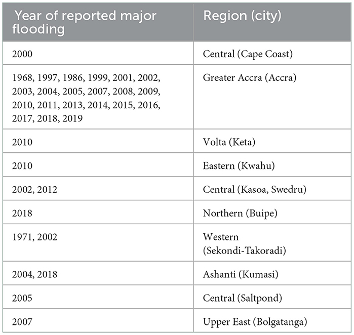
Table 3. Some major floods in Ghana (Mensah and Ahadzie, 2020).
It is common knowledge that hydraulic structures are designed based on peak flood estimates. However, such hydraulic structures sometimes burst their seams in extreme rainfall conditions. In urbanization, hard surfaces have increased in the form of pavements, thereby increasing surface runoff into the drains. Urban drains in Ghana have been overwhelmed by the poor environmental practices of the citizenry of Ghana. However, flood events have increased in magnitude, frequency, duration, and severity in Ghana due to climate change (IPCC, 2012; World Bank, 2011), thus flood risk management (FRM) regimes and sustainable adaptation approaches are urgently needed. Rain et al. (2011) and Appeaning-Addo et al. (2011) have attributed flooding occurrences to climate variability and change. The authors further related changes in rainfall and temperature patterns and coastal inundation and erosion to climate change. The changes in climatic conditions coupled with rapid urbanization modify the natural hydrology of the country resulting in heavy precipitation and increasing peak run-off discharge (Nyarko, 2002; Adank et al., 2011) leading to flush floods. The probabilistic risk profile of Ghana indicates that the country loses 200 million dollars every year due to floods and droughts. In technical terms, under the current climate and considering the frequency of floods, this average annual loss, could well be more than 200 million dollars per annum. The United Nations Office for Disaster Risk Reduction (UNISDR) Regional Office for Africa, projecting into 2050, predicted a 5-fold increase in floods. This will adversely affect the potential GDP growth of the country [United Nations Office for Disaster Risk Reduction (UNISDR) Regional Office for Africa, 2018].
5.5. Climate change and drought
Drought connotes absence of water and is defined specifically by the nature of the hazard it causes and its variation in frequency from region to region. Wilhite et al. (2007), cited by Nasirudeen et al. (2021), identified four main types of drought as meteorological, agricultural, hydrological and socio-economic. Meteorological drought is based on the degree of dryness or rainfall deficit and the length of the dry period. It is region-specific. Agricultural drought refers to conditions (reduced soil moisture) that result in adverse plant responses, which can range from reduced crop and forage yields to total crop or forage failure. Hydrological drought is based on the impact of rainfall deficits on the water supply such as stream flow, reservoir and lake levels, and ground water table decline. Socioeconomic droughts relate to the demand and supply of some economic goods with elements of other drought types and depends on the time and space processes of supply and demand. Meteorological drought occurred country-wide in the 1983, 1992, and 2001 when average annual precipitation generally fell below 900 mm (United Nations Convention to Combat Desertification, 2015). These negatively impacted agriculture nation-wide due to soil moisture deficits (agricultural drought) resulting in general crop failure. These also negatively impacted the economy of the nation, thereby affecting the supply and demand of economic goods (socioeconomic drought). Hydrological droughts occurred in Ghana in 2001, 2007, and 2013–2014, causing inflows into the Volta lake to reduce significantly resulting in low level of water in the Akosombo, Kpong, and Bui reservoirs. This consequently resulted in reduced hydropower generation (United Nations Convention to Combat Desertification, 2015).
Few studies sought to analyze drought patterns within specific basins in Ghana and most of the hydrological studies are centered around the black and white Volta basins (e.g., Kasei et al., 2010; Ndehedehe et al., 2017). According to Nasirudeen et al. (2021), these studies however do not analyze the drought profile within these basins. Nasirudeen et al. (2021), on the analysis of drought patterns in the Tano River Basin (TRB) of Ghana, suggested possible impact of climate change that could have negative implications on agricultural production and drinking water supply within the basin, since the basin solely relies on surface water for crop production and drinking water supply. Addi et al. (2021) studied meteorological drought conditions for six coastal synoptic stations (Axim, Takoradi, Saltpond, Accra, Tema, Ada) in Ghana for dry season periods of November–January, December–February, and January–March, for the period 1980–2014. They found moderate to severe drought during the dry seasons, with drought conditions becoming weaker, suggesting that the catchment areas were becoming wetter. Nyatuame and Agodzo (2017) also analyzed extreme rainfall events (drought and flood) over Tordzie watershed in the Volta Region of Ghana, which is in the coastal river basin. Tordzie is a trans-boundary basin shared between Ghana (1,865 km2) and Togo (363 km2). Drought analysis based on 3, 6, 9, and 12—month time scales showed that drought intensity was inversely proportional to its duration, meaning that as drought frequency increased its corresponding duration decreased.
5.6. Sedimentology and water-induced soil erosion
Sedimentology refers to the hydrological science of sediment erosion, flow and deposition in river channels and lakes. River channel and lake siltation have resulted in reduced channel and lake capacities to carry and hold water and may lead to floods. Sediment yield data is important in many respects, for example, in the design of hydro-turbines. Kusimi (2014) stated that “fluvial sediment yield data is an essential requirement for informed decision making on water resources development and management. However, information on the sediment load of most rivers is very rare due to the lack of financial resources to regularly undertake sediment yield studies.” Sediment studies in Ghana are few (e.g., Akrasi and Amisigo, 1993 and Akrasi, 2005; Akrasi and Ansa-Asare, 2008) and undertaken mainly by the Water Research Institute (WRI) of Ghana, covering the Volta lake, the Pra river, and some other selected rivers. Through field data collection and spatial modeling on the Pra river basin, Kusimi (2014) ascertained stakeholder's perceptions on fluvial erosion and suggested remedial measures to the problem. Braimah and Agodzo (2014), in the study of the Bontanga irrigation reservoir in northern Ghana, reported sediment deposition rates of 66.0 and 63.5 mm/y at the right and left bank intake structures, respectively, arguing that in 4 years from the time of the study, the entry to the intake structures could be blocked if remedial action was not taken.
Remedial actions for improving stream flow involve dredging of sand from the river channel and shorelines to deepen the original river channel and prevent the proliferation of both submerged and floating aquatic weeds. The benefit of harvesting of aquatic weeds and converting the harvested weeds into commercially useable forms such as organic fertilizer, animal feed, gas for domestic use or power generation, cannot be over-emphasized. Dredging of the lower Volta especially at its estuary had taken place in piecemeal approach in the past but the Volta River Authority (VRA), since 2015, has made plans to dredge the lower Volta from Akuse to its estuary at Anyanui (Volta Region) and Ada (Greater Accra Region). This again was stalled in 2020 due to the COVID pandemic.
Water-induced soil erosion is pervasive in Ghana and has threatened agricultural production due to loss of agricultural soils and soil fertility, the most affected parts being the savannah zones in northern Ghana. Lowering agricultural production through water-induced erosion could lead to socioeconomic decline (Kusimi, 2014; Tesfahunegn et al., 2021). For instance, in the savannah zone of Ghana land area of 35,172 km2 is affected by slight-to-moderate sheet erosion and 27,306 km2 by moderate-to-very severe sheet and gully erosion (Tesfahunegn et al., 2021). The water-induced erosion has been exacerbated due to climate change factors like rampant removal of vegetation cover through bushfires, deforestation, overgrazing, harvesting of firewood, and non-compliance of citizens with the environmental regulations. For example, riverine areas are to be protected through the establishment of a 50 m buffer zone on either bank of streams and rivers but removal of vegetation cover right to the edge of streams and rivers for agricultural and other purposes is very common. Adama (2003) and Peprah et al. (2016), cited by Tesfahunegn et al. (2021), stated that “despite the severe impact of soil degradation on ecology and human welfare and development, investments in sustainable soil and land management are low in countries such as Ghana.” The establishment of vegetation cover as a water conservation measure is just not appreciated.
6. Water uses
6.1. Consumptive water uses (water supply, irrigation, and livestock watering)
It is estimated that the total water withdrawal as a percentage of total renewable water resources is about 2%. Water uses in Ghana are categorized as consumptive and non-consumptive uses. The consumptive uses include water supply, irrigation and livestock watering. The non-consumptive uses include inland fisheries, water transport, hydropower generation, tourism, and environmental uses. The estimated share of consumptive water uses is 37% for water supply, 48% for irrigation and livestock watering and 15% for industrial use (Ministry of Water Resources, Works and Housing, Ghana (MWRWH), 2007). Estimated consumptive use of water in Ghana for 2020 was about 5 billion m3, working out to some 10% of the total surface water resources of 53.2 billion m3 (Table 4). There are deficits in water supply coverage and the 2004 estimates for urban and rural coverage were 55 and 51.6%, respectively. Estimated area actually under irrigation in 2020 was 100,000 ha (Ministry of Water Resources, Works and Housing, Ghana (MWRWH), 2007) but other estimates put this figure higher. For at least two cropping seasons in the year, irrigation demand could be 1,000 mm/y. This works out to about 1 billion m3 of water withdrawn for irrigated agriculture in the year, amounting to about 20% of the total water demand for water supply, irrigation and livestock. In 2020, about 2% of the total water withdrawn went into urban and rural water supply and about 8% into irrigation and animal watering. Irrigation water withdrawal accounted for about 54% in 2000 about 80% in 2020 of the total withdrawals for consumptive purposes.
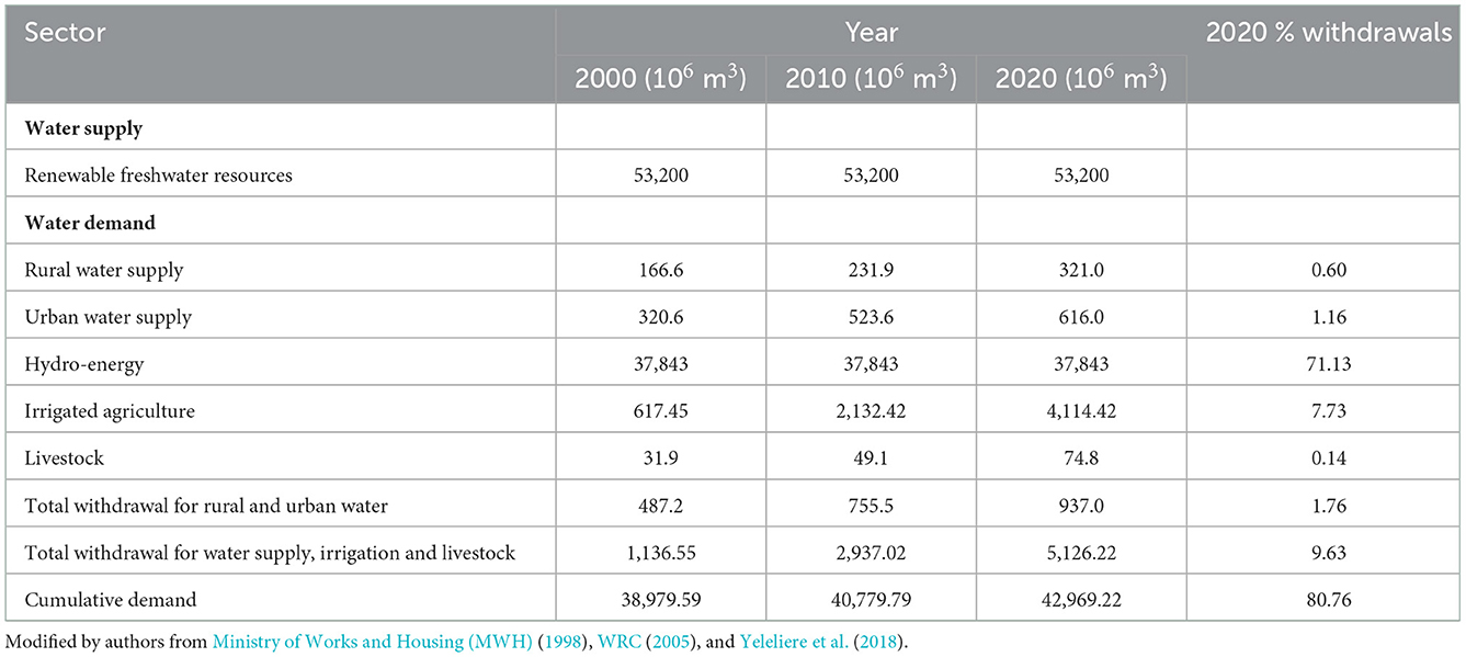
Table 4. Estimated consumptive and non-consumption use of freshwater resources from 2000 to 2020.
Per capita water resources in Ghana decreased from 2,890 m3 in 2000 to 1,760 m3 in 2020, working out averagely to about 56.5 m3/y over the period, even though this may not be a linear decrease. At an assumed average per capita consumption of water of 50 l/p/d, estimated daily water demand for the 2021 population of 31 million people stands at about 566 million m3/y, amounting to about 1% of the renewable freshwater resources. As the capita freshwater consumption increases, the demand will correspondingly increase in the face of population growth. Current water supply systems are overstretched and it is further estimated that about US $ 240 million is required per year as capital expenditure in urban and rural water supply. According to UPgro African Groundwater Country Study (2020), “over 95% of groundwater use in Ghana is for domestic water supply, mostly in rural areas and small towns. Overall, around 41% of households in Ghana depend on groundwater for their water supply—this is generally much higher in rural areas (59%) than urban areas (16%). However, there are some urban areas, in the Upper East and Upper West regions, where 80% of the urban population depend on groundwater for their primary water supply. Less than 5% of groundwater in Ghana is used for irrigation and watering of livestock and poultry. Industrial use of groundwater in Ghana accounts for < 1% of the total groundwater use. This includes large-scale commercial bottled water companies in the south of the country.”
Irrigation from a policy perspective in Ghana is classified as formal, informal, and commercial but its potential and structure are not well-understood. Formal irrigation is developed and managed by government through the Ghana Irrigation Development Authority (GIDA). Informal irrigation in Ghana involves the individual and private-initiated schemes. The commercial schemes include export-led schemes that use the high-end irrigation systems to produce fruits, vegetables, and the ornamentals for export. Ghana's irrigation potential, including valley bottoms and floodplains, is put at between 0.36 and 2.9 million ha (Agodzo and Bobobee, 1994) but as mentioned earlier, Ministry of Water Resources, Works and Housing, Ghana (MWRWH) (2007) put actual area under all forms of irrigation at about 100,000 ha. This is said to account for an estimated 66.4% of the total water withdrawal for water supply, irrigation, and animal watering. The formal schemes constitute between 22 and 50 projects dotted around the country and they include the bilateral and multilateral project funded schemes.
For Ghana, nearly 9.44 million animals (cattle, sheep and goats) in 2010 would have consumed up to 22 million m3 of water. This should be equivalent to the maximum safe storage of the Bontanga reservoir in the Northern Region of Ghana. Animal production requires provision of adequate water at vantage locations for the animals and this is necessary for a good performance of the animal industry in Ghana and elsewhere. Quite often, when it comes to the construction of dams, consideration of such facilities for animals comes as after—thoughts. Direct interventions for animal watering facilities in Ghana are few and incomprehensive. The huge potentials of the animal industry cannot be achieved without adequate provision of water, where dams provide some options (Agodzo et al., 2014).
6.2. Non-consumptive uses
6.2.1. Inland fisheries
The Volta lake offers the most important inland fishing source and one could count as many as 32 landing sites which often also serve as marketing centers. Among these are Kwamekrom, Tepa Abotoase, Dzemeni, Dambai, Akateng, and Kpando Torkor. It is estimated that fish from the Volta Lake contributes to 16% of total catch in Ghana. The coastal lagoons and the several surface waters, in addition to fish farming, also offer additional sources of fish. Denyoh (1971), cited by Freeman (1974), reported that when Volta Lake started to form in 1964, it changed the inland fishing landscape, arguing that before the construction of the Volta Dam at Akosombo and its subsequent formation of the lake, there were not more than 2,000 fishermen operating in the Volta basin and they were mainly nomadic fishermen. The post lake formation fishing activities increased and fishing village surveys conducted in 1968 and 1969 revealed at least 10,000 fishing villages with 20,000 fishermen scattered along the lake shore. The estimated number of fishing canoes was between 11,000 and 14,000 and estimated fish catch in 1969 as between 50,000 and 70,000 MT/y, compared with about 10,000 MT/y from the previous riverine fishery. The 2014–2017 Sector Medium Term Development Plan (SMTDP) of the Ministry of Fisheries and Aquaculture Development (MOFAD) targeted fish catch of 100,000 MT/y by 2017 (MOFAD/Fisheries Commission, 2014) but such a projection is well below the actual fish catch.
6.2.2. Inland water transport
Water transport is common in places inaccessible by road, using small canoes but the notable inland water transport facilities are run by the Volta Lake Transport Company (VTLC) which was officially incorporated in 1970 to operate river transportation for passengers, bulk haulage of petroleum products and cross-lake ferry services along the Volta Lake. It conveys passengers and bulk goods between Akosombo (Eastern Region), in the south and Buipe (Savannah Region) in the north, additional to other landing sites in the Brong Ahafo, Volta and Oti Regions.
According to Solomon et al. (2021), operations of VLTC involve the use of flat-bottom river ferries. Goods transported from the north to Akosombo are further transported by road to Accra and Tema and distributed to other business centers. Also, passenger ferries and water-buses are used to transport human traffic and automobiles from one town to the next across the Volta river and this is referred to as “ferry-crossing.” The company's current operational stations are Yeji, Dambai, Kete Krachi, Adawso, and Akosombo. VLTC has a ferry fleet of nineteen (19) made up of passenger vessels/water buses, cargo ferries and barges and carries the average of 647,000 passengers and 57,000 cars per year, on all its ferries (NASA, 2018; Solomon et al., 2021). According to Inros Lackner AG (ILAG, 2014), cited by Solomon et al. (2021), there are 500 informal boats operating on the Volta Lake. These are wooden boats powered by motors. They also carry passengers, fishes, farm produce, and charcoal amounting to 112,000 MT annually. The estimated cargo carried every year on the lake is 255,000 MT. The larger part is carried by VLTC and is composed mostly of oil products and cement (131,000 MT); other merchandise includes yam (6,000 MT) and general cargo (6,000 MT). Inland waterway transport is largely recognized as the safest, cleanest and most energy efficient among all land-based modes of transport, yet the Volta lake has recorded its fair share of accidents in the past due to poor safely measures.
6.2.3. Hydropower generation
Hydropower accounts for about 40% of total power installed capacity from 3 hydropower stations: Akosombo (1,020 MW), Kpong (160 MW), and Bui (404 MW). The Akosombo dam, completed in 1964, created a man-made lake with a surface area of about 8,300 km2. About 71% of the renewable surface water resources go into hydropower generation (Ministry of Water Resources Works and Housing (MWRWH), 2012).
6.2.4. Tourism
Tourist attractions are offered by the 550 km Ghana's shoreline that has about 90 lagoons, additional to estuaries and associated floodplains (Yankson and Obodai, 1999; Okyere et al., 2012) offering some exquisite hotels and opportunities for water sports and bird watching, despite the fact that part of the shoreline is threatened by sea erosion. The Volta Lake, the lower Volta river at Sogakope and Ada, and some other inland waters (e.g., Lake Bosumtwi) offer spectacular views and opportunities for boat cruises and water sports. Waterfalls in Ghana serve as tourist attraction sites. There are more than 10 of them, the majority of which are located in the Eastern and Volta Regions of Ghana. The landforms in these two regions provide mountain ranges (Mampong—Akwapim—Togo ranges) that are suitable for such waterfalls. The notable water falls are the Boti (Eastern Region), Tagbo (Volta Region), Fuller (Bono East Region), Kintampo (Bono East Region), and Wli (Volta Region) waterfalls. The Wli waterfall is the highest in Ghana and West Africa, cascading through a height of about 80 m.
6.3. Wastewater
At the turn of the twenty-first century, data on commercial and industrial wastewater production were virtually non-existent. Knowledge on safe wastewater use in agriculture was also virtually non-existent and funding for research into low-cost treatment of wastewater was unavailable. Wastewater treatment, especially, low-cost technologies were lacking in Ghana. Also, at the time, wastewater studies in Ghana were few (e.g., Anku et al., 1998; International Food Policy Research Institute, 1998; Cornish et al., 1999; Armar-Klemansu and Maxwell, 2000; Agodzo et al., 2003) and concentrated on the economic activities wastewater irrigation generated in urban and peri-urban Ghana. As time went on concerns began to grow on the risks associated with the use of such contaminated waters for the growth of vegetable crops in the urban and peri-urban areas of Ghana. The International Water Management Institute (IWMI), largely led the research component on wastewater use for urban and peri-urban agriculture in Ghana with notable research works as Obuobie et al. (2006), Murray and Drechsel (2011), and Drechsel and Keraita (2014). About 38% of the population dispose of liquid waste by throwing them in the streets or outside their houses, 21% dispose of liquid waste directly into gutters, 35% in the compound, and about 1% in other places (Obuobie et al., 2006). Agodzo et al. (2003) did a study on wastewater use for agriculture and made some projections. They estimated 2020 wastewater generation as about 760 million m3 per annum, including stormwater. They stated that if only 10% of the wastewater generated was used for agriculture, this could irrigate about 12,700 ha of urban Ghana per annum, generating employment for about 25,440 farmers and farm income of US $17.8 million per annum. Available epidemiological studies on urban and peri-urban agriculture focused on the health risks and the safe use of wastewater, some of which are subsequently discussed.
Kwabla (2017) assessed the willingness to grow crops with treated wastewater and consume same and found that between 92.6 and 95% of people in Ashaiman and students in the University of Ghana, respectively, were willing to do so. The physico-chemical and microbiological qualities of wastewater studied were deemed to be within the acceptable WHO standards. Adu-Ofori (2019) evaluated the performance of domestic sewage ponds in Accra sewage treatment plant at Legon, in order to determine the suitability of the final effluent for irrigation and the quality of sludge for manure. He found that even though removal efficiency of E. coli was high, it could not meet the Ghana EPA acceptable standard but recommended the sludge as manure for soil fertility improvement. Awuah et al. (2014) assessed wastewater treatment system with flow rates of 720 and 870 m3/d. They concluded that even though the feacal coliform and heavy metal levels were low in the wastewater, they could still be harmful from the point of view their use for irrigation of vegetable crops and discharge into the natural water bodies. Pesewu et al. (2017) evaluated the bacteriological water quality of the wastewater used for irrigation in the vegetable farms at Korle-Bu Teaching Hospital (KBTH), Accra Metropolis, Ghana and concluded that mean total bacterial colony count far exceeded WHO recommended levels for unrestricted irrigation of crops likely to be eaten raw. Six predominant bacteria were isolated in the study, recommending that crop growers should use treated wastewater for farming while processors and consumers should minimize contamination risks before consumption. Abass et al. (2016) and Silverman et al. (2013) also did similar studies with similar health risk conclusions. Agyemang et al. (2013) designed a sequential batch reactor wastewater treatment plant that had removal efficiencies of key parameters such as conductivity, BOD, COD, and ammonia of between 50 and 100%; though performance for total coliforms, TSS and turbidity were unsatisfactory. They recommended the introduction of a slow sand filter to improve the removal efficiency and disinfection before final effluent discharge into the Atonsu stream.
Murray and Drechsel (2011) studied the reasons for the failure of liquid waste management facilities, reporting that with about 70 decentralized systems throughout Ghana, <10 (14%) are operating effectively. Comparing the successful and the unsuccessful facilities, the research revealed important differences in the operation and maintenance (O&M) strategies, financing schemes and incentive structures in the successful vs. unsuccessful facilities. They agreed that this may not be unique to Ghana and recommended effective planning and funding to improve sanitation services that can positively impact on environmental and public health. Biodigester wastewater treatment systems are now available commercially with the increasing housing estates being developed in the cities.
7. Existing water legislation and climate policy
7.1. Water legislation and water sector institutions
In the legal context, water governance issues are handled by various institutions created by Acts of Parliament as detailed in Table 5. Their water-related mandates, objects and/or functions are also shown. Under customary law, water is considered a common good and vested in stools, communities, and families and this does not create private ownership over such a resource (Ofori Boateng, 1977). Rules evolved under customary law, governing domestic uses, animal watering, and fishing. This leads to certain management choices, an example of which is determining whether an upstream or downstream part of a river could be used for drinking, washing, and animal watering. Fishing days are also determined and some riverine forest are also protected from encroachment. The sacredness of water and its customary use are also shrouded in religious beliefs.
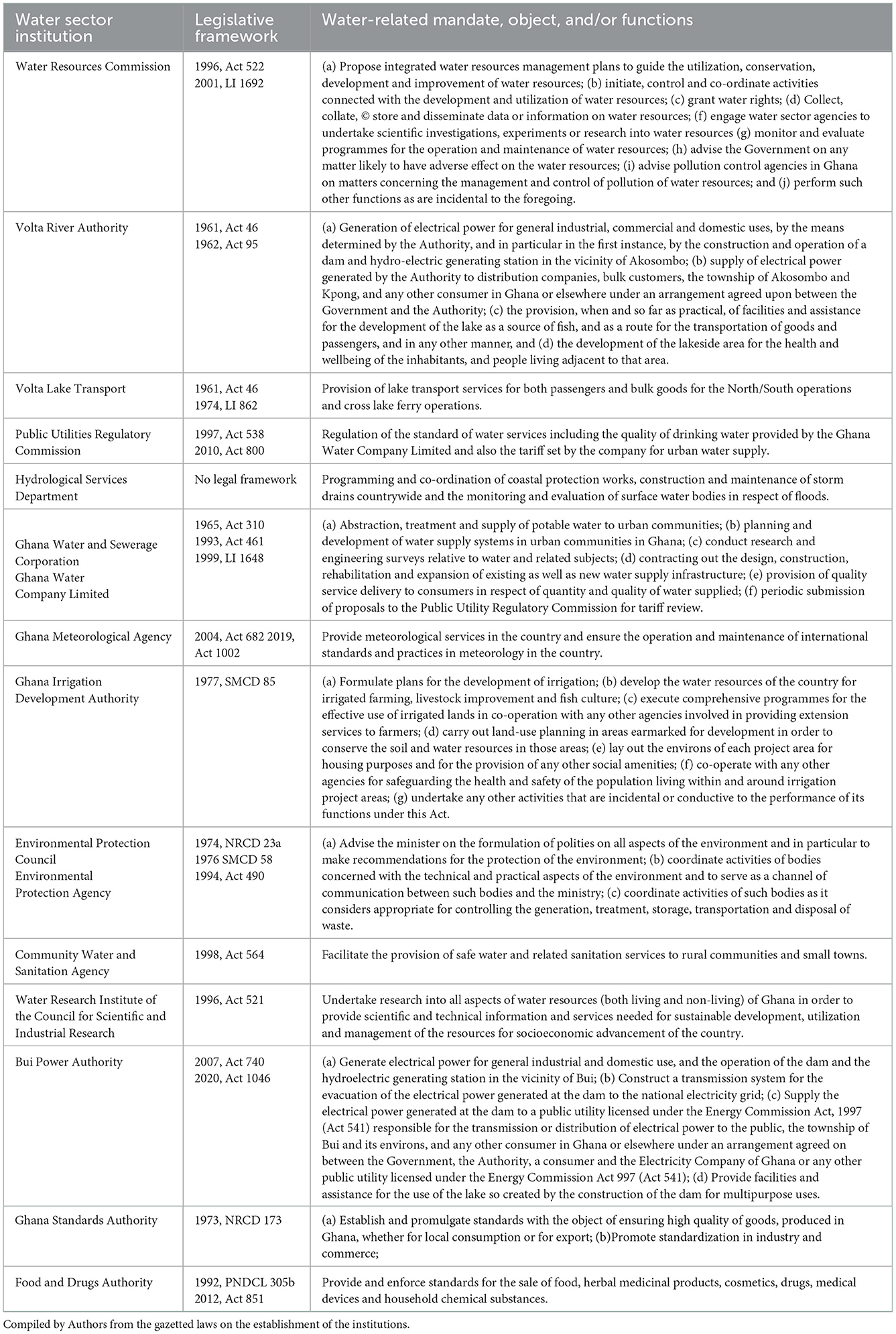
Table 5. Water sector institutions, their legislative frameworks and water-related mandate, object, and/or functions.
The Water Resources Commission (WRC) is the umbrella institution mandated to regulate all water issues, particularly water withdrawal issues, since all water is considered vested in the state. Some of the institutions include the Ghana Meteorological Services (GMet), Ghana Water Company Limited (GWCL), Ghana Irrigation Development Authority (GIDA), Environmental Protection Agency (EPA), Community Water and Sanitation Agency (CWSA), Volta Lake Transport Company (VLTC), Volta River Authority, Bui Power Authority, Public Utilities Regulatory Commission (PURC). The Ghana Standards Authority (GSA) ensures high quality of goods imported and exported and promotes standardization in industry and commerce, including the water industry. The Food and Drugs Authority (FDA) operates in the context of public health and enforces standards for the sale of food, herbal medicinal products, cosmetics, drugs, medical devices, and household chemical substances. Food here implies food, beverages and drinking water. According to Ministry of Water Resources, Works and Housing, Ghana (MWRWH) (2007), the Hydrological Services Department (HSD) of the Ministry of Water Resources, Works and Housing, the Water Research Institute (WRI) of the Council for Scientific and Industrial Research (CSIR), and the Ghana Meteorological Agency (GMet) constitute what is referred to as the Water Resources Information Services (WRIS) institutions. They provide data and other water resources related information and services to support planning and decision making. The universities also provide training and undertake water research. The work of the Forestry Commission (1999, Act 571) and Minerals Commission (1993, Act 450) have a lot of bearing on the conservation and utilization of water resources in Ghana. The interdependence of water and forestry in terms of water conservation is well-known, requiring the maintenance of tree cover, particularly at the sources of streams and rivers.
7.2. Climate-related policy issues on water
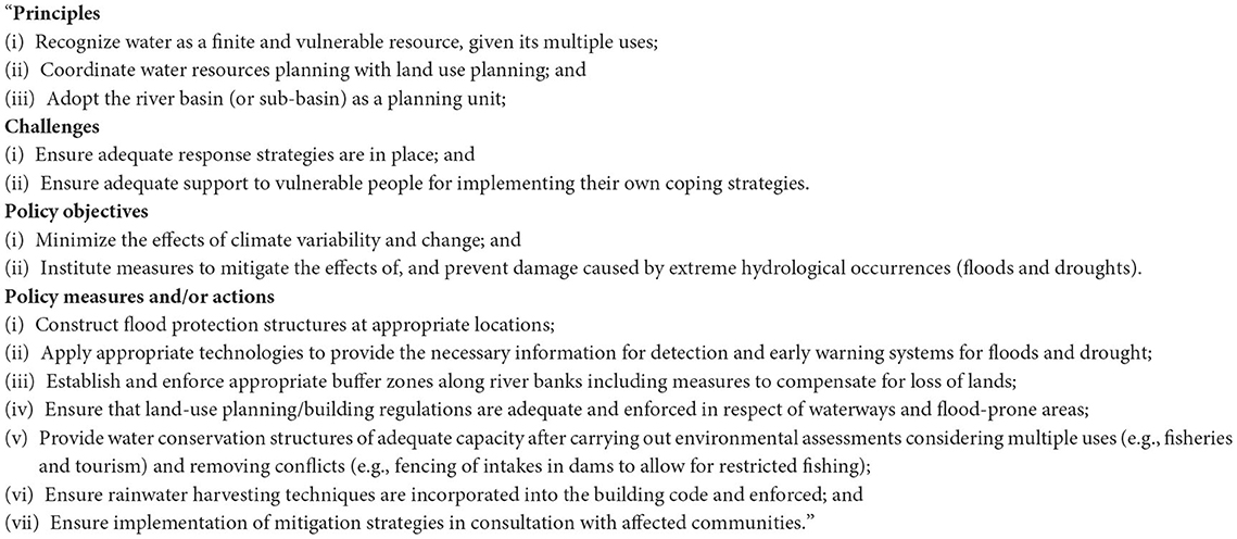
Ghana's climate-related policy issues on water works on the principle of recognizing water as a common good; ensuring adequate mitigating strategies be put in place in support of vulnerable groups; and minimizing effects of climate variability and change in the context of adequate land use planning and enforcement in respect of waterways and flood-prone areas. Details on the principles, challenges, policy objectives, and actions are reproduced in Box 1.
Box 1. Climate—related policy issues on water in Ghana (Ministry of Water Resources, Works and Housing, Ghana (MWRWH), 2007).
8. Implication of study and way forward
The significant impact of climate change affecting hydrometeorological parameters directly or indirectly threatens the services provided by water resources and water sector in Ghana (IPCC, 2012). According to Obuobie et al. (2012b), the White Volta basin will be water scarce (50% reduction in estimated water resource from reference) between 2036 and 2065 and the Pra river basin will be at absolute water scarcity in same period (46% reduction) without climate change impact. Amisigo et al. (2015) projected catchment runoff between 2011 and 2050 to reduce by 8.95 and 25.9% in the Volta and Pra river basins, respectively, under the Ghana dry climate scenario and increase by 2.28 and 60.9% in same basins under the Ghana Wet climate scenario, respectively. Bessah et al. (2020b) also projected 35% reduction in seasonal water yield from ensemble of five climate models in the Pra river basin for the period 2020–2049. Densu river basin is projected to reduce water resources by 58.3% between 2051 and 2080 under climate change (Oti et al., 2020). These projections could affect groundwater recharge negatively thereby reducing groundwater resources. Mean basin runoff across 28 basins under Ghana dry climate scenario is projected to reduce by 17.14% and under the Ghana wet climate scenario to increase by 34.25% in the period 2011–2050 (Amisigo et al., 2015). Atiah et al. (2020) reported decreasing trend of wet extreme indices over the Volta basin while Oguntunde et al. (2020) projected an increasing magnitude and frequency of severe drought over the Volta Basin under four (4) global warming scenarios.
Some implications are as follows:
a) Rainfall studies in Ghana have not been conclusive on trends. Some reported increasing trends and others decreasing trends over the years. More frequent extreme events have been reported suggesting that human behavior is exacerbating these events globally. Accra, for example, has been flooded almost every year in the past 20 years or more and that trend seems to be continuing. The Accra floods have not only been attributed to extreme rainfall events but also poor city planning, increased paved surfaces, removal of natural vegetation, inadequate drainage systems, and negative human behavior. Forest cover loss and artisanal mining activities in some of the river basins, particularly in the Eastern and Western Regions of Ghana, have not only led to the drying up of some of the streams but also caused excessive erosion and siltation and pollution of the river systems. The political will appears not be there to tackle these issues head-on.
b) Drought studies are limited but the least rainfall recorded in Ghana in recent history was in 1983. Evapotranspiration studies are almost non-existent but changing climate suggests higher water deficits across the country due to higher evaporative demand. The cropping calendar has been changing and agricultural activity has been impacted in different ways at different locations across the country.
c) Sediment studies in the lower Volta suggested that settlements on the banks of the river should consider relocating on higher ground due to possible future floods exacerbated by the siltation of the river channel.
d) Per capita water resources in Ghana decreased from 2,890 m3 in 2000 to 1,760 m3 in 2020, working out averagely to about 56.5 m3/y over the period, even though this may not be a linear decrease. As the population increases, this will continue to decrease. However, demand for water for agriculture, domestic and industrial uses have increased. This means that one cannot continue with business as usual in water resources management. Ghana's climate-related policy issues on water works on the principle of recognizing water as a common good; ensuring adequate mitigating strategies be put in place in support of vulnerable groups; and minimizing effects of climate variability and change in the context of adequate land use planning and enforcement in respect of waterways and flood-prone areas. On paper, it looks very good but, in implementation, it does not since such regulating agency as the WRC is not even well-equipped to carry out its mandate.
e) Hydropower generation has been affected in the past due to decline in reservoir water levels attributed partly to declining rainfall. Rural water supply comes mainly from groundwater sources, but the full picture is not clear regarding groundwater availability. Drying up of wells are widely reported at local levels, probably due partly to low recharge and high evaporative demand.
Due to climate change, the implementation of integrated water resources management (WRM) should be considered more seriously. This should include strict enforcement of water conservation laws, especially along buffer zones. In view of better land use planning, urban greening instead of pavement construction should be encouraged in order to increase infiltration capacity and curtail runoff volume which would eventually reduce flooding. The IWRM intervention should also consider increased financial resource allocation to awareness creation and education, and relief services for the vulnerable during climate change disasters.
9. Conclusion
An extensive narrative review approach is adopted to present existing information on the consumptive and non-consumptive uses of water in Ghana and their related issues, such as floods and droughts, climate and the environment. Several water issues have been put in one volume, enabling the reader to appreciate the full picture of water related issues.
Author contributions
SA conceptualized the study, designed and analyzed the literature, wrote the manuscript, and revised it. EB and MN reviewed and edited the manuscript. All authors contributed to the article and approved the submitted version.
Acknowledgments
We appreciate the open source policy for access to literature on the water resources, consumptive and non-consumptive uses, and the climate -related water issues in Ghana. We also thank the editors and reviewers for improving the quality of the paper through review and editorial services.
Conflict of interest
The authors declare that the research was conducted in the absence of any commercial or financial relationships that could be construed as a potential conflict of interest.
Publisher's note
All claims expressed in this article are solely those of the authors and do not necessarily represent those of their affiliated organizations, or those of the publisher, the editors and the reviewers. Any product that may be evaluated in this article, or claim that may be made by its manufacturer, is not guaranteed or endorsed by the publisher.
References
Abass, K., Ganle, J. K., and Adaborna, E. (2016). Coliform contamination of peri-urban grown vegetables and potential public health risks: evidence from Kumasi, Ghana. J. Commun. Health 41, 392–397. doi: 10.1007/s10900-015-0109-y
Acheampong, P. K. (1986). Evaluation of potential evapotranspiration methods for Ghana. GeoJournal 12, 409–415. doi: 10.1007/BF00262364
Adama, A. I. (2003). The effect of different tillage practices on soil erosion, water conservation and yield of maize in the semi-deciduous forest zone of Ghana (M.Sc. Thesis). Department of Crop and Soil Sciences, Kwame Nkrumah University of Science and Technology, Kumasi, Ghana.
Adank, M., Darteh, B., Moriarty, P., Osei-Tutu, H., Asaan, D., and Rooijen, D. V. (2011). Towards Integrated Urban Water Management in the Greater Accra Metropolitan Area, Current Status and Strategic Directions for the future. SWITCH/RCN: Accra.
Addi, M., Asare, K., Fosuhene, S. K., Ansah-Narh, T., Aidoo, K., and Botchway, C. G. (2021). Impact of large-scale climate indices on meteorological drought of coastal Ghana. Adv. Meteorol. doi: 10.1155/2021/8899645
Adu Kumi, J. M., and Apraku, A. (2015). Threats to the conservation of wetlands in Ghana: the case of songor ramsar site. J. Sci. Res. Rep. 6, 13–25. doi: 10.9734/JSRR/2015/13906
Adu-Ofori, E. (2019). Assessment of suitability of sludge and wastewater quality in waste stabilisation pond system in Accra-Ghana for agriculture purposes (MPhil Thesis). Institute for Environment and Sanitation Studies (IESS), University of Ghana. Available online at: http://ugspace.ug.edu.gh/handle/123456789/35908
Affum, A. O., Osae, S. D., Nyarko, B. J. B., Afful, S., Fianko, J. R., Akiti, T. T., et al. (2015). Total coliforms, arsenic and cadmium exposure through drinking water in the Western Region of Ghana: application of multivariate statistical technique to groundwater quality. Environ. Monitor. Assess. 187, 1–23. doi: 10.1007/s10661-014-4167-x
Agodzo, S. K., and Bobobee, E. Y. H. (1994). “Policy issues of irrigation in Ghana: 1960 – 1990,” in Proceedings of CIGR World Congress on Agricultural Engineering, Vol. 1 (Milan), 335–343.
Agodzo, S. K., Huibers, F. P., Chenini, F., van Lier, J. B., and Duran, A. (2003). “Use of wastewater in irrigated agriculture,” in Country studies from Bolivia, Ghana and Tunisia, Volume 2: Ghana (Wageningen: WUR; W4F-Wastewater). Available online at: www.dou.wau.nl/iwe
Agodzo, S. K., Obuobie, E., and Braimah, C. A. (2014). The effects of irrigation dams on water supply in Ghana. IOSR J. Eng. 4, 48–53. doi: 10.9790/3021-04534853
Agyemang, O. A., Esi, A., Lawrence, D., Richard, A., and Gabriel, O. (2013). Water quality assessment of a wastewater treatment plant in a Ghanaian Beverage Industry. Int. J. Water Resourc. Environ. Eng. 5, 272–279.
Aidoo, K., Klutse, N. A. B., Asare, K., Botchway, C. G., and Fosuhene, S. (2021). Mapping evapotranspiration of agricultural areas in Ghana. Sci. World J. doi: 10.1155/2021/8878631
Akrasi, S. A. (2005). The assessment of suspended sediment inputs to Volta Lake. Lakes Reservoirs Res. Manage. 10, 179–186. doi: 10.1111/j.1440-1770.2005.00272.x
Akrasi, S. A., and Amisigo, B. A. (1993). Sediment Loads of Some Rivers in Ghana. Accra: Water Research Institute. Technical Report #34.
Akrasi, S. A., and Ansa-Asare, O. D. (2008). Assessing sediment and nutrient transport in the Pra basin of Ghana. West Afr. J. Appl. Ecol. 13, 61–73. doi: 10.4314/wajae.v13i1.40583
Akyeampong, E. K. (2001). Between the Sea and the Lagoon: An Eco Social History of the Anlo of South-eastern Ghana. Athens, OH: Ohio University Press. p. 7.
Amekudzi, L., Yamba, E., Preko, K., Asare, E., Aryee, J., Baidu, M., et al. (2015). Variabilities in rainfall onset, cessation and length of rainy season for the various agro-ecological zones of Ghana. Climate 3, 416–434. doi: 10.3390/cli3020416
Amisigo, B. A., McCluskey, A., and Swanson, R. (2015). Modeling impact of climate change on water resources and agriculture demand in the volta basin and other basin systems in Ghana. Sustainability 7, 6957–6975. doi: 10.3390/su7066957
Amoako, C., and Inkoom, D. K. B. (2018). The production of flood vulnerability in Accra, Ghana: re-thinking flooding and informal urbanisation. Urban Stud. 55, 2903–2922. doi: 10.1177/0042098016686526
Ampadu, B. (2008). Simulating rainfall and river flow dynamics in Ghana (An Unpublished PhD Thesis). Lancaster University, Lancaster, United Kingdom.
Ampadu, B., Sackey, I., and Cudjoe, E. (2019). Rainfall distribution in the Upper East Region of Ghana, 1976 - 2016. Ghana J. Sci. Technol. Dev. 6. doi: 10.47881/168.967x
Anim-Gyampo, M., Anornu, G. K., Agodzo, S. K., and Appiah-Adjei, E. K. (2018). Groundwater risk assessment of shallow aquifers within the Atankwidi basin of Northeastern Ghana. Earth Syst. Environ. 3, 59–72. doi: 10.1016/j.gsd.2019.100217
Anku, S., Doe, B., and Tetteh, D. (1998). “Environmental assessment of urban agriculture in Accra,” in Urban Agriculture in the Greater Accra Metropolitan Area, eds M. Armar-Klemansu and D. Maxwell (Stockholm Environmental Institute).
Ansa-Asare, O. D., and Gordon, C. (2012). Water quality assessment of Densu, Birim and Ayensu rivers in the Okyeman area. West Afr. J. Appl. Ecol. 20, 53–64.
Ansah, S. O., Ahiataku, M. A., Yorke, C. K., Otu-Larbi, F., Bashiru, Y., Lamptey, P. N. L., et al. (2020). Meteorological analysis of floods in Ghana. Adv. Meteorol. doi: 10.1155/2020/4230627
Appeaning-Addo, K., Larbi, L., Amisigo, B., and Ofori-Danso, P. K. (2011). Impacts of coastal inundation due to climate change in a cluster of urban coastal communities in Ghana, West Africa. Remote Sens. 3, 2029–2050. doi: 10.3390/rs3092029
Armar-Klemansu, M., and Maxwell, D. (2000). “Accra: urban agriculture as an asset, supplementing income and diets,” in Growing Cities, Growing Food, eds N. Baker, M. Dubbeling, S. Guendel, U. Sabel-Koschella, and H. de Zeeuw [German Foundation for International Development (DSE)]. p. 183–205.
Asamoah-Boateng, E. K. (2009). Physico-chemical and microbiological quality of surface waters within the Newmont Ghana Gold Mining concession areas (MSc Thesis). Department of Theoretical and Applied Biology, Kwame Nkrumah University of Science and Technology, Kumasi, Ghana.
Asante, F. A., and Amuakwa-Mensah, F. (2015). Climate change and variability in Ghana: stocktaking. Climate 3, 78–101. doi: 10.3390/cli3010078
Asante, F. G. (2012). Physico-chemical quality of water sources in the gold mining areas of Bibiani (MSc Thesis). Department of Theoretical and Applied Biology, Kwame Nkrumah University of Science and Technology, Kumasi, Ghana.
Asumadu-Sarkodie, S., Owusu Phebe, A., and Rufangura, P. (2015). Impact analysis of flood in Accra, Ghana. Adv. Appl. Sci. Res. 6, 53–78.
Atiah, W. A., Mengistu Tsidu, G., Amekudzi, L. K., and Yorke, C. (2020). Trends and interannual variability of extreme rainfall indices over Ghana, West Africa. Theor. Appl. Climatol. 140, 1393–1407. doi: 10.1007/s00704-020-03114-6
Awuah, E., Amankwaah-Kuffour, R., Gyasi, S. F., Lubberding, H. J., and Gijzen, H. J. (2014). Characterization and management of domestic wastewater in two suburbs of Kumasi, Ghana. Res. J. Environ. Sci. 8, 318–330. doi: 10.3923/rjes.2014.318.330
Bessah, E., Amponsah, W., Owusu Ansah, S., Afrifa, A., Yahaya, B., Wemegah, C. S., et al. (2022). Climatic zoning of Ghana using selected meteorological variables for the period 1976 - 2018. Meteorol. Appl. 29, e2049. doi: 10.1002/met.2049
Bessah, E., Boakye, E. A., Agodzo, S. K., Nyadzi, E., Larbi, I., and Awotwi, A. (2021a). Changes in seasonal rainfall in the 21st-century over Ghana and its implication for agriculture productivity. Environ. Dev. Sustain. 23, 12342–12365. doi: 10.1007/s10668-020-01171-5
Bessah, E., Raji, A. O., Taiwo, O. J., Agodzo, S. K., and Ololade, O. O. (2020a). The impact of varying spatial resolution of climate models on future rainfall simulations in the Pra River Basin (Ghana). J. Water Climate Change 11, 1263–1283. doi: 10.2166/wcc.2019.258
Bessah, E., Raji, A. O., Taiwo, O. J., Agodzo, S. K., Ololade, O. O., and Strapasson, A. (2020b). Hydrological impacts of climate and land use changes: the paradox of regional and local climate effect in the Pra River Basin of Ghana. J. Hydrol. Regional Stud. 27, 100654. doi: 10.1016/j.ejrh.2019.100654
Bessah, E., Raji, A. O., Taiwo, O. J., Agodzo, S. K., Ololade, O. O., Strapasson, A., et al. (2021b). Assessment of surface waters and pollution impacts in Southern Ghana. Hydrol. Res. 52, 1423–1435. doi: 10.2166/nh.2021.051
Bessah, E., Raji, A. O., Taiwo, O. J., Agodzo, S. K., Ololade, O. O., Strapasson, A., et al. (2021c). Gender-based variations in the perception of climate change impact, vulnerability and adaptation strategies in the Pra River Basin. Int. J. Climate Change Strategies Manage. 13, 435–462. doi: 10.1108/IJCCSM-02-2020-0018
Biswas, E. R. I. (1967). Bacterial Ecology of Volta Lake at Ajena. Volta Basin Research Project Technical Report X18. Accra: University of Ghana. p. 12.
Braimah, C. A., and Agodzo, S. (2014). Challenges to efficient and effective irrigation water management in Ghana - the case of Bontanga irrigation project. IOSR J. Eng. 4, 34–41. doi: 10.9790/3021-04423441
Brown, C. (2010). The end of reliability. J. Water Res. Plan. Manag. 136, 143–145. doi: 10.1061/(ASCE)WR.1943-5452.65
Cobbina, S. J., Anyidoho, L. Y., Nyame, F., and Hodgson, I. O. A. (2010). Water quality status of dugouts from five districts in Northern Ghana: implications for sustainable water resources management in a water. doi: 10.1007/s10661-009-1059-6
Codjoe, S. N. A., Appeaning Addo, K., Addoquaye Tagoe, C., Nyarko, B. K., Martey, F., Nelson, W. A., et al. (2020). “The Volta Delta, Ghana: challenges in an African setting,” in Deltas in the Anthropocene,. eds R. Nicholls, W. Adger, and C. Hutton, S. Hanson (Cham: Palgrave Macmillan), 79–102.
Corcoron, E., Ravilious, C., and Skuja, M. (2007). Mangroves of Western and Central Africa. Report produced for UNEP-DEPI under the UNEP Biodiversity Related Projects in Africa. UNEP World Conservation Monitoring Centre (UNEP-WCMC), Nairobi.
Cornish, G. A., Mensah, E., and Ghesquine, P. (1999). Water Quality and Peri-Urban Irrigation. An Assessment of Surface Water Quality for Irrigation and Its Implications for Human Health in Peri-Uban Zone of Kumasi, Ghana. KAR Project R7132 Report OD/TN95. Wallingford.
Denyoh, F. M. K. (1971). Fishery development, Volta Lake, Ghana. Paper presented at the Man-Made Lakes Symposium (Knoxville, TN).
Drechsel, P., and Keraita, B, . (eds) (2014). Irrigated Urban Vegetable Production in Ghana: Characteristics, Benefits and Risk Mitigation. Colombo: International Water Management Institute (IWMI). p. 240.
Dwamena, H. A., Tawiah, K., and Akuoko Kodua, S. A. (2022). The effect of rainfall, temperature, and relative humidity on the yield of Cassava, Yam, and Maize in the Ashanti Region of Ghana. Int. J. Agronomy. 2022, 12. doi: 10.1155/2022/9077383
Freeman, P. H. (1974). Environmental Aspects of a Large Tropical Reservoir. A Case Study of the Volta Lake, Ghana. Washington, DC: Office of International and Environmental Programs, Smithsonian Institution. p. 356.
Frick-Trzebitzky, F., and Bruns, A. (2019). Disparities in the implementation gap: adaptation to flood risk in the Densu Delta, Accra, Ghana. J. Environ. Policy Plan 21, 577–592. doi: 10.1080/1523908X.2017.1343136
Frimpong, K., Oosthuizen, J. D., and Van Etten, E. J. (2014). Recent trends in temperature and relative humidity in Bawku East, Northern Ghana. J. Geograph. Geol. 6, 69–81. doi: 10.5539/jgg.v6n2p69
Galloway, G. E. (2011). If stationarity is dead, what do we do now? J. Am. Water Resour. Assoc. 47, 563–570. doi: 10.1111/j.1752-1688.2011.00550.x
Ghansah, B., Forkuo, E. K., Frimpong Osei, E., Appoh, R. K., Asare, M. Y., and Browne Kluste, A. N. (2018). Mapping the spatial distribution of small reservoirs in the White Volta Sub-basin of Ghana. Remote Sens. Appl. Soc. Environ. 9, 107–115. doi: 10.1016/j.rsase.2017.12.003
Goski, B. N. W. (1999). The quality of water of the Weija Dam and the Densu River (MPhil Thesis). Department of Nutrition and Food Science, University of Ghana, Legon, Available online at: http://ugspace.ug.edu.gh
Hirsch, R. M. (2011). A perspective on nonstationarity and water management. J. Am. Water Resour. Assoc. 47, 436–446. doi: 10.1111/j.1752-1688.2011.00539.x
ILAG. (2014). Consultancy Services for Preparation of a Medium-Term Master Plan for Transportation on the Volta Lake and its Surrounding Region.
Incoom, A. B. M., Adjei, K. A., Odai, S. N., Akpoti, K., and Siabi, E. K. (2022). Impacts of climate change on crop and irrigation water requirement in the Savannah regions of Ghana. J. Water Climate Change 13, 3338–3356. doi: 10.2166/wcc.2022.129
International Food Policy Research Institute (1998). Accra Urban Food and Nutrition Study. Final Report to WHO. IFPRI, Washington, DC.
IPCC (2012). “Managing the risks of extreme events and disasters to advance climate change adaptation,” in A Special Report of Working Groups I and II of the Intergovernmental Panel on Climate Change, eds C. B. Field, V. Barros, T. F. Stocker, D. Qin, D. J. Dokken, K. L. Ebi, et al. (Cambridge; New York, NY: Cambridge University Press), 582.
Karikari, A. Y., and Ansa-Asare, O. D. (2006). Physico-chemical and microbial water quality assessment of Densu river of Ghana. West Afr. J. Appl. Ecol. 10. doi: 10.4314/wajae.v10i1.45701
Kasei, R., Diekkrüger, B., and Leemhuis, C. (2010). Drought frequency in the Volta Basin of West Africa. Sustain. Sci. 5, 89–97. doi: 10.1007/s11625-009-0101-5
Kiparsky, M., Milman, A., and Vicuna, S. (2012). Climate and water: knowledge of impacts to action on adaptation. Annu. Rev. Environ. Resour. 37, 163–194. doi: 10.1146/annurev-environ-050311-093931
Koeberl, C., Milkereit, B., Overpeck, J. T., Scholz, C. A., Amoako, P. Y. O., Boamah, D., et al. (2007). An international and multidisciplinary drilling project into a young complex impact structure: the 2004 ICDP Bosumtwi Crater Drilling Project-An overview. Meteorit. Planet. Sci. 42, 483–511. doi: 10.1111/j.1945-5100.2007.tb01057.x
Kumi, N., and Abiodun, B. J. (2018). Potential impacts of 1.5°C and 2°C global warming on rainfall onset, cessation and length of rainy season in West Africa. Environ. Res. Lett. 13, 089502. doi: 10.1088/1748-9326/aab89e
Kusimi, J. M. (2014). Sediment yield and bank erosion assessment of Pra River Basin (Doctoral Thesis). Department of Geography and Resource Management, University of Ghana. Available online at: http://197.255.68.203/handle/123456789/5467
Kwabla, T. A. (2017). Assessing willingness to reuse treated wastewater for crops irrigation, and the consumption of crops irrigated with treated wastewater: a case study of students from University of Ghana and Ashiaman Municipality, Ghana (MPhil Thesis). Institute for Environment and Sanitation Studies (IESS), University of Ghana. Available online at: http://ugspace.ug.edu.gh
Kwawuvi, D., Mama, D., Agodzo, S. K., Hartmann, A., Larbi, I., Bessah, E., et al. (2022). An investigation into the future changes in rainfall onset, cessation and length of rainy season in the Oti River Basin, West Africa. Model. Earth Syst. Environ. 8, 5077–5095. doi: 10.1007/s40808-022-01410-w
Leslie, D. (2010). The causes and health effects of river pollution: a case study of the Aboabo River, Kumasi (MA Thesis). Department of Geography and Rural Development, Kwame Nkrumah University of Science and Technology, Kumasi, Ghana.
Logah, F. Y., Amisigo, A. B., Obuobie, E., and Kankam-Yeboah, K. (2017). Floodplain hydrodynamic modelling of the Lower Volta River in Ghana. J. Hydrol. Regional Stud. 14, 1–9. doi: 10.1016/j.ejrh.2017.09.002
Mensah, H., and Ahadzie, D. K. (2020). Causes, impacts and coping strategies of floods in Ghana: a systematic review. SN Appl. Sci. 2, 792. doi: 10.1007/s42452-020-2548-z
Milly, P. C. D., Betancourt, J., Falkenmark, M., Hirsch, R. M., Kundzewicz, Z. W., Lettenmaier, D. P., et al. (2008). Stationarity is dead: whither water management? Science 319, 573–574. doi: 10.1126/science.1151915
Ministry of Water Resources Works and Housing (MWRWH) (2012). National Integrated Water Resources Management (IWRM) Plan. Water Resources Commission, Accra.
Ministry of Water Resources Works and Housing, Ghana (MWRWH). (2007). Ghana National Water Policy. Accra.
Ministry of Works and Housing (MWH) (1998). Water Resources Management (WARM) Study-Information Building Block. Accra.
MOFAD/Fisheries Commission (2014). Sector Medium-Term Development Plan (2014-2017). Accra: Policy Planning, Monitoring and Evaluation Division (PPMED) of Ministry of Fisheries and Aquaculture Development (MOFAD).
Murray, S., and Drechsel, P. (2011). Why Do Some Wastewater Treatment Facilities Work When the Majority Fail? Case Study From the Sanitation Sector in Ghana. Available online at: https://www.jstor.org/stable/24686701
NASA (2018). Lake Volta, Ghana. Visible Earth. NASA. Available online at: https://en.wikipedia.org/wiki/Volta_River (accessed March 7, 2018).
Nasirudeen, A. F., Kabo-bah, A. T., Amo-Boateng, M., and Karthikeyan, B. (2021). Analysis of drought patterns in the Tano river basin of Ghana. Sci. Afr. 13, e00883. doi: 10.1016/j.sciaf.2021.e00883
Ndehedehe, C. E., Awange, J. L., Kuhn, M., Agutu, N. O., and Fukuda, Y. (2017). Analysis of hydrological variability over the Volta river basin using in-situ data and satellite observations. J. Hydrol. Reg. Stud. 12, 88–110. doi: 10.1016/j.ejrh.2017.04.005
Nkansah, M. A., Marian, O. J., and Boakye, S. (2010). Quality of Groundwater in the Kwahu West District of Ghana. Environ. Res. J. 1, 578–584. doi: 10.3923/erj.2011.31.37
Nyadzi, E., Bessah, E., Kranjac-Berisavljevic, G., and Ludwig, F. (2021). Hydro-climatic and land use/cover changes in Nasia catchment of the White Volta basin in Ghana. Theor. Appl. Climatol. 146, 1297–1314. doi: 10.1007/s00704-021-03772-0
Nyarko, B. (2002). Application of a rational model in GIS for flood risk assessment in Accra, Ghana. J. Spatial Hydrol. 2, 1–14.
Nyatuame, M., and Agodzo, S. (2017). Analysis of extreme rainfall events (drought and flood) over tordzie watershed in the Volta Region of Ghana. J. Geosci. Environ. Protect. 5, 275–295. doi: 10.4236/gep.2017.59019
Nyatuame, M., Amekudzi, L. K., and Agodzo, S. K. (2020). Assessing the land use/land cover and climate change impact on water balance on Tordzie watershed. Remote Sens. Appl. Soc. Environ. 20, 100381. doi: 10.1016/j.rsase.2020.100381
Obuobie, E., Diekkrueger, B., Agyekum, W., and Agodzo, S. (2012a). Groundwater level monitoring and recharge estimation in the White Volta River basin of Ghana. J. Afr. Earth Sci. 71–72, 80–86. doi: 10.1016/j.jafrearsci.2012.06.005
Obuobie, E., Kankam-Yeboah, K., Amisigo, B., Opoku-Ankomah, Y., and Ofori, D. (2012b). Assessment of water stress in river basins in Ghana. J. Water Climate Change 3, 276–286. doi: 10.2166/wcc.2012.030
Obuobie, E., Keraita, B., Danso, G., Amoah, P., Olufunke, O. C., Raschid-Sally, L., et al. (2006). “Irrigated urban vegetable production in Ghana,” in Characteristics, Benefits and Risks (Accra: IWMI-RUAF-CPWF), 150.
Obuobie, E., Ofori, D., Agodzo, S. K., and Okrah, C. (2013). Groundwater potential for dry season irrigation in North eastern Ghana. Water Int. 38, 433–448. doi: 10.1080/02508060.2013.814212
Oguntunde, P. G., Abiodun, B. J., Lischeid, G., and Abatan, A. A. (2020). Droughts projection over the Niger and Volta River Basins of West Africa at specific global warming levels. Int. J. Climatol. 40, 5688–5699. doi: 10.1002/joc.6544
Okyere, I., Blay, J., Aggrey-Fynn, J., and Aheto, D. W. (2012). Composition, diversity and food habits of the fish community of a Coastal Wetland in Ghana. J. Environ. Ecol. 3. doi: 10.5296/jee.v3i1.892
Omotosho, J. B., Balogun, A. A., and Ogunjobi, K. (2000). Predicting monthly and seasonal rainfall, onset and cessation of the rainy season in West Africa using only surface data. Int. J. Climatol. 20, 865–880. doi: 10.1002/1097-0088(20000630)20:8<865::AID-JOC505>3.0.CO;2-R
Oti, J. O., Kabo-bah, A. T., and Ofosu, E. (2020). Hydrologic response to climate change in the Densu River Basin in Ghana. Heliyon 6, e04722. doi: 10.1016/j.heliyon.2020.e04722
Owusu-Ansah, J. K., Dery, J. M., and Amoako, C. (2018). Flood vulnerability and coping mechanisms around the Weija Dam near Accra, Ghana. GeoJournal. 84, 1597–1615. doi: 10.1007/s10708-018-9939-3
Peprah, J. A., Afoakwah, C., and Isaac, K. (2016). Crop Yield Volatility Among Smallholder Farmers in Ghana. Accra: UNU-INRA.
Pesewu, G. A., Bentum, D., Olu-Taiwo, M. A., Glover, K. K., and Yirenya-Tawiah, D. R. (2017). Bacteriological quality of the wastewater used for irrigation at the vegetable farms in Korle-bu Teaching Hospital, Accra Metropolis, Ghana. Trop. Doct. 47, 15–19. doi: 10.1177/0049475516629534
Rain, D., Engstrom, R., Ludlow, C., and Antos, S. (2011). Accra Ghana: A City Vulnerable to Flooding and Drought-Induced Migration: Case Study Prepared for Cities and Climate Change. Global Report on Human Settlements.
Ramsar Sites Information Service (RSIS) (2022). Keta Lagoon Complex Ramsar Site. Ramsar Convention Secretariat Gland. Available online at: https://rsis.ramsar.org/ris/567 (accessed June 13, 2022).
Rayner, S., Lach, D., and Ingram, H. (2005). Weather forecasts are for wimps: why water resource managers do not use climate forecasts. Clim. Change 69, 197–227. doi: 10.1007/s10584-005-3148-z
Saana, S. B. B. M., Fosu, S. A., Sebiawu, G. E., Jackson, N., and Karikari, T. (2016). Assessment of the quality of groundwater for drinking purposes in the Upper West and Northern regions of Ghana. SpringerPlus. 5, 1–15. doi: 10.1186/s40064-016-3676-1
Sadick, A., Ansah, I. O., Badu, A. O., Nketia, K. A., Asamoah, E., Asaana, J., et al. (2014). Estimation of potential evapotranspiration at botanga irrigation scheme in the Northern Region of Ghana. Environ. Res. Eng. Manage. 4, 5–13. doi: 10.5755/j01.erem.70.4.7752
Salifu, T., Agyare, W. A., Kyei-Baffour, N., Mensah, E., and Ofori, E. (2011). Estimating actual evapotranspiration using the SEBAL model for the Atankwidi and Afram catchments in Ghana. Int. J. Appl. Agricult. Res. 6, 177–193.
Silverman, A. I., Akrong, M. O., Amoah, P., Drechsel, P., and Nelson, K. L. (2013). Quantification of human norovirus GII, human adenovirus, and fecal indicator organisms in wastewater used for irrigation in Accra, Ghana. J. Water Health 11, 473–488. doi: 10.2166/wh.2013.025
Solomon, B., Otoo, E., Boateng, A., and Koomson, D. A. (2021). Inland Waterway Transportation (IWT) in Ghana: a case study of Volta Lake Transport. Int. J. Transport. Sci. Technol. 10, 20–33. doi: 10.1016/j.ijtst.2020.05.002
Tesfahunegn, G. B., Ayuk, E. T., and Adiku, S. G. (2021). Farmers' perception on soil erosion in Ghana: Implication for developing sustainable soil management strategy. PLoS ONE 16, e0242444. doi: 10.1371/journal.pone.0242444
United Nations Convention to Combat Desertification (2015). Ghana National Drought Plan 1. Available online at: https://knowledge.unccd.int/sites/default/files/country_profile_documents/1%2520FINAL_NDP_Ghana.pdf
United Nations Office for Disaster Risk Reduction (UNISDR) Regional Office for Africa (2018). Floods and Droughts Cost Ghana $200 Million Every Year. Accra: Ghana News Agency.
UPgro African Groundwater Country Study (2020). Ghana. Available online at: https://upgro.org/country-profiles/ghana/#:~:text=Over%2095%25%20of%20groundwater%20use,than%20urban%20areas%20(16%25) (accessed April 25, 2022).
Van de Giesen, N., Liebe, J., and Jung, G. (2010). Adapting to climate change in the Volta Basin, West Africa. Curr. Sci. 8, 1033–1037.
Water Research Institute (WRI) (2010). Climate Change Effects on Water Resources and Adaptation Strategies in Ghana. Accra: UNESCO Participation Project Ghana National Commission for UNESCO, Ministry of Education.
Water Resources Commission (WRC) (2012a). National Integrated Water Resources Management (IWRM) Plan. Water Resources Commission, Ministry of Water Resources Works and Housing, Accra.
Water Resources Commission (WRC) (2012b). Tano River Basin - Integrated Water Resources Management Plan. Available online at: http://doc.wrc-gh.org/pdf/Tano Basin IWRM Plan.pdf
Wilhite, D. A., Svoboda, M. D., and Hayes, M. J. (2007). Understanding the complex impacts of drought: a key to enhancing drought mitigation and preparedness. Water Resourc. Manage. 21, 763–774. doi: 10.1007/s11269-006-9076-5
Willoughby, N., Grimble, R., Ellenbroek, W., Danso, W., and Amatekpor, J. (2001). The wise use of wetlands: identifying development options for Ghana's coastal Ramsar sites. Hydrobiologia 458, 221–234. doi: 10.1023/A:1013158329107
World Bank (2011). Disaster Risk Management Programs for Priority Countries. Washington, DC: The World Bank.
Yankson, K., and Obodai, E. A. (1999). An update of the number, types and distribution of coastal lagoons in Ghana. J. Ghana Sci. Assoc. 2, 26–31. doi: 10.4314/jgsa.v2i2.17967
Yeleliere, E., Cobbina, S. J., and Duwiejuah, A. B. (2018). Review of Ghana's water resources: the quality and management with focus on freshwater resources. Appl. Water Sci. 8, 93. doi: 10.1007/s13201-018-0736-4
Keywords: water, rainfall, runoff, groundwater, consumptive/non-consumptive use, climate change, Ghana
Citation: Agodzo SK, Bessah E and Nyatuame M (2023) A review of the water resources of Ghana in a changing climate and anthropogenic stresses. Front. Water 4:973825. doi: 10.3389/frwa.2022.973825
Received: 20 June 2022; Accepted: 05 December 2022;
Published: 04 January 2023.
Edited by:
Vishnu Pandey, Tribhuvan University, NepalReviewed by:
Rabin Malla, Center of Research for Environment, Energy and Water, NepalFasikaw Atanaw Zimale, Bahir Dar University, Ethiopia
Copyright © 2023 Agodzo, Bessah and Nyatuame. This is an open-access article distributed under the terms of the Creative Commons Attribution License (CC BY). The use, distribution or reproduction in other forums is permitted, provided the original author(s) and the copyright owner(s) are credited and that the original publication in this journal is cited, in accordance with accepted academic practice. No use, distribution or reproduction is permitted which does not comply with these terms.
*Correspondence: Sampson K. Agodzo,  c2thZ29kem83QHVzYS5uZXQ=