 Anum Aleha1*
 Syeda Mahwish Zahra1Sabeen Qureshi2Sohrab Ahmed Marri3Sarah Siddique4Samar Shamim Hussain5
- 1Department of Architecture, National Fertilizer Corporation Institute of Engineering and Technology (NFC-IET), Multan, Pakistan
- 2Department of Architecture, Mehran University of Engineering and Technology (MUET), Jamshoro, Pakistan
- 3Department of Architecture, Balochistan University of Information Technology, Engineering and Management Sciences (BUITEMS), Quetta, Pakistan
- 4Department of Architecture, Islamia University (IUB), Bahawalpur, Pakistan
- 5Department of Architecture, Sir Syed University of Engineering and Technology (SSUET), Karachi, Pakistan
Due to the increase in population, there are fewer open spaces creating urban voids in cities nowadays. However, the opportunities made available to people by urban voids adequately indicate the necessity and significance of urban open spaces. The lack of proper planning and a good perception of the place led to the formation of lost spaces. These lost spaces are found everywhere and are treated as waste spaces. By reclaiming these urban voids, we can change them into public gathering spaces, pocket parks, or any user-friendly space admired by the users. The objective of the study is to determine why these waste spaces are called urban voids and are not utilized to their full potential. The identified area for the case study is near Railway Colony in Multan. The selected area is L-shaped and connected with the base of a flyover, which creates a huge void. The spatial methodology, which is based on identifying the physical conditions and surveys, which depend on user ratings, was the foundation of the research methodology. Users assigned ratings for the space performance, which was determined by the spatial analysis approach and differed in terms of space structure and attributes. A total of 280 participants (118 females and 162 men) rated the technical, functional, and aesthetic performance of the spaces they occupy using a Likert attitude scale, with 70 individuals from each of the identified connected urban voids under the flyover. The results showed that space performance affects user satisfaction and the space usage level after design interventions.
Introduction
Urbanization is a well-known phenomenon that is spreading quickly around the world, with the urban population expanding quickly between 30% in 1950 and over 55% in 2018.1 This has resulted in significant urbanization (Farid et al., 2022). Urbanization is considered to be the most reliable phenomenon for the emergence of changes in worldwide human settlement patterns (Kalwar, 2022). Different areas of a city frequently develop in a haphazard manner as a result of urbanization. Different regions of a city have varying rates of growth as a result of the various delivery and development systems that are in place there. This frequently results in urban voids or vacant lots of underdeveloped or undeveloped areas (Bhaskaran* 2018). The urban environment associated with the political, economic, and sociocultural facets of world cities is continually being restructured by urban development (Hwang and Lee, 2019). However, expanding cities face difficulties, such as adjusting to ever-increasing densities and limiting additional suburban expansion due to the lack of available urban space and resources (Myers and Wyatt, 2004). A number of studies have acknowledged the vitality and value of urban unused spaces, called “urban voids,” and these studies have developed consensus toward an innovative and effective approach that is both economically and environmentally resilient, by taking advantage of the chance to reuse already-existing structures, infrastructures, and urban resources.
Finding in-between leftover spaces or inadequately designed plots that can be used with environmentally friendly design techniques and social revitalization strategies has required equivalent practical and scholarly efforts. However, depending on how they have been defined, it may be challenging to govern or handle the breadth of the utilization of these areas because they are distributed heterogeneously throughout a metropolis. There are several terms used to describe leftover spaces; frequently, these terms are only marginally distinct from one another due to their fundamental characteristics or the features they emphasize. The availability of diverse vocabulary to describe essentially the same idea might make it difficult to comprehend any such space synthetically.
Urban void is an all-encompassing term that refers to vacant lots, abandoned structures, and brownfields, among other under-utilized, abandoned, or abused locations. The word “void” denotes an integrated or potential urban area that can be used in many ways and therefore conveys a sort of availability, ambiguity, or emptiness. As a result, throughout this work, the term “urban void” is used to refer to a variety of synonymous terms, definitions, and ideas. Recent research has applied this word neutrally, abstractly, and universally, independent of the particular subject or a certain time frame (Rahmann and Jonas, 2011). Urban voids are sometimes referred to by a variety of interchangeable words, including unoccupied land, ambiguous terrain, gap, and wasted space. These phrases are frequently used in a confusing and inconsistent manner (Pearsall et al., 2014).
Urban voids have received insufficient theoretical attention and methodological approaches (Bowman and Pagano, 2000). The majority of past research provided a variety of categories for urban voids and interchanged them without defining them. Similarly, advanced studies only primarily focused on related topics like estimating the amount of unoccupied land, characterizing typologies, or particularly taking the state of declining cities into account. However, the current study focuses broadly on conducting a thorough investigation of the various viewpoints and settings of urban voids in modern cities. By converting already-existing structures, infrastructures, and urban resources, numerous studies have acknowledged the significance and importance of urban leftover spaces, or “urban voids” and are attempting to reach a consensus as an alternate solution approach that is both environmentally and economically viable. It has required equal amounts of practical and research effort to identify in-between leftover areas or poorly planned plots that can be used with environment conscious design approaches and social rehabilitation techniques. In spite of this, controlling or maintaining the significance of use and types of these spaces varies based on how they are classified and may be challenging due to how dispersed they are throughout a city. There are many names for residual spaces that are currently in use, but most of them are very similar to one another because of how they work or what they emphasize. It may frequently be challenging to create these areas due to the use of so many specific terms for primarily the same concept (Hwang and Lee, 2019).
The development of urban voids is influenced by a variety of factors, including natural factors, and regional factors can have an impact on the formation of urban voids. Physical obstacles in the land form can result in voids that are poorly defined and shaped, making them unusable. Natural disasters may have also caused a population migration of people from some areas, leaving empty lots (Goldstein et al., 2001). Urban voids are seen as gaps and blind spots in the urban fabric that destabilize it and leave it unfilled (Wroblewski, 2015). These urban voids have a negative impact on the city’s aesthetic appeal and the interconnection of the urban fabric. Additionally, it lowers the financial worth of already existing properties. Retrofitting and reimagining urban voids in attractive ways can change how people see them, resulting in more appealing spaces that also strengthen the visual link with other areas of the city (Kushwah and Rathi, 2017). Moreover, urban voids have the ability to connect the city and build a stronger urban fabric (Fly the Flyover01” was open to the public in 2013).
Multiple studies have revealed that there are fewer, free for all, outdoor spaces in dense urban areas, where urbanization can have a deeper subliminal impact on the activities and health of urban residents (Akkerman and Cornfeld, 2010). In cities, a lack of such areas may have an adverse effect on people’s well-being. Sedentary behavior and the lack of physical activity are significant global public health concerns and are linked to a number of non-communicable diseases (Belanger and Foster, 2011). In South-East Asia, almost 30% of adults were physically inactive (World Health Organization, 2018). In such an environment, promoting substantial exercise is a long-term way to achieve an improved lifestyle. Greater land use diversity in walkable environments is at the core of reassuring everyday walking (Hajna et al., 2015). However, urban citizens’ physical activity can be complemented and increased in public open areas to turn them into a usefully built environment setting (Reyes-Riveros et al., 2021).
On the other hand, the provision of transportation infrastructure is essential to enabling city dwellers’ access to both private vehicles and public transportation. Building an overpass, sometimes known as a flyover, is one technique to break up transportation complications, and this endeavor is typically extremely successful illustrates in Figure 1, The traffic flow diagram. Moreover, there is an additional aspect of flyover planning that frequently goes unnoticed by the government, namely, the emergence of ambiguously used new spaces beneath the overpass. As a result, the spaces that spontaneously emerge are used “freely” by the community.
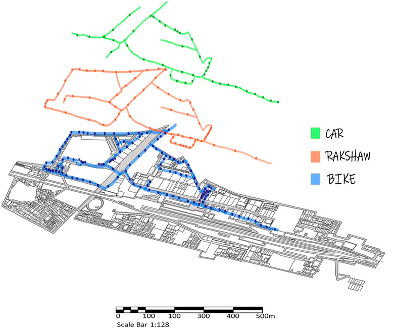
FIGURE 1. Traffic flow diagram.
Such unclear places are usually referred to as leftover spaces in urban design theory. It follows that a piece of land or area that cannot be used effectively due to urban development and design is what is known as the city’s remaining space or leftover space. Unintentionally created open and closed areas from a development or design activity are called leftover spaces (Ayudya et al., 2019). The majority of the research projects that were included in earlier systematic reviews were carried out in sprawling, sparsely populated regions of Australia and the United States. Although there are a few systematic reviews of studies conducted in Asia, the populations that are considered go beyond merely those who reside in densely populated cities (Muller et al., 2020). The provision of high-quality open spaces for urban residents is becoming more and more necessary. Therefore, it is vital to comprehend the characteristics of urban open spaces that are connected to sedentary behavior in dense urban settings in order to define the landscape and urban design standards.
Numerous studies also show the occurrence of urban voids as a result of planning procedures, errors or omissions, or the temporal transformation of urban settlements. Urban gaps can even stealthily appear without any obvious explanation. According to Roger Trancik’s book Finding Lost Space, “undesirable urban spaces” have no positive impact on their surroundings because they are poorly defined, lack definable boundaries, and fail to meaningfully connect elements (Trancik, 1986, 4). These areas are referred to as “lost space” by him. According to Trancik, freeways cutting through cities and changes to the street network system that resulted in the formation of isolated communities and the zoning of those that favored land use segregation and extensive land use alterations led to the establishment of lost spaces in the 1980s. The abandoned railroad sites, relocated industrial sectors, abandoned military or transportation facilities, outdoor parking spaces, and abandoned estates are only a few examples of lost spaces. They also contain leftover throughout spaces that are sparsely scattered across commercial areas.
The researcher identifies the following research questions:
1. What are the various shapes and dimensions of urban voids, and where do they form?
2. How does a land use plan reflect urban voids?
3. What are the ways of utilization of urban voids by city dwellers?
Conceptual framework of research
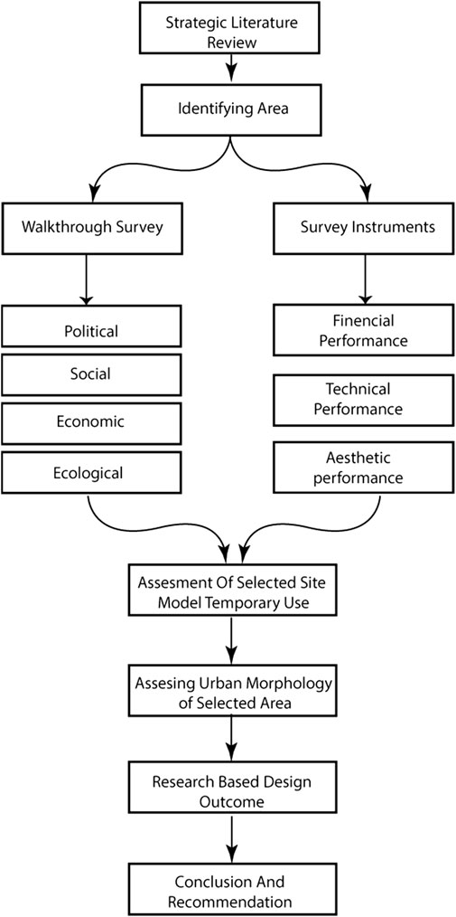
Strategic literature review
According to research reports on the definition and terminologies of urban voids, a comprehensive review of the literature was conducted. Various research databases looked at studies relating to regenerative and interventional associations with urban voids. Only peer-reviewed journal articles having full English texts and having strong methodology and descriptive writing were included. The studies examining the relationship between activity and sedentary behavior in densely populated cities were also included (Monica Motomuraa et al., 2022).
Studies found through the search method were first evaluated based on the title and abstract, with the reputed publications moving on to the full-text evaluation. Studies that satisfied the following requirements were reviewed thoroughly.
• Research was carried out only in densely populated urban regions. Rural or suburban studies that had a lot of open spaces were not included.
• It included both quantitative and qualitative research (using techniques like focus groups, questionnaires, and interviews).
• Studies that looked into public open areas (like parks) and playgrounds were also included. Studies pertaining to private and gated urban open spaces that are not publicly accessible and require an admission fee, as well as studies concentrating on environments like empty lots, urban squares or plazas, and forests, were removed (for example, private yards and private gardens).
• Studies including respondents of any specific age group (children, adolescents, and adults) or those with any illness or impairment were not included.
• All studies considered were required to have been conducted between 2000 and 2022.
Objectives of research
Within the scope of this research, the objectives are as follows:
• Based on user feedback, assess how effectively the urban open space fulfills the users’ expectations during the utilization stage.
• Investigate reasons for dissatisfaction determined during the occupancy stage, develop new design targets that will meet demands or expectations, and improve space performance.
• Ensure space quality and user satisfaction by improving space performance.
In line with the aforementioned objectives, performance and quality concepts were explained and evaluated in this research.
Identification of the area
The identified area for the case study is near Railway Colony in Multan. The selected area is L-shaped and connected with a flyover, which creates a large-scale urban void shown in Figure 2. The spatial methodology, Shown in Figure 3, identified by 1,2 and 3 based on identifying physical conditions and surveys shown in Figure 4, which depends on user ratings, was the foundation of the research methodology. The neighborhood context and urban fabric is strongly associated with the target urban void. The following Figures 2, 4, 5 illustrate the location map of the selected case study:
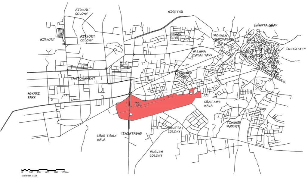
FIGURE 2. Urban void under flyover at the Railway Colony, Multan.
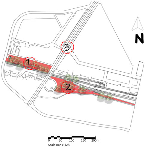
FIGURE 3. Selected urban void.
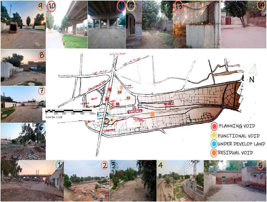
FIGURE 4. Identifying and categorizing the voids within the railway colony.
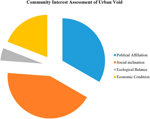
FIGURE 5. Graphical illustration of community inclination.
Site selection criteria for study
The site comprises more than one dead piece of land with a variety of voids shown in Figure 6, with an array of potential uses available in the immediate context of the site. The identified area demonstrates a clear scope and opportunity for place-making. The targeted urban voids were creating a gap between the railway community; therefore, it becomes a prospect to bring people together. The study will be concluded to make a happy interactive place out of a dead sad place. It will be a prototype of the urban regeneration concept, generated from the targeted urban void.
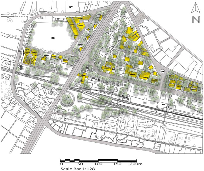
FIGURE 6. Site vegetation plan.
Identification of urban voids
After the identification of urban voids, each void was further categorized on the basis of its functional attributes with more potential. The Table 1 illustrates further categorization of the identified urban voids.
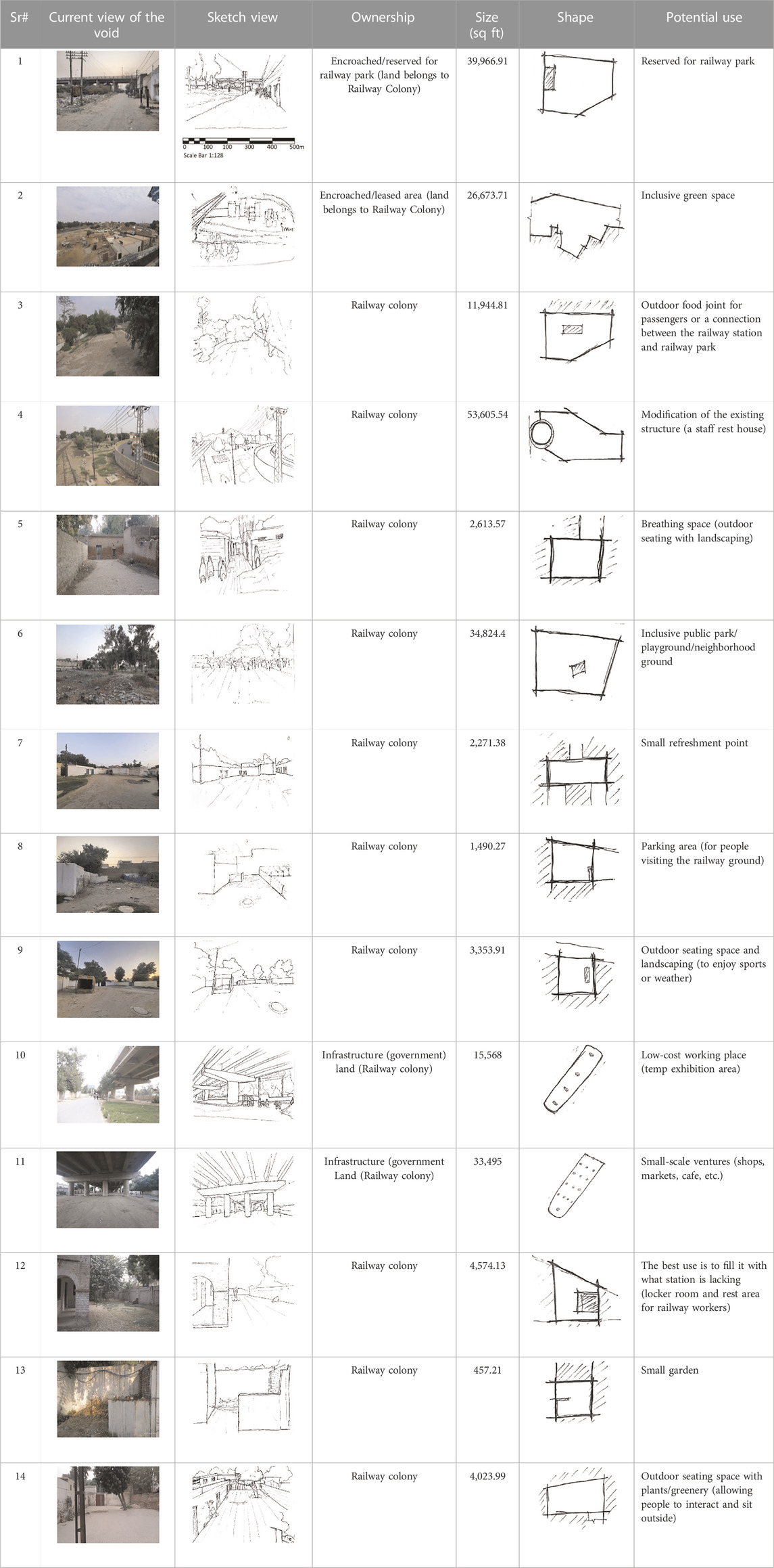
TABLE 1. Site attributes of the identified urban voids.
Walk-through survey
The characteristics that were observed about site attributes during the walk-through survey are discussed in the following Table 1.
Survey instruments
Parallel research was carried out through a questionnaire survey. Three urban voids were selected for this stage identified in Figure 5 and were scored on a 5-point Likert attitude scale. Users who were identified as stakeholders in the study locations participated in surveys. Surveys with 280 users who live in the Railway Colony region were conducted on weekdays and weekends in order to get accurate results.
The survey’s objectives were to ascertain the space’s performance and quality and to ascertain the users’ happiness or dissatisfaction with the spaces identified. In keeping with this objective, it was intended to identify the relative values of the preferred and unfavorable spaces in the Railway Colony region in terms of the performance standards for technical, functional, and aesthetic factors. The study of Doruk Görkem Özkan et al. (2015) was beneficial in the development of closed-ended questions created for performance value determination. Participants’ agreement with these ideas was graded on a scale of 1–5, with 1 representing “I strongly agree;” 2, “I agree;” 3, “I neither agree nor disagree;” 4, “I disagree,” and 5, “I strongly disagree”. (Five performance levels were determined by descriptive analysis as a consequence of established research analyses, and the classification of these performance levels is provided in the Findings section and discussed in Conclusion).
Assessment of the selected site model in temporary use
This component of the study focuses on the well-being and health impact of the urban environment and how urban voids become a tool to facilitate the process of healing of a community. In our urban environment, “no single master plan can anticipate the developing and diversified requirements of a more diverse population or accomplish the durability, responsiveness, and adaptation that shorter-term, experimental initiatives accomplished (Arieff, 2011). In order to close the gap between the perception of a certain durability of physical interventions and the realities outlined in the literature study, we suggest making urban unoccupied space available for temporary (sometimes very short-term) uses and occupations. This will facilitate a gradual urban transformation process and result in contextual, flexible, immediate, and intermediate advantages (Nemeth and Langhorst, 2013). Community gardens on single and multiple lots, small-scale urban agriculture projects, and adaptive reuse of buildings and lots for minor (and frequently alternative/creative) economic operations can all be found on vacant properties. Long-term vacant properties can provide a range of ecological services: deteriorated impervious surfaces and pavement cracks start to let stormwater infiltration; emergent vegetation helps improve air quality and lessen the effects of heat islands; a certain new plant life cleans up contaminated soil; and, aesthetically, such properties can occasionally lessen the appearance of blight. Undeveloped land can present both opportunities and challenges, as Table 1 displays. We are interested in investigating the possibility of uses for vacant land rather than concentrating on how to prevent it despite the fact that this is an important goal. There are three key reasons for this. First of all, empty land offers fantastic prospects for smart growth principles, including infill, brownfield and greyfield redevelopment, and the provision of open and green space in urban cities (Bowman and Pagano, 2014). Second, fully abandoned unoccupied lots accumulate waste and debris and frequently have a detrimental knock-on effect on neighboring properties. For this reason, redevelopment planners should focus on finding opportunities for vacant lots (According and Jhonson, 2000). Third, to resolve perceived negative externalities, unoccupied land might bring together diverse groups, such as homeowners, neighborhood advocates, fire agencies, and realtors (Hou, 2010). Fourth, minority groups are excessively concentrated in neighborhoods with vacant land, a trend that is common in (but not unique to) struggling Rustbelt cities like Detroit, Cleveland, and St. Louis (Nemeth and Langhorst, 2013).
Political, social, economic, and ecological assessment
Considering temporary uses as “a manifestation of a more dynamic, flexible, and adaptive urbanism, where the city is becoming more responsive to new needs, demands and preferences of its users,” we not only contend that there are indeed many benefits to a temporary use model but also acknowledge that there are drawbacks that can be significant. Such benefits and drawbacks can be political (administrative and/or procedural), economic, social, and/or ecological. Such categorization itself has its downsides as it tends to ignore the multi-valency, multiple agencies, and potential synergy of temporary uses. In other words, what stands as a benefit in one category might be construed as a drawback in another (Bishop and William, 2012). The graphical illustration in Table 2 the following analysis justifies the aforementioned assessment.
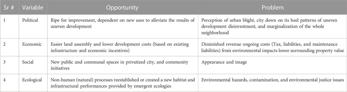
TABLE 2. Views of urban voids (Nemeth and Langhorst, 2013).
Analysis
The presented findings demonstrate how the public perceives the political, social, ecological, and economic conditions of the selected site. It also shows that even when their economic situation has gotten worse, the community of the identified urban void maintains its social preferences. It implies that the area is a government-owned cantonment, is subject to political deception, and is overlooked when it comes to preserving ecological harmony.
Morphological assessment of the selected site
Urban morphology refers to the study of urban form that focuses on the formation and transformation of urban forms of cities, towns, and villages over time; their spatial patterns at different scales; and physical characteristics to inform appropriate urban interventions to promote sustainable urban development. The research took place in the cantonment area of Multan. The selected area is L-shaped and partially under a flyover shown in Figure 7 and is a high-density urban area of the city. Figure 8 illustrates the building age profile for morphological assessment. Observing the selected site model following the morphological assessment was carried out.
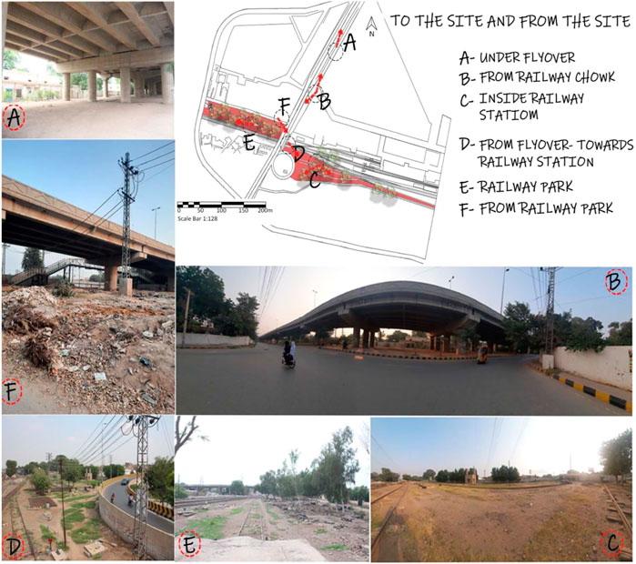
FIGURE 7. Site details and views.
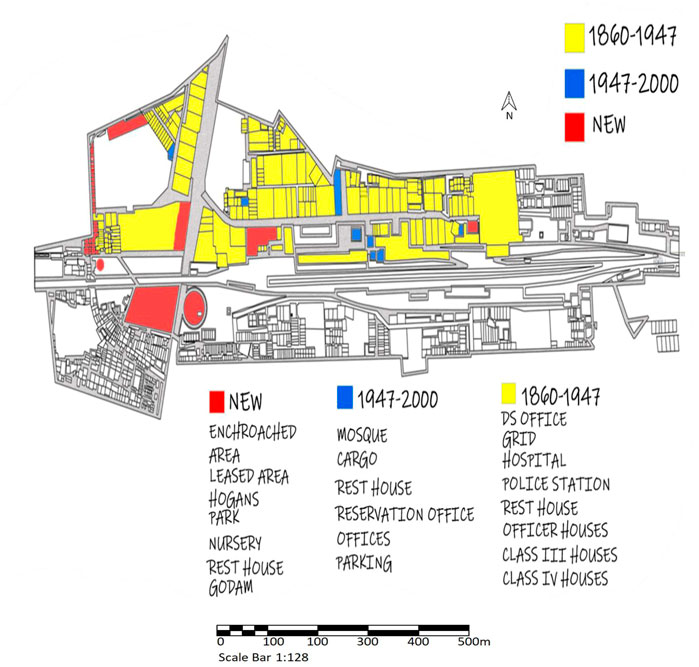
FIGURE 8. Building age profile.
Land use map
Selected under-utilized parcel
The Figure 9 selected under-utilized parcel or urban voids are adjacent to and divided by the railway line (existing as Pakistan’s commonly used communication mode). The identified areas were three in number, considering their existing condition. The chosen urban voids have the following existing attributes observed in a walk-through survey and are discussed in the following Table 1.
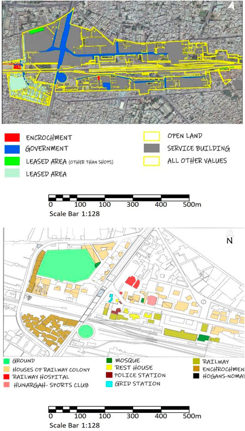
FIGURE 9. Land use map illustrations.
Issues related to the site
During the walk-through survey, the following issues were explored on the selected urban voids.
Site abuse
It is evident that abandoned places quickly turn into hotspots for criminal activity. The state of the Railway Colony’s empty places was similar. They were overflowing with trash illustrates in Figure 7. Unwanted items were tossed into these areas, creating an extremely terrible atmosphere. These abandoned railway segments had the worst aesthetic quality. Under the flyover, there were drug addicts who live, eat, and sleep there, creating an extremely negative impact. Both residents and visitors experience an interruption, and as a result, the area is socially degraded and has become dangerous.
Encroached and leased areas
Another issue with a vacant property is that when it is left unoccupied for an extended length of time, people move in, squat, and live there shows in Figure 9. The same has occurred in the Railway Colony. The nomads occupied these sites and the territory designated for a railway line (which was never built). The remaining land was leased by the Railway department. As a result, the leased and encroached regions are extremely crowded and unplanned. The current state of affairs did not sit well with the community. The current state of affairs makes the neighborhood vulnerable and the environment unpleasant.
Noise and vibration
Although the colony is often quite peaceful, there is a significant amount of noise made when the trains arrive. The sound of the train horn alone is quite loud. Although there is not much activity inside the railroad, when a train arrives or departs, the area fills up with automobiles, which creates a lot of noise and pollution. There is a lot of noise in that area of the community due to the heavy traffic at the flyover. Residents in the area in question have adapted to their environment. When a train approaches, every colony building vibrates, posing a threat to these old structures where employees of the railway department are settled.
Ground and sewerage
The colony has a sizable sports field for its residents. Many individuals congregate each day to play. Boys can be seen playing a variety of games on the field in the afternoon, and many people assemble along the field’s edge to watch the happenings. The community is generally unaware of the health, hygiene, and safety standards, resulting in environmental degradation of the neighborhood and its adjacent land. Surveys have revealed that no such maintenance efforts had been conducted for the ground. Water and sanitation issues are prevalent throughout Pakistan, and the Railway Colony is no exception. Streets were clogged with trash and excrement, creating a difficult situation for the local community. On a larger scale, it has contributed to building a negative image of the historic town of Multan.
Traffic flow
The majority of the population travel by vehicle and motorcycle. People choose to walk to work because the train office station is close to the residential area. When a train departs or arrives, traffic issues are at their worst. Every day, there are between 22 and 24 trains that arrive and depart from the station during half-hour intervals. The train that is prepared to leave departs at 3 p.m. during the busiest time of the day illustrates in Figure 1 in traffic flow diagram.
The Railway Colony’s structures date back to the British colonial era. Most buildings were completed between 1900 and 1940. After the colonials left, from 1947 till the present, only a relatively small number of buildings were constructed. After the partition, cargo offices and parking spaces near the railroad station were added, and the flyover in question was constructed in 2011. A few mosques were built nearby. Old residences require maintenance in addition to new construction.
Research-based design outcomes
Phase-I: Recommending a temporary use model through design interventions
The rationale of the research is to transform these under-utilized urban voids into beautiful public spaces, filling these voids with the needs of the users. Table 3 illustrates the existing site area and its vegetation.
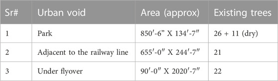
TABLE 3. Existing site area and vegetation.
Site I: Under the flyover
The researcher suggests a flexible structure through temporary made columns illustrates in Figure 10 because permanent structures are not permitted beneath flyovers. Timber and nails are used to build the structure demonstrated in Figure 11. It is constructed such that the carters will use the area once the exposition is over. Additionally, any other railroad employee who wishes to run a small business can set up the shop.
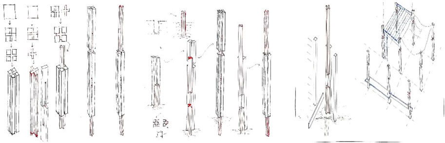
FIGURE 10. Column details.
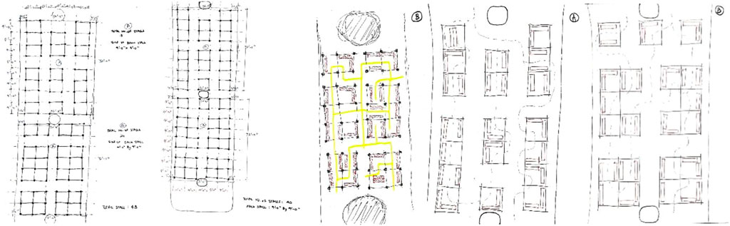
FIGURE 11. Arrangement of the column and circulation pattern.
There are few arrangements of the stalls. It is designed on a 9ʹ-0″ by 9ʹ-0″ grid, an ideal size of a stall for any kind of display.
Site II: Park
There should be a park there, but there was none despite it being marked as such on Google Maps. Some claimed that there was once a park, but it was destroyed during the bridge’s building, while others claimed there never was one. It is a 2-kanal area that is deserted and inhabited by nomads. The locals were not pleased with them. The location has been repeatedly cleared by railway security, but they eventually return.
As a result, a long-term solution was required. Parks could be created such that they are always occupied by people and are no longer merely empty spaces. The community requires a place to mingle, after all, a location where everyone is welcome, regardless of their class, gender, or age. Figure 12 illustrates the sketches of playground elements for kids.
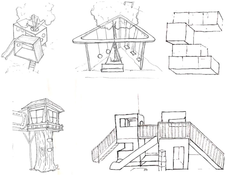
FIGURE 12. Sketches of playground elements for kids.
Site III: Adjacent to the railway-line
The finest choice when taking into account the third urban void was the design of the porters’ rest area and locker room. The porters were interviewed on the amenities provided to them at the station. The findings indicate that 150 porters were altogether present at the railroad station at any given time when a train arrived or left. The study recommended using a low-cost climate-responsive design.
Compressed earth bricks (CSEBs), which are readily available and reasonably priced regionally, were suggested for the building design. They were made up of Portland cement, non-expansive clay, aggregates, and dry inorganic subsoil. An eco-friendly substitute for clay bricks is a CSEB (compressed stabilized earth block). Figure 13 illustrates compressed earth block sections- construction and material details.
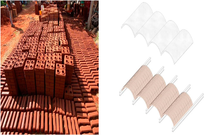
FIGURE 13. Compressed earth block sections—construction and material detail.
Phase-II: Suggested design interventions master plan of identified urban voids
Suggested design interventions is shown and recommended in Figure 14. Design Intervention Master plan. All three identified Voids are shown after design arbitration.
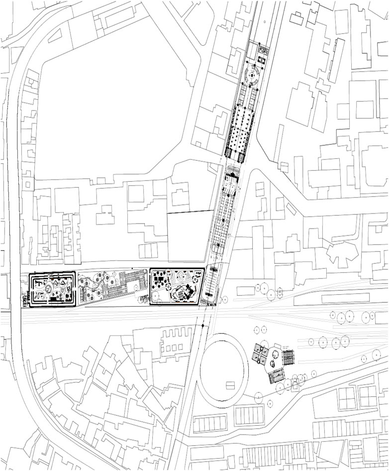
FIGURE 14. Design interventions master plan.
Conclusion and recommendations
The research has highlighted some of the profound factors relating to urban voids and their potential use through design interventions, as suggested in this paper.
• The community is at the core of any intervention being proposed. Therefore, their active participation is at the core of any design. Most of the issues can be handled through a participatory process. This will also enable long-term use and value addition to the selected site.
• Participatory process never imposes a design solution on a community. It strengthens the aspirations arising from within the community itself. The community native to our site is the employee body of the Railway Colony, and the members are from similar economic strata of our society. They shall be motivated and utilized in the best interest of the community.
• Youth participation is also very important in revitalizing the neighborhood. All design interventions must bring together physical activities to empower youth and provide them with safe and green healthy areas to hang around.
• The community needs to become resilient in safeguarding its best interests. The role of a designer is of a facilitator to achieve a functional, socio-cultural, and aesthetic environment utilizing the urban voids.
Data availability statement
The raw data supporting the conclusion of this article will be made available by the authors, without undue reservation.
Ethics statement
Ethical approval was not provided for this study on human participants, because the research was made on user satisfaction, the assessment of urban neglected areas was descriptive and had research based design outcome solutions. Written informed consent for participation was not provided by the participants and legal guardians/next of kin because a questionnaire was used as a research instrument, so no written consent was initially required.
Author contributions
All authors made sentential, intellectual, direct contribution to the work and approved it for publication.
Conflict of interest
The authors declare that the research was conducted in the absence of any commercial or financial relationships that could be construed as a potential conflict of interest.
Publisher’s note
All claims expressed in this article are solely those of the authors and do not necessarily represent those of their affiliated organizations, or those of the publisher, the editors, and the reviewers. Any product that may be evaluated in this article, or claim that may be made by its manufacturer, is not guaranteed or endorsed by the publisher.
Footnotes
1(United States 2020) https://www.un.org/en/development/desa/population/publications/pdf/ageing/WorldPopulationAgeing2019-Report.pdf
References
According, J., and Jhonson, G. T. (2000). Addressing the vacant and abandoned property problem. J. Urban Aff. 22, 301–315. doi:10.1111/0735-2166.00058
Akkerman, A., and Cornfeld, A. F. (2010). Greening as an urban design metaphor: Looking for the city’s soul in leftover spaces. Struct., 30–35.
Ayudya, D., Anggiani, M., and Heryanto, B. (2019). “Carrying out residual space in marginal waterfront settlement,” in City plann. And environ. Management in asian countries, 1–4.
Belanger, M., and Foster, C. (2011). Worldwide prevalence of physical inactivity calls for worldwide actions. Prev. Med. 53, 29–30. doi:10.1016/j.ypmed.2011.05.008
Bowman, A. O. M., and Pagano, M. A. (2000). Transforming America’s cities policies and conditions of vacant land. Urban Aff. Rev. 35, 559–581. doi:10.1177/10780870022184534
Bowman, A. O. M., and Pagano, M. A. (2014). Rethinking urban transformation: Temporary uses for vacant land. Cities 40, 143–150. doi:10.1016/j.cities.2013.04.007
Farid, N., Ul Moazzam, M. F., Ahmad, S. R., Rosa, C., and Lanfred, M. (2022). Monitoring the impact of rapid urbanizationon land surface temperatureand assessment of surface urban heat island using Landsat in megacity (Lahore) of Pakistan. Front. Remote Sens. 3, 13. doi:10.3389/frsen.2022.897397
Goldstein, J., Jensen, M., and Reiskin, E. (2001). Urban vacant land redevelopment: Challenges and progress. 37. Cambridge, MA: Lincoln Institute of Land Policy.
Hajna, S., Ross, N. A., Brazeau, A. S., Belisle, P., Joseph, L., and Dasgupta, K. (2015). Associations between neighbourhood walkability and daily steps in adults: A systematic review and meta-analysis. BMC Publ. Health, 768.
Hou, J. (2010). Insurgent public space, guerilla urbanism and the remaking of contemporary cities. London. London: Routledge.
Hwang, S. W., and Lee, S. J. (2019). Unused, underused, and misused: An examination of theories on urban void spaces. Urban Research and Practice, 18.
Kalwar, S. (2022). A comperative analysis of urbanizationt trends of hyderabad and sukkur. Acad. Strategic Manag. J., 9.
Kushwah, N., and Rathi, K. (2017). Urban voids–reclaiming urban space. Int. J. Adv. Res. Ideas Innov. Tech. 3 (1), 196–203.
Motomura, M., Koohsari, M. J., Lin, C. Y., Ishii, K., Shibata, A., Nakayad, T., et al. (2022). Associations of public open space attributes with active and sedentary behaviors in dense urban areas: A systematic review of observational studies. Japan: Elsevier.
Muller, A. M., Chen, B., Wang, N. X., Whitton, C., Direito, A., Petrunoff, N., et al. (2020). Correlates of sedentary behaviour in asian adults: A systematic review. Obes. Rev. 21, e12976. doi:10.1111/obr.12976
Myers, D., and Wyatt, P. (2004). Rethinking urban capacity: Identifying and appraising vacant buildings. Building Research and Information, 285–292.
Nemeth, J., and Langhorst, J. (2013). Rethinking urban transformation, temporary uses for vacant land. Cities (Elsiver) 40, 143–150. doi:10.1016/j.cities.2013.04.007
Ozkan, D. G., Alpak, E. M., Yılmaz, S., Düzenli, T., and Ali, Ö. (2015). Post occupancy evalation and user satisfaction in Urban open space. Fresenius Environ. Bull. 24 (5), 1659–1672.
Pearsall, H., Lucas, S., and Lenhardt, J. (2014). The contested nature of vacant land in philadelphia and approaches for resolving competing objectives for redevelopment. Cities 40, 163–174. doi:10.1016/j.cities.2013.04.008
Rahmann, H., and Jonas, M. (2011). Urban voids: The hidden dimension of temporary vacant spaces in rapidly growing cities, 1–11.
Reyes-Riveros, R., Altamirano, A., De La Barrera, F., Rozas-Vasquez, D., Vieli, L., and Meli, P. (2021). Linking public urban green spaces and human well-being: A systematic review. Urban Green, 61.
World Health Organization (2018). Prevalence of insufficient physical activity among adults aged 18+ years (age-standardized estimate) [Online]. United Nation: World Health Organization.Annual Report.
Keywords: urban voids, urban catalyst, space performance, user satisfaction, urban open spaces
Citation: Aleha A, Zahra SM, Qureshi S, Marri SA, Siddique S and Hussain SS (2023) Urban void as an urban catalyst bridging the gap between the community. Front. Built Environ. 9:1068897. doi: 10.3389/fbuil.2023.1068897
Received: 13 October 2022; Accepted: 27 February 2023;
Published: 18 April 2023.
Edited by:
Soufiane Fezzai, University of Tébessa, AlgeriaReviewed by:
Ahmed Mustafa, The New School, United StatesAbida Hamouda, University of Batna, Algeria
Copyright © 2023 Aleha, Zahra, Qureshi, Marri, Siddique and Hussain. This is an open-access article distributed under the terms of the Creative Commons Attribution License (CC BY). The use, distribution or reproduction in other forums is permitted, provided the original author(s) and the copyright owner(s) are credited and that the original publication in this journal is cited, in accordance with accepted academic practice. No use, distribution or reproduction is permitted which does not comply with these terms.
*Correspondence: Anum Aleha, YW51bS5hbGVoYUBuZmNpZXQuZWR1LnBr