 Mohamed Salah Ezz
 Ashraf M. Soliman
 Mohammed Aldelgawy
 Doaa A. H. Salem6
- 1Department of Architecture, College of Engineering and Information Technology, Onaizah Colleges, Qassim, Saudi Arabia
- 2Department of Architecture, The Higher Institute for Engineering and Technology of Obour, Cairo, Egypt
- 3Department of Architectural Engineering, College of Engineering and Design, Kingdom University, Riffa, Bahrain
- 4Faculty of Engineering, Minia University, Minia, Egypt
- 5Civil Engineering Department, Faculty of Engineering, Fayoum University, Fayoum, Egypt
- 6College of Architecture Engineering and Digital Design, Interior Design Department, Dar Al Uloom University, Riyadh, Saudi Arabia
- 7Civil Engineering Department, Faculty of Engineering, Assiut University, Assiut, Egypt
- 8Civil Engineering Department, College of Engineering and Information Technology, Onaizah Colleges, Qassim, Saudi Arabia
Introduction: Spatial analysis documentation and visualization achieve through Geographic Information Systems (GIS) handles essential functions for heritage asset management. The research develops a 3D GIS platform that supports Al-Ahsa heritage building conservation as a UNESCO World Heritage Site through advanced spatial technology.
Methods: The collection of data occurred via historical record indexing together with stakeholder dialogue methods. The developed 3D GIS system merges heritage data of multiple categories including general and historical and urban elements along with architectural aspects and structural construction records through a structured relational database. Into this system researchers combined spatial analytics through GIS with web-mapping functions and three-dimensional modeling for telecommuting purposes and group decision-making features.
Results: The developed system generated high-quality three-dimensional models together with crucial spatial information for preservation needs. The system enabled better understanding of cultural and historical components during urban planning tasks and architectural reviews. Through this platform building-structural data could be accessed precisely to conduct risk assessments that supported resource management decisions.
Discussion: Heritage site management receives improved benefits because of 3D GIS platforms which unite various types of data into a unified framework. This approach demonstrates scalability that makes it suitable for expanded use in heritage preservation projects.
Conclusion: The application of 3D GIS technology represents a beneficial element enabling heritage preservation through systematic record-keeping while offering visual representations and risk monitoring features. This technology demonstrates potential use as basis for building future protection strategies in heritage preservation.
1 Introduction
Heritage assets, encompassing both material and non-material types, are regarded as the living memory of individuals and nations. Given their significance, national and local efforts have been undertaken and continue to be made to conserve these valuable assets. Documenting cultural heritage in all its forms and types is considered one of the most critical and foundational operations for conservation. However, the documentation process is characterized by significant challenges, including the necessary collection of information related to cultural assets. Despite these efforts, heritage documentation remains a challenging process due to the complex nature of these assets, which includes surveying, registration, classification, dating, and identifying their significance and values (González et al., 2024). The multiple challenges tied to traditional documentation practices have driven historical project handlers to seek better and smarter ways to preserve their heritage assets. Innovative approaches focus on developing more sustainable technologies to document cultural heritage properties with their diverse features.
The integration of advanced technologies that utilize geographic information system (GIS) brings the opportunity to transform the way cultural heritage receives documentation and preservation treatment. GIS delivers exact representations of heritage sites but enables spatial analysis along with visual tools needed to evaluate potential hazards and develop conservation strategies (Monchetti et al., 2023). Studies have already demonstrated that GIS technology presents many benefits for urban planning when combined with heritage protection initiatives. Research by Ibtissem et al. (2024) demonstrated that GIS effectively detects and interprets temporal urban transformations in order to help protect heritage sites in Algeria’s fast-developing urban areas. The study by Özer and Yalçıner Ercoşkun (2024) showed how GIS can assess environmental risks, including flooding, which is crucial for heritage sites in vulnerable locations.
Numerous architectural heritage sites declared by UNESCO can be found across Saudi Arabia’s territory (Yazdani, 2024). The sites retain exceptional historical importance and both cultural and scientific value. Existing research demonstrates that contemporary innovative documentation methods maintain cultural value and serve to protect architectural sites (Bay et al., 2022; Mazzetto and Vanini, 2023). These heritage assets must be preserved using advanced documentation technologies with a focus on GIS since it emerges as a vital instrument for sustaining heritage sites and crucial planning decisions in cultural preservation management. Saudi Arabia’s Vision 2030 works to establish economic diversification while creating sustainable development through dedicated initiatives, which focus on advanced programs for historical and cultural site preservation. This national strategy indicates that cultural heritage serves as a major economic force and social driver while advocating for the implementation of advanced documentation and preservation technologies in urban settings (Ba et al., 2022). The vision presents World Heritage management trends that support utilizing advanced technology in heritage preservation practice. The systematic method of cultural and historical asset protection produces heritage management, which verifies their long-term survival and sustainable utilization. The protection of tangible and intangible heritage becomes possible through policies and strategies along with technological applications in this systematic process (Alqahtany and Aravindakshan, 2022)
Heritage building data collection, including classification and information analysis, requires organized data aggregation methods for clear representation. The successful completion of comprehensive and valuable data depends on cooperation between architects, archaeologists, and urban planners through interdisciplinary collaboration (González et al., 2024; Li et al., 2022).
A well-functioning documentation system needs to incorporate 3D modeling functionality alongside diverse information formats for efficient storage and operational integration, supporting ease of use and system interoperability. This system allows different groups to access data for several functional requirements, leading to enhanced communication processes and better decision-making quality (Wang et al., 2021; D'Urso et al., 2017)
Previous studies related to this research focus show 3D GIS applications in heritage conservation. These studies indicate that digitizing operations leads to superior documentation quality while boosting preservation outcomes in heritage protection initiatives. These researchers (Keep, 2022; Saygi et al., 2018) documented Italian historical structures by integrating 3D GIS technology with architectural records and historical documentation to support preservation decisions. The integration of 3D GIS with Building Information Modeling (BIM) was demonstrated by Mazzetto and Vanini (2023) in France, showing that restoration projects could be more effective because of large-scale data cooperation. The case study in Greece showed how 3D GIS enables risk assessments of natural disaster threats to heritage sites while developing specific conservation interventions (Yazdani, 2024).
Furthermore, a Turkish study performed hypothetical archaeological site reconstruction utilizing 3D GIS systems to demonstrate how these technologies serve educational and tourist scenarios for cultural heritage outreach. Chinese researchers employed 3D GIS to inventory UNESCO World Heritage sites (González et al., 2024; Yazdani, 2024; Mazzetto and Vanini, 2023; Agapiou et al., 2016), demonstrating how this technology meets the need of two key stakeholders: cultural heritage management workers and asset preservation efforts through detailed spatial data analysis. 3D GIS applications for monitoring UK historic landscapes demonstrate how cultural preservation tactics gain efficiency through mapping-built spaces with their setting context (Thomas, 2023). Canadian indigenous heritage sites received documentation through 3D GIS technology, which combined indigenous traditional knowledge to preserve sites in a culturally sensitive manner. Research conducted in Brazil, combined with studies from Australia, demonstrated how 3D GIS revolutionizes cultural heritage management through its urban and community outreach designs (Fiorini et al., 2022).
The documentation of heritage site plays a crucial role in urban planning by providing essential information for sustainable development while ensuring cultural heritage protection (Giuffrida et al., 2021) Through precise spatial analysis, 3D models detect potential threats, which lead to the creation of risk mitigation strategies to safeguard heritage sites throughout their extended preservation period. The integration of GIS with other databases facilitates managing heritage sites, helps society maintain heritage sites, and encourages choices that support sustainable urban development.
Finally, this research aims to implement innovative methods to unify GIS capabilities in heritage documentation processes while developing advanced interactive systems for data organization.
2 Study area
The eastern Saudi Arabian city of Al-Ahsa is located at 25.4° N latitude and 49.6° E longitude, where it maintains its status as an internationally recognized center because of its rich cultural legacy and the UNESCO World Heritage-listed Al-Ahsa Oasis. The Al-Ahsa Oasis represents an exceptional ecocultural landscape, with featuring an organized succession of trenches, springs, wells, nurseries, and historical structures that demonstrate unbroken human settlements from the Neolithic period to the present day. With more than 2.5 million date palm trees, it is the largest oasis in the world and a remarkable example of human-environment cooperation (UNESCO, 2220) (Vacca et al., 2018; Salvemini, 1999; Wu et al., 2024; Yang et al., 2020).
Al-Ahsa Oasis is considered a vital source of its agricultural heritage, as well as its historical and architectural sites, including ancient forts, mosques, and traditional water management systems. Figure 1 shows a map of the Al-Ahsa region, located in the Eastern Province of Saudi Arabia. The map highlights the geographical location of Al-Ahsa and marks the positions of its key heritage sites, including Qasr Ibrahim, Qasr Sahood, Suq al-Qaysariya, and other notable landmarks. The figure serves as a spatial reference for understanding the distribution of cultural and historical sites within the oasis. These heritage assets define the development of a dynamic social custom and economically sustainable practices of the communities that have occupied the region for millennia. The UNESCO designation features the significance of preserving this cultural landscape, which continues to play a fundamental role in the local economy and community identity. Efforts to document and manage these heritage sites are crucial for their security and sustainability for future generations (Rinaudo et al., 2007; Elfadaly et al., 2020; Kumar et al., 2023; Colucci et al., 2023; Karpinskyi et al., 2024)
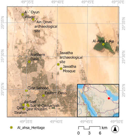
Figure 1. Study area of Al-Ahsa. Source: The authors.
2.1 Archaeological view
In Saudi Arabia, Al-Ahsa is recognized as one of the main archeological and historical areas. Al-Ahsa Oasis, a UNESCO World Heritage site, represents a rich tapestry of human settlement that has persisted from the Neolithic period to the present day. Historically, Al-Ahsa has filled in as an essential rural center point, profiting from its plentiful water assets, which have upheld broad date palm development and other farming exercises (Branchini, 2015; Ettorre et al., 2023; Ginzarly et al., 2018; Garzulino et al., 2021).The oasis has been decisively significant since the beginning of time, functioning as a junction for exchange and social trade in the Middle Eastern continent. Al-Ahsa’s geological area has made it a vital region for different civilizations, including the old Nabataeans and later Islamic traditions. The archeological remains in Al-Ahsa reflect a diverse cultural heritage, featuring numerous sites, including ancient forts, traditional mud-block houses, and historic mosques (Alfelali, 2024; Stylianidis et al., 2022; Mahdy, 2016).
Key archeological sites inside Al-Ahsa are displayed in Figure 2. The figure showcases photographic examples of Al-Ahsa’s heritage sites, including (a) Qasr Ibrahim: a prominent Ottoman-era palace featuring a mosque with a domed roof, a central courtyard, and fortified walls. (b) Qasr Sahood: another historical fort in Al-Ahsa, known for its defensive architecture and strategic importance. (c) Suq al-Qaysariya: a traditional market that reflects the region’s vibrant trade history and cultural heritage. (d) Traditional well in Qasr Sahood: a representation of the water management systems that supported life in the oasis. This figure provides visual evidence of the diversity and richness of Al-Ahsa’s heritage. Each subfigure highlights a different aspect of the region’s cultural and historical significance. These systems highlight the integration of environmental and social practices that have supported the local population for centuries (Rjoub and Al-Azhari, 2011; Baik, 2021; Stylianidis et al., 2022; Quintilla-Castán, 2023). Moreover, various archeological discoveries from Al-Ahsa reveal pottery, tool sets, and recorded writings, collectively illustrating how individuals lived their lives throughout history. These findings contribute to Al-Ahsa’s analytical heritage value as a primary cultural center in the Arabian Peninsula, earning deep appreciation from scholars and historians (Mayaleh and Hamamra, 2024).
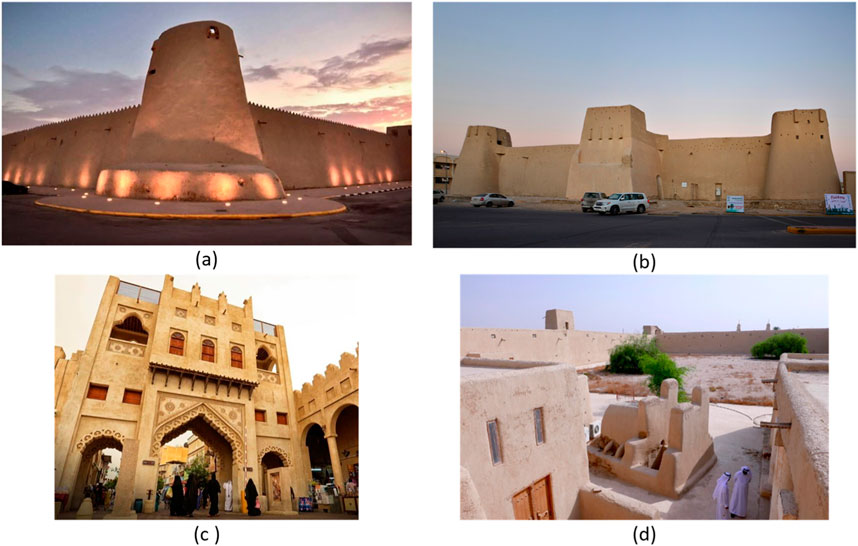
Figure 2. Examples of Al-Ahsa heritage sites: (A) Qasr Ibrahim, (B) Qasr Sahood, (C) Suq al-Qaysariya, (D) Traditional well in Qasr Sahood. Source: https://whc.unesco.org/en/list/1763/gallery/.
2.2 Problem definition
The sustainability of historical records, along with local identities, relies heavily on preserving and managing cultural heritage sites. The UNESCO-listed Al-Ahsa Oasis in Saudi Arabia experiences major threats due to fast city development alongside climatic changes and missing documentation approaches, which jeopardize both the protection and long-term viability of this ancient archaeological landscape (González et al., 2024; Bay et al., 2022; Saygi et al., 2018).
The spatial information databases adopt substandard management tools to track the analysis and protection of archaeological resources. Heritage preservation strategies typically fail to address the noteworthy complexities of urban development coupled with the changing environmental elements that impact the Al-Ahsa Oasis and its preserved historical sites, despite expert’s recognition of the region’s cultural value. The information systems do not provide adequate spatial data together with sophisticated management solutions to successfully track and safeguard these archaeological assets. Traditional heritage conservation practices show inadequacy when they must handle the combined stress of urban growth challenges along with environment-dependent changes to oasis landscapes and historical constructions (Bay et al., 2022; Stylianidis et al., 2022; Alfelali, 2024)
Therefore, the research targets this problem through the development of an inclusive documentation system using 3D GIS technology with web-mapping capability. The system provides an advanced solution to resolve traditional method limitations for merging spatial and non-spatial data when conducting conservation planning and making decisions. This research highlights the essential necessity for new approaches, which bring together modern technological expertise with solid heritage management knowledge to create lasting preservation techniques (Ettorre et al., 2023; Stylianidis et al., 2022).
3 Materials and methods
3.1 Materials
This research focused on choosing significant historical sites located throughout Saudi Arabia’s Al Ahsa region to develop a 3D GIS framework. The study utilized an open-source framework to collect and store data on various attributes of these historical sites. Using the interdisciplinary method, the research included multiple expert perspectives, which deepened the scientific comprehension of site materials, structural characteristics, and spatial dimensions. The acquired data help researchers in designing advanced solutions for sustainable robust management practices (Bay et al., 2022; Alfelali, 2024).
1. Qasr Ibrahim: Qasr Ibrahim exists as historic evidence of traditional Islamic architecture and presents the region’s rich historical heritage. The facility showcases artistic styles that result from diplomacy and trade activities in Al-Ahsa, making it foundational for studying cultural exchanges and architectural transformations.
2. Suq al-Qaysariya: For centuries, Suq al-Qaysariya functioned as an essential commercial hub, solidifying its role in business operations and cultural exchange. The design of the place and its organization provide historical insights into active trading practices, social customs, and key economic developments in Al Ahsa.
3. As-Seef: As-Seef stands as both an aesthetic attraction and serve as a symbol of the Arab population’s profound bond with nature. The site demonstrates how local social practices and community life evolved because of natural resources over time.
4. Qasr Khuzam: Among the significant architectural masterpieces, Qasr Khuzam embodies multiple styles developed across the entirety of Al Ahsa’s history. This site functions as a visible gateway to understanding how governance methods and cultural trends shifted throughout the community’s development.
5. Qasr Sahood: This site is known for its archeological richness. Qasr Sahood provides extensive historical and cultural information, showing us how past civilizations lived their lives and operated administrations in Al Ahsa.
6. Jawatha Archeological Site: Archeologists praise Jawatha as one of the most historically significant locations because it contains remains of historic buildings and artifacts. An abundance of historical information at Jawatha allows researchers to better interpret regional history.
7. Jawatha Mosque: As one of the region’s earliest mosques, Jawatha Mosque stands both as a masterpiece of architecture and as a spiritual beacon for the regional population. This historic structure served as a crucial center for the Islamic expansion in Al Ahsa through the dedication of local residents.
3.2 Methodology
The methodology for the Al Ahsa 3D GIS project, as shown in Figure 3, is structured into three main phases, namely, data design, data collection, and data representation. In the data design phase, comprehensive information about the heritage site is organized into four categories, namely, general information (e.g., location and size), historical information (e.g., cultural significance and timeline), urban and architectural data (e.g., building layouts and materials), and structural data (e.g., condition and stability). The data collection phase involves collecting this information through historical documents (e.g., archives and manuscripts) and field visits (e.g., surveys, photographs, and measurements). Finally, in the data representation phase, the collected data are integrated into a geodatabase for structured storage and management, and a web map is created to visualize and share the 3D GIS data, enabling interactive access and analysis of the heritage site’s spatial and historical attributes. This approach ensures systematic and detailed documentation of the heritage site, combining historical context with modern geospatial technology.
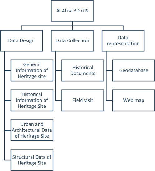
Figure 3. Research methodology.
3.2.1 Pre-processing
Cultural heritage data standardization within Al-Ahsa resolves documentation completeness issues and provides uniform information enablement along with data preservation security Campanaro et al., 2016. The establishment of standardized heritage information protocols along with national and international standards produces efficient datasets, enabling critical heritage data exchange required for Al-Ahsa’s culturally diverse asset management. Data safeguarding and long-term preservation require secure technologies capable of managing extensive databases that resist programmed dilapidation. Various databases exist at local, national, and global levels, such as the “Core Data Index to Historical Buildings Huang, 2024; Mousazadeh et al., 2023, which standardizes the documentation of Al-Ahsa’s architectural heritage.
3.2.2 Data models
In the field of cultural heritage, advancements in technology have created immense amounts of data related to the digital representation of objects. There is a growing interest in interoperability between systems due to the variety of disciplines involved (Thomas, 2023; Elfadaly et al., 2020; Ettorre et al., 2023).
This challenge can be addressed through conventional ontologies and semantic models. The Semantic Web needs normalized and accessible datasets, which share information interoperable through W3C-developed standards that include XML, RDF, OWL, and SPARQL (Fiorini et al., 2022; Karpinskyi et al., 2024; Quintilla-Castán, 2023).
3.2.3 Coherent information architecture
To classify architectural heritage, we need appropriate data structures for building 3D models that effectively merge separate data types. Scientific research has made remarkable progress, evolving from initial two-dimensional data systems evolving into modern, sophisticated systems that utilize three-dimensional models (López et al., 2018; Ettorre et al., 2023).
A unified information system requires integration to build a robust graphical database, connecting the complex requirements of heritage protection specialists (Alqahtany and Aravindakshan, 2022; Garzulino, Borgarino and Del Curto, 2021). This system allows multiple specialists to work from a shared information framework, which enables modifications to their combined database.
3.3 Comprehensive analysis of heritage sites in Al Ahsa
This research presents a comprehensive analysis of the selected heritage sites in Al Ahsa, supported by detailed data organized into four categories, namely, general data, historical data, urban and architectural data, and structural data. For clarity, the data on Qasr Ibrahim will be used as an example of the asset attribute data in the following four tables, which represent the four categories of attribute data. This study relies on 3D GIS modeling and web-based mapping tools to establish connections between different datasets, which generates a merged view of each site’s extensive background.
3.3.1 General information of heritage site
This category of data presents basic information on each site by examining its geographical position along with historical milestones and functional activities. Table 1 (Rjoub and Al-Azhari, 2011) exhibits how this initial foundational data present the context that enables decision-makers and conservationists to integrate spatial and non-spatial information within the GIS database.
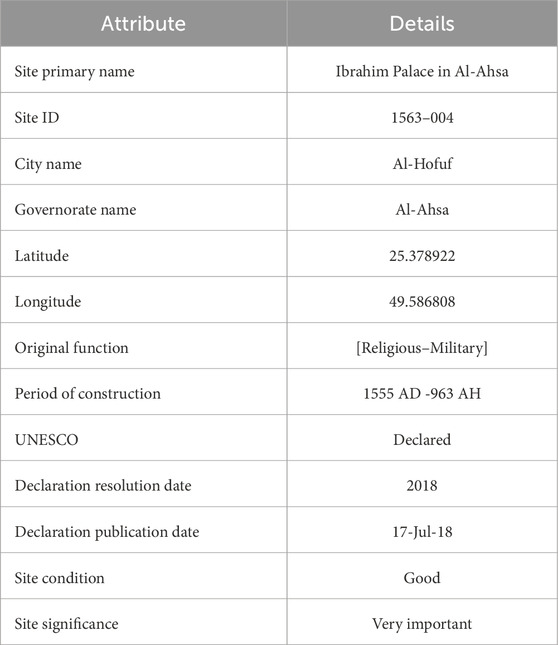
Table 1. General data on heritage site, example of Qasr Ibrahim data.
3.3.2 Historical information of heritage site
This section presents significant historical data on the site and chronology of the development and assessment of its heritage worth. By examining these aspects, the study enhances the understanding of the historical significance of heritage sites, as shown in Table 2.
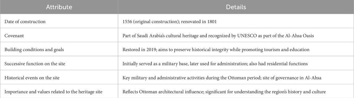
Table 2. Historical data on heritage site, example of Qasr Ibrahim data.
3.3.3 Urban and architectural data of heritage site centers
The section investigates the connection between each heritage site and its architectural building styles with its urban planning arrangements. The essay investigates distinct architectural components and instrumental building arrangements with unique construction methods that define the character of these buildings. This section evaluates physical components with an examination of the architectural styles that represent social, religious, and political beliefs from specific time periods. Architecture provides essential information on the social organizations through an examination of its cultural background. The spatial design of a structure can display aspects of community activities, spiritual customs, and social ranking structures, and buildings use specific stylistic choices to represent cultural practices, as show in Table 3.
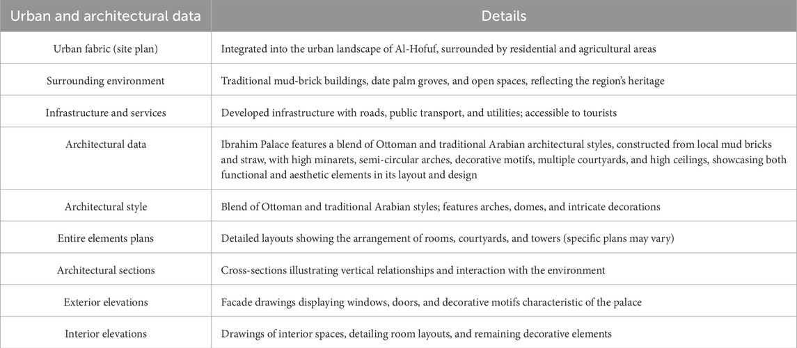
Table 3. Urban and architectural data of heritage site, example of Qasr Ibrahim data [37].
3.3.4 Structural data of heritage site presents
Technical information regarding building materials, techniques, and the current conditions of heritage sites is critical for assessing the conservation needs and planning potential restoration efforts to preserve these cultural assets, as shown in Table 4.
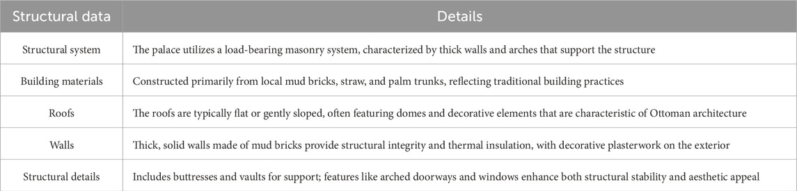
Table 4. Structural data on heritage site, example of Qasr Ibrahim data.
3.4 The integrated information system is organized into three specialized subsystems
A-Documentation framework: This framework delivers a high-quality 3D mathematical model, which serves as a foundation for overlaying data from various configurations. It establishes connections through attributes linking divers’ metadata, facilitating inquiries and selections (Soler et al., 2017; Quintilla-Castán, 2023).
B-Geographic data framework (GIS): Responsible for storing and arranging data for easy access, the GIS utilizes standards and ontologies to improve interoperability between datasets. It integrates information from the documentation and administration frameworks, addressing visualization challenges for landscapes, objects, and buildings while managing large volumes of data for analysis and dissemination (Yang et al., 2020; Rjoub and Al-Azhari, 2011).
C-Management system: This subsystem offers logical support for damage assessment and intervention planning in conservation efforts. It ensures that data derived from the current model are accessible and actionable (Elfadaly et al., 2020; Garzulino et al., 2021).
4 Results
To conduct the inventory of Al-Ahsa heritage, which focuses on administrative and protective tasks, information has been gathered on urban planning regulations and the relationship between buildings and their surroundings. The graphical representation of these data, along with its correlation to heritage and geolocation, supports spatial analysis for conservation and dissemination purposes. The authors have designed a web map with attribute data of the heritage sites that enable users to access the data from any location, as well as to view, consult, analyze, or export it in various formats. The inventory consists of a database that includes details related to identification and location, historical data, types of protection, geometric and construction characteristics, conservation status, and types of interventions, as illustrated in Figure 4. Additionally, it serves as a valuable tool for decision-making, aiding in the preparation of inventories focused on protection and conservation. It provides a broader perspective of the buildings within an urban and territorial context, rather than viewing them as isolated structures. Users can access structured data through an interface that offers various display options, customizable based on the intended use of the information, whether technical or informative, thereby expanding its potential applications. The web map can be accessed through Google Maps or Google Earth.
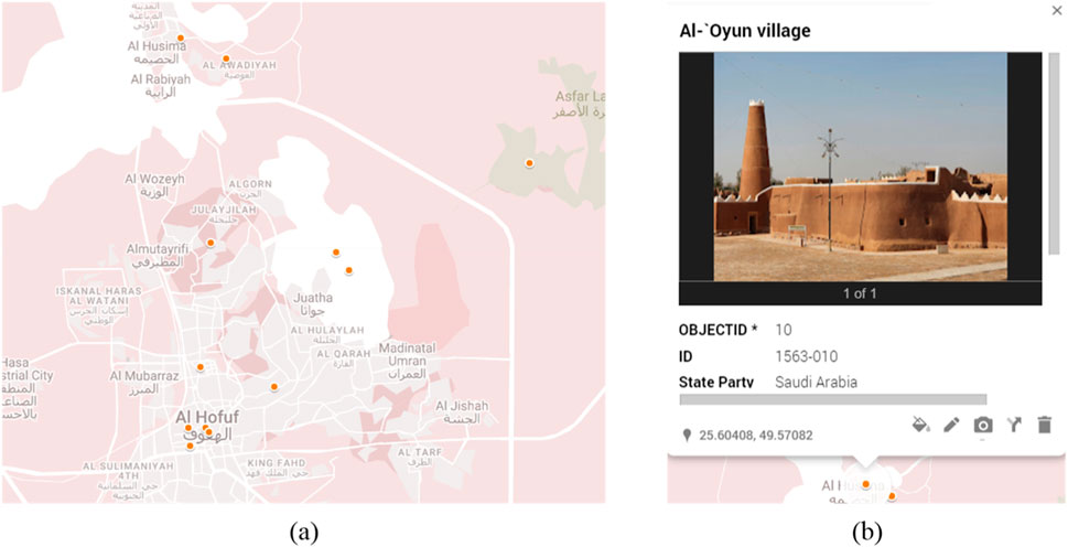
Figure 4. Web map has been developed to facilitate the dissemination of Al-Ahsa architectural heritage. (A) View the geolocation of heritage sites and (B) access attribute data about the assets upon inquiry.
The system was developed to meet specific standardization requirements. To represent heritage documentation, different levels of detail (LoD) are used, which allow the visualization and analysis of the same object at different scales and degrees of resolution simultaneously Biljecki et al., 2016. This provides efficient access to the data, reduces latency, and improves compression. LoD level 0 offers a general vision, corresponding to the scale of the territory and landscape, specifically focusing on the area of Al-Ahsa. LoD 1 shows the urban scale at the city level, without differentiated structures or textures, while LoD 2 represents architectural models from an external view. LoD 3 completes the definition of the interior of the architectural model. An example of LoD 2 and LoD 3 is provided in Figure 5 for Qasr Ibrahim in Al-Ahsa.
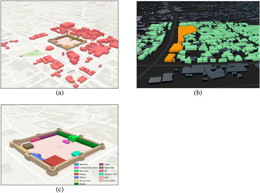
Figure 5. 3D GIS model showing the heritage asset. (A) and (B) with the surrounding urban fabric (C) details of the asset.
5 Discussion
The usage of 3D GIS brings enhanced sustainability to UNESCO-protected archeological sites within Al-Ahsa while providing better cultural heritage research opportunities. This research highlights how urban planning regulations must operate continually with heritage conservation strategies for essential development. Qasr Ibrahim serves as an example that illustrates how detailed structural and spatial analyses demonstrate the system’s power to link historic value and functional urban design. The traditional blend of Islamic architectural art is observed at Qasr Ibrahim while offering practitioners valuable insights into combining historical meaning with contemporary preservation methods for areas with urban interdependencies (Yazdani, 2024; Vacca et al., 2018).
The study follows international standards for restoration practices in France and Italy since its inclusion of tailored real-time spatial analysis outpaces these by creating urban-specific solutions. The structured database described in the results functions as baseline data to support ongoing conservation efforts and enables decision-making systems similar to Canadian knowledge integration programs (Bay et al., 2022). By developing web map systems, users now have access to attribute data and spatial analysis tools, thus showing how research results can work effectively in real-world implementations.
The unique strengths of this approach become apparent when compared to global studies. The Greek study (Yazdani, 2024) focuses on natural disaster risk evaluation, whereas Al-Ahsa’s framework demonstrates adaptations for urbanization effects, which enable richer threat mitigation responses. The Turkish program for disaster management prioritizes educational design while displaying no resemblance to Al-Ahsa’s system approach for web-based disaster preparedness dissemination and overall operational practice outreach to the public.
This study proves that the Al-Ahsa framework maintains global benchmarks yet outperforms competitors through its distinctive attention to urbanization impact along with public interaction and essential adaptability features. This research shows how maintaining consistency and innovation supports both proven excellence and growth potential dedicated to worldwide sustainable cultural site management practices. A successful 3D GIS application for heritage site conservation emerges from studies performed by Saygi et al. (2018) through integrating architectural and historical records into 3D GIS to boost preservation choices in Italy. Spatial and structural data integration in this current research allows stakeholders to make educated decisions for conserving Al-Ahsa’s heritage assets.
Furthermore, 3D GIS assessment techniques for natural disaster risks to heritage sites in Greece are outlined by Yazdani (2024). The system in Greece performs spatial analysis to reveal potential threats which delivers information that enables preventative actions. The current study tracks comparable patterns by first mapping out Al-Ahsa’s archeological site’s vulnerability to environmental stressors and urban development challenges to ensure effective protective measures can be developed. Research in Turkish archeology through hypothetical reconstructions (Keep, 2022) aligns with Chinese investigations of UNESCO sites (Li et al., 2022), demonstrating how 3D GIS functions in heritage education and public outreach. The web-based mapping component of the existing system enhances community engagement by providing access through Google Earth-like interfaces.
Finally, the findings of Rinaudo et al. (2007) highlight the importance of combining HBIM and GIS technology to improve the accessibility and management of cultural heritage sites. The system’s 3D geographic information system functionality aligns with these research findings, supporting both documentation processes and fostering community-wide participation.
6 Limitations to this study
The designed system specifically adapts to meet the specialized documentation requirements of managing heritage sites in the Al-Ahsa region. The system operates with certain crucial constraints. The system demonstrates proven success in Al-Ahsa yet needs additional optimization for dealing with larger datasets and various heritage sites possessing complex characteristics for future scalable applications. Expanding the system through wider heritage applications will face obstacles from both processing extensive datasets and maintaining high-resolution 3D models and resource requirements.
The framework used in this study has several specific weaknesses but produces an effective framework for assessing design studio spaces. This approach enables practical post-occupancy assessments yet requires additional adaptability to meet the requirements of various project settings. Formally structured protocols designed for system interaction may increase the platform’s potential to serve as a viable solution for different implementations.
In addition, the system achieves heritage documentation through 3D GIS, yet continued updates and maintenance will determine its lasting usability because of technological progress. Future research should focus on developing automated methods to enhance data collection and processing operations, thereby improving operational effectiveness. The system’s successful implementation requires Heritage managers and policymakers to receive training along with stakeholder engagement in order to adopt the system properly.
7 Conclusion
The proposed 3D information system for heritage management offers significant benefits by enhancing the preservation and utilization of cultural resources. By integrating a diverse range of data related to various management and conservation aspects, the system provides a comprehensive framework that supports informed decision-making. This holistic approach enables heritage managers to identify potential issues and develop targeted strategies for preservation, ensuring that cultural heritage is effectively protected. The 3D visualization capabilities allow for a deeper understanding of spatial relationships, facilitating intuitive analyses of the structural integrity and historical significance of heritage sites.
Additionally, the inclusion of a web map serves as a vital tool for community engagement, raising awareness about the importance of heritage conservation and fostering a sense of ownership among local residents. This engagement is crucial for garnering support for conservation initiatives. This paper provides an important framework for standardized procedures for heritage documentation that organizations using cultural heritage preservation services can use as a practical means of adoption. The system architecture is flexible and can be adapted to different regions to create a scalable digital heritage management system.
In practice, the system can be applied to monitor the condition of heritage sites, plan restoration projects, and conduct impact assessments for proposed developments. By utilizing this innovative system, heritage managers can implement proactive measures that not only safeguard architectural heritage but also promote cultural appreciation and community involvement, ultimately contributing to the sustainable management of these invaluable resources.
Future efforts should focus on combining AI-driven analytical approaches with automation technology for improving the efficiency of risk evaluations and restoration planning. The system must develop its augmented reality (AR) and virtual reality (VR) features to provide researchers with comprehensive interactive possibilities for heritage exploration.
Data availability statement
The raw data supporting the conclusions of this article will be made available by the authors, without undue reservation.
Author contributions
ME: conceptualization, data curation, formal analysis, investigation, methodology, project administration, resources, software, supervision, validation, visualization, writing–original draft, and writing–review and editing. AS: formal analysis, investigation, methodology, visualization, and writing–review and editing. MA: conceptualization, formal analysis, methodology, resources, software, validation, and writing–review and editing. DS: conceptualization, data curation, formal analysis, methodology, resources, and writing–review and editing. RK: conceptualization, data curation, methodology, software, supervision, and writing–original draft.
Funding
The author(s) declare that financial support was received for the research, authorship, and/or publication of this article. The authors would like to acknowledge that this research work was partially funded by Kingdom University, Bahrain, from the research grant number KU–SRU-2024–11.
Conflict of interest
The authors declare that the research was conducted in the absence of any commercial or financial relationships that could be construed as a potential conflict of interest.
Generative AI statement
The author(s) declare that no Generative AI was used in the creation of this manuscript.
Publisher’s note
All claims expressed in this article are solely those of the authors and do not necessarily represent those of their affiliated organizations, or those of the publisher, the editors and the reviewers. Any product that may be evaluated in this article, or claim that may be made by its manufacturer, is not guaranteed or endorsed by the publisher.
References
Agapiou, A., Lysandrou, V., Themistocleous, K., and Hadjimitsis, D. G. (2016). Risk assessment of cultural heritage sites clusters using satellite imagery and GIS: the case study of Paphos District, Cyprus. Nat. Hazards J. Int. Soc. Prev. Mitig. Nat. Hazards 83 (1), 5–20. doi:10.1007/s11069-016-2211-6
Alfelali, M. A. (2024). The emergence and consolidation of heritage conservation in Mecca, Saudi Arabia, 1955–2021 (PhD thesis). (Tyne, United Kingdom; Tyne, United Kingdom). Available online at: http://hdl.handle.net/10443/6277.
Alqahtany, A., and Aravindakshan, S. (2022). Urbanization in Saudi Arabia and sustainability challenges of cities and heritage sites: heuristical insights. J. Cult. Herit. Manag. Sustain. Dev. 12 (4), 408–425. doi:10.1108/JCHMSD-07-2020-0108
Baik, A. H. (2021). Heritage building information modelling for implementing UNESCO procedures: challenges, potentialities, and issues. 1st ed. Routledge. (Routledge, an imprint of Taylor & Francis Group, headquartered in Abingdon, Oxfordshire, United Kingdom) Available online at: https://www.routledge.com/Heritage-Building-Information-Modelling-for-Implementing-UNESCO-Procedures-Challenges-Potentialities-and-Issues/Baik/p/book/9780367510718?srsltid=AfmBOor5ruywmi6EnGp7VG4BeVZ3RNcMkP7vsV6kui7rqp1pK6aKJkV7.
Bay, M. A., Alnaim, M. M., Albaqawy, G. A., and Noaime, E. (2022). The heritage jewel of Saudi Arabia: a descriptive analysis of the heritage management and development activities in the At-Turaif district in Ad-Dir’iyah, a World Heritage Site (WHS). Sustainability 14 (17), 10718. doi:10.3390/su141710718
Biljecki, F., Ledoux, H., Stoter, J., and Vosselman, G. (2016). The variants of an LOD of a 3D building model and their influence on spatial analyses. ISPRS J. Photogrammetry Remote Sens. 116, 42–54. doi:10.1016/j.isprsjprs.2016.03.003
Branchini, A. (2015). Tourism and its economic impact in Italy: a study of industry concentration and quality of life M.S. thesis. Columbia University. doi:10.7916/D8N878Z6
Campanaro, D. M., Landeschi, G., Dell’Unto, N., and Leander Touati, A.-M. (2016). 3D GIS for cultural heritage restoration: a ‘white box’ workflow. J. Cult. Herit. 18, 321–332. doi:10.1016/j.culher.2015.09.006
Colucci, E., Iacono, E., Matrone, F., and Ventura, G. M. (2023). The development of a 2D/3D BIM-GIS web platform for planned maintenance of built and cultural heritage: the MAIN10ANCE project. International Archives of Photogrammetry. Remote Sens. Spatial Inf. Sci. XLVIII-M-2, 433–439. doi:10.5194/isprs-archives-XLVIII-M-2-2023-433-2023
D'Urso, M. G., Corsi, E., Nemeti, S., and Germani, M. (2017). From excavations to web: a GIS for archaeology. International Archives of Photogrammetry. Remote Sens. Spatial Inf. Sci. XLII-5/W1, 219–226. doi:10.5194/isprs-archives-XLII-5-W1-219-2017
Elfadaly, A., Shams eldein, A., and Lasaponara, R. (2020). Cultural heritage management using remote sensing data and GIS techniques around the archaeological area of ancient jeddah in jeddah city, Saudi Arabia. Sustainability 12 (1), 240. doi:10.3390/su12010240
Ettorre, B., Daldanise, G., Giovene di Girasole, E., and Clemente, M. (2023). Co-planning port–city 2030: the InterACT approach as a booster for port–city sustainable development. Sustainability 15 (21), 15641. doi:10.3390/su152115641
Fiorini, G., Friso, I., and Balletti, C. (2022). A geomatic approach to the preservation and 3D communication of urban cultural heritage for the history of the city: the journey of Napoleon in Venice. Remote Sens. 14 (14), 3242. doi:10.3390/rs14143242
Garzulino, A., Borgarino, M. P., and Del Curto, D. (2021). When GIS joins the conservation management plan of a 20th-century architectural heritage. Sustainability 13 (7), 3881. doi:10.3390/su13073881
Ginzarly, M., Houbart, C., and Teller, J. (2018). The Historic Urban Landscape approach to urban management: a systematic review. Int. J. Herit. Stud. 25, 999–1019. doi:10.1080/13527258.2018.1552615
Giuffrida, D., Mollica Nardo, V., Neri, D., Cucinotta, G., Calabrò, I. V., Pace, L., et al. (2021). A multi-analytical study for the enhancement and accessibility of archaeological heritage: the churches of San Nicola and San Basilio in Motta Sant’Agata (RC, Italy). Remote Sens. 13 (18), 3738. doi:10.3390/rs13183738
González, J., Figueiredo, K., Hammad, A. W. A., Tam, V. W. Y., Haddad, A. N., and Illankoon, C. (2024). Heritage BIM (HBIM) applied in emergency scenarios: a case study of the National Museum in Brazil. Int. J. Constr. Manag., 1–15. doi:10.1080/15623599.2024.2408183
Huang, Y. (2024). Bibliometric analysis of GIS applications in heritage studies based on Web of Science from 1994 to 2023. Herit. Sci. 12 (57), 57. doi:10.1186/s40494-024-01163-y
Ibtissem, L., Lamia, L., Lazhar, G., and Youcef, L. (2024). Comparative spatio-temporal dynamics of urban sprawl in Algerian cities Skikda and Tébessa (1985–2024) using GIS and Landsat imagery. J. Contemp. Urban Aff. 8 (2), 404–420. doi:10.25034/ijcua.2024.v8n2-7
Karpinskyi, Y., Lazorenko, N., Kin, D., Maksymova, Y., Nesterenko, O., Zhao, H., et al. (2024). Geoinformation support of the decision-making support system for the reconstruction of cultural heritage objects. Int. J. Conservation Sci. 15, 119–128. doi:10.36868/IJCS.2024.SI.10
Keep, T. (2022). The Mernda VR project: the creation of a VR reconstruction of an Australian heritage site. J. Comput. Appl. Archaeol. 5 (1), 238–254. doi:10.5334/jcaa.91
Kumar, A., Chhabra, D., and Sharma, V. (2023). The impact of tourism on the preservation of UNESCO cultural heritage sites in India. Available online at: https://www.researchgate.net/publication/376642372_The_Impact_of_Tourism_on_the_Preservation_of_UNESCO_Cultural_Heritage_Sites_in_India_2023.
Li, Y., Zhao, L., Chen, Y., Zhang, N., Fan, H., and Zhang, Z. (2022). 3D LiDAR and multi-technology collaboration for preservation of built heritage in China: a review. Int. J. Appl. Earth Observation Geoinformation 113, 103156. doi:10.1016/j.jag.2022.103156
López, F. J., Lerones, P. M., Llamas, J., Gómez-García-Bermejo, J., and Zalama, E. (2018). A review of heritage building information modeling (H-BIM). Multimodal Technol. Interact. 2 (2), 21. doi:10.3390/mti2020021
Mahdy, H. (2016). The socio-cultural aspects of conservation: notes on the effect of modernization in the Arab region. Available online at: https://www.academia.edu/34527608/The_Socio_Cultural_Aspects_of_Conservation_Notes_on_the_Effect_of_Modernization_in_the_Arab_Region.
Mayaleh, A., and Hamamra, B. (2024). Instruments of resilience: cultural tourism in Palestinian resistance. Int. J. Herit. Stud. 30 (9), 1103–1119. doi:10.1080/13527258.2024.2369553
Mazzetto, S., and Vanini, F. (2023). Urban heritage in Saudi Arabia: comparison and assessment of sustainable reuses. Sustainability 15 (12), 9819. doi:10.3390/su15129819
Monchetti, S., Betti, M., Borri, C., Gerola, C., Matta, C., and Francalanci, B. (2023). Insight on HBIM for Conservation of Cultural Heritage: The Galleria dell’Accademia di Firenze. Heritage 6 (11), 6949–6964. doi:10.3390/heritage6110363
Mousazadeh, H., Ghorbani, A., Azadi, H., Almani, F. A., Zangiabadi, A., Zhu, K., et al. (2023). Developing sustainable behaviors for underground heritage tourism management: the case of Persian qanats, a UNESCO world heritage property. Land 12 (4), 808. doi:10.3390/land12040808
Özer, B., and Yalçıner Ercoşkun, Ö. (2024). Integration of rs and GIS in assessing flood risk: a case study on istanbul - esenyurt. J. Contemp. Urban Aff. 8 (1), 57–78. doi:10.25034/ijcua.2024.v8n1-4
Quintilla-Castán, M. (2023). “3D GIS information system for the inventory of the Mudejar heritage in Aragon: architecture and territory,” in Lecture notes in networks and systems: proceedings of the 3rd international and interdisciplinary conference on image and imagination. Springer International Publishing, 819–827. doi:10.1007/978-3-031-25906-7_90
Rinaudo, F., Agosto, E., and Ardissone, P. (2007). “GIS and Web-GIS, commercial and open source platforms: general rules for cultural heritage documentation,” in Proceedings of the 21st international CIPA symposium (Athens, Greece), 625–630. Available online at: https://www.researchgate.net/publication/228618101_Gis_and_WebGis_Commercial_and_Open_Source_Platforms_General_Rules_for_Cultural_Heritage_Documentation.
Rjoub, A., and Al-Azhari, W. (2011). Documenting the architectural heritage resources in Mafraq Governorate using geographic information system (GIS). Available online at: https://www.researchgate.net/publication/266206724_Documenting_the_Architectural_Heritage_Resources_in_Mafraq_Governorate_Using_Geographic_Information_System_GIS.
Salvemini, M. (1999). “The infrastructure for spatial information in the European Community vs. regional SDI: the shortest way for reaching economic and social development,” in 9th united nations regional cartographic conference for asia and the pacific, economic and social commission for asia and the pacific. Available online at: https://unstats.un.org/unsd/geoinfo/rcc/docs/rcca9/ip/9th_UNRCCA_econf.99_IP12.pdf.
Saygi, G., Agugiaro, G., and Hamamcioglu-Turan, M. (2018). Behind the 3D scene: a GIS approach for managing the chronological information of historic buildings. Multimodal Technol. Interact. 2 (2), 26. doi:10.3390/mti2020026
Soler, F. J., Melero, F. J., and Luzón, M. V. (2017). A complete 3D information system for cultural heritage documentation. J. Cult. Herit. 23, 49–57. doi:10.1016/j.culher.2016.09.008
Stylianidis, E., Evangelidis, K., Vital, R., Dafiotis, P., and Sylaiou, S. (2022). 3D documentation and visualization of cultural heritage buildings through the application of geospatial technologies. Heritage 5 (4), 2818–2832. doi:10.3390/heritage5040146
Thomas, K. (2023). Biocultural mapping: unpacking the myth of an unsuitable country in the arid zone, willandra lakes region world heritage area, Australia. Environ. Syst. Res. 12, 23. doi:10.1186/s40068-023-00309-4
Vacca, G., Fiorino, D. R., and Pili, D. (2018). A spatial information system (SIS) for the architectural and cultural heritage of sardinia (Italy). ISPRS Int. J. Geo-Information 7 (2), 49. doi:10.3390/ijgi7020049
Wang, X., Gong, Y., Myers, D., and Wang, S. (2021). ARCHES dunhuang: heritage inventory system for conservation of grotto resources on the gansu section of the silk road in China. International archives of photogrammetry. Remote Sens. Spatial Inf. Sci. XLVI-M-1, 837–843. doi:10.5194/isprs-archives-XLVI-M-1-2021-837-2021
Wu, J., Xiao, Y., Zhu, L., and Cheng, S. (2024). The identification of historic plant landscape characteristics and conservation strategies for longevity hill based on the WSL monoplotting tool. Land 13 (8), 1255. doi:10.3390/land13081255
Yang, X., Grussenmeyer, P., Koehl, M., Macher, H., Murtiyoso, A., and Landes, T. (2020). Review of built heritage modelling: integration of HBIM and other information techniques. J. Cult. Herit. 46, 350–360. doi:10.1016/j.culher.2020.05.008
Yazdani, S. (2024). “Virtual reconstruction and preservation of heritage sites using historical building information modelling (HBIM) through a case study,” in MSc advanced construction technologies and BIM EF1100 dissertation proposal. Available online at: https://www.researchgate.net/publication/383915205_Virtual_Reconstruction_and_Preservation_of_Heritage_Sites_Using_Historical_Building_Information_Modelling_HBIM_through_a_Case_Studyhttps://www.researchgate.net/publication/383915205_Virtual_Reconstruction_and_Preservation_of_Heritage_Sites_Using_Historical_Building_Information_Modelling_HBIM_through_a_Case_Study.
Keywords: urban heritage, cultural heritage management, archeological site, 3D GIS, data management systems
Citation: Ezz MS, Soliman AM, Aldelgawy M, Salem DAH and Khalil R (2025) Utilizing 3D GIS for the sustainable management of UNESCO World Heritage Sites in Saudi Arabia. Front. Built Environ. 11:1550124. doi: 10.3389/fbuil.2025.1550124
Received: 22 December 2024; Accepted: 24 February 2025;
Published: 18 March 2025.
Edited by:
Chen Ren, Southeast University, ChinaReviewed by:
Hourakhsh Ahmadnia, Alanya University, TürkiyeAhmet Cilek, Çukurova University, Türkiye
Copyright © 2025 Ezz, Soliman, Aldelgawy, Salem and Khalil. This is an open-access article distributed under the terms of the Creative Commons Attribution License (CC BY). The use, distribution or reproduction in other forums is permitted, provided the original author(s) and the copyright owner(s) are credited and that the original publication in this journal is cited, in accordance with accepted academic practice. No use, distribution or reproduction is permitted which does not comply with these terms.
*Correspondence: Mohamed Salah Ezz, ZHJtb2hhbWVkc2FsYWhAb2MuZWR1LnNh