 Raphaela Edler
 Georg Glasze
 Katrin Kinzelbach
 Blake Byron Walker
- 1Friedrich-Alexander-Universität Erlangen-Nürnberg, Institute of Geography, Erlangen, Germany
- 2Friedrich-Alexander-Universität Erlangen-Nürnberg, Institute of Political Science, Erlangen, Germany
This paper investigates the use and potential role of satellite remote sensing (RS) data in documenting conflict incidents and related human rights violations. In particular, we scrutinized the methods applied by researchers and human rights practitioners as well as the characteristics of those human rights violations that were documented on the basis of analysis of remote sensing data. To this end, we reviewed 901 articles, out of which we chose 48 articles that comprised 51 empirical studies for an in-depth review analysis. The articles included in our literature corpus were published between 2006 and 2023. Our review of the studies focused on the following aspects: research organisations, geographies of the empirical studies, spatial resolution of RS data, methods used in empirical studies, validation practices, reported challenges. Despite the salience of human rights violations in recent history and the adoption of digital data-driven investigations in this context, we find that an increased focus on human rights is not detectable in RS-based research. Employing a critical remote sensing perspective, we show that a few conflicts dominate the attention of RS analyses, while other conflicts remain unobserved. As most studies (still) rely on visual interpretation, which requires very high-resolution data, we detect widespread dependencies on commercial providers. A perceptible rise in the use of machine learning approaches for documenting conflicts goes hand in hand with a similar increase in the involvement of academic researchers. The latter’s involvement changes validation processes to the extent that these processes shift towards relying exclusively on remote data instead of local human rights knowledge. Our findings highlight the untapped potential for interdisciplinary research and emphasize the need for more collaborative work, conjoining remote sensing and human rights expertise.
1 Introduction
Data-driven approaches increasingly complement the traditional reliance on witness testimonies in human rights investigations (Dubberley et al., 2020; Murray et al., 2022). This shift in documentation practices, powered by digital data from satellites and user-generated content on social media, unlocks a realm of possibilities for exploration, imbuing the documentation of human rights violations with promising new potential. For example, digital data enables the reconstruction of and reporting on events in difficult-to-access regions, such as conflict zones. They are therefore relevant for the work of human rights practitioners, who monitor the targeting of civilians and attacks on protected sites as well as other violations of human rights (AAAS; Marx, 2013; Marx and Goward, 2013). Given these realities, we hypothesise that remote sensing (RS) researchers pay increasing attention to human rights. To examine this hypothesis, this paper provides the first comprehensive review of articles in which satellite RS data were used as a primary data source for documenting events in armed conflicts, including potential human rights violations. The publishing period considered ranges from 2006 to 2023. By reviewing a systematically compiled, comprehensive corpus of articles with empirical studies, we contribute to an ongoing debate about the challenges of using RS data in human rights documentation, accountability processes, and advocacy.
Data used in digital conflict documentation, including satellite data, videos, photos, or text material–also often referred to as open-source information–originate from a variety of contexts and are generated via a plethora of distinct methods. For example, reports are often available in text formats or in a table overview, while user-generated content is available as text, video, or photo content, and RS data are stored in a raster format, accessible on commercial or public platforms. These characteristics and production contexts inform not only different possible uses but also varying risks of manipulation. Additionally, the listed data types differ in their metadata’s degree of detail, i.e., the level of information comprised in the data that describe the data. Particularly in cases where no metadata are available, the quality of the data and its trustworthiness decrease (Ulrich et al., 2022). A transparent and nuanced perspective on the type of open-source data, their contexts, and the available metadata is, therefore, indispensable. Furthermore, information about the digital data’s context is also relevant in terms of accountability processes, where transparency and reproducibility are key, as elaborated on in the 2022 Berkeley Protocol under the section that focuses on the chain of custody (United Nations and University of California, Berkeley, 2022).
Murray et al. (2022) catalogue the differences between distinct types of open-source data used in human rights contexts, categorizing the data into primary, secondary, aggregated, and unique data objects. While this categorization provides an essential first step towards understanding the broad scope of open-source data, a single-axis classification of this kind risks overseeing crucial differences in dependencies on specific providers, the availability of data, the detail of information it comprises, and potentially related misinformation or disinformation. Several scholars have examined some of these data characteristics for user-generated data in digital human rights research (Koenig, 2019; McPherson et al., 2019; Sacco and Bossio, 2015), while dependencies on specific providers and the availability of satellite RS data in human rights analyses have been widely neglected as subjects of inquiry. One reason for this negligence can be the perception of satellite data as neutral and objective (Marx and Loboda, 2013; Quinn et al., 2018). For RS analyses to be admitted as evidence in legal accountability processes, not only the content but also the credibility of the source must be assessed (United Nations and University of California, Berkeley, 2022). Therefore, this review covers both the content of the empirical research as well as the circumstances under which it was produced. We recognise the relevance of RS data for conflict documentation and contribute to the debate by examining specific RS practices in the digital documentation of conflicts, which may reveal patterns or characteristics of human rights violations. With this, we contribute to an ongoing debate about the use of RS data in human rights research on armed conflicts.
2 Data and methods
This study uses a structured review approach to summarise key themes and methods in the selected body of literature. Given the interdisciplinary nature of the subject of inquiry, we did not limit ourselves to one discipline. During conflicts, the risk that a broader range of human rights violations are committed in a systematic and widespread manner increases (Poe and Tate, 1994), which is why we used keywords related to armed conflicts.
Figure 1 depicts our selection process to identify relevant literature; we used a keyword search of terms such as RS, human rights, armed conflict, International Humanitarian Law (IHL), and Human Rights Law (HRL) on 28 literature databases (more details on the keywords and the databases in Supplementary Appendix A), reviewing and classifying 901 articles. The articles were categorised into (I) empirical studies with an RS analysis of events in conflict zones, (II) research focusing on theoretical aspects of human rights, (III) RS research focusing on legal issues of digital geodata and human rights, and lastly, (IV) all other articles not directly related to this review. Articles were reviewed in depth if they met the following criteria: (I) the articles include an empirical study, (II) RS data are a primary source of information in the analysis, and (III) the study mentions human rights. We ended our search on 26 January 2024. In total, 48 articles met the selection criteria. We identified 51 empirical case studies across these 48 articles, which were consequently selected for an in-depth review analysis. The other articles were considered for the contextualisation and discussion of the review results (see Supplementary Appendix B for more details).
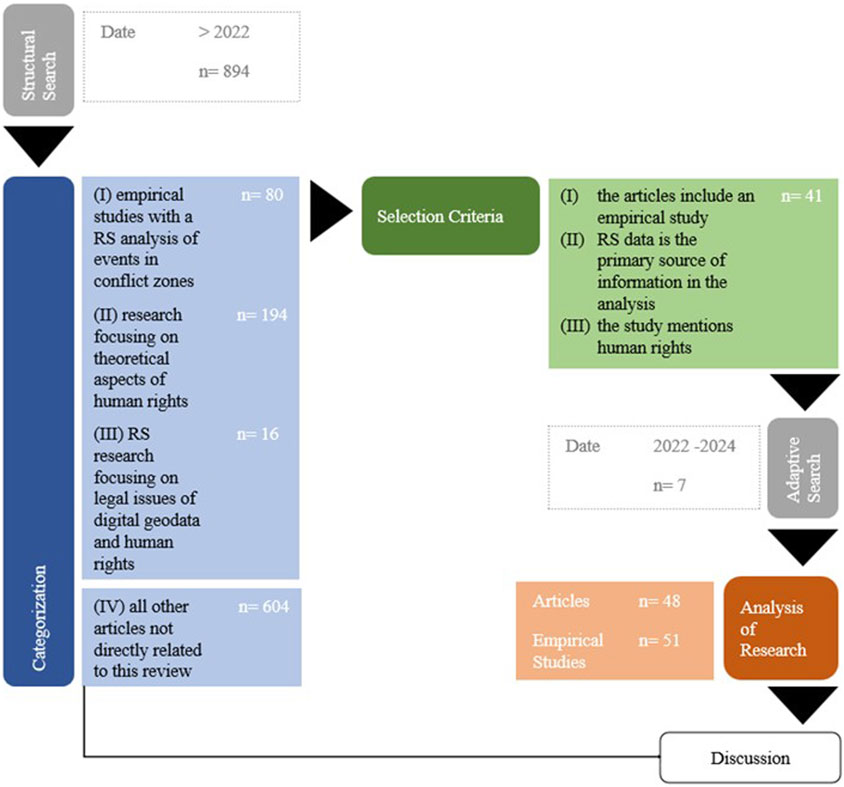
Figure 1. Selection process to identify relevant literature.
For the in-depth analysis, we reviewed the empirical case studies according to their research organisation(s), the geography of the conflict events described in the empirical studies, the spatial resolution, the methods applied, with a focus on machine learning (ML) algorithms, as well as the validation process and overall reported challenges.
2.1 Research organisation(s)
For the categorisation of the research organisation(s), we wanted to understand the context in which the reviewed articles were produced. Therefore, we differentiated between articles originating from universities, research organisations such as the American Association for the Advancement of Science (AAAS), the United Nations (UN), the Red Cross, and various non-governmental organisations (NGO).
2.2 Geographies of the empirical studies
To display the geographical locations of the conflict events described in the empirical studies, we used country codes, following the norm 3166 from the International Organisation for Standardisation (ISO) (ISO, 2025). The decision to use country codes is informed by the different spatialities of conflicts, which are difficult to categorise on a map. Country codes were the most uniform classification category available. We acknowledge the complex setting of conflict events and geopolitical tensions in country codes, such as the ISO standard, where changes in country borders and contested territories may not always be accurate and well represented.
2.3 Spatial resolution of RS data
The spatial detail with which conflict events and potential human rights violations can be documented via RS data largely depends on the spatial resolution of the data. Following Deroin et al. (2011) we define very high spatial resolution as under 2 m, high spatial resolution as 2–30 m, medium spatial resolution as between 30 and 100 m, low spatial resolution as 100–1,000 m, and very low spatial resolution as above 1,000 m. Many reviewed empirical studies comprise more than one data type and, therefore, different spatial resolution categories. We thus categorised each data type per empirical study. This means that the number of counts in is higher than the number of empirical studies.
The spatial resolution of RS data depends on the data providers: Commercial providers offer data with higher spatial resolution compared to public providers. Therefore, we also categories the provider of the data. We define commercial providers as entities from which the data can be obtained only after payment. This is the case for data providers such as Maxar, Planet, or Digital Globe. By contrast, public providers are providers whose data are openly accessible. For example, they include the United States Geological Survey (USGS) from NASA or the Copernicus data provider from the European Space Agency (ESA). We use the term public, even though publicly available data can also be non-public in countries where websites are censored, with data providers being banned for political reasons. The category public provider may be used differently in other reviews that include research from areas impacted by internet censorship. The classification of providers into commercial and public needs further nuance since commercial providers often offer pro bono access to their data with specific deals, contracts, or Application Programming Interfaces (API)s. Commercial providers argue that researchers and NGOs have “a lot on their plates and a gaping hole in their budgets” (EOS Data Analytics, 2023), and companies such as Planet want NGOs to unlock the power of satellite data (Planet, 2024), which is why they offer selected researchers and NGOs access to their databases. To account for these specific circumstances, we included the category commercial (without costs) in our review analysis. Further, some studies used a mix of data, resulting in a category called commercial (without costs) and public.
2.4 Methods used in empirical studies
Most empirical studies employed multiple approaches, we categorised each approach once; consequently, the number of approaches exceeds the number of empirical studies. To understand what RS observations can point to linkages of human rights violations, the respective observations were categorised, for example, into land cover, land use change, damage or fire, among others. We also wanted to understand which specific human rights violations these categories comprise more deeply. However, in most cases, human rights were not referenced clearly, hindering accurate categorization.
Since an increase in ML approaches has been perceptible in recent years across other research areas using digital data (Pugliese et al., 2021), we were particularly interested in understanding whether this trend is also discernible in conflict documentation and the identification of potential human rights violations with digital RS data. We categorised the empirical studies into those that use and those that do not use ML approaches. Since many studies applied several methods, we categorised each method separately. Consequently, counts outnumbered studies.
2.5 Validation practices
Due to the specific context of conflicts, accessibility and ground data are often lacking (FEWS NET, 2024; Raleigh et al., 2023). It is therefore particularly interesting to examine how the studies comprised in our corpus dealt with this difficulty of finding (alternative) ways to validate results. We categorised which data were used for the validation process in the following way: Ground data validating RS analysis in this context refers to data acquired in situ, including interviews, measurements, videos, and photos sent by witnesses. Remote data validating RS analyses are data without contact with actors on the ground, which can consist of data collected via visual image interpretation with satellite data, for example. Other data validating RS analysis denotes data collected for other purposes but fitting the criteria for validating results, including open-source information, such as videos, photos, and posts from social media accounts or other accessible information. Ground data and other data validating RS analysis is a mix of ground data and other data described above. We added the category remote data validating hints from direct sources because, throughout the review process, we understood that RS data were used to validate claims from other sources, such as local contacts. We used the category unclear for cases that lacked a discernible validation process.
2.6 Reported challenges
Due to the novelty of this field of research, we also classified the reported challenges in the studies into remote, human, machine, data, monetary, or not mentioned. Remote challenges are cases in which the researchers declare that they had difficulty accessing local knowledge about the study area. In line with Lillesand et al. (2002), we consider it important that the given researcher has knowledge of the phenomenon and geographic region under investigation. We therefore foreground the declared difficulties in accessing information from on-the-ground sources in crisis countries, which are complex and sometimes unfamiliar environments for the researchers. Related but different are human challenges. We used the category human challenges when the researchers reflected on their positionality while processing the data and model, indicating potential uncertainties that can arise because of this positionality. Further, we use the category method challenges when the researchers remark on the possibility that an algorithm or a model used in their analysis generated inaccurate results. Connected to this aspect is the category data challenge, which marks cases where data availability was limited. We also used this category when information was missing, for example, the date in a Google Web Map Service (WMS). Economic challenges highlight cases where the researchers of the empirical study state that they could not run a particular analysis due to financial constraints.
The visualisation of the categories was undertaken with Python 3.10.9 in a Jupyter Environment 4.0.11 and QGIS 3.38.0.
For the discussion, the interdisciplinary scope of this review, along with our goal of unpacking both the context and content of the examined studies, necessitates an evaluation and discussion of the results through a critical RS lens. Using critical RS to review results involves not only interpreting the data used and methods applied but also reflecting on the socio-political contexts in which the production, analysis, and application of the empirical study data are embedded. This relational evaluation allows us to shed light on methods and practices of injustice, evaluate the engagement with situated knowledge from the ground, and understand the development of practices in the political and economic production contexts of RS (Bennett et al., 2022a).
3 Results of the reviewed categories
In the following, we will present the results under themes: (I) research organisation(s), (II) geographies of the empirical studies, (III) spatial resolution of RS data, (IV) methods used in empirical studies with a focus on machine learning (ML) algorithms, (V) validation practices, and (VI) reported challenges.
3.1 Research organisation(s)
The articles in our corpus were published between 2006 and 2023 and vary from reports and journal articles to conference papers. Figure 2 shows a time series of the selected empirical studies and their publishing organisations. What emerges is the collaborative manner of this research field, with four of the categories, namely Academic & Gov & Other, Academic & NGO, Academic & Other, and Other & NGO, containing research that was produced by more than one organisation. Additionally, NGOs played an important role until 2014; from then on, the share of Academic and collaborative work, including Other, increased.
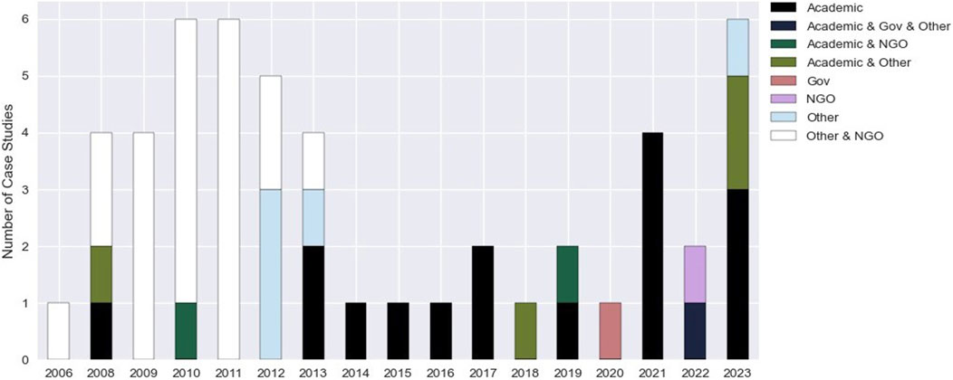
Figure 2. Publishing organization of empirical studies over time.
3.2 Geographies of the empirical studies
Figure 31 illustrates the geographical locations of the conflict events described in the empirical studies.
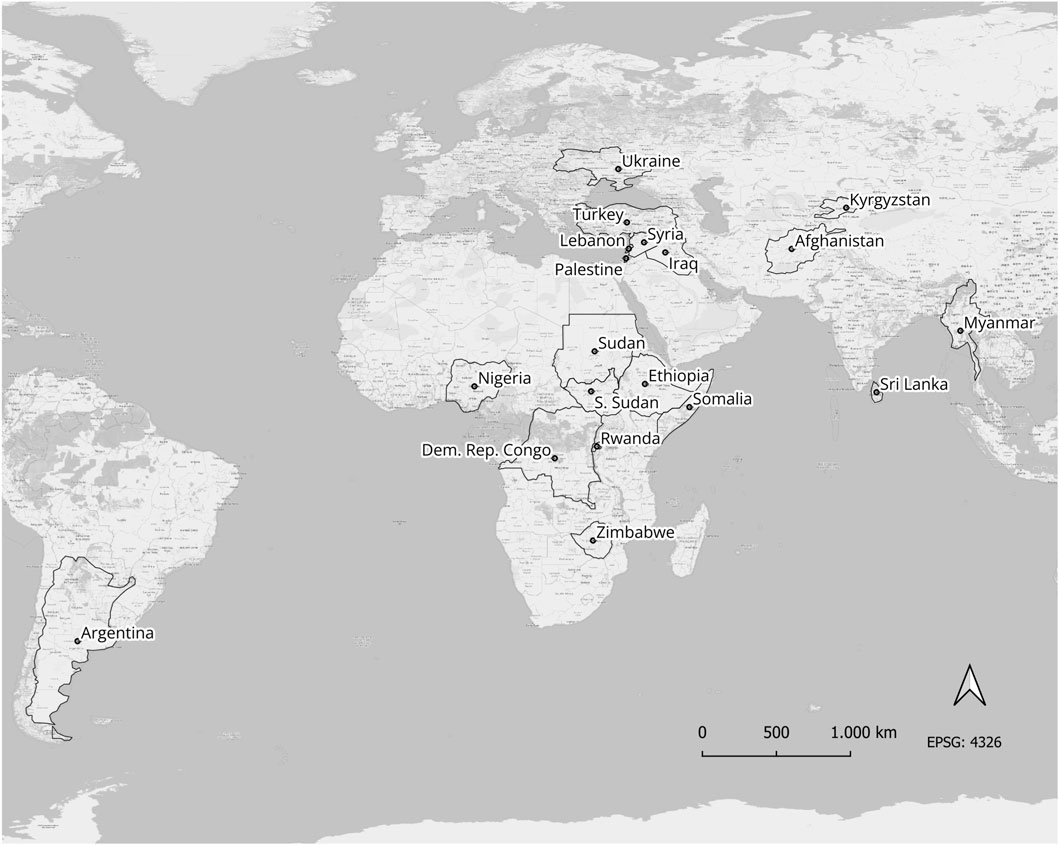
Figure 3. Countries investigated in the empirical studies categorised according to ISO Norm 3166.
To identify reporting trends, we plotted the number of investigations per country. In Figure 4, Ukraine is the country examined most often, followed by Sudan, Myanmar, Syria, and Nigeria.
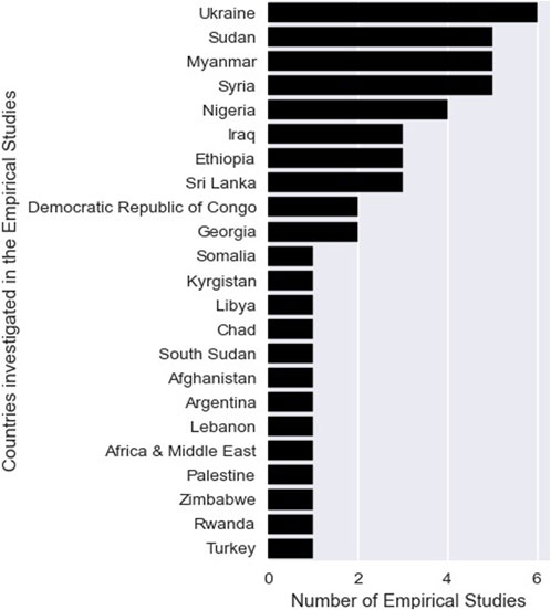
Figure 4. Number of empirical studies per country.
3.3 Spatial resolution of RS data
The spatial resolution of the data used over time is visualised in Figure 5. We observe that the focus was on very high spatial resolution data during the first years of the period under consideration, whereas in recent years, more high spatial resolution data were used.
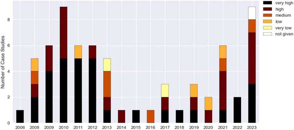
Figure 5. Spatial resolution data of empirical studies over time.
Figure 6 shows a stacked bar plot of empirical studies per year and their data origins in different colours. We observe that until 2012, data used in the empirical studies stemmed predominantly from commercial providers, whereas in 2023, the majority of studies sourced data from at least one public provider.
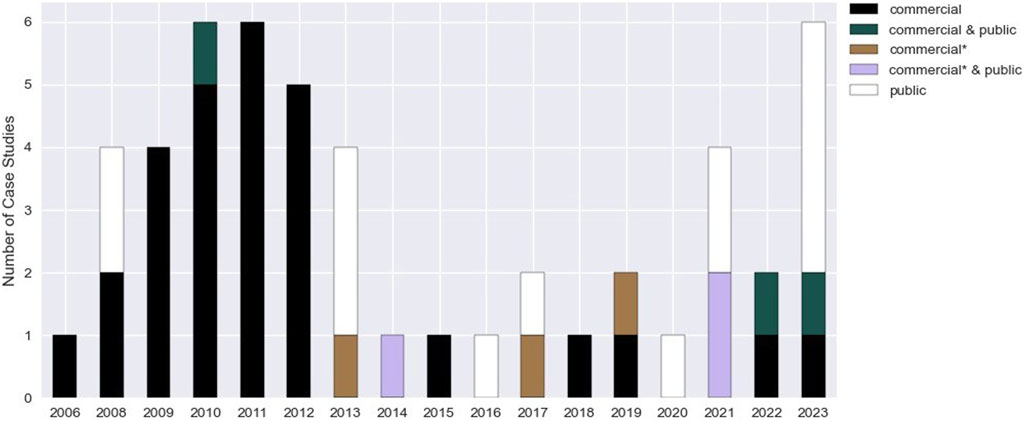
Figure 6. RS provider category in empirical studies over time.
3.4 Methods used in empirical studies
The trend of empirical studies using ML versus non-ML approaches over time is visualised in Figure 7. The figure shows that, over time, there has not been a clear trend towards ML approaches. Of all studies applying ML approaches, ten used supervised algorithms, and one used an unsupervised approach. Most studies used more than 1 ML type: the majority used Random Forests (three times), Support Vector Machines (two times), and Neural Networks (two times). All other types only occurred once, such as Maximum Likelihood or Minimum Distance, among others.
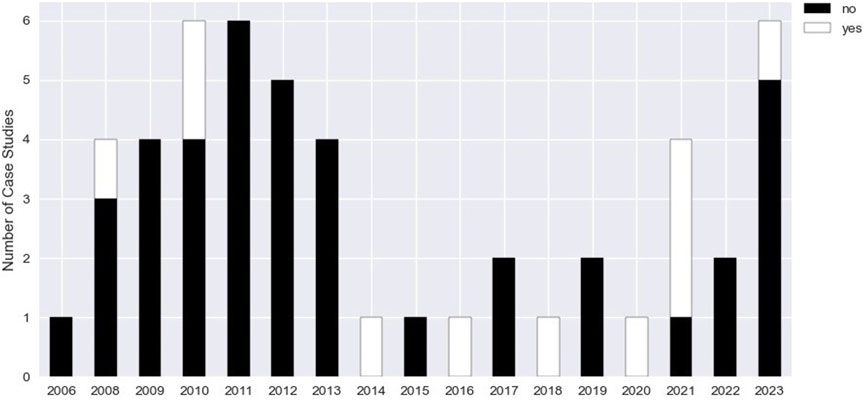
Figure 7. ML used in Empirical studies over time.
We summarize the non-machine learning (non-ML) approaches in Figure 8. Most empirical studies employed multiple approaches, and we counted each approach only once; consequently, the number of approaches exceeds that of studies using non-ML approaches. Due to the diversity of the empirical studies, the approaches were often described in various degrees of detail.
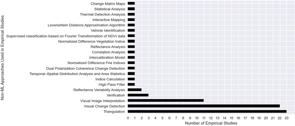
Figure 8. Prevalence of Non-ML approaches used in empirical studies.
Figure 8 shows the non-ML approaches applied, such as Triangulation, Visual Change Detection, and Visual Image Interpretation, which are among the most frequently used approaches.
Figure 9 shows that most empirical studies document damage characteristics, land use and land cover change, and/or fire patterns with RS data.
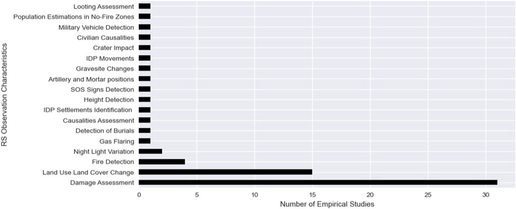
Figure 9. RS observation characteristics from empirical studies documenting conflict.
As pointed out above, a categorization of the human rights-related terms within the categories was often too diverse. Exemplarily we point that out for Land Use Land Cover Change where genocide, mass violence, war crimes, International Humanitarian Law (IHL), attacks against civilians, ecocide, and general human rights were used. Similarly, human rights-related terms within the empirical studies focusing on Damage Assessment(s) were broad. The mentioned aspects ranged from attacks on civilians, civilians in conflict, intentional burning, property rights, destruction and burning of places, IHL, ethnic cleansing, land clearance, crimes against humanity, war crimes, indiscriminate violence, destruction of civilian infrastructure, forced evictions, forced relocation, cultural artefacts, communal conflict, attack on medical facilities as well as pointing to human rights overall.
3.5 Validation practices
Figure 10 depicts that the type of validation data used changed over time: Until 2013, remote data validating hints from direct sources was used predominantly, while from 2014 onwards, remote data validating RS analyses were used more often.
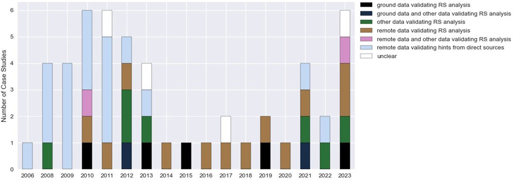
Figure 10. Validation data used in empirical studies over time.
3.6 Reported challenges
Figure 11 shows that most researchers declared data challenges, while some did not mention any challenges. Human and method challenges are less often declared, with remote and economic challenges being declared even more seldomly.

Figure 11. Declared challenges in empirical studies.
4 Discussion
Interpreting our results from a critical RS perspective, we take into account research from various fields, such as human rights, digital geography, law, as well as media studies. Doing so, the following discussion highlights that not all conflicts receive equal attention (I), RS studies reveal specific insights into conflict knowledge (II), and political and economic dependencies are not made transparent but can only be deduced (III). We see challenges due to the assumption that seeing is believing (IV) and uncertainties in validation mechanisms (V). We conclude that more collaborative research between RS researchers and human rights studies is needed (VI).
4.1 Not all conflicts receive equal attention
Figure 2 offers first insights into how our review and the selected empirical studies cover global conflict dynamics. The increase in empirical studies in recent years can be linked to the intensification of conflict violence, particularly conflict-related deaths, since 2019 (Uppsala University, 2025). To better understand the empirical studies’ coverage of specific conflict regions, a comparison with the Uppsala Conflict Data Program (UCDP) from the Department of Peace and Conflict Research (UCDP, 2014) is helpful. UCDP documents all known state-based violence, non-state-based violence, one-sided violence, and the total number of deaths. Such a comparison showcases that several conflicts, along with potentially related violations, were not investigated using satellite data or are not covered in our review. For example, while the UCDP records high death rates between 2006 and 2022 in the conflict areas of Burkina Faso and Mali, our corpus does not include empirical research into any one of these areas. The same is true for Niger, Chad, Yemen, Pakistan, Libya, Colombia, and Brazil.
The analysed empirical studies, therefore, betray that attention is skewed to select conflict areas while other conflict areas and related human rights violations remain neglected. Figure 4 reveals a marked research focus on conflicts in Ukraine, Syria, and Sudan. This focus can partly be explained by the conflict duration. The Russian invasion of Ukraine has been unfolding since 2022, and Russia invaded and annexed Crimea already in 2014 (Kulyk, 2023). Further, the start of the revolution in Syria goes back to 2011 (Al Jazeera, 2018), while Sudan experienced multiple conflict waves: two civil wars before 2011, as well as one conflict in the west of the country from 2003 to 2020, with another violent phase starting in 2023 (African Journal on Conflict Resolution, 2024; Hassan, 2023). Note, however, the difference between publishing date and conflict timeframes, as we use the year of the articles’ publication for our analyses and associated visualisations, not the period of conflict (Section 2). To clarify the relationship between the publishing date and conflict period, we checked all reviewed articles and found that in most empirical studies, the publishing date lies within the time of conflict. Another reason for the noted augmented coverage of Ukraine, Syria, and Sudan using RS data could be information biases in the media landscape of conflict reporting, as most conflict events are ignored (Jakobsen, 2000). This reporting bias likely influences satellite RS researchers’ perception of where research is needed. Arguably, the more a specific conflict is covered in the daily media, the higher the motivation to better understand these conflicts and related, potential human rights violations, translating into an incentive to conduct more analyses. If this is the case, it is especially unfortunate since RS data holds the potential to counteract the attention economy of media coverage with its worldwide geographical reach (Defries and Townsend, 1999).
4.2 RS studies reveal specific insights into conflict knowledge
Our corpus review revealed that the use of RS data in human rights studies remains underdeveloped, specifically as it often remains unclear what human rights violations were investigated and in what manner. Similar results on the use of RS and peace and security studies were reported by Avtar et al. (2021). The broadly defined selection criteria used to construct our corpus (Figure 1) may have led to the inclusion of papers that aimed to understand human rights violations only as by-products of armed conflict, not as phenomena apt to be the designated foci of research in their own right. Nevertheless, our review allows us to distil what kind of human rights-specific knowledge is and is not produced in relation to conflict areas, and where satellite data offer an opportunity to understand developments on the ground. For example, Figure 9 reveals that most empirical studies focused on Damage Assessment and Land Use and Land Cover Change analyses. Although the diversity of human rights aspects in these categories hindered our ability to classify them succinctly, Figure 9 nevertheless highlights the production of particular, conflict-related knowledge; everything that is detectable or measurable with digital sensors can be expressed in numbers, such as changes in infrastructures, building destruction, environmental changes and fire patterns. Our findings partially converge with Sticher et al. (2023), who points out two main foci in monitoring conflicts: first, damaged or destroyed buildings, and second, forced displacement, documented via population flows or refugee dwelling structures.
Furthermore, the extent to which legal implications were considered when RS observations were made hinged on the organisation conducting the research. Researchers operating outside of academia, for example, were more prone to take IHL or HRL into account. For instance, multiple empirical studies, collaboratively conducted by the AAAS and other NGOs, were merged into one extensive report that linked several violations (AAAS). Following this first report, the AAAS produced a follow-up report in 2018 (AAAS), explaining that one among several challenges for accountability institutions is to prove widespread, systematic patterns of violations over time. Remotely sensed data, the report continues, can be seen as the solution to this challenge, as RS can document patterns of attacks, changes of destruction, and military movements in inaccessible areas (AAAS). Our results show that academic researchers use more advanced RS analysis methods, as becomes clear when Figure 2 is considered in light of Figure 7. After 2014, when academic researchers started to publish RS research, the use of ML applications increased slightly. Using large datasets, statistical analytics, and ML approaches can help to identify patterns linked with war crimes or other atrocities. On the other hand, non-ML-driven approaches, such as Visual Change Detection, Visual Interpretation, or Triangulation (Figure 8), have mainly been applied by other organisations and NGOs (see Figure 2). Being more qualitative in nature, these non-ML-driven approaches often do not allow for comparable spatial coverage as they are time-intensive and dependent on external circumstances, such as reporting densities of social media channels. At the same time, the studies conducted in this qualitative manner, originating from organisations that are not exclusively academic (Figure 2), are more likely to consider legal implications.
Overall, our review reveals a range of research practices, with some considering legal implications and others not, resulting in varying and often vague human rights knowledge. Concretely, we find that academic researchers who rely on RS data and more quantitative-driven approaches tend not to consider legal implications, whereas other and NGOs, predominantly relying on more qualitative approaches when including satellite data in their work, consider IHL and, at times, HRL.
4.3 Political and economic dependencies are not transparent but can only be deduced
Critical perspectives on RS research point out that political and economic relations, revealed by national agreements (Zerbini and Fradley, 2018), data access denials (Sue, 2023) or economic costs (Bennett et al., 2022b). Those dependencies impact data analysis practices, specifically in the geopolitically sensitive context of armed conflict (Raymond 2014). Even so, most research in our review did not declare political and economic dependencies but instead elaborated on other types of data limitations. Figure 11 shows which studies disclose data availability and economics as challenges. Some researchers acknowledge (Figure 6) special deals they have with commercial satellite providers. Though such companies advertise the use of open data for NGOs and researchers at universities (Planet, 2024), they act as gatekeepers, causing data accessibility issues. For example, as a reaction to the Gaza-Israel conflict starting in 2023, Planet often did not offer access to its data (Tani, 2023). While the problems that come with the described dependencies are well-known, Figure 6 reveals a continued and firm reliance on satellite data from commercial data providers, at least until 2015.
In the reviewed empirical studies, there is a tendency towards the use of very high and high spatial resolution (Figure 5), which enhances the risk of being dependent on commercial providers (Figure 6). Such dependencies can also impact the independence of human rights work. Since most of the commercial satellites are tasked satellites, only data for specific areas of interest is collected; in other words, “tasking is ordering” (Skywatch, 2023). To task a satellite, the satellite provider is sent the coordinates of an area of interest, a time frame, and an interval. However, in the specific context of conflicts, the necessity to task facilitates illustrative over comprehensive documentation: since tasking typically takes place for verification purposes after specific (and often particularly egregious) conflict events become known, the resultant coverage constitutes a probe into conflict events rather than their systematic documentation. Bennett et al. (2022b) attempt to counteract economic and political dependencies during conflict times and improve conflict monitoring, proposing to leverage VHR imagery by archiving it for research and humanitarian purposes, creating standardised conflict-wide mosaics for monitoring, and establishing a sustainably funded public satellite program. The role of commercial satellite companies is further subject of debate, particularly with regard to how these companies assist the military and, therefore, actors potentially violating IHL (Decker, 2023). This concern about commercial satellite providers in times of conflict arises since these companies provide services to both combatants as well as civilians and NGOs (Dunlap, 2023). van Benthem (2023) points out that technology companies increased their support for Ukraine after Russia’s full-scale invasion starting in February 2022, during which these actors assisted the military effort of a party to the conflict. Such assistance, however, raises questions with regard to the status and protection of private sector employees and company infrastructure under the law of armed conflict. Dunlap (2021) reflects on the assistance of satellite companies in Ukraine that provide photo intelligence to armed actors, contemplating in what ways these practices are consistent with international law. Commercial satellite providers fulfil multiple functions in the war: On the one hand, they support armed actors who commit violations, on the other hand, they provide actors with data that documents the violations committed by the armed actors. This example underlines the need for more socio-technical data perspectives, also for satellite data to be admissible as evidence in legal processes concerning alleged human rights violations in conflict zones. Additional uncertainties about the provenance of data from commercial and state sources, and a lack of transparency regarding data acquisition, pre- and post-processing pipelines, create potential differences in the reliability, trustworthiness, and admissibility of data between commercial providers and state agencies. Clarke and Kendall (2019) point out that for digital data to fall within the evidentiary jurisdiction, there is also a need to assess the socio-political context of these digital platforms to understand better how digital data, such as satellite data, can gain evidentiary power. These contexts are yet to be fully explored and are the subject of a current investigation by the authors.
Overall, we find that political and economic dependencies are rarely discussed or analysed in the empirical studies. However, by extracting what challenges in data availability were described in the studies, we were able to trace some of these dependencies. We, therefore, assert that although not declared, dependencies still play an essential role. Conflicts are not unfolding in isolation from the rest of the world but are occurring in a political and economic context. As elaborated on above, the same is true for the production of RS data. We see a need to make the dependencies of RS data on political and economic circumstances more visible and transparent to increase the admissibility of RS research for accountability purposes.
4.4 Seeing is believing
Visual interpretation and visual change detection, both based on visual interpretation, were the leading methods used in the empirical studies (Figure 8). Weizman and Weizman (2014, p. 6) explain that, when the event that constituted the action is not captured, visual change detection can establish “a direct line of causality between a singular action and a unique effect.” Therefore, they urge researchers to “fill the gap between the two images with a narrative” (Weizman and Weizman, 2014, p. 6). Several scholars point out that interpreting the visual characteristics of satellite data also comes with risks (Clarke and Kendall, 2019; Herscher, 2014; Lyons, 2012). Among these, the subjective character of visual analysis is the most significant (van Wyk, 2019). Social, political and personal factors can shape the subjectivity (Clarke and Kendall, 2019), and caution is specifically needed when the complex environments depicted in the images are unfamiliar to the researcher (Lyons, 2012). One of the most prominent examples of subjective visual interpretation of satellite imagery in a geopolitical context is the case of Powell’s presentation at the Security Council to press a case against Iraq in 2003. Offering aerial surveillance imagery as evidence, Powell accused Iraq of threatening global order by possessing weapons of mass destruction in violation of UN resolutions. Months later, after the US invasion of Iraq, these accusations were declared false (UN News, 2024). Herscher (2014) explains that what was read into these satellite images was what the US administration was most afraid of. Clarke and Kendall (2019) contend that the aerial evidence used in this example appears to speak for itself, also called the “evidence effect” of visual data or, in other words, “seeing is believing” (Van Wyk, 2019, p. 31). An additional problem with the subjectivity of visual interpretation is the limitation that satellite imagery cannot capture all incidents; for example, crimes such as gender-based violations remain “invisible” (Koenig and Egan, 2021). Even though visual methods abounded in the empirical studies (Figure 7), only a handful of researchers declared human challenges (Figure 10). The failure to reflect on the subjectivity of visual interpretation appears particularly problematic because in the given context of difficult-to-access war zones, RS data, is conceived of as a safe and objective alternative to traditional witness testimony (Marx and Loboda, 2013; Quinn et al., 2018), yet may be subjective, unreliable, flawed, or manipulated (Sticher et al., 2023).
Technological development and enhanced spatial resolution of satellite imagery over time may explain why visual detection has become so prominent; the improvement in spatial resolution allows non-experts to ease the use of RS data as the visual characteristics are fine-grained, containing increasing amounts of detail, and thereby enabling visual interpretation. Figure 2 shows that until 2013, most of the empirical studies were conducted by researchers from the Other and NGO category using very high spatial resolution data (Figure 5), while starting from 2013 onwards, more medium and low-spatial resolution data were applied. This was precisely the time when academic RS researchers, hence experts, entered the field (Figure 2). A AAAS report from 2016 (AAAS) demonstrates that human rights advocates use geospatial technologies in their work. According to AAAS and the United Nations Operational Satellite Applications Program (UNOSAT), progress in this area was made by applying their expertise to select human rights documentation projects in partnership with satellite imagery providers, advocacy organisations, and funders (AAAS). The researchers’ decision to use satellite imagery can be explained by data collection on the ground being arguably expensive, time-consuming, and potentially dangerous (Lavers et al., 2009). Yet, geospatial data are no panacea: If used by researchers with limited expertise, such as human rights advocates, errors are likely to be introduced (DeNicola, 2008). DeNicola (2008) offers a nuanced perspective on the recent inclusion of less experienced users, which he argues can diminish public confidence in RS imagery as a source of knowledge. He further explains that on the one hand, new users with limited expertise in satellite RS may produce inaccurate analyses, on the other hand, these new users are often skilled at gaining public attention.
While human biases are present in machine processes, data collection, and the interpretation of ML results, these biases materialise at levels different from the levels at which biases in human visual image interpretation manifest. Of the studies comprised in our corpus, only two used an unsupervised approach, whereas the rest used supervised algorithms (Figure 7). Supervised machine approaches, in addition to the human interaction, necessitate further human interaction, namely in labelling the training dataset. The interaction of humans with machines has been extensively discussed in other research areas where ML approaches are increasingly being used (Pugliese et al., 2021). Figure 7 shows, however, that a comparable rise cannot be observed in human rights-related research. The algorithm types used are diverse (Figure 8), which can be explained by the diversity of researched human rights characteristics (Figure 9).
Overall, minimising the risk of human misinterpretation from afar hinges on new methodological developments, and ML approaches can offer one such opportunity. However, researchers using data-driven approaches of this kind should never underestimate the continued need for human interaction. Unsupervised and supervised approaches are not immune to economic and political dependencies and, hence, always need to be considered in context.
4.5 Uncertainties in validation mechanisms
The high publication rate of academic researchers starting in 2013 (Figure 2) can be interpreted as the academic RS community understanding the importance of digital human rights research. However, this involvement of academic researchers increased the risk of new methodological limitations caused by the uncertainties within this research group’s validation methodologies. We observe a change in the validation methods (Figure 10): Until 2013, when researchers from the category Other & NGO were most active (Figure 2), RS information was used to validate pre-existing human rights claims (for example, from NGO networks on the ground). Following a shift in the prevalence of organisations around 2013, alongside human rights researchers, academic researchers entered the field. From that point on, a change is evident: RS information was no longer confined to validation but was instead used as a source for getting first insights (Figure 10). The RS analyses in recent studies were mainly validated with the help of remote data, for example, by visually interpreting a change over time with very high-resolution satellite data. Other analyses use other sources, for instance, UNOSAT’s visual damage data, news reports, reports, or statistical data. In addition to the limitations of visual detection discussed above, the reliance on news reports and other sources from conflict areas is potentially problematic, too, as it comes with a high risk of forgery (Tokarczyk, 2023).
Some researchers stated that validation was impossible, whereas others refrained from disclosing any validation mechanisms (Figure 10). But validation is a critical component in an analysis cycle (Loew et al., 2017). Validation is “the consistency check of the RS data with reference measurements which are assumed to be representative of the truth, at least within their own reported uncertainties” (Loew et al., 2017, p. 780). As Leaning (2010, p. 202) points out, “in crisis areas, information is not prospectively or routinely gathered.” This illustrates the complexity of conflict documentation–and yet, we want to emphasise that data quality should not be compromised even if information is lacking. The above-described validation mechanism changes raise concerns about whether current practices of using visual image interpretation data or user-generated data reliably reveal the truth to the extent that remote results can be validated based on these practices. An alternative to the current practice of validation could be the information triangulation process described by Trager et al. (2022), who used an internal validation process with data from within their empirical RS study and triangulated this process externally with a literature review of known, publicly available surveys and interviews. This shows that alternative validation methodologies, when accessibility to the area of interest is limited, are possible. We emphasise the need for alternative robust validation methodologies beyond those used in our corpus.
4.6 More collaborative research between RS researchers and human rights studies is needed
The establishment of truth and knowledge varies in different epistemic communities (Figure 2), and so does their outcome. We acknowledge this diversity as a strength in our corpus, while also recognising the difficulty of disciplinary exchange when different documentation and transparency standards are in place. The review process (Figure 1) demonstrated that only a small number of articles met the criteria for linking the RS work with human rights work, but research beyond the selected corpus, shows potential to reveal human rights violations. For example, RS reflectance studies of buried animal corpses could further aid the detection of human mass graves (Molina et al., 2022). Also, patterns in the natural environment in times of conflict, detected with RS, can raise questions of responsibility. For example, when armies interfere in agricultural production or the environment itself is used as a weapon (Negash et al., 2023). Long-term conflict monitoring with RS can also present new insights about the duration of conflict events and their impacts, which is relevant for questions of human rights accountability. Conflict events can affect food production and result in long-term changes in land management (Demissie et al., 2022), and the impacts on ecosystem services often go beyond the duration of conflict events (Negash et al., 2023). Linking environmental observations with human rights can therefore offer new pathways (Zwijnenburg and Ballinger, 2023).
Such a collaboration can offer valuable opportunities but also raises new challenge; new technological data and tools, such as RS, create and shape new forms of knowledge (McPherson et al., 2019). This can result in unequal accessibility and raises questions about the ethical use of RS. Levinger (2009) reviewed two projects focused on genocide prevention, where non-experts could utilise satellite data to document the destruction of villages in an attempt to prevent future attacks in the Darfur region of Sudan. He advises that such data practices are not meant for the general public but rather for policy practitioners due to open ethical questions. Ethical questions are of particular relevance when satellite RS data are applied to understand incidents without physical access to the area of interest (Harris, 2013). Conflicts are embedded in contexts, and these contexts need to be well understood before analysis (Miall, 2007). It is important to empower those affected (Bennett et al., 2024), collaborative work between RS researchers and local stakeholders can enable context sensitive research. Overall, we see a need for more collaborative research beyond the traditional epistemic communities, to unite insights from the fields of human rights and RS.
5 Conclusion
This review analysed satellite RS studies covering countries affected by conflict with the aim of understanding the extent to which RS data are used for documenting human rights violations. Our results point to differences in geographical coverage and highlight how technology shapes the knowledge produced within and about conflicts. Further, this review uncovered how some researchers still rely on commercial satellite data while others, mainly academic researchers, also include public data in their empirical work. We elaborated on the opportunities of RS-driven methods in the context of documenting violations, particularly the coverage of large geographical areas and the diversity of spectral resolutions. While we emphasized the need for innovative validation mechanisms, we also pointed out that new technological developments must be reflected on to account for the ways in which data-driven approaches differ–both positively and negatively–from traditional human rights research methods. Overall, our review highlighted untapped potential with regard to the engagement of remote sensing experts in human rights-related research, where we see a particular need for more critical perspectives relying on RS. The development of new satellite RS technology and the expansion of the satellite market is expected to continue, a socio-technical evaluation of satellite RS analyses in conversation with human rights research is thus needed more than ever.
Author contributions
RE: Conceptualization, Data curation, Formal Analysis, Investigation, Methodology, Visualization, Writing – original draft, Writing – review and editing. GG: Conceptualization, Funding acquisition, Supervision, Writing – review and editing. KK: Conceptualization, Funding acquisition, Project administration, Supervision, Writing – review and editing. BW: Conceptualization, Funding acquisition, Supervision, Writing – review and editing.
Funding
The author(s) declare that financial support was received for the research and/or publication of this article. We thankfully declare receipt of a research grant provided by the Federal Ministry of Research, Technology and Space (BMFTR) and financially supported by the European Union-NextGenerationEU (Grant no. 16DKWN068).
Acknowledgments
We thank Brian Perlman and Alicja Polakiewicz for supporting the compilation of the corpus. We also appreciate Alicja Polakiewicz’s insightful feedback and editing, which greatly improved the clarity of language and argumentation.
Conflict of interest
The authors declare that the research was conducted in the absence of any commercial or financial relationships that could be construed as a potential conflict of interest.
Generative AI statement
The author(s) declare that no Generative AI was used in the creation of this manuscript.
Any alternative text (alt text) provided alongside figures in this article has been generated by Frontiers with the support of artificial intelligence and reasonable efforts have been made to ensure accuracy, including review by the authors wherever possible. If you identify any issues, please contact us.
Publisher’s note
All claims expressed in this article are solely those of the authors and do not necessarily represent those of their affiliated organizations, or those of the publisher, the editors and the reviewers. Any product that may be evaluated in this article, or claim that may be made by its manufacturer, is not guaranteed or endorsed by the publisher.
Supplementary material
The Supplementary Material for this article can be found online at: https://www.frontiersin.org/articles/10.3389/frsen.2025.1603575/full#supplementary-material
Abbreviations
AAAS, American Association for the Advancement of Science; API, Application Programming Interface; ESA, European Space Agency; HRL, Human Rights Law; IHL, International Humanitarian Law; ISO, International Organization for Standardization; KBA, Kyl-Bingaman Amendment; ML, machine learning; NGO, non-governmental organization; RS, remote sensing; UN, United Nations; UNOSAT, United Nations Operational Satellite Applications Program; USGS, United States Geological Survey; UCDP, Uppsala Conflict Data Program; V-Dem, Varieties of Democracy; VHR, very high spatial resolution; WMS, Web Map Service.
Footnotes
1Quinn et al. (2018) did not specify the area but used several regions of Africa and the Middle East; which we were not able to plot on the map
References
AAAS. Broadly accepted practices regarding the use of geospatial technologies for human rights, (n. d.). 3. Available online at: https://www.aaas.org/sites/default/files/s3fs-public/Broadly%2520Accepted%2520Practices_GTP_HRDT.pdf (Accessed October 6, 2024).
AAAS. Geospatial evidence in international human rights litigations, (n. d.). 52. Available online at: https://www.aaas.org/sites/default/files/s3fs-public/reports/Geospatial%2520Evidence%2520in%2520International%2520Human%2520Rights%2520Litigation.pdf (Accessed September 6, 2024).
AAAS. Human rights application of remote sensing, (n. d.). 49. Available online at: https://www.aaas.org/sites/default/files/2019-09/Human_Rights_Applications_of_Remote_Sensing_Revised.pdf (Accessed September 6, 2024).
African Journal on Conflict Resolution (2024). South Sudan conflict from 2013 to 2018: rethinking the causes, situation and solutions. Afr. J. Confl. Resolut. 18, 59–86.
Avtar, R., Kouser, A., Kumar, A., Singh, D., Misra, P., Gupta, A., et al. (2021). Remote sensing for international peace and security: its role and implications. Remote Sens. 13, 439. doi:10.3390/rs13030439
Bennett, M. M., Chen, J. K., Alvarez León, L. F., and Gleason, C. J. (2022a). The politics of pixels: a review and agenda for critical remote sensing. Prog. Hum. Geogr. 46, 729–752. doi:10.1177/03091325221074691
Bennett, M. M., van den Hoek, J., Zhao, B., and Prishchepov, A. V. (2022b). Improving satellite monitoring of armed conflicts. Earth’s Future 10, e2022EF002904. doi:10.1029/2022EF002904
Clarke, K. M., and Kendall, S. (2019). The beauty is that it speaks for itself: geospatial materials as evidentiary matters. Law Text. Cult. 23, 91–118. doi:10.14453/ltc.650
Decker, A. (2023). US says it won’t tell space-imagery companies to stop showing Gaza photos. Defense One.
Defries, R. S., and Townsend, J. R. G. (1999). Global land cover characterization from satellite data: from research to operational implementation global ecology and biogeography.
Demissie, B., Nyssen, J., Annys, S., Negash, E., Gebrehiwet, T., Abay, F., et al. (2022). Geospatial solutions for evaluating the impact of the Tigray conflict on farming. Acta Geophys. 70, 1285–1299. doi:10.1007/s11600-022-00779-7
DeNicola, L. (2008). Credibility and the use of geospatial media in activism and advocacy. Proc Assoc Info 45, 1–12. doi:10.1002/meet.2008.1450450251
Deroin, J.-P., Téreygeol, F., and Heckes, J. (2011). Evaluation of very high to medium resolution multispectral satellite imagery for geoarchaeology in arid regions - case study from Jabali, Yemen. J. Archaeol. Sci. 38, 101–114. doi:10.1016/j.jas.2010.08.015
Dubberley, S., Koenig, A., and Murray, D. (2020). in Digital witness: using open source information for human rights investigation, documentation, and accountability (Oxford: Oxford University Press).
Dunlap, J. C. (2021). Are commercial satellites used for intelligence-gathering in attack planning targetable? Available online at: https://sites.duke.edu/lawfire/2021/03/05/are-commercial-satellites-used-for-intelligence-gathering-in-attack-planning-targetable/ (Accessed June 10, 2024).
Dunlap, C. J. (2023). The law of war and ‘Dual Use’ commercial satellites: the nexus of commercial and national security space. Forthcoming.
EOS Data Analytics (2023). Satellite solutions for NGO and non-profit organizations. Available online at: https://eos.com/products/crop-monitoring/non-profits/ (Accessed August 22, 2024).
FEWS NET (2024). The inaccessibility of conflict-affected areas is leading to extreme food insecurity in northeast Nigeria. Available online at: https://fews.net/west-africa/key-message-update/october-2016 (Accessed August 22, 2024).
Harris, R. (2013). Reflections on the value of ethics in relation to Earth observation. Int. J. Remote Sens. 34, 1207–1219. doi:10.1080/01431161.2012.718466
Hassan, M. H. A. (2023). Sudan's disastrous war - and the science it is imperilling. Nature 623, 10. doi:10.1038/d41586-023-03341-7
Herscher, A. (2014). Surveillant witnessing: satellite imagery and the visual politics of human rights. PUBLIC Cult. 26, 469–500. doi:10.1215/08992363-2683639
ISO (2025). ISO - ISO 3166 — country codes. Available online at: https://www.iso.org/iso-3166-country-codes.html (Accessed January 27, 2025).
Jakobsen, P. V. (2000). Focus on the CNN effect misses the point: the real media impact on conflict management is invisible and indirect. J. Peace Res. 37, 131–143. doi:10.1177/0022343300037002001
Koenig, A. (2019). “Half the truth is often a great lie”: deep fakes, open source information, and international criminal law. AJIL Unbound 113, 250–255. doi:10.1017/aju.2019.47
Koenig, A., and Egan, U. (2021). Power and privilege. J. Int. Crim. Justice 19, 55–84. doi:10.1093/jicj/mqab014
Kulyk, V. (2023). National identity in time of war: ukraine after the Russian aggressions of 2014 and 2022. Problems Post-Communism 71, 296–308. doi:10.1080/10758216.2023.2224571
Lavers, C., Bishop, C., Hawkins, O., Grealey, E., Cox, C., Thomas, D., et al. (2009). Application of satellite imagery to monitoring human rights abuse of vulnerable communities, with minimal risk to relief staff. J. Phys. Conf. Ser. 178, 012039. doi:10.1088/1742-6596/178/1/012039
Leaning, J. (2010). “The use of patterns in crisis mapping to combat mass atrocity crimes,” in Mass atrocity crimes (Brookings Institution Press), 192–219.
Levinger, M. (2009). Geographical information systems technology as a tool for genocide prevention: the case of Darfur. Space Polity 13, 69–76. doi:10.1080/13562570902781249
Lillesand, T. M., KieferRalph, W., and Chipman, J. W. (2002). Remote sensing and image interpretation.
Loew, A., Bell, W., Brocca, L., Bulgin, C. E., Burdanowitz, J., Calbet, X., et al. (2017). Validation practices for satellite-based Earth observation data across communities. Rev. Geophys. 55, 779–817. doi:10.1002/2017RG000562
Lyons, J. (2012). Documenting violations of international humanitarian law from space: a critical review of geospatial analysis of satellite imagery during armed conflicts in Gaza (2009), Georgia (2008), and Sri Lanka (2009). Int. Rev. Red. Cross 94, 739–763. doi:10.1017/S1816383112000756
Marx, A. J. (2013). A new approach to detecting mass human rights violations using satellite imagery.
Marx, A., and Goward, S. (2013). Remote sensing in human rights and international humanitarian law monitoring: concepts and methods. Geogr. Rev. 103, 100–111. doi:10.1111/j.1931-0846.2013.00188.x
Marx, A. J., and Loboda, T. V. (2013). Landsat-based early warning system to detect the destruction of villages in Darfur, Sudan. Remote Sens. Environ. 136, 126–134. doi:10.1016/j.rse.2013.05.006
McPherson, E., Thornton, I. G., and Mahmoudi, M. (2019). Open source investigations and the technology-driven knowledge controversy in human rights fact-finding. 68–86. doi:10.1093/law/9780198836063.003.0005
Miall, H. (2007). “Conflict and context,” in Emergent conflict and peaceful change (Basingstoke: Palgrave Macmillan), 85–94.
Molina, C. M., Castellanos, D., Baena, A., Salgado, A., and Pringle, J. (2022). Forced disappearances and missing people in Colombia, South America. Forensic Sci. Int. Rep. 6, 100287. doi:10.1016/j.fsir.2022.100287
Murray, D., McDermott, Y., and Koenig, K. A. (2022). Mapping the use of open source research in UN human rights investigations. J. Hum. Rights Pract. 14, 554–581. doi:10.1093/jhuman/huab059
Negash, E., Birhane, E., Gebrekirstos, A., Gebremedhin, M. A., Annys, S., Rannestad, M. M., et al. (2023). Remote sensing reveals how armed conflict regressed woody vegetation cover and ecosystem restoration efforts in Tigray (Ethiopia). Sci. Remote Sens. 8, 100108. doi:10.1016/j.srs.2023.100108
Planet (2024). Nonprofit Program | Planet. Available online at: https://www.planet.com/nonprofit/ (Accessed June 9, 2024).
Poe, S. C., and Tate, C. N. (1994). Repression of human rights to personal integrity in the 1980s: a global analysis. Am. Polit. Sci. Rev. 88, 853–872. doi:10.2307/2082712
Pugliese, R., Regondi, S., and Marini, R. (2021). Machine learning-based approach: global trends, research directions, and regulatory standpoints. Data Sci. Manag. 4, 19–29. doi:10.1016/j.dsm.2021.12.002
Quinn, J. A., Nyhan, M. M., Navarro, C., Coluccia, D., Bromley, L., and Luengo-Oroz, M. (2018). Humanitarian applications of machine learning with remote-sensing data: review and case study in refugee settlement mapping. Philosophical Trans. Ser. A, Math. Phys. Eng. Sci. 376, 20170363. doi:10.1098/rsta.2017.0363
Raleigh, C., Kishi, R., and Linke, A. (2023). Political instability patterns are obscured by conflict dataset scope conditions, sources, and coding choices. Humanit Soc. Sci. Commun. 10, 74–17. doi:10.1057/s41599-023-01559-4
Sacco, V., and Bossio, D. (2015). Using social media in the news reportage of war & conflict: Opportunities and challenges. JOMI 2, 59–76. doi:10.5617/jmi.v2i1.898
Skywatch (2023). How tasking satellites can help you capture amazing photos from space with SkyWatch. SkyWatch.
Sticher, V., Wegner, J. D., and Pfeifle, B. (2023). Toward the remote monitoring of armed conflicts. PNAS Nexus 2, pgad181. doi:10.1093/pnasnexus/pgad181
Sue, K. (2023). Spies in the skies: analyzing the development of the U.S. commercial satellite industry vis-à-vis the hermit kingdom. Georgt. Secur. Stud. Rev. Available online at: https://repository.library.georgetown.edu/bitstream/handle/10822/1086552/KimSue-Spies-in-the-Skies.pdf?sequence=1 (Accessed June 10, 2024).
Trager, S., Leigh, J., Woods, A., Parmar, P., Petty, A., Haar, R., et al. (2022). Consistency of reports of violence from northern Rakhine state in August 2017. Confl. Health 16, 22. doi:10.1186/s13031-022-00453-1
UCDP (2014). UCDP - Uppsala conflict data program. Available online at: https://ucdp.uu.se/exploratory (Accessed June 9, 2024).
Ulrich, H., Kock-Schoppenhauer, A.-K., Deppenwiese, N., Gött, R., Kern, J., Lablans, M., et al. (2022). Understanding the nature of metadata: systematic review. J. Med. Internet Res. 24, e25440. doi:10.2196/25440
UN News (2024). Stories from the UN archive: the presentation that launched a war. Available online at: https://news.un.org/en/story/2024/02/1146332 (Accessed January 27, 2025).
United Nations, University of California (2022). “Berkeley protocol on digital open source investigations: a practical guide on the effective use of digital open source information in investigating violations of international criminal, human rights and humanitarian law,” in United Nations Human Rights Office of the high commissioner; Human Rights Center UC Berkeley school of law. New York, Geneva.
Uppsala University (2025). Uppsala Conflict data program. Available online at: https://ucdp.uu.se/exploratory (Accessed January 27, 2025).
van Benthem, T. J. (2023). Privatized frontlines: private-sector contributions in armed conflict. IEEE Conference Publication.
van Wyk, J.-A. (2019). Pixels, politics and peace: the forensic use of satellite imagery. J. Afr. Foreign Aff. 6, 31–50. doi:10.31920/2056-5658/2019/v6n2a2
Weizman, I., and Weizman, E. (2014). Weizman, Ines und Weizman, Eyal, Vorher und Nachher. Die Architektur der Katastrophe.
Zerbini, A., and Fradley, M. (2018). Higher resolution satellite imagery of Israel and Palestine: reassessing the Kyl-Bingaman amendment. Space Policy 44-45, 14–28. doi:10.1016/j.spacepol.2018.03.002
Keywords: critical remote sensing, conflict monitoring, human rights, literature review, accountability
Citation: Edler R, Glasze G, Kinzelbach K and Walker BB (2025) Remote sensing analysis for documenting human rights violations in zones of armed conflict: a systematic review of empirical research . Front. Remote Sens. 6:1603575. doi: 10.3389/frsen.2025.1603575
Received: 31 March 2025; Accepted: 24 September 2025;
Published: 24 October 2025.
Edited by:
Surajit Ghosh, International Water Management Institute, Sri LankaReviewed by:
José Muñoz-Rojas, University of Evora, PortugalQerim Qerimi, University of Pristina, Albania
Copyright © 2025 Edler, Glasze, Kinzelbach and Walker. This is an open-access article distributed under the terms of the Creative Commons Attribution License (CC BY). The use, distribution or reproduction in other forums is permitted, provided the original author(s) and the copyright owner(s) are credited and that the original publication in this journal is cited, in accordance with accepted academic practice. No use, distribution or reproduction is permitted which does not comply with these terms.
*Correspondence: Raphaela Edler, cmFwaGFlbGEuZWRsZXJAZmF1LmRl