 Mhd. Suhyb Salama
- Faculty of Geoinformation Science and Earth Observation (ITC), University of Twente, Enschede, Netherlands
Editorial on the Research Topic
Achieving SDG 6: Remote Sensing Applications in Sustainable Water Management
1 Introduction
Sustainable Development Goal 6 (SDG 6, Clean Water and Sanitation) is a foundational pillar of the 2030 Agenda, aiming to ensure universal access to safe and affordable drinking water, sanitation, and hygiene, while promoting the sustainable management of water resources. It encompasses critical targets including the elimination of open defecation, improvements in water quality, enhanced water-use efficiency, and protection of aquatic ecosystems. Achieving SDG 6 is vital not only for public health but also for reducing poverty, ensuring educational attainment, and enabling economic development.
Despite notable progress, significant disparities persist in water service coverage, with billions of people still lacking access to basic sanitation and safe drinking water. Many regions face compounding pressures from water scarcity, pollution, climate change, and inadequate infrastructure. In response, remote sensing technologies, particularly satellite-based sensors, are increasingly used to support large-scale, cost-effective monitoring of water quantity and quality, offering spatial and temporal coverage that complements traditional field-based methods.
This Research Topic in Frontiers in Remote Sensing highlights innovative applications of remote sensing and Earth Observation (EO) that support the realization of SDG 6. We present four articles that span a diverse spectrum of technologies, methodologies, and geographic contexts, collectively showcasing the growing maturity and impact of remote sensing in sustainable water management. While the broader discourse around SDG 6 has often emphasized the quantitative aspects of water (such as availability and access) these contributions notably centre on the quality dimension of SDG 6. This focus is both timely and essential, as water quality has historically received comparatively less attention despite its critical role in achieving sustainable water outcomes. The first contribution, by Saranathan et al. introduce probabilistic neural networks to retrieve water quality indicators with associated uncertainty estimates, enabling confidence-based decision-making in data-scarce environments. Whereas, Balasubramanian et al. leverage machine learning and multi-mission satellite archives to reconstruct long-term water quality trends, facilitating retrospective assessments, essential for monitoring policy effectiveness and environmental change. On the other hand, Atton Beckmann et al. demonstrate the power of high-resolution satellite imagery to monitor algal blooms in small, under-monitored inland lakes, significantly expanding the scope of water bodies that can be routinely assessed from space. Finally, Wilson et al. address systemic barriers to EO adoption, offering inclusive, action-oriented pathways to empower data-poor regions, particularly in the Global South.
Together, these contributions underscore the critical role that remote sensing technologies and EO play in advancing the objectives of SDG 6. These technologies have matured to the point where they are actively enhancing water quality monitoring, expanding spatial and temporal data coverage, informing evidence-based policy, and enabling the early detection of ecological threats. Yet, realizing the full potential of EO requires urgent attention to persistent challenges: the difficulty of integrating EO products into national regulatory and decision-making frameworks; the limited availability of robust, transferable algorithms for optically complex water bodies; the current inability of EO to detect emerging pollutants or non-optically active water quality constituents; and the lack of integration with predictive water quality models and complementary sensing technologies, particularly in the Global South. Addressing these challenges will require sustained investment in EO infrastructure, open-data platforms, algorithm innovation, capacity-building, and interdisciplinary collaboration.
In the sections that follow, we first define the scope of the articles included in this Research Topic and clarify the central focus of this editorial essay. We then outline the role of remote sensing and EO in advancing SDG 6, with particular attention to the specific targets where these technologies offer the greatest impact. Next, we summarize the key contributions of the featured papers, highlighting their methodological innovations and practical insights. This is followed by a discussion of emerging directions aimed at enhancing the utility, adoption, and influence of EO in driving progress toward SDG 6. We conclude with reflections on the broader implications of these findings and offer recommendations for future research, policy, and implementation.
2 Scope
The articles in this Research Topic primarily focus on the remote sensing of water quality, reflecting a key dimension of ensuring clean water for all. While water quality is a central concern, it is important to recognize SDG 6 encompasses a broader and more integrated vision. The goal aims to ensure availability and sustainable management of water and sanitation for all by 2030, covering a wide range of targets related to water governance and resource management.
Beyond improving water quality, SDG 6 addresses critical objectives such as equitable access to safe and affordable drinking water, universal access to sanitation and hygiene, and increased water-use efficiency across sectors. It also calls for the sustainable management of freshwater resources and ecosystems, the safe treatment and reuse of wastewater, and the creation of enabling environments through policies and institutional frameworks. Moreover, SDG 6 emphasizes the importance of international cooperation and capacity-building, particularly for developing countries, to strengthen water and sanitation-related programs and activities.
These broader Research Topic will be briefly addressed in the following section, “Setting the Scene” to provide context on how remote sensing aligns with the full scope of SDG 6. However, the main body of this editorial will primarily focus on water quality, reflecting the central theme of the contributions in this Research Topic. The final section on Future Directions will explore opportunities to expand and deepen the role of EO technologies in advancing the remote sensing of water quality as a key component of SDG 6 implementation.
Throughout this paper, the terms “remote sensing technologies” and “Earth Observation (EO)” are used interchangeably to reflect the integrated nature of EO systems, which encompass satellite, aerial, UAV-based, and in-situ sensing platforms.
3 Setting the scene for remote sensing of SDG 6
As regulatory agencies, national governments, and international organizations work to implement SDG 6, remote sensing and EO are playing an increasingly important role in supporting both policy development and regulatory compliance. In this context, EO helps close critical data gaps that hinder effective water governance. Its capabilities directly support the assessment of progress toward environmental standards and several SDG 6 targets, including:
1. Target 6.1 – Safe and Affordable Drinking Water: EO supports the identification and assessment of surface water bodies that can serve as potential sources of safe and affordable drinking water. By detecting seasonal fluctuations, water extent, and potential sources of contamination, EO helps decision-makers prioritize investments in water supply infrastructure and track service delivery in underserved or remote regions.
2. Target 6.3 – Water Quality and Pollution Reduction: EO is instrumental in monitoring ambient water quality variables such as turbidity and chlorophyll-a. It can also help identify pollution hotspots and track untreated or partially treated wastewater discharges into freshwater bodies. When combined with land use and infrastructure data, EO enables assessments of the interactions between pollution sources and water systems, supporting regulatory action and the design of cleaner water management systems.
3. Target 6.4 – Water-Use Efficiency and Scarcity: Remote sensing provides early warning of water scarcity by tracking variables such as surface water extent, soil moisture, evapotranspiration, and reservoir levels. In peri-urban and agricultural zones, remote sensing can help monitor evaporation rates, irrigation impacts, and thermal signatures of water withdrawals. These insights support drought preparedness, agricultural water management, and long-term water allocation planning, especially in arid and semi-arid regions experiencing increasing pressure from climate change.
4. Target 6.5 – Integrated Water Resources Management (IWRM): Due to its wide spatial coverage and high temporal resolution, EO significantly enhances the implementation of IWRM at local, national, and transboundary scales. Satellite-derived data can support basin-scale planning, identify upstream–downstream interactions, and monitor changes in land use, flow regimes, and ecosystem health over time. This is particularly important for transboundary river basins, where shared and objective data from EO can help build trust, foster cooperation among riparian countries, and support equitable water-sharing agreements. In addition, EO contributes to the standardization and comparability of water quality monitoring across regions, supporting compliance with international regulatory frameworks, such as the European Union Water Framework Directive. Remote sensing can help assess the ecological and chemical status of water bodies, track progress toward achieving “good status,” and provide complementary data to in-situ networks, thereby enhancing the operational capacity of environmental agencies and improving cross-border water governance.
5. Target 6.6 – Protection of Water-Related Ecosystems: EO technologies provide near-real-time information on the health and extent of water-related ecosystems, including wetlands, rivers, lakes, aquifers, forests, and mountain catchments. Changes in vegetation cover, wetland dynamics, primary production, sedimentation, or algal blooms can be detected through EO-data analysis, enabling rapid intervention to protect and restore critical ecosystems under threat from anthropogenic pressures or natural hazards.
4 Summary of this collection
Remote sensing technologies, from satellites to Unmanned Aerial Vehicles (UAVs), have emerged as powerful tools for tracking water quality indicators across large spatial and temporal scales. Optical sensors aboard Earth-observing satellites can detect near-surface concentrations of chlorophyll-a, coloured dissolved organic matter, total suspended solids, and other optically active substances, enabling regional to global assessments. This capability is increasingly critical as climate change and human activities intensify pressures on inland lakes and urban water systems. The integration of multi-mission satellite data streams has significantly improved the temporal resolution of observations, supporting more timely and actionable water management decisions.
Over the past decade, remote sensing applications for water quality management have advanced considerably. Satellite-based EO, when combined with in-situ measurements, proximal sensing, and machine learning techniques, now enables monitoring from global scales down to small, individual water bodies.
Key contributions to this Research Topic include:
- Saranathan et al. demonstrate that Mixture Density Networks and Bayesian Neural Networks with Monte Carlo Dropout can generate pixel-level probability distributions for key indicators such as chlorophyll-a. By quantifying uncertainty alongside the estimates, these models enable more informed decision-making and risk assessment. The broader Research Topic of uncertainty quantification for EO-derived water quality variables has been the subject of extensive research (Hammond et al., 2020; Mélin, 2021; 2019; 2010; Zhang et al., 2022). However, the use of neural networks models to estimate heteroscedastic and epistemic uncertainties at a pixel-level is relatively new. This development represents an important advancement in generating EO products that provide not only quantitative estimates of water quality indicators but also associated measures of uncertainty, enhancing their reliability for operational monitoring and decision-making.
While machine learning models are rapidly advancing, their opaque internal structures remain a challenge for transparency and interpretability. The proposed uncertainty-aware approach by Saranathan et al. represents a step forward toward developing more explainable and biophysically-informed AI algorithms for retrieving water quality variables (Jiang et al., 2020; Roy et al., 2023).
- Balasubramanian et al. reconstruct long-term time series of water quality indicators using historical EO datasets. The study harmonizes data from multiple satellite missions, including the Moderate Resolution Imaging Spectroradiometer (MODIS), Medium Resolution Imaging Spectrometer (MERIS), and Visible Infrared Imaging Radiometer Suite (VIIRS). It also applies machine learning models to the 40+ year Landsat archive. This integration enables the generation of multi-decadal records of inland and coastal water quality indicators, such as water clarity, algal blooms, and nutrient status. Crucially, the researchers went beyond algorithm development to operationalize EO-derived indicators across archived datasets, demonstrating their readiness for large-scale monitoring and policy support (Chen et al., 2022; Wilkinson et al., 2024).
Although such reconstruction approaches are essential for assessing the long-term effectiveness of environmental policies (such as nutrient reduction strategies) they still require further development to effectively integrate with current and forthcoming observations from a wide range of EO missions.
- Atton Beckmann et al. demonstrate the feasibility of quantifying phytoplankton in small lakes using high-resolution imagery from Planet SuperDoves and Sentinel-2. This capability is particularly valuable for mapping water quality in poorly monitored environments, such as small ponds and streams. Early demonstrations (e.g., Kwon et al., 2023; Mishra et al., 2020) established the feasibility of deriving water quality variables from meter-level satellite imagery. Building on this foundation, the study by Atton Beckmann et al. demonstrate that such imagery can accurately detect localized phenomena, such as algal scums and sediment plumes, with accuracy comparable to in-situ observations. As these high-resolution data sources become more routinely available, we can anticipate a significant expansion in the number of water bodies monitored globally, along with more granular integration of water quality data into urban management systems, e.g., smart city dashboards for water (Chen et al., 2023; Okoli and Kabaso, 2024).
While high-resolution data hold great potential for mapping previously unmonitored water bodies, their application is often challenged by the need to correct for variable scene illumination, surface reflectance, sun glint and geolocation. These Research Topic are especially pronounced when using Unmanned Aerial Vehicles (De Keukelaere et al., 2023; Windle and Silsbe, 2021).
- Wilson et al. argue that technological progress in EO must be matched by institutional support and user capacity in order to translate innovation into meaningful outcomes. Their study identifies major barriers to achieving SDG 6 in low- and middle-income countries, particularly related to infrastructure gaps, limited technical skills, and fragmented institutional mandates. While platforms like Google Earth Engine and other open-data tools have improved access to EO data, the technical capacity to process and apply these datasets remains limited in many contexts. To address these challenges, the authors propose a multifaceted strategy that includes raising public awareness through targeted campaigns, creating centralized hubs to improve access to EO data, expanding education and training programs to build scalable expertise, and fostering global coordination and policy alignment. They also highlight the role of global initiatives such as GEO AquaWatch and the World Water Quality Alliance in supporting the integration of EO into national monitoring systems and SDG reporting, particularly for indicator 6.3.2 (ambient water quality).
Despite progress in technical skill development, the transition toward sustained institutional capacity remains underdeveloped, limiting long-term and system-wide adoption (Pritchard et al., 2022; Thapa et al., 2019). As we enter the Fifth Industrial Revolution, characterized by the explosion of information and the integration of generative AI, new questions emerge around how to build adaptive and enduring capacity (Marino and Monaca, 2025; Ziatdinov et al., 2024; Gunderson et al., 2020; Orion, 2019). How can pedagogical approaches be designed to retain institutional knowledge while keeping pace with rapidly evolving technologies? Emerging learning tools such as virtual reality (Makransky and Petersen, 2021), digital twins (Hazeleger et al., 2024), serious games (Sajjadi et al., 2022), gamification and generative AI tools (Patra et al., 2024) offer promising avenues. Yet, these questions remain open and are the subject of ongoing inquiry as the landscape of AI-driven capacity-building continues to evolve.
Across these contributions, a consistent set of technologies and data infrastructures emphasize the advancement of remote sensing for SDG 6. The Sentinel constellation (Sentinel-2 and Sentinel-3) and the Landsat series remain the backbone of optical water quality monitoring, widely applied in both regional case studies and global assessments. Complementing these are legacy ocean-colour missions such as Moderate Resolution Imaging Spectroradiometer (MODIS), Medium Resolution Imaging Spectrometer (MERIS), Visible Infrared Imaging Radiometer Suite (VIIRS), and Ocean and Land Colour Instrument (OLCI), which support long-term trend analysis across large water bodies. More recently, hyperspectral satellite missions—including Plankton, Aerosol, Cloud, ocean Ecosystem, PACE (Werdell et al., 2019), PRecursore IperSpettrale della Missione Applicativa, PRISMA (Candela et al., 2016) and Environmental Mapping and Analysis Program, EnMAP (Storch et al., 2023) —have begun to demonstrate their enhanced ability to resolve optically complex waters, such as those rich in suspended matter or algal pigments, though their integration into operational workflows is still in its early stages. On the ground, the development of extensive in situ datasets—such as the GLObal Reflectance community dataset for Imaging and optical sensing of Aquatic environments, GLORIA (Lehmann et al., 2023), Lake Bio-optical Measurements and Matchup Data for Remote Sensing, LIMNADES (Carrea et al., 2015), SeaWiFS Bio-optical Archive and Storage System, SeaBASS (Werdell et al., 2003) and various regional monitoring networks, has proven essential for training and validating analytical and machine learning algorithms. These datasets enable robust generalization across diverse water types and geographies. In parallel, cloud-based platforms and pre-processed EO datasets, such as atmospherically corrected surface reflectance, are lowering technical barriers by streamlining data access, processing, and integration. These advances are enabling more consistent, scalable, and regionally transferable approaches to EO-based water quality monitoring.
5 Future directions in remote sensing of water quality
As remote sensing technologies and EO continue to mature and diversify, the scope of remote sensing applications for sustainable water management is rapidly expanding. Looking ahead, six strategic priorities emerge that can further strengthen the role of remote sensing in improving water quality targets of SDG 6.
5.1 Monitoring small water bodies for drinking water security
With the rapid depletion of groundwater resources and increasing hydrological variability driven by climate change, small surface water bodies are becoming vital sources of drinking water, particularly for rural, peri-urban, and marginalized communities (Jasechko et al., 2024). These lakes, ponds, and reservoirs, often less than 1 km2 in area, remain among the least monitored yet most vulnerable to contamination and seasonal fluctuations. Historically overlooked by traditional water management systems due to their small spatial footprint and remoteness, their importance in local water supply is steadily growing.
The use of sub-meter high-resolution EO platforms (such as Pléiades, WorldView, and UAVs) has the potential to substantially improve monitoring of small water surfaces by providing data at scales relevant for local water management and policy implementation. Figure 1 presents a pan-sharpened Pléiades image of the Sekdoornse Plas in the Netherlands, where floating solar panels have been installed. This pond, currently being explored for its potential to complement the local drinking water supply while also serving as a site for green energy production, exemplifies the integration of renewable infrastructure with small water bodies. This approach reflects the growing importance of multi-functional water resource management, particularly in regions facing increasing demand and water stress. High-resolution EO data, such as the image presented in Figure 1, enable detailed assessments of how floating solar installations influence water quality like photosynthetically available radiation and light attenuation coefficients, which in turn affect lake stratification and lake–atmosphere heat exchange (Heiskanen et al., 2015). Meanwhile, high-resolution thermal EO capabilities are being actively developed under missions such as the ESA Land Surface Temperature Monitoring (LSTM, Koetz et al., 2019) and NASA’s Surface Biology and Geology (SBG, Stavros et al., 2023). These missions aim to provide thermal data at spatial resolutions fine enough (30–100 m) to detect water surface temperature anomalies. In parallel, commercial satellite constellations are emerging with even finer Thermal InfraRed capabilities. For instance, HotSat1 by SatVu captures detailed heat variations across the Earth’s surface with a resolution of up to 3.5 m, both day and night. These systems offer potential for fine-scale assessment of surface temperature gradients, particularly in the context of floating infrastructure and climate-sensitive inland waters. For example, Prandini et al. (2025) showed, using detailed in-situ measurements, that floating solar modules created a microclimate above them with temperatures approximately 12% higher than those recorded by weather stations in the surrounding area. When coupled with biophysical lake models, EO data can support the quantification of energy fluxes (e.g., latent heat) and help infer biogeochemical processes like CO2 exchange linked to algal primary production (MacIntyre et al., 2010).
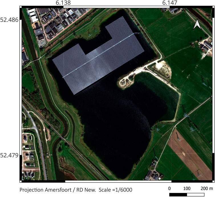
Figure 1. Pan-sharpened Pléiades Neo image of the Sekdoornse Plas (Netherlands) at 0.3 m spatial resolution. The image was acquired on 2025-04-07 and provided via the Netherlands Space Office Satellite Data Portal.
To fully unlock the potential of high-resolution, future research should prioritize the development of robust EO algorithms and integrating them with biophysical and ecological models specifically designed for small, optically complex water bodies. Incorporating these water bodies into national SDG indicator frameworks could help guide targeted investments and strengthen resilience in water-scarce regions, ensuring that these often-overlooked resources are effectively monitored, managed, and protected.
5.2 Imaging spectroscopy of emerging contaminants
One of the most pressing yet understudied frontiers in remote sensing is the detection of emerging contaminants in aquatic systems. These include microbial pathogens (e.g., Escherichia coli, Vibrio spp.), heavy metals, dissolved nutrients, pharmaceutical residues, endocrine-disrupting compounds (EDCs), personal care products (PPCPs), per- and polyfluoroalkyl substances (PFAS), and microplastics. Detecting these pollutants using satellite or airborne platforms remains challenging due to their typically low concentrations and the absence of distinct absorption or reflectance features detectable by EO sensors. Consequently, they are largely invisible to traditional multispectral sensors. These contaminants are often linked to land-based pollution sources such as household wastewater, agricultural runoff, and urban stormwater, posing significant ecological and human health risks, especially in regions with inadequate sanitation infrastructure. However, recent advancements in remote sensing technologies, particularly hyperspectral imaging, offer new opportunities. With its capacity to capture continuous, high-resolution spectral signatures across narrow wavelength intervals, hyperspectral remote sensing holds promise for detecting subtle spectral patterns that could be associated with these pollutants.
For microplastics, hyperspectral imaging has already demonstrated success in both laboratory and environmental settings, enabling pixel-level identification of polymer types based on their distinct spectral features (Balsi et al., 2025; de Fockert et al., 2024; Gebejes et al., 2024; Faltynkova et al., 2021). Detection may occur directly (when high concentrations or surface accumulations are present) or indirectly through proxies such as fluorescence, water colour, or algal community shifts. Similarly, while direct detection of PFAS remains nascent (Tshangana et al., 2025), optical sensing technologies such as Raman spectroscopy and microcavity sensors have been shown to discriminate PFAS compounds based on their vibrational spectral characteristics (Chen et al., 2024; Rodriguez et al., 2020), suggesting a foundation for future hyperspectral adaptation.
Beyond plastic and chemical pollutants, microbial contamination can also be inferred through remote sensing. For instance, recent studies have used Sentinel-2 data in combination with environmental modelling to predict Salmonella and Vibrio presence in river systems based on variables such as turbidity, temperature, and chlorophyll-a (Palharini et al., 2025). While these approaches do not detect microbes directly, they represent viable early-warning systems based on proxies.
Heavy metals and dissolved nutrients have shown more direct optical detectability in some cases. Red and Near Infrared reflectance and hyperspectral indices, when integrated with machine learning models, have been used to estimate concentrations of metals such as copper, lead, and cadmium in inland waters (Xu et al., 2024). Similarly, advances in fluorescence spectroscopy and high-resolution EO data are enabling assessments of nutrient concentrations, dissolved organic carbon, and related water quality indicators (Ngamile et al., 2025; Kumar et al., 2024). Despite this progress, detection of pharmaceutical residues, PPCPs, and EDCs remains in the early stages of remote sensing applicability. Current research relies largely on in-situ optical and biosensing platforms to characterize the presence and dynamics of these compounds (Li et al., 2024).
To move toward operational monitoring, future efforts should prioritize the integration of airborne and satellite hyperspectral missions (e.g., EnMAP, PRISMA, PACE) with in-situ spectral libraries, chemometric modelling, and machine learning approaches. Such efforts could significantly extend EO’s capacity to monitor water quality beyond conventional optical parameters, bridging into the chemical and biological domains of contamination.
5.3 Triple sensing: EO, proximal sensing, and citizen science
Achieving SDG 6 requires monitoring systems that are not only accurate and scalable but also inclusive and grounded in local realities. A promising pathway lies in the integration of triple sensing approaches: combining satellite-based EO, proximal sensing, and citizen science. This fusion offers multi-scale framework to assess and manage water quality in ways that are technically robust and socially embedded.
The papers in this Research Topic have demonstrated how EO provides synoptic, repeatable, and large-scale coverage of surface water bodies, allowing for the routine monitoring of key water quality indicators. However, EO-derived water quality information is primarily restricted to the surface layer and can be significantly constrained by cloud cover (Uday et al., 2025), as well as by its inability to directly detect optically inactive contaminants (Vakili and Amanollahi, 2020).
Proximal sensing technologies, including UAV-mounted sensors, in-situ IoT devices, and mobile-based field platforms, help bridge critical observational gaps by providing high-frequency, high-resolution measurements at local scales (e.g., Kuusk et al., 2024). Proximal sensing is particularly effective in detecting fine-scale spatial heterogeneity and enabling rapid responses in small or dynamic water bodies. When deployed as part of a coordinated measurement network, they offer valuable coverage in both urban and rural contexts where EO data may be limited or unavailable (e.g., the WATERHYPERNET Ruddick et al., 2024).
Citizen science complements both modalities by engaging communities in data Research Topic and validation through mobile apps and low-cost kits. Mobile phone applications such as HydroColor (Leeuw and Boss, 2018) or EyeOnWater (Novoa et al., 2015) train volunteers in collecting water colour observations.
While citizen-sourced data offer promising opportunities for expanding water quality monitoring, they face critical challenges related to sensor calibration, data consistency, and scientific reliability (Pattinson et al., 2023). Variability in device types, user practices, and sampling protocols can introduce significant uncertainty. For instance, Mahama and Salama, (2024) reported notable inconsistencies in smartphone-based turbidity measurements, particularly in optically complex waters where such tools are often deployed. To address these limitations, calibration and validation against high-quality reference data—such as measurements from UAV-mounted sensors or IoT-enabled probes—are essential for correcting biases and improving usability (Bakar et al., 2025).
To realize this triple-sensing model at scale, it is essential to ensure data interoperability, standardization of quality-control protocols, consistent metadata reporting, and calibration across devices. Embedding citizen-generated observations within frameworks validated by proximal and EO data can enhance data reliability, while institutional support is crucial for integrating community-sourced data alongside conventional datasets. When implemented effectively, this integrative approach has to potential of delivering comprehensive, scalable, and trustworthy water-quality insights, supporting more resilient, inclusive, and evidence-based governance in line with SDG 6.
5.4 Digital twins for water quality
While digital twins have made substantial progress in hydrology, particularly for modelling river flows, flood dynamics, and drought forecasting (Yang et al., 2024), their application to water quality remains relatively underdeveloped (Hamzah et al., 2024). A digital twin for water quality entails a dynamic, real-time numerical representation of aquatic systems, continuously updated with observational data to simulate and predict spatial and temporal changes in key parameters such as nutrient concentrations, algal blooms, turbidity, and dissolved oxygen. To realize this vision, the integration of triple sensing frameworks with hydrodynamic, biophysical, and biogeochemical models (hereafter called process-based models) is essential. EO provides synoptic and temporally rich surface data; proximal sensors offer high-frequency, localized in situ observations; and citizen science fills critical data gaps through community-based monitoring. When assimilated into process-based models, these inputs enable three-dimensional, time-evolving simulations of water quality dynamics, capable of supporting scenario analysis, forecasting, and policy evaluation.
Although EO data assimilation with process-based models is a well-established approach for improving aquatic ecosystem simulations (e.g., Ciavatta et al., 2018), the assimilation of EO-derived water quality products remains relatively underutilized and is still not widespread in operational systems (Groom et al., 2019).
However, developing a unified global digital twin for water quality remains impractical due to the complexity, variability, and context-specific nature of aquatic systems. Each river basin, lake catchment, or coastal zone presents distinct hydrological, ecological, and socio-environmental conditions that require regionally tailored modelling approaches and calibration strategies. For example, Cho et al. (2020) argue in their review that a major challenge in assimilating EO data into water quality models lies in the uncertainty of EO observations and the spatiotemporal mismatches between measurement scales and the model grid and time domains. Addressing these limitations requires not only methodological advances (e.g., Salama et al., 2022) but also a shift toward more integrated modelling frameworks. As digital twin frameworks evolve, future efforts should prioritize the fusion of triple sensing data with process-based aquatic models at regional and global scales. Doing so will enable a new class of predictive tools that go beyond static or near-real-time monitoring, supporting early warning systems, pollution control strategies, and adaptive water quality governance. This convergence marks a critical step toward more intelligent, anticipatory, and evidence-driven water management systems aligned with the targets of SDG 6.
5.5 From research to operations
To ensure broader and sustained impact, remote sensing-based water quality products must move beyond research prototypes toward full operational integration. For EO-based services, reaching Technology Readiness Level 9 (TRL 9) signifies that a system is not only technically mature but has been demonstrated under real-world conditions and embedded within established monitoring workflows. This transition involves more than algorithm refinement: it requires integration into regulatory or institutional frameworks, development of automated and scalable processing pipelines, rigorous validation with in situ observations, and the establishment of user support mechanisms and training. Operational readiness also depends on sustained collaboration with stakeholders and a shift from individual capacity-building to institutional strengthening. This includes long-term organizational commitment, the establishment of technical and operational protocols, and alignment with existing standards for data quality, accessibility, interoperability, and reporting. While platforms such as Google Earth Engine, Digital Earth Africa, and Euro Data Cube have advanced the technical scalability of EO applications, broader and lasting adoption requires co-producing water quality information that is not only technically robust but also fit for use within regulatory frameworks and day-to-day decision-making.
5.6 Enhancing policy uptake and decision integration
Despite significant advances in EO, a persistent challenge lies in completing the value chain. Specifically, bridging the gap between data availability and its effective integration into decision-making processes (Virapongse et al., 2020). To increase uptake, remote sensing products must be integrated into institutional workflows, policy frameworks, and regulatory tools. This involves:
• Co-designing EO solutions with policymakers, water managers, and civil society to ensure relevance, usability, and alignment with real-world needs.
• Translating EO outputs into actionable indicators, thresholds, or risk scores that match local water guidelines and standards.
• Embedding EO-derived products into early warning systems, environmental impact assessments (EIAs), water safety plans, and SDG reporting dashboards.
• Demonstrating the socio-economic value of EO by quantifying how satellite-based monitoring reduces costs, increases responsiveness, or mitigates risks, particularly in resource-constrained contexts.
• Building institutional trust through capacity development, long-term partnerships, and transparent validation procedures that clarify limitations and uncertainties of EO products.
6 Conclusion
In summary, Earth Observation (EO) and remote sensing technologies are powerful enablers for operationalizing SDG 6. Their integration into water governance systems enhances data availability and transparency, while supporting more adaptive, evidence-based decision-making in the face of climate change and increasing demand for clean water. However, system-wide adoption requires expanding technical capabilities to include fine-scale water bodies and emerging pollutants, strengthening the integration of multi-modal sensors with process-based models, and advancing explainable AI techniques to improve the biophysical relevance of water quality retrievals. Equally important is the evolution of institutional capacity to keep pace with rapid technological change. While emerging tools like digital twins, virtual reality, and generative AI offer promise, durable knowledge systems remain essential.
Decisive next steps include aligning EO products with national SDG 6 reporting frameworks, expanding validation networks, particularly in the Global South, and securing long-term funding. These efforts must be supported by cross-sectoral alliances, open data practices, and strategic capacity building. Only then can EO move beyond its current technical role to become a foundational element of inclusive and resilient water quality management system.
Author contributions
MSS: Conceptualization, Formal Analysis, Investigation, Methodology, Visualization, Writing – original draft, Writing – review and editing.
Funding
The author(s) declare that financial support was received for the research and/or publication of this article. This work was in part supported by the Dutch Research Council (NWO) under the SPARKLES project (NWA.1507.21.001, Grant number 16422).
Acknowledgments
The author gratefully acknowledges the Netherlands Space Office for providing access to high-resolution commercial satellite data through the Satellite Data Portal for the whole Netherlands, thereby supporting its use within the scientific community.
Conflict of interest
The author declares that the research was conducted in the absence of any commercial or financial relationships that could be construed as a potential conflict of interest.
The author(s) declared that they were an editorial board member of Frontiers, at the time of submission. This had no impact on the peer review process and the final decision.
Generative AI statement
The author(s) declare that Generative AI was used in the creation of this manuscript. Generative AI tools, including Grammarly and Microsoft Copilot, were used solely for language editing and refinement. All ideas, interpretations, and original text were created by the author. AI assistance was limited to enhancing clarity, grammar, and style, without contributing to the conceptual or intellectual content of the work.
Publisher’s note
All claims expressed in this article are solely those of the authors and do not necessarily represent those of their affiliated organizations, or those of the publisher, the editors and the reviewers. Any product that may be evaluated in this article, or claim that may be made by its manufacturer, is not guaranteed or endorsed by the publisher.
References
Bakar, A. A. A., Bakar, Z. A., Yusoff, Z. M., Ibrahim, M. J. M., Mokhtar, N. A., and Zaiton, S. N. (2025). IoT-Based real-time water quality monitoring and sensor calibration for enhanced accuracy and reliability. Int. J. Interact. Mob. Technol. (iJIM) 19, 155–170. doi:10.3991/ijim.v19i01.51101
Balsi, M., Moroni, M., and Bouchelaghem, S. (2025). Plastic litter detection in the environment using hyperspectral aerial remote sensing and machine learning. Remote Sens. 17, 938. doi:10.3390/rs17050938
Candela, L., Formaro, R., Guarini, R., Loizzo, R., Longo, F., and Varacalli, G. (2016). “The PRISMA Mission.” In 2016 IEEE International Geoscience and Remote Sensing Symposium (IGARSS), 253–56. doi:10.1109/IGARSS.2016.7729057
Carrea, L., Embury, O., and Merchant, C. J. (2015). “Datasets related to in-land water for limnology and remote sensing applications: distance-to-land, distance-to-water, water-body identifier and lake-centre co-ordinates.” Geoscience Data Journal 2, 83–97. doi:10.1002/gdj3.32
Chen, J., Chen, S., Fu, R., Li, D., Jiang, H., Wang, C., et al. (2022). Remote sensing big data for water environment monitoring: current status, challenges, and future prospects. Earth’s Future 10, e2021EF002289. doi:10.1029/2021EF002289
Chen, S.-L., Chou, H.-S., Huang, C.-H., Chen, C.-Y., Li, L.-Y., Huang, C.-H., et al. (2023). An intelligent water monitoring IoT system for ecological environment and smart cities. Sensors 23, 8540. doi:10.3390/s23208540
Chen, Y., Yang, Y., Cui, J., Zhang, H., and Zhao, Y. (2024). “Decoding PFAS contamination via Raman spectroscopy: A combined DFT and machine learning investigation.” Journal of Hazardous Materials 465, 133260. doi:10.1016/j.jhazmat.2023.133260
Cho, K. H., Pachepsky, Y., Ligaray, M., Kwon, Y., and Kim, K. H. (2020). Data assimilation in surface water quality modeling: a review. Water Res. 186, 116307. doi:10.1016/j.watres.2020.116307
Ciavatta, S., Brewin, R. J. W., Skákala, J., Polimene, L., de Mora, L., Artioli, Y., et al. (2018). Assimilation of ocean-color plankton functional types to improve marine ecosystem simulations. J. Geophys. Res. Oceans 123, 834–854. doi:10.1002/2017JC013490
de Fockert, A., Eleveld, M. A., Bakker, W., Felício, J. M., Costa, T. S., Vala, M., et al. (2024). Assessing the detection of floating plastic litter with advanced remote sensing technologies in a hydrodynamic test facility. Sci. Rep. 14, 25902. doi:10.1038/s41598-024-74332-5
De Keukelaere, L., Moelans, R., Knaeps, E., Sterckx, S., Reusen, I., De Munck, D., et al. (2023). Airborne drones for water quality mapping in inland, transitional and coastal Waters—MapEO water data processing and validation. Remote Sens. 15, 1345. doi:10.3390/rs15051345
Faltynkova, A., Johnsen, G., and Wagner, M. (2021). Hyperspectral imaging as an emerging tool to analyze microplastics: a systematic review and recommendations for future development. Microplastics Nanoplastics 1, 13. doi:10.1186/s43591-021-00014-y
Gebejes, A., Hrovat, B., Semenov, D., Kanyathare, B., Itkonen, T., Keinänen, M., et al. (2024). Hyperspectral imaging for identification of irregular-shaped microplastics in water. Sci. Total Environ. 944, 173811. doi:10.1016/j.scitotenv.2024.173811
Groom, S., Sathyendranath, S., Ban, Y., Bernard, S., Brewin, R., Brotas, V., et al. (2019). Satellite ocean colour: current status and future perspective. Front. Mar. Sci. 6, 1–30. doi:10.3389/fmars.2019.00485
Gunderson, K., Holmes, R., and Loisel, J. (2020). Recent digital technology trends in geoscience teaching and practice. GSAT 30, 39–41. doi:10.1130/gsatg404gw.1
Hammond, M. L., Henson, S. A., Lamquin, N., Clerc, S., and Donlon, C. (2020). Assessing the effect of tandem phase Sentinel-3 OLCI sensor uncertainty on the estimation of potential ocean Chlorophyll-a trends. Remote Sens. 12, 2522. doi:10.3390/rs12162522
Hamzah, A., Aqlan, F., and Baidya, S. (2024). Drone-based digital twins for water quality monitoring: a systematic review. Digital Twins Appl. 1, 131–160. doi:10.1049/dgt2.12021
Hazeleger, W., Aerts, J. P. M., Bauer, P., Bierkens, M. F. P., Camps-Valls, G., Dekker, M. M., et al. (2024). Digital twins of the Earth with and for humans. Commun. Earth Environ. 5, 463. doi:10.1038/s43247-024-01626-x
Heiskanen, J. J., Mammarella, I., Ojala, A., Stepanenko, V., Erkkilä, K.-M., Miettinen, H., et al. (2015). Effects of water clarity on Lake stratification and lake-atmosphere heat exchange. J. Geophys. Res. Atmos. 120, 7412–7428. doi:10.1002/2014JD022938
Jasechko, S., Seybold, H., Perrone, D., Fan, Y., Shamsudduha, M., Taylor, R. G., et al. (2024). Rapid groundwater decline and some cases of recovery in aquifers globally. Nature 625, 715–721. doi:10.1038/s41586-023-06879-8
Jiang, S., Zheng, Y., and Solomatine, D. (2020). Improving AI system awareness of geoscience knowledge: symbiotic integration of physical approaches and deep learning. Geophys. Res. Lett. 47, e2020GL088229. doi:10.1029/2020GL088229
Koetz, B., Bastiaanssen, W., Berger, M., Defourney, P., del Bello, U., Drusch, M., et al. (2019). “Agriculture: land surface temperature monitoring (LSTM) mission,” in ESA living planet symposium. Milan, Italy.
Kumar, M., Khamis, K., Stevens, R., Hannah, D. M., and Bradley, C. (2024). In-situ optical water quality monitoring Sensors—Applications, challenges, and future opportunities. Front. Water 6. doi:10.3389/frwa.2024.1380133
Kuusk, J., Corizzi, A., Doxaran, D., Duong, K., Flight, K., Kivastik, J., et al. (2024). HYPSTAR: a hyperspectral pointable system for terrestrial and aquatic radiometry. Front. Remote Sens. 5. doi:10.3389/frsen.2024.1347507
Kwon, D. H., Hong, S. M., Abbas, A., Park, S., Nam, G., Yoo, J.-H., et al. (2023). Deep learning-based super-resolution for harmful algal bloom monitoring of inland water. GIScience & Remote Sens. 60, 2249753. doi:10.1080/15481603.2023.2249753
Leeuw, T., and Boss, E. (2018). The HydroColor app: above water measurements of remote sensing reflectance and turbidity using a smartphone camera. Sensors 18, 256. doi:10.3390/s18010256
Lehmann, M. K., Gurlin, D., Pahlevan, N., Alikas, K., Conroy, T., Anstee, J., et al. (2023). “GLORIA - A globally representative hyperspectral in situ dataset for optical sensing of water quality.” Scientific Data 10, 100. doi:10.1038/s41597-023-01973-y
Li, X., Shen, X., Jiang, W., Xi, Y., and Li, S. (2024). Comprehensive review of emerging contaminants: detection technologies, environmental impact, and management strategies. Ecotoxicol. Environ. Saf. 278, 116420. doi:10.1016/j.ecoenv.2024.116420
MacIntyre, S., Jonsson, A., Jansson, M., Aberg, J., Turney, D. E., and Miller, S. D. (2010). Buoyancy flux, turbulence, and the gas transfer coefficient in a stratified Lake. Geophys. Res. Lett. 37. doi:10.1029/2010GL044164
Mahama, P. N., and Salama, S. M. (2024). Calibration and validation of the HydroColor and citclops smartphone applications for water quality monitoring. Heliyon 10, e30100. doi:10.1016/j.heliyon.2024.e30100
Makransky, G., and Petersen, G. B. (2021). The cognitive affective model of immersive learning (CAMIL): a theoretical research-based model of learning in immersive virtual reality. Educ. Psychol. Rev. 33, 937–958. doi:10.1007/s10648-020-09586-2
D. Marino, and M. A. Monaca (2025). “Generative artificial intelligence and fifth industrial revolution,” Lecture notes in networks and systems (Switzerland, Cham: Springer Nature). doi:10.1007/978-3-031-73880-7
Mélin, F. (2010). Global distribution of the random uncertainty associated with satellite-derived chla. IEEE Geoscience And Remote Sens. Lett. 7, 220–224. doi:10.1109/LGRS.2009.2031825
Mélin, F. (2019). Uncertainties in ocean colour remote sensing. Int. Ocean-Colour Coord. Group (IOCCG).
Mélin, F. (2021). From validation statistics to uncertainty estimates: application to VIIRS ocean color radiometric products at European coastal locations. Front. Mar. Sci. 8. doi:10.3389/fmars.2021.790948
Mishra, V., Limaye, A. S., Muench, R. E., Cherrington, E. A., and Markert, K. N. (2020). Evaluating the performance of high-resolution satellite imagery in detecting ephemeral water bodies over West Africa. Int. J. Appl. Earth Observation Geoinformation 93, 102218. doi:10.1016/j.jag.2020.102218
Ngamile, S., Madonsela, S., and Kganyago, M. (2025). Trends in remote sensing of water quality parameters in inland water bodies: a systematic review. Front. Environ. Sci. 13. doi:10.3389/fenvs.2025.1549301
Novoa, S., Wernand, M., and van der Woerd, H. J. (2015). WACODI: a generic algorithm to derive the intrinsic color of natural waters from digital images. Limnol. Oceanogr. Methods 13, 697–711. doi:10.1002/lom3.10059
Okoli, N. J., and Kabaso, B. (2024). Building a smart water city: IoT smart water technologies, applications, and future directions. Water 16, 557. doi:10.3390/w16040557
Orion, N. (2019). The future challenge of Earth science education research. Discip. Interdiscip. Sci. Educ. Res. 1, 3. doi:10.1186/s43031-019-0003-z
Palharini, R. S. A., Reyes, M. S. G., Monteiro, F. F., Villavicencio, L. M. M., Adell, A. D., Toro, M., et al. (2025). Challenges and potential of remote sensing for assessing salmonella risk in water sources: evidence from Chile. Microorganisms 13, 1539. doi:10.3390/microorganisms13071539
Patra, S., Singha, T. S., Kanvinde, M., Mazumdar, A., and Kanjilal, S. (2024). Harnessing AI for geosciences education: a deep dive into chatGPT’s impact. Geosci. Commun. Discuss., 1–28. doi:10.5194/gc-2023-7
Pattinson, N. B., Taylor, J., Dickens, C. W. S., and Graham, P. M. (2023). Digital innovation in citizen science to enhance water quality monitoring in developing countries. International Water Management Institute. doi:10.5337/2024.201
Prandini, M. K., Bueno, R. d. C., Rigotti, J. A., Bleninger, T., Mannich, M., and Novak, L. H. (2025). “High frequency monitoring for impact assessment of temperature, oxygen and radiation in floating photovoltaic system.” Scientific Reports 15, 19719. doi:10.1038/s41598-025-96257-3
Pritchard, R., Alexandridis, T., Amponsah, M., Ben Khatra, N., Brockington, D., Chiconela, T., et al. (2022). Developing capacity for impactful use of Earth observation data: lessons from the AfriCultuReS project. Environ. Dev. 42, 100695. doi:10.1016/j.envdev.2021.100695
Rodriguez, K. L., Hwang, J. -H., Esfahani, A. R., Sadmani, A. H. M. A., and Lee, W. H. (2020). “Recent Developments of PFAS-Detecting Sensors and Future Direction: A Review.” Micromachines, 667. doi:10.3390/mi11070667
Roy, A., Kasiviswanathan, K. S., Patidar, S., Adeloye, A. J., Soundharajan, B.-S., and Ojha, C. S. P. (2023). A physics-aware machine learning-based framework for minimizing prediction uncertainty of hydrological models. Water Resour. Res. 59, e2023WR034630. doi:10.1029/2023WR034630
Ruddick, K. G., Brando, V. E., Corizzi, A., Dogliotti, A. I., Doxaran, D., Goyens, C., et al. (2024). WATERHYPERNET: a prototype network of automated in situ measurements of hyperspectral water reflectance for satellite validation and water quality monitoring. Front. Remote Sens. 5. doi:10.3389/frsen.2024.1347520
Sajjadi, P., Bagher, M. M., Myrick, J. G., Guerriero, J. G., White, T. S., Klippel, A., et al. (2022). Promoting systems thinking and pro-environmental policy support through serious games. Front. Environ. Sci. 10. doi:10.3389/fenvs.2022.957204
Salama, M. S., Spaias, L., Poser, K., Peters, S., and Laanen, M. (2022). Validation of Sentinel-2 (MSI) and Sentinel-3 (OLCI) water quality products in turbid estuaries using fixed monitoring stations. Front. Remote Sens. 2. doi:10.3389/frsen.2021.808287
Stavros, E. N., Chrone, J., Cawse-Nicholson, K., Freeman, A., Glenn, N. F., Guild, L., et al. (2023). Designing an observing system to study the surface biology and geology (SBG) of the Earth in the 2020s. J. Geophys. Res. Biogeosciences 128, e2021JG006471. doi:10.1029/2021JG006471
Storch, T., Honold, H. -P., Chabrillat, S., Habermeyer, M., Tucker, P., Brell, M., Ohndorf, A., et al. (2023). “The EnMAP imaging spectroscopy mission towards operations.” Remote sensing of environment 294. 113632. doi:10.1016/j.rse.2023.113632
Thapa, R. B., Matin, M. A., and Bajracharya, B. (2019). Capacity building approach and application: utilization of Earth observation data and geospatial information technology in the Hindu kush himalaya. Front. Environ. Sci. 7. doi:10.3389/fenvs.2019.00165
Tshangana, C. S., Nhlengethwa, S. T., Glass, S., Denison, S., Kuvarega, A. T., Nkambule, T. T. I., et al. (2025). Technology status to treat PFAS-Contaminated water and limiting factors for their effective full-scale application. npj Clean. Water 8, 41. doi:10.1038/s41545-025-00457-3
Uday, G., Purse, B. V., Kelley, D. I., Vanak, A., Samrat, A., Chaudhary, A., et al. (2025). Radar versus optical: the impact of cloud cover when mapping seasonal surface water for health applications in monsoon-affected India. PLOS ONE 20, e0314033. doi:10.1371/journal.pone.0314033
Vakili, T., and Amanollahi, J. (2020). Determination of optically inactive water quality variables using landsat 8 data: a case study in geshlagh reservoir affected by agricultural land use. J. Clean. Prod. 247, 119134. doi:10.1016/j.jclepro.2019.119134
Virapongse, A., Pearlman, F., Pearlman, J., Murambadoro, M. D., Kuwayama, Y., and Glasscoe, M. T. (2020). Ten rules to increase the societal value of Earth observations. Earth Sci. Inf. 13, 233–247. doi:10.1007/s12145-020-00453-w
Werdell, P. J., Behrenfeld, M. J., Bontempi, P. S., Boss, E., Cairns, B., Davis, G. T., et al. (2019). “The Plankton, Aerosol, Cloud, Ocean Ecosystem (PACE) Mission: Status, Science, Advances,” Bulletin of the American Meteorological Society. 100, 1775–1794. doi:10.1175/BAMS-D-18-0056.1
Werdell, P. J., Bailey, S., Fargion, G., Pietras, C., Knobelspiesse, K., Feldman, G., et al. (2003). “Unique data repository facilitates ocean color satellite validation.” Eos, Transactions American Geophysical Union 84, 377–87. doi:10.1029/2003EO380001
Wilkinson, R., Mleczko, M. M., Brewin, R. J. W., Gaston, K. J., Mueller, M., Shutler, J. D., et al. (2024). Environmental impacts of Earth observation data in the constellation and cloud computing era. Sci. Total Environ. 909, 168584. doi:10.1016/j.scitotenv.2023.168584
Windle, A. E., and Silsbe, G. M. (2021). Evaluation of unoccupied aircraft system (UAS) remote sensing reflectance retrievals for water quality monitoring in coastal waters. Front. Environ. Sci. 9. doi:10.3389/fenvs.2021.674247
Xu, X., Pan, J., Zhang, H., and Lin, H. (2024). Progress in remote sensing of heavy metals in water. Remote Sens. 16, 3888. doi:10.3390/rs16203888
Yang, Y., Xie, C., Fan, Z., Xu, Z., Melville, B. W., Liu, G., et al. (2024). Digital twinning of river basins towards full-scale, sustainable and equitable water management and disaster mitigation. npj Nat. Hazards 1, 43. doi:10.1038/s44304-024-00047-2
Zhang, M., Ibrahim, A., Franz, B. A., Ahmad, Z., and Sayer, A. M. (2022). Estimating pixel-level uncertainty in ocean color retrievals from MODIS. Opt. Express, OE 30, 31415–31438. doi:10.1364/OE.460735
Keywords: remote sensing-, Earth observation (EO), water quality, SDG 6, clean water & sanitation
Citation: Salama MS (2025) Editorial: Achieving SDG 6: Remote Sensing Applications in Sustainable Water Management. Front. Remote Sens. 6:1659681. doi: 10.3389/frsen.2025.1659681
Received: 04 July 2025; Accepted: 17 July 2025;
Published: 19 August 2025.
Edited and reviewed by:
Robert J. Frouin, University of California, San Diego, United StatesCopyright © 2025 Salama. This is an open-access article distributed under the terms of the Creative Commons Attribution License (CC BY). The use, distribution or reproduction in other forums is permitted, provided the original author(s) and the copyright owner(s) are credited and that the original publication in this journal is cited, in accordance with accepted academic practice. No use, distribution or reproduction is permitted which does not comply with these terms.
*Correspondence: Mhd. Suhyb Salama, cy5zYWxhbWFAdXR3ZW50ZS5ubA==