 Vadim Yapiyev1,2*
 Nurlan Ongdas1,2,3
 Zarina Saidaliyeva1
 Abdikaiym Zhiyenbek1Tomiris Smogulova4
 Marzhan Baigaliyeva4
 Egor Prikaziuk5
- 1National Laboratory Astana, Nazarbayev University, Astana, Kazakhstan
- 2International Science Complex Astana, Astana, Kazakhstan
- 3Institute of Groundwater Management, Technische Universität Dresden, Dresden, Germany
- 4School of Mining and Geosciences, Nazarbayev University, Astana, Kazakhstan
- 5Faculty of Geo-Information Science and Earth Observation (ITC), University of Twente, Enschede, Netherlands
This paper presents a comprehensive baseline assessment and regionalization of Kazakhstan’s river basins, categorizing them into Northern and Southern hydrological regions based on distinct hydroclimatological characteristics, bioclimatic zones, and dominant river regimes. Overall, climate in the region can be characterized as cold and dry, with high seasonality and spatial variability in air temperature and precipitation. The Northern region, characterized by nival regimes and rain-fed agriculture, contrasts sharply with the Southern region, dominated by nival-glacial regimes and irrigation-dependent agriculture. This regionalization reveals crucial differences in flood risk, water management strategies, and climate change adaptation needs. We also provide baseline regional river basin characteristics (drainage areas, elevation, mean annual temperature) and water balance components (annual precipitation, potential and actual evaporation, land surface runoff). This paper highlights the significant knowledge gaps concerning groundwater resources, water quality in Northern basins, and the impacts of climate change on freshwater ecosystems. The implications of this regionalization for water research and management in Kazakhstan and wider Central Asia are discussed in the context of addressing ongoing challenges like water scarcity, ecological conservation, and climate change adaptation. Building upon this regional framework, the study also outlines key knowledge gaps in areas such as water availability, quality, groundwater resources, and the applicability of hydrological models, suggesting important directions for future research in the region. The findings are intended to be a valuable resource for national and regional authorities, researchers, and policymakers. We advocate for a more systematic, transboundary approach to water resource characterization, considering hydrological and biophysical boundaries rather than solely national borders, which is crucial for addressing the complex water challenges facing Kazakhstan and Central Asia.
1 Introduction
Kazakhstan, the largest landlocked country in the world, positioned in the center of Eurasia, is characterized by a cold and arid climate. The availability and quality of its water resources play a crucial role in its socioeconomic development, agricultural productivity, and ecosystem sustainability for the entire region (Zhupankhan et al., 2018). Despite its importance, comprehensive baseline data and detailed basin-wide information of Kazakhstan’s river basins remain incomplete or fragmented (Yapiyev et al., 2017a). Understanding the hydrological dynamics, spatial variability, and regional characteristics of Kazakhstan’s river systems is essential for effective water management, policy-making, and climate change adaptation strategies (Saidaliyeva et al., 2024). These river basins span different climatic regions, from arid and semi-arid zones in the South to more temperate areas in the North, leading to highly variable hydrological regimes (Yapiyev et al., 2021). The previous works on water resources of Kazakhstan relied on gray literature (Zhupankhan et al., 2018), without detailed appraisal of water balance and its components (Chen et al., 2018) or a country-based regional perspective on water storage changes (Deng and Chen, 2017). Effective water resources management requires a better understanding of the water balance and its components (precipitation, evaporation, runoff and storage), which is still lacking. The growing impacts of climate change, coupled with increasing water demands, are further straining the country’s water resources, necessitating a detailed understanding of basin-level characteristics to inform sustainable management practices. To address this knowledge gap, we provide a data-based hydro-basin perspective on water resources and hydrology of large river basins of Kazakhstan.
This paper is structured as follows. Section 2. First, we provide a brief historical background, overview of water management basins of Kazakhstan and regional hydrological basins, providing their main geographic characteristics (subsection 2.1. and 2.2). Next, we provide basin-wise information on hydroclimate, bioclimate zones, consider seasonal cycles of temperature, precipitation and streamflow, as well as surface runoff, actual (ET) and potential evaporation (PET), landcover (subsections 2.3 and 2.4). In Section 3, we discuss the implications of our classification (regionalization) for water research and management in Kazakhstan and wider Central Asia (CA), based on the information provided in the Section 2. Finally, we outline the knowledge gaps and suggest future directions for water research in the region.
2 River systems in Kazakhstan
2.1 Historical background
The systematic study of water resources, hydrology, and climatology of Kazakhstan and Central Asia (CA) started in the 20th century during the Soviet period since the establishment of Moscow Hydrometeorological Institute in 1930 (Later Leningrad Hydrometeorological Institute).1 The recently published by Kazhydromet (Kazakh state hydrometeorological service) archives of hydrological yearbooks (called Gidrologicheskiy ezhegodniki) for Kazakhstan, dated from 1936.2 The results of water resource research and monitoring conducted during that period culminated in the publication of 20 volumes of monograph The surface water resources of USSR (Resursy Poverhostnyh Vod SSSR) published from 1960-70th in three series: (1) hydrological state of knowledge, (2) main hydrological characteristics, (3) the surface water resources of USSR. Kazakhstan and Central Asia river basins were represented in several volumes (11–15, e.g., Dobroumov, 1973). The works of a prominent soviet hydrochemist Alekin (Meybeck, 2003) provided the foundational water chemistry characteristics and classification of the river basins of USSR including Kazakhstan and CA region (Alekin and Brazhnikova, 1964). Additionally, the Virgin Lands Development Campaigns (known as Tselina) produced separate monographs specifically for Northern Kazakhstan and Altai regions (e.g., Uryvaev, 1958, 1959). These works still provide the foundation for water research and management in Kazakhstan and CA region (Yapiyev et al., 2017b). The Soviet Union’s work in runoff modeling was disrupted by its dissolution, which occurred alongside the rapid expansion of computer modeling in hydrology during the 1990s (Kuchment and Gelfan, 2024). Recently there was an increase in the use of numerical hydrological modeling applications in Kazakhstan (e.g., Ongdas et al., 2020; Serikbay et al., 2023; Tillakarim et al., 2024), nevertheless, more often works are led by foreign researchers (Didovets et al., 2021, 2024).
2.2 Overview
2.2.1 Water management basins
Kazakhstan is divided into eight water management basins: Aral-Syr Darya, Balkhash-Alakol, Ertis (Irtysh), Zhayik (Ural)-Caspian, Yesil, Nura-Sarysu, Shu (Chu)-Talas, and Tobyl (Tobol)-Torgai (Turgay) (Figure 1A). These basins were established in accordance with the Water Code of the Republic of Kazakhstan (2003), which aims to manage water resources based on the principles of basin-level water resource management. Basin administrations were established alongside councils, which function as advisory bodies and involve local stakeholders in decision-making (Zhupankhan et al., 2018). The formal name of these administrative bodies is a “basin inspection” (Basseinovaya inspektsiya). Basin inspections oversee water use, protection, and accounting of water resources within water management basin (Radelyuk et al., 2022).
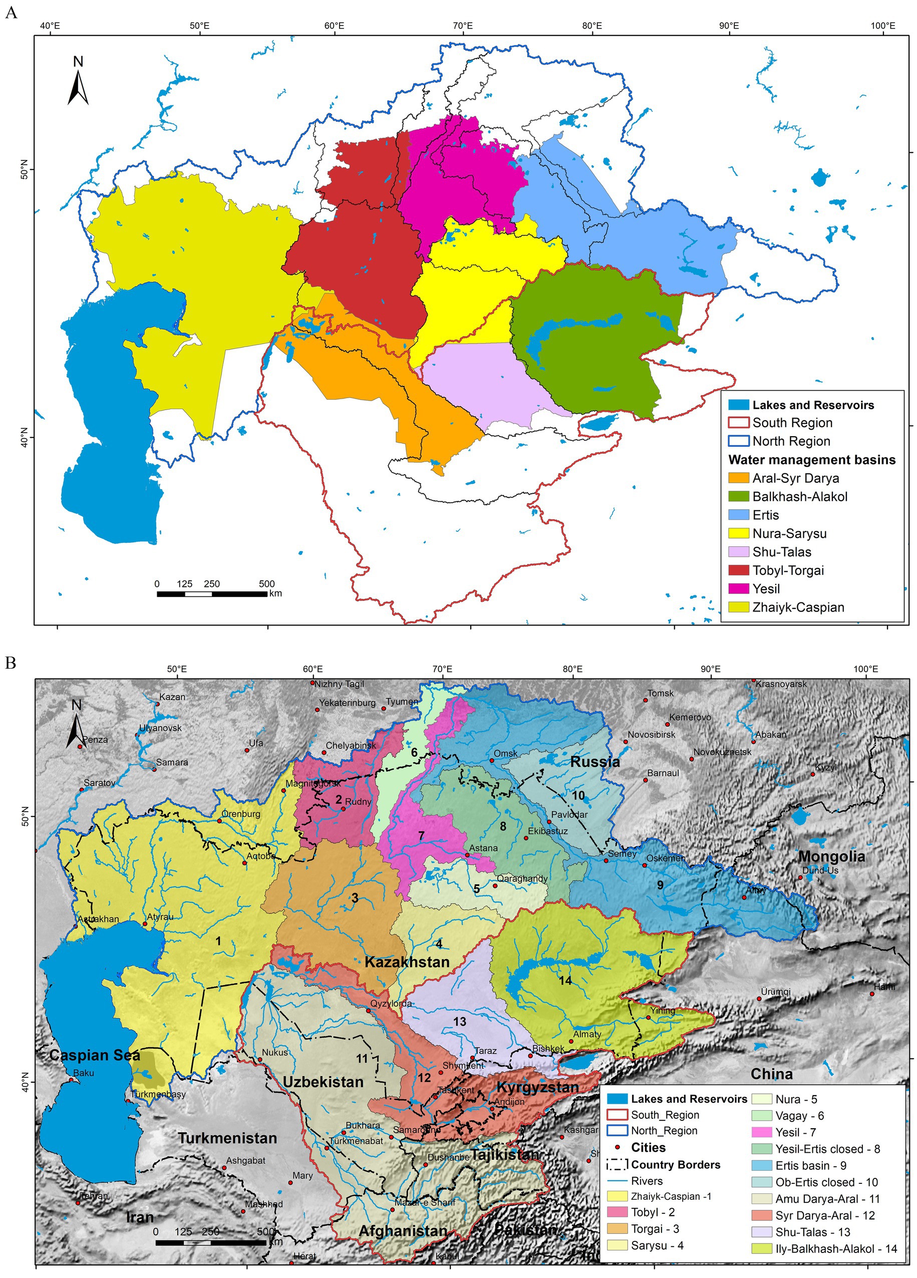
Figure 1. (A) The map of eight Kazakh national water management basins: Aral-Syr Darya, Balkhash-Alakol, Ertis, Nura-Sarysu, Shu-Talas, Tobyl-Torgai, Yesil, Zhaiyk-Caspian within North and South hydrological regions and (B) the regional river basins of Kazakhstan. North region: (1) Zhaiyk-Caspian, (2) Tobyl, (3) Torgai, (4) Sarysu, (5) Nura, (6) Vagay, (7) Yesil, (8) Yesil-Ertis closed basin, (9) Ertis (10) Ob-Ertis closed basin. South Region: (11) Amu Darya-Aral, (12) Syr Darya-Aral, (13) Shu-Talas, (14) Ily-Balkhash-Alakol. Basin boundaries are based on HydroAtlas (levels 3–5) (Linke et al., 2019). The physical data are from Natural Earth (2018) and the river network is from Global Runoff Data Centre (GRDC) (2020). The polygons of the water management basins and regional river basins are deposited Zenodo data repository (Yapiyev et al., 2025).
2.2.2 Regional hydrological basins
Regionally, the Kazakh river basins can be separated into two distinct hydrologic areas: Northern Kazakhstan that includes Zhaiyk-Caspian, Tobyl, Torgai, Nura, Sarysu, Yesil, Vagay and Ertis basins, along with additional closed inter-basins; and Southern Kazakhstan comprising the Syr Darya-Aral, Amu Darya-Aral, Shu-Talas and Ily-Balkhash-Alakol basins (Figure 1B and Table 1). In essence, this division can be extended to Central Asia, thus dividing it into North Central Asia (NCA) and South Central Asia (SCA) (see Figure 1 and Table 1). In the northern, Kazakhstan shares transboundary rivers with Russia, covering a total basin drainage area of approximately 2.7 million km2, while in the south, it shares rivers with Turkmenistan, Uzbekistan, Kyrgyzstan, and China with a total drainage area of approximately 1.8 million km2 (Figure 1B and Table 1). Notably, the main Ertis River watershed is unique, with its upper part in China, the main river course in Kazakhstan, and the downstream part in Russia (Figure 1B). These rivers traverse diverse geographical regions, with significant elevation differences between northern and southern areas (Table 1). Southern basins, such as the Amu Darya-Aral, are situated at higher elevations and ranging from −35 m to a peak of 7,447 m above sea level. In contrast, the northern basins, such as Ertis and Nura River basins have lower elevation range from −230 m to 4,306 m a.s.l and feature a generally flatter landscape (Table 1). The Ural Mountains serve as a major divide in the north, separating Zhaiyk-Caspian basin, which flow southward to the Caspian Sea, from eastern basins. Here, rivers flow northwards (with the exception of Togai, Nura and Sarysu Rivers that flow southwest) ultimately reaching the Kara Sea through Ob-Ertis or terminating in inland sinks. In the south, the Tien-Shan and Pamir Mountain systems are the headwaters of the Aral Sea basin (Amu and Syr Darya rivers), with smaller Shu-Talas and Ily-Balkhash basins draining to the northeast, ending in deserts or large dryland lakes (Figure 1B).3 The next section will elaborate on climatological, biophysical and ultimately hydrological characteristics that define this regionalization. Table 1 provides the main river basins characteristics.
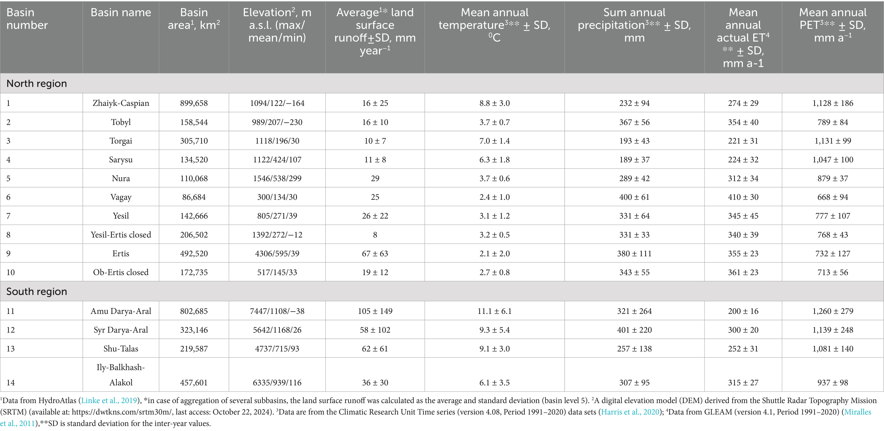
Table 1. Basin characteristics of Kazakhstan.
2.3 Hydroclimatology and river regimes
2.3.1 Climatological characteristics
The region’s climate is generally characterized by cold and dry conditions, with seasonal variations in air temperature (Ta) (Figures 2–4 and Table 1). Both the northern and southern areas experience cold winters with temperatures dropping below −20°C (Figure 2A) and hot summers with temperatures exceeding +20°C (Figure 2B). Precipitation (P) shows strong spatial variability and sharp spatial and altitudinal gradients, with the highest amounts (over 1,000 mm/year) in Tien-Shan and Pamir water towers (Figure 2C). High temperatures cause increased evaporation during warmer seasons (Supplementary Figure S1). Potential evaporation (PET) can exceed 1,500 mm/year in the lower parts of the Amu Darya-Aral basin (Figure 2D).
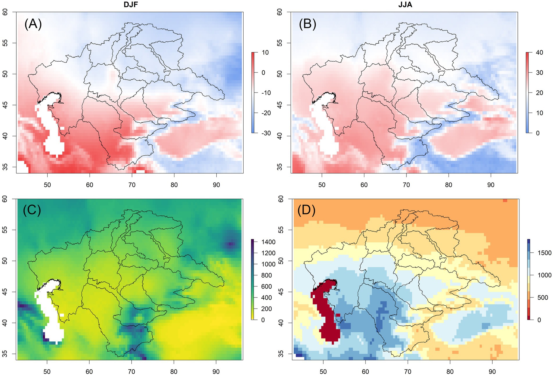
Figure 2. Climatological maps (A) winter air temperature (°C), (B) summer air temperature (Ta, oC), (C) annual precipitation (P, mm/year) and (D) annual potential evaporation (PET, mm/year). The data are from the Climatic Research Unit Time series v4.08 data sets (Harris et al., 2020). The lines are large regional catchment boundaries (see Figure 1B).
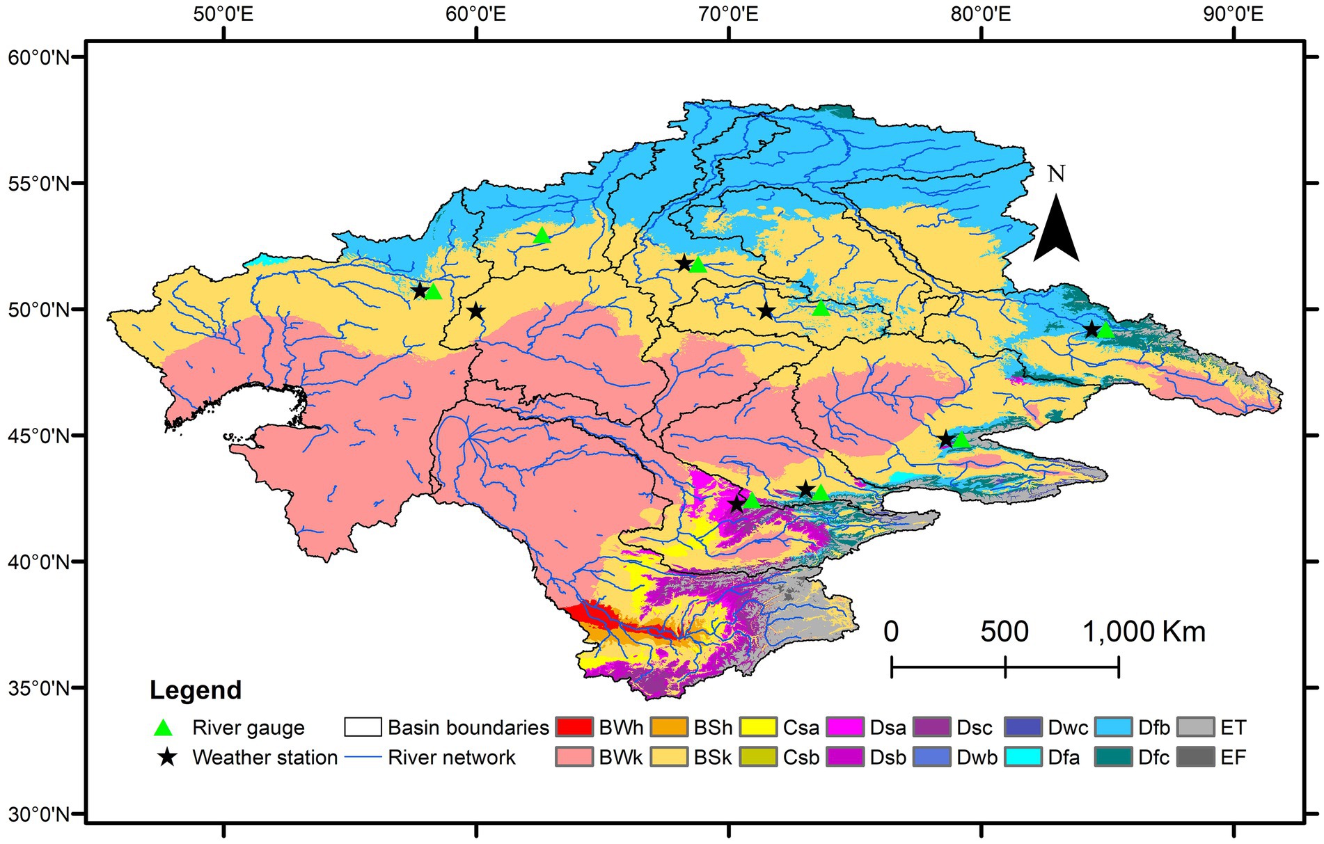
Figure 3. Koppen-Geiger Climate zones of Kazakhstan regional river basins. Description of zones: BWh - Arid, desert, hot; BWk - Arid, desert, cold; BSh - Arid, steppe, hot; BSk - Arid, steppe, cold; Csa -Temperate, dry summer, hot summer; Csb - Temperate, dry summer, warm summer; Dsa - Cold, dry summer, hot summer; Dsb - Cold, dry summer, warm summer; Dsc - Cold, dry summer, cold summer; Dwb - Cold, dry winter, warm summer; Dwc - Cold, dry winter, cold summer; Dfa - Cold, no dry season, hot summer; Dfb -Cold, no dry season, warm summer; Dfc - Cold, no dry season, cold summer; ET - Polar, tundra; EF - Polar, frost. Data from (Beck et al., 2023). The location of weather stations and river gauges for data shown on Figure 4 (see also Supplementary Table S1). Black line are regional river boundaries within North–South regions (Figure 1B), the river network is from Global Runoff Data Centre (GRDC) (2020).
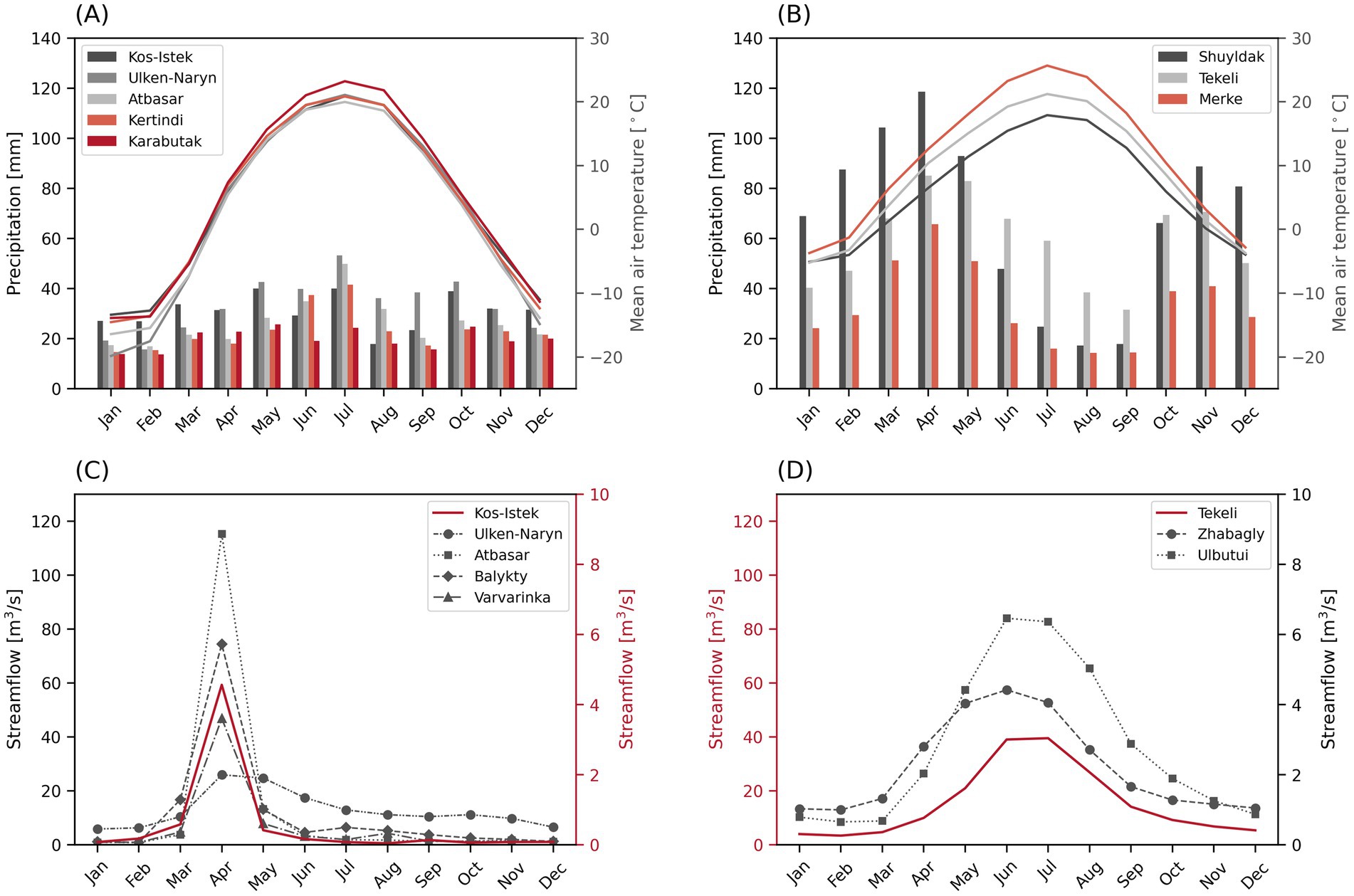
Figure 4. Seasonal cycles of mean air temperature (Ta), precipitation (P) and river streamflow (Q) from a selected representative basins: mean monthly Ta (lines) and P (bars) for North (A) and South (B) Regions; mean monthly Q for headwater rivers in the North (C) and South (D) Regions. Data from Kazhydromet (2000–2022 period). Weather stations and discharge gauge’s location data are presented in Figure 3 and in Supplementary Table S1. The detailed statistics for Ta, P, Q can be found in the Supplementary Tables S2–S7.
Mean annual PET and its variations across the northern and southern river regions generally correspond to changes in Ta (Table 1 and Supplementary Figure S1). For example, the Zhaiyk-Caspian basin in the north has the highest mean Ta of 8.8°C, coinciding with the highest PET of 1,128 ± 186 mm a−1. Similarly, the Amu Darya-Aral basin in the south has the highest Ta (11.1 ± 6.1°C) alongside the highest PET (1,260 ± 279 mm a−1). The wider Ertis river basin, with its tributaries (Tobyl, Yesil, Vagay) and internal drainage areas (basin numbers 5, 8, and 10, see Figure 1B), have a similar hydroclimate with average Ta ranging from 2.1 ± 2.0°C (Ertis) to 3.7 ± 0.7°C (Tobyl), and annual P totals are from 331 ± 64 mm (Yesil) to 380 ± 111 mm (Ertis), with high PET (~700–900 mm/year). Dry central basins in the northern Torgai and Sarysu basins have Ta around 6–7°C, approximately 200 mm of annual P, and PET over 1,000 mm/year.
In the south, there is greater variability in all hydroclimatic parameters due to large elevation gradients (Figure 2 and Table 1). Mean Ta increases from east to west, from about 6°C in Ily-Balkhash-Alakol to around 11°C in Amu Darya-Aral. The Shu-Talas basin, situated between the Aral Sea and Ily-Balkhash basins, lies in the rain shadow of the Karatau ridge and receives less P (257 ± 138 mm/year). In the Aral Sea basin, Syr Darya and Amu Darya watersheds had higher P: 401 ± 220 mm/year and 321 ± 264 mm/year, and PET 1139 ± 248 mm/year and 1,260 ± 279 mm/year, respectively.
Despite the high annual PET, the actual evapotranspiration (ET) is limited by precipitation. It ranges from 200 ± 16 mm/year in Amu Darya-Aral in the South (highest PET), to 400 ± 61 mm/year in the transboundary Vagay river basin in the North (Table 1 and Supplementary Figure S1).
2.3.2 Koppen-Geiger climate zones
Koppen-Geiger climate classification system facilitates the mapping of biome distribution based on threshold values and seasonality of monthly temperature and precipitation (Peel et al., 2007). In general, cold dry zones dominate the transboundary regions of Kazakhstan and CA, with a clear longitudinal zonal distribution (Figure 3). The northern area is mainly covered by cold, no dry season, warm summer zone (Dfa), which transitions to an arid, cold steppe (BSk) in the northern-central part of the region. Moving south and south-west, this zone is replaced by arid, cold desert (BWk). Compared to the northern basins (except Ertis), the southern basins display high heterogeneity in their upstream areas, which can be attributed to the presence of mountains, glaciers, and a greater elevational gradient.
2.3.3 Seasonal cycles of air temperature, precipitation and river streamflow. Surface runoff
CA is significantly affected by pronounced climate and hydrological seasonality. Figure 4 shows the seasonal cycles of mean Ta, P, and river streamflow (Q) in representative headwater basins in the northern and southern regions (data pertains to the Kazakh territory, with station locations depicted in Figure 3 and see also Supplementary Tables S1–S7). Weather station based climatology shows values similar to Climatic Research Unit (CRU) time series (Figure 2 and Table 1, Harris et al., 2020). Based on station data, the mean annual Ta in the northern basins was 4°C, while in the southern basins, it was 9°C (Supplementary Tables S2, S3). In the northern basins, the monthly mean Ta reached its lowest at −16°C in January and its highest at 21°C in July (Supplementary Table S2). In southern basins the lowest and highest Ta were observed in January and July, with values ranging from −5°C to 22°C, respectively (Figures 4A,B and Supplementary Table S3).
The total mean annual precipitation was 322 mm for the northern basins and 643 mm for the southern basins (Supplementary Tables S4, S5). In the northern basins (Figure 4A), P is more evenly distributed, with the highest values occurring in May and June, usually peaking in July. Specifically, the Atbasar (50 mm/month), Kertindi (42 mm/month), and Ulken-Naryn (53 mm/month) weather stations show precipitation peaks in July, while the Karabutak (26 mm/month) and Kos-Istek (40 mm/month) stations peak in May (Supplementary Table S4). In contrast, all weather stations in Southern basins (Figure 4B) show precipitation peaks during the spring months of March, April, and May, with the highest values recorded in April. Specifically, precipitation values reached 119 mm/month in Shuyldak, 85 mm/month in Tekeli, and 66 mm/month in Merke (Supplementary Table S5). The lowest p values for the northern basins occurred in January and February, averaging 19 mm/month and 18 mm/month, respectively, whereas the southern basins recorded their lowest values in August and September, with 23 mm/month and 21 mm/month, respectively (Supplementary Tables S4, S5).
Streamflow in the north peaks in April and May (Figure 4A and Supplementary Table S6), corresponding to the snowmelt period (nival river regime). In April, the Atbasar (Yesil) station recorded the highest streamflow among the northern basins, reaching 115 m3/s (78% of the annual streamflow). This was followed by the Balykty (Nura basin) station at 74 m3/s (56% of the total annual discharge) (Supplementary Table S6). The highest total annual Q in the Northern basins was observed in the Ulken-Naryn (Ertis basin) station (153 m3/s), while the lowest was recorded at the Kos-Istek (Zhaiyk river basin) station (Supplementary Table S6). In contrast, streamflow in the South region peaks during the summer months of June, July and August (Figure 4D) corresponding to snow and glacier melt (Shahgedanova et al., 2018). The Tekeli (Ily-Balkhash basin) station recorded the highest total annual Q, at 185 m3/s and a July peak of 40 m3/s (Supplementary Table S7). Total mean annual Q values at Ulbutui and Zhabagly (Shu-Talas basin) stations were similar, at 33 and 27 m3/s, respectively, with June peaks of 6.5 and 4.4 m3/s (Supplementary Table S7). Both northern and southern basin stations showed the lowest streamflow during January and February, with values under 2 m3/s (Supplementary Tables S6, S7).
The relatively modest precipitation and high PET result in relatively small land surface runoff (R), as all precipitation in warm (vegetative) periods is consumed in evaporation (Table 1). Overall, the basin-wide average runoff is smallest in the north region with high variability relative to annual mean values (Table 1). It is smallest (~ 10 mm/year) in the dry Torgai and Sarysu basins in the center of the region, which are usually considered arheic (Meybeck, 2009) and Yesil-Ertis closed basin (8 mm/year). The rest of the north has average runoff values from 16 mm/year in Zhaiyk-Caspian and Tobyl to 67 mm/year in the main Ertis River basin. In the southern region surface runoff varies from 36 ± 30 mm/year for Ily-Balkhash-Alakol to 105 ± 149 mm/year for Amu Darya-Aral (Table 1). This runoff is dominated by glacierized headwaters.
2.4 Land cover
The study area is predominantly covered by grasslands, accounting for approximately 60% of the land cover (Figure 5 and Supplementary Table S7). Cropland and bare/sparse vegetation zones together cover more than a quarter of total land area. As with the case of Koppen-Geiger climate zones, there is a clear zonal distribution of land cover types. Widespread tree cover and herbaceous wetlands are observed mainly in the most northern parts, gradually transitioning to croplands as one moves south. The usual pattern of rain-fed croplands seen in northern basins interrupted by the Yesil-Ertis closed basin. The central part of the region is dominated by grasslands, while the arid, cold desert Koppen-Geiger zone corresponds to bare/sparse vegetation land cover types. In comparison to northern basins, croplands in southern basins do not have latitudinal zones but are mostly concentrated along the main river networks, as they fully depend on them during growing periods as summer precipitation amounts are low.
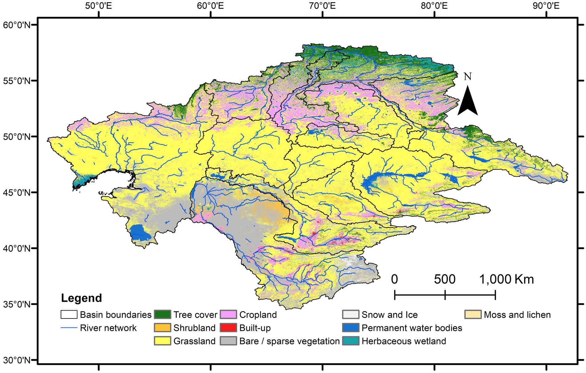
Figure 5. Land cover map of the Kazakhstan regional river basins. Data from ESA WorldCover 2020 v200 (Zanaga et al., 2022). See also Supplementary Table S8 for zonal basin statistics. Basin boundaries are the same as on Figure 1B and the river network is from Global Runoff Data Centre (GRDC) (2020).
3 Discussion
In the seminal work on regional climate modeling Mannig et al. (2013) divided Central Asia into eight subregions. The main clusters covering selected region are Northern CA (NCA, mean Ta and total P of 2.6°C and 346 mm/year, with P peaking in July), miscellaneous transition zones (mean Ta and total P of 8.4°C and 304 mm/year, with P peaking in March), arid basins of CA (mean Ta and total P of 9.8°C and 119 mm/year, with uniform P distribution). Jiang et al. (2020) separated CA into northern and southern areas based on the same seasonality principles (Figures 4A,B). In the latest IPCC report (IPCC, 2021) the CA region is presented in four subregions: Eastern Europe (EEU), Western Siberia (WSB), Western Central Asia (WCA), and Eastern Central Asia (ECA). These differences between different approaches to regionalization also shows that Kazakhstan and Central Asia are not an independent uniform region but is embedded in other regions (Yapiyev et al., 2017a). For example, geographically, the Ural (Zhaiyk) river is considered to be a European river (Yarushina et al., 2009; Keune and Miralles, 2019) and Ertis is the largest tributary of the Ob River in Siberia (Yapiyev et al., 2017a; Huang et al., 2021). The eastern part of the Caspian basin (Figure 1B) is an inland sink of the Murghab-Harirud river system that territorially can be considered to be in the Middle East (Marti et al., 2023; Fallah et al., 2024).
The arid zone of CA and Kazakhstan is located in the cold and dry desert zone (BWk zone in Koppen-Geiger, Figure 3) with seasonally uniform precipitation. However, in the Northen – Southern classification, the Northern Kazakhstan rivers situated in this zone, such as Zhem (Emba) in Zhaiyk-Caspian (Laiskhanov et al., 2025), Torgai and Sarysu have the nival (snow-dominated) flow regime (Figure 4C). In contrast, the arid lowlands of the south region, including the Aral Sea basin, Shu-Talas and Ily-Balkhash (Figure 1B), are dominated by discharges in mountain headwaters with nival-glacial river regimes (Figure 4D). According to Beckinsale (2021) river regime classification, the study region (Figure 1B) belongs to microthermal (one or more months with mean temperatures below −3 C0, and snow cover duration for a month or more) and mountain regimes (microthermal regimes on high mountains, above 1,500 m a.s.l,). In this classification, the North region has microthermal regime Dfc (violent nival spring maximum, strong winter minimum) and the South region belongs to mountains regimes HN (nivale or highland snow) and HG (gletscher or highland ice). In Soviet classification Kazakhstan was predominantly classified to have spring flood type and warm season high-flow in the mountain regions (Zaikov, 1946).
This river basin classification has significant implications for water research and management in Kazakhstan and Central Asia. Similar to Yao et al.’s (2021) approach, Central Asia was classified into Northern (NCA), Southwestern (SWCA), and Southeastern (SECA) subregions based on Köppen-Geiger zones, aridity index, precipitation distribution, geomorphological landscapes, and land cover conditions. This classification helped assess extreme precipitation, forecasted to increase in the region until the end of the century, with the largest changes in NCA and SECA. Studies on climatology and moisture sources in precipitation in Central Asia were aided by similar regionalization (Jiang et al., 2020; Peng et al., 2020, 2024).
In terms of agricultural water management, the North Region is dominated by rain-fed agriculture (Figure 5), mostly grains (Schierhorn et al., 2020), relying on summer rain and spring snowmelt for soil moisture replenishment (Li et al., 2020). Crops in the South Region (Figure 5) fully rely on irrigation during the vegetation period in summer; the water is provided from river with glaciated headwaters (Li et al., 2020). Both regions rely on the dominance of grasslands for livestock farming (Chen T. et al., 2019) (Figure 5). The crucial difference in agriculture implies different approaches to water management and climate change adaptation (Li et al., 2020). It was estimated that in the rain-fed North under 2.0°C warming scenario increase in precipitation will not be sufficient to meet crop water requirements in the period by end of the century (Li et al., 2020). This will require development of drought resistant crops and adoption of wider use of climate-resilient irrigation. Decreased runoff from glacierized headwaters in the South, will require incremental (such as improvement in existing irrigation systems) and transformative (drip irrigation technologies, self-organized governance system) adaptation actions (Saidaliyeva et al., 2024).
Flood risk management and mitigation differ significantly between the North and South regions. In the Northern part, the spring snowmelt flooding is a natural hazard resulting from the natural river regime (Figure 4C) and is exacerbated by climate change impacts, such as earlier and more pronounced spring flood peaks (Didovets et al., 2024). The catastrophic snowmelt flood in spring 2024 that affected the Northern region, including southwestern Russia, and north and northwest Kazakhstan. The event was compounded by record high snowmelt, antecedent soil moisture anomalies, extreme rainfall, and high air temperatures in March 2024 (Laiskhanov et al., 2025; Zhang et al., 2025). Evidence suggests that settlement expansion in flood-prone zones played an important role in the 2024 flood disaster (Laiskhanov et al., 2025), aligning with global trends (Rentschler et al., 2023). In the South, common flood hazards include glacial lake outburst floods, pluvial floods from extreme precipitation, intense glacial-snowmelt events and related debris flows and landslides (Kapitsa et al., 2017; Saidaliyeva et al., 2024; Shahgedanova et al., 2024). Thus, flood risk assessments, adaptation, and mitigation measures must account for such regional differences (Ceresa et al., 2025). For example, the AI flood forecasting tool recently developed by Google (Nearing et al., 2024) must be adapted differently for the North and the South of Kazakhstan. Addressing the geohazards and climate risks in both regions will require multi-sectoral approaches including land and water management, early-warning systems and capacity building, and improved monitoring (Yapiyev et al., 2017a; Saidaliyeva et al., 2024; Shahgedanova et al., 2024), taking into account regional differences.
The proposed water resources framework for Kazakhstan directly supports efforts toward achieving the Sustainable Development Goals (SDGs), particularly: SDG 6 (Clean Water and Sanitation) SDG 13 (Climate Action), SDG 2 (Zero Hunger), and SDG 15 (Life on Land). Regionalization reveals crucial differences in climate change adaptation needs across Kazakhstan’s Northern and Southern hydrological regions (SDG 13). Understanding regional hydrological characteristics is essential for developing effective strategies to combat climate change and its impacts on water resources (SDG 6). The identified differences in agricultural water management between the rain-fed North and irrigation-dependent South regions stress the need for tailored approaches to ensure food security and sustainable agriculture (SDG 2). While achieving human-centered SDGs is important, the growing body of research on the region (Saidaliyeva et al., 2024; Song et al., 2025) emphasizes the importance of water resources for ecosystem sustainability and ecological conservation (SDG 15). The detailed basin-level transboundary approach is better suited for the protection, restoration, and promotion of sustainable use of terrestrial ecosystems. Baseline basin information and characteristics are essential for setting the hydrologically relevant boundary conditions (Tarasova et al., 2024). Catchment regionalization has already proved to be essential to conduct global, regional and local water research (Meybeck et al., 2013; Pool et al., 2021; Zhao et al., 2024; Kiraz-Safari et al., 2025). Such background information can serve as a starting point for setting and exploring one’s research hypotheses and questions (Wade et al., 2024; Zhao et al., 2025) and for countries to engage in climate-proofed water agreements.
4 Knowledge gaps and future work
Overall, current and future water availability and quality are the most important knowledge gaps in Kazakhstan and wider Central Asia. Our data and the wider literature show that the region is historically climatologically water-limited and climate change makes accurate future predictions even more difficult. Moreover, it is not addressed in detail in terms of impacts and adaptation (Vakulchuk et al., 2022; Saidaliyeva et al., 2024). While transboundary water sharing and management has been a hot point for discussion in the South region, the North basins shared with the Russian Federation are still largely ignored. Apart from water availability, water quality is also a pressing issue. There is growing interest in the South (e.g., Yapiyev et al., 2021; Wade et al., 2024), but larger areas in the North have less data and research projects.
Groundwater presents a potentially untapped reserve to compensate water deficits during droughts but has the largest knowledge gap (Gafurov et al., 2019; Yapiyev et al., 2021). Groundwater sustains river flows, especially during dry periods (Xie et al., 2024) but very little is known about the links between surface and groundwater flows (Yapiyev et al., 2020). Hydrogeological regionalization for Kazakhstan and Central Asia was developed in the Soviet period (e.g., Lagutin, 2020), yet, little progress in groundwater research was achieved thereafter. A recent study (Sallwey, 2024) has shown that Kazakhstan has high potential for implementing managed aquifer recharge (MAR) systems but more in-depth research is needed. Kazakhstan and Central Asia is the region with the most expansive groundwater-dependent ecosystems (Rohde et al., 2024) but yet little is known about water movement in the subsurface and ecohydrology (plant water use).
Recent literature reviews (Yapiyev et al., 2021; Saidaliyeva et al., 2024) show that water security is a dominant topic, while freshwater ecosystems and biodiversity (Song et al., 2025) are underrepresented in the scientific literature for the region. Kazakhstan and Central Asia are dominated by non-perennial streams (Messager et al., 2021; Krabbenhoft et al., 2022). This results in a high degree of endorheism (Yapiyev et al., 2017a) even in the river basins connected to ocean outlets are embedded regions with inland sinks (Figure 1B). Studying regional hydrology and water resource management must take into account the presence of such closed drainage areas (Prusevich et al., 2024). Endorheic areas are water-scarce, thus, the possibility to do economic activities is very limited; furthermore, these regions are also very sensitive to climatic changes (Yapiyev et al., 2024). Nevertheless, the available topography data such as Digital Elevation Models have at best 25 m spatial resolution (Hawker et al., 2022), which often is not sufficient for hydrological modeling tasks such as flood forecasting and risk assessment, especially for relatively flat regions in the north (Table 1).
The region has experienced an increase in both population and urbanization, but urban water infrastructure and management practices are still inadequate to deal with residential floods and other natural hazards, as well as to propose climate change adaptation in the cities (Laiskhanov et al., 2025). Soil hydrology has been receiving increased attention in recent years (Yapiyev et al., 2018; Siegfried et al., 2024) but together with groundwater is also mostly unexplored topic.
Snow (and snowmelt) is the most critical resource for water supply and quality of both surface water, soil moisture and groundwater (Mashtayeva et al., 2016; Fugazza et al., 2020; Khanal et al., 2021). Nevertheless, snow related hydrological processes and their representation in hydrological models are yet poorly captured and researched.
Another knowledge gap relevant to Kazakh and Central Asian hydrological studies is the lack of knowledge on runoff formation processes and runoff components. Assessment of seasonal contribution of runoff components is necessary to understand runoff formation mechanisms and the dynamics of water resources, to estimate the influence of climate change on water regime and to develop adaptation strategies in addition to management plans. There is a limited number of studies which directly address hydrograph separation of South Central Asian rivers considered in this work, such as Ala-Archa river (He et al., 2018, 2020; Tokarev et al., 2024), Naryn River (Hill et al., 2017), Syrdarya and Amudarya (Khanal et al., 2021). While the majority of studies on hydrograph separation for Central Asian region focus on the rivers in the Chinese part of Central Asia, such as Urumqi river (Sun et al., 2016), Tarim River Basin (Fan et al., 2016; Sun et al., 2018), river runoff in Tianshan Mountains (Chen H. et al., 2019). Overall, results indicate that meltwater (from snow and glacier) and groundwater comprise a significant portion of annual runoff. While the glacier (melt) contribution is often emphasized as important for surface water resources in glaciarized catchments of South region (Pritchard, 2019; Tillakarim et al., 2024), snowmelt (Kraaijenbrink et al., 2021) and groundwater (Khanal et al., 2021) are the main contributors to the total runoff. Literature review highlights the absence of such studies for the Northern Kazakh river basins, which are especially reliant on winter snowpack for runoff generation.
Water research studies and development of underlying theories, concepts, process formalization are based on results from data-rich Europe, North America, China and Australia (Kratzert et al., 2023; Tarasova et al., 2024). Accordingly, the applicability of modelling tools for Kazakhstan is often quite limited. For example, relatively recently published exercise of application of the global hydrological model World-Wide HYPE, has explicitly stated that the model failed to represent hydrographic situation in CA basins (Arheimer et al., 2020). Emerging AI modeling approaches can also be leveraged for hydrological modeling (e.g., Kratzert et al., 2018), drought and flood forecasting, and other related environmental approaches in Kazakhstan, but this will require better access to ground observations, and proper set-up and model training taking into account regional features.
5 Final remarks
Water and related environmental studies for Central Asia and Kazakhstan often rely on national country borders as boundary conditions (e.g., Hu et al., 2021). This limits the validity and practical applicability of such works. While considering Central Asia, the research domains are either limited to national boundaries in Kazakhstan, Uzbekistan, Turkmenistan, Kyrgyzstan, sometimes together with Northwest China (or the Tarim basin). This division constitutes only the South Region or South Central Asia (SCA), while ignoring transboundary rivers shared by Kazakhstan and Russia in the North which can be considered Northen Central Asia (NCA) (Mannig et al., 2013; Yapiyev et al., 2017b). The focus of international studies and projects has a strong SCA focus such as mountains (e.g., Saidaliyeva et al., 2024), glaciers (Kapitsa et al., 2020), water policy (Menga, 2017) and Aral Sea basin (Xenarios et al., 2019). On the other hand, the projects funded in Kazakhstan are usually have strong national focus. We tried to show that for Kazakhstan and Central Asia water, climate and environmental research and management activities require on one hand more nuanced and on the other broader approaches, taking into account the hydrological, climatological and biophysical boundaries, instead of narrower ‘national borders’. Such approaches must consider specific regional traits such as seasonality of water and climate cycle, land cover and biome zonation. This will allow us to address quickly changing change and related challenges of the 21st century.
Author contributions
VY: Conceptualization, Investigation, Writing – review & editing, Data curation, Supervision, Methodology, Funding acquisition, Resources, Project administration, Visualization, Formal analysis, Writing – original draft, Validation. NO: Visualization, Data curation, Methodology, Formal analysis, Conceptualization, Writing – original draft, Writing – review & editing, Investigation, Funding acquisition. ZS: Investigation, Visualization, Formal analysis, Validation, Data curation, Conceptualization, Methodology, Writing – review & editing. AZ: Data curation, Investigation, Methodology, Visualization, Writing – original draft. TS: Writing – original draft, Writing – review & editing, Investigation. MB: Writing – review & editing. EP: Visualization, Writing – review & editing.
Funding
The author(s) declare that financial support was received for the research and/or publication of this article. This research was funded by the Science Committee of the Ministry of Science and Higher Education of the Republic of Kazakhstan (grant no. AP23489867).
Acknowledgments
We would like to thank Kazhydromet for providing hydrometeorological data. We would like to thank Charles Gilman for the review of the manuscript.
Conflict of interest
The authors declare that the research was conducted in the absence of any commercial or financial relationships that could be construed as a potential conflict of interest.
Generative AI statement
The author(s) declare that Gen AI was used in the creation of this manuscript. NotebookLM, a generative AI platform, was used by VY to improve the readability of the manuscript. After using this tool, the author reviewed and edited the content as needed and takes full responsibility for the content.
Publisher’s note
All claims expressed in this article are solely those of the authors and do not necessarily represent those of their affiliated organizations, or those of the publisher, the editors and the reviewers. Any product that may be evaluated in this article, or claim that may be made by its manufacturer, is not guaranteed or endorsed by the publisher.
Supplementary material
The Supplementary material for this article can be found online at: https://www.frontiersin.org/articles/10.3389/frwa.2025.1601671/full#supplementary-material
Footnotes
1. ^https://www.rshu.ru/university/history/
2. ^https://www.kazhydromet.kz/ru/gidrologiya/ezhegodnye-dannye-o-rezhime-i-resursah-poverhnostnyh-vod-sushi-eds
3. ^We exclude basins that do not have part of its territory in Kazakhstan, such as the endorheic Issyk-Kyl Lake in Kyrgyzstan and Tarim in China (Yapiyev et al., 2021), but do include Amu Darya.
References
Alekin, O. A., and Brazhnikova, L. V. (1964). Runoff of dissolved substances from the USSR territory. Moscow: Nauka.
Arheimer, B., Pimentel, R., Isberg, K., Crochemore, L., Andersson, J. C. M., Hasan, A., et al. (2020). Global catchment modelling using world-wide HYPE (WWH), open data, and stepwise parameter estimation. Hydrol. Earth Syst. Sci. 24, 535–559. doi: 10.5194/hess-2-0.35-2020
Beck, H. E., McVicar, T. R., Vergopolan, N., Berg, A., Lutsko, N. J., Dufour, A., et al. (2023). High-resolution (1 km) Köppen-Geiger maps for 1901–2099 based on constrained CMIP6 projections. Sci Data 10:724. doi: 10.1038/s41597-023-02549-6
Beckinsale, R. P. (2021). “River regimes” in Water, earth, and man. ed. R. Chorley (London: Routledge), 455–471.
Ceresa, P., Bussi, G., Denaro, S., Coccia, G., Bazzurro, P., Martina, M., et al. (2025). Large-scale flood risk assessment in data-scarce areas: an application to Central Asia. Nat. Hazards Earth Syst. Sci. 25, 403–428. doi: 10.5194/nhess-25-403-2025
Chen, Y., Li, Z., Fang, G., and Li, W. (2018). Large hydrological processes changes in the transboundary Rivers of Central Asia. J. Geophys. Res. Atmos. 123, 5059–5069. doi: 10.1029/2017JD028184
Chen, H., Chen, Y., Li, W., and Li, Z. (2019). Quantifying the contributions of snow/glacier meltwater to river runoff in the Tianshan Mountains, Central Asia. Glob. Planet. Change 174, 47–57. doi: 10.1016/J.GLOPLACHA.2019.01.002
Chen, T., Bao, A., Jiapaer, G., Guo, H., Zheng, G., Jiang, L., et al. (2019). Disentangling the relative impacts of climate change and human activities on arid and semiarid grasslands in Central Asia during 1982–2015. Sci. Total Environ. 653, 1311–1325. doi: 10.1016/j.scitotenv.2018.11.058
Deng, H., and Chen, Y. (2017). Influences of recent climate change and human activities on water storage variations in Central Asia. J. Hydrol. 544, 46–57. doi: 10.1016/J.JHYDROL.2016.11.006
Didovets, I., Lobanova, A., Krysanova, V., Menz, C., Babagalieva, Z., Nurbatsina, A., et al. (2021). Central Asian rivers under climate change: impacts assessment in eight representative catchments. J. Hydrol. Reg. Stud. 34:100779. doi: 10.1016/j.ejrh.2021.100779
Didovets, I., Krysanova, V., Nurbatsina, A., and Fallah, B. (2024). Attribution of current trends in streamflow to climate change for 12 central Asian catchments. Clim. Chang. 177:3673. doi: 10.1007/s10584-023-03673-3
Dobroumov, G. G. (editor) (1973). The surface water resources of USSR. Vol. 14. Issue 2. Central Asia. Gidrometizdat: The basins of Issyk-Kul Lake and Chu, Talas and Tarim Rivers.
Fallah, B., Didovets, I., Rostami, M., and Hamidi, M. (2024). Climate change impacts on Central Asia: trends, extremes and future projections. Int. J. Climatol. 44, 3191–3213. doi: 10.1002/joc.8519
Fan, Y., Chen, Y., He, Q., Li, W., and Wang, Y. (2016). Isotopic characterization of river waters and water source identification in an Inland River. Central Asia. Water 8:286. doi: 10.3390/w8070286
Fugazza, D., Shaw, T. E., Mashtayeva, S., and Brock, B. (2020). Inter-annual variability in snow cover depletion patterns and atmospheric circulation indices in the upper Irtysh basin, Central Asia. Hydrol. Process. 34, 3738–3757. doi: 10.1002/hyp.13843
Gafurov, A., Yapiyev, V., Ahmed, M., Sagin, J., Haghighi, A. T., Akylbekova, A., et al. (2019). “Groundwater resources” in The Aral Sea basin. eds. P. P. Micklin and W. D. Williams (London: Routledge), 39–51.
Global Runoff Data Centre (GRDC) (2020). WMO Basins and Sub-Basins. Koblenz: Global Runoff Data Centre (GRDC).
Harris, I., Osborn, T. J., Jones, P., and Lister, D. (2020). Version 4 of the CRU TS monthly high-resolution gridded multivariate climate dataset. Sci Data 7, 109–118. doi: 10.1038/s41597-020-0453-3
Hawker, L., Uhe, P., Paulo, L., Sosa, J., Savage, J., Sampson, C., et al. (2022). A 30 m global map of elevation with forests and buildings removed. Environ. Res. Lett. 17:24016. doi: 10.1088/1748-9326/ac4d4f
He, Z., Vorogushyn, S., Unger-Shayesteh, K., Gafurov, A., Kalashnikova, O., Omorova, E., et al. (2018). The value of hydrograph partitioning curves for calibrating hydrological models in Glacierized basins. Water Resour. Res. 54, 2336–2361. doi: 10.1002/2017WR021966
He, Z., Unger-Shayesteh, K., Vorogushyn, S., Weise, S. M., Duethmann, D., Kalashnikova, O., et al. (2020). Comparing Bayesian and traditional end-member mixing approaches for hydrograph separation in a glacierized basin. Hydrol. Earth Syst. Sci. 24, 3289–3309. doi: 10.5194/hess-24-3289-2020
Hill, A. F., Minbaeva, C. K., Wilson, A. M., Satylkanov, R., Hill, A. F., Minbaeva, C. K., et al. (2017). Hydrologic controls and water vulnerabilities in the Naryn River basin, Kyrgyzstan: a socio-hydro case study of water stressors in Central Asia. Water 9:325. doi: 10.3390/w9050325
Hu, Z., Zhang, Z., Sang, Y., Qian, J., and Feng, W. (2021). Temporal and spatial variations in the terrestrial water storage across Central Asia based on multiple satellite datasets and global hydrological models. J. Hydrol. 596:126013. doi: 10.1016/j.jhydrol.2021.126013
Huang, W., Duan, W., Nover, D., Sahu, N., and Chen, Y. (2021). An integrated assessment of surface water dynamics in the Irtysh River basin during 1990–2019 and exploratory factor analyses. J. Hydrol. 593:125905. doi: 10.1016/j.jhydrol.2020.125905
Jiang, J., Zhou, T., Wang, H., Qian, Y., Noone, D., and Man, W. (2020). Tracking moisture sources of precipitation over Central Asia: a study based on the water-source-tagging method. J. Clim. 33, 10339–10355. doi: 10.1175/JCLI-D-20-0169.1
Kapitsa, V., Shahgedanova, M., Machguth, H., Severskiy, I., and Medeu, A. (2017). Assessment of evolution and risks of glacier lake outbursts in the Djungarskiy Alatau, Central Asia, using Landsat imagery and glacier bed topography modelling. Nat. Hazards Earth Syst. Sci. 17, 1837–1856. doi: 10.5194/nhess-17-1837-2017
Kapitsa, V., Shahgedanova, M., Severskiy, I., Kasatkin, N., White, K., and Usmanova, Z. (2020). Assessment of changes in mass balance of the Tuyuksu Group of Glaciers, northern Tien Shan, between 1958 and 2016 using ground-based observations and Pléiades satellite imagery. Front. Earth Sci. 8:259. doi: 10.3389/feart.2020.00259
Keune, J., and Miralles, D. G. (2019). A precipitation recycling network to assess freshwater vulnerability: challenging the watershed convention. Water Resour. Res. 55, 9947–9961. doi: 10.1029/2019WR025310
Khanal, S., Lutz, A. F., Kraaijenbrink, P. D. A., van den Hurk, B., Yao, T., and Immerzeel, W. W. (2021). Variable 21st century climate change response for Rivers in High Mountain Asia at seasonal to decadal time scales. Water Resour. Res. 57, 1–26. doi: 10.1029/2020WR029266
Kiraz-Safari, M., Coxon, G., Rahman, M., and Wagener, T. (2025). Location, location, location – considering relative catchment location to understand subsurface losses. J. Hydrol. 646:132328. doi: 10.1016/j.jhydrol.2024.132328
Kraaijenbrink, P. D. A., Stigter, E. E., Yao, T., and Immerzeel, W. W. (2021). Climate change decisive for Asia’s snow meltwater supply. Nat. Clim. Chang. 11, 591–597. doi: 10.1038/s41558-021-01074-x
Krabbenhoft, C. A., Allen, G. H., Lin, P., Godsey, S. E., Allen, D. C., Burrows, R. M., et al. (2022). Assessing placement bias of the global river gauge network. Nat. Sustain. 5, 586–592. doi: 10.1038/s41893-022-00873-0
Kratzert, F., Klotz, D., Brenner, C., Schulz, K., and Herrnegger, M. (2018). Rainfall-runoff modelling using long short-term memory (LSTM) networks. Hydrol. Earth Syst. Sci. 22, 6005–6022. doi: 10.5194/hess-22-6005-2018
Kratzert, F., Nearing, G., Addor, N., Erickson, T., Gauch, M., Gilon, O., et al. (2023). Caravan - a global community dataset for large-sample hydrology. Sci Data 10:61. doi: 10.1038/s41597-023-01975-w
Kuchment, L., and Gelfan, A. (2024). Development of runoff generation models in the former USSR and Russia: a historical overview. Hydrol. Sci. J. 69, 2323–2336. doi: 10.1080/02626667.2024.2413013
Lagutin, E. I. (2020). Modern principles of typification of underground hydrosphere (in Russian). Available online at: https://ecogosfond.kz/wp-content/uploads/2021/06/CA.D.391-Sovremennye-principy-tipizacii-podzemnoi-gidrosfery-vnutrikontinentalnyh-orogenov-na-primere-Centralnoi-Azii.pdf (accessed June 21, 2021).
Laiskhanov, S., Sharapkhanova, Z., Myrzakhmetov, A., Levin, E., Taukebayev, O., Nurmagambetuly, Z., et al. (2025). Geo-ecological analysis of the causes and consequences of flooding in the Western region of Kazakhstan. Urban Sci. 9:20. doi: 10.3390/urbansci9010020
Li, Z., Fang, G., Chen, Y., Duan, W., and Mukanov, Y. (2020). Agricultural water demands in Central Asia under 1.5 °C and 2.0 °C global warming. Agric. Water Manag. 231:106020. doi: 10.1016/j.agwat.2020.106020
Linke, S., Lehner, B., Ouellet Dallaire, C., Ariwi, J., Grill, G., Anand, M., et al. (2019). Global hydro-environmental sub-basin and river reach characteristics at high spatial resolution. Sci Data 6:283. doi: 10.1038/s41597-019-0300-6
Mannig, B., Müller, M., Starke, E., Merkenschlager, C., Mao, W., Zhi, X., et al. (2013). Dynamical downscaling of climate change in Central Asia. Glob. Planet. Change 110, 26–39. doi: 10.1016/j.gloplacha.2013.05.008
Marti, B., Yakovlev, A., Karger, D. N., Ragettli, S., Zhumabaev, A., Wakil, A. W., et al. (2023). CA-discharge: geo-located discharge time series for mountainous Rivers in Central Asia. Sci Data 10:579. doi: 10.1038/s41597-023-02474-8
Mashtayeva, S., Dai, L., Che, T., Sagintayev, Z., Sadvakasova, S., Kussainova, M., et al. (2016). Spatial and temporal variability of snow depth derived from passive microwave remote sensing data in Kazakhstan. J. Meteorol. Res. 30, 1033–1043. doi: 10.1007/s13351-016-5109-z
Messager, M. L., Lehner, B., Cockburn, C., Lamouroux, N., Pella, H., Snelder, T., et al. (2021). Global prevalence of non-perennial rivers and streams. Nature 594, 391–397. doi: 10.1038/s41586-021-03565-5
Meybeck, M. (2003). “Global occurrence of major elements in Rivers” in Treatise on geochemistry. eds. K. K. Turekian and H. D. Holland (Amsterdam: Elsevier), 207–223.
Meybeck, M. (2009). “Asia – northern Asia and Central Asia endorheic Rivers” in Encyclopedia of inland waters. ed. T. Mehner (Amsterdam: Elsevier), 326–335.
Meybeck, M., Kummu, M., and Dürr, H. H. (2013). Global hydrobelts and hydroregions: improved reporting scale for water-related issues? Hydrol. Earth Syst. Sci. 17, 1093–1111. doi: 10.5194/hess-17-1093-2013
Miralles, D., Holmes, T. R. H., De Jeu, R. A. M., Gash, J. H., Meesters, A. G. C. A., and Dolman, A. J. (2011). Global land-surface evaporation estimated from satellite-based observations. Hydrology and Earth System Sciences. 30, 1033–1043. doi: 10.5194/hess-15-453-2011
Natural Earth (2018). Natural Earth. Available online at: http://www.naturalearthdata.com/ (accessed May 8, 2018).
Nearing, G., Cohen, D., Dube, V., Gauch, M., Gilon, O., Harrigan, S., et al. (2024). Global prediction of extreme floods in ungauged watersheds. Nature 627, 559–563. doi: 10.1038/s41586-024-07145-1
Ongdas, N., Akiyanova, F., Karakulov, Y., Muratbayeva, A., and Zinabdin, N. (2020). Application of HEC-RAS (2D) for flood Hazard maps generation for Yesil (Ishim) river in Kazakhstan. Water 12:2672. doi: 10.3390/w12102672
Peel, M. C., Finlayson, B. L., and McMahon, T. A. (2007). Updated world map of the Köppen-Geiger climate classification. Hydrol. Earth Syst. Sci. 11, 1633–1644. doi: 10.5194/hess-11-1633-2007
Peng, D., Zhou, T., and Zhang, L. (2020). Moisture sources associated with precipitation during dry and wet seasons over Central Asia. J. Clim. 33, 10755–10771. doi: 10.1175/JCLI-D-20-0029.1
Peng, D., Zhou, T., Huang, X., He, C., and Zhang, L. (2024). Dominant role of Eurasian evaporation on the moisture sources of the interannual variations in central Asian summer precipitation. J. Clim. 37, 4761–4774. doi: 10.1175/jcli-d-23-0515.1
Pool, S., Vis, M., and Seibert, J. (2021). Regionalization for ungauged catchments — lessons learned from a comparative large-sample study. Water Resour. Res. 57:e2021WR030437. doi: 10.1029/2021WR030437
Pritchard, H. D. (2019). Asia’s shrinking glaciers protect large populations from drought stress. Nature 569, 649–654. doi: 10.1038/s41586-019-1240-1
Prusevich, A. A., Lammers, R. B., and Glidden, S. J. (2024). Delineation of endorheic drainage basins in the MERIT-plus dataset for 5 and 15 minute upscaled river networks. Sci Data 11, 1–13. doi: 10.1038/s41597-023-02875-9
Radelyuk, I., Zhang, L., Assanov, D., Maratova, G., and Tussupova, K. (2022). A state-of-the-art and future perspectives of transboundary rivers in the cold climate – a systematic review of Irtysh River. J. Hydrol. Reg. Stud. 42:101173. doi: 10.1016/j.ejrh.2022.101173
Rentschler, J., Avner, P., Marconcini, M., Su, R., Strano, E., Vousdoukas, M., et al. (2023). Global evidence of rapid urban growth in flood zones since 1985. Nature 622, 87–92. doi: 10.1038/s41586-023-06468-9
Rohde, M. M., Albano, C. M., Huggins, X., Klausmeyer, K. R., Morton, C., Sharman, A., et al. (2024). Groundwater-dependent ecosystem map exposes global dryland protection needs. Nature 632, 101–107. doi: 10.1038/s41586-024-07702-8
Saidaliyeva, Z., Muccione, V., Shahgedanova, M., Bigler, S., Adler, C., and Yapiyev, V. (2024). Adaptation to climate change in the mountain regions of Central Asia: a systematic literature review. WIREs Clim. Chang. 15:891. doi: 10.1002/wcc.891
Sallwey, J. (2024). Mapping the potential for managed aquifer recharge in Kazakhstan. Cent. Asian J. Water Res. 10, 95–116. doi: 10.29258/CAJWR/2024-R1.v10-2/95-116.eng
Schierhorn, F., Hofmann, M., Adrian, I., Bobojonov, I., and Müller, D. (2020). Spatially varying impacts of climate change on wheat and barley yields in Kazakhstan. J. Arid Environ. 178:104164. doi: 10.1016/j.jaridenv.2020.104164
Serikbay, N. T., Tillakarim, T. A., Rodrigo-Ilarri, J., Rodrigo-Clavero, M.-E., and Duskayev, K. K. (2023). Evaluation of reservoir inflows using semi-distributed hydrological modeling techniques: application to the Esil and Moildy Rivers’ catchments in Kazakhstan. Water 15:2967. doi: 10.3390/w15162967
Shahgedanova, M., Afzal, M., Severskiy, I., Usmanova, Z., Saidaliyeva, Z., Kapitsa, V., et al. (2018). Changes in the mountain river discharge in the northern Tien Shan since the mid-20th century: results from the analysis of a homogeneous daily streamflow data set from seven catchments. J. Hydrol. 564, 1133–1152. doi: 10.1016/j.jhydrol.2018.08.001
Shahgedanova, M., Saidaliyeva, Z., Mussina, A., Kapitsa, V., Raimbekova, Z., Donskikh, D., et al. (2024). Debris flows in the northern Tien Shan, Central Asia: regional database, meteorological triggers, and trends. Npj. Nat. Hazards 1:49. doi: 10.1038/s44304-024-00050-7
Siegfried, T., Ul, A., Mujahid, H., Marti, B., and Molnar, P. (2024). Unveiling the future water pulse of central asia: a comprehensive 21st century hydrological forecast from stochastic water balance modeling. Clim. Chang. 177:3799. doi: 10.1007/s10584-024-03799-y
Song, S., Chen, X., Zan, C., Zhang, H., Wang, C., Hu, Z., et al. (2025). Integrated spatial priority assessment in Central Asia: bridging biodiversity, ecosystem services, and human activities. Geogr. Sustain. 6:100231. doi: 10.1016/j.geosus.2024.08.010
Sun, C., Yang, J., Chen, Y., Li, X., Yang, Y., and Zhang, Y. (2016). Comparative study of streamflow components in two inland rivers in the Tianshan Mountains, Northwest China. Environ. Earth Sci. 75:727. doi: 10.1007/s12665-016-5314-1
Sun, C., Shen, Y., Chen, Y., Chen, W., Liu, W., and Zhang, Y. (2018). Quantitative evaluation of the rainfall influence on streamflow in an inland mountainous river basin within Central Asia. Hydrol. Sci. J. 63, 17–30. doi: 10.1080/02626667.2017.1390314
Tarasova, L., Gnann, S., Yang, S., Hartmann, A., and Wagener, T. (2024). Catchment characterization: current descriptors, knowledge gaps and future opportunities. Earth-Science Rev. 252:104739. doi: 10.1016/j.earscirev.2024.104739
Tillakarim, T. A., Serikbay, N. T., Satmurzayev, A. A., and Sairov, S. B. (2024). HBV-modeling of the Ile Alatau mountain river flow. Cent. Asian J. Water Res. 10, 1–20. doi: 10.29258/CAJWR/2024-R1.v10-1/1-20.rus
Tokarev, I., Yakovlev, E., Erokhin, S., Tuzova, T., Druzhinin, S., and Puchkov, A. (2024). Reflection of daily, seasonal and interannual variations in run-off of a Small River in the water isotopic composition (δ2H, δ18O): a case of the ala-Archa Mountain River Basin with glaciation (Kyrgyzstan, Central Asia). Water 16:1632. doi: 10.3390/w16111632
Uryvaev, V. (1958). Surface water resources of virgin and fallow lands development regions Akmola province of Kazakh SSR. Leningrad: Hydrometeorological press.
Uryvaev, V. (1959). Surface water resources of virgin and fallow lands development regions Kokshetau province of KazakhSSR. Leningrad: Hydrometeorological press.
Vakulchuk, R., Daloz, A. S., Overland, I., Sagbakken, H. F., and Standal, K. (2022). Avoid in Central Asia research: climate change. Centr. Asian Surv. 42, 1–20. doi: 10.1080/02634937.2022.2059447
Wade, A. J., Yapiyev, V., Shahgedanova, M., Saidaliyeva, Z., Madibekov, A., Kapitsa, V., et al. (2024). Cryosphere and land cover influence on stream water quality in Central Asia’s glacierized catchments. Sci. Total Environ. 939:173525. doi: 10.1016/j.scitotenv.2024.173525
Xenarios, S., Schmidt-Vogt, D., Qadir, M., Janusz-Pawletta, B., and Abdullaev, I. (2019). The Aral Sea basin: water for sustainable development in central Asia. New York, NY: Taylor and Francis.
Xie, J., Liu, X., Jasechko, S., Berghuijs, W. R., Wang, K., Liu, C., et al. (2024). Majority of global river flow sustained by groundwater. Nat. Geosci. 17, 770–777. doi: 10.1038/s41561-024-01483-5
Yao, G., Chen, Y., Chen, J., Zhao, Y., Tuoliewubieke, D., Li, J., et al. (2021). Intensification of extreme precipitation in arid Central Asia. J. Hydrol. 598:125760. doi: 10.1016/j.jhydrol.2020.125760
Yapiyev, V., Sagintayev, Z., Inglezakis, V., Samarkhanov, K., and Verhoef, A. (2017a). Essentials of endorheic basins and lakes: a review in the context of current and future water resource management and mitigation activities in Central Asia. Water 9:798. doi: 10.3390/w9100798
Yapiyev, V., Sagintayev, Z., Verhoef, A., Kassymbekova, A., Baigaliyeva, M., Zhumabayev, D., et al. (2017b). The changing water cycle: Burabay National Nature Park, northern Kazakhstan. Wiley Interdiscip. Rev. Water 4:e1227. doi: 10.1002/wat2.1227
Yapiyev, V., Gilman, C. P., Kabdullayeva, T., Suleimenova, A., Shagadatova, A., Duisembay, A., et al. (2018). Top soil physical and chemical properties in Kazakhstan across a north-south gradient. Sci Data 5, 180242–180248. doi: 10.1038/sdata.2018.242
Yapiyev, V., Skrzypek, G., Verhoef, A., Macdonald, D., and Sagintayev, Z. (2020). Between boreal Siberia and arid Central Asia – stable isotope hydrology and water budget of Burabay National Nature Park ecotone (northern Kazakhstan). J. Hydrol. Reg. Stud. 27:100644. doi: 10.1016/j.ejrh.2019.100644
Yapiyev, V., Ongdas, N., and Saidaliyeva, Z. (2025). The watershed boundaries of large river and water management basins of Kazakhstan. doi: 10.5281/zenodo.15095176
Yapiyev, V., Wade, A. J., Shahgedanova, M., Saidaliyeva, Z., Madibekov, A., and Severskiy, I. (2021). The hydrochemistry and water quality of glacierized catchments in Central Asia: a review of the current status and anticipated change. J. Hydrol. Reg. Stud. 38:100960. doi: 10.1016/j.ejrh.2021.100960
Yapiyev, V., Koriche, S. A., Snow, D. D., Samarkhanov, K., Mao, X., and Li, J. (2024). Editorial: climate change, land surface, and critical zone processes in endorheic basins. Front. Environ. Sci. 12:1479504. doi: 10.3389/fenvs.2024.1479504
Yarushina, M. I., Eremkina, T. V., and Tockner, K. (2009). Ural River basin, Rivers of Europe K. Tockner, U. Uehlinger, and C. T. Robinson (Amsterdam: Elsevier), 673–684.
Zaikov, B. D. (1946). Mean multiyear discharge and its intra-annual distribution on the territory of the USSR (In Russian). Proc. Sci. Res. Inst. Land Hydrol. Sect. Leningrad: Gidrometizdat. Available at: https://elib.rgo.ru/handle/123456789/235798
Zanaga, D., Van de Kerchove, R., Daems, D., De Keersmaecker, W., Brockmann, C., Kirches, G., et al. (2022). ESA WorldCover 10 m 2021 v200. Zenodo.
Zhang, W., Li, L., Zhou, T., Brody, M., He, Q., Xu, M., et al. (2025). Central Asian compound flooding in 2024 contributed by climate warming and interannual variability. Adv. Atmos. Sci. 38, 237–252. doi: 10.1007/s00376-025-4425-6
Zhao, G., Gao, H., Li, Y., Tang, Q., Woolway, R. I., Merder, J., et al. (2024). Decoupling of surface water storage from precipitation in global drylands due to anthropogenic activity. Nat. Water 3, 80–88. doi: 10.1038/s44221-024-00367-7
Zhao, G., Liu, S., Deng, H., Tang, Q., Zhang, C., Su, Y., et al. (2025). Identifying drivers of storage dynamics of lakes and reservoirs in the arid Central Asia. Environ. Res. Lett. 20:014021. doi: 10.1088/1748-9326/ad975b
Keywords: Central Asia, regionalization, catchment characteristics, river basin, drylands, climate change, semi-arid, water balance
Citation: Yapiyev V, Ongdas N, Saidaliyeva Z, Zhiyenbek A, Smogulova T, Baigaliyeva M and Prikaziuk E (2025) Baseline information and regionalization of the large river basins of Kazakhstan. Front. Water. 7:1601671. doi: 10.3389/frwa.2025.1601671
Edited by:
Miao Zhang, Shaanxi Normal University, ChinaReviewed by:
Gagan Matta, Gurukul Kangri University, IndiaGonghuan Fang, Chinese Academy of Sciences (CAS), China
Copyright © 2025 Yapiyev, Ongdas, Saidaliyeva, Zhiyenbek, Smogulova, Baigaliyeva and Prikaziuk. This is an open-access article distributed under the terms of the Creative Commons Attribution License (CC BY). The use, distribution or reproduction in other forums is permitted, provided the original author(s) and the copyright owner(s) are credited and that the original publication in this journal is cited, in accordance with accepted academic practice. No use, distribution or reproduction is permitted which does not comply with these terms.
*Correspondence: Vadim Yapiyev, dnlhcGl5ZXZAbnUuZWR1Lmt6