 Bruno Kadafi Cárdenas Morales1,2*
 Manuel Mendoza Colos1
 Santos Clemente Herrera Díaz1Solón Dante Carhuallanqui Ibarra1Walter Victor Castro Aponte1
 Yirme Yohu Gómez Ccochachi1Yodel Cheldo Huari Salazar3
 Saríah Fanny Oré Gálvez1,2Jorge Luis Lozano Rodríguez1
 Fernando Gari Huayhua Lévano1Tulio Celestino Paytan Montañez1Crispin H. W. Barnes3,4
 Luis De Los Santos Valladares1,4*
- 1Escuela Profesional de Ingeniería y Gestión Ambiental, Universidad Nacional Autónoma de Huanta, Huanta, Peru
- 2Círculo de Investigación Aperture Science, Universidad Nacional Autónoma de Huanta, Huanta, Peru
- 3Estación Experimental Agraria “Canaán”, Instituto Nacional de Innovación Agraria (INIA), Huamanga, Ayacucho, Peru
- 4Cavendish Laboratory, Department of Physics, University of Cambridge, Cambridge, United Kingdom
The Razuhuillca micro-watershed, located in the Andean province of Huanta (Peru), illustrates the convergence of hydro-territorial fragility and socio-environmental conflict. Through a mixed-methods approach— combining quantitative morphometric analysis using GIS and DEMs with qualitative semi-structured interviews coded in Atlas.ti—this study reveals how strategic headwater zones for water recharge overlap with both legal and illegal mining activities. These extractive pressures compromise hydrological regulation and generate spatial, cultural, and political tensions. Local communities perceive water as a sacred and relational element, and invoke Apu Razuhuillca as a territorial guardian beyond state legality. Narratives of affective territoriality, institutional distrust, and autonomous resistance—such as community patrols and demands for protection—highlight the emergence of bottom-up governance in response to extractive threats. In this context, water is not merely a resource but a symbol of identity, care, and territorial legitimacy. The findings underscore the need for a sociohydrological approach that integrates ecological indicators, spatial risk, and lived experiences. The Razuhuillca micro-watershed stands as a threatened yet defended socio-ecosystem, where technical, cultural, and political dimensions of water governance intersect.
1 Theoretical framework
The study of watersheds and micro-watersheds has evolved from a predominantly technical perspective toward more integrative approaches that consider not only the physical-natural dynamics but also the social, cultural, and political factors that shape territories. In this context, morphometric analysis—based on quantitative variables of relief, drainage, and shape—has become a key tool for understanding watershed hydrological behavior (Horton, 1945; Strahler, 1957). These characteristics allow for anticipation of extreme events such as intense runoff, accelerated erosion, and sedimentation, which are critical in mountainous regions with high environmental vulnerability (Schumm, 1956; Gaspari et al., 2012).
The development of technologies such as Geographic Information Systems (GIS) and Digital Elevation Models (DEM) has significantly improved the precision and speed of morphometric watershed characterization, facilitating its application in water resource management and territorial planning (Jenson and Domingue, 1988; Arias-Muñoz et al., 2023). However, in contexts such as the Peruvian Andes—where water is a scarce, spiritual, and strategic good—purely physical analyses fall short in capturing the complexity of territorial processes.
High-Andean micro-watersheds are not only ecological units of hydrological regulation, but also contested spaces shaped by diverse ways of inhabiting, producing, and governing water (Boelens et al., 2014; Budds and Hinojosa, 2012). In recent years, numerous studies have highlighted how mining expansion in headwater zones has triggered socio-environmental conflicts in rural Peru, intensifying tensions between customary water rights of peasant communities and state-driven policies of natural resource concessions (Bebbington et al., 2010; Boelens et al., 2018). Within this framework, water-related territorial conflicts are also expressions of environmental justice, where extractive development models clash with community-based visions of territorial care (Sosa et al., 2023).
The participatory watershed governance approach proposes the articulation of technical knowledge, local wisdom, and institutional mechanisms for water management (Pahl-Wostl, 2009). This approach is especially relevant in contexts where communities demand not only access and quality of the resource, but also recognition of their territorial rights and historical practices of collective water management. Therefore, methodological designs must go beyond describing geomorphological patterns, integrating narratives, memories, and community strategies related to water as a common good.
This integrative framework situates research at the intersection of physical geography and the political geography of water, recognizing that the defense of a micro-watershed is not solely a technical matter, but also an ethical and political act. Thus, it becomes crucial to consider how communities articulate territorial defense practices by combining empirical hydrological knowledge, collective memory, and relational understandings of the landscape.
As Gutiérrez Gómez and Aronés Cisneros (2022) notes, high-Andean headwaters are not merely physical spaces, but living territories where historical, affective, and collective care relationships around water converge. The defense of Apu Razuhuillca, therefore, is not just an environmentalist reaction—it embodies a political-community response to the imposition of mining concessions perceived as threats to territorial integrity, local autonomy, and the right to self-determined control over common goods.
More than a religious symbol, Razuhuillca is affirmed as a territorial reference that organizes the social, economic, and ecological life of local communities. Its defense implies not only protecting a water source but also maintaining a territorial order that privileges community-based management over extractive models. This approach helps reframe the conflict not as a binary between development and conservation, but as a deeper dispute over the legitimacy of competing life projects.
From this perspective, morphometric analysis must be articulated with qualitative methodologies that capture the symbolic, affective, and political dimensions of water in contexts of high conflict. This opens the possibility of knowledge co-production processes, where local communities participate not merely as informants, but as epistemic actors in defining strategies for the management and defense of their hydrosocial territories (Rodríguez-de-Francisco and Boelens, 2016).
2 Introduction
In the Andean regions of Latin America, environmental conflicts increasingly emerge where hydrological fragility and extractive pressures collide. Mountain headwaters—key sources of water for downstream communities—are being reconfigured by mining concessions, institutional asymmetries, and climate variability. These territories are not just ecological systems but also contested political and cultural landscapes. Understanding their dynamics requires moving beyond disciplinary silos and embracing a mixed, situated approach that accounts for both biophysical indicators and social meanings.
In the high Andes of Peru, one emblematic case is the Razuhuillca micro-watershed in Huanta, Ayacucho, whose headwaters feed the sacred Laguna Razuhuillca. This system supplies water to over 50,000 people and sustains agricultural, pastoral, and ritual practices deeply rooted in local culture. Recent incursions by mining operators in zones such as Putkapampa and the upper slopes of Chaca have raised concerns—particularly among local residents—about explosives use and ecological disruption in the Razuhuillca watershed. While the direct hydrological impact from Chaca remains technically uncertain, institutional sources such as the Defensoría del Pueblo (2024) document strong local perceptions of threat and demand for territorial protection. These events triggered major community mobilizations, including a provincial strike in August 2023 demanding that the area be declared intangible. In this context, understanding both the hydrological features and the sociopolitical significance of Razuhuillca is essential to grasp the territorial conflict at stake.
The Razuhuillca watershed is not only a physical landscape but also a symbolically charged and contested territory. In recent decades, multiple studies have shown that extractive activities in Andean headwaters generate conflicts between state-centered concession models and communal systems of water governance (Boelens et al., 2018; Bebbington et al., 2010). These disputes are not solely about land use—they express deeper struggles over autonomy, legitimacy, and competing visions of development (Budds and Hinojosa, 2012).
This study approaches the Razuhuillca watershed as a hydrosocial territory shaped by both geomorphological processes and socio-cultural memory. Methodologically, it adopts a mixed design that integrates spatial analysis of morphometric parameters—such as altitudinal gradients, slope indices, and drainage structures—with a qualitative inquiry into local perceptions, narratives of mining threat, and grassroots resistance practices. Rather than examining these layers in isolation, the research explores how physical vulnerability and sociopolitical tension co-produce a landscape of conflict.
By combining empirical evidence from spatial modeling and community testimonies, this article sheds light on how small mountain watersheds—often overlooked in national debates—can become critical sites of socio-environmental conflict and resilience. The Razuhuillca case, though geographically specific, offers conceptual and methodological insights into broader Andean dynamics, where questions of justice, governance, and water intersect. As such, it contributes to international discussions on environmental territoriality, post-extractive transitions, and inclusive watershed governance.
Moreover, the case of Razuhuillca must be situated within a longer history of territorial resistance in Huanta. The province has been an epicenter of radical mobilization against perceived state neglect and extractive imposition, as seen in events such as the 1969 rebellion, the 2022 burning of the Prosecutor’s Office, and the 2024 indefinite strike in defense of the watershed. These episodes reflect a cumulative political memory rooted in structural exclusion and collective self-determination, reinforcing the sociopolitical significance of water and territory in the Andes (Gari Huayhua Lévano et al., 2025). Understanding this context is essential to grasp how water-related conflicts in Razuhuillca transcend environmental concerns and embody deeper struggles for recognition, sovereignty, and justice.
3 Materials and methods
3.1 Study area
The Razuhuillca micro-watershed is located in the district of Huanta, Ayacucho region, on the eastern slope of the Peruvian Andes. It covers an area of 79.24 km2 with a perimeter of 69.68 km and an approximate length of 19.31 km. Its geographic coordinates range between 12°55′31.13′′ S and 74°17′38.22′′ W (Figure 1).
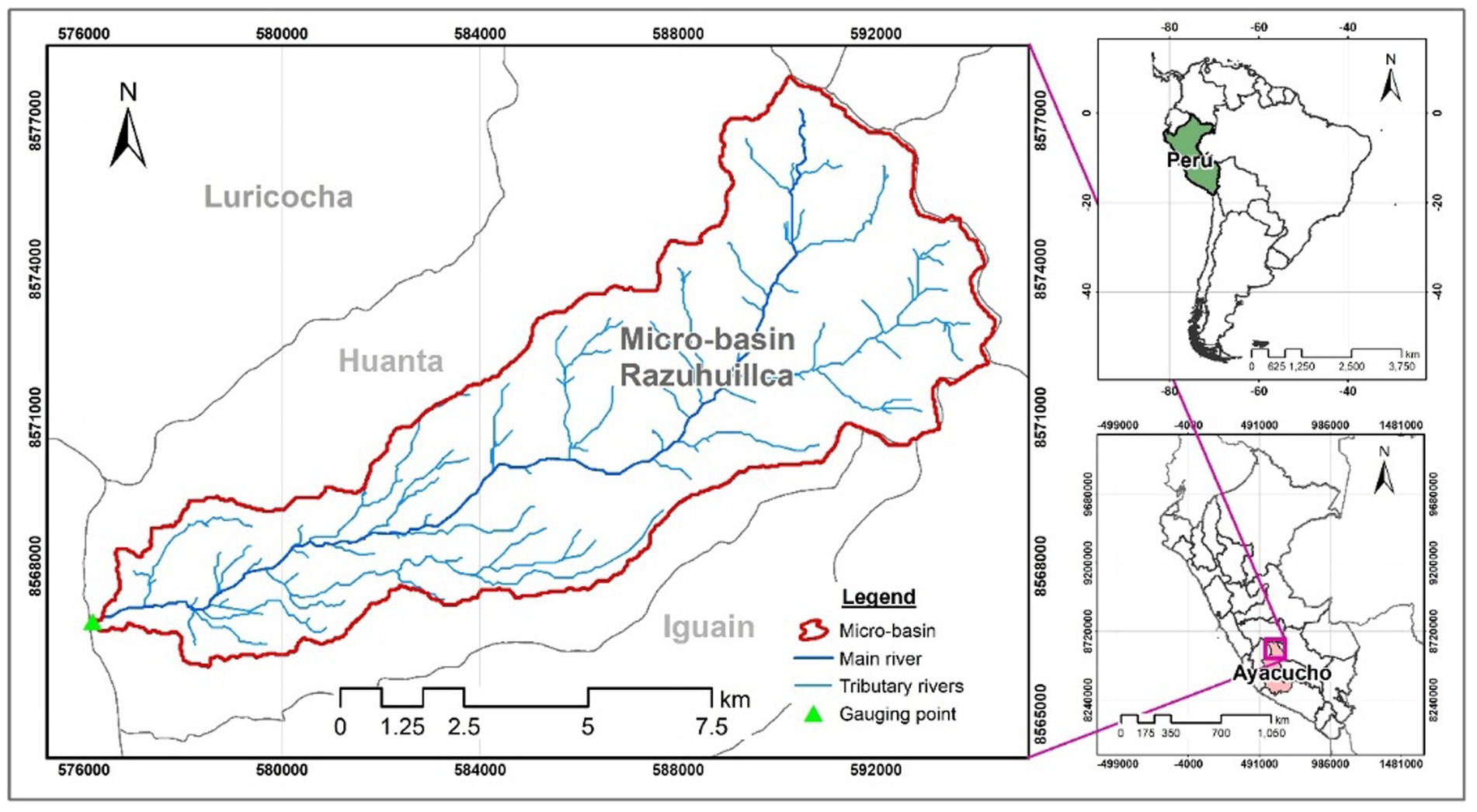
Figure 1. Location map of the Razuhuillca micro-watershed, showing its delimitation, drainage network, and geographic position within the regional context of Ayacucho.
This hydrological unit is part of the high Andean ecosystem and has an altitudinal gradient from 4,873 m.a.s.l. in the upper zone to 2,579 m.a.s.l. in the lower zone, based on a 30 m resolution Digital Elevation Model (DEM). This topographic variation shapes a differentiated hydrological dynamic, with rapid runoff in upper zones, sediment accumulation in middle zones, and greater infiltration in the lower zones.
Field observations (Supplementary Figure S2) confirmed steep slopes, active erosive processes, and low vegetation cover in critical areas, particularly in the middle-upper section. These visits also allowed the georeferencing of key features such as springs, mine adits, and water conflict zones, which were incorporated into the subsequent methodological stages.
Finally, the micro-watershed holds not only ecosystemic but also cultural and political value, being considered by local communities as a sacred territory associated with Apu Razuhuillca. This territorial dimension is key to understanding water-related conflicts in the region, particularly in light of the expansion of mining concessions.
In this study, the term “sub-watershed” refers to the six hydrological units delineated using GIS analysis from the DEM (Q1–Q6), corresponding to functional sections of the Razuhuillca micro-watershed. Since these units are locally identified as “quebradas” (ravines), the term is used interchangeably in certain sections—particularly in community narratives and qualitative analyses—to maintain technical accuracy while respecting local territorial and symbolic references.
3.1.1 Overview of datasets and fieldwork
To support the mixed-methods analysis, a range of quantitative and qualitative data sources were employed. Table 1 summarizes all datasets used in the study, including geospatial layers, satellite imagery, field documentation, and community-level qualitative inputs. The digital elevation model (DEM) served as the foundational layer for morphometric analysis and hydrological modeling, while vector datasets such as drainage networks and mining concessions were used to assess spatial overlaps with areas of community concern.
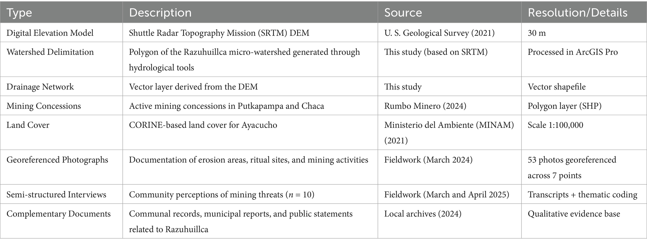
Table 1. Overview of datasets and qualitative inputs used in the study.
Qualitative data, including ten semi-structured interviews and supporting communal records, were used to capture local perceptions of environmental change and mining-related threats. The profile of the interviewees is presented in Table 2, highlighting their roles, territorial references, participation in water defense, and ethical considerations. All data were spatially referenced and integrated within a GIS environment (ArcGIS Pro 3.1), enabling cross-validation between morphometric parameters and thematic interview coding.
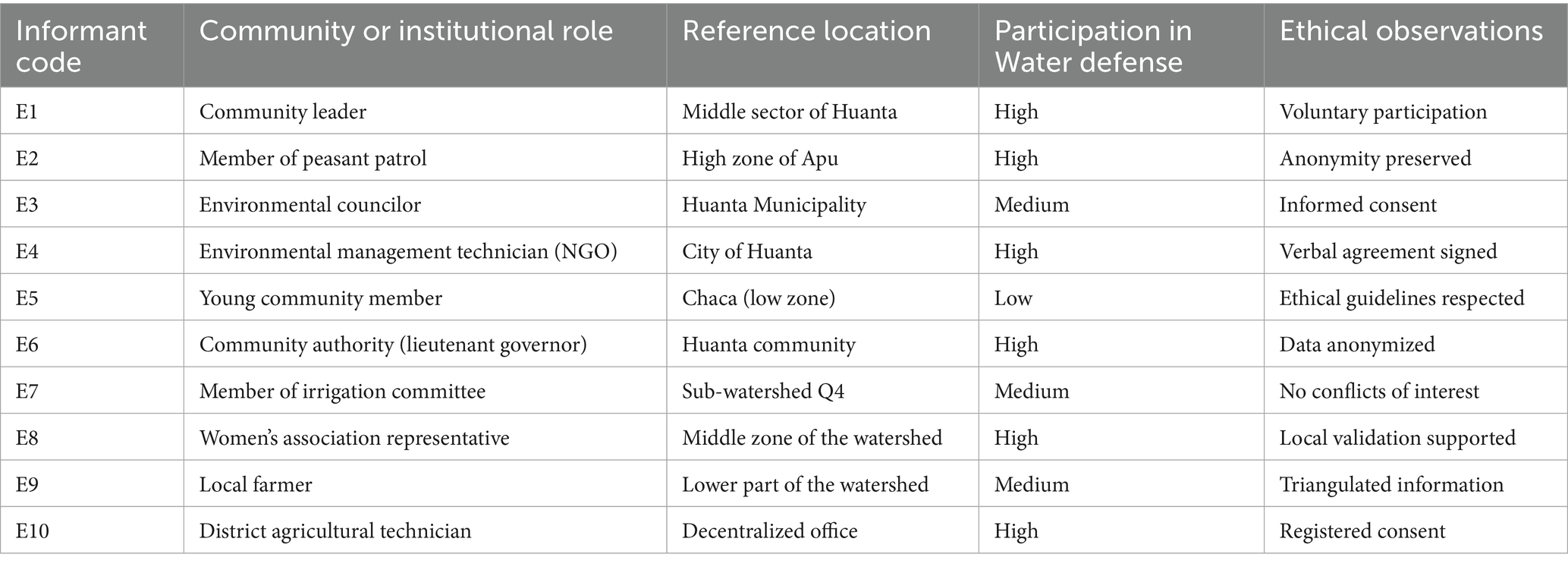
Table 2. General profile of informants interviewed in the Razuhuillca micro-watershed (n = 10).
3.2 Research design and mixed approach justification
This study follows a sequential complementary mixed-methods design, integrating quantitative morphometric analysis with qualitative inquiry to understand how the physical configuration of the Razuhuillca micro-watershed intersects with socio-environmental conflict dynamics. The approach is grounded in the paradigm of sociohydrology, which frames watersheds as hybrid systems shaped by the interplay of hydrological features and sociopolitical processes (Boelens et al., 2014; Pahl-Wostl, 2009).
The quantitative phase focused on characterizing the watershed’s structure—e.g., slope, drainage, and sub-basin configuration—using DEM-derived indices. These spatial patterns were not analyzed for hydrological modeling per se, but rather to inform the territorial reading of mining expansion, community mobilization zones, and perceived vulnerability.
The qualitative phase involved ten semi-structured interviews, coded using ATLAS.ti to extract perceptions about water meanings, mining threats, and community resistance. This component was shaped by the spatial findings of the morphometric analysis, enabling targeted inquiry. Convergence occurred in the discussion, where geospatial and narrative data were jointly interpreted to explain how Razuhuillca has become a site of conflict, memory, and resistance (Figure 2).
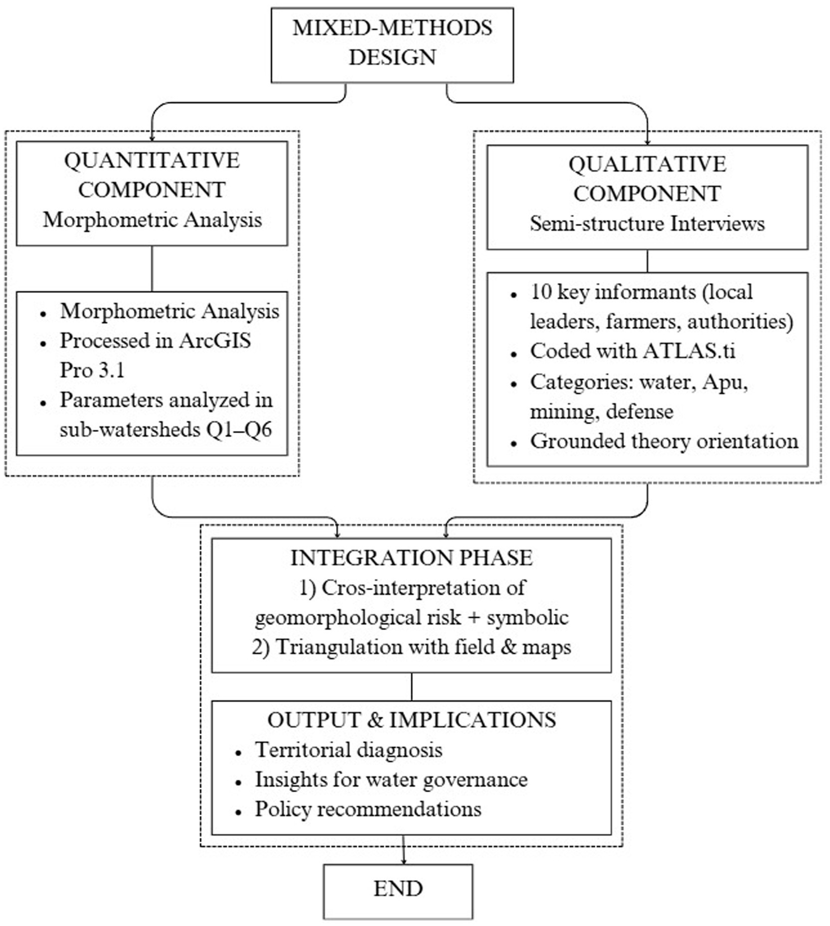
Figure 2. Conceptual flowchart of the mixed-methods research design integrating morphometric analysis and qualitative inquiry in the Razuhuillca micro-watershed.
3.3 Quantitative component: morphometric analysis
The morphometric characterization of the Razuhuillca micro-watershed was conducted to identify territorial patterns relevant to governance and extractive pressure. A 30-meter resolution Digital Elevation Model (DEM) from the USGS was processed using hydrological tools in ArcGIS, applying quality control steps to ensure topographic continuity.
Following flow direction, accumulation, and stream order analysis, the watershed was segmented into six sub-watersheds (Q1–Q6) based on both physical and socio-territorial criteria—such as the proximity to mining concessions or zones of organized community presence.
Key morphometric parameters were computed and categorized into shape, relief, and drainage metrics (Horton, 1945; Strahler, 1957). These include form factor, elongation ratio, slope, drainage density, bifurcation ratio, and torrentiality coefficient. Full values are available in Supplementary Tables S1–S9.
Importantly, these indices were not interpreted solely through a hydrological lens, but as indicators of territorial exposure. Drainage fragmentation, steep slopes, and terrain compactness define areas more difficult to monitor, access, or defend—especially under the threat of extractive expansion in upstream headwaters. These upper sub-watersheds (Q1 and Q2) exhibit a critical overlap between geomorphological vulnerability and the presence of titled or pending mining concessions. Meanwhile, lower areas (Q5 and Q6) accumulate the erosive effects of upstream interventions and show torrential patterns that may amplify downstream risks. Thus, morphometric analysis in this study serves as a diagnostic tool for identifying areas where biophysical configuration intersects with governance challenges and socio-environmental resistance.
3.4 Qualitative component: interviews and perception analysis
The qualitative component aimed to explore community perceptions and territorial meanings associated with water and mining-related pressures in the Razuhuillca micro-watershed. To this end, ten semi-structured interviews were conducted with key stakeholders—including communal leaders, irrigation committee members, NGO technicians, and representatives of grassroots organizations—selected through purposive and theoretical sampling. This approach prioritized epistemic diversity and relevance to ongoing water governance processes.
Particular attention was given to capturing the dynamics between these actors, including points of convergence and tension in their approaches to water governance. For instance, the interactions between irrigation committees and communal assemblies often revealed differing priorities, while NGO representatives occasionally acted as mediators or facilitators in community-state dialogues. These interrelations, although not always explicitly stated by participants, were inferred through triangulated analysis and cross-referenced narratives during coding.
Interviews were conducted between March and April 2025 in Quechua or Spanish, depending on participant preference. All interviews were audio-recorded with informed consent, transcribed verbatim, and anonymized to protect participant identity. The resulting transcripts were analyzed using ATLAS.ti 23, following an inductive open coding strategy rooted in grounded theory principles.
The coding process involved iterative reading and categorization of segments based on emergent themes. An initial codebook was constructed and refined through analytical triangulation and peer review, involving two external researchers. This ensured consistency, validity, and transparency in the interpretation of qualitative data.
The emergent codes were grouped into six theoretical categories that captured the socio-political dimensions of water governance in the Razuhuillca micro-watershed. These categories were not predefined, but inductively generated during the iterative coding process. Theoretical saturation was achieved through constant comparison and conceptual refinement. Each category later informed the structure and content of the qualitative results, acting as analytical lenses to interpret how territoriality, institutional distrust, and cultural meanings of water shape socio-environmental conflicts.
Supplementary Table S11 presents the anonymized profile of the interviewees along with examples of the coding process. The output of this component serves as the basis for the analytical categories developed in the results section, where the symbolic, political, and ecological narratives surrounding water and territory are more deeply examined.
A network visualization of the post-coding structure—developed using ATLAS.ti—is presented in Supplementary Figure S3, illustrating the connections between key categories such as territorial resistance, institutional distrust, and hydrosocial meanings.
3.4.1 Socioterritorial context of the communities
The rural communities associated with the Razuhuillca micro-watershed—such as Corpacancha, Chaca, and adjacent highland sectors of Huanta—exhibit a socioterritorial configuration rooted in ancestral ties, communal organization, and structural vulnerability. These are predominantly Quechua-speaking populations whose relationship with the territory is both spiritual and functional, centered on Apu Razuhuillca as a sacred mountain that protects and provides water.
Local economies are based primarily on subsistence agriculture, communal trout farming systems, and high-altitude pastoralism, with practices adapted to altitudinal zones and seasonal cycles. In the upper zone (Corpacancha), ritual activities are intertwined with communal patrols, while in Chaca, conflicts over water access and mining pressure are more prominent. Campesino patrols (rondas), irrigation committees, and lieutenant governors play key roles in local governance, serving as intermediaries between the community, the state, and external actors.
These communities—mapped in Figure 3—include over twenty discrete population centers distributed across low, middle, and high zones, each with distinct exposure to environmental threats and extractive interests. While the middle zone has emerged as a buffer territory with increasing organizational coordination, high-altitude communities are key actors in collective resistance efforts. Despite their diversity, these communities share a historical memory of marginalization and violence, particularly during the internal armed conflict that severely affected the Ayacucho region in the 1980s–1990s. This legacy of trauma and distrust continues to influence how communities engage with the State, often reinforcing their claims for prior consultation under ILO Convention 169 and their defense of water as a cultural and territorial right.
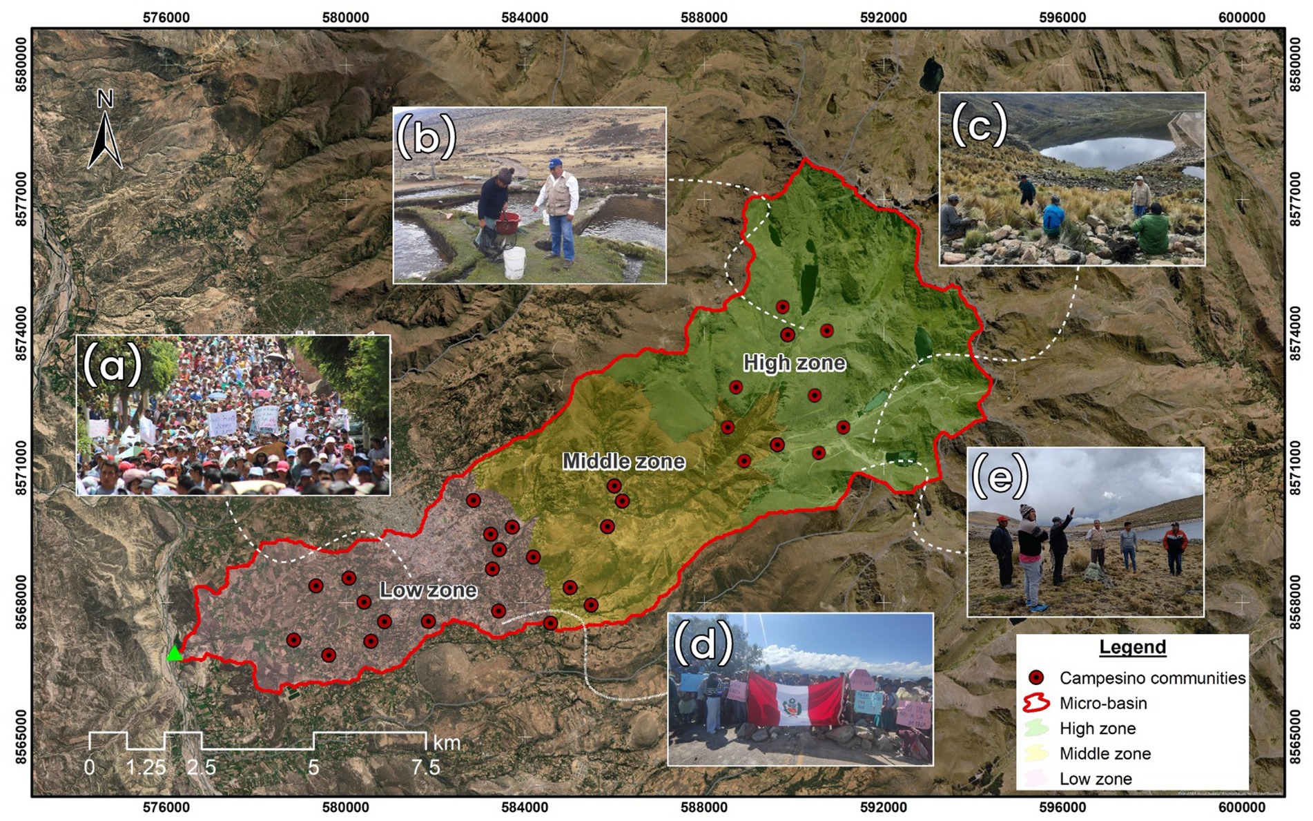
Figure 3. Socioterritorial configuration of communities in the Razuhuillca micro-watershed, segmented by altitudinal zones. The map displays campesino communities (red dots) and communal territories within the micro-basin. (a) Protest in Huanta against mining concessions. (b) Communal trout farming system in upper areas. (c) High-altitude lagoon visited during fieldwork. (d) Territorial defense demonstration with national symbols. (e) Ritual guidance near sacred Apu Razuhuillca.
Zoning follows morphometric gradients: low (pink), middle (yellow), and high (green) sectors.
3.5 Altitudinal classification and comparative analysis by sub-watersheds
To capture the internal variability of the Razuhuillca micro-watershed, an altitudinal classification was carried out into three zones—high, middle, and low—based on contour line analysis generated from the corrected DEM. This segmentation allowed for the identification of key geomorphological contrasts that influence runoff, sediment transport, and the system’s water regulation capacity.
In parallel, six main sub-watersheds (Q1–Q6) were delineated using ArcGIS Pro 3.1 hydrological tools, considering technical criteria such as stream hierarchy, drainage density, and hydrological connectivity, as well as socio-territorial criteria based on their importance for potable water supply and the presence of socio-environmental conflicts documented in the field and secondary sources.
These units were grouped according to their altitudinal location to facilitate the comparative morphometric analysis, the results of which are presented in Supplementary Tables S5–S9. Parameters analyzed include area, perimeter, shape factors, mean slope, drainage density, flow frequency, time of concentration, and torrentiality coefficient.
This multiscale segmentation was complemented by direct field observations conducted during the 2023–2024 campaigns, which allowed for the validation of differences in vegetation cover, presence of active erosion, road access, and evidence of informal extractive pressure.
Taken together, this methodology provides a robust foundation for identifying critical zones within the micro-watershed, both from a geomorphological perspective and in terms of territorial vulnerability to anthropogenic interventions.
3.6 Cartographic compilation and validation of mining concessions
In order to territorially contextualize the socio-environmental conflicts linked to the Razuhuillca micro-watershed, a thematic map was created showing the current and pending mining concessions in the districts of Huanta and Chaca (see Figure 4). This information was obtained from the official portal of the Geological, Mining, and Metallurgical Institute of Peru (INGEMMET) and validated using data from the Ministry of Energy and Mines.
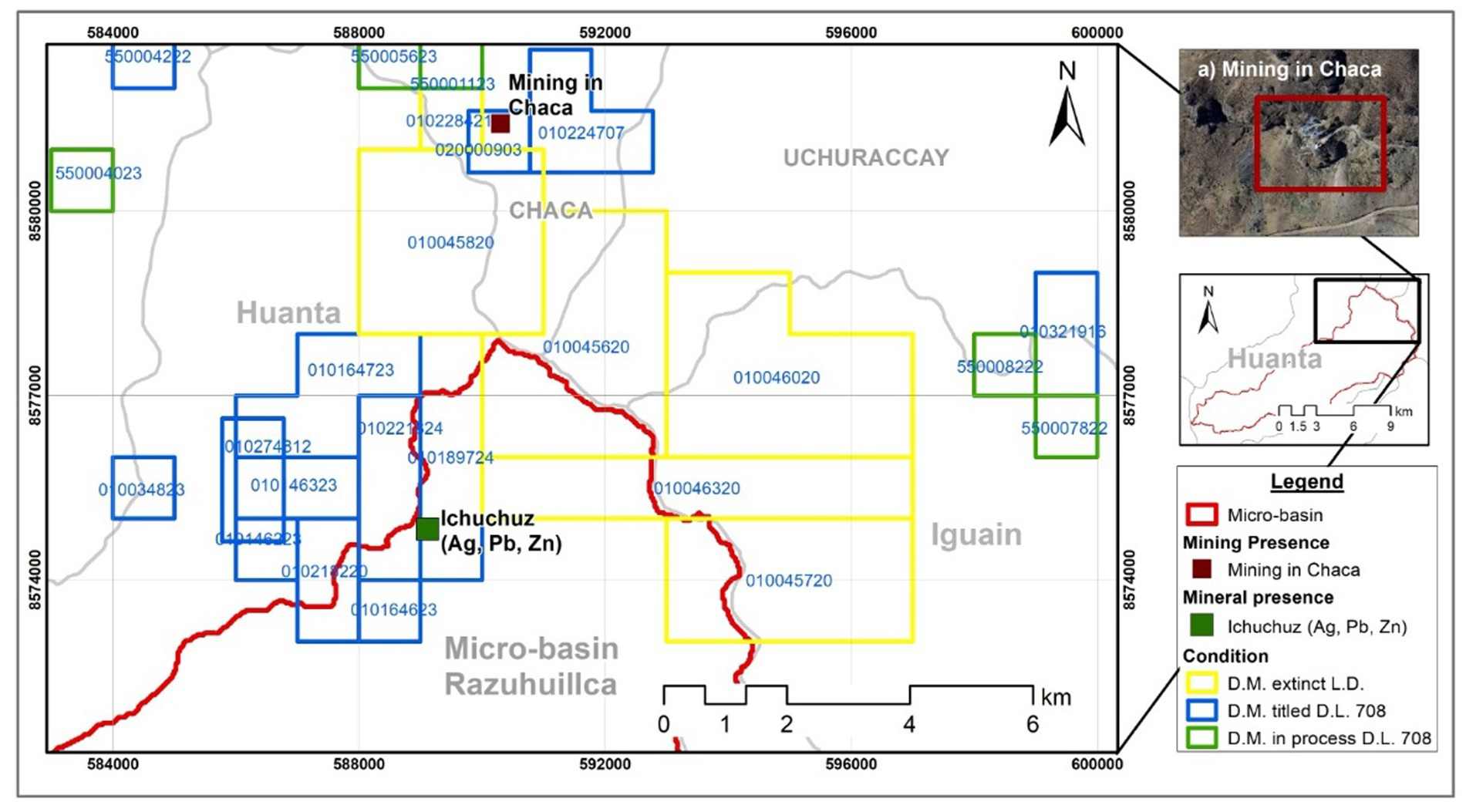
Figure 4. Spatial distribution of mining concessions within the Razuhuillca micro-watershed (2024). Overlap with Q1 and Q2 recharge zones is highlighted, along with mineral presence in Ichuchuz and field-verified activity in Chaca (a).
The spatial data were downloaded in shapefile format (.shp) and processed in ArcGIS Pro 3.1. Filters were applied based on concession name, holder, legal status (active, in process, abandoned), type of activity (exploration, exploitation, prospecting), and overlap with strategic ecosystems such as wetlands, lagoons, and headwaters. This methodology enabled the identification of critical areas where extractive pressure coincides with fragile water recharge zones.
Additionally, fieldwork was conducted between 2023 and 2024 to georeference key points of anthropogenic pressure (mine entrances, access roads, deforested areas), which were compared with concession polygons. This spatial verification also guided the selection of informants for the semi-structured interviews, ensuring the inclusion of local actors with direct links to the affected territory.
The generated map—presented in the results section—provides visual evidence of the tensions between the state concession regime and ancestral territorial water uses. This output reinforces the adopted socio-hydrological approach, supporting the call for the headwaters of the micro-watershed to be declared an intangible zone.
4 Results and discussions
4.1 Emergent categories from the qualitative analysis
The qualitative component of this study, based on ten semi-structured interviews conducted in 2025, yielded six emergent categories that synthesize how local actors perceive, inhabit, and defend the Razuhuillca micro-watershed. These categories reflect recurring thematic patterns identified during the coding process and provide insight into the socio-environmental meanings attributed to water, landscape, and extractive threats in the study area.
The interviewees include comuneros and comuneras from communities associated with the Razuhuillca territory and the city of Huanta, such as farmers, livestock herders, and local leaders engaged in environmental protection and water governance. Most participants identify as Quechua speakers and maintain ancestral links with the highland landscape through ritual and productive practices.
Each category is grounded in recurrent discursive elements and was registered according to its frequency across participants. The findings offer a descriptive snapshot of community-level territorial knowledge and the values attached to hydrosocial dynamics, sacred geography, and institutional engagement. Notably, multiple and sometimes conflicting views on water emerged across the interviews, revealing a polysemic understanding of water: some referred to it as a “protector and mother,” while others emphasized its “scarcity and risk of contamination.” This diversity of meanings has implications for local conflict, as different conceptions of water influence how communities interpret threats and defend their territory (see Table 3).
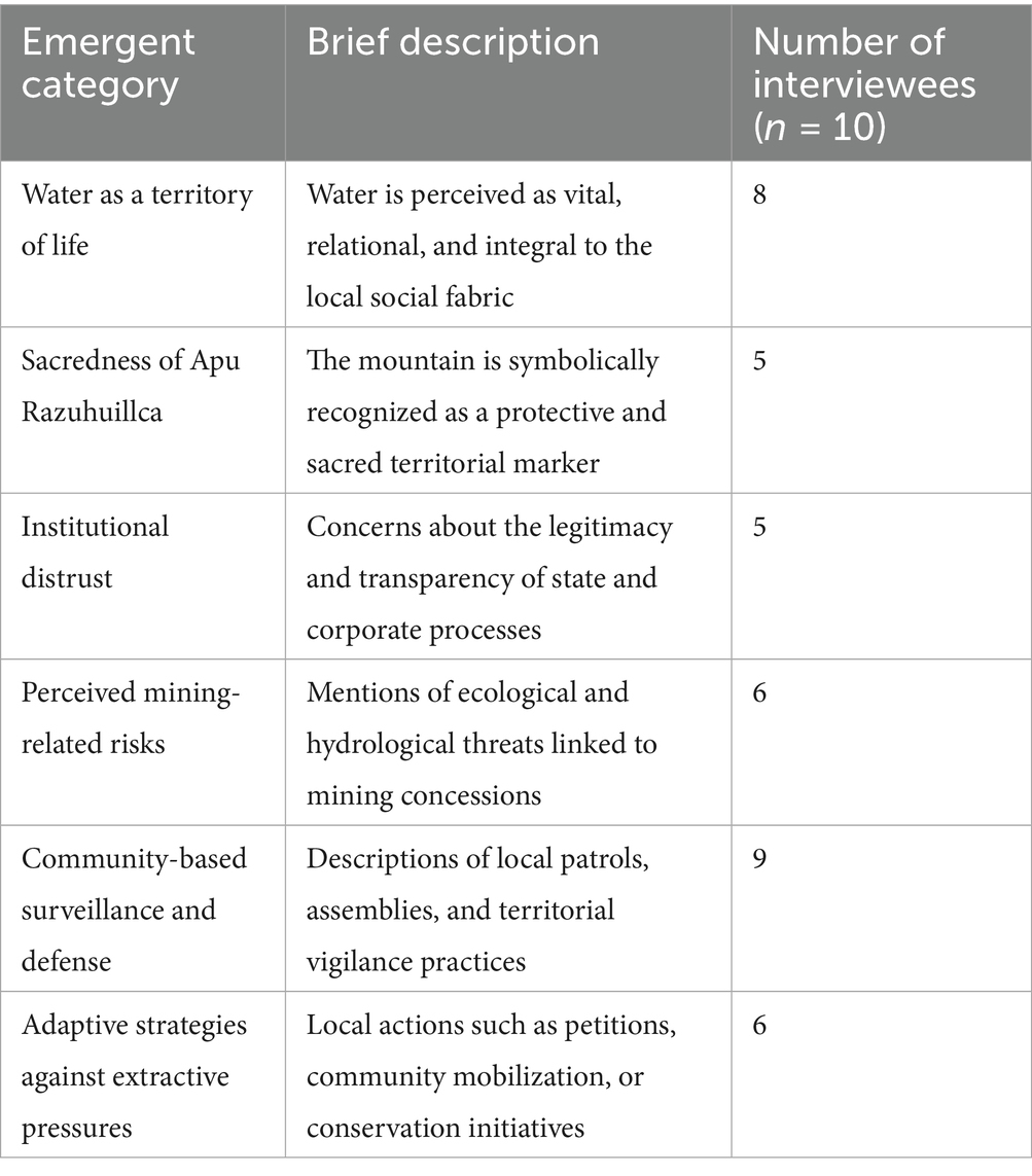
Table 3. Emergent categories derived from qualitative coding of semi-structured interviews conducted in the Razuhuillca micro-watershed (n = 10).
4.2 Geomorphological structure and physical vulnerability of the territory
The Razuhuillca micro-watershed exhibits an elongated morphology (form factor Kf = 0.32; compactness coefficient Kc = 2.16; circularity index Ic = 0.21), consistent with a narrow and extended basin structure. This configuration affects both hydrological behavior and territorial accessibility. Its elongated form limits lateral access, which—according to community testimonies—facilitates unregulated entry by extractive actors and hinders institutional presence. As one interviewee noted: “To protect the water, you must climb, observe the spring, clean it. You cannot protect it from Lima” (E2), illustrating how physical remoteness shapes governance capacity.
The watershed’s drainage network is moderately developed (Dd = 1.56 km/km2; Fd = 5.7), with a maximum stream order of 4 and a bifurcation ratio (Rb) of 4.52. These values suggest an active but fragmented fluvial system, especially in the upper sectors. The high torrentiality coefficient (Ct = 2.99) indicates rapid runoff potential in response to precipitation events. Field validation (Supplementary Figure S2) confirms visible erosion and scarce vegetation in the middle-upper zones. Residents corroborated these patterns, stating: “There are mining pits uphill, where we used to graze. Now even the water does not flow like before” (E5), linking morphological degradation with extractive disruption.
The terrain is steep and rugged, with an average slope of 8.61%, and upper sectors exceeding 24%, reaching up to 75% in certain segments (Supplementary Table S7). These areas were described by participants as both “difficult to reach” and “easier for outsiders to take over without warning” (E9). The mountainous classification (Km = 45.17) further highlights the physical isolation of these headwater areas. Such geomorphological traits act as both physical barriers and strategic vulnerabilities: they shield sacred territories like the Apu Razuhuillca but also expose them to unauthorized exploitation.
Thus, morphometric indicators in this context are not neutral descriptors—they signal socio-environmental risk. The overlap of steep slopes, torrential dynamics, and limited accessibility in upstream sub-watersheds (Q1 and Q2) correlates with sites of mining concession interest (Figure 4) and aligns with community surveillance zones (E1, E2, E9). In contrast, lower zones (Q4–Q6) exhibit gentler slopes, higher infiltration, and greater hydrological stability, serving as buffers. The physical geography of Razuhuillca therefore reinforces not only its ecological functions, but also its status as a disputed and strategically defended hydrosocial territory.
See Figure 5 for spatial segmentation of the micro-watershed and Supplementary Tables S6–S8 for detailed morphometric metrics.
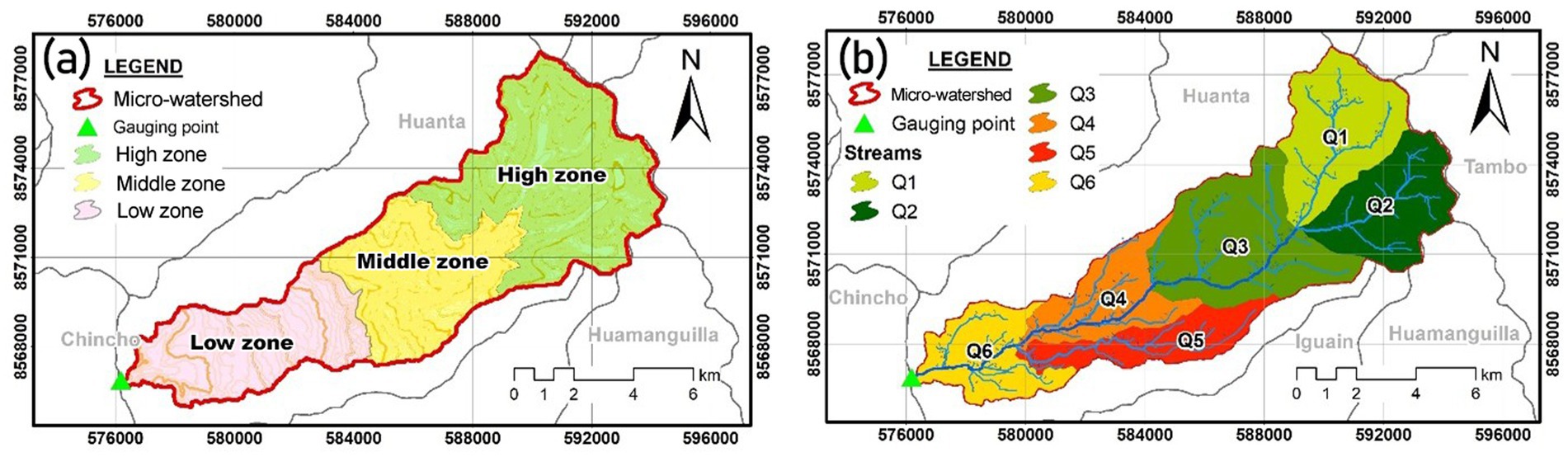
Figure 5. Altitudinal segmentation and subdivision of the Razuhuillca micro-watershed. (a) SHOWS the classification into high, middle, and low zones based on elevation gradients; (b) displays the six main sub-watersheds (Q1–Q6) derived from the DEM and hydrological analysis.
4.3 Altitudinal contrasts and erosivity patterns
The Razuhuillca micro-watershed presents distinct altitudinal zones—high (Q1–Q2), middle (Q3), and low (Q4–Q6)—whose morphometric characteristics condition erosive dynamics and territorial vulnerability (Figure 5). The comparative analysis of these sub-watersheds reveals patterns not only of runoff and sediment transfer but also of socio-environmental exposure.
In the high zone, Q1 and Q2 register the steepest slopes (17.3 and 15.9%), highest drainage densities (>1.8 km/km2), and torrentiality coefficients of 3.97 and 3.83. These metrics suggest rapid surface flow, reduced infiltration, and strong erosive potential, especially under heavy rainfall. The short concentration times (<2.5 h) and elevated bifurcation ratios (Rb > 4.7) support the diagnosis of hydrological reactivity. These areas also exhibit sigmoidal hypsometric curves, indicating terrain in dynamic equilibrium, where slope steepness and soil instability increase susceptibility to surface degradation (Rai et al., 2017).
These physical traits align with the perception of the headwaters as both sacred and threatened zones. Interviewees describe them as “where the mountain bleeds when they cut it” (E1) and report visible impacts from informal extractive activities. The combination of rapid hydrological response and limited state presence makes Q1 and Q2 critical not only in environmental terms, but as frontline areas in the community’s territorial defense.
The middle zone (Q3) represents a morphometric transition: moderate slope (10.2%), drainage density (1.56 km/km2), and torrentiality (2.48). Its convex hypsometric profile suggests geomorphological stabilization, with enhanced sediment retention and infiltration potential. Field observations confirm denser vegetation and reduced erosive markers compared to upstream sectors. This zone is often cited by interviewees as a “protective belt” between the contested upper slopes and more populated downstream areas (E9).
In the lower zone (Q4–Q6), the terrain softens (5.4–7.2% slopes), drainage density decreases (<1.5 km/km2), and torrentiality falls to 2.03–2.35. Concentration times extend (>4.2 h), indicating attenuated runoff and higher retention. The presence of alluvial terraces and consolidated soils contributes to lower erosive energy. These morphometric features match local knowledge that describes the lower watershed as a “receptive belly” that slows and nourishes water flow (E5).
Overall, the altitudinal gradient reflects a hydrosocial stratification: physical traits shape, but are also interpreted through, community experiences of risk, memory, and action. As such, Q1–Q2 emerge not only as geomorphologically unstable but also as politically exposed zones. The combination of steep slopes, extractive encroachment, and institutional absence underscores the importance of recognizing these headwaters as territories of ecological and cultural urgency.
See Figure 5 for altitudinal and sub-watershed segmentation, and Supplementary Tables S5–S9 for morphometric values.
4.4 Geomorphological evolution and altitudinal distribution
To understand the spatial heterogeneity in terrain development within the Razuhuillca micro-watershed, we integrated hypsometric curve analysis, altitudinal frequency distributions, and drainage morphometrics across its six sub-watersheds (Q1–Q6). This approach allowed for a classification of morphodynamic stages, an estimation of sediment retention capacity, and a delineation of terrain stability gradients.
The hypsometric analysis revealed three general morphotypes:
• Convex curves in Q2 and Q3, associated with more advanced geomorphological development. These units show sediment accumulation, reduced fluvial energy, and greater landscape stability—traits indicative of lower susceptibility to abrupt morphological change.
• Sigmoidal curves in Q1, Q4, Q5, and Q6, typical of mature terrain in dynamic equilibrium between erosion and deposition (Rai et al., 2017; Pande and Moharir, 2017).
• Transitional morphology in Q3 suggests a shift toward greater stabilization, with increased vegetation cover and gentler slopes.
The altitudinal frequency polygons (Supplementary Figure S6) confirmed marked elevation contrasts:
• High-altitude sub-watersheds (Q1 and Q2) presented steep gradients and peak clustering, indicating high runoff potential and limited retention capacity—key vulnerabilities in the context of upstream extractive pressure.
• Q3, located in the middle zone, showed a more uniform elevation profile, reinforcing its transitional role within the system. Lower sub-watersheds (Q4–Q6) exhibited smoother altitudinal accumulation and presence of alluvial forms, which contribute to infiltration and partial retention of sediment and runoff.
• Q4–Q6, in lower zones, exhibited smoother altitudinal accumulation and the presence of alluvial forms, which support infiltration and gradual flow dispersion.
From a drainage perspective, the watershed exhibits a moderately hierarchical fluvial system (Strahler order 4), with an average drainage density of 1.56 km/km2 (Strahler, 1957). Q1 and Q2 stand out with denser networks (>1.8 km/km2), steeper slopes, and greater branching, while Q3 retains intermediate morphometric values. Sub-watersheds Q4–Q6 demonstrate more attenuated drainage patterns consistent with lower energy regimes.
These geomorphological contrasts reveal a non-homogeneous terrain evolution, emphasizing the need for spatially differentiated strategies. Headwater units (Q1–Q2) are more susceptible to external pressures and hydromorphological shifts, while mid-and lower zones provide stabilizing functions through enhanced retention and structural maturity.
See Supplementary Figures S4, S5 for hypsometric curves and altitudinal distribution graphs.
4.5 Spatial overlap of mining concessions in headwater areas
To assess the territorial vulnerability of the Razuhuillca micro-watershed, we performed a spatial overlay of mining concessions (as of 2024) with key hydrographic and topographic features. Using INGEMMET’s Geocatmin portal and a Digital Elevation Model (DEM), our geospatial analysis revealed a striking overlap between titled or pending concessions and the headwater sub-watersheds Q1 and Q2 (Figure 4).
These upper zones are critical for groundwater recharge and ecological regulation, yet increasingly exposed to extractive interest—especially in Ichuchuz (Ag, Pb, Zn deposits) and the upper slopes of the Chaca community. Field observations and satellite imagery confirmed mining-related land use changes and incipient activity in Chaca. Notably, these extractive activities are not driven by large formal companies but by local informal miners, many of whom are residents of Chaca itself, thus generating intra-community tensions.
Although this area is inhabited by Quechua-speaking peasant communities with collective land rights, no formal process of free, prior, and informed consultation (as required by ILO Convention 169 and national law) has been carried out. Interviewees did not explicitly refer to this process, which suggests either its absence or a lack of recognition as such. This omission reinforces perceptions of institutional abandonment and weak governance in territories of indigenous identity.
The physical fragility of Q1 and Q2—marked by steep slopes (>24%), high torrentiality, and fragmented drainage—amplifies the hydro-territorial risks of extractive activities. As noted by participants, institutional presence is minimal, while extractive actors have taken advantage of topographic isolation. These conditions mirror other highland territories where physical vulnerability and institutional neglect converge to fuel socio-environmental conflict (Ginesta et al., 2022).
The actors involved in the territorial dispute include not only communal authorities and local water users (for irrigation and human consumption), but also informal miners from within the same communities and provincial-level protesters. Residents of Huanta launched indefinite strikes demanding the cancellation of mining concessions and greater protection for headwater territories. Despite this escalation, the local government’s stance has remained largely ambiguous, failing to mediate or clarify its position in official terms.
Thus, the observed spatial overlap is not merely cartographic—it reveals a multi-layered governance crisis: extractive pressure in physically vulnerable zones, fragmented community cohesion, and institutional opacity. These findings underscore the urgent need for participatory hydrosocial governance, stronger legal safeguards, and recognition of the territorial rights of indigenous communities.
See Figure 4 for mapped concessions and overlap with Q1–Q2 recharge zones. Detailed codes and legal statuses are listed in Supplementary Table S10.
5 Summary discussion
5.1 Hydro-territorial risk and extractive pressure in headwater zones
The spatial overlap between mining concessions and the headwaters of the Razuhuillca micro-watershed represents a direct threat to the hydrological functionality and geomorphological balance of the territory. Geospatial analysis showed that streams such as Q1 and Q2, located in high-altitude zones that are strategic for water recharge, exhibit alarming coincidences with active concession polygons (Figure 4).
This situation is exacerbated by the physical characteristics already identified in these sub-watersheds: slopes greater than 24%, active erosion processes, and low vegetation cover. Extractive intervention in such terrains can intensify slope instability, alter runoff flows, and jeopardize downstream water availability (Ginesta et al., 2022).
Field validations, along with perceptions gathered during interviews, reveal widespread concern about the lack of prior consultation, the imprecise delineation of mining polygons, and the absence of proper environmental assessments. This institutional distrust reinforces a perception of territorial vulnerability and fuels a narrative of water defense in the face of extractive imposition (Budds and Hinojosa, 2012; Boelens et al., 2018).
From a socio-hydrological perspective, the convergence of physical fragility and mining pressure in headwater zones highlights a critical point for water management and territorial justice. In contexts like Huanta, such overlap not only represents an environmental risk but also intensifies social tensions and disputes over the territorial and cultural rights of local communities.
5.2 Perceptions, affective territories, and disputes over water governance
The Razuhuillca micro-watershed is not merely a hydrological or geomorphological unit—it is perceived by local communities as a living and affective territory. Interviewees refer to water as “the blood of the mountain” (E1), and invoke the Apu Razuhuillca as a sacred entity whose protection transcends institutional boundaries. This worldview articulates a hydrosocial understanding of territory, in which water is not only a biophysical resource but also a cultural, ethical, and emotional anchor (Boelens et al., 2014; Escobar, 2016).
This aligns with the concept of affective territorialities, where relationships to land and water are shaped by emotional and symbolic ties, grounded in kinship, reciprocity, and ancestral continuity. As argue, these forms of attachment constitute alternative governance frameworks—rooted in care, memory, and relational values—that resist the mercantilization of nature as a mere economic asset.
Community discourses reveal a deep epistemic divergence with institutional logics. Development, often equated by the state with mining investment, is redefined by local actors as “the continuity of life with water” (E3). This re-signification transforms water into a political and symbolic frontier where opposing worldviews clash: one centered on extractive expansion, the other on ecological and cultural reproduction (Boelens et al., 2018; Gutiérrez Gómez and Aronés Cisneros, 2022). Community members reinforce this vision through tangible actions—such as the photographic documentation of erosion zones, ritual spaces, and extractive activity—which serve as both evidence and resistance.
These tensions manifest not only in discourse but also in territorial practices of resistance. Communal patrols, minutes of assembly, and grassroots monitoring systems are enacted to protect springs, report incursions, and demand accountability—especially in headwater zones threatened by extractive interests. Such initiatives reflect bottom-up territoriality, whereby local forms of governance emerge autonomously in the absence—or complicity—of the state (Rodríguez-de-Francisco and Boelens, 2016; Pahl-Wostl, 2009).
Affective ties thus become political tools. Recent research in contexts of water commodification, such as rural Chile, shows how community governance is sustained through social capital and the patrimonialization of water as a collective heritage (Boso, 2023). In Razuhuillca, similar dynamics unfold: water is not managed as an isolated good, but as a relational right deeply embedded in histories of struggle, identity, and territory.
Furthermore, the testimonies make evident the polysemic nature of water in Razuhuillca. For E1 and E7, water is not just a vital element—it is “the blood of the mountain” and a spiritual force guarded by the Apu. For E2 and E9, it becomes a symbol of struggle, identity, and communal defense. These meanings transcend functional or emotional relationships, pointing to a sacred and political ontology of water. As Urteaga (2009) and Boelens et al. (2014) have argued, Andean communities often attribute multiple layers of meaning to water—as life, ancestor, and territory—thus challenging reductive approaches to water governance. Recognizing this polysemy is key to understanding why hydrological interventions provoke not just ecological concern, but also moral outrage and territorial mobilization.
5.3 Disputed territorialities: perceptions, water defense, and socio-environmental conflict
The convergence of mining concessions and water recharge zones in the Razuhuillca micro-watershed represents both a biophysical threat and a deeply symbolic axis of territorial dispute. Spatial analysis confirmed the alarming overlap between concession polygons and headwater sub-watersheds Q1 and Q2—zones that community members, authorities, and technicians repeatedly identified as territories where rights are being violated and prior consultation systematically ignored (Defensoría del Pueblo, 2024; Bebbington et al., 2010).
From a sociohydrological perspective, this territorial conflict cannot be reduced to land-use disagreements—it reflects an epistemic struggle over the legitimacy of development models, the valuation of water, and the right to govern territory. In Latin America, such disputes have been widely documented as expressions of cultural resistance to extractive imposition (Boelens et al., 2018; Budds and Hinojosa, 2012; Ulloa and Romero-Toledo, 2018).
Thematic coding of interviews revealed six consistent categories, underlining the centrality of water not only as a resource, but as a cultural, sacred, and emotional axis. Eight of ten interviewees described water as structuring both agricultural rhythms and spiritual relations with the Apu Razuhuillca. As one respondent said: “Water is the mountain’s blood. If the mountain gets sick, so do we” (E1). This echoes the framework of hydrosocial territories, where water becomes a thread that weaves together ecology, memory, and political meaning (Boelens et al., 2014; González et al., 2024).
Institutional distrust also emerged strongly. Five participants denounced extractive impositions without meaningful consultation: “They say they will consult us, but they never come. We only see the maps with those little boxes” (E6). Such perceptions reflect not only a democratic deficit, but a deep asymmetry between state legality and community legitimacy, a gap that undermines collective governance and exacerbates conflict (Slosse et al., 2025).
Nine of ten interviewees reported autonomous surveillance and resistance practices, including community patrols, emergency assemblies, and local roundtables in response to extractive threats. However, internal tensions were also noted, particularly in Chaca, where informal mining created intra-community friction: “We did not want to fight, but we had to confront them. That water flows down to us too” (E4). These cases highlight the fragility of community cohesion under external pressures and the urgency of reinforcing solidarity for sustainable water governance (Boelens et al., 2014).
Crucially, the Apu Razuhuillca emerged as a protective territorial entity—not deified but revered through an ethic of reciprocity: “It’s not that we worship it like a god, we care for it because life springs from it” (E7). These affective geographies shape a distinct territorial rationality, one grounded not in extractive logic but in care, memory, and ancestral continuity (Escobar, 2016; Gutiérrez Gómez and Aronés Cisneros, 2022). As Sultana (2011) notes, emotion plays a critical role in shaping the experience and politics of water, mediating how access and resistance unfold.
Similar territorial dynamics have been documented in other Andean regions. In the Ramis river basin (Puno), Giraldo Malca (2020) describes how informal gold mining, institutional inaction, and territorial imposition have reconfigured landscapes and sparked intense socio-environmental conflict, mirroring the case of Razuhuillca. Likewise, Bebbington et al. (2010) detail how rural communities in Espinar and other Peruvian highlands have mobilized in defense of their livelihoods and hydrosocial territories, confronting extractive expansion through grassroots governance and identity-based resistance. These parallels reinforce the idea that Razuhuillca is not an isolated case, but part of a broader Andean pattern of contested territorialities shaped by asymmetrical governance and competing visions of water, development, and justice.
Finally, several adaptive responses emerged from the interviews—campaigns, civil society alliances, and formal petitions to protect the headwaters. These actions reflect localized agency built upon empirical territorial knowledge, memory of past grievances, and a developmental ethic centered on water rather than profit: “For them, development is money. For us, it is water” (E3). This mirrors experiences such as in Peña Blanca, Mexico, where hydrosocial identities enable territorial defense under climate pressure (González et al., 2024), and highland Peru, where intercultural environmental education fosters participatory governance and water-centered conservation (Cárdenas Morales et al., 2025).
The actors involved in the territorial dispute include not only communal authorities and local water users (for irrigation and human consumption), but also informal miners from within the same communities and provincial-level protesters. Residents of Huanta launched indefinite strikes demanding the cancellation of mining concessions and greater protection for headwater territories. Despite this escalation, the local government’s stance has remained largely ambiguous, failing to mediate or clarify its position in official terms.
These narratives reveal a polysemic conception of water, shaped by spiritual, utilitarian, and political dimensions. While some participants emphasized water’s sacred character as the lifeblood of the mountain (E1, E7), others framed it as a right and a territory under threat, inseparable from community survival and justice (E3, E6). This plurality of meanings—ranging from cultural reciprocity to resource defense—deepens the intensity of local conflicts, as extractive interests clash with ancestral ontologies and affective geographies. As noted by Boelens et al. (2014) and Sultana (2011), such hydrosocial imaginaries shape not only how water is valued, but also how resistance is articulated.
5.4 Historical memory and the roots of territorial resistance
The socio-environmental conflict in the Razuhuillca micro-watershed cannot be fully understood without acknowledging the broader historical and political context of Huanta. Known as “The Emerald of the Andes,” Huanta has long been a site of structural exclusion and grassroots mobilization. From the 1969 student and peasant rebellion against military educational reforms to the 2022 burning of the Provincial Prosecutor’s Office as a form of popular justice, and most recently, the 2024 indefinite strike against mining concessions in Razuhuillca, these episodes reflect a deep-rooted political rationality shaped by memory, identity, and territorial defense.
These mobilizations are not isolated or spontaneous, but rather part of an intergenerational repertoire of struggle. As revealed by community testimonies in this study, narratives of defense against external threats are woven into a collective memory that legitimizes current protest actions. This phenomenon aligns with the eco-territorial turn observed in other Andean regions, where water and land are defended not only as resources but as sacred and communal spaces of life, identity, and autonomy (Svampa, 2019).
Drawing on recent work by Gari Huayhua Lévano et al. (2025), radicalization in Huanta is not an anomaly, but a structural response to state violence, institutional neglect, and the imposition of extractive logics. The overlapping of mining concessions with communal territories is perceived as a continuation of historical dispossession. In this context, the Razuhuillca watershed emerges as both a strategic hydrological system and a symbolic site of resistance, where water governance intersects with legal pluralism, cultural sovereignty, and contested state legitimacy.
This legacy of resistance reinforces the polysemic value of water in the micro-watershed, as reflected in interview narratives. Water is simultaneously sacred, productive, and political. The historical dimension thus acts as a catalyst that intensifies community responses and situates Razuhuillca within a broader landscape of Andean territorial struggles.
5.5 Recommendations for socio-hydrological management
Based on the morphometric, spatial, and qualitative analysis conducted in this study, the following recommendations are proposed for the integrated management of the Razuhuillca micro-watershed:
1. Prioritize ecological restoration actions in headwater zones (Q1 and Q2) through reforestation, gully control, and vegetation cover recovery, aiming to reduce surface runoff, accelerated erosion, and soil loss in areas with high slope and torrentiality.
2. Recognize and protect water recharge areas through ecological and economic zoning (ZEE), identifying critical zones of hydrological regulation for designation as intangible or restricted-use areas in the face of extractive activities.
3. Critically review the legal frameworks for mining concessions to prevent overlaps with headwaters and communal territories, ensuring that any authorization considers hydrological, ecosystemic, and socio-territorial criteria.
4. Strengthen prior consultation processes in an effective and binding manner, guaranteeing informed and deliberative participation of affected communities, in compliance with ILO Convention 169 and national legislation.
5. Promote community co-management of water, encouraging the strengthening of local capacities for participatory monitoring, autonomous territorial surveillance, and the production of knowledge from within the communities themselves—especially in contexts of high socio-environmental conflict.
6. Incorporate principles of environmental justice and multi-level governance into public policies on high-Andean watershed management, recognizing the plurality of knowledge systems, rights, and scales of action necessary for sustainable and equitable water governance.
5.6 Study limitations
This study presents some limitations that should be considered when interpreting the results. First, the delimitation and morphometric analysis were based on a 30-meter resolution Digital Elevation Model (DEM), which may limit precision in areas with high topographic variability. Likewise, the qualitative component was based on a purposive sample of ten interviews, which, although allowing for in-depth narrative exploration, does not necessarily represent the full range of perceptions within the watershed’s communities.
Furthermore, although a cartographic and field validation of mining concessions was conducted, the study lacked access to the corresponding environmental impact assessments, limiting the direct analysis of specific impacts. This is compounded by the limited availability of systematic previous studies on the Razuhuillca micro-watershed, which hindered direct comparison with past research and required an adaptive methodological design.
Finally, the study focused on a single round of qualitative coding; future research could reinforce these findings through broader and more longitudinal participatory processes. These limitations do not undermine the validity of the findings but do indicate the need for complementary studies with greater temporal, spatial, and participatory depth.
6 Conclusion
The integrated analysis of the Razuhuillca micro-watershed revealed marked hydro-geomorphological variability conditioned by its elongated morphology, extreme altitudinal gradients, and hierarchical drainage network. These characteristics shape differential patterns of runoff, erosion, and water regulation across the upper, middle, and lower zones of the watershed.
Morphometric parameters indicated that the upper part of the watershed concentrates the highest risks of torrentiality and soil loss, whereas the lower part functions as a buffer zone and sediment accumulation area. Hypsometric curves and altitudinal frequency polygons confirmed a geomorphological evolution toward maturity, with specific exceptions indicating areas of vulnerability.
Cartographic validation exposed a critical overlap between mining concessions and headwater areas, representing a direct threat to the hydrological functionality and geomorphological balance of the system. This finding is reinforced by field testimonies, where water is perceived not merely as a resource, but as a relational and territorially sacred entity.
The methodological triangulation—combining GIS, morphometric analysis, and qualitative interviews—enabled the construction of a multiscalar and socio-hydrological understanding of the territory. This approach provides key technical and social evidence to inform water management strategies that are sensitive to the Andean context, promoting ecological restoration, community-based surveillance, and participatory governance.
In sum, the Razuhuillca micro-watershed should be recognized as a priority socio-ecosystem, where physical, ecological, and sociopolitical processes converge—demanding integrative approaches to ensure its resilience against extractive pressures and climate change.
Data availability statement
The original contributions presented in the study are included in the article/Supplementary material, further inquiries can be directed to the corresponding author.
Ethics statement
The studies involving humans were approved by Walter Castro Aponte—Universidad Nacional Autónoma de Huanta. The studies were conducted in accordance with the local legislation and institutional requirements. The participants provided their written informed consent to participate in this study.
Author contributions
BC: Data curation, Writing – review & editing, Methodology, Software, Formal analysis, Writing – original draft, Investigation, Supervision, Visualization, Funding acquisition, Validation, Resources, Conceptualization, Project administration. MM: Software, Conceptualization, Resources, Visualization, Investigation, Funding acquisition, Writing – original draft, Methodology, Validation, Writing – review & editing, Formal analysis, Project administration, Data curation, Supervision. SH: Conceptualization, Writing – original draft, Funding acquisition, Methodology, Visualization, Data curation, Formal analysis, Validation, Resources, Investigation. SC: Data curation, Resources, Conceptualization, Supervision, Funding acquisition, Project administration, Writing – review & editing, Formal analysis, Validation, Methodology. WC: Visualization, Methodology, Conceptualization, Resources, Writing – review & editing. YG: Visualization, Methodology, Conceptualization, Resources, Writing – review & editing, Funding acquisition, Software, Formal analysis. YH: Writing – review & editing, Methodology, Supervision, Funding acquisition, Visualization, Resources, Formal analysis, Validation, Conceptualization, Project administration. SO: Data curation, Investigation, Writing – review & editing, Conceptualization, Resources, Formal analysis, Visualization, Funding acquisition. JL: Formal analysis, Writing – review & editing, Validation, Data curation, Conceptualization. FH: Visualization, Validation, Project administration, Data curation, Methodology, Formal analysis, Conceptualization, Writing – original draft, Resources. TP: Writing – original draft. CB: Resources, Writing – review & editing. LL: Validation, Writing – review & editing.
Funding
The author(s) declare that financial support was received for the research and/or publication of this article. This research was supported by the Universidad Nacional Autónoma de Huanta through the Research and Training Agreement with the University of Cambridge (2023–2026, Agreement number G117323).
Acknowledgments
We express our sincere gratitude to the men and women of the Razuhuillca micro-watershed for their openness, time, and valuable collaboration throughout this research. Their deep knowledge of the territory, their voices, and their unwavering commitment to the defense of water were essential to understanding the socio-environmental complexity of the region. To the people of Huanta, for their tireless struggle for water and life, which inspires and gives meaning to every academic effort aimed at the common good. This work is especially dedicated to the members of the organizing committee — Delia Gamarra Gamarra, Juvenal Castromonte Salinas, and Jorge Isaac Castro Bedriñana — whose motivation, trust, and example inspired us to become better researchers and to pursue academic excellence with social purpose. Finally, in loving memory of Tiw, our faithful companion whose silent presence and affection brightened many long days of writing.
Conflict of interest
The authors declare that the research was conducted in the absence of any commercial or financial relationships that could be construed as a potential conflict of interest.
Generative AI statement
The author(s) declare that no Gen AI was used in the creation of this manuscript.
Publisher’s note
All claims expressed in this article are solely those of the authors and do not necessarily represent those of their affiliated organizations, or those of the publisher, the editors and the reviewers. Any product that may be evaluated in this article, or claim that may be made by its manufacturer, is not guaranteed or endorsed by the publisher.
Supplementary material
The Supplementary material for this article can be found online at: https://www.frontiersin.org/articles/10.3389/frwa.2025.1614847/full#supplementary-material
References
Arias-Muñoz, D. P., Jiménez-Illapa, R. P., and Renato, J. (2023). Reporte de salud ambiental de la cuenca hidrográfica del río Ambi, Ecuador. Available online at: https://www.researchgate.net/publication/378363937_REPORTE_DE_SALUD_AMBIENTAL_DE_LA_CUENCA_HIDROGRAFICA_DEL_RIO_AMBI-ECUADOR
Bebbington, A., Bebbington, D. H., Bury, J., Lingan, J., Muñoz, J. P., and Scurrah, M. (2010). Mining and social movements: struggles over livelihood and rural territorial development in the Andes. World Dev. 38, 223–236. doi: 10.1016/j.worlddev.2007.11.016
Boelens, R., Hoogesteger, J., and Rodríguez-de-Francisco, J. C. (2014). Commoditizing water territories: The clash between Andean water rights cultures and payment for environmental services policies. Capitalism Nature Socialism, 25, 84–102 doi: 10.1080/10455752.2013.876867
Boelens, R., Vos, J., and Perreault, T. (2018). “Introduction: the multiple challenges and layers of water justice struggles” in Water justice. eds. R. Boelens, T. Perreault, and J. Vos (chapter, Cambridge: Cambridge University Press), 1–32.
Boso, Á. (2023). Gobernanza comunitaria de sistemas de agua potable rural en un contexto altamente privatizado: reflexiones a partir de caso de estudio en La doi: 10.17561/at.23.7207
Budds, J., and Hinojosa, L. (2012). Restructuring and rescaling water governance in mining contexts: The co-production of waterscapes in Peru. Water Alternatives, 5, 119–137. Available at: https://www.wateralternatives.org/index.php/volume5/v5issue1/161-a5-1-8
Cárdenas Morales, B. K., Mendoza Colos, M., Herrera Clemente Díaz, S., and Oré Gálvez, S. F. (2025). Integrating education and conservation: a case study of the Huaper wetland. Front. Psychol. 16:1517653. doi: 10.3389/fpsyg.2025.1517653
Defensoría del Pueblo (2024). Defensoría del Pueblo demanda conformación de mesa de alto nivel liderada por el Ejecutivo ante conflicto socioambiental en Huanta”. Available at: https://www.defensoria.gob.pe/defensoria-del-pueblo-demanda-conformacion-de-mesa-de-alto-nivel-liderada-por-el-ejecutivo-ante-conflicto-socioambiental-en-huanta/
Escobar, A. (2016). Thinking-feeling with the Earth: Territorial Struggles and the Ontological Dimension of the Epistemologies of the South. Durham, NC, USA: Duke University Press.
Gari Huayhua Lévano, F., Cardenas Morales, B. K., Ñaupari Molina, R., Oré Gálvez, S. F., Quispe Quispe, A., et al. (2025). Popular justice and territorial resistance in the Peruvian Andes: the case of Huanta. Frontiers. Sociology 10:1602160. doi: 10.3389/fsoc.2025.1602160
Gaspari, F. J., Rodríguez Vagaría, A. M., Senisterra, G. E., Denegri, G. A., Besteiro, S., and Delgado, M. I. (2012). Caracterización morfométrica de la cuenca alta del río Sauce Grande, Buenos Aires Argentina Universidad Nacional de La Plata. Available online at: http://sedici.unlp.edu.ar/handle/10915/25777
Ginesta, C., Rios, N., and Esper, M. (2022). Morphometric characterization of the Talacasto River basin, central Precordillera, San Juan, Argentina. Bol. Soc. Geol. Mex. 74, 1–18. doi: 10.18268/BSGM2022v74n1a300921
Giraldo Malca, U. F. (2020). Minería informal en la cuenca alta del río Ramis: Impactos en el paisaje y evolución del conflicto socioambiental. Lima: Escuela de Posgrado, Pontificia Universidad Católica del Perú (PUCP).
González, M. A., González, C. L., and Gómez, E. (2024). Identidades hidrosociales y territorialidades emergentes en contextos de cambio climático: el caso de Peña Blanca (México). Rev. Latinoam. Estud. Ambient. 8, 32–48. doi: 10.48082/rlea.v8i1.561
Gutiérrez Gómez, E., and Aronés Cisneros, A. A. (2022). Samikuy: Ritual ancestral al Apu Razuhuillca [Samikuy: Ancestral ritual to Apu Razuhuillca]. Maracaibo, Venezuela: Revista de Filosofía, Universidad del Zulia. doi: 10.5281/zenodo.7309260
Horton, R. E. (1945). Erosional development of streams and their drainage basins: hydrophysical approach to quantitative morphology. Geol. Soc. Am. Bull. 56, 275–370. doi: 10.1130/0016-7606(1945)56[275:EDOSAT]2.0.CO;2
Jenson, S. K., and Domingue, J. O. (1988). Extracting topographic structure from digital elevation data for geographic information system analysis. Photogramm. Eng. Remote. Sens. 54, 1593–1600.
Pahl-Wostl, C. (2009). A conceptual framework for analysing adaptive capacity and multi-level learning processes in resource governance regimes. Glob. Environ. Chang. 19, 354–365. doi: 10.1016/j.gloenvcha.2009.06.001
Pande, C. B., and Moharir, K. (2017). GIS-based quantitative morphometric analysis and its consequences: a case study from Shanur River basin, Maharashtra India. Appl Water Sci 7, 861–871. doi: 10.1007/s13201-015-0298-7
Rai, P. K., Mohan, K., Mishra, S., Ahmad, A., and Mishra, V. N. (2017). A GIS-based approach in drainage morphometric analysis of Kanhar River basin, India. Appl Water Sci 7, 217–232. doi: 10.1007/s13201-014-0238-y
Rodríguez-de-Francisco, J. C., and Boelens, R. (2016). PES hydrosocial territories: de-territorialization and re-patterning of water control arenas in the Andean highlands. Water Int. 41, 140–156. doi: 10.1080/02508060.2016.1129686
Schumm, S. A. (1956). Evolution of drainage systems and slopes in badlands at Perth Amboy, New Jersey. Geol. Soc. Am. Bull. 67, 597–646. doi: 10.1130/0016-7606(1956)67[597:EODSAS]2.0.CO;2
Slosse, W., Benavides, J. P., Branisa, B., Buysse, J., D’Haese, M., Quezada Lambertín, C. E., et al. (2025). Ripples of reciprocity: navigating trust and collective governance in hydrosocial territories. World Dev. 188:106900. doi: 10.1016/j.worlddev.2024.106900
Sosa, C.Comisión en Defensa del Agua y la Vida. (2023). Los mega proyectos dejan un pasivo ambiental que pagamos nosotros. El Acontecer. Recuperado de. Available online at: https://elacontecer.com.uy/2023/08/14/carmen-sosa-de-la-comision-en-defensa-del-agua-y-la-vida-los-mega-proyectos-dejan-un-pasivo-ambiental-que-pagamos-nosotros/
Strahler, A. N. (1957). Quantitative analysis of watershed geomorphology. Trans. Am. Geophys. Union 38, 913–920. doi: 10.1029/TR038i006p00913
Sultana, F. (2011). Suffering for water, suffering from water: Emotional geographies of resource access, control and conflict. Geoforum, 42, 163–172. doi: 10.1016/j.geoforum.2010.12.002
Svampa, M. (2019). Neo-extractivism in Latin America: Socio-environmental conflicts, the territorial turn, and new political narratives. Cambridge University Press. doi: 10.1017/9781108752589
Ulloa, A., and Romero-Toledo, H. (2018). De aguas naturales a aguas politizadas: conflictos y resistencias en torno al agua en Chile y Colombia : Centro de Estudios del Conflicto y Cohesión Social (COES). Bogotá, Colombia: Universidad del Rosario.
Keywords: morphometry, Andean micro-watershed, water governance, GIS, mining concessions, socio-environmental conflict
Citation: Cárdenas Morales BK, Mendoza Colos M, Herrera Díaz SC, Carhuallanqui Ibarra SD, Castro Aponte WV, Gómez Ccochachi YY, Huari Salazar YC, Oré Gálvez SF, Lozano Rodríguez JL, Huayhua Lévano FG, Paytan Montañez TC, Barnes CHW and De Los Santos Valladares L (2025) The Razuhuillca micro-watershed in dispute: hydromorphological dynamics and territorial resistance to mining concessions in the Peruvian Andes. Front. Water. 7:1614847. doi: 10.3389/frwa.2025.1614847
Edited by:
Heidi Kreibich, GFZ German Research Centre for Geosciences, GermanyReviewed by:
Patricia Urteaga-Crovetto, Pontifical Catholic University of Peru, PeruFabio Brill, Humboldt University of Berlin, Germany
Copyright © 2025 Cárdenas Morales, Mendoza Colos, Herrera Díaz, Carhuallanqui Ibarra, Castro Aponte, Gómez Ccochachi, Huari Salazar, Oré Gálvez, Lozano Rodríguez, Huayhua Lévano, Paytan Montañez, Barnes and De Los Santos Valladares. This is an open-access article distributed under the terms of the Creative Commons Attribution License (CC BY). The use, distribution or reproduction in other forums is permitted, provided the original author(s) and the copyright owner(s) are credited and that the original publication in this journal is cited, in accordance with accepted academic practice. No use, distribution or reproduction is permitted which does not comply with these terms.
*Correspondence: Bruno Kadafi Cárdenas Morales, YmVuaXRva2luZzE1OUBnbWFpbC5jb20=; Luis De Los Santos Valladares, bGQzMDFAY2FtLmFjLnVr