 Jeff Popke1*
 Mizanur Rahman2
- 1Department of Earth, Environment and Planning, East Carolina University, Greenville, NC, United States
- 2Department of Geosciences, Florida Atlantic University, Boca Raton, FL, United States
Delta regions represent unique settings characterized by a combination of dynamic hydrological environments and livelihood opportunity. They are sites of intensive human activity and infrastructure development aimed at managing the environment and ameliorating hazards such as riverbank erosion. In this paper, we present a case study from the Meghna River delta highlighting livelihood dynamics in the context of riverbank erosion and the recent construction of a protective concrete revetment. To account for the hydrological, socioeconomic, and infrastructural dynamics of the delta environment, we characterize our setting as a hydrosocial territory, and we draw from interviews with local residents to document key dimensions of delta life within the Meghna estuary. Our findings show that the delta environment provides opportunity for local residents, but that riverbank erosion has led to significant displacement and is a source of anxiety for many. We also find that both the nature of the hazard and the limited extent of the new embankment have led to an uneven hydrosocial territory characterized by social and spatial inequality. Despite ongoing challenges, our study shows that riverside dwellers are active agents who manage to craft unique hybrid livelihoods from within the Meghna floodplains.
Introduction
The earth’s delta regions have recently become a focus of attention for researchers interested in the complex intersections of human and environmental systems in an era of human-induced global change (Nicholls et al., 2020a). Situated at the shifting boundaries between land and sea, and shaped by forces of sediment transport, wave energy, and climatic shocks, delta environments are characterized by geomorphological dynamism and environmental volatility. These same environments are often rich with ecosystem services and can provide livelihood opportunities associated with agriculture and fishing. As a result, many delta regions have been heavily shaped by human actions and by engineering interventions intended to tame or manage the environment to support economic activity and human habitation. For this reason, the world’s delta regions have been described as “hotspots where natural processes and intense and growing human activity intersect” (Nicholls et al., 2020b, p. 2).
The inhabitants of delta regions have learned to craft livelihood strategies in settings frequently characterized by both opportunity and incessant change. The daily practices and seasonal rhythms of delta life have been adapted to take advantage of the resources afforded by the land-water interface. This often means coping with risks from delta-related hazards such as flooding, storm surges, salinization, and erosion. As Welch et al. (2017, p. 1) put it, “the dynamic nature of life in a delta, as well as the exposure to hazards, have led to a long history of adaptation, from the scale of the household, up to large collective flood defense systems.” As a number of observers have noted, Delta regions today are facing significant challenges arising from both environmental and socioeconomic pressures (Nicholls et al., 2020b). These range from climate change and sea-level rise to rapid urbanization and the intensification of rural land use. For delta communities, these changes will require new means of adapting to hydrodynamic environments and a renegotiation of their hazards and opportunities at the local scale. For researchers and policy makers, local case studies of these changing deltaic dynamics can provide insights to potentially inform hazard mitigation measures and foster sustainable delta management.
This paper contributes toward this end, presenting a qualitative case study of local livelihood adaptation and hazard perception from the lower Ganges-Brahmaputra-Meghna (GBM) river delta in Bangladesh. The GBM delta has witnessed substantial socio-economic change over the past half-century, with increased population, economic intensification (including the expansion of shrimp aquaculture), and significant engineering interventions to manage both tidal and riverine processes (Ishtiaque et al., 2017). The region is also characterized by a range of livelihood adaptations by fishers, farmers and others who live within the low-lying floodplains and ‘chars’, emergent lands formed from sediment deposition (Zaman and Alam, 2021). One of the key drivers of social and ecological change in the GBM Delta is riverbank erosion. It has been estimated that some 1,200 km of riverbank erode each year within the GBM system. The result is that an estimated 8,700 ha of homestead and farming land is lost to its rivers annually (Akter et al., 2019), with roughly 200,000 people displaced each year (Alam et al., 2018).
Our investigation is focused on the administrative district (upazila) of Ramgati, which is situated on the east bank of the lower portion of the Meghna River (Figure 1). As we describe more fully below, the area is particularly susceptible to riverbank erosion, and is distinctive for being the site of a recently-constructed concrete revetment aimed at protecting a section of the coast from its impacts. The new revetment offers a unique opportunity to assess how livelihood strategies and hazard perception evolve in the context of infrastructural change. To do so, we present results from semi-structured interviews with local residents focused on challenges and perceptions associated with the river and the new concrete embankment.
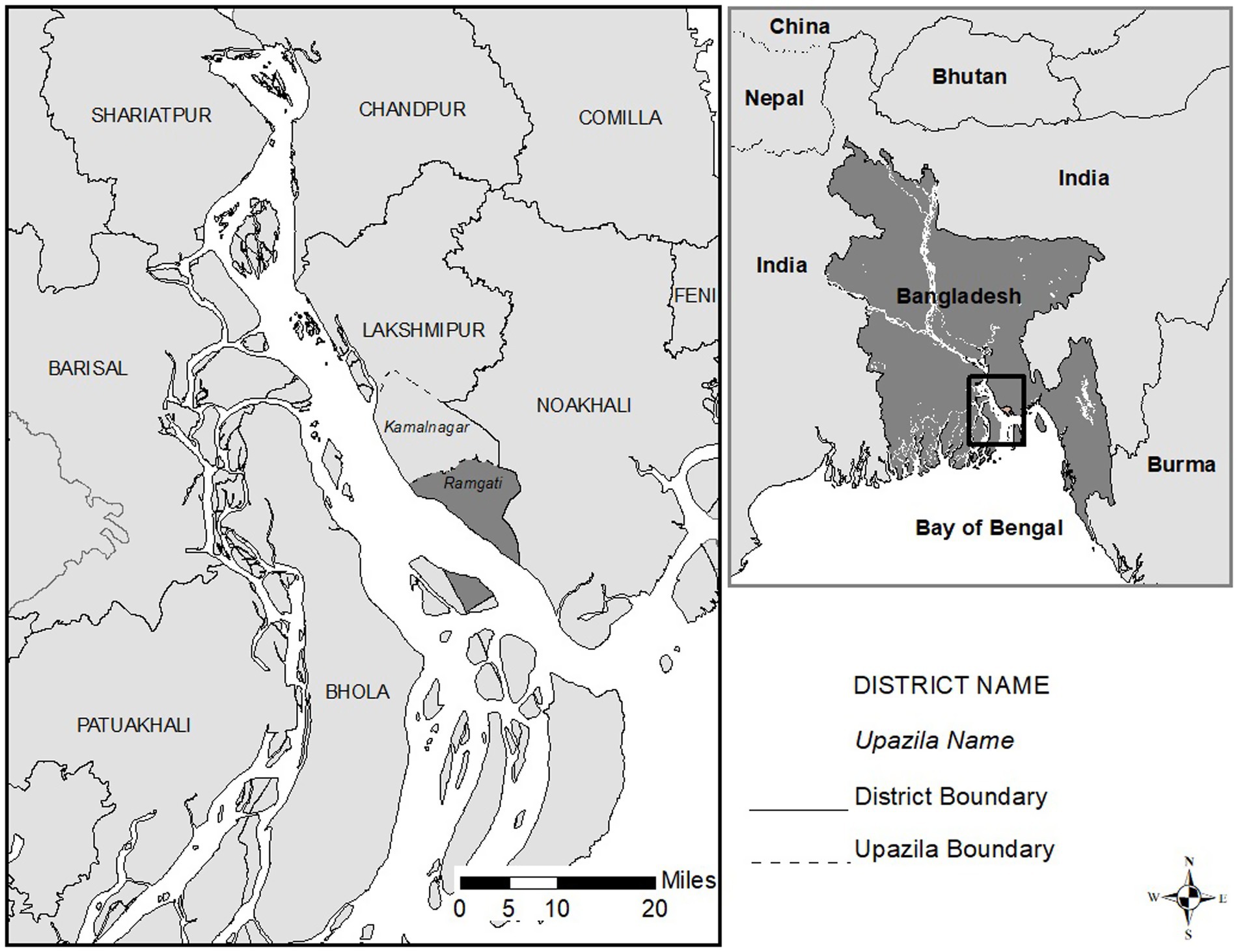
Figure 1. Study site.
In presenting our findings, we draw from a growing body of literature in the social sciences to characterize our setting as hydrosocial, a theoretical lens that acknowledges the intertwined dynamics of hydrological process and social-ecological change. A hydrosocial framing, we hope to show, can assist us in understanding the ways in which livelihoods and perceptions in this part of the MGB delta are in constant negotiation with the agencies and hazards of the river, and with the infrastructures intended to tame them. The remainder of the paper is structured as follows. We first survey the traditional literature on riverbank erosion in Bangladesh and put forward a contrasting lens focused around recent literature on hydrosocial relations and territories. We then provide an account of our research site and methodology, and present results that illustrate how local residents craft lives from the riverine environment and adapt to its risks. We draw out in particular the spatial dynamics associated with erosion-induced displacement and with the construction of the new concrete embankment. We close with some comments about the contributions of our case study toward understanding the assembling of hydrosocial life in delta environments.
Literature review
Traditional studies of riverbank erosion
Important early studies of riverbank erosion in Bangladesh were carried out by C. E. Haque and M. Q. Zaman and colleagues in the late 1980s (Haque, 1988; Haque and Hossain, 1988; Haque and Zaman, 1989; Zaman, 1989; Hutton and Haque, 2003; Hutton and Haque, 2004). This work, using survey methodology and focused primarily on char lands within the Jamuna River in central Bangladesh, produced significant insights into the dynamics of displacement resulting from riverbank erosion, and the coping mechanisms and ongoing challenges of displacees. Studies showed that many of those who lost their homes to the river were forced to reside temporarily with friends, family or wealthy patrons, and the research documented significant livelihood disruption and socioeconomic deterioration. A key finding in this work was that residents who lost their homes quickly colonized newly accreted char lands, often in nearby locations, but access to these lands was frequently controlled by local elites (Haque and Zaman, 1989) and violent conflicts over land were found to be common (Zaman, 1989). Baqee’s (1998) study from the lower Padma River produced similar findings, highlighting in particular the role of power-brokers in violent struggles over access to land.
A second prominent theme in this early work was the finding that char land and riverside households had few options for combating riverbank erosion, and as a result many had developed what Haque (1988, p. 434) called an “acceptance of loss and a fatalistic view toward the hazard,” with many attributing it simply to the ‘will of Allah’ (Hutton and Haque, 2003). As Haque and Hossain (1988, p. 26) put it, “as individuals or collectively as households there was little they could do against the awesome process of the mighty Brahmaputra.” Baqee (1998, p. 2) was even more pessimistic in his assessment, writing that “helplessness, resignation and surrender to forces unleashed by them in their struggle for existence—but over which they have no control—mark the lives of the char-lands denizens.” In recognition of this lack of control, Baqee characterized the chars of his study as the ‘land of Allah Jaane,’ or ‘God knows’.
More recent work has sought to moderate this assessment by attributing a greater sense of agency to households affected by riverbank erosion. Lein (2009), for example, acknowledges that choura communities suffer from marginalization and low social status, but also points to their unique culture and livelihoods characterized by mobility and adaptation. Many char communities along the Jamuna River, he argues, share a collective ethos and sense of social cohesion. “It is clear,” Lein (2009, p. 100) concludes, “that people settle on char land because it is possible to obtain a decent and sustainable livelihood there.” Rather than view floodplain inhabitants as passive victims of an inexorable force, then, it may be more accurate to suggest that “riverine hazards have been integrated into daily life” through intentional livelihood and coping strategies (Hutton and Haque, 2003, p. 412).
This is not to deny the very real challenges faced by char and riverside communities, and especially by households displaced by riverbank erosion, as detailed in a number of studies in recent years. Substantial riverbank erosion has been documented in many regions of Bangladesh, including the Teesta and Brahmaputra floodplains in the north of the country (Islam, 2018; Sultana et al., 2020), the Jamuna and Padma Rivers in the central region (Billah et al., 2023; Alam et al., 2017; Bhuiyan et al., 2017; Alam et al., 2018), and the Lower Meghna River and the Sundarban regions of the coastal zone (Parvin et al., 2008; de Wilde, 2011; Akter et al., 2019; Rahman and Gain, 2020). Studies describe a range of coping strategies. Some displacees opt to remain in the vicinity of their former homestead to take advantage of available livelihood opportunities afforded by the river and its environs (Hutton and Haque, 2004; Paul et al., 2022). Others have no choice but to seek emergency shelter elsewhere and/or adopt new livelihood strategies, including long-distance migration and part-time employment (Parvin et al., 2008; Tanvir Rahman et al., 2015; Bhuiyan et al., 2017; Abdur Rahim et al., 2024).
In either case, the impacts can be substantial for communities affected by riverbank erosion. Alam et al. (2017, p. 31), for example, found what they describe as a “vicious circle of vulnerability” among char dwellers in the Jamuna River floodplain, with challenges including food insecurity and comparatively low levels of health and well-being. In their research in the Sundarbans region, Rahman and Gain (2020) also documented negative impacts on food security, along with loss of income and children being forced to drop out of school. Akter et al. (2019), in one of the few studies focused on the lower Meghna, found that women face particular challenges in the aftermath of erosion displacement, in part because women’s income-generating opportunities are often based in the home.
Taken as a whole, these and other empirical studies from Bangladesh have derived significant insights into the impacts and the adaptive responses of communities living in complex delta environments. Conceptually, the tendency in this work has been to frame the dynamic of flooding and riverbank erosion in the traditional hazard response vein, as a process of household adjustment to an external hazardous environment. We propose that this view can be productively supplemented by a framework that understands human-environment relations as mutually constituted. Here, we turn to recent scholarship on hydrosocial relations, environments and infrastructures (Haeffner et al., 2024). Such a perspective, we suggest, can provide new ways of thinking about the land-water interface, and new understandings of the lives and livelihoods crafted amidst the fluxes of deltaic change.
Toward a hydrosocial view of riverbank erosion
As noted above, the traditional literature has tended to focus on the household response to the erosion hazard, in which the river’s water displaces land and livelihood. This approach can be understood to be built upon a series of unacknowledged land-water binaries—solid/fluid, stable/in flux, enduring/ephemeral—that may not effectively capture the dynamic and ever-changing environment characteristic of Bangladesh’s floodplains and delta region. We are drawn to recent scholarship characterizing such environments as hybrid, constituted by the constant intermixing of land and water, and of natural and social processes. In her work on the Bengal delta in India, for example, Lahiri-Dutt (2014, p. 507) has noted that “hybrid water/lands … constitute a blend of water and land where the two are merged with each other imperceptibly and changeably.” Micheaux et al. (2018) extend Lahiri-Dutt’s insights, pointing to the role of sediments in constituting the materiality of charlands in the lower Ganges basin of India. “These chars,” the authors suggest, “evolve not as landscapes or waterscapes, but as composite muddyscapes … [they] exemplify instances of water-sediment dynamic relations” (Micheaux et al., 2018, p. 643).
The hybrid character of deltaic muddyscapes can be extended to characterize their river-society interactions, the ongoing interplay of hydrological processes and social relations as local livelihood practices evolve in tandem with changing environmental conditions. Recent work in cultural anthropology has provided theoretical insight on this point. Krause and Strang (2016, p. 633), for example, in their introduction to a special collection on ‘thinking relationships through water’, emphasize that “social and hydrological relationships are interconnected and mutually constitutive.” Recent work in the Bangladesh context has also begun to acknowledge these intertwined social-environmental dynamics, particularly in the country’s delta region. Nicholls et al. (2016, p. 374) for example, characterize the GBM delta as “a mosaic of diverse social-ecological systems” and Crawford et al. (2020a) theorize the lower Meghna estuary as a ‘coupled human-natural system’ shaped by a succession of ‘adaptive cycles’ linking shoreline change and livelihood responses.
The phenomenon of riverbank erosion provides a particularly vivid illustration of the hybrid and changing nature of delta environments. As Hutton and Haque pointed out in their early work, hazards such as riverbank erosion are “products of an interface between the physical environment, on one hand, and people’s economic, social, and political vulnerabilities and capacities on the other” (Hutton and Haque, 2003, p. 419). More recent approaches have blurred these boundaries even further, developing a phenomenological understanding of muddyscapes and their inhabitants. As Bowles et al. (2019) put it:
“Looking from the water, the land looks hard to separate from it as water laps at boundaries, erodes territories, breaks its banks and literally muddies its certainties … it is clear that many people are positioned somewhere between the solidity of land and the fluidity of water, and that their sociality comes to be shaped by this constant negotiation and engagement” (pp. 8–9).
It is important to note that this ‘constant negotiation’ can have various and uneven outcomes, and researchers need, therefore, to be attentive to spatial differences within the society-water–sediment interface and the hazards that it produces. Boelens et al. (2016), for example, develop the notion of hydrosocial territories to explore the inequities within particular configurations of hydrologic flows, social and material infrastructures, and systems of governance. Thinking in terms of hydrosocial territories, they suggest, can bring to the fore the material and geographical expression of water-society relations, and call attention to “processes of inclusion and exclusion, development and marginalization, and the distribution of benefits and burdens that affect different groups of people in distinct ways” (Boelens et al., 2016, p. 2; see also Houart et al., 2024). Drawing inspiration from Boelens et al., we characterize our research site as a hydrosocial territory, which we define as a dynamic set of spatial relationships encompassing livelihood practices, socioeconomic patterns and infrastructures that are shaped and conditioned by flows of water. With this approach, we hope to be able to capture the uneven geographical manifestations of environmental change, perception and adaptation that define life in the GBM delta.
A final insight that we draw from recent scholarship is that hydrosocial territories and relations—particularly in delta regions—are mediated in significant ways by various forms of infrastructure and technology, including dams, dikes, sluices, irrigation canals, spurs, guide bunds, revetments, and more. As Morita (2016, p. 119) suggests, “in the amphibious delta environment, managing water flows is particularly important for transforming the environment in order to make it favorable for particular types of human activities.” Bangladesh’s delta region has a long history of such interventions, and at various scales (Dewan et al., 2015). Large scale infrastructures include hydroelectric dams in the upper reaches of the delta and extensive land reclamation projects in the south based upon the Dutch dike system (Gain et al., 2017). At a more local scale, systematic efforts at shoreline hardening began to take shape in the 1990s, and since that time a patchwork of spurs and revetments has been constructed to control the erosion of riverbanks in strategic locations (Oberhagemann et al., 2020). Whether large or small, these infrastructural interventions have played an important role in shaping hydrosocial territories and livelihoods with the GBM delta. Indeed, Welch et al. (2017) have gone so far as to suggest that long-term deltaic change is best conceived as a ‘coevolution’ of physical systems and engineered adaptations and infrastructures.
As our brief conceptual review suggests, we believe that the hydrosocial can be a useful approach for understanding water-society relationships, territories and infrastructures (Di Tullio and Zannini, 2025). Researchers have successfully applied this framework in a range of empirical settings, including Andean South America, Brazil, East Asia, and the US Southwest (for a review of the literature, see Flamino et al., 2022; Liao and Schmidt, 2023; Alba et al., 2025). But application of a hydrosocial approach has not been common in the literature on riverine livelihoods and hazards in Bangladesh (though Ferdous et al. (2018) is a notable example). In what follows, we use a hydrosocial lens to interpret results from a qualitative case study from the southern Delta region of Bangladesh. In so doing, we hope to suggest some of the ways that residents fashion their lives and subjective understandings at the ever-changing interface between land and water.
Research site and methodology
As noted above, our research is focused on the upazila of Ramgati, situated along the east bank of the Meghna River (Figure 1). Our study is part of a larger project examining multiple dimensions of riverbank erosion along the lower portion of the estuary. The site was chosen due to the prominence of the erosion hazard in this area, as well as the presence of several concrete revetments built to protect the shoreline. Previous studies from the project have examined the pace and dynamics of shoreline change, erosion-induced migration, and resident hazard perception (Crawford et al., 2020a,b; Paul et al. 2020, 2021; Rahman et al., 2021; Rahman et al., 2022). The present paper complements this body of work, providing a qualitative assessment of local livelihood dynamics and subjective understandings of riverbank erosion and the recently-built revetment.
Our findings draw predominantly from 24 in-depth interviews, 18 with household heads and six with key informants, including local school and college teachers and government officials (Table 1). The interviewees were identified through convenience and snowball sampling. The 18 households were selected on the basis of location and occupation. Six interviews were conducted each with farmers, fishers and business owners. Of these, two in each group live in the area now protected by the revetment, with two more each residing in unprotected areas to the north and south. All household interview respondents were men, and this precludes us from a consideration of the gender dynamics of local perceptions and livelihoods. Of the key informant interviews, four were with men and two with women.
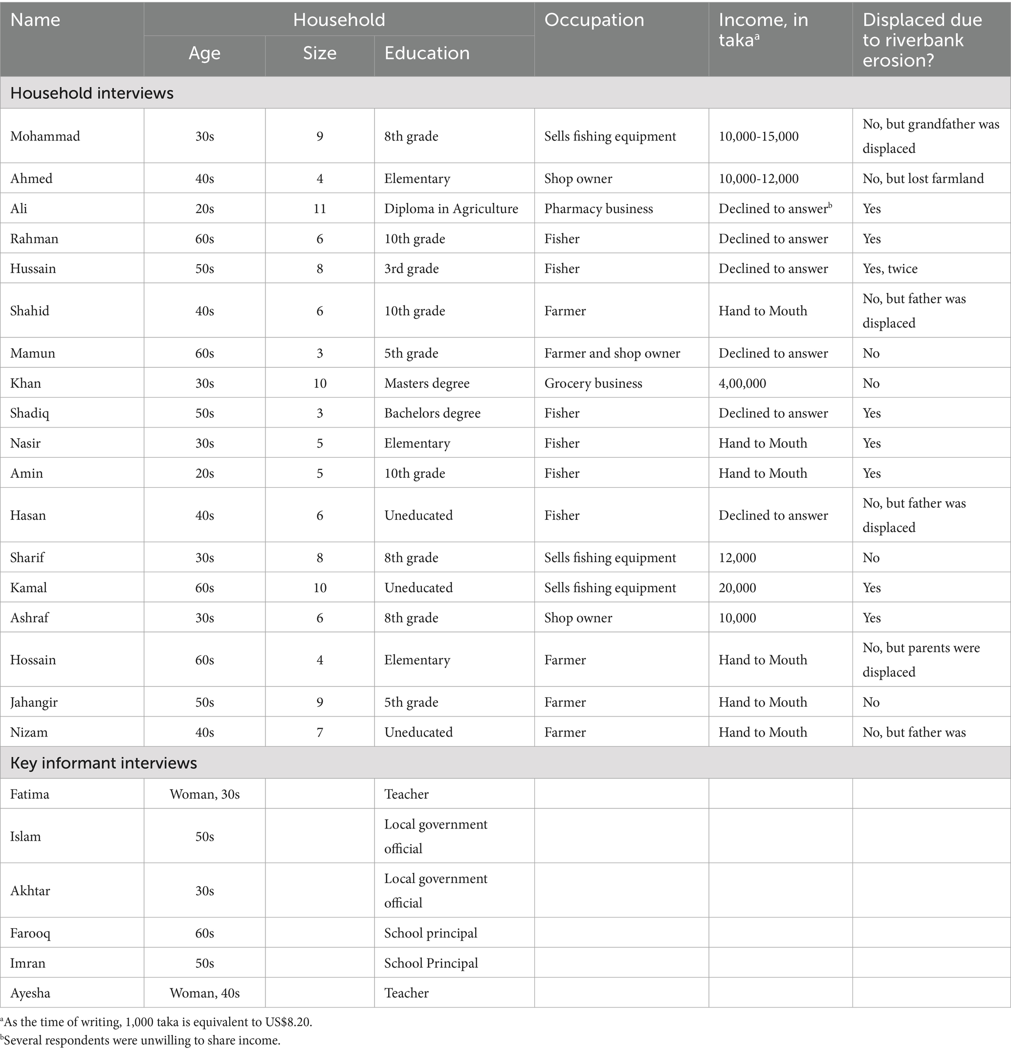
Table 1. List of interview respondents.
The interviews, lasting between 30 and 50 min, were conducted by one of the authors (Rahman) using a semi-structured interview guide. Questions focused on living conditions and livelihood patterns, perceptions of riverbank erosion and its impact on the community, and views regarding the new revetment. The conversations were recorded in Bangla, and subsequently transcribed, translated into English, and then coded for prominent themes related to hazard perception, livelihood dynamics, and infrastructure. In interpreting our results, we supplement interviews with data from a survey of 381 randomly-selected households in Ramgati upazila. The survey, which was designed and carried out as part of the larger project, focused on household experiences with, responses to, and perceptions of riverbank erosion. Survey results are discussed in more detail in Rahman et al. (2022).
Findings and discussion
Hydrosocial histories and livelihoods
In both its history and contemporary dynamics, the hydrosocial environment of Ramgati and nearby areas is aptly characterized as a hybrid and changing ‘muddyscape’. The land that is now Ramgati was in the mid-twentieth century a char island that over time became connected to the mainland as a result of sedimentation (Brammer, 2014). This process was facilitated by the construction of two cross-dams, which accelerated the natural accretion process and resulted in some 1,000 km2 of reclaimed land (Carvajal et al., 2011). According to oral histories provided by key informants, many of Ramgati’s 229,000 residents are descendants of settlers who arrived from the neighboring districts of either Noakhali (to the immediate South) or Bhola (across the river on the west bank) to claim these emergent lands after suffering the loss of their homes to riverbank erosion. These historical hydrosocial dynamics shape the contemporary social and cultural geographies of Ramgati, as the descendants of these two migrant streams are today known locally by different names and can be identified by differences in language and custom.
Everyday life in Ramgati continues to be significantly shaped by water and sediments. Survey results show that just over half of households are headed by someone engaged in farming or fishing, and interview responses provide additional evidence for the importance of the riverine environment to local livelihoods. Farming is productive throughout the fertile floodplain, where paddy rice is the predominant staple crop and farmers also grow lentils, green beans, peanuts and soybeans. There are in addition an estimated 20,000 fishers in the upazila, an activity that also provides a livelihood for those who make, lease or repair boats and equipment. Another 18% of households heads identified in the survey run small shops or businesses, and interview respondents indicated that many are highly dependent on local fishers and farmers for their customer base. Mohammad, who sells fishing equipment, commented that “my shop is near to the fish market, and that is good for my business. I have lot of customers and many of them are fishermen.” Another shop owner, Ahmed, stated that “my income always depends on the income of the fishers. If they catch a lot of fish, my income increases.”
It is clear, then, that notwithstanding the risk, the Meghna River and its environs can be a source of opportunity for local residents, and that many have crafted their livelihoods around its waters. As Fatima, a local teacher, put it, “the people here are industrious, and they have a lot of options to earn an income because of the mighty river … whether directly or indirectly, local people here are dependent on the river.” The opportunity afforded by the river is reflected in the fact that monthly household income among households surveyed averages 45% higher than in rural Bangladesh overall, at around 20,000 taka ($160 US). But it is also true that Ramgati faces significant development challenges, and the upazila has been estimated to have a ‘very high’ level of social vulnerability, according to one recent study based on an index of 13 socio-economic variables (Rahman et al., 2020).
The riverbank erosion hazard
According to interview respondents, the hazard posed by riverbank erosion is pervasive and shapes the fortunes of Ramgati residents to a considerable degree. A number of respondents recounted stories of personal loss. Said Ali, who runs a pharmacy, “twelve years ago we lost our house and we also lost more than 30 acres of land. After that we moved here. We had no other options. There is nothing you can do against this disaster.” Rahman, who works as a fisher, told us that “five years ago before I was displaced, I had a big house, lands, and other possessions. Now I have nothing. I lost everything.”
Several other respondents lamented the loss of land by parents and grandparents.
Hussain, for example, told us that:
“My father had a lot of land, but unfortunately it was all lost in the river. This has negatively affected my occupation. If my father had not lost his land, I could now have land to cultivate. I could grow my own rice and would not have to buy it. But as it is, I have no option but to fish in the river, and I only make some money when the fishing is successful. Now, I earn a very low income and it is difficult to support my family.”
As Hussain suggests, riverbank erosion is not only a concern of the present in Ramgati. By depriving households of inherited land, the agencies of the river have an inter-generational impact on Ramgati livelihood strategies and opportunities.
Our interviews make clear that even those residents who have not been directly affected by riverbank erosion often find its imminent threat to be a source of anxiety and stress. Mohammad told us:
“It is a huge concern. You can see, the river is very near to my house so I am always feeling tense. I feel that very soon I will lose my house, but I don’t know what I can do. I have no money or land. Where would I go? … My business is doing well right now, but if I lose my house I don’t know how can I survive. The only thing I could do is ask my neighbor for a place to stay. And if I move away from here, I would lose my business, which is my main source of income.”
Shahid expressed a similar sentiment, stating “obviously, I am always under stress. I am about to lose my house, my possessions, and my agricultural land. What will I do after losing everything?”.
For those who do lose their house to riverbank erosion, the most immediate consequence is displacement and the need to find a new place to stay. A local proverb has it that a fire may burn your house down, but at least the land remains on which to rebuild. But with riverbank erosion, everything—even the land—is lost. According to our respondents, forced relocation poses not only immediate practical challenges, it also severs long-established social connections. Khan observed that “when people lose their house, they lose their social connections, and when they are forced to move somewhere else they are no longer a part of the community.” Mamun made a similar comment, noting that “[displacees] end up barely surviving. The new community often does not accept them and they are treated poorly. We tend to describe them using a slang term for ‘refugee’.”
Another finding from our interview data is that the impacts from the erosion hazard are not limited to displaced households, but reverberate throughout the local economy. Mamun, who runs a local shop, relayed:
“When my customers lose their house, they move away from here and sometimes they cannot pay me. Ultimately, that has an effect on my business. Even so, I don’t feel that I can ask or force them to pay me back. How could I, when I see that they are in very bad situation, living hand to mouth?”
In this way, the threat of riverbank erosion has a compound effect that inhibits the dynamism of the regional economy. A school principal, Islam, told us that:
“[Ramgati] is an underprivileged area. If you go around the area, you will see that there are no banks here. People have very little money. The area faces constant risk of erosion, so investors are not interested to buy land or do development work here.”
It is no wonder, then, that Hasan described riverbank erosion as a “curse,” and Nasir referred to it as something “hanging around the neck of the people,” concluding that “directly or indirectly all of the people of Ramgati are affected by this problem.”
The social and spatial variability of hydrosocial livelihoods
While nearly all residents are affected by riverbank erosion, our respondents made clear that the ability to cope with or respond to its impacts varies significantly. As we noted above, one of the features of recent work using hydrosocial concepts is attention to the uneven ways in which water-society relationships unfold. Findings from our interviews in Ramgati suggest that wealth may play a role in both exposure to riverbank erosion and the ability to cope with its aftermath. Mohammad noted that:
“The number of people affected is countless. Some people rebuild here, whereas others migrate to the city and work as day laborers. Those who are rich are still doing well after experiencing erosion, but those who are poor are suffering.”
Nasir spoke in similar terms:
“Thousands of people have been impacted. Some are doing badly, others are doing fine. It depends on their income. Those who have a good income, by the blessing of Allah they are doing well now. But most of the people are suffering.”
Islam, the school principal, offered personal testimony on this point, indicating that “I lost my house, but I am still in a good position because I have a good government job and earn a substantial salary.” In addition to influencing the ability to recover after loss, economic standing may also have a spatial dimension, with wealthier households more able to avoid residing in risk-prone areas close to river. “Some rich people build a good house far from the river,” stated Farooq, “and then they have a temporary house here for doing their business.” Akhtar noted similarly that “people who are wealthy do not live here. As soon as their income increases enough, they leave the area. So the people who are living here are mostly poor.”
Data from our study suggest that the uneven spatial expression of wealth noted in these responses also plays a part in erosion-induced displacement and resettlement, though only partially. One interesting finding from the survey is that Ramgati households who had previously experienced riverbank erosion live closer to the river’s edge than those who had not (769 meters on average versus 1,274 meters), and thus face greater hazard exposure. Interview responses suggest that there may be two interrelated reasons for this. First, it may reflect a lack of available options, especially for those who are not wealthy. As Amin, a local fisher who had himself experienced dislocation, explained:
“I know many families who lost their houses like we did. Many rich people, those who have land and money, were able to build new houses. But the poor people are still living here near to the riverbank. Poor people don’t have the option of going somewhere else.”
Another fisher, Hasan, concurred, observing that:
“The rich who have money, they usually build new houses and move somewhere else. But the poor people cannot move away from here, so they just try to stay near to the river. They may try to arrange with their neighbor to get a place to stay for free.”
Other interviewees pointed to an alternative dynamic, suggesting that relocating close to the river can be a deliberate strategy for those whose livelihood depends upon the river and its resources. In the words of Farooq:
“People who are earning good money from the river don’t care about the problem of erosion. They simply build a house in another place. So they are not scared like the rest of us. They think the river is a blessing.”
Our findings suggest that this may be particularly true for fishers. As Shadiq relayed, “when fishers are displaced, they do not usually move to another upazila. Most of them are living in the same area and continue in fishing or a fishing-related job.” Fatima expressed a similar sentiment, noting that people who are displaced are simply “trying to cope with reality … people who are directly or indirectly dependent upon the river do not usually change their occupation after losing their houses to the river.” Data from the household survey would appear to back this up, as only 8% of those experiencing displacement as a result of riverbank erosion reported changing their occupation in response. As Nasir quipped, “the bank may be eroding, but the river still has fish.”
The impact of infrastructure on hydrosocial relations
As noted previously, Ramgati is noteworthy for the existence of a concrete revetment, which was constructed in 2017 to guard a portion of the upazila against riverbank erosion. The revetment now protects the area’s primary institutional infrastructure (civic buildings, schools, a hospital and the main market) along roughly two miles of shoreline. Homes and lands that are located inland from the revetment are now much more heavily protected from flooding and erosion than areas to the north and south along the Meghna’s banks. This context provides a unique opportunity to study local resident perceptions of the riverbank erosion hazard, and to examine the spatial variability of this perception across areas that are now protected by the embankment and those that are not.
For most of our interview respondents, the revetment is seen as a highly positive development. In addition to protecting Ramgati’s central government and commercial district, the revetment has become a recreation site. Akhtar, a local government official, indicated to us that “we are trying to attract more tourists by establishing some opportunities and facilities … local businesses have benefitted due to the visitors.” Khan, who runs a grocery store, agreed, stating that:
“Before they built this revetment, our business had been suffering for 5 or 6 years due to erosion. But now with the revetment, our business is doing well again. Actually, this revetment has brought a lot of changes in our daily life. Everything is going well now.”
Notwithstanding this generally positive sentiment, respondents also expressed a clear understanding of the spatial variability of risk. This is particularly true for those who remain unprotected and are still vulnerable to riverbank erosion. Hasan, a local farmer, commented that “yes, they are in a safe zone but we are not safe. We are in bad situation and always feel we are at risk … we feel bad because they now have the revetment but we do not.” For their part, respondents now protected by the revetment tend to acknowledge their good fortune, but this is often tempered by a recognition that there is only so much that human engineering can accomplish in the face of riverbank erosion. As Kamal put it, “we are satisfied with this revetment and now we feel protected. I feel good now. But Allah is all-knowing and can do anything, and if he wants he can destroy everything.” Sharif expressed a similar sentiment:
“By the grace of the almighty we are now protected by this revetment. But if Allah wants, it can be destroyed. I am aware of a strong revetment in Bhola district that was destroyed. So it all depends on the Almighty.”
As these statements reflect, and as previous research from Bangladesh has demonstrated, local understandings of risk are often accompanied by a perception that the ability to intervene in the river’s hydrologic forces, even in the case of engineered infrastructure, may be limited and precarious, subject ultimately to the ‘will of Allah’. “We have a high degree of risk,” said Ali, “the river is only one mile away from here. By the grace of the almighty, we are still here. But if it is the will of Allah, we can lose everything in the river.”
As we noted above, these kinds of statements have at times been interpreted in the literature as a form of passive resignation. But our case study demonstrates that local residents exercise significant agency in crafting their livelihoods in concert with the river and its hydrodynamics. We might therefore attribute reference to Allah’s will not to a passive fatalism, but rather to attunement to the river’s dynamics born of generations of learning to adapt to life in the GBM delta. As other scholars have shown, and as our interview data help to capture, riverside residents have developed intentional and resourceful forms of dwelling within a hydrosocial environment characterized by an ever-changing landscape of opportunity and risk.
Conclusion
Taken together, our case study offers a glimpse into some of the livelihood practices and hazard perceptions of residents living in a delta setting characterized by environmental change and risk. In interpreting this, we suggest that Ramgati can be usefully described as a hydrosocial territory, its residents dwelling in a hybrid and ever-evolving landscape at the boundary between land and water. The phenomenon of riverbank erosion represents the interface around which hydrosocial life revolves in Ramgati in several key respects, as illustrated by our qualitative data.
First, it is clear that the river plays a key role in providing livelihood avenues and some measure of economic opportunity for the residents of Ramgati. For generations, families have negotiated with the river and its geophysical properties for settlement, agriculture, fishing and related activities. These intertwined social and environmental dynamics help us “rethink sediment beyond its physical-geomorphological existence and perceive it as a site of social interaction … [that is] bestowed with rich ecosystem services and the collective resilience of choruas” (Mukherjee and Ghosh, 2020, p. 136).
At the same time however, generations of the region’s residents have been forced to contend with the ever-present reality of riverbank erosion. Scores of riverside dwellers have lost homes and property to the river, and many others face the prospect of future loss and the anxiety that comes with it. In line with previous studies, our results suggest that many of those who are displaced, whether drawn by opportunity or forced by circumstances, return to hazardous locations near the unprotected shoreline. The picture that is painted by our respondents is one of constant churning, not only of currents and sediments, but of households and livelihood activities as well. Our case study in this way exemplifies the observation of Krause and Harris (2021b, p. 222) that “the delta itself is not a given in people’s lives, but is made by their activities and the currents that they interact with: flows into, out of and through delta people’s homes and livelihoods.”
Our case study also shows that substantial inequalities lie within this environment. The hydrosocial territory of Ramgati is experienced differently by households depending on wealth and location, with some residents more able than others to avoid or adapt to its hazards. With greater wealth comes increased opportunity to rebuild after displacement or to live in less hazardous areas. Construction of the revetment has further altered the landscape of risk in Ramgati, creating new levels of relative security for some and for many more a heightened sense of inequality in exposure to the riverbank hazard. In this way, the revetment provides a good example of the ways in which infrastructures generate hydrosocial change. It reminds us that, as Krause and Harris (2021a) observe, the “social and material dynamism [of Delta regions] is due, in part, to the central role of water and sediment in people’s lives, regarding the institutions and infrastructures they develop to respond to these dynamics.”
Finally, our work hints at a certain subjective understanding of the inexorable force of the river’s powers of erosion and accretion, and an acknowledgement that even the human intervention of a concrete barrier may not be able to overcome the will of Allah. This should not be mistaken in our view for passivity or resignation, for riverside dwellers have shown themselves to be active agents who have crafted unique hybrid livelihoods from within the Meghna floodplains. By drawing out the stories and perspectives of those who reside in one locale along the banks of the Meghna River, our case study provides some insight into what Bowles et al. (2019, p. 6) refer to as ‘dwelling’ within a particular hydrosocial territory, “an opportunity to really bring to the fore that which is special about lives lived in the flow of waters.”
Data availability statement
The datasets presented in this article are not readily available because data are qualitative interview files–possible disclosure of sensitive information. Requests to access the datasets should be directed to cG9wa2VlQGVjdS5lZHU=.
Ethics statement
The studies involving humans were approved by University and Medical Center IRB (UMCIRB), East Carolina University. The studies were conducted in accordance with the local legislation and institutional requirements. The ethics committee/institutional review board waived the requirement of written informed consent for participation from the participants or the participants’ legal guardians/next of kin because research in foreign country, limited literacy and hindrance to participation. Informed consent was obtained verbally.
Author contributions
JP: Supervision, Writing – review & editing, Conceptualization, Writing – original draft. MR: Investigation, Writing – review & editing, Methodology, Data curation.
Funding
The author(s) declare that financial support was received for the research and/or publication of this article. This research was supported by a grant from the National Science Foundation (#1660447).
Conflict of interest
The authors declare that the research was conducted in the absence of any commercial or financial relationships that could be construed as a potential conflict of interest.
Generative AI statement
The authors declare that no Gen AI was used in the creation of this manuscript.
Publisher’s note
All claims expressed in this article are solely those of the authors and do not necessarily represent those of their affiliated organizations, or those of the publisher, the editors and the reviewers. Any product that may be evaluated in this article, or claim that may be made by its manufacturer, is not guaranteed or endorsed by the publisher.
References
Abdur Rahim, M., Akter, B., and Hasan Rakib, M. (2024). Assessment of socio-economic impacts of river bank erosion: enhancing resilience in the Coastal Belt of Bangladesh. J. Environ. Dev. 33, 583–612. doi: 10.1177/10704965241246710
Akter, K., Dey, S., and Hasan, S. (2019). Riverbank erosion and its impact on rural women: case study of Ulania village in Bangladesh. Asian J. Women's Stud. 25, 76–95. doi: 10.1080/12259276.2019.1577343
Alam, G. M. M., Alam, K., Mushtaq, S., and Clarke, M. (2017). Vulnerability to climatic change in riparian char and river-bank households in Bangladesh: implication for policy, livelihoods and social development. Ecol. Indic. 72, 23–32. doi: 10.1016/j.ecolind.2016.06.045
Alam, G. M. M., Alam, K., Mushtaq, S., and Filho, W. L. (2018). How do climate change and associated hazards impact the resilience of riparian rural communities in Bangladesh? Policy implications for livelihood development. Environ. Sci. Pol. 84, 7–18. doi: 10.1016/j.envsci.2018.02.012
Alba, R., Alarcon, L. B., Prado, M. P., Villa, U. J., and Ortiz-Guerrero, C. E. (2025). Hydrosocial territories research: an overview. Wiley Interdiscip. Rev. Water 12:e70023. doi: 10.1002/wat2.70023
Baqee, A. (1998). Peopling in the land of Allah Jaane: power, peopling and environment: the case of char-lands of Bangladesh. Dhaka: The University Press Limited.
Bhuiyan, M. A. H., Islam, S. M. D.-U., and Azam, G. (2017). Exploring impacts and livelihood vulnerability of riverbank erosion hazard among rural household along the river Padma of Bangladesh. Environ. Syst. Res. 6, 1–15. doi: 10.1186/s40068-017-0102-9
Billah, M., Majumdar, A., Rahman, S. M. A., Alam, M. S., Hossain, M. J., Talukder, J., et al. (2023). Riverbank erosion and rural food security in Bangladesh. World 4, 528–544. doi: 10.3390/world4030033
Boelens, R., Hoogesteger, J., Swyngedouw, E., Vos, J., and Wester, P. (2016). Hydrosocial territories: a political ecology perspective. Water Int. 41, 1–14. doi: 10.1080/02508060.2016.1134898
Bowles, B. O. L., Kaaristo, M., and Caf, N. R. (2019). Dwelling on and with water–materialities, (im)mobilities and meanings: introduction to the special issue. Anthropol. Notebooks 25, 5–12.
Brammer, H. (2014). Bangladesh’s dynamic coastal regions and sea-level rise. Clim. Risk Manag. 1, 51–62. doi: 10.1016/j.crm.2013.10.001
Carvajal, I. F., Khan, Z. H., and Rahman, M. M. (2011). “Land formation and erosion in the estuary” in Moving coastlines: emergence and use of land in the Ganges-Brahmaputra-Meghna estuary. ed. K. de Wil (Dhaka: University Press Limited), 21–37.
Crawford, T. W., Islam, M. S., Rahman, M. K., Paul, B. K., Curtis, S., Miah, M. G., et al. (2020b). Coastal erosion and human perceptions of revetment protection in the lower Meghna estuary of Bangladesh. Remote Sens 12:3108. doi: 10.3390/rs12183108
Crawford, T. W., Rahman, M. K., Miah, M. G., Islam, M. R., Paul, B. K., Curtis, S., et al. (2020a). Coupled adaptive cycles of shoreline change and households in deltaic Bangladesh: analysis of a 30-year shoreline change record and recent population impacts. Ann. Am. Assoc. Geogr. 111, 1002–1024. doi: 10.1080/24694452.2020.1799746
de Wilde, K. (2011). “Conclusion: taking stock and looking forward” in Moving coastlines: emergence and use of land in the Ganges-Brahmaputra-Meghna estuary. ed. K. de Wil (Dhaka: University Press Limited), 219–229.
Dewan, C., Mukherji, A., and Buisson, M.-C. (2015). Evolution of water management in coastal Bangladesh: from participatory earthen embankments to depoliticized community-managed polders. Water Int. 40, 401–416. doi: 10.1080/02508060.2015.1025196
Di Tullio, V., and Zannini, L. (2025). Unveiling hydrosocial dynamics: discourse and power in Peña Blanca. Front. Environ. Sci. 12:1502191. doi: 10.3389/fenvs.2024.1502191
Ferdous, M. R., Wesselink, A., Brandimarte, L., Slager, K., Zwarteveen, M., and Di Baldassarre, G. (2018). Soci-hydrological spaces in the Jamuna River floodplain in Bangladesh. Hydrol. Earth Syst. Sci. 22, 5159–5173. doi: 10.5194/hess-22-5159-2018
Flamino, S., Rouillé-Kielo, G., and Le Visage, S. (2022). Waterscapes and hydrosocial territories: thinking space in political ecologies of water. Progr. Environ. Geogr. 1, 33–57. doi: 10.1177/27539687221106796
Gain, A. K., Mondal, M. S., and Rahman, R. (2017). From flood control to water management: a journey of Bangladesh towards integrated water resources management. Water 9:55. doi: 10.3390/w9010055
Haeffner, M., Lave, R., Linton, J., Mukherjee, J., Ndiritu, J., Pachelco-Vega, R., et al. (2024). Innovating a new knowledge base for water justice studies: hydrosocial, sociohydrology, and beyond. Front. Water 6:1389030. doi: 10.3389/frwa.2024.1389030
Haque, C. E. (1988). Human adjustments to river bank erosion hazard in the Jamuna floodplain, Bangladesh. Hum. Ecol. 16, 421–437. doi: 10.1007/BF00891651
Haque, C. E., and Hossain, M. Z. (1988). Riverbank erosion in Bangladesh. Geogr. Rev. 78, 20–31. doi: 10.2307/214303
Haque, C. E., and Zaman, M. Q. (1989). Coping with riverbank erosion hazard and displacement in Bangladesh: survival strategies and adjustments. Disasters 13, 300–314. doi: 10.1111/j.1467-7717.1989.tb00724.x
Houart, C., Hoogesteger, J., and Boelens, R. (2024). Power and politics across species boundaries: towards multispecies justice in riverine hydrosocial territories. Environ. Polit. 34, 49–69. doi: 10.1080/09644016.2024.2345561
Hutton, D., and Haque, C. E. (2003). Patterns of coping and adaptation among erosion-induced displaces in Bangladesh: implications for hazard analysis and mitigation. Nat. Hazards 29, 405–421. doi: 10.1023/A:1024723228041
Hutton, D., and Haque, C. E. (2004). Human vulnerability, dislocation and resettlement: adaptation processes of river-bank erosion-induced displacees in Bangladesh. Disasters 28, 41–62
Ishtiaque, A., Sangwan, N., and Yu, D. J. (2017). Robust-yet-fragile nature of partly engineered social-ecological systems: a case study of coastal Bangladesh. Ecol. Soc. 22:Art. 5. doi: 10.5751/ES-09186-220305
Islam, M. R. (2018). Climate change, natural disasters and socioeconomic livelihood vulnerabilities: migration decision among the char land people in Bangladesh. Soc. Indic. Res. 136, 575–593. doi: 10.1007/s11205-017-1563-y
Krause, F., and Harris, M. (2021a). “Life at water’s edge” in Delta life: exploring dynamic environments where rivers meet the sea. eds. F. Krause and M. Harris (New York: Berghahn), 1–24.
Krause, F., and Harris, M. (2021b). “Confluences and distributaries in delta life” in Delta life: exploring dynamic environments where rivers meet the sea. eds. F. Krause and M. Harris (New York: Berghahn), 222–230.
Krause, F., and Strang, V. (2016). Thinking relationships through water. Soc. Nat. Resour. 29, 633–638. doi: 10.1080/08941920.2016.1151714
Lahiri-Dutt, K. (2014). Beyond the water-land binary in geography: water/lands of Bengal re-visioning hybridity. ACME 13, 505–529. doi: 10.14288/acme.v13i3.1025
Lein, H. (2009). The poorest and most vulnerable? On hazards, livelihoods and labelling of riverine communities in Bangladesh. Singap. J. Trop. Geogr. 30, 98–113. doi: 10.1111/j.1467-9493.2008.00357.x
Liao, Y.-K., and Schmidt, J. (2023). Hydrosocial geographies: cycles, spaces and spheres on concern. Progr. Environ. Geogr. 2, 240–265. doi: 10.1177/27539687231201667
Micheaux, F. L.d., Mukherjee, J., and Kull, C. A. (2018). When hydrosociality encounters sediments: transformed lives and livelihoods in the lower basin of the Ganges River. Environ. Plan. E Nat. Space 1, 641–663. doi: 10.1177/2514848618813768
Morita, A. (2016). Infrastructuring amphibious space: the interplay of aquatic and terrestrial infrastructures in the Chao Phraya Delta in Thailand. Sci. Cult. 25, 117–140. doi: 10.1080/09505431.2015.1081502
Mukherjee, J., and Ghosh, P. (2020). Fluid epistemologies: the social saga of sediment in Bengal. Ecol. Econ. Soc. INSEE J. 3, 135–148. doi: 10.37773/ees.v3i2.222
Nicholls, R. J., Adger, W. N., Hutton, C. W., and Hanson, S. E. (2020a). Deltas in the Anthropocene. Cham: Palgrave Macmillan.
Nicholls, R. J., Adger, W. N., Hutton, C. W., and Hanson, S. E. (2020b). “Delta challenges and trade-offs from the Holocene to the Anthropocene” in Deltas in the Anthropocene. eds. R. J. Nicholls, W. N. Adger, C. W. Hutton, and S. E. Hanson (Cham: Palgrave Macmillan), 1–22.
Nicholls, R. J., Hutton, C. W., Lázár, A. N., Allan, A., Adger, W. N., Adams, H., et al. (2016). Integrated assessment of social and environmental sustainability dynamics in the Ganges-Brahmaputra-Meghna delta, Bangladesh. Estuar. Coast. Shelf Sci. 183, 370–381. doi: 10.1016/j.ecss.2016.08.017
Oberhagemann, K., Haque, A. M. A., and Thompson, A. (2020). A century of riverbank protection and river training in Bangladesh. Water 12:3018. doi: 10.3390/w12113018
Parvin, G. A., Takahashi, F., and Shaw, R. (2008). Coastal hazards and community-coping methods in Bangladesh. J. Coast. Conserv. 12, 181–193. doi: 10.1007/s11852-009-0044-0
Paul, B. K., Rahman, M. K., Lu, M., and Crawford, T. W. (2022). Household migration and intentions for future migration in the climate change vulnerable lower Meghna estuary of coastal Bangladesh. Sustain. For. 14:4686. doi: 10.3390/su14084686
Paul, B. K., Rhaman, M. K., Crawford, T., Curtis, S., Miah, M. G., Islam, M. R., et al. (2020). Explaining mobility using the community capital framework and place attachment concepts: a case study of riverbank erosion in the lower Meghna estuary, Bangladesh. Appl. Geogr. 125:102199. doi: 10.1016/j.apgeog.2020.102199
Paul, B. K., Rahman, M. K., Crawford, T., Curtis, S., Miah, M., and Islam, M. S. (2021). Coping strategies of people displaced by riverbank erosion in the Lower Meghna Estuary. In: Zaman, M., Alam, M. (eds) Living on the Edge: Char Dwellers in Bangladesh. Springer. 227–230.
Rahman, M. S., and Gain, A. (2020). Adaptation to river bank erosion induced displacement in Koyra Upazila of Bangladesh. Progr. Disaster Stud. 5, 1–8.
Rahman, M. K., Crawford, T. W., Paul, B. K., Islam, M. S., Curtis, S., and Mia, M. G. (2021). Riverbank erosions, coping strategies, and resilience thinking of the Lower-Meghna River Basin community, Bangladesh. In: Alam, G.M.M., Erdiaw-Kwasie, M.O., Nagy, G.J., Leal Filho, W. (eds) Climate Vulnerability and Resilience in the Global South. Springer. 259–278.
Rahman, M., Popke, J., and Crawford, T. W. (2022). Resident perceptions of riverbank erosion and shoreline protection: a mixed-methods case study from Bangladesh. Natural Hazards, 114 2767–2786. doi: 10.1007/s11069-022-05489-3
Rahman, M. M., Ghosh, T., Salehin, M., Ghosh, A., Haque, A., Hossain, M. A., et al. (2020). “Ganges-Brahmaputra-Meghna Delta, Bangladesh and India: a transnational mega-delta” in Deltas in the anthropocene. eds. R. J. Nicholls, W. N. Adger, C. W. Hutton, and S. E. Hanson (Cham: Palgrave Macmillan), 23–51. doi: 10.1016/j.pdisas.2019.100055
Sultana, P., Thompson, P. M., and Wesselink, A. (2020). Coping and resilience in riverine Bangladesh. Environ. Hazards. 19, 70–89. doi: 10.1080/17477891.2019.1665981
Tanvir Rahman, M. A., Islam, S., and Rahman, S. H. (2015). Coping with flood and riverbank erosion caused by climate change using livelihood resources: a case study of Bangladesh. Clim. Dev. 7, 185–191. doi: 10.1080/17565529.2014.910163
Welch, A. C., Nicholls, R. J., and Lázár, A. N. (2017). Evolving deltas: coevolution with engineered interventions. Elem. Sci. Anth. 5:49. doi: 10.1525/elementa.128
Zaman, M. Q. (1989). The social and political context of adjustment of riverbank erosion hazard and population resettlement in Bangladesh. Hum. Organ. 48, 196–205.
Keywords: hydrosocial, riverbank erosion, Bangladesh, livelihoods, river delta
Citation: Popke J and Rahman M (2025) Livelihood dynamics and hazard perception in a deltaic landscape: a hydrosocial assessment of riverbank erosion in the lower Meghna River, Bangladesh. Front. Water. 7:1634249. doi: 10.3389/frwa.2025.1634249
Edited by:
Maurizio Mazzoleni, VU Amsterdam, NetherlandsReviewed by:
Ying Zhu, Xi’an University of Architecture and Technology, ChinaYan Sun, Beijing Forestry University, China
Copyright © 2025 Popke and Rahman. This is an open-access article distributed under the terms of the Creative Commons Attribution License (CC BY). The use, distribution or reproduction in other forums is permitted, provided the original author(s) and the copyright owner(s) are credited and that the original publication in this journal is cited, in accordance with accepted academic practice. No use, distribution or reproduction is permitted which does not comply with these terms.
*Correspondence: Jeff Popke, cG9wa2VlQGVjdS5lZHU=