 Lorenzo Villani1*
 Giulio Castelli1
 Eleonora Forzini1
 Luigi Piemontese1
 Enrico Lucca1
 Ismail Bouizrou1,2Marco Lompi3Gabriele Bertoli3Alessandro Giuliano3Davide Danilo Chiarelli4
 Xenia Theodotou Schneider5
 Tommaso Pacetti3†
 Enrica Caporali3
 Elena Bresci1
- 1Department of Agriculture, Food, Environment and Forestry (DAGRI), University of Florence, Florence, Italy
- 2Institute of Ecology and Landscape, Hochschule Weihenstephan-Triesdorf University (HSWT), Freising, Germany
- 3Department of Civil and Environmental Engineering, University of Florence, Florence, Italy
- 4Department of Civil and Environmental Engineering, Politecnico di Milano, Milan, Italy
- 5XPRO Consulting Limited, Strovolos, Cyprus
The Mediterranean water sector faces multiple challenges. Climate change not only drives future water shortages but also drastically affects the effectiveness of water storage strategies, such as small and large reservoirs. Furthermore, the limited involvement of local actors often hampers the success of implemented solutions. We apply a co-modeling approach within the Val d'Orcia Rural Living Lab, to inform water planners about the potential impacts of climate change on reservoir water dynamics and to nourish the discussion on climate change adaptation. Specifically, we simulate various water storage strategies by alternatively considering existing small agricultural reservoirs (SmARs) and a planned large dam under current and projected future climates considering five climate models under the Shared Socioeconomic Pathway 585. Due to the reduced precipitation and increased temperature, future annual average water stored in both types of reservoirs is expected to decline (−6.3%) as a result of limited inflows (−30%) and enhanced evaporation (8.7%) by the end of the century. Moreover, seepage losses decrease (−9.8%) reducing aquifer recharge. While the trends in these key variables are consistent across storage types, SmARs are more susceptible to climate change, with water storage reductions of up to −21%. Evaporation losses increases are a major concern for the dam, whereas the reduction of inflows poses a major threat to the reliability of the smaller SmARs. Still, SmARs have several advantages and a more comprehensive and participatory analysis is important for appropriate decision-making. By involving local actors from the early stages, this research poses the basis for developing future best watershed management practices within a representative Mediterranean catchment.
1 Introduction
Rainfed agricultural production in the Mediterranean is threatened by increasing temperatures, enhanced evapotranspiration rates and more erratic rainfall patterns as a consequence of climate change (MedECC, 2020). Despite the usefulness of adaptation strategies (Bellini et al., 2023; Georgopoulou et al., 2024; Santos et al., 2020; Villani et al., 2024b), climate change impacts are expected to negatively affect crop yields and increase water use (Spano et al., 2020; Piano Nazionale di Adattamento ai Cambiamenti Climatici - PNACC, 2023). In Italy, a general reduction of crop yields, a lower quality of agricultural products as well as a Northward and upward shift of suitability areas is expected in the future (Piano Nazionale di Adattamento ai Cambiamenti Climatici - PNACC, 2023). While these trends are expected for most crop types such as pastures (Dibari et al., 2015) and arable herbaceous crops (Pulighe et al., 2024), the future sustainability of rainfed tree crops is particularly concerning (Moriondo et al., 2013; Piano Nazionale di Adattamento ai Cambiamenti Climatici - PNACC, 2023). Vineyards and olive groves characterize the pre-Apennine landscapes of Central and Southern Italy and its high-value agricultural products represent an asset for the Italian economy (ISMEA, 2024, 2025). Tree crops are considered more susceptible to climate change compared to herbaceous crops due to higher initial investment and maintenance costs and the years needed to reach maturity and marketable production (Piano Nazionale di Adattamento ai Cambiamenti Climatici - PNACC, 2023). Increased temperatures will possibly limit the fulfillment requirements of chilling units, anticipate the phenological phases and enhance the pest and disease risk with uncertain outcomes on yield quantity and quality, both for olive growing (Fraga et al., 2020; Orlandi et al., 2020) and viticulture (Alba et al., 2024; Fraga et al., 2016; Leolini et al., 2018). Climate change is extremely concerning for the high-value productions that are tightly connected with soil and climate characteristics of specific areas, such as certified winemaking (Jones et al., 2005; Moriondo et al., 2013; Santos et al., 2020). In addition to this, more erratic and uncertain precipitation and increasing drought periods projected for the future (Piano Nazionale di Adattamento ai Cambiamenti Climatici - PNACC, 2023) will further deteriorate the conditions for prosperous agriculture. While controlling and influencing climate variables, such as temperature, is unlikely, the expected aggravated water deficits can be met with irrigation. Where existing water resources are insufficient or already overexploited, increasing storage of rainfall and runoff can be a promising solution to supply irrigation water and cope with water stress in many parts of the world (Li S. et al., 2023; López-Felices et al., 2020; Schmitt et al., 2022; Wisser et al., 2010), including Italy (Casadei et al., 2019; Di Francesco et al., 2022; Napoli et al., 2014). Indeed, storing the water surplus in autumn and winter— when precipitation is the highest—and using it in summer—when crop water consumption is at its peak—is a viable strategy, given the possible future increases in winter precipitation and enhanced drought conditions (Spano et al., 2020; Piano Nazionale di Adattamento ai Cambiamenti Climatici - PNACC, 2023; Villani et al., 2024a).
Two main strategies for storing water in surface reservoirs can be identified (Keller et al., 2000). One relies on the use of large dams connected to an irrigation system that distributes water to a whole irrigation district and supplies water to multiple farms. Building new large dams has been one of the most common solutions to augment water supply in the past century and till now (Li Y. et al., 2023). The other one, less conventional, consists of numerous small agricultural reservoirs (SmARs) spread across the landscape. They typically harvest rainfall and the runoff of a small drainage area, providing water to one or a few farms (Degli Innocenti et al., 2025). Different thresholds are used in the world when defining how small a reservoir should be to be considered a SmAR. In Italy, a reservoir is considered small if the height of the dam is lower than or equal to 15 m or the storage volume is up to one million cubic meters (Casadei et al., 2019; Degli Innocenti et al., 2025). SmARs and large dams often coexist and are characterized by several common and peculiar issues (Blanc and Strobl, 2014; Jurik et al., 2015). Loss of water through evaporation (La Fuente et al., 2024; Mady et al., 2020; Rodrigues et al., 2023) and loss of storage capacity due to siltation (Degli Innocenti et al., 2025; Giambastiani et al., 2022; Licciardello et al., 2017; Pacetti et al., 2020b) are significant problems shared by both types of reservoirs. Large dams might face impelling problems when it comes to their construction, due to potential, often legitimate contrasts by local population, environmental concerns, the need to expropriate private land and potential disaster risks (e.g., Andráško et al., 2024; Huber et al., 2017; Mehta, 2001; Scaini et al., 2022; Schulz and Adams, 2021). Nevertheless, they are public, hence their management and maintenance can be potentially optimized. Although SmARs have many advantages compared to large dams, such as the lower amount of energy required to pump water (Nascimento et al., 2019), the easier management operations (Keller et al., 2000) and the potential for providing water in remote rural areas (Ebrahim et al., 2024; Meira Neto et al., 2024), they also have compelling drawbacks. Some negative aspects of smaller reservoirs relate to their higher greenhouse gas emissions (Holgerson and Raymond, 2016; Ollivier et al., 2019) and higher forest loss (Yang et al., 2024). From a hydrological perspective, SmARs may be unable to cope with longer droughts (de Araújo and Bronstert, 2015) and, due to the significantly lower storage volumes, may be hydrologically inefficient and unreliable (Ebrahim et al., 2024; Keller et al., 2000; Meira Neto et al., 2024) in comparison to large dams. Moreover, environmental concerns exist on the cumulative impacts of several reservoirs on downstream flows (Habets et al., 2018; Morden et al., 2022) and flow continuity (Jurik et al., 2015; McCartney et al., 2001). Additional problems of SmARs are their construction and maintenance which are not only expensive but also complex due to technical and legislative issues in many areas of the world (e.g., Jurik et al., 2015). There are therefore technical and non-technical factors that determine the suitability of large dams and SmARs as means to augment water storage and supply for irrigation.
Despite the extensive research developed about reservoirs, the direct comparison between SmARs and large dams is not common, which makes it difficult to establish which storage strategy is preferable or more effective. The report by Keller et al. (2000) is a key technical comparison between multiple water storage strategies. More recent assessments exist in specific areas comparing the two strategies and their peculiar characteristics to improve water management (e.g., Akbas et al., 2020; Ebrahim et al., 2024). In semi-arid areas of Brazil, numerous studies were conducted about the role of SmARs and large dams in coping with drought and ensuring water security (e.g., de Araújo and Bronstert, 2015; Colombo et al., 2024; Meira Neto et al., 2024; Ribeiro Neto et al., 2024). Another relevant study is the one by Yan et al. (2023) who compared the impacts on streamflow of both types of reservoirs with the Soil and Water Assessment Tool (SWAT; Arnold et al., 1998) in China. While these studies provide useful insights comparing aspects of SmARs and large dams, they do not consider the impacts of climate change on future water storage (Colombo et al., 2024; Shao et al., 2023). Recent research suggested that future dynamics enhanced by climate change, such as increasing evaporation (Aminzadeh et al., 2024; La Fuente et al., 2024), might influence future planning decisions.
On a technical level, to properly evaluate the implications and the full potential of SmARs and large dams, hydrological modeling is a widespread methodology applied by researchers and water managers (e.g., Ahmad et al., 2022; Rodrigues et al., 2023; Wan et al., 2017). Hydrological models simulate water fluxes in a catchment and all its water features, including complex networks of watercourses and reservoirs. Among the hydrological models applied, the SWAT model is widely used when simulating processes related to small, medium and large reservoirs (e.g., Kalogeropoulos et al., 2020; Liu et al., 2014; Yan et al., 2023). While gaining technical knowledge on hydrological processes can support decision-making in water resources planning, assessing the social, environmental and institutional contextual factors is equally important. To this end, involving local actors and engaging other disciplinary expertise in water resources management is increasingly recognized (Arheimer et al., 2024; Roque et al., 2022). Although stakeholder participation is often emphasized as a prerequisite by water legislation, such as the Water Framework Directive, the degree of participation (e.g., informing, consulting, empowering) and the stages of the planning cycle when it takes place can differ greatly (Falconi and Palmer, 2017; Pacetti et al., 2020a). Involvement of stakeholders in decision-making associated with the use of non-conventional water resources, such as the SmARs, is even less common, considering that these types of resources are often left out from water policies (Berti Suman et al., 2023). Collaborative modeling, i.e., co-modeling, is one way of engaging stakeholders in water policy discussions starting as early as the design and building of models used to assess the status quo and future conditions of water resources (Amorocho-Daza et al., 2025; Basco-Carrera et al., 2017). The shared decisions taken within a co-modeling approach improve the quality and actualization of the research outputs compared to assessments carried out only by academics (De Angeli et al., 2025; Rangecroft et al., 2018).
By applying a highly detailed process-based hydrological model, our study contributes additional insights into multiple hydrological aspects of both types of water storage strategies, with a particular focus on the emerging challenges caused by climate change. We use the SWAT+ model (Bieger et al., 2017) to assess the hydrological characteristics and implications of existing SmARs and a planned large dam in the Orcia catchment, Central Italy, under historical and future climate conditions, in the framework of a co-modeling approach. The participatory approach adopted in this study accounts for the involvement of local actors in all stages of the development of the hydrological model, from the articulation of the problem to data collection, model definition, model validation and, ultimately, the application of the model results to inform water management and policy (Hare, 2011). This study thus offers a further step in co-modeling efforts as compared to studies that typically engage stakeholders in only one stage of the model development, such as data collection or application of model results (Falconi and Palmer, 2017).
Specific objectives are related to (1) the co-development of a hydrological model with local actors able to simulate the effect of numerous SmARs, (2) the comparison of the effects on hydrological indicators of two types of water storage strategies in the current climate and (3) the simulation of future climate and hydrological characteristics—with a focus on reservoirs' water stored, seepage and evaporation—in the Orcia catchment, comparing SmARs of different sizes and the large dam.
2 Materials and methods
2.1 Study area
The study area (Figure 1a) corresponds to the whole catchment (42.820–43.227 N, 11.350–11.878 E, 748 km2) of the Orcia River (57 km, Figure 1b). After receiving water from the Formone, Asso and Ente streams, the Orcia River flows downstream into the Ombrone River. According to data from the Tuscany Region Hydrological Service (SIR), the average annual precipitation ranges from 681 mm in Ripa d'Orcia (1997–20241) to 1,049 mm in Castel del Piano (2010–2024). Maximum and minimum annual average temperatures in Ripa d'Orcia are 18.4 °C and 10.1 °C (1996–2024). Val d'Orcia is a UNESCO cultural heritage landscape and is famous worldwide for its cultivated hills (Figures 1c, d; Fresta, 2011).
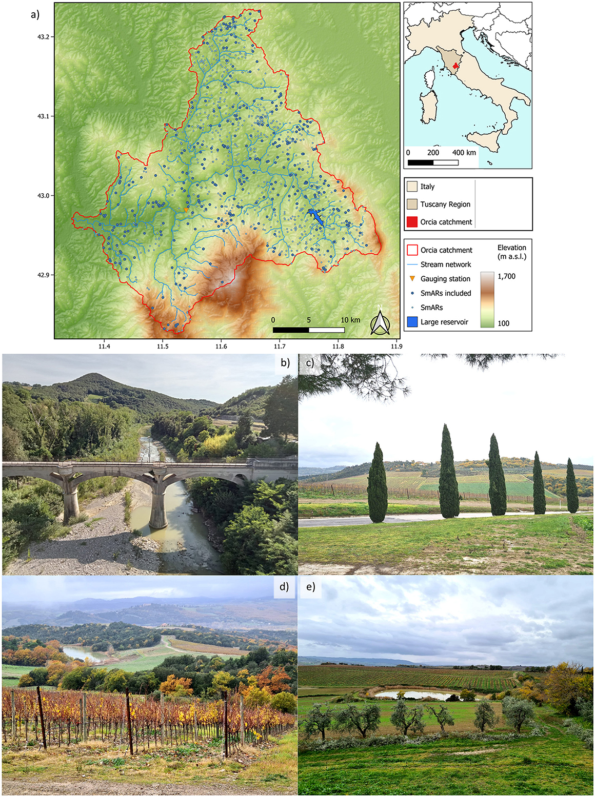
Figure 1. The study area. (a) The Orcia catchment in Italy and Tuscany and the map with the gauging station, the channel network, the planned large dam and the SmARs; (b) the Orcia River at the Monte Amiata Scalo gauging station; (c) typical and characteristic landscape of Val d'Orcia; (d, e) SmARs examples with olive groves and vineyards. Pictures were taken within the AG-WaMED Living Lab activities.
According to the last agricultural censuses, the number of farms that apply irrigation drastically increased in the last decade (ISTAT, 2010, 2020). Elaborations from the latest data available (ISTAT, 2020) show that there are approximately 2,711 ha irrigated in the municipalities of the Orcia catchment. Analyses carried out within the AG-WaMED Project with the WATNEEDS model (Chiarelli et al., 2020) showed how irrigation water requirements remain largely unmet in Val d'Orcia with negative consequences on crop productions (AG-WaMED Project, 2025). Most of the irrigation water is derived from surface water within the farm, natural or artificial SmARs (Figures 1d, e), providing water for 1,990 ha, 73.4% of the total. Arable crops are prevalent in the catchment and tree crops such as olive groves and vineyards are widespread (Figures 1d, e; Napoli et al., 2014; Villani et al., 2024b). According to data for the year 2022 from the ARTEA (2022), the crop area approximates 40,500 ha and the main crops are forage (29%), cereals (22%), other arable crops (16%), vineyards (8%), pastures (7%), and olive groves (6.6%). Winter durum wheat is considered an important quality production and is the most common crop in arable farms (Orlandini et al., 2011). Vineyards are very important for the agricultural economy of the Orcia catchment (Germanier and Moricciani, 2023), with some excellent and well-known certified wines such as the “Brunello di Montalcino DOCG” and the “Orcia DOC”. The vast agricultural areas limit the semi-natural vegetation to a few rare patches of woodland in the tributaries, while forests are prevalent in the higher altitudes of the Monte Amiata (1,738 m a.s.l.).
Vineyards and olive groves were traditionally rainfed in Central Italy and in the Orcia catchment. Now, irrigation is common especially in summer due to increasingly frequent dry periods caused by climate change (Bartolini et al., 2022 and confirmed by local farmers). Future projections in the study area are highly uncertain regarding precipitation (Villani et al., 2024a) and characterized by increased variability and more extreme events such as heavy precipitation and drought periods (Piano Nazionale di Adattamento ai Cambiamenti Climatici - PNACC, 2023). This requires having additional water available to use in summer, and rainwater harvesting is promoted as an interesting solution to provide irrigation water and enhance water security (Degli Innocenti et al., 2025; Villani et al., 2022). A recent drought risk assessment (Villani et al., 2022), in which indicators of hazard, exposure and vulnerability were combined to describe risk in municipalities of Central and Southern Tuscany, found that one of the most representative of the Val d'Orcia—Montalcino—had high exposure but also high adaptive capacity. The high level of exposure is mainly determined by the high value of the agricultural production, while the high adaptive capacity and low vulnerability are mainly due to the relatively young and educated farmers.
The Central Italian landscape is characterized by the presence of thousands of SmARs (Giambastiani et al., 2020; Napoli et al., 2014). In the Tuscany Region, a recent estimate mapped more than 16,000 SmARs (Consorzio LaMMA, 2018). Plenty of them are in the Orcia catchment (Figure 1), and according to the information retrieved from stakeholders and experts when conducting this research, they were mainly realized in the 60s, 70s, and 80s to boost cereal production (Degli Innocenti et al., 2025). It is essential to recognize how many and how small these reservoirs are. As reported in more detail in Forzini et al. (2024), 58% of the SmARs are smaller than 500 m2, and only 29 out of 1,097 SmARs have a surface area larger than 1 ha, with the largest one having a total surface area of 4.54 ha. As economic incentives started to be unrelated to agricultural production through the Common Agricultural Policy decoupling (Brady et al., 2009; Moro and Sckokai, 1999), irrigation ponds were mostly abandoned. However, recently SmARs gained renewed interest in supplying irrigation water for tree crops, especially vineyards, that now benefit from additional water to obtain improved yields, not only in terms of quantity but also of quality. Furthermore, recent drought events sparked interest toward the construction of large dams to ensure water supply in those areas where they are currently missing, such as the Orcia catchment. As a result, abandoned projects are being reconsidered as in the case of the San Piero in Campo dam in the municipality of Radicofani, upper Orcia catchment (Figure 1a), where construction was started in the 80s but never completed.
2.2 The co-modeling approach in the AG-WaMED Living Labs
The study is conducted within the framework of the PRIMA-funded AG-WaMED Project.2 AG-WaMED aims to provide innovative, evidence-based participatory management solutions to water scarcity governance that can be scaled at the Mediterranean level. The Orcia catchment is one of the four rural Living Labs (LLs; Ceseracciu et al., 2023) of the project and has been recently recognized as a water-oriented LL by the Water4All partnership.3 These LLs are animated through the Responsible Research and Innovation (RRI) Roadmap©™, an innovative methodology for transdisciplinary research projects aiming at addressing socio-environmental challenges through co-creation processes involving scientists and practitioners (Theodotou Schneider, 2019). The RRI Roadmap©™ comprises eight milestones4 and steps for identifying common issues, motivating change and transition, co-designing solutions and co-constructing actions (Supplementary Table S1). The RRI Roadmap©™ integrates principles of Design Thinking and Change Management together with the dimensions of Responsible Research and Innovation (RRI) to foster inclusive stakeholder engagement, iterative co-creation, and reflective practice throughout the research and innovation processes. By structuring the co-modeling activities around these principles, the approach ensured that diverse local stakeholders were actively involved in building trust among them, identifying challenges, envisioning sustainable scenarios, and collaboratively co-designing viable solutions. Practitioners in Val d'Orcia LL include farmers, agronomists, small and medium enterprises, representatives of institutions and water management authorities and were engaged through four stakeholders' workshops, site visits and interviews (Table 1). While all milestones are equally important for enabling the co-creation of solutions in the AG-WaMED LLs, two steps are particularly critical for the co-modeling process presented in this study, namely 5. co-design and 6. co-construct. Co-design is the phase in which modeling scope, objectives, and scenarios to be simulated are aligned and refined collaboratively between the AG-WaMED partners and the involved actors. This milestone was the key focus of the first and second participatory workshops, where most of the time was dedicated to discussing the scope of the co-modeling and to defining modeling choices. More specifically, in the first workshop we mainly used the World Cafè participatory methodology, while for the other workshops we used focus-group discussion (Löhr et al., 2020). Co-creation, in the context of the RRI, is the process of creating public policies and services with and for the people (Theodotou Schneider, 2019). In the AG-WaMED Project this step resulted in the development of a shared water management plan (AG-WaMED Project, 2025) that capitalizes on the multidisciplinary analysis carried out during the project, including the hydrological co-modeling in SWAT+, and sets a series of measures to be incrementally implemented to address water scarcity in the Val d'Orcia LL. The third and fourth participatory workshops primarily focused on discussing the draft of the plan, its objectives, proposed measures and strategies for implementation.
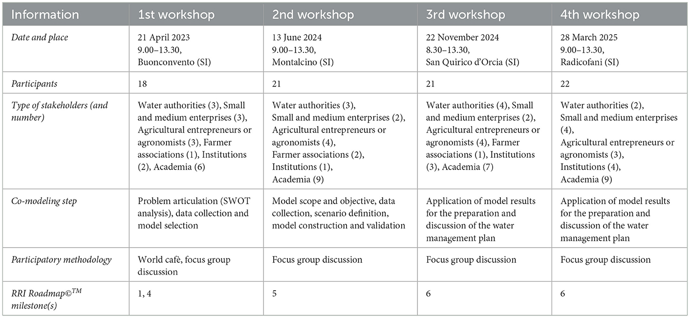
Table 1. Characteristics of the four stakeholders' workshops carried out in the Val d'Orcia Living Lab of the AG-WaMED Project.
2.3 The SWAT+ model set-up, calibration and validation
The SWAT+ model is a restructured version of the widely applied SWAT model (Bieger et al., 2017) which allows for a more flexible and realistic representation of water areas such as SmARs (Mahmoodi et al., 2024) and of their management through the application of decision tables (Arnold et al., 2018; Sánchez-Gómez et al., 2025). In this paper, we use (1) QSWAT+ v2.4.0 for delineating the watershed and creating the Hydrological Response Units (HRUs), (2) SWAT+Editor v2.3.3 to include climate data and modify land use, crop type, management practices, and reservoirs' characteristics, and (3) the SWAT+Toolbox for calibration and validation. The SWAT+ version used is the 60.5.4. The simulation time spans from 2010 to 2020, with 1 year of warm-up that is considered sufficient due to the very low summer flows and the limited importance of groundwater processes. The variables used for calibration and validation are monthly streamflow at the Monte Amiata Scalo gauging station and basin monthly actual evapotranspiration retrieved from the MODIS16A2 remote sensing product (Running et al., 2017). The rating curve for the gauging station is derived through a hydraulic modeling procedure implemented in HEC-RAS since it was not made available by the Hydrological Service of the Tuscany Region. Particularly, a hydraulic model of the river reach containing the hydrometer was developed and steady flow simulations with incremental discharge values were modeled to obtain the hydrometric stage associated with any possible discharge value. The calibration strategy adopted for the SWAT+ model is to first calibrate and validate a simplified model and then transfer the validated parameters to the other models and evaluate the performances. The simplified version of the model has a limited number of HRUs (3,773) and no SmARs; hence, it has a reasonable running time that allows multiple runs for calibration. On the other hand, the models described in Table 2 embrace the complexity of the catchment as much as possible and need a very long simulation time which hampers extensive sensitivity analysis and calibration.
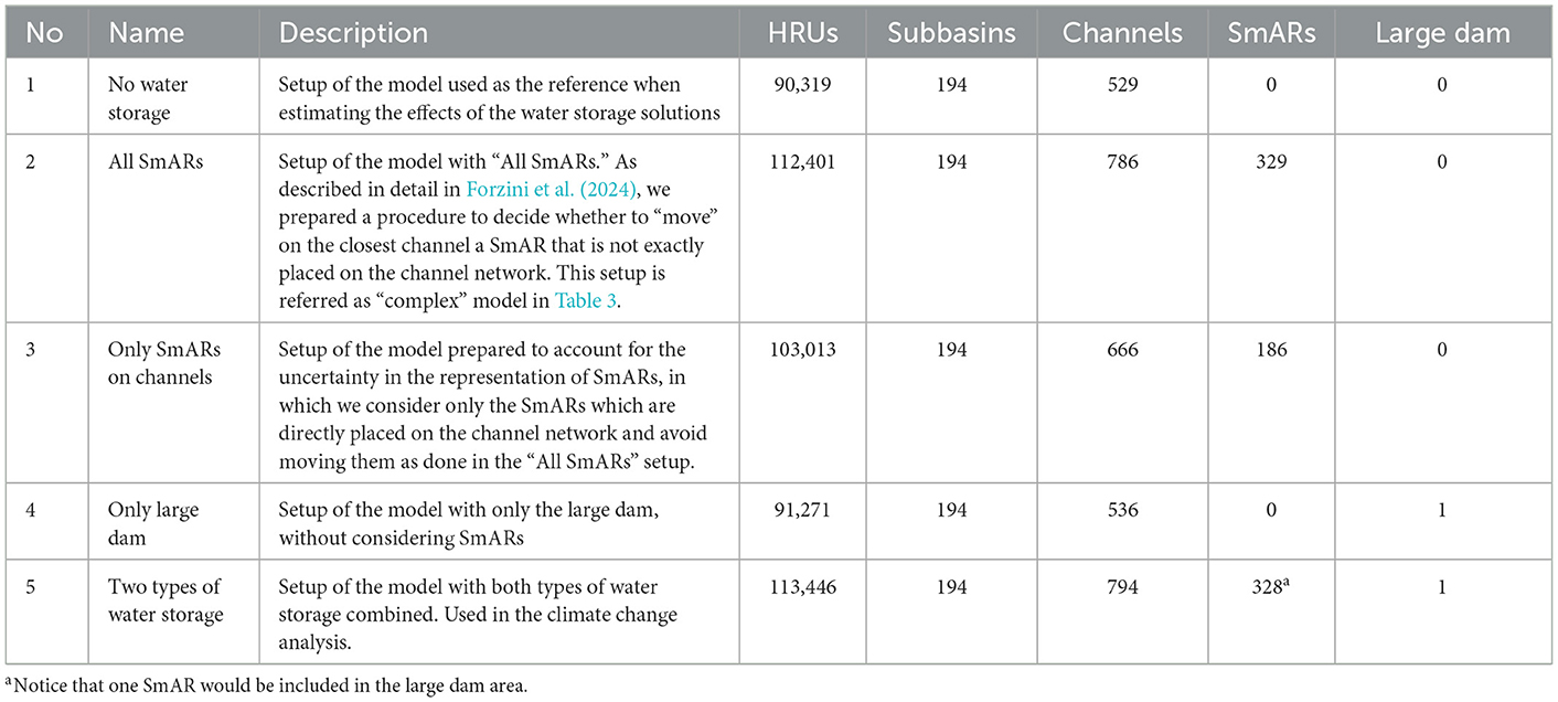
Table 2. Alternative complex model setups with description and characteristics.
An iterative process of multiple calibrations with the simplified model set-up is carried out to find the best period, variables used, relative weights and set of parameters. Since the model simulates evapotranspiration always with more than satisfactory performances, we only calibrate for monthly streamflow. We finally set the calibration period from 2011 to 2016 and the validation period from 2017 to 2020. The two periods are almost equivalent since there is a data gap for streamflow in 2014–2015. The final set of parameters is adapted from a previous study (Villani et al., 2024a) in which a sensitivity analysis yielded cn2—Condition II curve number, esco—Soil evaporation compensation factor, epco—Plant uptake compensation factor, bd—Bulk density and revap_co—Groundwater “revap” coefficient as the most sensitive. Performances of the model are evaluated with the Nash-Sutcliffe Efficiency (NSE), percent bias (PBIAS), Root Mean Square Error—observations standard deviation ratio (RSR), and coefficient of determination (R2) following the criteria of (Moriasi et al. 2007), (2015) reported in Supplementary Table S2. These performance criteria are reported for streamflow, but we also consider them for evapotranspiration as commonly done in similar studies (Bouizrou et al., 2025; Koltsida and Kallioras, 2022; Odusanya et al., 2019). After the calibration and validation of the simplified model, we first transfer the calibrated parameter into the model with all SmARs to check the performances (Setup 2 in Table 2). There, we notice a minor problem in the SWAT+ Toolbox5 which slightly decreases model performances. Hence, we manually modify the parameters to improve the performances of both model setups. The calibrated parameters are then applied to all the model setups of Table 2.
The same input data are used for the SWAT+ setups. The DEM (10 m resolution) and river network provided by the Tuscany Region are used to delineate the watershed with QSWAT+. In the “complex” models, channel and stream thresholds are set at 5 and 200 ha, subbasins with an area < 150 ha are merged as well as short channels with a percentage of the subbasin < 10%. The Corine land use map and soil map elaborated from data of the Tuscany Region (more details in Villani et al., 2024a,b) are used to create HRUs, with three slope classes (0%−5%, 5%−20%, >20%). Olive, grapevine and general agricultural land are split to obtain a more accurate representation of the irrigated and rainfed cropland, in line with the information at the catchment scale retrieved from ISTAT (2010) and ARTEA (2022), respectively.
2.4 The reservoirs' representation in SWAT+
Including many SmARs is challenging in SWAT+ (Dile et al., 2022; Perin et al., 2024). Since most of them are not on the channel network, the automatic inclusion of the reservoirs, which is very convenient when considering large reservoirs such as San Piero in Campo dam, was not possible. The SmARs' inclusion in SWAT+ implies extensive computation time; hence, we opt to prepare a “simplified” model setup for calibration and validation. Here, we modify the land use and include the SmARs as wetlands, following the same approach of the model when including the so-called “playa” lakes. These are nothing more than a different land use that will result in a higher final number of HRUs, but without having a direct impact on flows as they are not included in the stream network. In the other model setups (Table 2), we check all the 1,097 SmARs included in the shapefile provided by the LaMMA consortium and decide whether to consider them or not based on several rules (see Forzini et al., 2024 for more detailed information). Importantly, these rules were shared with the participants of the second participatory workshop, who confirmed the validity of the approach, in light of the limited data being available. Managing the threshold to generate HRUs is a critical choice in the SWAT model setup and depends on the research objectives (Jiang et al., 2021). The very high number of HRUs in the models of Table 2 reflects our need to simulate as many SmARs as possible, but it comes with the drawbacks of having high computation time and little scope for working on spatial units' connections.
SmARs area is calculated from the LaMMA shapefile and the volume is retrieved through the linear equation provided by Giambastiani et al. (2020) valid for small and medium lakes in Tuscany:
The area of the planned San Piero in Campo dam is delineated using the information provided by “Consorzio di Bonifica 6 Toscana Sud” and is 171 ha and the volume is estimated to be 17 million m3.
Multiple parameters are required in SWAT+ to represent the physical and management characteristics of SmARs, such as geometric properties, hydraulic conductivity, and water releases. Despite the involvement of local stakeholders, however, we could not retrieve these data for Val d'Orcia. Only the location and area of the SmARs are provided in the LaMMA shapefile. Additionally, no data about San Piero in Campo dam is available since it is in still in the planning and design stage. We therefore keep all the settings related to reservoirs as simple as possible, mostly using default values (Supplementary Table S3). Similarly, water releases from the reservoirs are simulated using the default decision table, which determines water releases depending on the principal and emergency volumes. Hence, we avoid connecting SmARs with specific HRUs to simulate water withdrawals for irrigation. While this is possible in theory, it is almost impossible in practice due to the very high number of HRUs and, more importantly, would require detailed data on how each reservoir is managed, information that is currently not available. It is also essential to remind that most SmARs in Val d'Orcia are currently abandoned or underutilized (Degli Innocenti et al., 2025) and some of them can be considered multi-purpose, meaning that they are not used only for crop irrigation. Hence, we opt for this simplified management to avoid adding further uncertainty to the analysis due to an oversimplification of the actual management. Regarding the San Piero in Campo dam, we can expect that water demand will drastically increase after its construction, but it is extremely difficult to predict reservoir management since the project is still at the planning and design stage. It shall be noted that even though we do not simulate irrigation water withdrawals from the reservoirs, crop irrigation is represented in the model by adjusting the decision tables that trigger automatic irrigation. In other words, both crop irrigation demand and water availability in the reservoirs are simulated, but not the link between each reservoir and the agricultural field that may benefit from the reservoirs. Because of these simplifications in the representation of reservoirs and in the calibration process, we evaluate the outputs of the SWAT+ model with caution and focus on aggregated reservoir's water balance and on a catchment scale.
2.5 The alternative model setups and their comparison
To carry out the analyses, after calibration and validation, we prepare five alternative complex setups of the SWAT+ model (Table 2). Setup 1 is implemented without any water storage and is used as the baseline for comparison instead of the setup used in the calibration phase that has a very reduced number of HRUs. We then differentiate two setups for considering the SmARs: in Setup 2 we include all of them following the approach explained in detail in Forzini et al. (2024), while in Setup 3, to account for the uncertainty in the representation, we include only the SmARs on the channel network. In addition, we simulate the planned large dam of San Piero in Campo, both alone (Setup 4) and in combination with the SmARs (Setup 5).
The co-modeling process—set up of the baseline model, inclusion of SmARs, calibration and validation, and set up of the alternative water storage scenario models—required much time and multiple adjustments, with increasing risk of unwanted alterations of the model outputs. Hence, multiple checks are performed to ensure that the simulated outputs used for analyses are coherent and that the only difference is the inclusion of different water storage strategies. More in detail, as an initial comparison we check the percentage of land uses and annual average water balance components at the catchment scale, namely precipitation, water yield, percolation, actual and potential evapotranspiration, irrigation, and surface runoff to channels and reservoirs. Then, we check the monthly channel flows at the Monte Amiata Scalo gauging station and the catchment outlet and compare the maximum and minimum values and dates of occurrence as well as the first, second and third quartiles. Then we check the annual average values of the reservoirs in the alternative setups, namely total reservoir area, precipitation, evaporation, seepage, and water stored. We compare these values for the total aggregated reservoirs, the smallest SmAR, the first, second and third quartile SmARs, as well as the largest SmAR (hence excluding the San Piero in Campo dam). After confirming the comparability of the alternative setups, we proceed with analyzing the simulation outputs by plotting the monthly flow duration curves at the catchment outlet and the gauging station. Key reservoir characteristics are also evaluated and compared with estimated values by considering the setup with both water storage strategies. Finally, evaporation and seepage percentage ratios to the total water stored are calculated.
2.6 Climate change scenarios
To investigate future trends in climate and hydrological variables, we rely on five CMIP6 bias-corrected General Circulation Models (GCMs) from the ISIMIP3b climate input data (Lange, 2019, 2021). We download and process daily maximum and minimum temperatures, precipitation, wind speed, relative humidity, and solar radiation, required by SWAT+ for multiple processes and in particular to retrieve potential evapotranspiration through the Penman-Monteith approach, which is the only one that allows consideration of stomatal conductance reduction due to increased CO2 concentration (Neitsch et al., 2011). In SWAT+, CO2 concentration is also used to simulate increased biomass as a consequence of rising CO2 (Neitsch et al., 2011; Villani et al., 2024b). We use them to force the SWAT+ model setup with both water storage strategies—SmARs and large dam—combined. Before using ISIMIP3b climate outputs for future simulations, we compare historical and baseline simulation outputs and finds very accurate annual average precipitation amounts (1.9% changes). While the spatial resolution is not the finest (0.5°) and it might be argued that the use of downscaled Regional Climate Models (RCMs) is preferable, we opt to use these GCMs as they are the most updated climate models from CMIP6, and many other SWAT-related studies applied them in relatively small catchments (e.g., Garcia et al., 2024; Jiménez-Navarro et al., 2021). To limit the simulation runs but at the same time maintain representative scenarios of also the worst future conditions, we select the Shared Socioeconomic Pathway (SSP) 585, the one with an additional radiative forcing of 8.5 W m−2 by the end of the century. Hence, we combine the historical simulations (1981–2014) and the projected future climate under SSP585 (2015–2100) of the five GCMs available (GFDL-ESM4, IPSL-CM6A-LR, MPI-ESM1-2-HR, MRI-ESM2-0, UKESM1-0-LL). Two GCMs (IPSL-CM6A-LR and UKESM1-0-LL) have high climate sensitivity while the other three have low climate sensitivity. Practically, we consider 6 years of warm up and we run separate simulations for the historical period (1981–2014), near (2009–2040), middle (2035–2070), and far (2065–2100) future periods. These periods were used to obtain continuous time series and not for comparing average outputs, for which we preferred selecting a 2.0 °C warming level (WL) and end of the century. We do this also to include in the SWAT+ simulations average CO2 concentration values of 370, 444, 612, and 660 ppm for the respective simulation periods. The values for the historical, near and mid-term future are directly calculated from the ISIMIP3b atmospheric composition inputs (Büchner and Reyer, 2022), while the value for the far future is set to 660 ppm as suggested by Marcinkowski and Piniewski (2024), as the reliability of the equations used in SWAT over this threshold is dubious (Villani et al., 2024a). For each GCM, we then analyze the trend in the whole time series (1987–2100) of the SWAT+ outputs at the catchment scale, focusing on precipitation and average temperature considering both the yearly and dry season average values, with the dry season being from May to September. We also evaluate the trends in the reservoir evaporation, seepage and water stored for the aggregated reservoirs, the planned large dam, the largest SmAR and the aggregated interquartile range (IQR) SmARs (sum of the SmARs with 1st quartile < area < 3rd quartile). The Modified Mann-Kendall test using trend free pre-whitening method as suggested by Yue et al. (2002) is applied through the Python package pyMannKendall (Hussain and Mahmud, 2019) to evaluate the trends and their statistical significance (Bouizrou et al., 2022). Furthermore, we evaluate the absolute and percentage changes in average annual values of the already mentioned reservoirs-related variables and water yield, percolation, irrigation, and actual and potential evapotranspiration of the ensemble means by comparing the reference period (1987–2015) with 2.0 °C WL and end of the century (2071–2100) model outputs. The 2.0 °C WL is selected as it is a key threshold set in the Paris Agreement, while we avoid considering the 1.5 °C WL since under the SSP585 the threshold is crossed too early in the models with high climate sensitivity (Bevacqua et al., 2025). We select a 30-year period centered around the date (James et al., 2017; Ji et al., 2023) in which the 31-year running mean of global mean temperature crosses the threshold as indicated in the ISIMIP3b protocol (Supplementary Table S4).
3 Results
3.1 Co-modeling outputs during the four participatory workshops
In the first participatory workshop, the main water-related challenges and potential solutions were discussed through the World Cafè participatory methodology (Table 1, Figure 2) guided by the RRI Roadmap©™ methodology. Most of the debate revolved around the underutilized SmARs and the planned large dam of San Piero in Campo, which were considered the main solutions to cope with the enhanced water demand caused by climate change. Other technical and non-technical factors associated with the development and management of SmARs and the large dam emerged from the initial brainstorming with stakeholders and these included: lack of coordination among actors involved in water management, legislative and economic barriers for the requalification of existing SmARs and the importance of adopting soil water conservation and infiltration measures to reduce irrigation requirements at the farm and catchment scales (Forzini et al., 2024).
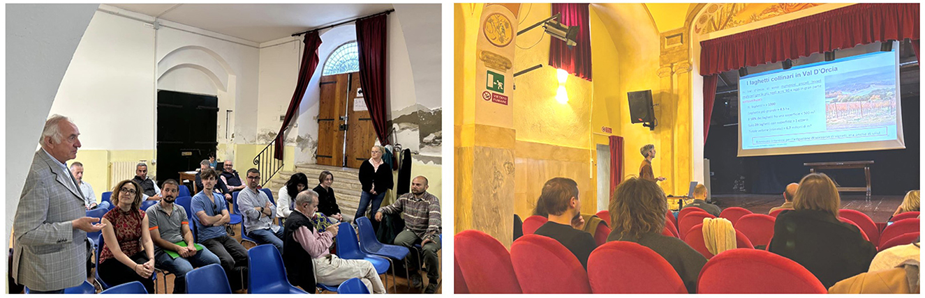
Figure 2. Pictures from the second and fourth participatory workshops.
Based on the first workshop, we prepared the baseline hydrological models. Among them, the SWAT+ model was selected to represent the two water storage strategies due to its flexibility and representativeness of several processes (Bieger et al., 2017; Sánchez-Gómez et al., 2025). The processes and characteristics of the baseline models were presented in the second participatory workshop during which we discussed the model setups and defined the analyses to be performed (Table 1). In particular, the rationale and criteria for the simplified representation of the SmARs in the SWAT+ model were presented, firstly introducing the problem that we cannot directly represent off-stream reservoirs in the model. Afterwards, we showed the results of this representation in terms of numbers and characteristics of the SmARs included in the model with this inclusion/exclusion procedure. While recognizing that the approach used is a simplification, participants agreed that it was representative, even if they stressed the importance of searching for additional input data. In addition, participants confirmed the validity of other types of data used to set up the model, mainly in terms of cropland and irrigated area. Due to a recognized lack of data, a simplified representation of the reservoirs' management was proposed and agreed, as well as the scale of the analysis which was the catchment scale. During the first two workshops, participants expressed their concern about reduced water availability due to climate change and considered as interesting solutions both the planned San Piero in Campo large dam and the SmARs to provide irrigation water. Considering this feedback, we set up the simulations presented in this study considering climate change and alternative SWAT+ setups (Table 2).
In the third and fourth workshops the focus was mostly on social, economic, legislative, and regulatory aspects of restoring existing SmARs and on the construction process. Hence, the hydrological aspects analyzed with SWAT+ were mainly considered as the basis for discussion. By interviewing local experts, the concern of water losses due to evaporation and the potential increase due to climate change emerged, which motivated us to focus on this variable. Additionally, we collected further information about Val d'Orcia that helped in contextualizing the research and improving the quality of the current manuscript, even if not specific modeling aspects were drastically changed. The SWAT+ model used for this study, as well as the other baseline models, in the end contributed to a policy-oriented document to propose an improved water management in the four LLs of the AG-WaMED Project, including the Val d'Orcia LL (AG-WaMED Project, 2025). It is important to remark that the SWAT+ co-modeling is only one of the activities and disciplinary analyses undertaken in the Val d'Orcia LL. While this paper focuses on the assessment of the hydrological conditions of different water storage strategies, further ongoing efforts will show how the multidisciplinary and transdisciplinary research conducted within AG-WaMED is providing innovative management solutions to water scarcity governance.
3.2 The calibration and validation of the co-developed SWAT+ model
After the manual adjustment of the automatically calibrated parameters (Supplementary Table S5), we achieved at least satisfactory performance according to (Moriasi et al. 2007), (2015) for NSE, PBIAS, RSR and R2 with both model setups and both variables (Table 3). It is interesting to underline the fact that the model performances for evapotranspiration were not optimized during calibration, hence we can affirm that the SWAT+ processes and the optimized representation of cropland and irrigation patterns are sufficient to obtain realistic simulations of evapotranspiration at the basin scale in Central Italy (Figure 3b). Additionally, the inclusion of SmARs led to a slight flattening and reduction of peak flows which improved the model performances in terms of PBIAS for monthly streamflow (Figure 3a).
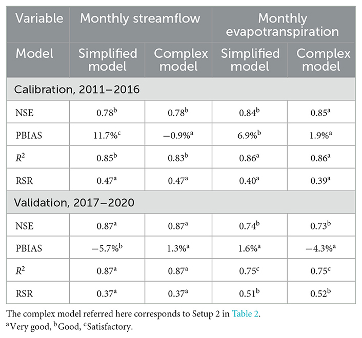
Table 3. The statistics of the SWAT+ model for monthly streamflow and actual evapotranspiration during calibration and validation periods for the simplified and complex models.

Figure 3. (a) Observed and simulated monthly streamflow at Monte Amiata Scalo gauging station. Notice the lack of data from March 2014 to February 2015. (b) Remote sensing and simulated monthly actual evapotranspiration for the whole Orcia catchment.
3.3 The alternative model setups in the baseline simulations
From the flow duration curves prepared considering the monthly time series at the catchment outlets (Supplementary Figure S1) and the gauging station (Figure 4a), it is possible to observe that the differences between the high, average and low monthly flows as simulated by SWAT+ in the five setups are not considerable. We found consistent, similar reductions in average flow at the outlet, compared to the “no water storage” set-up, of −2.5%, −0.4%, −1.7%, and −3.4%, respectively for the “All SmARs,” “SmARs on channels,” “Large dam” and “Both” setups (Figure 4b). Stronger differences are instead observed for the maximum flows, with decreases of −2.2%, −0.9%, −3.6%, and −8.6% for the same setups as compared to the situation without any water storage implemented (Figure 4b). The volume estimated by SWAT+ reasonably corresponds to the volumes estimated, while the average area is consistently lower for all reservoirs (Table 4). Concerning SmARs (see Forzini et al., 2024 for more details), with our representation we were able to include only 358 out of 1,097 (32.6%) SmARs with 80% of the estimated area (127 ha) and volume (5.3 million m3). Hence, the underestimation reported in Table 4 is reduced and we can affirm that SmARs' main characteristics are properly simulated in SWAT+. Given this and the satisfactory simulation of the volume of the planned large dam, since volume is the key variable analyzed, we consider the model usable for the climate change assessment. Since we noticed negligible differences on the water balance of the whole basin and limited impacts among the various reservoirs, we opt to run climate change simulations only considering Setup 5 with both types of water storage combined.
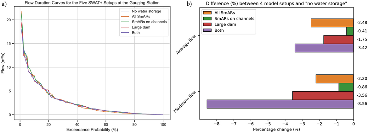
Figure 4. (a) Flow duration curves of the five SWAT+ setups, plotted considering the monthly time series, at the gauging station. (b) The percentage differences in average and maximum flows at the catchment outlet between the four model setups with reservoirs simulated and the “No water storage” setup.
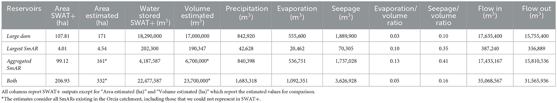
Table 4. Yearly average characteristics considering the baseline simulation (2011–2020) of the large dam, the largest SmAR, the aggregated SmARs and both types of water storage combined considering the outputs of the “Two types of water storage” SWAT+ setup.
3.4 Climate change analyses
Climate change in the Orcia catchment implies significant increasing and decreasing trends in average yearly temperature and precipitation (Supplementary Figure S2, Supplementary Table S6) by 2100, respectively. The ensemble mean of the average temperature rises by 4.9 ± 1.3 °C (34.7%); conversely, precipitation decreases by 156 ± 29 mm (−18.8%). Annual average water yield, percolation, and actual evapotranspiration decrease by 49 ± 16 (−33%), 32 ± 15 (−22%), and 55 ± 15 (−11%) mm respectively, while irrigation and potential evapotranspiration increase by 3.5 ± 0.9 (45.5%) and 149 ± 45 (15%) mm, respectively in the far future. The changes are reduced when considering the 2.0 °C WL.
Future water stored in all reservoirs is expected to decrease by 0.04 ± 0.15 (−0.2%) and 1.48 ± 0.42 (−6.3%) million m3 in the 2.0 °C WL and by the end of the century (Figure 5a), respectively. In the dry season, the relative reduction is estimated as −0.8% and −5.3% (Figure 5b), respectively. Reduced water inflow (−30% by 2100) because of dwindling precipitation is the main driver for this reduction, which sums to the enhanced evaporation from reservoirs triggered by increasing temperatures. The ensemble mean evaporation from all reservoirs increases by 0.07 ± 0.04 (5.9%) and 0.12 ± 0.04 (8.7%) million m3 for the 2.0 °C WL and by 2100, respectively (Figure 6a). Changes in dry season evaporation reach higher percentage changes of 6.2% and 10.1% for the two future scenarios. By the end of the century, the reservoirs' annual average area is reduced by 3.4% for the ensemble mean, with the consequent significant decrease in average seepage from reservoirs. The ensemble mean seepage from all reservoirs decreases by 0.05 ± 0.07 (−1.3%) and 0.37 ± 0.11 (−9.8%) million m3 for the 2.0 °C WL and by 2100, respectively (Figure 6b). Changes in dry season seepage are similar to the yearly values. The average evaporation/volume percentage ratios for all reservoirs shifted from 5.7% in the historical period to 6% and 6.6% under the 2.0 °C WL and by the end of the century, respectively. Instead, seepage/volume percentage ratios for all reservoirs showed a minor increase from 16.1% to 16.9% under the 2.0 °C WL, while a decrease to 15.5% by 2100. As reported in Table 5, the trends calculated over the entire period (1987–2100) are consistent and always statistically significant when considering all the reservoirs aggregated.
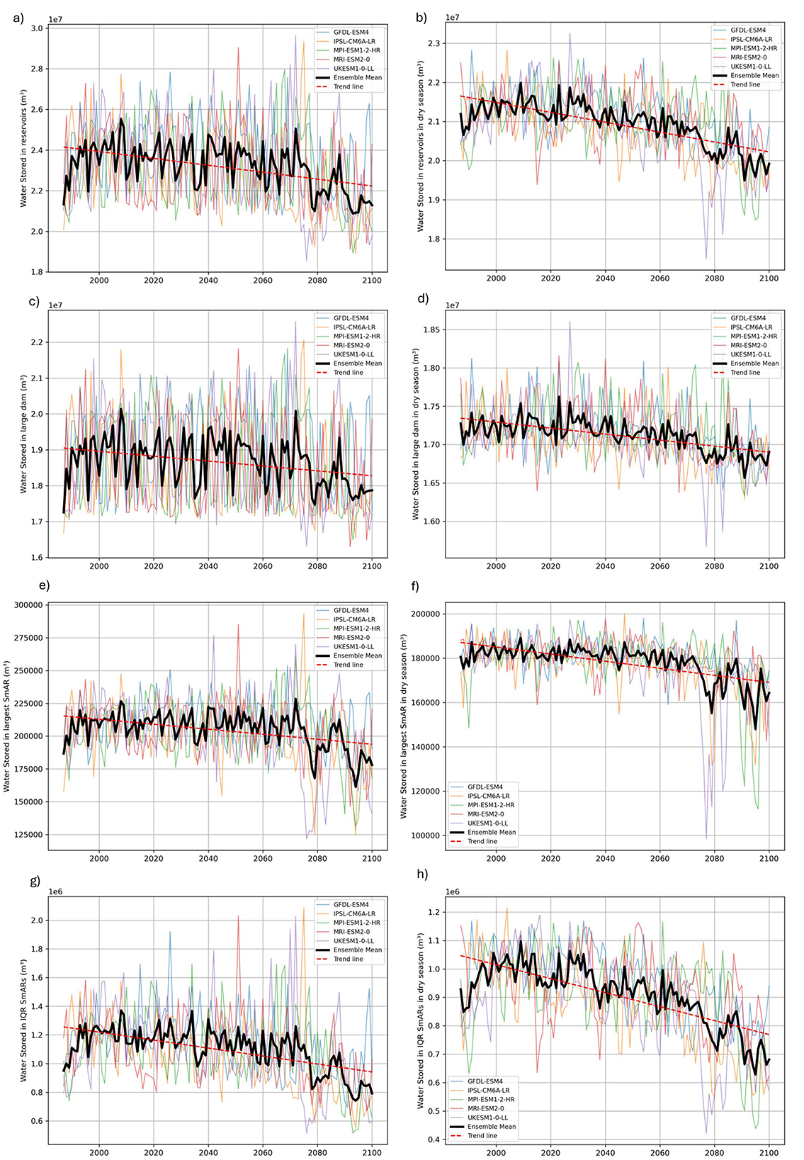
Figure 5. Line plots of yearly (left) and dry season (right) water stored in reservoirs for the five GCMs and the ensemble mean, with the trend line for all reservoirs, large dam, the largest SmAR, and IQR SmARs. (a) Water stored in reservoirs (m3) – Ensemble Mean and Trend Line, (b) Water stored in reservoirs in dry season (m3) – Ensemble Mean and Trend Line, (c) Water stored in large dam (m3) – Ensemble Mean and Trend Line, (d) Water stored in large dam in dry season (m3) – Ensemble Mean and Trend Line, (e) Water stored in largest SmAR (m3) – Ensemble Mean and Trend Line, (f) Water stored in largest SmAR in dry season (m3) – Ensemble Mean and Trend Line, (g) Water stored in IQR SmARs (m3) – Ensemble Mean and Trend Line, (h) Water stored in IQR SmARs in dry season (m3) – Ensemble Mean and Trend Line.
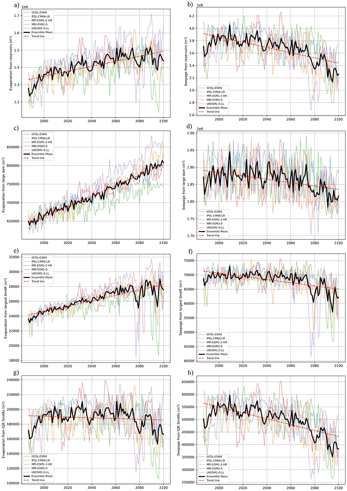
Figure 6. Line plots of yearly evaporation (left) and seapage (right) from all reservoirs, large dam, the largest SmAR and IQR SmARs for the five GCMs and the ensemble mean, with the trend lines. (a) Evaporation from reservoirs (m3) – Ensemble Mean and Trend Line, (b) Seapage from reservoirs (m3) – Ensemble Mean and Trend Line, (c) Evaporation from large dam (m3) – Ensemble Mean and Trend Line, (d) Seapage from large dam (m3) – Ensemble Mean and Trend Line, (e) Evaporation from largest SmAR (m3) – Ensemble Mean and Trend Line, (f) Seapage from largest SmAR (m3) – Ensemble Mean and Trend Line, (g) Evaporation from IQR SmARs (m3) – Ensemble Mean and Trend Line, (h) Seapage from IQR SmARs (m3) – Ensemble Mean and Trend Line.
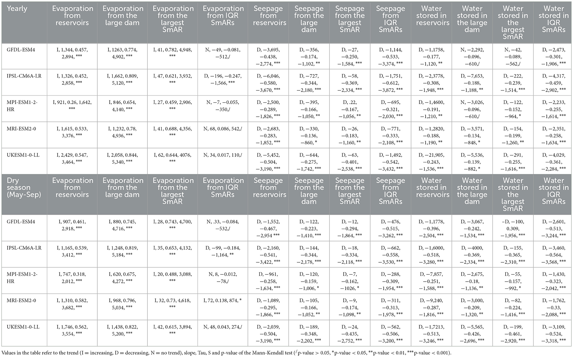
Table 5. Trend of yearly and dry season (from May to September) average temperature, precipitation, evaporation from reservoirs, seepage from reservoirs, and water stored in reservoirs.
If the trends retrieved for the aggregated reservoirs agree in significance and direction for all climate models, this is not valid when considering various water storage strategies such as large dam, largest SmAR and IQR SmARs (Table 5, Figures 5, 6). Under the 2.0 °C WL, the water stored remains almost constant for the large dam (0.1%, Figure 5c), the largest SmAR (0.5%, Figure 5e) and the IQR SmARs (−1.9%, Figure 5g). With increased radiative forcing by the end of the century, the water stored drastically decreases but with very different magnitudes: −3.1% for the large dam (Figure 5c), −8% for the largest SmAR (Figure 5e) and −20.9% for the IQR SmARs (Figure 5g), suggesting higher susceptibility to climate change of smaller reservoirs. Changes in dry season water stored by 2100 are reduced to −2% and −7.8% for the large dam (Figure 5d) and the largest SmAR (Figure 5f), while they are aggravated to −22.2% for IQR SmARs (Figure 5h). The higher decrease is also valid considering the 2.0 °C WL for IQR SmARs (−3.7%), again confirming the higher susceptibility to climate change of smaller reservoirs also in the dry season. The water stored in the large dam and the largest SmAR considering yearly values show a significant decreasing trend for three and four models out of five, respectively (Table 5). On the other hand, decreasing trends are always significant when considering only the dry season or the IQR SmARs (Table 5). Evaporation from the large dam (Figure 6c) and the largest SmAR (Figure 6e) is estimated to increase by 7% and 7.2% under the 2.0 °C WL while by 17.9% and 12.2% by 2100, respectively, with highly significant increasing trends (Table 5). On the other hand, if evaporation from IQR will increase by 4.2% under the 2.0 °C WL, it is projected to decrease by 3.4% by the end of the century (Figure 6g). Table 5 reports the non-significant trends for evaporation from IQR SmARs, except for the decreasing trend detected when considering IPSL-CM6A-LR (for
both yearly and dry season values) and the increasing trend for MRI-ESM2-0 (only with dry season values). Trends and patterns in dry season evaporation from different types of reservoirs do not differ strongly compared to the yearly values, suggesting a similar impact of increasing temperatures during all seasons (Supplementary Figure S3). Seepage changes are more consistent and significantly decreasing for the various storage options both for yearly and dry season values (Table 5). More in detail, seepage is expected to decrease by −0.2%, −0.1%, and −2.7% under the 2.0 °C WL and −2.3%, −7%, and −19.4% by 2100 for the large dam (Figure 6d), the largest SmAR (Figure 6f) and the IQR SmARs (Figure 6h), respectively. The average evaporation/volume percentage ratios show consistent increases for the large dam (from 3.5% to 3.8% and 4.3% in the future scenarios), the largest SmAR (from 11.7% to 12.5% and 14.3%) and for the IQR SmARs (from 15.8% to 16.8% and 19.4%). The changes observed using the dry season values are similar. Driven by increasing temperature, evaporation is therefore expected to be enhanced in the future also for the smallest reservoirs, with the decreasing losses observed for the period 2071–2100 considering the absolute values that are the result of the smaller surface area that limits evaporation losses. Conversely, the average yearly seepage/volume percentage ratios appear to be rather constant around 10%, 33%, and 46% for the large dam, the largest SmAR and the IQR SmARs, respectively. The same ratios for the dry season are reduced to approximately 4%, 15%, and 21%.
4 Discussion
4.1 Large dam vs. SmARs
Our analysis offers useful insights for comparing SmARs and large dams and we are aware that both types of water storage have clear specific pros and cons. Combining alternative types of water storages and promoting good agricultural practices is generally considered as the best solution. Furthermore, the planning and management choices largely depend on the local context. If social, economic and environmental aspects are often the main barriers for reservoir construction, our research suggests that climate change impacts should also be considered in the future water management and planning. More in detail, considering the strongest radiative forcing of SSP585 by the end of the century, the future reservoir water balance alterations, in a Mediterranean climate with projected future decreases in precipitation can be summarized as follows:
• For the large dam (area 171 ha), evaporation losses will strongly increase (≈20%) and coupled with reduced water flows into the dam, will result in a minor water storage decrease (< 5%). Because of the reduction in surface area, seepage losses will slightly decrease (< 5%).
• For most SmARs (area between 0.06 and 0.41 ha), evaporation losses will slightly change (< 5%), but due to the reduction in water flows the future water storage will strongly decrease (≈20%). Due to the reduced area, seepage losses will also strongly decrease (≈20%).
• For the largest SmAR (area 4.54 ha), evaporation losses will increase (12.2%) and with the reduction in water inflows the future water storage will moderately decrease (≈10%). Also for the largest SmAR the seepage losses will decrease (−7%) due to the reduced area, but with lower magnitude compared to the other SmARs.
Furthermore, our results show a reduction of peak flows caused by both SmARs and the large dam by up to 8.6% when simulating both strategies simultaneously (Figure 4b). On the other hand, average river flows are reduced by no more than 3.4% when combining the two types of reservoirs, with the cumulative impact of SmARs that is slightly higher than that of the planned large dam (Figure 4b). While the literature addressing this topic generally agrees that SmARs decrease flows, the range of the magnitude of changes is very wide and depends on multiple characteristics of the reservoirs, climate and catchments but also on the assessment methodology (Habets et al., 2018). Some studies found alarming or at least considerable consequences on flows (Morden et al., 2022; Perin et al., 2024; Yan et al., 2023), while others reported minor cumulative impacts (Dile et al., 2016; Gautam and Corzo, 2023; Liu et al., 2014). Our results are within the lowest ranges reported in the review of Habets et al. (2018) which calculated an average percentage reduction in average flows of 13.4%. Regarding large dams, managing their releases is often suggested as a measure to regulate environmental flows, increase minimum flows during the dry season and reduce drought risk (Ji et al., 2023; Jo et al., 2021; Kim et al., 2021; Lazin et al., 2023). Due to the simplified management considered in our study, we did not notice this effect.
Even if reservoirs are constructed to store water, the unintentional aquifer recharge is an important component of the catchment water balance that cannot be neglected (Escalante et al., 2023; Mozzi et al., 2021; Keller et al., 2000). Even if seepage/volume percentage ratios reported by Keller et al. (2000) are 20% in SmARs and 5% in large reservoirs, which are lower compared to our study (40% for SmARs and 10% for large reservoirs), the output values of our simulations are within the ranges reported by Habets et al. (2018). Nevertheless, more than the absolute values that are difficult to estimate and validate, we focus on the impacts of climate change on future losses. As expected, our analysis shows that the seepage/volume percentage ratios are not affected by climate change and will remain similar. If global warming is maintained below the 2.0 °C threshold, the decrease in seepage losses will be negligible. Conversely, due to reduced inflows and surface area, future seepage losses are expected to drastically decrease by the end of the century even if with very different magnitudes among the different types of reservoirs considered, being the highest for IQR SmARs (−19.4% decrease).
High evaporation losses from SmARs are a consequence of the high surface area-to-volume ratio (Keller et al., 2000). Moreover, great differences exist in the evaporation losses among various climates (Mady et al., 2020). In arid and semi-arid areas evaporation losses from SmARs account for 50% of their volume (Keller et al., 2000), while values around 40% are reported in other parts of the world (Aminzadeh et al., 2024; Mady et al., 2020; Ribeiro Neto et al., 2024). Lower values are instead reported for the evaporation/storage percentage ratios by Zhao et al. (2023) for reservoirs in the United States, between 2.8 and 26%. In line with the values calculated by Zhao et al. (2023), in the Mediterranean climate of Central Italy, the evaporation/volume ratio estimated in our study using the SWAT+ outputs ranges from 3% of the large dam to 10% of the largest SmAR and 13% for the aggregated SmARs (Table 5).
Driven by increasing temperatures, it is not surprising that other studies reported increases in future evaporation from reservoirs. For example, La Fuente et al. (2024) used an ensemble of lake and climate models to analyze 23 European lakes and found increasing evaporation rates up to 62% (average 42%) for the Representative Concentration Pathway 8.5 and summer months. Wang et al. (2018) estimated that global mean evaporation annual lake evaporation will increase by 16% by the end of the century. Similarly, Zhao et al. (2023) predicted increases in reservoir evaporation in the United States of 2%−10% by 2059 and SSP585. Evaporation losses are strongly influenced by surface area (Zhao et al., 2022, 2023), which needs to be considered together with other components of the water balance to fully understand the implications of climate change. The SWAT+ model considers surface area in the calculation of evaporation, and the outputs related to the large dam or the largest SmAR are consistent with values reported by Zhao et al. (2023), who also considered surface area when retrieving evaporation from lakes. Additionally, the interesting pattern reported in Zhao et al. (2023) in which evaporation losses are expected to increase more in those reservoirs with a lower evaporation/volume ratio is observed also in our analysis, so that the increases in future evaporation losses are the highest for the large dam (historical evaporation/volume percentage ratio of 3.5%), followed by the largest SmAR (historical evaporation/volume percentage ratio of 11.7%). Instead, opposite outcomes are found for the smaller SmARs (the IQR SmARs in our research), even if the changes in the evaporation/volume ratios showed similar increases to the other larger reservoirs. More precisely, decreasing evaporation losses are observed from the IQR SmARs because of the lower surface area resulting from reduced precipitation, runoff and reservoir inflows. Hence, to correctly estimate future water losses in all reservoirs—but even more in SmARs—it is fundamental to consider surface area changes. If increased evaporation rates are a clear negative effect of climate change for all reservoirs, this seems to be affecting more severely the larger dams with a low evaporation/volume ratio. Further research is required to better understand these dynamics with a higher number of reservoirs of intermediate sizes, in other climates and with different changes caused by global warming. Generally, we can state that the increase in evaporation losses (the real water loss from the catchment) is balanced by the reduction in seepage losses (leading to a lower—beneficial—aquifer recharge).
4.2 Co-creation, further research, and limitations
While we consider our results useful to inform water managers and planners and to provide insights about the dynamics of large dams and SmARs in current and future climates, we recognize that our modeling approach has some limitations. First, it is important to underline that the strong reductions in water stored especially in the smallest SmARs were found by the end of the century under the SSP585 scenario, which assumes no mitigation strategies to reduce greenhouse gas emissions. The uncertainty embedded in the climate models and RCPs (or SSPs) largely influence the results as in Rodrigues et al. (2023), that in Brazil found significantly increasing trends in annual evaporation rates only when considering one climate model. Additionally, the results reported consider a constant hydraulic conductivity of the bottom of the reservoirs of 0.2 mm/hour for all types of reservoirs. This is a simplification that might have led to an overestimation of the seepage losses since, the smaller the SmAR, the easier and the more common it is to avoid percolation losses by covering the bottom of the reservoirs with an impermeable layer. However, most SmARs in the Orcia catchment are generally at least 40 years old and mostly abandoned, hence it is reasonable to assume infiltration from the bottom. While we argue that the seepage outputs expressed in relative terms are very interesting and realistic, the absolute outputs of the SWAT+ model are prone to uncertainties given the lack of precise input data. Furthermore, we did not simulate adaptation strategies or techniques aimed at reducing evaporation and seepage losses (e.g., Mady et al., 2020), a topic which surely requires further investigation. Another limitation of the study refers to the simplified management that does not consider water withdrawals for irrigation or other uses. The expected increases in irrigation, as also simulated in our SWAT+ model, will probably lead to enhanced water withdrawals in the future. Without considering the water withdrawals, our reservoir volume reductions are probably underestimated. As already mentioned in the methodology section, we opted for a simplified representation given the lack of data to avoid adding further uncertainty. Furthermore, progressive siltation of the reservoirs should be investigated. The filling phase of large dams can have significant drawbacks (da Silva et al., 2020; Zaniolo et al., 2021) that were not considered in this study. For a more detailed analysis, using higher resolution climate projections tailored to the study area would also be another improvement to the adopted methodology. Finally, improvements in the model set up and calibration and validation could be considered in future studies, for example by using a more sophisticated equation to estimate water storage volumes of SmARs and an improved rating curve. Future research should investigate these and many other aspects to shed light on their impacts on future reservoir balance components and water storage of alternative strategies.
If the co-modeling approach is a strength of our study, it also brings additional challenges compared to pure hydrological assessments. More specifically, the work behind this study was developed over more than two years and multiple changes were applied to the methodology, objectives and model setups. While this is positive since we considered as much as possible the feedback from participants of the AG-WaMED workshops, modifying a complex model such as SWAT+ over a long period is difficult and time-consuming since a slight change can have potentially unspotted implications on different outputs. We argue that the benefits of co-modeling—in terms of shared assumptions, improved representation of specific processes and enhanced applicability—overcome the downsides compared to only academic hydrological studies. However, when it comes to model selection in a co-modeling approach, it is extremely important to evaluate accurately if the complexity of the model chosen is necessary to answer the research questions (De Angeli et al., 2025; Rangecroft et al., 2018). We involved stakeholders both directly and indirectly throughout various phases of the co-modeling process, although their contributions were more significant during the initial stages of the analysis. They contributed to the selection of the water storage strategies to be simulated, suggesting the climate change analysis and the focus on evaporation, providing and validating the input data used and the representation of the SmARs. Furthermore, they provided feedback on how the hydrological assessment can support the social and political discussion on water resources management at the local level. Practically, the outputs of this study were integrated in a watershed management plan for the Val d'Orcia, a strategic document that showcase the role of SmARs in the local agricultural system and that outlines a series of measures to promote their use (AG-WaMED Project, 2025). Here, we limited our analysis to hydrological aspects, while we expect to discuss key physical, economic, social, legislative, and regulatory aspects in future outputs of the AG-WaMED Project. Despite the discussed limitations, this study offers valuable insights by applying a semi-distributed, process-based hydrological model at a very high level of detail (=100,000 HRUs). Importantly, our methodology is based on a co-modeling approach in which the assumptions and decisions were largely shared with local actors participating in the LL activities. Through the systematic incorporation of the eight RRI Roadmap©™ milestones, the co-modeling activities in Val d'Orcia exemplified how structured, participatory methodologies can successfully bridge scientific knowledge and societal needs. Consequently, the use of the RRI Roadmap©™ significantly improved the acceptance, feasibility, and legitimacy of the research outputs, effectively responding to both local concerns and broader sustainability objectives.
In Val d'Orcia, critical decisions about water management must be made in the near future. A detailed analysis of future water demand would be very useful to understand whether current water sources are enough and to measure how much more might be needed. The initial analysis conducted in AG-WaMED showed that water available in SmARs could cover a large share of current irrigation water requirements, even if great barriers exist (AG-WaMED Project, 2025). While this study focused exclusively on expanding water supply, a range of complementary strategies should also be considered and increasingly implemented to enhance water use efficiency and productivity, ranging from field to catchment scales.
5 Conclusions
In this study, we applied the process-based, semi-distributed SWAT+ model to simulate past and future reservoir dynamics in a representative Mediterranean catchment in Central Italy. We take advantage of the flexibility of the model to simulate processes at a very high detail and various types of reservoirs, including very small ones. Concurrently, we applied the RRI Roadmap©™ to guide and facilitate the active involvement of local actors to engage and gain mutual confidence to participate in the activities of the AG-WaMED Italian living lab; the co-modeling approach helped in justifying the modeling choices and generally improved the research quality and its potential actualization. Climate change will affect future water storage in all types of reservoirs, even if the negative impacts are strongly mitigated if we remain below the 2.0 °C warming threshold. Evaporation losses increase seem to be a major concern for those reservoirs with low evaporation/volume ratios, namely the largest ones, even if the evaporation losses remain a lower share of their volume compared to smaller ones. Smaller reservoirs are found to be very susceptible to climate change and in particular to reduced runoff. Aquifer recharge shrinking from reservoirs is another negative indirect consequence of climate change and the reduced area of the reservoirs. While multiple climate change challenges emerged for the different reservoir categories, we conclude by recommending the integration of alternative, complementary, context-specific water storage strategies to guarantee water security by taking advantage of their different characteristics—as already suggested in similar research in other parts of the world (e.g., Ebrahim et al., 2024; Keller et al., 2000; Meira Neto et al., 2024).
Data availability statement
Input and output data used to carry out this research are available on the AG-WaMED PRIMA Project dataset available on the Zenodo platform. https://doi.org/10.5281/zenodo.17011793. Other data referenced in the study are available on request to the authors.
Ethics statement
Written informed consent was obtained from the individual(s) for the publication of any potentially identifiable images or data included in this article.
Author contributions
LV: Conceptualization, Investigation, Methodology, Writing – original draft, Writing – review & editing. GC: Conceptualization, Investigation, Methodology, Writing – original draft, Supervision, Funding acquisition, Project administration, Writing – review & editing. EF: Investigation, Methodology, Writing – review & editing. LP: Writing – original draft, Writing – review & editing. EL: Investigation, Writing – original draft, Writing – review & editing. IB: Methodology, Writing – review & editing. ML: Investigation, Methodology, Writing – original draft, Writing – review & editing. GB: Investigation, Writing – review & editing. AG: Investigation, Writing – review & editing. DDC: Methodology, Writing – review & editing. XTS: Methodology, Writing – review & editing. TP: Conceptualization, Investigation, Supervision, Funding acquisition, Writing – review & editing. EC: Supervision, Funding acquisition, Writing – review & editing. EB: Supervision, Funding acquisition, Project administration, Writing – review & editing.
Funding
The author(s) declare that financial support was received for the research and/or publication of this article. This research was carried out within the AG-WaMED Project (CUP B53C22004860003), funded by the Partnership for Research and Innovation in the Mediterranean Area Programme (PRIMA), an Art.185 initiative supported and funded under Horizon 2020, the European Union's Framework Programme for Research and Innovation, Grant Agreement Number [Italy: 391 del 20/10/2022, Egypt: 45878, Tunisia: 0005874-004-18-2022-3, Greece: ΓΓP21-0474657, Spain: PCI2022-132929, Algeria: N° 04/PRIMA_section 2/2021] and the RETURN Extended Partnership and received funding from the European Union Next-GenerationEU (National Recovery and Resilience Plan – NRRP, Mission 4, Component 2, Investment 1.3 – D.D. 1243 2/8/2022, PE0000005).
Acknowledgments
We are extremely grateful to all the participants of the AG-WaMED Italian Living Lab - Val d'Orcia who contributed to its activities and research outputs and in particular the municipalities of Montalcino, San Quirico d'Orcia, and Radicofani for the support in the organization of the participatory workshops. We also acknowledge the LaMMA consortium for providing the detailed shapefile with the SmARs of Val d'Orcia (Consorzio LaMMA, 2018).
Conflict of interest
XT was employed by XPRO Consulting Limited.
The remaining authors declare that the research was conducted in the absence of any commercial or financial relationships that could be construed as a potential conflict of interest.
The author(s) declared that they were an editorial board member of Frontiers, at the time of submission. This had no impact on the peer review process and the final decision.
Generative AI statement
The author(s) declare that no Gen AI was used in the creation of this manuscript.
Any alternative text (alt text) provided alongside figures in this article has been generated by Frontiers with the support of artificial intelligence and reasonable efforts have been made to ensure accuracy, including review by the authors wherever possible. If you identify any issues, please contact us.
Publisher's note
All claims expressed in this article are solely those of the authors and do not necessarily represent those of their affiliated organizations, or those of the publisher, the editors and the reviewers. Any product that may be evaluated in this article, or claim that may be made by its manufacturer, is not guaranteed or endorsed by the publisher.
Author disclaimer
Views and opinions expressed are however those of the author(s) only and do not necessarily reflect those of the European Union or PRIMA Neither the European Union nor the granting authority can be held responsible for them. The RRI Roadmap©TM methodology and its tools or portions of it are the ownership of XPRO Consulting Limited, Cyprus. All Rights Reserved. The RRI Roadmap©TM may be licensed.
Supplementary material
The Supplementary Material for this article can be found online at: https://www.frontiersin.org/articles/10.3389/frwa.2025.1673203/full#supplementary-material
Footnotes
1. ^Considering only years without missing values.
2. ^agwamed.eu
3. ^watereurope.eu/woll/ag-wamed-val-dorcia-living-lab/
4. ^1: Identify the needs of the challenge; 2: Motivate Change; 3: Engage all stakeholders; 4: Ideate and Frame; 5: Co-Design; 6: Co-Construct; 7: Measure and Adjust; 8: Intensify the effort to reach the common vision.
5. ^Comparing the performances calculated with the SWAT+ Toolbox and independently, we noticed slightly different values. A possible explanation could be the problem in reading the correct channel when including floodplains: https://groups.google.com/g/swatplus/c/WAsnHOH3pbE/m/bm1cRv_JAQAJ?pli=1.
References
AG-WaMED Project (2025). Integrated Watershed Management Plan – Val d'Orcia living lab. Available online at: https://agwamed.eu/wp-content/uploads/2025/07/ITA_in-English_AG-WaMED-IWMP-Italy-Final-Version.pdf (Accessed October 8, 2025).
Ahmad, M. J., Cho, G., and Choi, K. S. (2022). Historical climate change impacts on the water balance and storage capacity of agricultural reservoirs in small ungauged watersheds. J. Hydrol. Reg. Stud. 41:101114. doi: 10.1016/j.ejrh.2022.101114
Akbas, A., Freer, J., Ozdemir, H., Bates, P. D., and Turp, M. T. (2020). What about reservoirs? Questioning anthropogenic and climatic interferences on water availability. Hydrol. Process. 34, 5441–5455. doi: 10.1002/hyp.13960
Alba, V., Russi, A., Caputo, A. R., and Gentilesco, G. (2024). Climate change and viticulture in Italy: historical trends and future scenarios. Atmosphere 15:885. doi: 10.3390/atmos15080885
Aminzadeh, M., Friedrich, N., Narayanaswamy, S., Madani, K., and Shokri, N. (2024). Evaporation loss from small agricultural reservoirs in a warming climate: an overlooked component of water accounting. Earth's Future 12:e2023EF004050. doi: 10.1029/2023EF004050
Amorocho-Daza, H., Sušnik, J., Van Der Zaag, P., and Slinger, J. H. (2025). A model-based policy analysis framework for social-ecological systems: integrating uncertainty and participation in system dynamics modelling. Ecol. Modell. 499:110943. doi: 10.1016/j.ecolmodel.2024.110943
Andráško, I., Duží, B., and Martinát, S. (2024). A dam or a polder? Stakeholders' dispute over the “right” flood-protection measure in the Czech Republic. Ambio 53, 1505–1521. doi: 10.1007/s13280-024-02022-7
Arheimer, B., Cudennec, C., Castellarin, A., Grimaldi, S., Heal, K. V., Lupton, C., et al. (2024). The IAHS Science for Solutions decade, with Hydrology Engaging Local People IN one Global world (HELPING). Hydrol. Sci. J. 69, 1417–1435. doi: 10.1080/02626667.2024.2355202
Arnold, J. G., Bieger, K., White, M. J., Srinivasan, R., Dunbar, J. A., and Allen, P. M. (2018). Use of decision tables to simulate management in SWAT+. Water 10:713.
Arnold, J. G., Srinivasan, R., Muttiah, R. S., and Williams, J. R. (1998). Large area hydrologic modeling and assessment part I: model development 1. J. Am. Water Resources Assoc. 34, 73–89. doi: 10.1111/j.1752-1688.1998.tb05961.x
ARTEA (2022). ARTEA Piani Colturali Grafici 2022. Available online at: https://dati.toscana.it/dataset/artea-piani-colturali-grafici-2022 (Accessed February 7, 2024).
Bartolini, G., Betti, G., Gozzini, B., Iannuccilli, M., Magno, R., Messeri, G., et al. (2022). Spatial and temporal changes in dry spells in a Mediterranean area: Tuscany (central Italy), 1955–2017. Int. J. Climatol. 42, 1670–1691. doi: 10.1002/joc.7327
Basco-Carrera, L., Warren, A., van Beek, E., Jonoski, A., and Giardino, A. (2017). Collaborative modelling or participatory modelling? A framework for water resources management. Environ. Modell. Softw. 91, 95–110. doi: 10.1016/j.envsoft.2017.01.014
Bellini, E., Martin, R., Argenti, G., Staglianò, N., Costafreda-Aumedes, S., Dibari, C., et al. (2023). Opportunities for adaptation to climate change of extensively grazed pastures in the Central Apennines (Italy). Land. 12:351. doi: 10.3390/land12020351
Berti Suman, A., García-Herrero, L., Lavrnić, S., Sole, M. C., Toscano, A., and Vittuari, M. (2023). The advent of EU water reuse regulation in the Mediterranean region: policy and legislative adaptation to address non-conventional water resources utilization in agriculture. Water Int. 48, 839–860. doi: 10.1080/02508060.2023.2277619
Bevacqua, E., Schleussner, C. F., and Zscheischler, J. (2025). A year above 1.5 °C signals that earth is most probably within the 20-year period that will reach the Paris Agreement limit. Nat. Clim. Change 15, 262–265. doi: 10.5194/egusphere-egu25-2849
Bieger, K., Arnold, J. G., Rathjens, H., White, M. J., Bosch, D. D., Allen, P. M., et al. (2017). Introduction to SWAT+, a completely restructured version of the soil and water assessment tool. JAWRA J. Am. Water Resour. Assoc. 53, 115–130. doi: 10.1111/1752-1688.12482
Blanc, E., and Strobl, E. (2014). Is small better? A comparison of the effect of large and small dams on cropland productivity in South Africa. World Bank Econ. Rev. 28, 545–576. doi: 10.1093/wber/lht026
Bouizrou, I., Aqnouy, M., and Bouadila, A. (2022). Spatio-temporal analysis of trends and variability in precipitation across Morocco: comparative analysis of recent and old non-parametric methods. J. Afr. Earth Sci. 196:104691. doi: 10.1016/j.jafrearsci.2022.104691
Bouizrou, I., Castelli, G., Cabrera, G. A., Villani, L., Solomos, S., Maneas, G., et al. (2025). The potential of novel remote sensing evapotranspiration data and global soil maps for SWAT+ agro-hydrological modeling in data-scarce regions of the North Mediterranean. Agri. Water Manage. 319, 109761.
Brady, M., Kellermann, K., Sahrbacher, C., and Jelinek, L. (2009). Impacts of decoupled agricultural support on farm structure, biodiversity and landscape mosaic: some EU results. J. Agric. Econ. 60, 563–585. doi: 10.1111/j.1477-9552.2009.00216.x
Büchner, M., and Reyer, C. P. O. (2022). ISIMIP3b atmospheric composition input data (v1.1). ISIMIP Repository.
Casadei, S., Di Francesco, S., Giannone, F., and Pierleoni, A. (2019). Small reservoirs for a sustainable water resources management. Adv. Geosci. 49, 165–174. doi: 10.5194/adgeo-49-165-2019
Ceseracciu, C., Branca, G., Deriu, R., and Roggero, P. P. (2023). Using the right words or using the words right? Re-conceptualising living labs for systemic innovation in socio-ecological systems. J. Rural Stud. 104:103154. doi: 10.1016/j.jrurstud.2023.103154
Chiarelli, D. D., Passera, C., Rosa, L., Davis, K. F., D'Odorico, P., and Rulli, M. C. (2020). The green and blue crop water requirement WATNEEDS model and its global gridded outputs. Sci. Data 7:273. doi: 10.1038/s41597-020-00612-0
Colombo, P., Neto, G. R., Costa, A. C., Mamede, G. L., and Van Oel, P. R. (2024). Modeling the influence of small reservoirs on hydrological drought propagation in space and time. J. Hydrol. 629:130640. doi: 10.1016/j.jhydrol.2024.130640
Consorzio LaMMA (2018). Catasto Invasi Regione Toscana. Available online at: https://geoportale.lamma.rete.toscana.it/difesa_suolo/#/viewer/372 (Accessed May 5, 2025).
da Silva, G. C. X., Medeiros de Abreu, C. H., Ward, N. D., Belúcio, L. P., Brito, D. C., Cunha, H. F. A., et al. (2020). Environmental impacts of dam reservoir filling in the East Amazon. Front. Water 2:11. doi: 10.3389/frwa.2020.00011
De Angeli, S., Villani, L., Castelli, G., Rusca, M., Boni, G., Bresci, E., et al. (2025). Invited perspectives: advancing knowledge co-creation in drought impact studies. Nat. Hazards Earth Syst. Sci. 25, 2571–2589. doi: 10.5194/nhess-25-2571-2025
de Araújo, J. C., and Bronstert, A. (2015). A method to assess hydrological drought in semi-arid environments and its application to the Jaguaribe River basin, Brazil. Water Int. 41, 213–230. doi: 10.1080/02508060.2015.1113077
Degli Innocenti, E., Castelli, G., Pozzolini, S., Preti, F., Bresci, E., and Caporali, E. (2025). Modelling land use changes impacts on the silting of small agricultural water harvesting reservoirs. Int. Soil Water Conserv. Res. 13, 422–435. doi: 10.1016/j.iswcr.2025.02.001
Di Francesco, S., Casadei, S., Di Mella, I., and Giannone, F. (2022). The role of small reservoirs in a water scarcity scenario: a computational approach. Water Resources Manag. 36, 875–889. doi: 10.1007/s11269-021-03052-6
Dibari, C., Argenti, G., Catolfi, F., Moriondo, M., Staglianò, N., and Bindi, M. (2015). Pastoral suitability driven by future climate change along the Apennines. Ital. J. Agron. 10:659. doi: 10.4081/ija.2015.659
Dile, Y. T., Karlberg, L., Daggupati, P., Srinivasan, R., Wiberg, D., and Rockström, J. (2016). Assessing the implications of water harvesting intensification on upstream–downstream ecosystem services: a case study in the Lake Tana basin. Sci. Total Environ. 542, 22–35. doi: 10.1016/j.scitotenv.2015.10.065
Ebrahim, G. Y., Lautze, J. F., McCartney, M., Matheswaran, K., Nyikadzino, B., and Tafesse, N. T. (2024). Beyond dams: assessing integrated water storage in the Shashe catchment, Limpopo River Basin. J. Hydrol. Regional Stud. 55:101913. doi: 10.1016/j.ejrh.2024.101913
Escalante, E. F., Casas, J. D. H., Per, C. M. D. G., Vera, M. D. M., and Valverde, C. M. (2023). Unintentional recharge of aquifers from small dams and dykes in Spain: a GIS-based approach to determine a fractional volume. Earth 4, 584–605. doi: 10.3390/earth4030031
Falconi, S. M., and Palmer, R. N. (2017). An interdisciplinary framework for participatory modeling design and evaluation—What makes models effective participatory decision tools? Water Resources Res. 53, 1625–1645. doi: 10.1002/2016WR019373
Forzini, E., Villani, L., Castelli, G., and Bresci, E. (2024). “Participatory modeling of small agricultural reservoirs in the Orcia watershed, Italy,” in Biosystems Engineering Promoting Resilience to Climate Change - AIIA 2024 - Mid Term, in L. Sartori, P. Tarolli, L. L. Guerrini, G. Zuecco, and A. Pezzuolo (Springer, Cham), 107–114.
Fraga, H., García de Cortázar Atauri, I., Malheiro, A. C., and Santos, J. A. (2016). Modelling climate change impacts on viticultural yield, phenology and stress conditions in Europe. Global Change Biol. 22, 3774–3788. doi: 10.1111/gcb.13382
Fraga, H., Moriondo, M., Leolini, L., and Santos, J. A. (2020). Mediterranean olive orchards under climate change: a review of future impacts and adaptation strategies. Agronomy 11:56. doi: 10.3390/agronomy11010056
Fresta, M. (2011). La Val d'Orcia: ovvero l'invenzione di un paesaggio tipico toscano. Lares 77, 205–218.
Garcia, X., Estrada, L., Llorente, O., and Acuña, V. (2024). Assessing small hydropower viability in water-scarce regions: environmental flow and climate change impacts using a SWAT+ based tool. Environ. Sci. Europe 36:126. doi: 10.1186/s12302-024-00938-1
Gautam, K., and Corzo, G. (2023). Evaluating the impact of ponds on flood and drought mitigation in the Bagmati River Basin, Nepal. Hydrol. Res. 54, 1163–1180. doi: 10.2166/nh.2023.050
Georgopoulou, E., Gakis, N., Voloudakis, D., Daskalakis, M., Sarafidis, Y., Lalas, D. P., et al. (2024). Effectiveness of options for the adaptation of crop farming to climate change in a country of the European South. Agriculture 14:1814. doi: 10.3390/agriculture14101814
Germanier, R., and Moricciani, N. (2023). Perceiving and adapting to climate change: perspectives of Tuscan wine-producing agritourism owners. Sustainability 15:2100. doi: 10.3390/su15032100
Giambastiani, Y., Giusti, R., Cecchi, S., Palomba, F., Manetti, F., Romanelli, S., et al. (2020). Volume estimation of lakes and reservoirs based on aquatic drone surveys: the case study of Tuscany, Italy. J. Water Land Dev. 46, 84–96. doi: 10.24425/jwld.2020.134200
Giambastiani, Y., Giusti, R., Gardin, L., Cecchi, S., Iannuccilli, M., Romanelli, S., et al. (2022). Assessing soil erosion by monitoring hilly lakes silting. Sustainability 14:5649. doi: 10.3390/su14095649
Habets, F., Molénat, J., Carluer, N., Douez, O., and Leenhardt, D. (2018). The cumulative impacts of small reservoirs on hydrology: a review. Sci. Total Environ. 643, 850–867. doi: 10.1016/j.scitotenv.2018.06.188
Hare, M. (2011). Forms of participatory modelling and its potential for widespread adoption in the water sector. Environ. Policy Gov. 21, 386–402. doi: 10.1002/eet.590
Holgerson, M., and Raymond, P. (2016). Large contribution to inland water CO2 and CH4 emissions from very small ponds. Nat. Geosci. 9, 222–226. doi: 10.1038/ngeo2654
Huber, A., Gorostiza, S., Kotsila, P., Beltrán, M. J., and Armiero, M. (2017). Beyond “socially constructed” disasters: re-politicizing the debate on large dams through a political ecology of risk. Capital. Nat. Soc. 28, 48–68. doi: 10.1080/10455752.2016.1225222
Hussain, M., and Mahmud, I. (2019). pyMannKendall: a python package for non parametric Mann Kendall family of trend tests. J. Open Source Softw. 4:1556. doi: 10.21105/joss.01556
ISMEA (2024). Olio d'oliva, scheda di settore. Available online at: https://www.ismeamercati.it/olio-oliva (Accessed May 1, 2025).
ISMEA (2025). L'Italia del vino. Available online at: https://www.ismeamercati.it/vino (Accessed May 1, 2025).
ISTAT (2010). Sixth agricultural census. Available online at: http://dati-censimentoagricoltura.istat.it/Index.aspx (Accessed February 7, 2024).
ISTAT (2020). Seventh agricultural census. Available online at: https://esploradati.istat.it/databrowser/#/it/censimentoagricoltura/categories (Accessed December 10, 2024).
James, R., Washington, R., Schleussner, C. F., Rogelj, J., and Conway, D. (2017). Characterizing half-a-degree difference: a review of methods for identifying regional climate responses to global warming targets. Wiley Interdiscip. Rev. Clim. Change 8:e457. doi: 10.1002/wcc.457
Ji, P., Yuan, X., and Jiao, Y. (2023). Future hydrological drought changes over the upper Yellow River basin: the role of climate change, land cover change and reservoir operation. J. Hydrol. 617:129128. doi: 10.1016/j.jhydrol.2023.129128
Jiang, L., Zhu, J., Chen, W., Hu, Y., Yao, J., Yu, S., et al. (2021). Identification of suitable hydrologic response unit thresholds for soil and water assessment tool streamflow modelling. Chin. Geogr. Sci. 31, 696–710. doi: 10.1007/s11769-021-1218-4
Jiménez-Navarro, I. C., Jimeno-Sáez, P., López-Ballesteros, A., Pérez-Sánchez, J., and Senent-Aparicio, J. (2021). Impact of climate change on the hydrology of the forested watershed that drains to Lake Erken in Sweden: an analysis using SWAT+ and CMIP6 scenarios. Forests 12:1803. doi: 10.3390/f12121803
Jo, Y. J., Song, J. H., Her, Y., Provolo, G., Beom, J., Jeung, M., et al. (2021). Assessing the potential of agricultural reservoirs as the source of environmental flow. Water 13:508. doi: 10.3390/w13040508
Jones, G. V., White, M. A., Cooper, O. R., and Storchmann, K. (2005). Climate change and global wine quality. Clim. Change 73, 319–343. doi: 10.1007/s10584-005-4704-2
Jurik, L., Húska, D., Halászová, K., and Bandlerová, A. (2015). Small water reservoirs - sources of water or problems? J. Ecol. Eng. 16:22–28. doi: 10.12911/22998993/59343
Kalogeropoulos, K., Stathopoulos, N., Psarogiannis, A., Pissias, E., Louka, P., Petropoulos, G. P., et al. (2020). An integrated GIS-hydro modeling methodology for surface runoff exploitation via small-scale reservoirs. Water 12:3182. doi: 10.3390/w12113182
Keller, A. A., Sakthivadivel, R., and Seckler, D. W. (2000). Water Scarcity and the Role of Storage in Development. Colombo: IWMI.
Kim, J., Lee, J., Park, J., Kim, S., and Kim, S. (2021). Improvement of downstream flow by modifying SWAT reservoir operation considering irrigation water and environmental flow from agricultural reservoirs in South Korea. Water 13:2543. doi: 10.3390/w13182543
Koltsida, E., and Kallioras, A. (2022). Multi-variable SWAT model calibration using satellite-based evapotranspiration data and streamflow. Hydrology 9:112. doi: 10.3390/hydrology9070112
La Fuente, S., Jennings, E., Lenters, J. D., et al. (2024). Increasing warm-season evaporation rates across European lakes under climate change. Clim. Change 177:173. doi: 10.1007/s10584-024-03830-2
Lange, S. (2019). Trend-preserving bias adjustment and statistical downscaling with ISIMIP3BASD (v1.0). Geosci. Model Dev. 12, 3055–3070. doi: 10.5194/gmd-12-3055-2019
Lazin, R., Shen, X., Moges, S., and Anagnostou, E. (2023). The role of Renaissance dam in reducing hydrological extremes in the Upper Blue Nile Basin: current and future climate scenarios. J. Hydrol. 616:128753. doi: 10.1016/j.jhydrol.2022.128753
Leolini, L., Moriondo, M., Fila, G., Costafreda-Aumedes, S., Ferrise, R., and Bindi, M. (2018). Late spring frost impacts on future grapevine distribution in Europe. Field Crops Res. 222, 197–208. doi: 10.1016/j.fcr.2017.11.018
Li, S., Zhuang, Y., Liu, H., Wang, Z., Zhang, F., Lv, M., et al. (2023). Enhancing rice production sustainability and resilience via reactivating small water bodies for irrigation and drainage. Nat. Commun. 14, 1–11. doi: 10.1038/s41467-023-39454-w
Li, Y., Zhao, G., Allen, G. H., and Gao, H. (2023). Diminishing storage returns of reservoir construction. Nat. Commun. 14:3203. doi: 10.1038/s41467-023-38843-5
Licciardello, F., Toscano, A., Cirelli, G. L., Consoli, S., and Barbagallo, S. (2017). Evaluation of sediment deposition in a Mediterranean reservoir: comparison of long term bathymetric measurements and SWAT estimations. Land Degrad. Dev. 28, 566–578. doi: 10.1002/ldr.2557
Liu, Y., Yang, W., Yu, Z., Lung, I., Yarotski, J., Elliott, J., et al. (2014). Assessing effects of small dams on stream flow and water quality in an agricultural watershed. J. Hydrol. Eng. 19:05014015. doi: 10.1061/(ASCE)HE.1943-5584.0001005
Löhr, K., Weinhardt, M., and Sieber, S. (2020). The “World Café” as a participatory method for collecting qualitative data. Int. J. Qual. Methods 19:1609406920916976. doi: 10.1177/1609406920916976
López-Felices, B., Aznar-Sánchez, J. A., Velasco-Muñoz, J. F., and Piquer-Rodríguez, M. (2020). Contribution of irrigation ponds to the sustainability of agriculture. A review of worldwide research. Sustainability 12:5425. doi: 10.3390/su12135425
Mady, B., Lehmann, P., Gorelick, S. M., and Or, D. (2020). Distribution of small seasonal reservoirs in semi-arid regions and associated evaporative losses. Environ. Res. Commun. 2:065001. doi: 10.1088/2515-7620/ab92af
Mahmoodi, N., Wagner, P. D., Lei, C., Narasimhan, B., and Fohrer, N. (2024). Enhancing hydrologic modelling through the representation of traditional rainwater harvesting systems: a case study of water tanks in South India. Hydrol. Process. 38:e15088. doi: 10.1002/hyp.15088
Marcinkowski, P., and Piniewski, M. (2024). Future changes in crop yield over Poland driven by climate change, increasing atmospheric CO2 and nitrogen stress. Agric. Syst. 213:103813. doi: 10.1016/j.agsy.2023.103813
McCartney, M. P., Sullivan, C., and Acreman, M. C. (2001). Ecosystem impacts of large dams: background Paper Nr. 2. International Union for Conservation of Nature and Natural Resources and the United Nations Environment Programme (IUCN/UNEP report).
MedECC (2020). Climate and environmental change in the Mediterranean Basin – Current situation and risks for the future. First Mediterranean Assessment Report. Union for the Mediterranean, Plan Bleu, UNEP/MAP, Marseille, France.
Mehta, L. (2001). The manufacture of popular perceptions of scarcity: dams and water-related narratives in Gujarat, India. World Dev. 29, 2025–2041. doi: 10.1016/S0305-750X(01)00087-0
Meira Neto, A. A., Medeiros, P., de Araújo, J. C., Pereira, B., and Sivapalan, M. (2024). Evolution of drought mitigation and water security through 100 years of reservoir expansion in semi-arid Brazil. Water Res. Res. 60:e2023WR036411. doi: 10.1029/2023WR036411
Morden, R., Horne, A., Bond, N. R., Nathan, R., and Olden, J. D. (2022). Small artificial impoundments have big implications for hydrology and freshwater biodiversity. Front. Ecol. Environ. 20, 141–146. doi: 10.1002/fee.2454
Moriasi, D. N., Arnold, J. G., Van Liew, M. W., Bingner, R. L., Harmel, R. D., and Veith, T. L. (2007). Model evaluation guidelines for systematic quantification of accuracy in watershed simulations. Trans. ASABE 50, 885–900. doi: 10.13031/2013.23153
Moriasi, D. N., Gitau, M. W., Pai, N., and Daggupati, P. (2015). Hydrologic and water quality models: performance measures and evaluation criteria. Trans. ASABE 58, 1763–1785. doi: 10.13031/trans.58.10715
Moriondo, M., Jones, G.V., Bois, B., Dibari, C., Ferrise, R., Trombi, G., et al. (2013). Projected shifts of wine regions in response to climate change. Clim. Change 119, 825–839. doi: 10.1007/s10584-013-0739-y
Moro, D., and Sckokai, P. (1999). Modelling the CAP arable crop regime in Italy: degree of decoupling and impact of Agenda 2000. Cah. d'Écon. Sociol. Rural. 53, 49–73. doi: 10.3406/reae.1999.1624
Mozzi, G., Pavelic, P., Alam, M. F., Stefan, C., and Villholth, K. G. (2021). Hydrologic assessment of check dam performances in semi-arid areas: a case study from Gujarat, India. Front. Water 3:628955. doi: 10.3389/frwa.2021.628955
Napoli, M., Cecchi, S., Orlandini, S., and Zanchi, C. A. (2014). Determining potential rainwater harvesting sites using a continuous runoff potential accounting procedure and GIS techniques in central Italy. Agric. Water Manag. 141, 55–65. doi: 10.1016/j.agwat.2014.04.012
Nascimento, A. T. P. do, Cavalcanti, N. H. M., and Castro, B. P. L. de, Medeiros, P. H. A. (2019). Decentralized water supply by reservoir network reduces power demand for water distribution in a semi-arid basin. Hydrol. Sci. J. 64, 80–91. doi: 10.1080/02626667.2019.1566728
Neitsch, S., Arnold, J., Kiniry, J., and Williams, J. (2011). Soil and water assessment tool theoretical documentation version 2009. Texas Water Resources Inst. 1–647.
Odusanya, A. E., Mehdi, B., Schürz, C., Oke, A. O., Awokola, O. S., Awomeso, J. A., et al. (2019). Multi-site calibration and validation of SWAT with satellite-based evapotranspiration in a data-sparse catchment in southwestern Nigeria. Hydrol. Earth Syst. Sci. 23, 1113–1144. doi: 10.5194/hess-23-1113-2019
Ollivier, Q. R., Maher, D. T., Pitfield, C., and Macreadie, P. I. (2019). Punching above their weight: large release of greenhouse gases from small agricultural dams. Global Change Biol. 25, 721–732. doi: 10.1111/gcb.14477
Orlandi, F., Rojo, J., Picornell, A., Oteros, J., Pérez-Badia, R., and Fornaciari, M. (2020). Impact of climate change on olive crop production in Italy. Atmosphere 11:595. doi: 10.3390/atmos11060595
Orlandini, S., Mancini, M., Grifoni, D., Orlando, F., Dalla Marta, A., and Capecchi, V. (2011). Integration of meteo-climatic and remote sensing information for the analysis of durum wheat quality in Val d'Orcia (Tuscany, Italy). IDÖ JÁRÁS Q. J. Hungar. Meteorol. Serv. 115, 233–245.
Pacetti, T., Castelli, G., Bresci, E., and Caporali, E. (2020a). Water values: participatory water ecosystem services assessment in the Arno River basin, Italy. Water Resources Manag. 34, 4527–4544. doi: 10.1007/s11269-020-02684-4
Pacetti, T., Lompi, M., Petri, C., and Caporali, E. (2020b). Mining activity impacts on soil erodibility and reservoirs silting: evaluation of mining decommissioning strategies. J. Hydrol. 589:125107. doi: 10.1016/j.jhydrol.2020.125107
Perin, V., Tulbure, M. G., Fang, S., Arumugam, S., Reba, M. L., and Yaeger, M. (2024). Assessing the cumulative impact of on-farm reservoirs on modeled surface hydrology. Hydrol. Earth Syst. Sci. Discuss. 2024, 1–40. doi: 10.5194/hess-2024-148
Piano Nazionale di Adattamento ai Cambiamenti Climatici - PNACC. (2023). Documento di piano. Ministry of Ecological Transition, Italy. Available online at: https://www.mase.gov.it/sites/default/files/PNACC_DOCUMENTO_DI_PIANO.pdf (Accessed February 7, 2024).
Pulighe, G., Di Fonzo, A., Gaito, M., Giuca, S., Lupia, F., Bonati, G., et al. (2024). Climate change impact on yield and income of Italian agriculture system: a scoping review. Agric. Food Econ. 12:23. doi: 10.1186/s40100-024-00317-7
Rangecroft, S., Birkinshaw, S., Rohse, M., Day, R., McEwen, L., Makaya, E., et al. (2018). Hydrological modelling as a tool for interdisciplinary workshops on future drought. Progress Phys. Geogr. Earth Environ. 42, 237–256. doi: 10.1177/0309133318766802
Ribeiro Neto, G. G., Melsen, L. A., Costa, A. C., Walker, D. W., Cavalcante, L., Kchouk, S., et al. (2024). Clash of drought narratives: a study on the role of small reservoirs in the emergence of drought impacts. Earth's Future 12:e2023EF004311. doi: 10.1029/2023EF004311
Rodrigues, A. L., Rodrigues, L. N., Marques, G. F., and Villa, P. M. (2023). Simulation model to assess the water dynamics in small reservoirs. Water Resources Manag. 37, 2019–2038. doi: 10.1007/s11269-023-03468-2
Roque, A., Wutich, A., Quimby, B., Porter, S., Zheng, M., Hossain, M. J., et al. (2022). Participatory approaches in water research: a review. Wiley Interdiscip. Rev. Water 9:e1577. doi: 10.1002/wat2.1577
Running, S., Mu, Q., and Zhao, M. (2017). MOD16A2 MODIS/Terra Net Evapotranspiration 8-Day L4 Global 500m SIN Grid V006 [Data set]. NASA EOSDIS Land Processes Distributed Active Archive Center (Accessed December 11, 2024).
Sánchez-Gómez, A., Arnold, J. G., Bieger, K., et al. (2025). Modelling water management using SWAT+: application of reservoirs release tables and the new water allocation module in a highly managed river basin. Water Resources Manag. 39, 2357–2399. doi: 10.1007/s11269-024-04071-9
Santos, J. A., Fraga, H., Malheiro, A. C., Moutinho-Pereira, J., Dinis, L. T., Correia, C., et al. (2020). A review of the potential climate change impacts and adaptation options for European viticulture. Appl. Sci. 10, 1–28. doi: 10.3390/app10093092
Scaini, A., Stritih, A., Brouillet, C., and Scaini, C. (2022). What locals want: citizen preferences and priorities for the Tagliamento River. Environ. Res. Lett. 17:025008. doi: 10.1088/1748-9326/ac4d50
Schmitt, R. J., Rosa, L., and Daily, G. C. (2022). Global expansion of sustainable irrigation limited by water storage. Proc. Natl. Acad. Sci. 119:e2214291119. doi: 10.1073/pnas.2214291119
Schulz, C., and Adams, W. M. (2021). In search of the good dam: contemporary views on dam planning in Latin America. Sustainability Sci. 16, 255–269. doi: 10.1007/s11625-020-00870-2
Shao, M., Fernando, N., Zhu, J., Zhao, G., Kao, S. C., Zhao, B., et al. (2023). Estimating future surface water availability through an integrated climate-hydrology-management modeling framework at a basin scale under CMIP6 scenarios. Water Resources Res. 59:e2022WR034099. doi: 10.1029/2022WR034099
Spano, D., Mereu, V., Bacciu, V., Marras, S., Trabucco, A., Adinolfi, M., et al. (2020). Analisi del rischio. I cambiamenti climatici in Italia. Fondazione CMCC - Centro Euro-Mediterraneo sui Cambiamenti Climatici
Theodotou Schneider, X. (2019). The Responsible Research and Innovation (RRI) Roadmap©TM. doi: 10.13140/RG.2.2.13278.96325
Villani, L., Castelli, G., Piemontese, L., Penna, D., and Bresci, E. (2022). Drought risk assessment in Mediterranean agricultural watersheds: a case study in Central Italy. Agric. Water Manag. 271:107748. doi: 10.1016/j.agwat.2022.107748
Villani, L., Castelli, G., Yimer, E. A., Chawanda, C. J., Nkwasa, A., Van Schaeybroeck, B., et al. (2024a). Impacts of climate change and vegetation response on future aridity in a Mediterranean catchment. Agric. Water Manag. 299:108878. doi: 10.1016/j.agwat.2024.108878
Villani, L., Castelli, G., Yimer, E. A., Nkwasa, A., Penna, D., van Griensven, A., et al. (2024b). Exploring adaptive capacities in Mediterranean agriculture: insights from Central Italy's Ombrone catchment. Agric. Syst. 216:103903. doi: 10.1016/j.agsy.2024.103903
Wan, W., Zhao, J., Li, H. Y., Mishra, A., Ruby Leung, L., Hejazi, M., et al. (2017). Hydrological drought in the Anthropocene: impacts of local water extraction and reservoir regulation in the US. J. Geophys. Res. Atmos. 122, 11–313. doi: 10.1002/2017JD026899
Wang, W., Lee, X., Xiao, W., Liu, S., Schultz, N., Wang, Y., et al. (2018). Global lake evaporation accelerated by changes in surface energy allocation in a warmer climate. Nat. Geosci. 11, 410–414. doi: 10.1038/s41561-018-0114-8
Wisser, D., Frolking, S., Douglas, E. M., Fekete, B. M., Schumann, A. H., and Vörösmarty, C. J. (2010). The significance of local water resources captured in small reservoirs for crop production-A global-scale analysis. J. Hydrol. 384, 264–275. doi: 10.1016/j.jhydrol.2009.07.032
Yan, X., Lin, B., Chen, X., Yao, H., Ruan, W., and Li, X. (2023). Impacts of small and medium-sized reservoirs on streamflow in two basins of Southeast China, using a hydrological model to separate influences of multiple drivers. J. Hydrol. Regional Stud. 50:101582. doi: 10.1016/j.ejrh.2023.101582
Yang, F., Qin, Y., Xu, R., Deng, L., and Zeng, Z. (2024). The forest loss within small reservoirs surpasses that of large reservoirs across the tropics. Environ. Res. Lett. 19:084014. doi: 10.1088/1748-9326/ad5dce
Yue, S., Pilon, P., Phinney, B., and Cavadias, G. (2002). The influence of autocorrelation on the ability to detect trend in hydrological series. Hydrol. Process. 16, 1807–1829. doi: 10.1002/hyp.1095
Zaniolo, M., Giuliani, M., Sinclair, S., Burlando, P., and Castelletti, A. (2021). When timing matters—misdesigned dam filling impacts hydropower sustainability. Nat. Commun. 12:3056. doi: 10.1038/s41467-021-23323-5
Zhao, B., Kao, S. C., Zhao, G., Gangrade, S., Rastogi, D., Ashfaq, M., et al. (2023). Evaluating enhanced reservoir evaporation losses from CMIP6-based future projections in the contiguous United States. Earth's Future 11:e2022EF002961. doi: 10.1029/2022EF002961
Keywords: adaptation strategies, SWAT+, water harvesting, co-creation, participatory approach, co-production, irrigation ponds, Tuscany
Citation: Villani L, Castelli G, Forzini E, Piemontese L, Lucca E, Bouizrou I, Lompi M, Bertoli G, Giuliano A, Chiarelli DD, Theodotou Schneider X, Pacetti T, Caporali E and Bresci E (2025) Large dams and small reservoirs: co-modeling water storage strategies in a Mediterranean catchment under a changing climate. Front. Water 7:1673203. doi: 10.3389/frwa.2025.1673203
Received: 25 July 2025; Accepted: 29 September 2025;
Published: 28 October 2025.
Edited by:
Serena Ceola, University of Bologna, ItalyReviewed by:
Marco D'Oria, University of Parma, ItalyMurat Şan, Gumushane University, Türkiye
Giulia Evangelista, Polytechnic University of Turin, Italy
Copyright © 2025 Villani, Castelli, Forzini, Piemontese, Lucca, Bouizrou, Lompi, Bertoli, Giuliano, Chiarelli, Theodotou Schneider, Pacetti, Caporali and Bresci. This is an open-access article distributed under the terms of the Creative Commons Attribution License (CC BY). The use, distribution or reproduction in other forums is permitted, provided the original author(s) and the copyright owner(s) are credited and that the original publication in this journal is cited, in accordance with accepted academic practice. No use, distribution or reproduction is permitted which does not comply with these terms.
*Correspondence: Lorenzo Villani, bG9yZW56by52aWxsYW5pQHVuaWZpLml0
†Present address: Tommaso Pacetti, Water Resources Research and Documentation Centre, University for Foreigners of Perugia, Perugia, Italy