Abstract
The ocean plays a vital role in the global climate system and biosphere, providing crucial resources for humanity including water, food, energy, and raw materials. There is a compelling need to develop an integrated basin-scale ocean observing system to support of ocean management. We articulate a vision for basin-scale ocean observing – A comprehensive All-Atlantic Ocean Observing Systems that benefits all of us living, working and relying on the ocean. Until now, basin-scale ocean observation has been conducted through loosely-aligned arrangements of national and international efforts. The All-Atlantic Ocean Observing System (AtlantOS) is an integrated concept for a forward-looking framework and basin-scale partnership to establish a comprehensive ocean observing system for the Atlantic Ocean as a whole. The system will be sustainable, multi-disciplinary, multi-thematic, efficient, and fit-for-purpose. Platforms, networks, and systems do already exist that operate at various maturity levels. AtlantOS will go beyond the status quo by bringing together the observing communities and countries of the Atlantic basin, providing the opportunity to join and support the system. AtlantOS will build upon the coordinated work of the Global Ocean Observing System (GOOS) and the Group on Earth Observations (GEO), two international bodies that support and coordinate global ocean observing. AtlantOS will complement those efforts and offers a new approach to organizing ocean observing at the basin-scale. AtlantOS will focus not only on the physics but also the biology, ecology and biogeochemistry of the ocean and seafloor and will enhance new partnerships among governments, science, civil society and the private sector.
Vision for an All-Atlantic Ocean Observing System in 2030
A Comprehensive All-Atlantic Ocean Observing System That Benefits All of Us Living, Working and Relying on the Ocean
The All-Atlantic Ocean Observing System (AtlantOS) is a concept for a forward-looking framework and basin-scale partnership to establish a comprehensive ocean observing system for the Atlantic Ocean as a whole (Figure 1). The system will be sustainable, multi-disciplinary, efficient, and fit-for-purpose. AtlantOS recognizes that platforms, networks, and systems already exist that operate at various maturity levels. AtlantOS will go beyond the status quo by bringing together the countries of the Atlantic basin providing the opportunity to join and support the system. AtlantOS, the All-Atlantic Ocean Observing System, grows out of the European Union’s (EU) Horizons 2020 project AtlantOS into a program that will build upon the coordinated work of the Global Ocean Observing System (GOOS) and the Group on Earth Observations (GEO), two international bodies that support and coordinate global ocean observing. AtlantOS will complement those efforts and offers a new approach to organize ocean observing. AtlantOS will focus not only on the physics but also the biology, ecology and biogeochemistry of the ocean and seafloor.
FIGURE 1
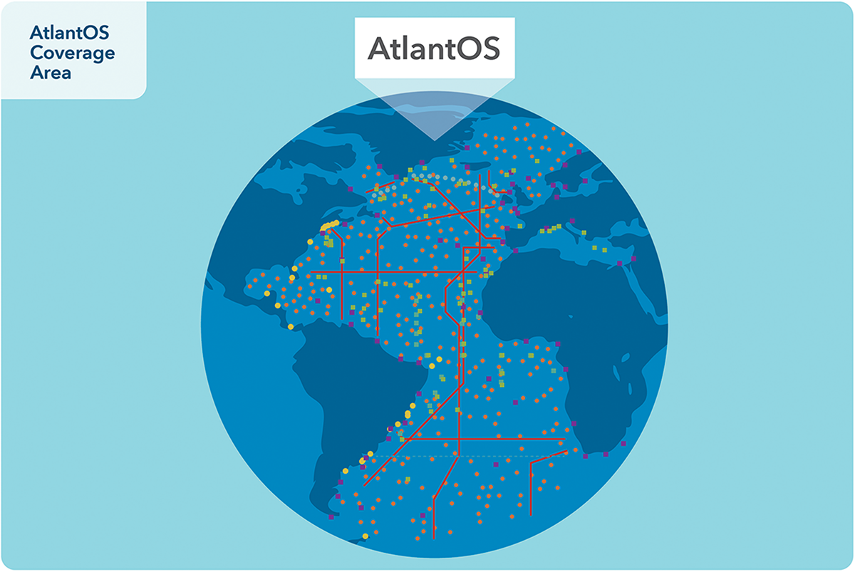
AtlantOS coverage area. The Atlantic Ocean, depicting the focus area of ocean observing for AtlantOS. Dots and lines conceptually indicate current ocean observing activities by major networks, such as Argo, GO-SHIP, PIRATA, and OSNAP.
Ocean observations touch our lives every day from the food we eat, to the clothes we wear, to how we spend our leisure time. The ocean is estimated to be the seventh largest economy in the world. Goods and services from coastal and marine environments have been estimated at US$2.5 trillion each year worldwide (Hoegh-Guldberg et al., 2015).
In building AtlantOS it is important that we define and follow clear and transparent principles. The implementation of this vision will lead to a sustainable comprehensive observing system in the Atlantic basin from which societies, governments, and industries around the Atlantic will benefit (Figure 2). To guide this development, this paper lays out the vision and shows why the community should work together toward and invest in ocean observing. It defines the principles of the system, how partners could contribute, and presents the benefits that will be derived from an effective ocean observing system. This vision then needs to be complemented by the development of an Implementation Plan, that offers a more detailed review that points to the operational challenges and approaches and offers guidance on implementation of the ocean observing system and the roles of different partners.
FIGURE 2
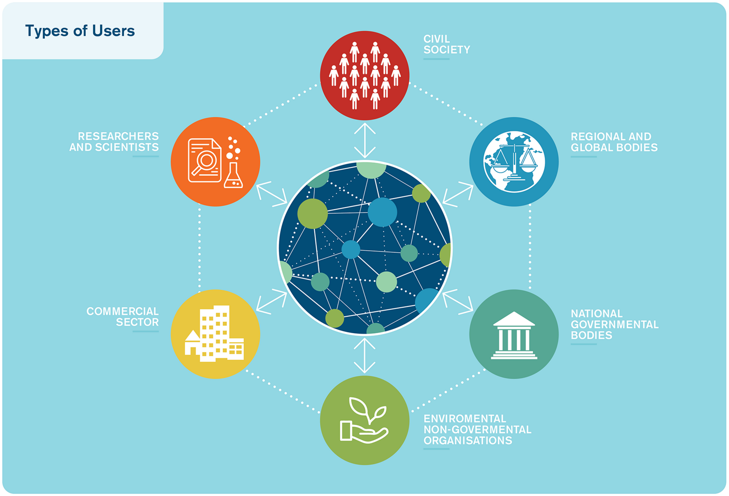
Types of users. The data and data products provided by AtlantOS will support many user groups, ranging from industry to private citizens, from government to non-governmental organizations.
This high-level strategy and its vision were developed to provide a structural framework for guiding the development of the Atlantic Ocean Observing System. We will outline a baseline of core platforms, networks and systems that make up AtlantOS and a path: from initial capability at the beginning of the United Nations (UN) Decade of Ocean Science for Sustainable Development in 2021, to full operating capability at the end of the decade in 2030. The program will build upon past development of ocean observing. Ocean Observations are critical to public services, facilitate commercial activity, support scientific research, foster well-being, and protect lives and property. While much has been accomplished, there remain gaps in fully meeting user needs at the basin-scale.
By 2030, we foresee that AtlantOS will have the following attributes:
- •
AtlantOS is the All-Atlantic part of the Global Ocean Observing System,
- •
All designated AtlantOS data providers are coordinated, integrated and cooperating to efficiently make accessible all relevant Essential Ocean Variables (EOVs) as part of the Global Ocean Observing System and the Group on Earth Observations Blue Planet programme,
- •
User needs are met by keeping connected with users and understanding their evolving requirements,
- •
A fully functioning governance framework is in place and provides a forum for coordination, resource mobilization, review and decision making, and
- •
Long-term sustainability has been achieved through national and stakeholder commitments with a goal of reaching 75% of sustained resources, in line with present meteorological observational support.
Full operating capability does not imply the end of development but an objective that defines the initial establishment of a fully functional AtlantOS. AtlantOS will be an agile system that will evolve as user needs change, new technologies are developed and new frontiers in ocean and earth system research are discovered.
AtlantOS will support many users including governmental and intergovernmental, commercial, non-governmental organizations, and scientific sectors to advance the use of ocean observations in the delivery of public services, sustained economic benefits and earth systems research. We envisage a basin-scale system that is compatible with global aspirations and serves as a model for other ocean basins, to realize the potential of well-integrated ocean information in support of a wide range of benefits including sustainable ocean economy with strong ocean stewardship. AtlantOS will serve a multi-dimensional range of interests relevant to the broader social and economic concerns of society.
Key examples of where AtlantOS ocean observing and information enables benefits:
- •
Disaster Resilience: Storm surge, hurricane and tsunami warnings are provided with enough advanced notice and precision to support successful emergency response.
- •
Blue Economy: Supporting sustainable prosperity from the ocean through advanced seafloor ecosystem mapping and habitat characterization, pollution tracking, identification of renewable energy options, carbon sequestration mechanisms, and other of ecosystem services.
- •
Food Security: Helping to achieve global food security, maximizing the sustainable food benefit that we can extract from the ocean now and in the future, by supporting sustainable fisheries and mariculture operations and management.
- •
Biodiversity and Ecosystem Sustainability: Understanding changes in biodiversity and ecosystems to determine impacts on natural capital and ecosystem services and ensure our ocean resources can support human nutritional, recreational, and health needs. This includes monitoring the present abundance and distribution of organisms and improved forecasting of events such as harmful algal blooms (HABs), marine life mortality, or coral bleaching, which impact recreational and commercial use of the ocean.
- •
Marine Transportation: Forecasts of extreme wave events, hurricanes and tropical storm tracks, forecasts of ocean currents, sea-ice monitoring and iceberg tracking, oil spill and pollutant dispersals, and the locations of whales and other protected species, with advisories to modify ship routes or decrease speeds to avoid collisions in the North Atlantic with the busiest shipping lanes on the planet.
- •
Climate Change: Research that includes climate change indicators, such as the Atlantic Meridional Overturning Circulation, including measurements of ocean heat and circulation providing regional sea level monitoring, ocean circulation changes and climate feedbacks, and changes that affect ocean life, such as regional pH and oxygen levels.
- •
Ocean System Science: Research that allows discovery of new processes and phenomena of the ocean system, supports embedded process observations, enables the development and validation of ocean system models and supports innovation in ocean state assessment and prediction.
As an example of the type of service that could be offered at the basin-scale, the operational ecosystem model SEAPODYM (Spatial Ecosystem And Population Dynamics Model) is used to simulate the mid-trophic levels of the ocean, i.e., the micronekton, and then the spatial dynamics of tuna and their fisheries. The optimal sampling conditions of epipelagic and mesopelagic biomass have been identified with modeling to support the calibration of this ecosystem variables now included in the CMEMS catalog. Then, a new management and monitoring system is proposed for tuna fisheries (Dragon et al., 2015) and illustrated with the Atlantic Albacore tuna. This pre-operational forecast system (Figure 3) can bring value by providing increased information about changes in catch rates due to environmental variability, e.g., changes in abundance over time and space by age class from larvae to adults. It also permits distinction between fishing impact and natural variability of the stock and supports real-time monitoring of fishing activity and stock assessment analyses.
FIGURE 3
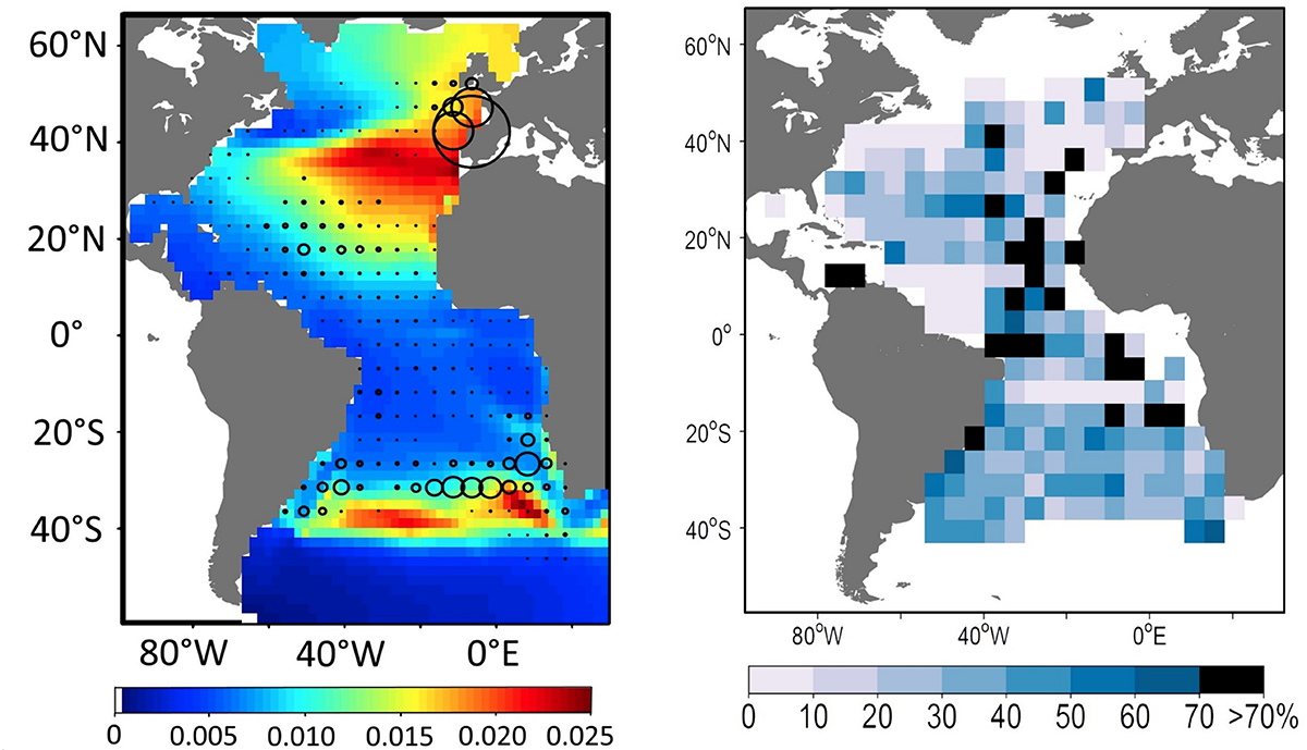
The SEAPODYM (spatial ecosystem and population dynamics model) operational system supports near real-time prediction of albacore tuna stocks in the Atlantic. Left Density of adult fish (kg/km2) and observed catch (circles) in July. Right Error in predicted total catch.
We must see ocean observation as a fundamental requirement for a global society. Over the past century, humanity has come to see roads, electricity, policing and many other services as fundamental requirements of today’s society. So too must we shift our perspective about ocean observation in the twenty-first century. We have a responsibility to act as stewards of our ocean – in our regions and globally, the international community has identified a range of goals and drivers that require systematic ocean observations (e.g., Miloslavich et al., 2018; Tanhua et al., 2019).
The ocean provides crucial resources for humanity and plays a vital role in the global biosphere and climate system. Ocean resources include food, energy, raw materials, recreational use, global trade and cultural services. According to a study by the Organization for Economic Cooperation and Development (OECD), by 2030 the ocean could more than double its contribution to the global economy, reaching over US$ 3 trillion. To conserve and protect our ocean and the vast resources it provides, we must observe and understand ocean regions and how they interact – through transfer of heat, freshwater, nutrients, oxygen, carbon dioxide and marine life.
Improved and sustained observation of our ocean is necessary for informed decision-making to ensure human-ocean interactions are sustainable (Weller et al., 2019). We need coordination of observations, bringing together the data from many sources and countries: surface buoys measuring wind and waves; robots documenting the ocean’s interior, ships and other methods for surveying fish stocks; and satellites providing the view from above. We should share information widely, opening data to many uses and the greatest value. We will save time, money, and energy by working together.
The ocean observing community has produced a Framework for Ocean Observing (Task Team for an Integrated Framework for Sustained Ocean Observing, 2012 – FOO), a guide to help us decide what to measure in our ocean and why. The FOO has been a useful guide in the writing this visionary strategy and will be helpful as we shift focus to the Implementation Plan.
Why Now?
Coordinated ocean observations have been in practice since the creation of GOOS in 1991. GOOS initially focussed on physics and climate issues. As a result of the OceanObs series of conferences (1999, 2009), GOOS was expanded to include ocean chemistry and biology as well as a focus on coastal observing. Indeed, these two meetings laid the foundations for the ocean observing systems that have developed since and documents such as the FOO, which arose from the OceanObs’09 meeting, guide much of the ocean observing community. New demands and expectations, and the upcoming OceanObs’19 meeting, offer opportunities to assess how we are conducting ocean observing and consider fresh approaches.
Our capabilities to observe the ocean, and our understanding of it, have been arisen from key collaborative science programs such as the World Ocean Circulation Experiment (WOCE), the Climate Variability and Predictability Programme (CLIVAR), the Joint Global Ocean Flux Study (JGOFS) and the Global Ocean Ecosystem Dynamics (GLOBEC) programs. These multi-disciplinary, large scale programs stimulated multinational collaborations and stimulated technological developments critical to our present ocean observing systems.
In 2015, the United Nations agreed to the 2030 Agenda for Sustainable Development and its 17 Goals (SDGs), and 195 countries agreed on the Paris Accord. In 2017, a call for action was adopted by member states at the high-level UN Ocean Conference supporting the implementation of SDG 14 to “conserve and sustainably use the oceans, seas and marine resources for sustainable development.” G7 leaders have also shown an interest in the importance of ocean science since 2016, most recently with the 2018 publication, Charlevoix Blueprint for Healthy Oceans, Seas and Resilient Communities.
Two international Atlantic cooperative agreements for marine science provide an incentive and context for a focus on ocean observing with a particular emphasis on the Atlantic. These are: the Galway Statement on Atlantic Ocean Cooperation, signed by the European Union, Canada and the United States of America (U.S.) in 2013; and the Belém Statement on Atlantic Research and Innovation Cooperation, signed by the European Union, South Africa and Brazil in 2017 with additional EU-Argentina and EU-Cabo Verde agreements and the ambition to include other countries around the Atlantic Basin.
Another opportunity for working together and growing ocean observing and information systems is the United Nations Decade of Ocean Science for Sustainable Development (2021–2030) which was declared in late 2017. We must seize these opportunities, to focus our efforts on developing an ocean observing system that fulfills our Atlantic and global stewardship responsibilities.
Meeting User Needs
Meeting user needs begins with assessing the societal benefits of sustained ocean observations, and then understanding how an observing system can provide those benefits (Weller et al., 2019). Growing coastal populations and use of the ocean’s resources are creating increased demand for ocean information. Limited funds mean the observing system must be efficient, cost-effective, and responsive to user needs. We must make the best use of the diverse range of ocean observations available. Much of the work in designing an integrated ocean observing system for the Atlantic Ocean involves ensuring that existing programs are integrated coherently into a system that is fit-for-purpose, i.e., responsive to the needs of stakeholders.
The process of identifying and refining components of the value chain, as discussed in the FOO, from instruments measuring the ocean to information in users’ hands, should be ongoing and iterative. We must pay attention to evolving technologies, changes in the ocean, societal needs, political alignment and leverage, and our ability to use observations to benefit society. Activities at each step in the value chain should be justified by the needs of one or more user communities. Different approaches are possible and all should be employed – bottom up, working from the data, or top–down working from users’ needs. Reviews of the system should be conducted on a regular basis.
GOOS has developed an open-access tool we can use to follow the links in the value chain. We can trace scientific questions, phenomena, Essential Ocean Variables, and the observing networks required to satisfy a societal benefit. Alternatively, we can determine the phenomena and societal benefits that rely on an EOV or on observing networks.
A key challenge is to distinguish what ocean variables are essential (and feasible) from those that are only desirable. The ocean is vast and there are many possible variables to measure, and at many scales. We must focus to ensure that our observations create the greatest benefit. The needs of the users, which are diverse and complex, should be the main consideration for the development of products and services.
The aim of a multiplatform, multidisciplinary, multisector basin-wide system is to optimize observations at basin-scale and maximize the benefits of the data collected. Data from observing platforms should be used for many different observing objectives in real-time and over and over again in delayed mode. The capacity and gap analysis should be done on the full value chain, for both societal benefit and improved scientific understanding.
Challenges in Meeting User Needs
An effective observing network or system needs clear standards for components and careful consideration of the societal benefits. The FOO document identifies lessons learned from the successes of existing observing efforts, and provides an internationally accepted common language and guidance for expanded collaboration in sustained ocean observations. The FOO uses EOVs as a framework to determine the key observations that are required to achieve the goals of the observing system. EOVs are negotiated based on feasibility and impact. Essential means that these observations are the minimum subset required; they are not replaceable by other variables. This framework, while challenging to implement, has been accepted by the user community as a guide to determine the key or essential measurements that should be made.
The review process should involve formal and analytical physical, biogeochemical, biological/ecological, and socio-economic metrics, as well as qualitative approaches. Many aspects of our present observing system, such as some historical coastal stations, were selected based on pragmatic considerations. Expert panels have often played a key role. For example, the observing system for climate was originally developed through international panels such as the Ocean Observing System Development Panel (OOSDP, 1995) and the following Ocean Observing Panel on Climate (OOPC) which supported early developments of sustained ocean observing systems. Today, the advancement of computer models, data assimilation systems and prediction systems have enabled more quantitative, purposeful specifications for ocean observing (Moore et al., 2019). Computer model-based experiments, or Observing System Experiments (OSEs), enable testing of existing observation networks and systems, and Observing System Simulation Experiments (OSSEs), “simulate” testing of future observing networks and systems.
Several international efforts are working to coordinate systematic observing system and modeling system evaluations through programs, e.g., CLIVAR – Global Synthesis and Observations Panel (CLIVAR-GSOP) and the Global Ocean Data Assimilation Experiment (GODAE) Ocean View (now OceanPredict) are two such programs, with a focus on physical oceanography. OceanPredict is also dealing with biogeochemical modeling and data assimilation. The EU Horizon 2020 project AtlantOS includes a focus on the Atlantic Ocean, using state-of-the-art models to refine methods used in computer models (OSSEs, OSEs) to provide consistent, calibrated results. The improvement of observing system technologies must develop hand-in-hand with improvements in modeling and data assimilation systems (see Smith et al., 2019, for some thoughts on approaches to consider). Given our capabilities, we should rely on evidence-based approaches for the design of AtlantOS, the All-Atlantic Ocean Observing System (Ostrander et al., 2019).
Present Ocean Observing in the Atlantic
AtlantOS is not a new system but rather a new approach to provide a comprehensive, state of the art observing system for the Atlantic Basin that can be fully realized and sustained for the long term. AtlantOS will build upon existing observing assets. Like other ocean observing systems, AtlantOS proposes to take measurements of ocean properties and use those measurements to understand how the ocean system functions, how it affects us, and how we affect the ocean. The system must encompass many types of platforms and sensors and needs to fully take into account the synergies and complementarities with present and future satellite observations. We learn a lot about the ocean from satellites including sea level and geostrophic ocean currents, water temperature, ocean color, sea ice, sea surface salinity, waves and winds (Le Traon et al., 2015). Satellites play a critical role in providing real time, global high space and time resolution observations of key ocean variables that are essential to constraining ocean models and for operational use (Le Traon et al., 2019). New capabilities (SWOT, SKIM) are also developed to observe the ocean dynamics at very high resolution (Morrow et al., 2019) or to directly observe surface ocean currents from space. Satellite observations are, however, largely restricted to the ocean surface. To fully understand, describe and forecast the 3D ocean, in situ observations (measurements taken in and out of the water) are mandatory. In situ observations are also essential to calibrate and validate satellite observations.
We still need direct measurements in the ocean – which can be from instruments left at a fixed spot in the ocean, from a ship or from drifting or mobile platforms (e.g., gliders or tagged animals). When we put these different data streams together, plus measurements of the atmosphere, we can see how the ocean and atmosphere work together, giving us a powerful tool to predict what is happening in our ocean and how this supports many societal benefit areas. Using evidence derived from ocean observations, we can keep people safe, support robust communities, and foster sustainable use while enabling the stewardship required to adapt and manage human-ocean interactions in changing ocean ecosystems.
Figure 4 would suggest that the whole ocean is fully covered and begs the question as to why there is concern about the state of ocean observation. Our response is that our observations are constantly improving, but still inadequate to respond to rapidly growing societal needs, and that the coordination and integration of the existing observations is less than it should be. We can get more value out of the effort we presently put into ocean observation. To do this, we need to understand what observing is happening and what user needs those activities meet.
FIGURE 4
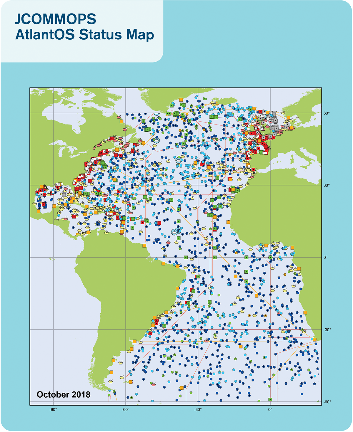
Global ocean observing system (GOOS) status map for September 2018 (Source: JCOMMOPS). Map of the Atlantic Ocean showing the location of ocean platforms (drifters, moorings, buoys, etc.) with onboard instruments collecting ocean observations. Coverage map is of observing activities by GOOS network members.
To begin to realize a fully operational AtlantOS, we have proposed a methodology for determining what elements represent the initial core network and which systems would be included. Existing observing activities can be described in two main forms (Figure 5). Often the terms network and system are used interchangeably, however, networks and systems are different:
FIGURE 5

Difference between systems and networks. Major ocean observing activities can be organized into two categories: Systems and Networks. AtlantOS, as a system, will coordinate networks conducting ocean observing in the Atlantic.
- •
Ocean observing networks are typically platform- or theme-focused activities – where platforms can be ships, moorings, drifters, ocean wave gliders and more, to which instruments can be mounted – based on common technology and data types, and often cater to focused ocean issues; themes include topics such as biodiversity and acidification. Networks are typically founded via international collaborations between research institutes and countries (like GO-SHIP, MBON, OceanSITES, SOOP, and Argo) with the aim to observe the ocean together (Duffy et al., 2013). They have common practices and standards, shared scientific infrastructure within their own network but with policies to share data openly. Global networks, such as Argo, are often built around a particular instrument platform. As an example, the growing High Frequency (HF) Radar network is built around coastal radar networks that provide measurements of coastal current and waves. The focus of networks is generally narrower, technology focussed and more specific than is true for observing systems.
- •
Ocean observing systems are large-scale national, regional or international programs founded and funded by governments and stakeholders that build on networks within a region. Three clear examples (presented later) are GOOS, EuroGOOS/EOOS and the U.S. Integrated Ocean Observing System (U.S. IOOS®). Many different variables are measured in an ocean observing system, such as temperature, sea state, ocean currents, salinity, ocean acidity, dissolved gas concentration, biodiversity or seafloor properties. The motivation is to coordinate ocean observing activities carried out by research institutes within a geographic region. Their purposes depend on societal needs and governmental interests, as well as scientific interests. Observing systems typically have some forms of legal bases. In general, the aim is to institutionalize and manage ocean observing activities on a larger scale. Ocean observing systems promote open access to data and cooperate with their members to develop products for users. Observing systems are set up on a long-term basis. Ocean observing networks are members of ocean observing systems and are supported by them, e.g., via financial contributions.
For the All-Atlantic Ocean Observing System to succeed and provide benefit, ocean observing governance needs to evolve and recognize the basin scale as governing scale. There are key challenges with the coordination and governance of ongoing observation of the Atlantic Ocean:
- •
Today, not all of the networks and systems needed for AtlantOS are affiliated with GOOS and adequately governed or coordinated Some systems, such as U.S. IOOS and EuroGOOS do identify as GOOS Regional Alliances (GRAs) and parts of the global system. Other networks, such as the Marine Biodiversity Observation Network (MBON), reside under the Group on Earth Observations Biodiversity Observation Network (GEO BON) and operate in explicit partnership with GOOS and the IOC. Others are national or regional in scope and governance – often established by treaty or other agreements or to satisfy national reporting requirements; these often exist and operate outside of GOOS or any other global body.
- •
There are differences in how systems are defined. For example, US IOOS is an adaptive, federated network of ocean observation, data management and communications, and modeling and analysis capabilities. EuroGOOS is a non-governmental organization (NGO) that coordinates national observing systems and funds coordinating activities.
These diverse groups, with different structures and responsibilities, present coordination challenges and gaps and there is widespread recognition that those gaps must be addressed if we are to embrace a true basin-scale observing approach.
Ocean observing systems exist also at the sub-basin scale. Two examples are presented here: EuroGOOS is a regional observing system with 42 members from 20 European countries. Members join EuroGOOS to have a single common voice, e.g., at the European Commission level. Since February 2013, EuroGOOS has been established as an international non-profit organization – it can enter into contracts and have direct managerial control over the secretariat. The system promotes an open data policy and funding includes membership contributions, external funding via research projects and tender contracts. At present an European Ocean Observation System (EOOS) is being developed that would integrate EuroGOOS and increase the range of activities from the European system. US IOOS is a nationally-funded program that aims to gather observing data and develop tracking and predictive tools to benefit the economy, the environment, and public safety across their nations and around the globe.
A few key examples of current Atlantic and global ocean observing networks and systems are:
- •
Argo is an international ocean observing network of nearly 4,000 freely profiling floats that measure temperature and salinity in the upper 2,000 meters of the global ocean and are also extending to deeper ocean and bio-geochemistry EOVs. Since 2000, when the network formed, Argo has revolutionized oceanography, providing publicly-accessible data in near real-time. Argo data are vital for understanding ocean temperature, salinity, and current variations and their effects on weather, climate and ecosystems. Argo is a voluntary network, with the implication that long-term funding is not guaranteed. Argo’s primary users are the World Meteorological Organization (WMO), the operational oceanographic services and the research community – easily identified groups with which Argo has close connections. The tight link between users and networks suggests that support from users in systems, such as AtlantOS, may be more challenging as the path from the data collection to the users is harder to identify.
- •
In the Atlantic there are three regional scale observing networks (OSNAP, RAPID, and SAMOC) all measuring the Atlantic Meridional Overturning Circulation (AMOC) that is a major process for moderating climate change, transferring heat and carbon dioxide from the surface to the deep ocean and from the tropics to the subpolar regions. These three networks have simple governance models, taking the governance approach of major international scientific programs, mainly because they have voluntary contribution models and indeed most of the funding comes from scientific funding councils of the contributing nation states.
- •
The Marine Biodiversity Observation Network works in partnership with GOOS, the Ocean Biogeographic Information System (OBIS), and a broad range of global partners to coordinate and make available the marine biological and ecosystem observations needed to ensure living marine resources are sustainably conserved and managed and can support essential human needs. MBON is refining methods for environmental DNA applications in an operational ocean observing context and has developed advanced methods to evaluate marine biogeographic provinces (seascapes) using multidisciplinary satellite remote sensing data. The MBON Pole to Pole initiative is building a community of practice that helps nations to improve conservation planning and environmental impact mitigation, serves the scientific community, and satisfies commitments to the Intergovernmental Science-Policy Platform on Biodiversity and Ecosystem Services (IPBES), Aichi Targets of the Convention of Biological Diversity (CBD), and the UN 2030 Agenda for Sustainable Development Goals, as well as supporting efforts to produce and international, legally binding instrument under UNCLOS (United Nation Convention on the Law of the Sea) on the conservation and sustainable use of marine biological diversity of areas beyond national jurisdiction. MBON Pole to Pole is achieving this goal through: (1) Enhanced coordination of coastal and ocean observations and data collection among nations, (2) improved collection of harmonized data, and furthering data standards and methodologies, (3) integration of physical and biogeochemical observations with biodiversity information to characterize status and trends, and (4) generation of products needed for informed management of the ocean.
- •
PIRATA is a regional-scale ocean observing system in the Tropical Atlantic founded in 1995 and has recently been renamed to “Prediction and Research Moored Array in the Tropical Atlantic.” It is recognized as the reference network of oceanic and atmospheric observations in the Tropical Atlantic, as well as for climate-dedicated research and for operational climate and ocean prediction. The network was designed for studying ocean-atmosphere interactions in the tropical Atlantic that affect regional weather and climate variability on seasonal, interannual and longer time scales. Ocean-atmosphere interactions in this region influence the development of droughts, floods, severe tropical storms and hurricanes, with impacts felt by millions of people in America and Africa. This system is supported mainly by three member countries – the U.S., France and Brazil and collaborates with others such as Germany. The governance structure is more “formal” because the member countries work through a Memorandum of Understanding that is renewed every four to five years.
- •
The IOC-WMO Joint Technical Commission for Oceanography and Marine Meteorology (JCOMMOPS, 2017) provides organizational support through the JCOMM Ocean Coordination Group (OCG) and status reviews and metrics through the JCOMM Operational Program Support (OPS). Most of the programs supported by JCOMM operate as networks and not as systems. Many global networks supported by JCOMM are well-established (e.g., ARGO, GO-SHIP, OceanSITES) but there are new emerging networks such as HF Radar and Ocean Gliders, which are also JCOMM networks. All JCOMM networks support free access to open data and quality control processes.
Challenges for Existing Ocean Observation Networks and Systems
Ideally these existing networks would be integrated into coordinated systems at the global level. That is true for example of the AtlantOS components of Argo, OceanSITES and GO-SHIP. But overall there is a lack of coordination linking the national/regional to the basin-scale (i.e., AtlantOS) and from the basin scale to the global scale. It is therefore the right time to articulate how we can adjust or integrate these component networks to form a desired fit-for-purpose, basin-scale system. While many may agree on the goal for a clearer more integrated system, the steps to reach or achieve this goal are actively debated by the ocean observing community.
Several key issues, or challenges can be identified:
Multiple Sensors and Platforms
First, the existing observing landscape includes many sensors and platforms. Many states conduct monitoring activities within their Exclusive Economic Zone (EEZ) that do not link systematically with the GOOS networks [e.g., Continuous Plankton Recorder (CPR) or fish stock monitoring that respond to EU habitat requirements]. Such activities use platforms and methodologies that meet local/national needs and are managed and archived at the national level. For a sustainable ocean observation system, it will be important to incorporate all these networks into a more connected governance structure. This might be more effectively coordinated at the basin-scale level. The coastal networks should be aligned so that vital ocean information products like storm surge, hurricane, oil spills or harmful algal bloom forecasts as well as changes in distributions of fish or other organisms could be predicted earlier and more reliably.
Focus Too Narrow
Many existing observing networks are too focussed on the physical Essential Ocean Variables articulated by the GOOS physics panel, e.g., ocean temperature, salinity, currents, waves, and sea level. There is increasing interest from users, and the scientific community to incorporate biogeochemistry, biology and ecosystem EOVs; GOOS panels are developing specification sheets and implementation plans to guide that effort, which includes newer activities such as animal tracking. One challenge as we widen the scope of our interest is how to provide guidance (e.g., using the FOO) for practitioners to select from an ever growing set of measurement expectations and requirements.
Independent Operation
Ocean observing networks and systems tend to work and be comfortable within their own structures. Collaborations between the different networks and systems, like the Argo-GO-SHIP cooperation, where the two networks collect overlapping data types and can validate and build on one another, hold valuable potential and are only partly exploited. Increased collaborations will lead to a faster-evolving, more integrated and effective observing in the Atlantic Ocean where time, money, and knowledge would be used in an optimized and sustainable way.
System Evaluation and User Feedback
Ocean observing networks and systems are largely thematically or issue focussed and often started with a scientific need for information. AtlantOS has the ambition to connect existing systems, facilitate platform and information sharing and improve overall system efficiency. However, a system evaluation and feedback mechanism needs to be established to ensure the AtlantOS system is meeting multiple user needs. Thematic reviews, user consultations and discussions and agreements between resource providers are essential.
Lack of Long-Term Funding
Most observing networks lack long-term, sustainable funding. They depend on voluntary contributions from members or national governments, which often change from year to year. Much of the present funding structure is based on research funding and may not be sustainable. Without adequate and reliable sustainable funding, user needs cannot be met and innovation and capacity building will weaken. Governments must recognize the societal and economic benefits of open data policies and equipment and resource sharing. The governance structures of ocean observing systems should be oriented toward reliable, long-term strategies, akin to what we have for weather observations. The funding structures should be similarly aligned. With the development of AtlantOS, we can grow and coordinate collaborations between ocean observing systems, to improve data sharing and build a common data policy, and promote an effective voluntary funding structure and support capacity building activities.
Moving From the Present to Atlantos
In considering how to develop AtlantOS, it is clear that we will not start from nothing. There is a wide array of infrastructure in place. Many global networks presently operate well as do many coastal and regional systems. How do we move forward from this present patchwork of activity to the more coordinated and comprehensive system that we envisage?
A first step is to determine which present networks and systems could form the core of the developing AtlantOS system, which could be emerging networks, and which might best be partners to AtlantOS. In considering the wide array of existing networks and systems, the first step is to define the criteria by which to assess the state and status of a network and system. We suggest following: The general approach to this problem has been addressed practically by the JCOMM OCG (Legler et al., 2016) and as considered in the FOO. Adapting this approach, we suggest four key criteria to consider in determining how to organize existing activities into the basin-scale AtlantOS system:
- 1.
Location and scale – it must take place in the Atlantic. This includes both coastal and open ocean areas but likely not the regional seas such as the Baltic and Mediterranean and the northern and southern boundaries are purposely vague.
- 2.
There should be an intention for operation over multiple years. There is no expectation that funding is guaranteed but there should be a plan for ongoing operations.
- 3.
There must be some formal governance structure including a management team, defined standards and plans and a multi-year strategy for operations.
- 4.
There should be a policy for free and open data that is available in a timely manner.
We reviewed key existing networks and systems in the Atlantic, North and South, and present the following as examples (see Bourlès et al., 2008; Rayner, 2010; Roemmich et al., 2010; Cooke et al., 2011; Duffy et al., 2013; Legler et al., 2015, 2016; McQuatters-Gollop et al., 2015; Talley et al., 2016; Mayer et al., 2018) to demonstrate the types of networks and systems that could be included and to demonstrate that there are many existing activities that could contribute to the developing core of AtlantOS:
Persistent Core Components
Networks
- •
Argo
- •
GO-SHIP
- •
Ocean Tracking Network (OTN)
- •
OceanSITES (including OSNAP, RAPID, SAMOC)
- •
PIRATA
- •
Ship Observations Team (SOT)/Ship-of-Opportunity Programme (SOOP)
- •
Global Ocean Acidification Observing Network (GOA-ON)
- •
Continuous Plankton Recorder
- •
Global Sea Level Observing System (GLOSS)
- •
Marine Biodiversity Observation Network
- •
SeaBed 2030 (GEBCO)
Systems
- •
U.S. Integrated Ocean Observing System
- •
EuroGOOS
- •
South African Environmental Observation Network (SAEON)
- •
Sistema de Monitoramento da Costa Brasileira (SiMCosta) – Brazilian Coastal Monitoring System
Partners
- •
Voluntary Observing Ship (VOS)
- •
Satellite remote sensing (e.g., CEOS)
- •
Tsunameter Networks
- •
Private Sector Installations (Oil-Riggs, Wind Farms, Offshore Mariculture)
- •
NGOs and Civil Society observing
Examples of Emerging Components
- •
OceanGliders
- •
HF Radar
- •
Surface Ocean CO2 Observing Network (SOCONET)
- •
Atlantic Seabed Mapping International Working Group (ASMIWG)
- •
Global Omics Observatory Network (GLOMICON)
- •
Canadian Integrated Ocean Observing System (C-IOOS)
- •
IOCARIBE
- •
OCEATLAN
- •
Global Coral Reef Monitoring Network
The first steps in developing AtlantOS could begin with coordination and integration of those well-established networks that see the benefit of collaboration with an Atlantic focus. The demonstrated benefits of coordination would encourage other groups to join and stimulate further developed of ocean observing in the Atlantic. These benefits should be defined by AtlantOS and their assessment would further support sustainability of these networks and systems and expansion of new ocean observing activity. The two immediate benefits to existing networks and systems would be expanded access and use of data being collected, by reaching wider communities of users, and improved demonstration of the societal benefit derived from the observational activity stimulating improved financial support and long-term sustainability.
AtlantOS will adopt an inclusive operating environment with well established and transparent ways by which new networks and systems can developed, accelerated and adopted as part of the basin-scale system.
Getting Data and Information to Users
Observations have no meaning without open data policies and effective data management. They ensure observations are retained and accessible for current and future users. Data management that enables access, use and interpretation of data and products is essential and must be based on collaboration across activities, such as quality assurance and control (QA/QC), which enable local and interoperable discovery and access, and secure archiving.
The present data management landscape is complex and hard to navigate. There are many specific data management infrastructures for specific date types, which can cause delayed and duplicate data receipts, missing data and metadata, and undocumented data processing procedures. There are also missing data management structures making it hard to retrieve some specific data types. Streamlined, modern data management structures are required: they can simplify, automate, and make more efficient the flow of data. New data systems should be interoperable. This would support routine data exchanges within and between observation networks, and user-friendly tools for data/products discovery, viewing and access. Community standards are the foundation for interoperability (Figure 6).
FIGURE 6
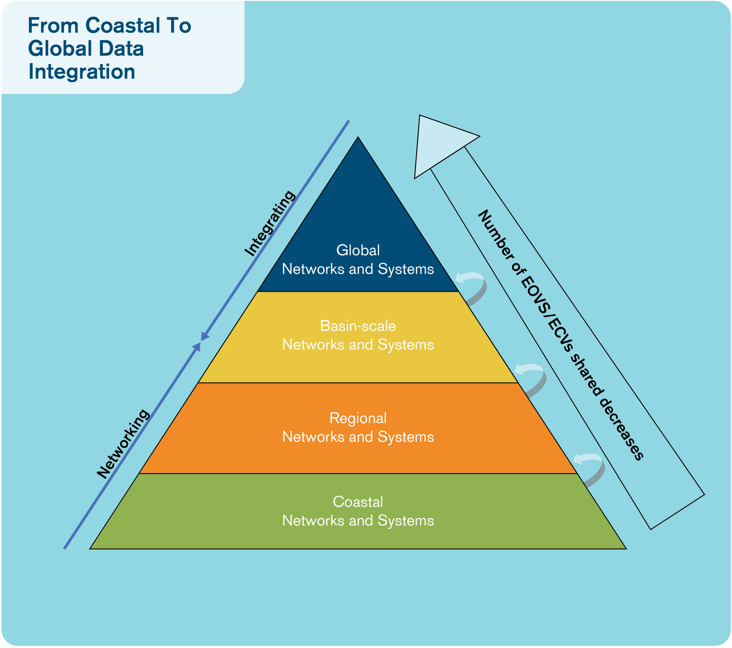
From coastal to global data integration. For data to be made most accessible and used most efficiently, all data management systems must be interoperable, and data must be made available from central data repositories.
We need better coordination of the national and international efforts for data management and communication. Our goal: to harmonize data processing and distribution. It is also important to set up internet portals to make it easy to access a network’s data. Such data portals and access are particularly well-developed in the meteorological community: for example, they support operational meteorology through the World Meteorological Organization. Using and expanding the system of portals that are either EOV-based (primarily for delayed mode data) or platform based (for near real-time data but also scientifically assessed data) supports a rigorous and effective quality assessment service for data providers.
Ocean observations must be available to users on a free and unrestricted basis. There is global recognition that open access encourages wide use of data, and the development of new data products. A key component of data management is close monitoring and quality control of data streams. Communication between the observing system operators and data managers is important. Data centers should give priority to using modern information and communication technology. Data and associated metadata have to be discoverable through portals, catalogs and search engines (Figure 7). To assist discoverability and to ensure correct citation of all data, each dataset requires a unique permanent reference for identification.
FIGURE 7
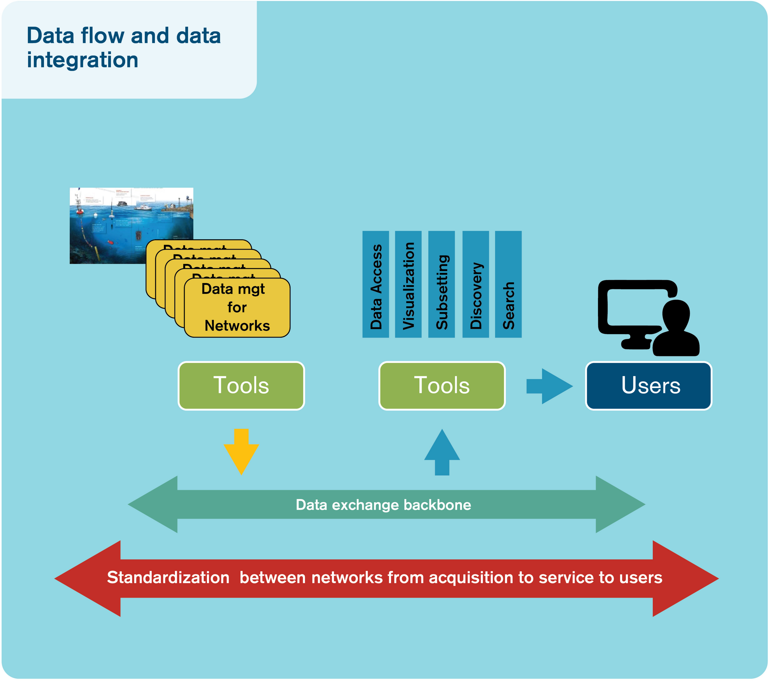
Data flow and data integration. Schematics of the target ocean data flow from observations to users (in yellow: observing network data systems; in blue: integrators; in green and red: harmonization and integration elements). Source: AtlantOS.
Principles and Approaches to Data
The FAIR principles must guide the Atlantic Ocean data management system and should be central to the AtlantOS approach (e.g., Tanhua et al., 2019). There are four FAIR principles. First, data should be Findable – this goal requires globally unique and eternally persistent identifiers for each dataset, rich standardized metadata attached to each dataset, and that data be searchable through standardized discovery services. Second, data should be Accessible – this goal will be achieved by establishing free and unrestricted access to data, ensuring full and open exchange of data, metadata and products, all with minimum delays. Third, data should be Interoperable and understandable – observations should always be provided with at least a minimum set of metadata, to enable traceability. Fourth, data should be Re-usable – there should be comparability built from agreement on quality control procedures, there should be clear recognition and citation to assist discoverability and data should be preserved so that there accessibility will remain indefinitely (Wilkinson et al., 2016).
The study of the many interrelationships that exist in the ocean requires the integration of multidisciplinary approaches and different investigative skills and methods. The ocean observing community therefore has a responsibility to provide the best scientific knowledge, based on international collaboration, to enable wise global strategic decisions. We need to adopt ethical behaviors such as highlighted in the Cape Town Statement on Geoethics: (a) ethical values regarding behavior, honesty, integrity, courtesy and equity; (b) social values calling for sustainability, prevention and education; and (c) cultural values to strengthen community relations (Peppoloni and Di Capua, 2017). The basis and criterion of geo-(marine)ethics is responsibility. Ethics is a sum of all elements that will enable a sustainable research/monitoring endeavor, and we include elements drawn from the philosophical, social, and natural scientific dimensions.
The ocean observation community is responsible to respect for and minimize impacts from research and monitoring on ocean ecosystems, to respect and engage local people in research activities from multiple culture and diverse sector, to work with the goal of global benefit based on reciprocal relation, transparency and responsibility, to maximize efficiency and quality of observations in research activities, engage the society, communicate to and advise policymakers, encourage learning, and share data – acquire once, use multiple times (Buck et al., 2019).
Basin-Scale Computer Models
Coordinated basin-scale modeling will:
inform the blue economy and infrastructure planning,
support ecosystem-based management, and
predict and help mitigate the impacts of human actions and climate change.
Cyberinfrastructure requirements for a coordinated approach to developing basin-scale models will include both high-performance and cloud-based computing. A basin-scale approach requires seamless tools for integrating models, remote sensing observations (e.g., from satellites) and in situ observations, all at the basin and large regional scales. Computer models should be developed using a sequenced approach, building on existing models. A framework for the seamless integration of models, remote sensing and in situ observations (Figure 8) will take time to develop and should address how basin-scale modeling can be seamless. Basin-scale models should be seamless:
FIGURE 8
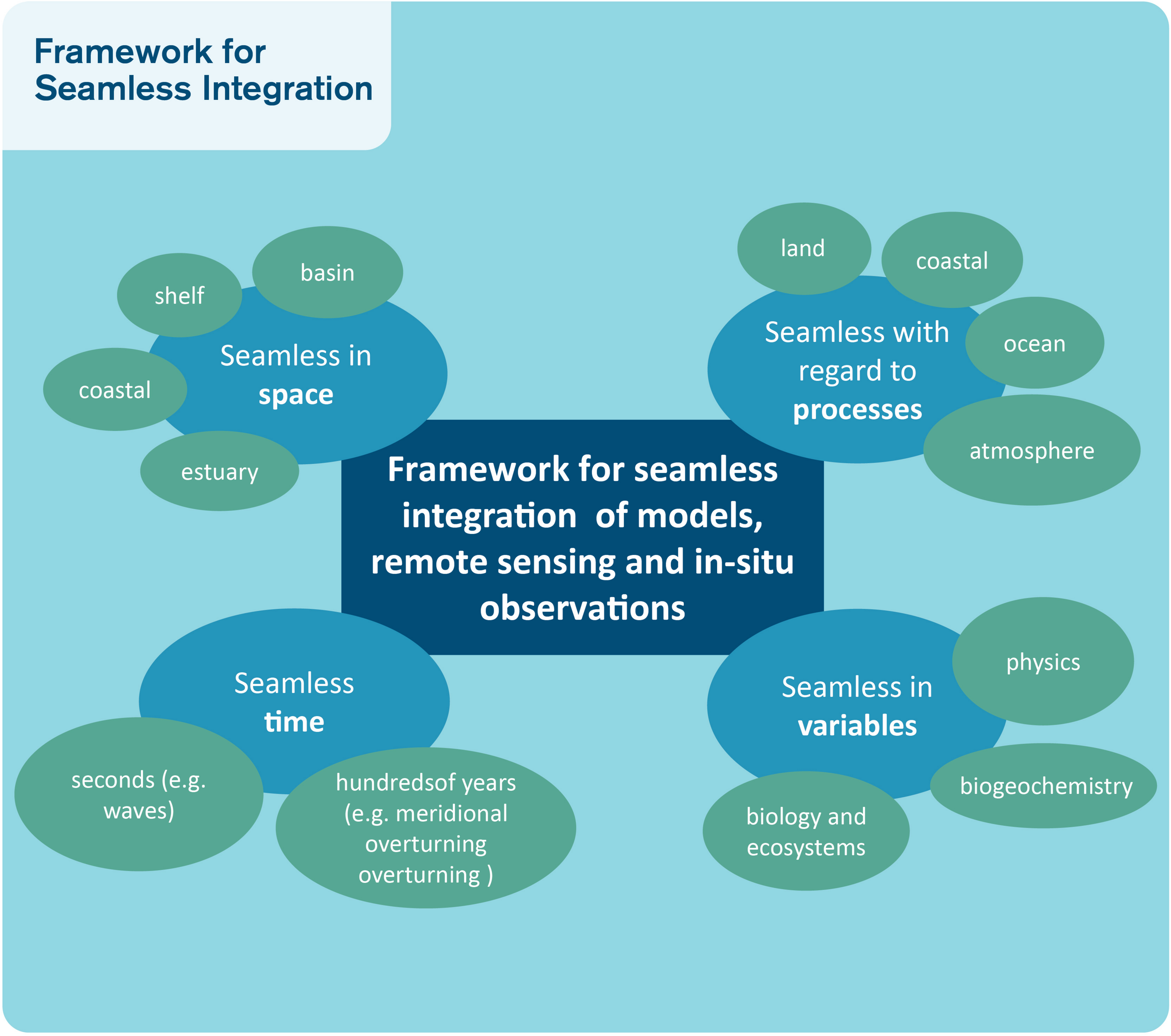
Framework for seamless integration. Content of a framework for the seamless integration of models, remote sensing (satellites) and in situ (in-water) observations.
- •
In space: basin – continental shelf – coastal – estuary;
- •
With regard to processes: land – coastal – ocean – atmosphere;
- •
In time: from seconds (e.g., waves) to hundreds of years (e.g., meridional overturning circulation); and
- •
In variables: referring back to Essential Ocean Variables for physics, biogeochemistry, biology and ecosystems.
Innovation, Good Practice and Capacity Building in Ocean Observing
Innovation is key to ocean observing – it means creating developments or ideas that substantially enhance how we operate. Many different areas of ocean observing have been enhanced by innovation including data communication, integration and sharing; the development and deployment of new sensors and platforms; ocean model guided observing system design, and new cooperative models for observing system governance. Innovation benefits all aspects of ocean observing (Figure 9).
FIGURE 9
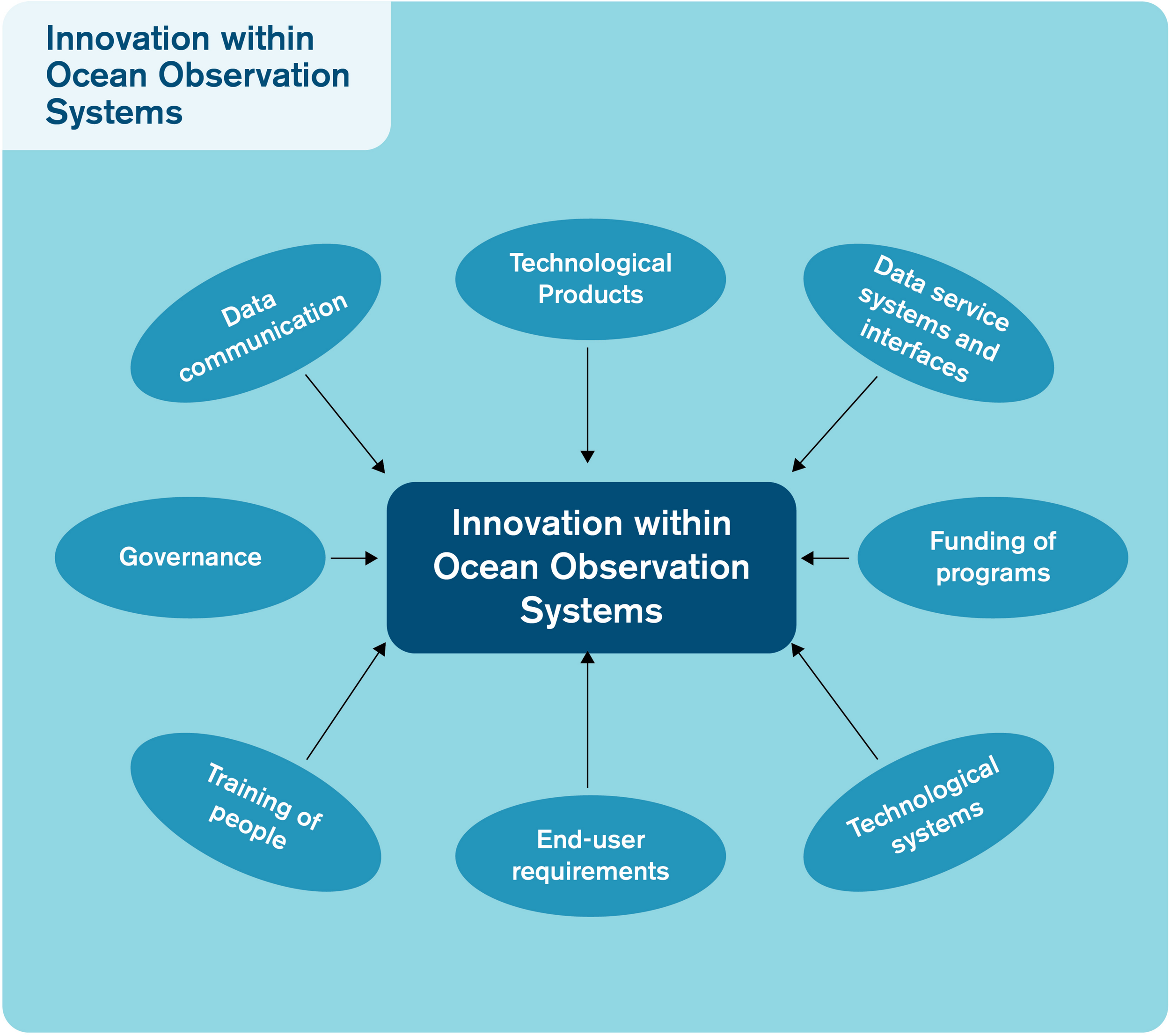
Innovation within ocean observation systems. Innovation in ocean observing can take many forms. For sustainable ocean observing, all forms of innovating, including reviewing and updating, will need to be integrated into AtlantOS.
A key innovation with big impact on ocean observing is citizen science. Citizen science programs are taking off. More and more people are getting involved in science – they’re getting their hands wet! The development and expansion of citizen science programs is well timed. Consumer electronics are becoming part of the scientific arsenal and scientific instruments are increasingly user-friendly. Citizen scientists can now easily and quickly share their data, and the results of their efforts are just as easily shared with the wider community. Advances such as smart sensors, autonomous vehicles, and web-based data systems will enable important roles for citizens in ocean observation. In addition, citizen scientists often have access to areas that are not as often reached by scientists, such as school groups heading to rocky shores, and divers collecting data in shallow ecosystems like kelp forests and seagrass beds.
Even in more extreme and inaccessible environments, citizen scientists are collecting data – from images taken by Remotely Operated Vehicles (ROVs) and Autonomous Underwater Vehicles (AUVs), they are identifying species from the deep sea ecosystems or kelp patches in collections of satellite pictures that span decades. This work is time consuming and would not be possible solely with professional scientists. Citizen scientists are more than ever critical to science, and they offer an opportunity to extend our reach into the ocean and to expand on the partners who will contribute to ocean observing systems. We should encourage further development of citizen science activities and share in the development of best practices for their creation and innovation.
One important aspect of improving ocean observation methods and technology is through sharing technology (Figure 10) and best practices. Partnerships between countries and across ocean sectors permit new opportunities for collaboration and innovation that result in improved ocean observing and downstream information for a large range of societal benefits. The ocean observing community can innovate by developing strategies for the use of new technology.
FIGURE 10
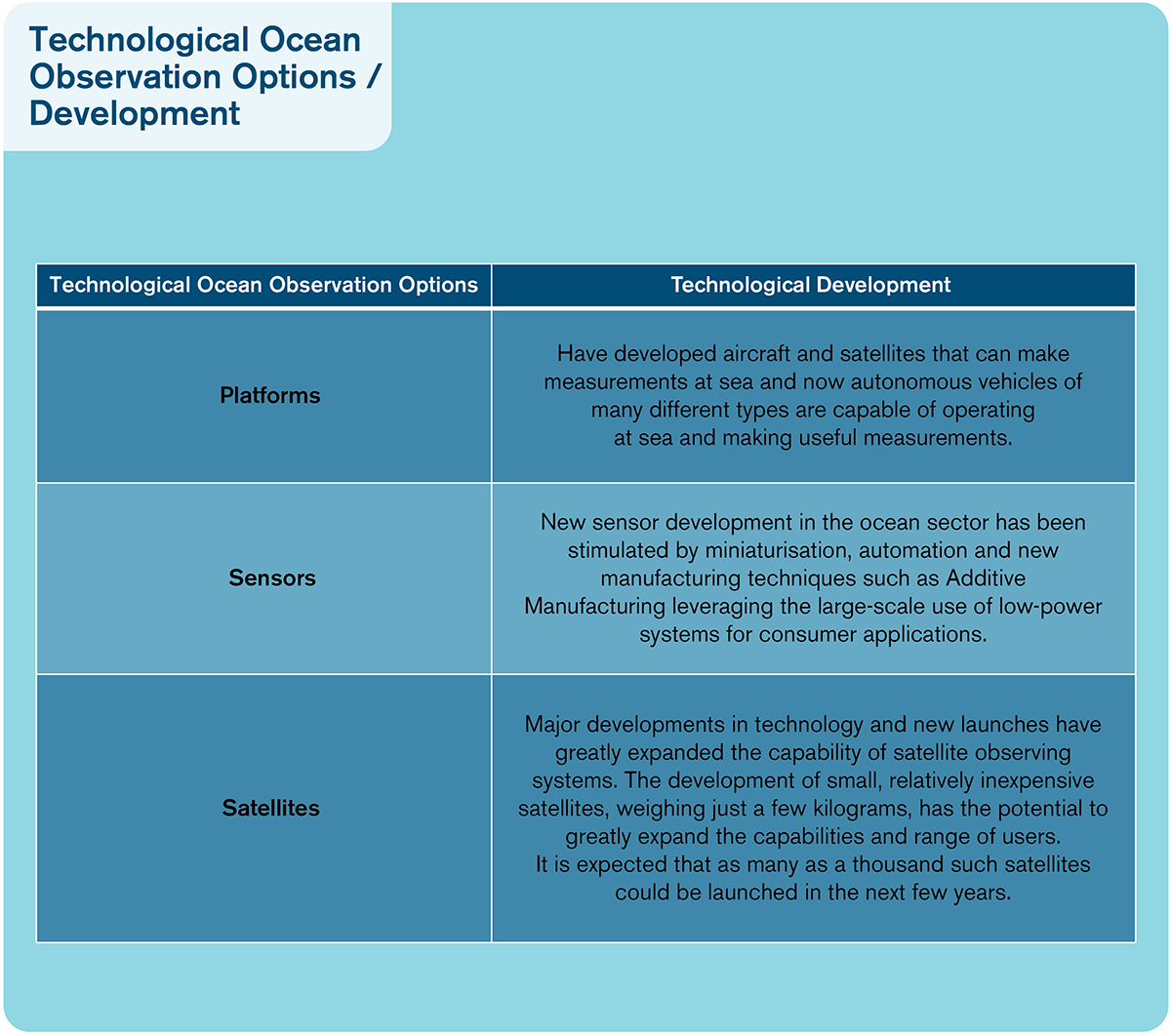
Technological ocean observation options/development. Aspects of technological development leading to innovations in ocean observing.
Capacity building activities benefit the ocean observation community. The biggest challenges to better education and technical skills lie in the disparate opportunities between countries – geographical, political, financial, economic and technical. AtlantOS should include formal structures to support capacity building and innovation, and to share best practices (Figure 11). We must do better to address issues of gender equity and diversity. The voices of those who are poorly represented must be better heard. We must raise our expectations and encourage wider participation in ocean observing to achieve greater participation and inclusion.
FIGURE 11
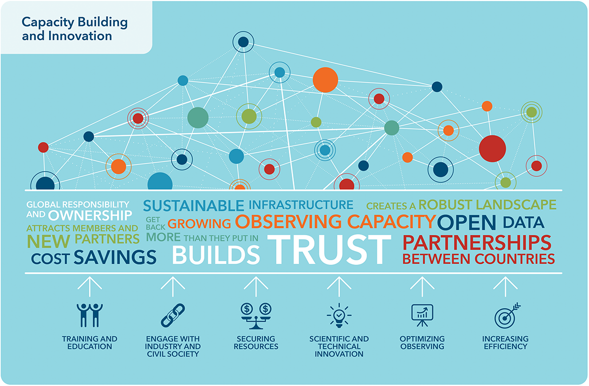
Capacity building and innovation. Activities related to capacity building and innovation should take place across the system and should support and encourage collaboration between the system partners.
Each actor has particular skills and capabilities that should be shared widely across the community. Getting all Atlantic rim countries involved will enable a sense of community and ownership in each. It will also support synergies between infrastructure investments and reduce barriers to multi-national efforts. Capacity building should include fostering cooperation between Atlantic rim countries. Cooperation can be fostered by exchanges of capacity, shared platform deployment opportunities, joint scientific expert teams to ensure high quality and diffusion of data, and focus on new measurements, including biological and bio-geo-chemical and seafloor variables (Barth et al., 2019).
Governance and Partnerships at the Atlantic Basin-Scale
Existing regional and national observation systems have both strengths and weaknesses. Their strengths lie in the transparency of the approaches used by different networks. Their key weakness is a lack of or loose coordination. A clear governance structure requires defined responsibilities and tasks for different actors. In general terms, a governance structure is a collection of functions and activities that support AtlantOS’ development and management of policy, plans, guidance, resources, processes, tools and infrastructure. The degree of governance control varies from the local to the basin-scale systems like AtlantOS. At a local level, governance is straightforward, and funding is often from a single source and is sustained as long as there is a user demand. At the national level, the governance structure becomes more complicated because it often involves more than one agency. For a national level system such as U.S. IOOS, the funding is complicated because different sectors (public, private, and academia) are involved and the governance model is more one of consensus, so funding has become more complex but is still within a single nation. For AtlantOS, governance will be based on the willingness and sense of purpose of individuals, governments and entities. International funding is often complex and tied to the political climate. For AtlantOS to be successful, the management framework must be built upon clearly expressed and transparent principles.
AtlantOS proposes six guiding principles of governance to be adopted and reviewed as the system evolves (Figure 12):
FIGURE 12
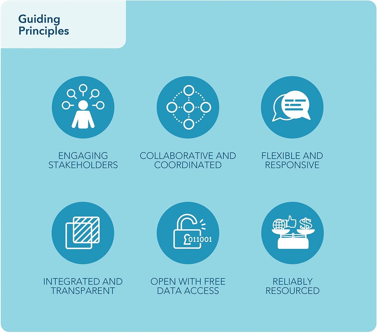
Guiding principles. Six guiding principles of governance have been identified as necessary for creating a sustainable, effectively-governed system.
- •
Engaging Stakeholders: The diverse range of stakeholders must be identified, to address user needs for new and review existing ocean information products.
- •
Collaborative and coordinated: The stakeholder groups should form partnerships to define the roles and responsibilities of the partners and to extend and enhance the observational capability of the network or system.
- •
Integrated and transparent: The network or system should bring together all the observing components, partners and users to ensure that all of their interests are best met and that the maximum value is derived from each component. All partners must recognize and agree to their participation, and understand their expected contributions to and benefits from the observing network or system.
- •
Flexible and responsive: The observation network or system should be adaptive and responsive and have the ability to change in response to a shifting ocean environment and to changes in societal needs and structures.
- •
Open with free access to data and information: The ocean observation network or system should support and promote the open exchange of data to ensure that the maximum benefit is derived from the data collected.
- •
Reliably resourced: An effective ocean observation network or system requires reliable funding to ensure that it is sustainable.
Ocean observing is largely publicly-funded, and therefore public support is required. Present and future networks and systems should build on voluntary participation from governments, research communities, and other stakeholders. Voluntary participation helps to ensure that the partners are actively engaged in supporting and sharing the success of the system and its sustainable nature.
Recommendations for Effective Governance of AtlantOS
Coordination Mechanisms That Span Three Dimensions: The Observing System, Resource Engagement, and Ocean Information Delivery
A single supervisory body is needed to coordinate the three dimensions with their respective tasks and responsibilities. A clear coordination structure of the different subgroups covering the three dimensions should exist, where tasks and responsibilities are distributed between all observation system contributors. As a result, overlapping and loosely coordinated structures that exist now could be streamlined.
An AtlantOS Executive Board
Governance and coordination of the AtlantOS system is important to better connect to the observing systems and networks operating in the Atlantic, and to the global system (GOOS).
A Resource Board to Promote Long-Term Funding
To promote long-term funding, the AtlantOS community should establish a Resource Board on a voluntary basis within this governance system. It should be arranged in a “resource engagement” dimension.
Implementation of a Formalized, Dynamic, and Flexible Ocean Partnership Panel (OPP)
A mechanism to inform the ocean observing community about the role of ocean data and products as well as their societal benefits, with representatives from within each stakeholder group.
A Review Process
Regularly held to determine the adequacy of ocean observing activities and programs, as well as the system’s requirements. A review process would ensure long-term support and sustainability of the system. For this process, countries should be asked for information regarding the adequacy of the system, as well as ways to gain more resources and plans for future activities. The proposed timeline is every 5 years.
Countries Should Establish an Ocean Focal Point or Ocean Ministry
At the national level, responsibilities for ocean activities are often distributed across multiple sectorial actors, such as ministries or agencies (like transportation, finance, or environment). Several nations have already started an internal process to connect its actors and identified an Ocean Observing focal point. This mechanism can develop engagement opportunities, capabilities and national knowledge to more effectively contribute to govern their contributions and engagement with ocean observing and information generation. At the highest level of ambition, it could be beneficial if nations or regions create an Ocean Ministry or Ocean Focal Point Mechanism to combine and coordinate ocean information gathering and to provide advice to their governments and stakeholders on ocean issues (Degnarian and Stone, 2017).
In approaching governance at the basin-scale, spanning the Atlantic, there are already many programs with some form of governance. Many of these existing systems and networks exhibit one or more of the principles outlined, but few of them fully realize these principles. It is therefore a pragmatic challenge as to how to move forward building upon existing structures so that we do not waste effort by working to “reinvent the wheel” but at the same time ensure that we follow the key principles needed to ensure sustainability.
It may be too late to develop a fully new governance structure, as there are too many already in place, from the local to the regional to the global scale. It is also important to recognize that funding for the existing systems and networks has been allocated based upon previous agreements with particular expectations, all of which may be difficult to change. We should avoid harming good governance systems in search of a new perfect governance model. Therefore, care must be taken to build a basin-scale system that can integrate all the relevant existing structures but may evolve to attain a fully integrated governance structure following the principles we laid out.
2030 – Realizing the Vision
In the coming decade, we will likely see many new changes in the ocean. A recent report stated that in the future:
scientific and technological advances are expected to play a crucial role both in addressing many of the ocean-related environmental challenges…and in the further development of ocean-based economic activities (OECD, 2016, p. 13).
Ocean observatories are expected to contribute data and information to these environmental and economic developments. We must shift our perspective as to why we make ocean observations and why we invest in ocean observing systems. Such activities should be seen as fundamental to a global society.
Ocean observing is a necessary service to fulfill our collective stewardship responsibility. To fully realize this service, we must change our view of the value of environmental data. Environmental data should be seen as contributing to the global public good and should be freely available to all. Thus, environmental data collected by fishermen should be openly shared, as too should data on seabed features collected in support of deep-sea mining, alongside scientific data. Commercial interests can be protected while at the same time ensuring that the environmental value of these data is not lost. Providing environmental data for the societal good must be seen as fundamental to a twenty-first century society.
When looking at existing sustainable observing infrastructures and systems that have been funded and implemented over the longer-term, e.g., U.S. IOOS and EuroGOOS, most share the following four characteristics:
- •
Meeting defined user needs;
- •
Inclusiveness such that partners or clients find their interests are served;
- •
Promoting open sharing and exchange of information; and
- •
Promoting partnerships between the private and public sectors, the academic community and users.
For a sustainable AtlantOS to benefit us in the long term, the system needs three key elements (discussed in more detail in the previous sections):
Governance Sustainability
Given that ocean observing is largely publicly-funded, basin-scale, ocean observing must have state support. At the international level, such support should be expressed through a governance framework that provides political and legal guidance, within a functional institutional setting. The governance framework encompasses the policies and rules that give any initiative a legal and political raison d’être. A governance framework also lays down the principles by which the observing system should function. Open data entails that data and information collected within the framework of an observing system should be freely available to all collaborators and of course the general public. Free and open exchange of data and information are essential to support collaboration and encourage cooperation and capacity building. To date, ocean observing has been seen as a scientific-technical rather than socio-political challenge. In the future, an intergovernmental ocean observing system should play a special role in communicating the condition of the ocean to the world (Fritz, 2016). Ocean data governance must ensure that the principle of “measure once, use multiple times” is realized.
Institutional and Operational Sustainability
A coordinating body should be identified to provide a forum for coordinating in situ ocean observing networks. GOOS provides a good example for such a body but must be reviewed and strengthened to balance top–down strategy development amongst the owners/operators/funders of observing stations and intergovernmental bodies with the bottom-up inclusion of the scientific, commercial and societal communities. To date, strategies tend to be priority lists and supply-sided plans for the future. In future, more detailed analyses and interactive foresight processes should be initiated to promote critical and reflective assessments of the current state and future of ocean observing.
Financial Sustainability
The diversity and number of ocean observing initiatives means that financial sustainability will not be equal in all initiatives. At best, financial sustainability of an observing system composed of ocean observing networks will require that, while each effort remains financially independent, together they be embedded in long value chains. From data collection to end use, ocean observing should be driven by providing societal or commercial benefits. To this end, efforts to secure more funding must consider capital vs. operational expenditures, so that technology is acquired and operated over the longer-term. A rigorous and continuous economic assessment of ocean observing is necessary, beginning with an assessment of the value added by investing in ocean observing for funders and stakeholders of an Atlantic Ocean observing system.
Conclusion
Looking forward, we see AtlantOS delivering comprehensive ocean observations that truly address existing and emerging needs of all those living by, working on and impacted by our Atlantic Ocean. We do not need to start from scratch –several successful networks and systems are effective in meeting user needs and can be integrated into this newly formed system. However, several key developments are required to enable the creation of a basin-scale system. New technologies present a wealth of opportunity – for making ocean observations, particularly in biology and biogeochemistry, and for facilitating the open and free access to ocean data to make sure the data we are already collecting can be used by all.
While some new funding is likely necessary to meet our needs, it is not just about spending more money. It is about working together more effectively, being driven by user needs, transparent sharing of data, and minimizing duplication of activities. Most importantly, it is about working together, coordinating our activities, and learning from each other so we can address some of our greatest challenges.
The AtlantOS All-Atlantic Ocean Observing System must be sustainable, offering the best value for the collective community investment. Only through such a basin-scale system can we truly understand our shared ocean, for the benefit of all.
Abbreviations
AMOC, Atlantic Meridional Overturning Circulation (Argo Broad-scale global array of temperature/salinity profiling floats that is a major component of the ocean observing system and exemplifies international collaboration, with 31 nations contributing floats (2017) and a data management system that delivers consistent quality controlled data streams.); ASMIWG, Atlantic Seabed Mapping International Working Group (AtlantOS Atlantic Ocean Observing System [and European Union Horizon 2020 funded project is called ‘AtlantOS – Optimizing and Enhancing the Integrated Atlantic Ocean Observing Systems (2015-2019)]); AUV, Autonomous Underwater Vehicle; BON, Biodiversity Observation Network; CBD, Convention of Biological Diversity; C-IOOS, Canadian Integrated Ocean Observing System; CLIVAR, Climate and Ocean: Variability, Predictability and Change; CLIVAR-GSOP CLIVAR, Global Synthesis and Observations Panel; CPR Continuous Plankton Record; DOI, Data Object Identifier; EEZ, Exclusive Economic Zone; EOOS, European Ocean Observing System; EOV, Essential Ocean Variable (Essential Ocean Variables are a set of quantities derived from observational data that have a high scientific value, and measuring them is technologically feasible. EOVs are suited to providing routine estimates of the ocean state (physical, biogeochemical, ecosystem); EU, European Union; EuroGOOS, European Global Ocean Observing System; FAIR, principles Findable, Accessible, Interoperable and Reusable principles; FOO, Framework for Ocean Observing; G7, Group of 7 nations; GEBCO, General Bathymetric Chart of the Oceans; GEO, Group of Earth Observation; GLOBEC, Global Ocean Ecosystem Dynamics; GLOMICON, Global Omics Observatory Network; GLOSS, Global Sea Level Observing System; GODAE, Global Ocean Data Assimilation Experiment (now OceanPredict); GOOS, Global Ocean Observing System; GOA-ON, Global Ocean Acidification Observing Network; GO-SHIP, Global Ocean Ship-based Hydrographic Investigations Program (GO-SHIP is a globally coordinated network of sustained hydrographic sections that aims to bring together scientists with interests in physical oceanography, the carbon cycle, marine biogeochemistry and ecosystems, and other users and collectors of hydrographic data.); GRA, GOOS Regional Alliance; HABs, Harmful Algal Blooms; HF, High Frequency; IOC, International Oceanographic Commission (IOCARIBE GOOS Regional Alliance for the Caribbean and adjacent regions – responsible for the promotion, development and coordination of IOC marine scientific research programs, the ocean services, and related activities); IPBES, Intergovernmental Science-Policy Platform on Biodiversity and Ecosystem Services; JCOMM, Joint Technical Commission for Oceanography and Marine Meteorology; JCOMM OPS, Joint Technical Commission for Oceanography and Marine Meteorology in situ Observing Programs Support Center; JGOFS, Joint Global Ocean Flux Study; MBON, Marine Biodiversity Observation Network; OBIS, Ocean Biogeographic Information System; OceanSITES, The mission of OceanSITES is to collect, deliver and promote the use of high-quality data from long-term, high-frequency observations at fixed locations in the open ocean. OceanSITES typically aim to collect physical, biogeochemical, and biology/ecosystem data worldwide using open-ocean, full-depth water column as well as the overlying atmosphere; OCEATLAN GOOS, Regional Alliance for the Upper Southwest and Tropical Atlantic – represents the regional efforts of institutions from Argentina, Brazil, and Uruguay to jointly develop and implement an operational oceanographic system to monitor and investigate the oceanic processes in the Upper Southwest and Tropical Atlantic; OCG, Observations Coordination Group; OECD, Organization for Economic Cooperation and Development; OOPC, Ocean Observing Panel on Climate; OOSDP, Ocean Observing System Development Panel; OPP, Ocean Partnership Panel; OSE, Observing System Experiment; OSNAP, Overturning in the Subpolar North Atlantic Program; OSSE, Observation System Simulation Experiment; OTN, Ocean Tracking Network; PIRATA, Prediction and Research Moored Array in the Tropical Atlantic; QA/QC, Quality assurance and quality control; RAPID, Array across the Atlantic at 26°N as well as a project with three phases (2001-2007; 2008-2014 and 2014-2020) to observe different changes in this array that could be responsible for a rapid climate change; ROV, Remotely Operated Vehicle; SAEON, South African Environmental Observation Network; SAMOC, South Atlantic Meridional Overturning Circulation; SEAPODYM, Spatial Ecosystem And Population Dynamics Model; SDG, Sustainable Development Goal; SiMCosta, Sistema de Monitoramento da Costa Brasileira – Brazilian Coastal Monitoring System; SKIM, Sea surface KInematics Multiscale; SOCONET, Surface Ocean CO2 Observing Network; SOOP, Ship-of-Opportunity Programme; SOT, Ship Observations Team; SWOT, Surface Water and Ocean Topography; UN, United Nations; UNCLOS, United Nations Convention on the Law of the Sea; UNESCO, United Nations Educational, Scientific and Cultural Organization; U.S., United States of America; U.S. IOOS, United States Integrated Ocean Observing System; VOS, Voluntary Observing Ship (Programm); WMO, World Meteorological Organization; WOCE, World Ocean Circulation Experiment; XBT XBT, (eXpendable BathyThermograph) is a probe that is dropped from a ship and measures the temperature as it falls through the water. In a joint effort between research and government institutions and the private industry, XBTs are usually launched from cargo, research, or cruise ships.
Statements
Author contributions
BdeY led the process and was the primary author with all co-authors substantially contributing to the document.
Acknowledgments
This manuscript is the output of the “BluePrint for an Integrated Atlantic Ocean Observing System” team that has received funding and support from the European Union’s Horizon 2020 Research and Innovation Programme Project AtlantOS (Grant Agreement No. 633211). We thank P. Lehodey who provided the operational tuna example shown in Figure 3. The team has also received support from the EuroGOOS, the pan-European network that is part of the Global Ocean Observing System (GOOS) of the Intergovernmental Oceanographic Commission (IOC) of the UNESCO and from the Marine Environmental Observation Prediction and Response (MEOPAR) program funded through the Networks of Centers of Excellence Program in Canada and from the Integrated Oceanography and Multiple Uses of the Continental Shelf and the Adjacent Ocean Integrated Center of Oceanography (INCT-Mar COI, CNPq, Proc. 56062/2010-7).
Conflict of interest
ZW was employed by the company Veraison Consulting LLC. The remaining authors declare that the research was conducted in the absence of any commercial or financial relationships that could be construed as a potential conflict of interest.
References
1
BarthJ. A.AllenS. E.DeverE. P.DeweyR. K.EvansW.FeelyR. A.et al (2019). Better regional ocean observing through cross-national cooperation: a case study from the Northeast Pacific.Front. Mar. Sci.6:93.
2
BourlèsB.LumpkinR.McPhadenM. J.HernandezF.NobreP.CamposE.et al (2008). The PIRATA program: history, accomplishments, and future directions.Bul. Am. Meteorol. Soc.891111–1126. 10.1175/2008bams2462.1
3
BuckJ. J. H.BainbridgeS. J.BurgerE. F.KrabergA. C.CasariM.CaseyK. S.et al (2019). Ocean data product integration through innovation-The next level of data interoperability.Front. Mar. Sci.6:32.
4
CookeS. J.IversonS. J.StokesburyM. A. W.HinchS. G.FiskA. T.Vander ZwaagD. L. (2011). Ocean tracking network canada: a network approach to addressing critical issues in fisheries and resource management with implications for ocean governance.Fisheries36583–592. 10.1080/03632415.2011.633464
5
DegnarianN.StoneG. S. (2017). 83 Countries are More Ocean Than Land, World. Available at: https://www.weforum.org/agenda/2017/10/global-ocean-governance-all-at-sea(accessed October 30, 2017).
6
DragonA. C.SeninaI.ConchonA.TitaudO.ArrizabalagaH.LehodeyP. (2015). Modeling spatial population dynamics of North Atlantic Albacore tuna under the influence of both fishing and climate variability.Can. J. Fish. Aquatic Sci.72864–878.
7
DuffyJ. E.Amaral-ZettlerL. A.FautinD. G.PaulayG.RynearsonT. A.SosikH. M.et al (2013). Envisioning a marine biodiversity observation network.Bioscience63350–361. 10.1525/bio.2013.63.5.8
8
FritzJ. S. (2016). Observations, Diplomacy, and the Future of Ocean Governance in Science & Diplomacy. Available at: http://www.sciencediplomacy.org/article/2016/observations-diplomacy-and-future-ocean-governance(accessed October 30, 2017).
9
Hoegh-GuldbergO.TanzerJ.GamblinP.BurgenerV. (2015). Reviving the Ocean Economy: the Case for Action.Gland: WWF International.
10
Le TraonP.-Y.AntoineD.BentamyA.BonekampH.BreivikL. A.ChapronB.et al (2015). Use of satellite observations for operational oceanography: recent achievements and future prospects.J. Operat. Oceanogr.8(Suppl.1.), s12–s27. 10.1080/1755876x.2015.1022050
11
Le TraonP.-Y.ReppucciA.Alvarez FanjulE.AoufL.BehrensA.BelmonteM.et al (2019). From observation to information and users: The Copernicus Marine service perspective.Front. Mar. Sci.6:234. 10.3389/fmars.2019.00234
12
LeglerD. M.FreelandH. J.LumpkinR.BallG.McPhadenM. J.NorthS.et al (2015). The current status of the real-time in situ global ocean observing system for operational oceanography.J. Operat. Oceanogr.8 (Suppl. 2), s189–s200. 10.1080/1755876x.2015.1049883
13
LeglerD. M.MeldrumD. T.HillK. L.CharpentierE. (2016). Coordination and Integration of Global Ocean Observing Through JCOMM.Washington, D.C: American Geophysical Union.
14
MayerL.JakobssonM.AllenG. L.DorschelB.FalconerR.FerriniV. (2018). The nippon foundation—GEBCO seabed 2030 project: the quest to see the world’s oceans completely mapped by 2030.Geosciences863. 10.3390/geosciences8020063
15
McQuatters-GollopA.EdwardsM.HelaouëtP.JohnsD. G.OwensN. J. P.RaitsosD. E. (2015). The continuous plankton recorder survey: how can long-term phytoplankton datasets contribute to the assessment of good environmental status?Estuar., Coast. Shelf Sci.16288–97. 10.1016/j.ecss.2015.05.010
16
MiloslavichP.BaxN. J.SimmonsS. E.KleinE.AppeltansW.Aburto-OropezaO.et al (2018). Essential ocean variables for global sustained observations of biodiversity and ecosystem changes.Glob. Chang. Biol.242416–2433. 10.1111/gcb.14108
17
MooreA. M.MartinM. J.AkellaS.ArangoH. A.BalmasedaM.BertinoL.et al (2019). Synthesis of ocean observations using data assimilation for operational, real-time and reanalysis systems: a more complete picture of the state of the Ocean.Front. Mar. Sci.6:90.
18
MorrowR.FuL. L.ArdhuinF.BenkiranM.ChapronB.CosmeE.et al (2019). Global observations of fine-scale ocean surface topography with the surface water and ocean topography (SWOT) mission.Front. Mar. Sci.6:232
19
OECD (2016). The Ocean Economy in 2030.Paris: OECD Publishing.
20
OOSDP (1995). The Scientific Design for the Common Module of the Global Climate Observing System and the Global Ocean Observing System, Report of the Ocean Observing System Development Panel.College Station, TX: Texas A&M University.
21
JCOMMOPS (2017). Monthly Map September 2017. Available at: http://www.jcommops.org/board?contacts =(accessed October 30, 2017).
22
OstranderC. E.MelissaM. I.LangenbergerF. (2019). An innovative approach to design and evaluate a regional coastal ocean observing system.Front. Mar. Sci.6:111. 10.3389/fmars.2019.00111
23
PeppoloniS.Di CapuaG. (2017). “Ethics,” in Encyclopedia of Engineering Geology, Encyclopedia of Earth Sciences Series, edsBobrowskyP. T.MarkerB. (New York, NY: Springer International Publishing), 1–5.
24
RaynerR. (2010). The US integrated ocean observing system in a global context.Mar. Technol. Soc. J.4426–31. 10.4031/mtsj.44.6.1
25
RoemmichD.BoehmeL.ClaustreH.FreelandH.FukasawaM.GoniG.et al (2010). Integrating the ocean observing system: mobile platforms.Proc. OceanObs933.
26
SmithN.KesslerW. S.CravatteS.SprintallJ.WijffelsS.CroninM. F.et al (2019). Tropical Pacific Observing System.Front. Mar. Sci.6:31.
27
TalleyL. D.FeelyR. A.SloyanB. M.WanninkhofR.BaringerM. O.BullisterJ. L.et al (2016). Changes in ocean heat, carbon content, and ventilation: a review of the first decade of GO-SHIP global repeat hydrography.Ann. Rev. Mar. Sci.8185–215. 10.1146/annurev-marine-052915-100829
28
TanhuaT.PouliquenS.HausmanJ.O’brienK.BricherP.BruinT. D.et al (2019). Ocean FAIR data services.Front. Mar. Sci.10.3389/fmars.2019.00440
29
Task Team for an Integrated Framework for Sustained Ocean Observing (2012). A Framework for Ocean Observing, UNESCO, IOC/INF-1284. Available at: http://www.eoos-ocean.eu/download/GOOSFrameworkOceanObserving.pdf(accessed July 11, 2019).
30
WellerR. A.BakerD. J.GlackinM. M.RobertsS. J.SchmittR. W.TwiggE. S.et al (2019). The challenge of sustaining ocean observations.Front. Mar. Sci.6:105.
31
WilkinsonM. D.DumontierM.AalbersbergI. J.AppletonG.AxtonM.BaakA.et al (2016). The FAIR guiding principles for scientific data management and stewardship.Sci Data.3:160018. 10.1038/sdata.2016.18
Summary
Keywords
ocean observation, Atlantic Ocean, ocean observing system, ocean governance, basin-scale, global ocean observing system, framework for ocean observing
Citation
deYoung B, Visbeck M, de Araujo Filho MC, Baringer MO, Black C, Buch E, Canonico G, Coelho P, Duha JT, Edwards M, Fischer A, Fritz J-S, Ketelhake S, Muelbert J-H, Monteiro P, Nolan G, O’Rourke E, Ott M, Le Traon PY, Pouliquen S, Sousa-Pinto I, Tanhua T, Velho FV and Willis Z (2019) An Integrated All-Atlantic Ocean Observing System in 2030. Front. Mar. Sci. 6:428. doi: 10.3389/fmars.2019.00428
Received
02 November 2018
Accepted
05 July 2019
Published
26 July 2019
Volume
6 - 2019
Edited by
Sabrina Speich, École Normale Supérieure, France
Reviewed by
Tong Lee, NASA Jet Propulsion Laboratory (JPL), United States; Katherine Louise Hill, World Meteorological Organization, Switzerland
Updates
Copyright
© 2019 deYoung, Visbeck, de Araujo Filho, Baringer, Black, Buch, Canonico, Coelho, Duha, Edwards, Fischer, Fritz, Ketelhake, Muelbert, Monteiro, Nolan, O’Rourke, Ott, Le Traon, Pouliquen, Sousa-Pinto, Tanhua, Velho and Willis.
This is an open-access article distributed under the terms of the Creative Commons Attribution License (CC BY). The use, distribution or reproduction in other forums is permitted, provided the original author(s) and the copyright owner(s) are credited and that the original publication in this journal is cited, in accordance with accepted academic practice. No use, distribution or reproduction is permitted which does not comply with these terms.
*Correspondence: Brad deYoung, bdeyoung@mun.ca
This article was submitted to Ocean Observation, a section of the journal Frontiers in Marine Science
Disclaimer
All claims expressed in this article are solely those of the authors and do not necessarily represent those of their affiliated organizations, or those of the publisher, the editors and the reviewers. Any product that may be evaluated in this article or claim that may be made by its manufacturer is not guaranteed or endorsed by the publisher.