 Camilla Mazzucato
- Department of Anthropology, Stanford University, Stanford, CA, United States
Vast in scale and densely inhabited, Late Neolithic Near Eastern megasites have been variously considered in relation to urbanity. Often viewed as failed experiments on the path to proper urbanism or proto-urban sites, these settlements reveal few signs of hierarchical social stratification despite their large size; as such, they represent a challenge for the understanding of early processes of community formation and social integration. Drawing upon a wide range of data and using socio-material network analysis as a methodological tool, this paper explores the way the late Neolithic site of Çatalhöyük was organized internally and specifically the way individual houses were embedded in the wider social fabric of the site. This study sheds light on the nature of the networks of social engagement and affiliation that emerge in the Holocene within large early agricultural communities and the way such networks were manifested.
Introduction
What is a city? When can we talk about an “urban way of life”? And where do cities come from? The debate surrounding “urbanism” has a long and extremely complex history. The issue of what constitutes a city is an inexhaustible topic that is endlessly readdressed and reexamined through a variety of lenses. Investigating urbanism, especially early urbanism, implies having to address an array of crucially interwoven issues that encompass the processes of sedentarization, the intensification of social complexity, the construction of new forms of personal and group identities, negotiation and conflict resolution, the changing nature of the relationship with the natural and the material environment and the shift to a way of life increasingly reliant on agriculture and animal husbandry. The emergence of forms of permanent residence in population dense large-scale settlements during the Neolithic period involved deep transformations of the hunter-gatherer ethos and way of life, so radical that it has been suggested that the process lead to essential cognitive transformations (see Benz and Bauer, 2013; Watkins, 2013; Sterelny and Watkins, 2015; Benz, 2017). Processes of group integration, of community construction and establishment of mechanisms of social regulation started very early in the Epipaleolithic and Early Neolithic (e.g., Kuijt, 2000; Kuijt and Goring-Morris, 2002; Hodder, 2005, 2014a, 2018; Goring-Morris and Belfer-Cohen, 2010, 2011; Belfer-Cohen and Goring-Morris, 2011, 2013, 2017; Benz et al., 2013, 2017; Benz, 2016; Finlayson and Makarewicz, 2017), but it is in the PPNB, with the emergence of large clustered agglomerations (megasites), that such processes “scale-up” to an extent and an intensity that could be interpreted as “almost urban” (Mazzucato, 2016). Jordan is home to the earliest appearance of these settlement types, but others megasites emerged across the late Neolithic Near Eastern landscape and later in the Balkans (Rollefson, 2004, 2010, 2015; Bogaard and Isaakidou, 2010; Chapman, 2010; Menotti and Korvin-Piotrovskiy, 2012; Chapman et al., 2014; Wengrow, 2015).
Within the context of the prehistory of the Near East, the debate surrounding “the city” has been and is still strongly influenced by an enduring quest for the origin of the urban phenomenon (see Bienert, 2001; Gebel, 2002; Rollefson, 2004; Yoffee, 2005; Ben-Shlomo and Garfinkel, 2009). This search primarily developed within a predominant evolutionary framework that views the “city” as emerging out of a linear progression that starts with small settlements and ends up around the 4th millennium with the large southern Mesopotamian Bronze Age urban agglomerations (Ben-Shlomo and Garfinkel, 2009; Gaydarska, 2016, 2017; Ur, 2017). These large and socially stratified settlements located in what is now Iraq typify the canonical form of the early city. This process of spatial and demographic expansion and the parallel increase in nucleation are envisioned as the prelude to state formation and are intimately related to the gradual emergence of hierarchically arranged social forms (see Yoffee, 2005). Childe was the first to observe the flourishing of Mesopotamian cities and to describe it as an abrupt change—an “urban revolution” (Childe, 1950)—a threshold in the evolution of human social forms that brought about a number of changes and features (e.g., the invention of writing and the development of centralized administrations) (Childe, 1950). We know now that the Mesopotamian landscape was punctuated by a number of vast and dense population agglomerations that predate the appearance of the 4th millennium “cities” by a millennium, for example, Tell Brak (Wengrow, 2010; Ur, 2014, 2016, 2017). Sites like Tell Brak are usually defined as “proto-urban” and considered part of those “successful” experiments that flourished through the adoption of social and political institutions to mitigate inter-community conflicts, ultimately anticipating the advent of “proper” cities such as Uruk in southern Mesopotamia (Oates et al., 2007; Ur, 2017). Within this framework, population density, settlement nucleation and the origin of centralized institutions and stratified societies developed together and are deeply correlated. This generally assumed strict correlation is challenged, however, by a series of finds and settlement types (Wengrow, 2015). It is worth noticing here, that early forms of centralized administration, recording and storage management are attested from the 6th millennium. BCE within small agriculture villages like Tell Sabi Abyad in Syria (Akkermans and Verhoeven, 1995; Wengrow, 2010; Akkermans, 2014). Additionally, the Neolithic megasites complicate this narrative, since they are both population dense, inhabited for a long time and lack any clear sign of centralized systems of administration or hierarchical arrangements of power. Neolithic megasites, such as Çatalhöyük, have been variously defined as “severe anomalies” (Fletcher, 1995. p. 189) or “dead ends” (Ben-Shlomo and Garfinkel, 2009. p. 203) on the way to true urbanity; alternatively, they have been viewed as proto-urban sites or “proto-cities”: early “experiments” with social nucleation that didn't continue any further (Ur, 2017. p. 140). Instead, these settlements and finds seem to point to a much more flexible and complex scenario of multiple trajectories and experiences that can be hardly restricted within linear and univocal narratives and that suggest the need for a focused contextual approach and a bottom-up perspective that rather of trying to restrict the different settlement forms and practices within normative categories is concerned with the way these sites were internally organized, on which socio-material practices formed their fabric and how they changed through time and space (Hodder, 2005; Asouti, 2006; Düring, 2007a,b, 2013; Wengrow, 2015; Mazzucato, 2016; Der and Issavi, 2017).
This paper is part of an ongoing program of research that explores mechanisms of social integration and group formation within the site of Çatalhöyük. Using a socio-material network approach and a community detection method, it is focused on identifying and disentangling the dynamics of interconnectivity and patterns of affiliation and cooperation between buildings and how these reflect the material choices and the spatial organization at the site. Furthermore, it aims to highlight social units larger than the single house (e.g., neighborhoods, corporate groups or sodalities) and to inspect the way they were embedded within the wider site. This study contributes to the debate regarding the way megasites were internally organized and their forms of social integration furthermore, it contributes to the discussion regarding forms of Neolithic corporate identities (see Hodder and Pels, 2010; Hodder, 2014b; Bogaard, 2015; Benz et al., 2017; Kuijt, 2018). Socio-material network methods are used as the methodological tool for investigating these issues because they provide the opportunity to consider connectivity and dependencies between units of analysis in a synthetic way that incorporates different material classes.
The Anatomy of Çatalhöyük
Catalhöyük is typically considered one of the larger Near Eastern Neolithic settlement sites (13.5 ha) (Figure 1). First discovered and excavated by James Mellaart between 1961 and 1965, it has been investigated by the Çatalhöyük Research Project (ÇRP) under the direction of Ian Hodder since 1993.
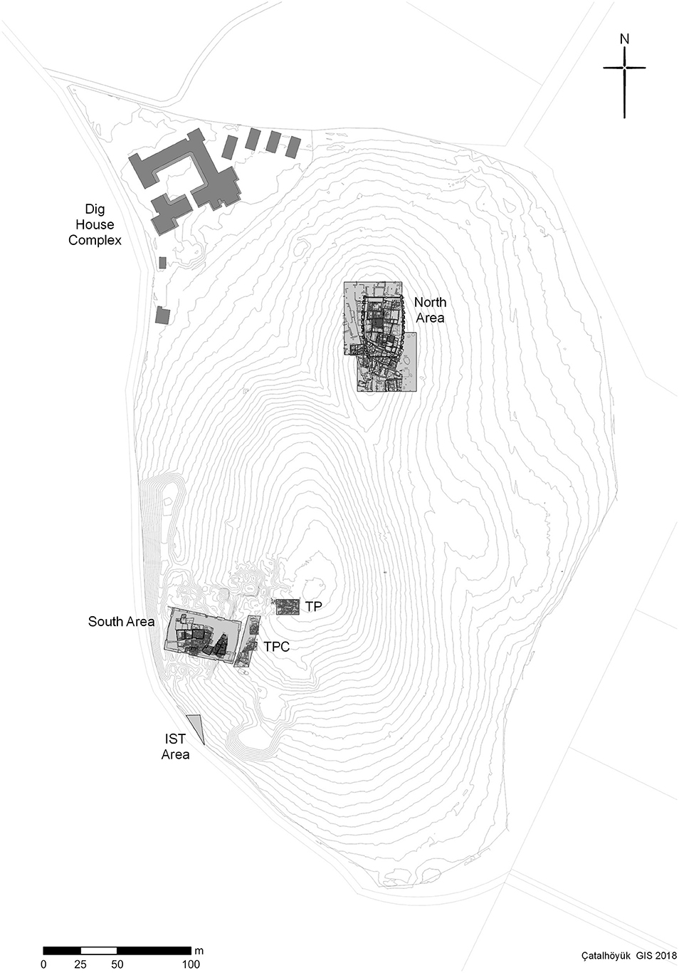
Figure 1. Çatalhöyük East Mound plan. Main excavation areas highlighted in gray. (Plan: Camilla Mazzucato. Used by permission of the Çatalhöyük Research Project).
The Neolithic occupation at Çatalhöyük extends for more than a millennium (7100–6000 cal. BC) (Bayliss et al., 2015) and is characterized by sequences of mudbrick buildings constructed one on top of the other and, at intervals, separated by external spaces such as middens and penning yards. Çatalhöyük shows no signs of deliberate planning; instead, the site seems to have developed an organic, modular arrangement through the repetition of similar structures. Mudbrick buildings were densely packed in a close-knit fabric that did not allow for the presence of roads or significant open areas. As with other Neolithic megasites (e.g., Basta, Ba' ja, Aşiklı Höyük), Çatalhöyük's houses formed the center of domestic and ritual life and were characterized by a highly regular repetition of the same elements, while at the same time revealing smaller idiosyncrasies (in terms of size, layout, material culture) that resulted in each house being slightly different and independent, and having a specific identity (Asouti, 2006; Hodder, 2014a; Hodder and Farid, 2014).
Despite being constructed very close to each other, houses at Çatalhöyük are, throughout the entire sequence, easy to distinguish spatially. Shared party walls are very rare and mainly confined to the early levels; instead, houses are typically delimited by independent walls (Hodder, 2005; Düring, 2007a,b). These independent rectilinear mudbrick walls usually delimit a central living area and smaller side rooms used for storage or food processing. Except for some houses in the early occupation of the site, the living area is typically divided into a northern sector where burials, wall paintings, installations and, in general, symbolic features were located, and a southern sector where fire installations (e.g., ovens and hearths) are located and food preparation and domestic activities took place (Hodder, 2005, 2013, 2014a; Hodder and Farid, 2014). Throughout the entire sequence, houses at the site are the focus of burial activity, symbolic elaboration, small-scale food processing, consumption and small-scale production activity (Bogaard et al., 2009; Bains et al., 2013; Carter and Milic, 2013; Demirergi et al., 2014). While the houses at Çatalhöyük were clearly durable spaces in which the concerns of the site's inhabitants for memory and time depth are revealed through repetitive practices, they were also dynamic and continually evolving structures. Houses at Çatalhöyük were repeatedly modified over the course of their occupation. Wall installations and paintings were ephemeral features that changed frequently, together with many of the houses' internal structural elements (Hodder, 2005, 2013, 2014a; Düring, 2007a,b; Hodder and Farid, 2014).
Here some terminological clarifications should be made before carrying on. In this study the term building and house will be used interchangeably, and they refer to the above described spatial unit whose modular repetition characterizes Çatalhöyük's clustered configuration. The term household will point, instead, to a more flexible entity, a unit of people or a “social group” that may or may not coincide with the architecturally defined house, which is defined by cooperation within the social, economic (sharing of economic resources) and ideological “sphere” (Düring, 2007a,b; Souvatzi, 2007, 2008, 2012). In addition to the small-scale nature of consumption and production observed, and the lack of evidence for inequalities between houses, the modular nature of the buildings and their remarkable uniformity suggests the possibility that buildings at Çatalhöyük represent independent units, i.e., “discrete household residences” (Düring, 2007b. p. 163).
While no clear evidence for social stratification has been observed archaeologically at Çatalhöyük, horizontal differences and variations between buildings have been detected. These variations were first explained by Mellaart through the lens of a stratified society. He characterized some of the most elaborate houses he excavated as “shrines,” and the areas where these “shrines” tended to cluster as “priestly quarters” (Mellaart, 1967). Since the beginning of the Hodder project, however, interpretations of the differences between buildings and the social geography of the site have diverged from those of Mellaart. Hodder and Pels (2010) see the distinction between ordinary houses through the lens of Lévi-Strauss' concept of house societies (1979); here they make a distinction between standard houses and “history houses” and suggest the existence of complex series of dependencies between them (Hodder and Pels, 2010). History houses suggest a process of differentiation involving the accumulation of social memory that is materialized in symbolic elaborations such as wall paintings and plastered animal installations that marked these buildings as important focal points for community subgroups (Düring, 2007b; Hodder and Pels, 2010). Not dissimilarly, Düring and Marciniak (2006) highlight the role of “social associations” beyond the house as a principle of social organization at Çatalhöyük and at other Anatolian Neolithic sites (e.g., Aşiklı Höyük, Canhasan III). Houses are viewed as embedded in clustered neighborhoods, possibly as satellites of particular focal buildings (Düring and Marciniak, 2006). Within this framework, spatial proximity represents a very important organizing principle of the social fabric that can be observed as it changed through time. A similar supra- household organization is reflected in architectural clustering and forms of ritual affiliations at other megasites, for example at ‘Ain Ghazal (Rollefson, 2015). Less concerned with spatial location as a factor in social organization is the interpretation of Çatalhöyük's social arrangement in sort of “social mosaic” (Hodder, 2014b. p. 151) formed by “flexible networks” (Mills, 2014. p. 179) of cross-cutting social groupings (e.g., religious sodalities) that overlapped to form a “tightly-knit and highly successful society” (Hodder, 2014b. p. 167). Mills (2014) suggests that history houses acquire prestige and power through networks of affiliations and relations with other houses. Both Hodder and Mills envision a social structure comprised of autonomous houses situated within cross-cutting series of relationships and dependencies with other houses. In a similar vein, Bogaard and co-workers refer to forms of cooperative farming at Çatalhöyük and at other PPN-PN sites (Bogaard, 2015, 2017; Bogaard et al., 2017). Kuijt (2018) has recently suggested that the social geography of Çatalhöyük can best be characterized as an expression of households as multi-family houses. Applying Lévi-Strauss' concept of house society, Kuijt attributes specific function to particular houses (e.g., places for burying the dead or places for symbolic elaboration) used by an extended/multi-family household made up of different families/components kept together by affiliation/membership spatially spread in clusters of structures.
Recent research at Çatalhöyük has highlighted a clear shift in social arrangements between an early phase (pre XII level–Levels South O/North G–before 6500 B.C) characterized by a complex entanglement of dependencies between social groups and a late phase during which it appears that single households emerge as more independent units and the social organization of the community appears more fragmented and dispersed (Levels South P/North H- TP–after 6500 B.C.). The codified, collective social practices observed in the early levels are abandoned and a more autonomous, household-based expression of community emerges (Hodder, 2013, 2014b; Marciniak, 2015; Marciniak et al., 2015). These developments should be viewed within broader regional and Anatolian trends, especially the overall tendency toward household autonomy and production intensification (Flannery, 1972, 2002; Boyd, 2005; Düring, 2006, 2007a; Kuijt, 2008; Hodder, 2013). Despite these observed temporal changes, however, the population seems to have maintained an egalitarian ethos until the abandonment of the East Mound at the end of the Neolithic (~6000 cal. BC). For example, no major differentiation in terms of storage capacity or intensity of production within houses has been observed.
Relational models, such as the ones employed in the current study, appear to well represent the set of horizontal ties that structured society at the site, making Çatalhöyük and other megasites an ideal place to explore the potentialities and limits of socio-material archaeological network approaches as a means of answering archaeological questions.
Tying the Knot: Socio-Material Similarity Networks at Çatalhöyük
Socio-material archaeological network methods fall within the discipline of Network Science (Brandes et al., 2013). Brughmans (2010. p. 277) defines them as a means of “detecting and interpreting patterns of relationships between subjects of research interest.” They are based on the premise that a series of archaeologically observed phenomena can be abstracted as systems that “exhibit an interdependent organization” and that, within these systems, sets of associations between elements can be conceptualized as links that form network models (Brandes et al., 2013. p. 3). Network models are abstractions formed of individual elements or entities represented as nodes (or vertices) and connected by lines (or links/ties) that represent some form of relation between nodes. As such, entities are analyzed in terms of their embeddedness within sets of relations; they are therefore never autonomous but always dependent on the behavior of all the other entities and their connections (Borgatti et al., 2009; Marin and Wellman, 2011). This type of approach is built on the observation that, instead of focusing on entities in isolation, analyzing the connections or the set of relations between them provides a much deeper understanding of the dynamics of specific phenomena (Borgatti et al., 2009; Knappett, 2011; Brughmans, 2013; Mol, 2014; Collar et al., 2015; Brughmans et al., 2016).
At Çatalhöyük the entities/nodes in the network are represented by individual buildings whose relationships to other buildings are established based on the repeating of specific material features. Socio-material networks are, therefore, traced through similarities between material culture and through the co-occurrence of specific features that are used as the way of constructing links among entities. Individual buildings at Çatalhöyük have been chosen as the major system entities (nodes) because they are the key component of the social fabric and, despite differences and changes through time, they represent the main and enduring principle of social organization (Tringham, 2000; Hodder and Pels, 2010; Souvatzi, 2012; Düring, 2013; Baird et al., 2016). The house—with its location in the landscape and the materials associated with it—offers the necessary link for network modeling. Thus, it is the “materiality, spatiality, historicity, and specificity” of buildings that make them appropriate analytical units at the site (Souvatzi, 2012. p. 4).
The material features that are used to establish relationships between buildings and to infer their shared affiliation, have been selected from the full range of archaeological data recorded at Çatalhöyük between 1993 and 2017 (Table 1). These data should be understood as the “material traces” of the processes of producing “social relations” in everyday life (Joyce, 2015. p. 185) and as footprints of the “choices in the way people engaged with objects” and of the act of reproducing social relations (Mills, 2016. p. 247). They represent situated practices indicating communalities that link households to form communities within the overall site (Pollock, 2006). Using all the material classes together has the advantage of considering all materials in a sort of “flat,” non-hierarchical way that avoids dichotomizing the dataset between ritual and domestic or private and public. At Çatalhöyük these differences (e.g., between domestic and ritual) are always difficult to disentangle and various elements are intertwined in such a manner that separating or differentiating between them is impossible (Hodder, 2014a).
Table 1. Objects/practices.
This approach is based on the assumption that the higher the level of similarity between buildings, the higher the probability that they were somehow affiliated; this assumption forms the basis of previous archaeological network analyses (see Östborn and Gerding, 2014 for a review and Mills et al., 2018; Giomi and Peeples, 2019 for recent applications). Furthermore, this approach acknowledges that the complexity of Çatalhöyük's history can be grasped only by combining the widest possible number of datasets, even if they are not obviously related, and that a relational and contextual process of “assemblage” of strands of evidence is needed to produce robust interpretations (Hodder, 2014a, 2015).
A large part of this dataset is based on the architectural elements that form the structure of houses (e.g., location of ovens and benches or location of highest platforms) as well as the burial assemblages within them (e.g., the presence of secondary burial types or pigments or of specific shell species). Additionally, a vast range of other object types and data categories that form the assemblages of buildings have been used to create connections (Table 1). Some material features have been selected because they represent a sort of variation from the normative setting of houses, for example ovens located in the southern part of buildings is not recorded in this network dataset because this represents the usual location of fire installations at Çatalhöyük. In contrast, the presence of ovens located in the northern sector of buildings, or ovens that shift to the southwest corner, have been recorded as they provide more information on variations in practice on site.
It should be highlighted here that this approach acknowledges that network models created using archeological data are different from straightforward social networks in that they aim to reconstruct social dynamics, but they can only be created using material culture as a proxy for social relations (Knappett, 2011, 2016; Brandes et al., 2013; Hodder and Mol, 2015; Peeples et al., 2016; Van Oyen, 2016). Strictly speaking, these networks are neither social nor material but “socio-material” in nature (Knappett, 2011). In this method, society and material culture are conceived as interdependent systems.
For the purpose of this research I will use two different types of networks: 2-mode networks and 1-mode weighted networks of both buildings and artifacts (Figure 2). All the buildings excavated by the ÇRP are arranged within three main temporal groupings or periods (early, middle, late) (Table 2). These “macro-phases” are obtained by collapsing several stratigraphic levels at Çatalhöyük into larger chronological periods in order to generate networks that are chronologically consistent and populated by an adequate number of nodes for analysis.
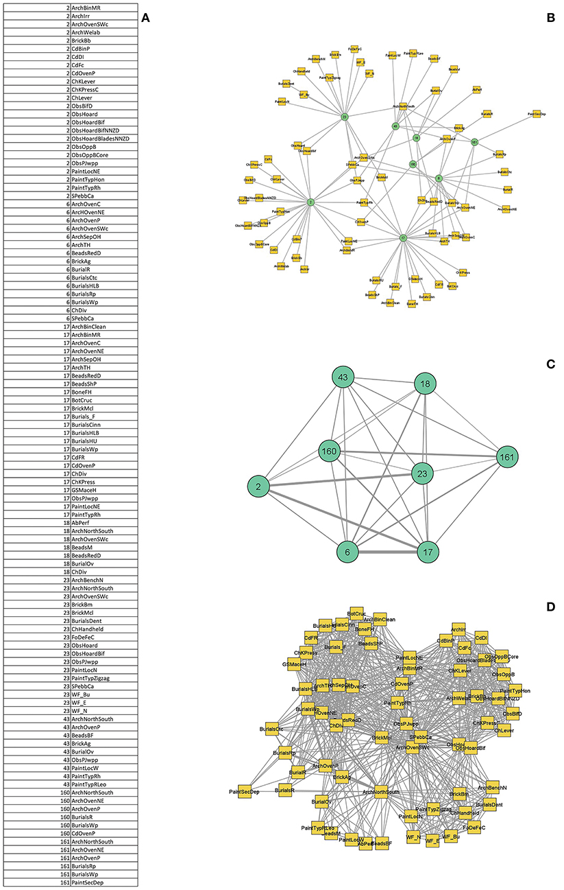
Figure 2. Relevant objects and buildings are recorded and arranged in a nodelist format (UCINET) (A) and displayed as a 2-mode network (B). 2-mode networks or affiliated networks are made of 2 type of nodes in this case of buildings and objects that are linked (affiliated) to one another. The 2-mode network can be converted in weighted 1-mode networks of buildings (C) or objects (D). The weighted 1-mode network of buildings links the building (nodes) that share the same objects. The weight of links represents the amount of object that link each couple of buildings. The 1-mode network of objects on the contrary links the object that are co-present in the same building and the weight of the link correspond to the number of buildings shared by couple of objects.
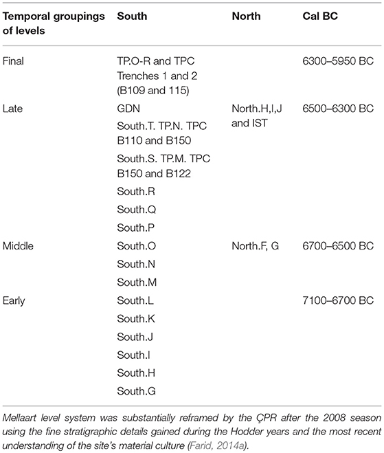
Table 2. Çatalhöyük phases/levels and macro-phases used as chronological frame in network construction (early, middle, late).
For each macro-phase the presence/absence of specific objects or practice are recorded as a nodelist (nodelist2 – UCINET) (Figure 2A) which is then displayed as a 2-mode network (Figure 2B). 2-mode or affiliation networks are made of two different type of nodes, in this case buildings and “objects,” and of ties that link directly only the different node types (Borgatti and Everett, 1997; Prell, 2012; Borgatti et al., 2013). The 2-mode network can be then projected as a weighted 1-mode network of buildings (Figure 2C) or “objects” (Figure 2D); for the purpose of this article I will focus on both the weighted network of buildings and of objects. The 1-mode network of buildings links individual buildings (nodes) through weighted ties; the weight of ties is determined by the number of objects shared by dyads of buildings. The projected 1-mode network of “objects” links the artifacts/practices that are recorded as co-present in the same building. Therefore, the weight of links represents in these networks the amount of buildings shared by dyads of artifacts. These extracted 1-mode networks are proper archaeology similarity networks (ASN) as described by Prignano et al. : “spatial networks derived as the one-mode version (projection) of (weighted) bipartite networks” (Prignano et al., 2017. p. 5), even if, for this study 1-mode networks are the result of the projection binary bipartite networks.
Two-mode networks are largely used for this study as a useful tool for better observing the way objects bring building together in networks; they are a more transparent way of investigating the relationship between “people” and artifact types within “mutually constitutive networks” (Knappett, 2011; Mol, 2014. p. 89).
Community detection analysis has been performed only on 1-mode weighted networks of buildings to determine clusters of buildings that show a tighter material connectivity between themselves compared to buildings that belong to other groups. Generally, networks are not binarized since weights of ties provide the research with extremely important information regarding the intensity or possibly duration of connection (Peeples and Roberts, 2013).
Detecting Communities in Networks
Social networks tend to have a highly inhomogeneous structure characterized by an arrangement that appears to naturally subdivide into areas of tightly interconnected nodes and, subsequently, of high concentration of edges. These groups of nodes, that are very dense within themselves but display exiguous connection with other groups are called communities, clusters or modules (Newman, 2003a, 2006; Fortunato, 2010). Therefore, within communities, nodes display a higher intensity of interaction and as such, they have a much higher probability of forming links with their neighborhood nodes than with vertices outside of their community (Newman and Girvan, 2004; Newman, 2006, 2016; Fortunato and Hric, 2016) A wide number of methods and algorithms are now available and routinely used to expose community structure of networks and to perform community detection in different types of networks (see Lancichinetti and Fortunato, 2009, 2011; Fortunato, 2010; Fortunato and Hric, 2016; Yang et al., 2016 for a complete review of methods and critical analysis). These methods are based on different criteria and different ideas of what a community is. Among this variety of different tools modularity-based methods and algorithms that point to its optimization, are very popular and effective approaches to the problem of identifying communities in networks of modularity (Girvan and Newman, 2001; Newman, 2006, 2016). They are based on the quantification of modularity values and its consequent maximization (Newman and Girvan, 2004; Newman, 2006; Brandes et al., 2007; Fortunato, 2010). Modularity-based approaches are based on the idea that the best way to partition a network is to compare the structure and density of edges of an observed network with the density of edges expected if they formed purely by chance (Newman, 2006. p. 8578; Newman and Girvan, 2004). Modularity values capture a quantitation of such observation and they essentially measure the “number of edges that fall in within groups minus the expected number in an equivalent network if edges were placed at random” (Newman, 2006. p. 8578). Therefore, the modularity approach implies that the community structure of a network is always defined in comparison to a random similar network (Fortunato, 2010). Modularity is, additionally, a “quality function” that measures the “goodness” of network partitions and positive and “preferably” high scores of modularity are considered good indicators of sound and significant community structure (Newman, 2006. p. 8578; Fortunato, 2010). The optimization of this value is therefore the objective of a wide number of algorithms that seek to approximate to the maximum value of modularity possible (Qmax) as a way of decomposing the structure of a network. Modularity optimization algorithms are by far the widely used methods for community detection and they have been tested and extended to be used with weighted networks (Brandes et al., 2007; Lancichinetti and Fortunato, 2009; Yang et al., 2016). The method that has been proved to perform extremely well in comparison to both other modularity maximization methods (e.g., simulating annealing or Girvan and Newman) and algorithms based on different approaches (e.g., spectral algorithm, or Markov cluster algorithm) is the Louvain or multilevel algorithm (Blondel et al., 2008; Yang et al., 2016). This is a “greedy” optimization approach that achieves community modularity maximum in two steps: first, it takes into account all the nodes in the network and then, in the second step of the process, it utilizes the partitions obtained in the first phase to obtain a final maximum modularity score (Blondel et al., 2008). Due to this multilayered process and ability of capturing modularity at different levels of resolution this method is regarded as one of the most flexible methods of network decomposition. The layers of community detection are all to be regarded as meaningful partitions and allow for a multi-resolution observation of the network structure (Blondel et al., 2008).
Furthermore it has been demonstrated, through comparison with other detection methods using specific benchmark networks, that the Louvain algorithm, even with some problems with resolution, performs very well with networks that have few nodes, such as that of Çatalhöyük, achieving both accuracy and a fast computing rate (Fortunato and Barthélemy, 2007; Blondel et al., 2008; Yang et al., 2016).
Together with the Qmax value the Louvain algorithm, like other community detection methods, returns a community partition element that assigns each node to a module/community. In this study a number of algorithms for community detection were evaluated (infomap, Girvan and Newman) (Yang et al., 2016); the one that performed the best on the Çatalhöyük dataset both in terms of modularity score and partitions obtained was the Louvain community detection method. Louvain Qmax was calculated using R (igraph package) while Visone (Brandes and Wagner, 2004) was used to work on the partitions.
Modularity Validation—Network Permutations and Assortativity
For the purpose of this paper, a 2-fold strategy addressing both the Qmax value and the attribution of buildings to modules, has been used to investigate/validate the results obtained applying the Louvain algorithm to the three macro-phase networks at Çatalhöyük.
First, the Qmax values of modularity of the early, middle and late networks are compared against a null model, specifically a “replica” dataset created through a process of edge permutations (randomization) that kept some of key characteristics of the networks constant (size and overall degree distribution) and randomizes the measurements of interest (Croft et al., 2011; Farine, 2017). As previously outlined, according to modularity methods, community structure in an observed network is defined against the modular arrangement of equivalent random networks (RN). The Qmax of the empirical network is interpreted as revealing a significant network community structure if it is substantially larger than the RNs Qmax (Fortunato and Barthélemy, 2007; Fortunato, 2010). In this regard, it should be stressed that large values of modularity don't always correlate to a significant “community structure” and that networks that are characterized by a clear modular structure display very low values of modularity (Fortunato, 2010. p. 39). Community structure can be present even with very low Qmax, though a high value would be preferable (Newman, 2006).
For this study, RNs were created using a process of local edge reshuffling namely randomly rearranging the observed interactions between pair of nodes. In order to create a set of comparable RNs, the permutation process was constrained for both size and degree distribution that are kept the same as the observed network. Permutations were performed in R using the package “tnet” through a link reshuffling procedure (Figure 3; Lusseau et al., 2008; Opsahl, 2009; Opsahl and Panzarasa, 2009; Farine, 2017; Radivojević and Grujić, 2018). The edge permutation process was repeated 1,000 times for each macro-phase network; for each permutated network, Qmax was calculated using the Louvain method (R–igraph package) (Csardi and Nepusz, 2006); frequencies of RNs Qmax were then plotted and compared to the Qmax of the observed networks (Figure 4). The obtained values were very low and not significantly larger than those of the RNs for all three networks. These results come as no surprise given the highly interconnected nature of the networks studied and their expectedly weak community structure. However, a qualitative assessment of the partitions obtained performing modularity optimization leads to the conclusion that even if extremely low, modularity structure is present, and it should be further considered. Chiefly, the strong spatial character of the components isolated by the Louvain method supports a further investigation of the network partitions.
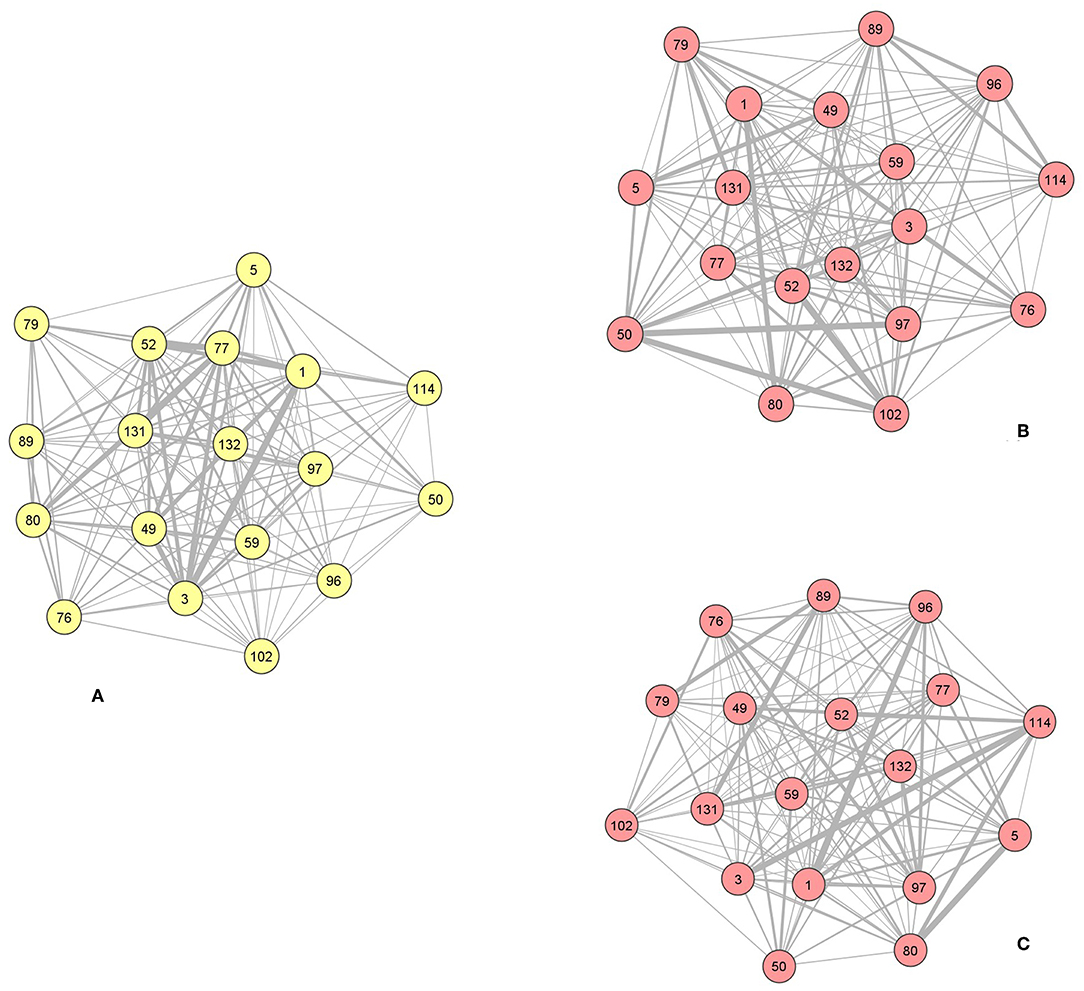
Figure 3. Example of the process of network randomization through link reshuffling. Middle network (A observed, B,C reshuffled).
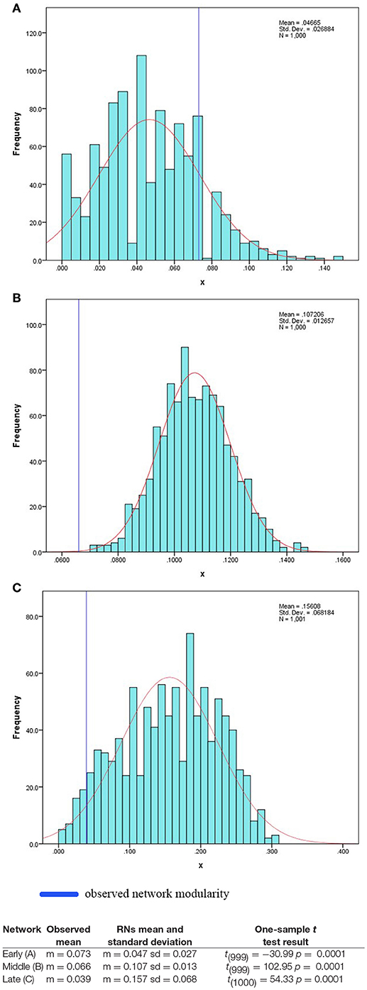
Figure 4. Frequencies of RNs Louvain maximum modularity scores compared to the result obtained on the three empirical networks (A early network; B middle network, C late network). The blue vertical line marks the modularity value calculated on the observed early, middle and late networks. The Qmax value of the early buildings network appears to be statistically significantly higher than the mean of the distribution of the RNs modularity, in contrast both the Qmax score of the observed middle and late networks are significantly lower than the mean of the RN Qmax distributions.
In order to investigate further the modularity results, specifically the assignment of buildings to modules and to verify whether these differ from random, a new set of random networks (100) were generated using a similar process of network edge re-sampling (R–tnet package). The probability that couple of buildings are assigned to the same communities in RNs and in the observed networks is, then, estimated using the assortativity measure on weighted networks (R–assortnet package) (Newman, 2003b; Farine, 2014; Shizuka et al., 2014).
Assortativity has been used to measure the robustness of community structure and quality of sampling strategy in animal societies (Farine, 2014; Shizuka et al., 2014; Shizuka and Farine, 2016). For the purpose of this research assortativity gave us a measure of the similarity of the dyadic associations of buildings to partitions in the empirical network to the one obtained if the network is randomized. Assortativity, in its weighted version, is a value that ranges from 0 to 1, with 1 being the perfect coincidence of buildings to partitions in the RNs and in the observed network and 0 when the attributions are fully divergent (Farine, 2014; Shizuka et al., 2014). In order to obtain assortativity values for the created networks (early and middle) a new matrix was created where 1 is assigned every time dyads of buildings are found in the same community in the 100 replica networks. The membership to modules is then compared to the one of the empirical networks and assortativity calculated.
Results
Early Levels (7100–6700 BC)
The early levels network is formed by eight buildings (Table 3; Figure 5) confined in a restricted geographical area in the central part of the South Area (Figure 1). The South Area is the part of the East Mound that was originally excavated by James Mallaart during the 1960s (Mellaart, 1963, 1964, 1966, 1967) and that was reopened by the ÇRP at the beginning of the 1990s. The early network is, therefore, mainly formed of buildings that have been partially excavated by Mellaart and more recently completed by the ÇRP (B.18, B.43, B.23, and B.2). Additionally, almost all of them, but B.2, are part of deep sequences of overlapping reconstructed buildings whose excavation has been, for the most part, carried out in the 1960s (B.17, B.6, B.24, S.10; B.18, B.16, B.7, B.20, S.8; B.23, B.22, B.21, B.8, S.1) (Farid, 2007a,b,c,d; Hodder, 2007). Of these long sequences the buildings included in the early network have been attributed to three levels (South J, South K, and South L) (Table 3) (Farid, 2014a; Hodder and Farid, 2014). They are B.18 and B.23 that are contemporary abutting and communicating buildings that lay directly above the early penning area (enclosed area where very likely animals were kept) revealed through the 1990s deep sounding (Sp.181) (Cessford, 2007), and the two overlapping buildings B.17, B.6. B.17, is similarly to B.18 laying to a possible penning space (Sp.620) (Taylor, 2017). Furthermore, part of the early network is the B.43, B.160, and B.161 sequence fully excavated by the ÇRP in recent years (Farid, 2014b; Taylor, 2017) and B.2 that differently from the other buildings, was constructed over a midden area and never rebuilt (Farid, 2007b).
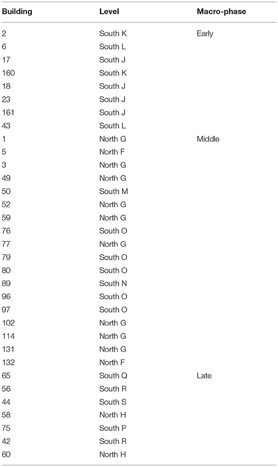
Table 3. Early, middle, and late network buildings.
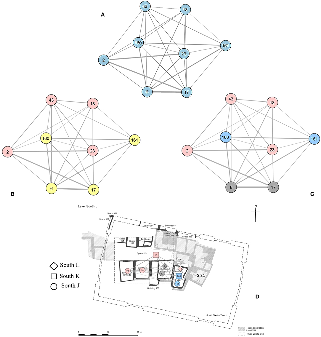
Figure 5. Early network (A). Louvain algorithm partition: layer 1 (B) and layer 2 (C). Early network overlapped to the South Area excavation map (South L) (D).
Modularity
The Louvain method of modularity maximization performed in Visone on the weighted early network yielded results on two levels. The first level, that corresponds to the global maximum, is constituted of two clusters (Figure 5B) and the second one which represents the intermediate step in the process of community decomposition, is formed by three modules (Blondel et al., 2008; Figure 5C). The observed early network obtained a very low modularity score (Qmax = 0.073) (Figure 4A) that, given the highly interconnected nature of the Çatalhöyük early data is not an unexpected result. The very low QEmax speaks to the overall high degree of connectivity of the early buildings and to the weak pattern of community association and structure. The algorithmically extracted communities are very interconnected between themselves. The very low modularity value is matched by an assortativity value of 0, which means that if we create random networks equivalent to our observed one, we perform modularity maximization on them and compare the probability that couple of buildings belong to the same partition in the RN and in the empirical one, we almost never get the same result value. Therefore, the observed co-presence of buildings in communities differ substantially from the attribution to partitions in RN.
The first step of the analysis returned two modules (Figure 5B–yellow and pink module) that divide the network into two blocks of buildings B.161, B160, B.6, and B.17 (Figure 5B–yellow module) and buildings B.43, B.18, B23, and B.2 (Figure 5–pink module). The second layer, which is the intermediate step in the modularity maximization appears to provide a good representation of the data and it is made of three modules: the pink module is the same as the previous maximum modularity level, while the yellow one is now divided into two communities (blue and gray modules) formed by couples of overlapping buildings (B.6–B.17 and B.160–B.161). When observing the distribution of material assemblages in the early 2-mode network and in the materials network (Figures 6A–C) it can be observed that the pink module is characterized by the repeating of specific practice: the location of ovens in the south west corner of buildings together with the presence of underfloor obsidian hoards, the location of burials in the oven area and the quite widespread abandonment practice of putting a projectile point in the pits obtained by the removal of the building posts.
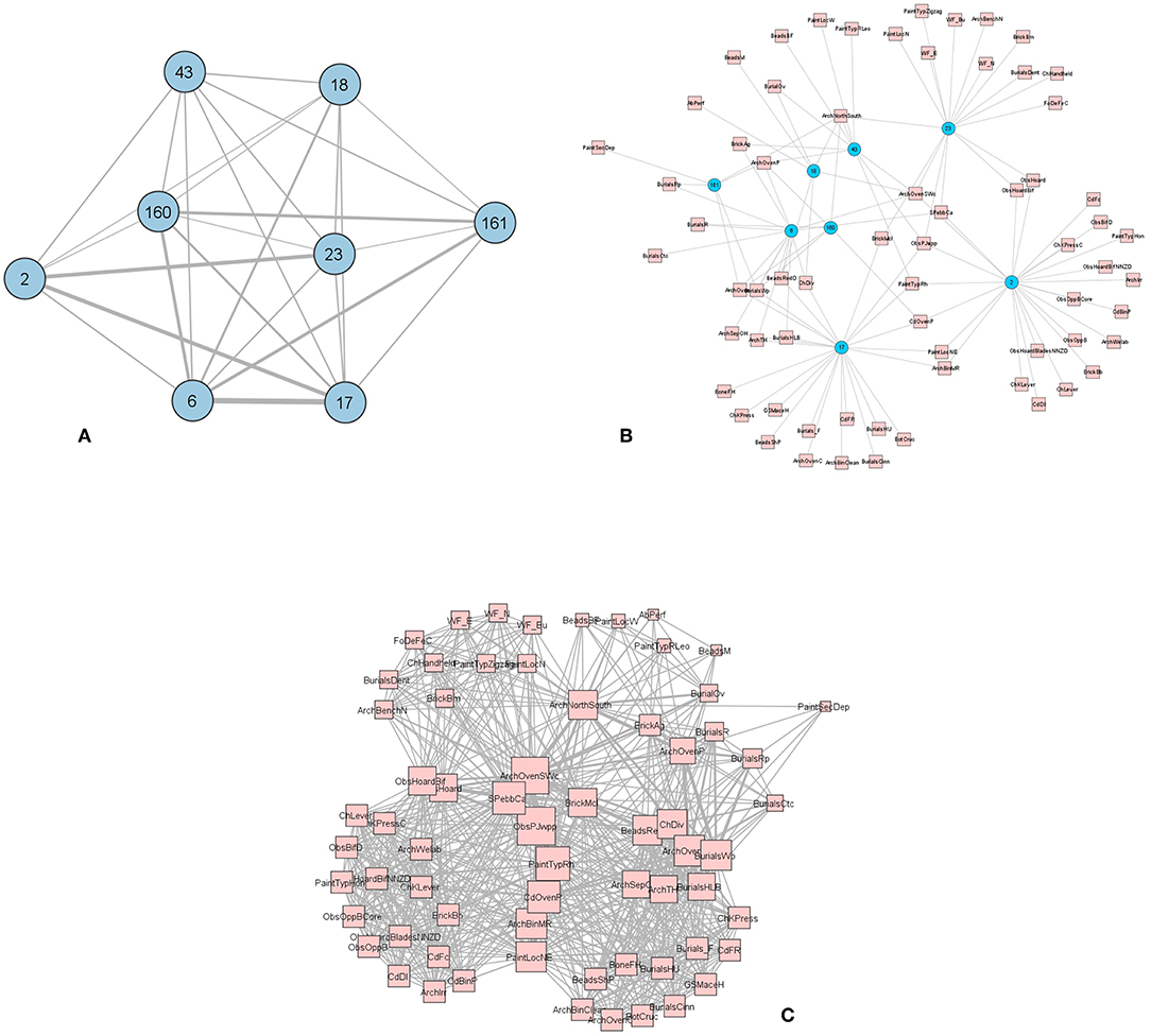
Figure 6. Early network of buildings (A), 2-mode early network (B), and early network of objects (C) (The codes used are in the Supplementary Material).
Similarly, the yellow community is defined by recurring practices: the location of a protruding oven in the northeast area of the building, the presence of unusual burial practices, such as including a wooden plank either above or below the body, or the use of pigment, or the presence on the body of a vast amount of small digested rodent bones that were probably introduced in the burials as carnivore scat (Jenkins, 2012). The intermediate modularity layer provides the opportunity to further investigate the yellow module, which is divided at this stage of the analysis into pairs of overlapping buildings: B.161 and B.160, and B.17 and B.6, both share the same footprints and are part of a deep sequence of rebuilds.
Geographical patterns are difficult to observe in this network, nevertheless, it should be noted that in building S.VIII.31 (Figure 5C), the “red shrine” excavated by Mellaart in the 1960s (Mellaart, 1966. p. 180), and abutting to the right the stack of buildings B.43, B.160, and B.161 and possibly contemporary with B.43, shows some of the material associations that define the yellow module that are very rare on site (wooden plank, microfauna, or red pigment in burials). These sets of material practices seem then to define a group of buildings that cluster in space. Regarding the attribution of B.43 to the pink community, it should be said that this building, partially excavated by Mellaart as S.VII.27 and left exposed to erosion for a long before being completely excavated by the ÇRP, is a difficult building that weakly connects to the other ones.
Middle Levels (6700–6500 BC)
The middle levels at Çatalhöyük are a group of quite homogeneous levels that represent what could be called “classical” Çatalhöyük with its characteristic explosion of symbology within houses. This chronological slice predates the 6500 B.C. period that marks one of the most clearly manifested and widely observed social change at the site (Hodder, 2014a,b). The middle network is made of 18 nodes (Table 3; Figure 7); it is the biggest of the networks under study in terms of both number of nodes and amount of material. Whereas, the early network was spatially constrained to the South Area, the middle one spreads over the South and North Areas and chronologically spans through five levels (Figure 7C). The middle network is almost completely composed of buildings that have been excavated by the ÇRP, seven of which have been fully excavated. Despite its extent, it is the denser and the most uniform of the networks generated and many of the richest in burials and most elaborated buildings that have been studied by the ÇRP are included within this network (e.g., B.1, B.49, B.52, or B.77). The middle network expands mainly horizontally and differently from the early network, few are the sequences of overlapping buildings present, the only exceptions being B.1 and B.5 and B.77 that was, even if much smaller in size, constructed over the earlier B.132. The lack of depth of the network is due to the excavation strategy that was designed to investigate the widest part possible of the site.
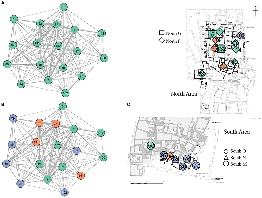
Figure 7. Middle network (A). Louvain algorithm partition (B) and middle network overlapped to the South and North Area excavation map (South O – North G) (C).
Modularity
Within the middle network the Louvain algorithm detected one community level made of three distinctive modules (purple, green, and orange modules–Figure 7B). The overall modularity maximum is very low (Qmax = 0.066), significantly lower than expected by chance (Figure 4B). The middle network is a dense and highly interconnected network and, similarly to the early network, the very low value of Qmax is not unexpected. The low modularity value is matched by a very low assortativity value (0.024). Similarly to the early network the observed co-presence of buildings in communities differ substantially from the RNs partitions.
The green module (Figures 7, 8) is the biggest of the three modules and includes 44% of all the nodes in the network. It is geographically centered in the North Area (B.1, B.3, B.5, B.49, B.59, B.132, and B. 114) but one of its nodes (B.50) is situated in the South Area. B.5 is constructed over the footprint of B.1, this is the only overlapping buildings belonging to the same module of the middle network. If we analyze the materials that link these buildings together (Figures 8B,C) we notice that the buildings of the green group share groups of practices: a preference for the location of the highest platform and the burial platform in the northwestern corner of the building, the presence of sub-floor obsidian hoards and of headless bodies in burials. The green module is additionally characterized by a high diversity of chert sources in buildings. B.50 in the South Area connects to the core of the module in the North Area through the shared presence of bird bones in burials and crane bones in the building together with the occurrence of sub-floor obsidian hoards.

Figure 8. Middle network green module (A). 2-mode network (B – size of nodes according to degree centrality) and object network (C) (The codes used are in the Supplementary Material).
The orange module is also centered in the North Area (Figures 7, 9) and is composed of four buildings (B.77, B.131, B.52, and B.96) one of which (B.96) situated in the South Area. If we look at the material assemblages (Figure 9B,C) that keep buildings together in this community, we observe a preference for situating the highest burial platform in the northeast part of the building, all three North Area buildings are burnt and they share a preference for using peas as a legume. B.96 links to the North Area through similar mural painting motifs and burial practices such as the presence of isolated crania in building and a secondary deposition type that remain quite rare on site.
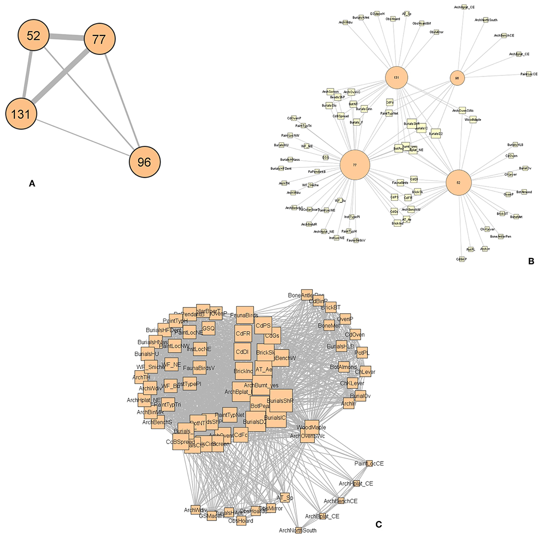
Figure 9. Middle network orange module (A). 2-mode network (B size of nodes according to degree centrality) and object network (C) (The codes used are in the Supplementary Material).
The third module (purple module) (33%) (Figures 8, 10) is, differently from the other two, centered in the South Area (B.80, B.76, B.79, B89) only B.102 is located in the northwest corner of the North Area (B.102 is however a problematic building and the attribution to this module very dubious). The buildings assigned to the purple module stretch over three levels: South O/North G and South N. This South Area module is held together by an array of materials, above all specific architectural features and the burnt status at abandonment (Figures 10B,C).
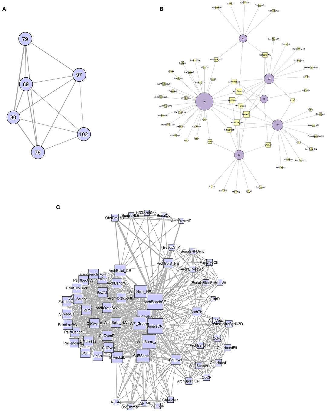
Figure 10. Middle network purple module (A). 2-mode network (B size of nodes according to degree centrality) and object network (C) (The codes used are in the Supplementary Material).
The analysis outlined above highlights several points: first, the middle network is very poorly structured and buildings within it are extensively interconnected and homogeneous in their material assemblages, however the algorithm was able to extract communities that are clearly defined spatially; the three Louvain modules are formed by clusters of buildings adjacent in space. Even so, communities show interconnectivity that cross cut the local community too. Both B.50 and B.96 connect to building in the North Area through a set of practices that in the case of B.50 are obsidian hoards, bird bones, diversity in chert source and specific chert manufacturing technique and in the case of B.96 regard type of mural paintings and specific burial practices like the presence of isolated heads in burials and secondary depositions (Figures 8, 9).
In terms of connectivity the orange and the green modules (North Area) are the most interconnected while the purple module is the most isolated and homogeneous of the three. This may suggest a difference between the North and the South Areas regarding sets of affiliations. The existence of separate communities inhabiting the two northern and southern prominences of the East Mound has been suggested previously on the basis of skeletal traits (Pilloud and Larsen, 2011).
Late Levels (6500–6300 BC)
The late network is the most problematic of the networks generated in this study. It is the smallest of the three (7 nodes) (Table 3; Figures 11A, 12A–C) and it is still in the process of being integrated. All seven buildings that make up the late network have been excavated by the ÇRP and the three overlapping ones (B.44, B.56, and B.65) have been fully excavated. Chronologically it develops through five levels (Table 3; Figure 11C) and geographically it stretches to the North and South Areas (Figure 11C). The late chronological grouping follows the changes that mark the 6500 cal. BC. The core of the network is formed by a highly interconnected stack of building (B.44, B.56, and B.65) that were constructed one on top of the other following a similar architectural footprint. This sequence of buildings represents the perfect example of building continuity at Çatalhöyük. B.75 is the earliest of the buildings in the network and, like B.60, is heavily truncated.
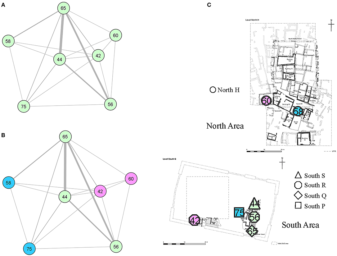
Figure 11. Late network (A). Louvain algorithm partition: layer 1 (B) and layer 2 (C). Early network overlapped to the South Area excavation map.
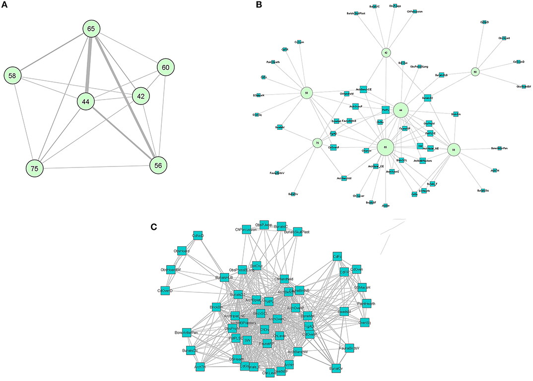
Figure 12. Late network of buildings (A), 2-mode early network (B), and early network of objects (C) (The codes used are in the Supplementary Material).
Modularity
The community detection algorithm returned one layer formed of three communities (Figures 11B,C). As it will be discussed later the late network modules are not made of clusters of proximate buildings but, excluding the higher interconnected light green module (Figure 11B), the other communities are formed by two buildings each, one located in the South and one in the North area (blue module—B.75, B.58 and pink module–B.42 and B.60). The modularity score (Qmax = 0.039) is extremely low as expected (assortativity has not been calculated given the still transitional nature of this network). If we look at the materials that keep the network together, we realize that only the light green module shares a wide number of practices, while the pink module is very weakly interconnected and B.42 and B.60 share only the presence of secondary burials. B.42 is the building where the only plastered skull discovered at Çatalhöyük has been found (Sadarangani, 2013). Buildings in the blue module (B.58 and B.75) similarly share only the presence of the evidence of beads manufacture. Both the blue and the pink networks interact more with the main light green module than between themselves.
Unraveling the Knot: Discussion and Conclusions
Within the field of urban studies, Neolithic megasites have been view primarily as anomalies. While they were vast and densely populated settlements, they lack most of the characteristics that have been linked to the classic definition of “urbanity” as it appears in the south of Mesopotamia during the 4th millennium. The density and vastness of their occupation, the fact that these sites were able to sustain highly intense social interactions for centuries through fully integrated social, economic, material and “political” practices, still raises important questions and challenges classic linear models of urbanity.
What were the principles of social integration of these large fundamentally egalitarian sites, and what can they tell us about the process of early urbanity? While the developments of the Neolithic period were not standardized but instead represent a long-lasting, polycentric and multifaceted process (Gebel, 2002, 2004; Asouti, 2007; Asouti and Fuller, 2013; Finlayson and Makarewicz, 2017), it is nevertheless the case that the Çatalhöyük dataset provides the opportunity to investigate such questions and offers a glimpse of the mechanisms that promoted and allowed the co-residency of a large amount of people in vast early agricultural settlements.
Based on the results of this research, several conclusions can be made. First, the community detection analysis has highlighted a modularity partition essentially based on spatial proximity. Within the highly interconnected system of networks at Çatalhöyük, the modularity maximization algorithm was able to isolate groups of buildings that were related or were interacting more intensely among themselves than with buildings belonging to other sub-communities; these groups (modules/communities) are made of spatially adjacent buildings. Neighboring buildings are embedded in dense sets of material connections that differentiate them from other clusters of adjacent buildings. It should be remembered that, for the purpose of this study, intensity of interaction is measured in terms of similarities of material culture. Therefore, the modularity decomposition analysis highlights that buildings that look alike in terms of material assemblages and therefore are more intensely connected, are close in space. This is mainly visible in the middle layers where the geographical extent of the network gives us the opportunity of observing it, but it is likewise evident in the early network where communities, nevertheless, are spatially defined and are formed by buildings that are geographically adjacent.
As such, the location of buildings within the site appears to be an important organizing principle at Çatalhöyük. Throughout the duration of the settlement, spatial proximity was very likely to have been promoted actively within the community as a means of organizing social relations and constructing the built environment. A strong commitment to place as a structuring principle is additionally evident in the intense material connections of stacks of overlapping buildings that persists through time. Buildings repeatedly constructed on the footprint of earlier ones are, for the most part, assigned to the same community (only B.43 represents an exception).
Spatial proximity seems to be less of an important settlement-shaping principle in the late levels, although caution is required in the interpretation of the results for this phase given the small sample size. The communities isolated by the algorithm within the late network underscore the strong continuity of connectivity through the three overlapping buildings B.44, B.56, and B.65 and a much sparser geographical communities of buildings. This change in the spatially clustered nature of the algorithmically detected communities might be the result of the less dense built environment that characterizes the end of the East Mound occupation sequence (Hodder, 2013, 2014b; Marciniak et al., 2015). Additionally, the late network is the most fragmented and the least connected of the three constructed networks and when it is binarized most of the nodes get disconnected and almost only the sequence of overlapping buildings (B.44, B.56, and B.65) maintains high connectivity. It should be, however, said that some of the buildings of the TPC, TP, and GDN Areas (Figure 1) that comprise a large part of the excavated late and final Çatalhöyük buildings and that, at this stage of the analysis, couldn't be added, show some repetition of practices that follow a clear geographical pattern (e.g., Baranski et al., 2015; Baranski, 2016). Among these practices it is worthwhile mentioning the habit of inserting an entire pot in the floor in the vicinity of the oven, a practice that is repeated in neighboring buildings B.44, B. 65, B.75, B.42, B.150, B.142, and B.81 and that has not been recorded anywhere else in the site (Yalman et al., 2013; Hodder and Farid, 2014).
Similarities between local groups of buildings have been observed frequently at the site (e.g., Tung, 2013; Yalman et al., 2013; Bogaard et al., 2017) and Hodder (2013, 2014b) lists a vast number of similarities and shared features between nearby buildings; he also suggests that similar groups of buildings might have shared burials location, perhaps within history houses (Hodder, 2014a). Furthermore, neighboring houses show a strong interconnectivity that Hodder (2013, 2014b) refers to possible cooperative practices like herding of animals or hunting of big animals. The same observation is made by Bogaard et al. (2017) when they investigated patterns of legume consumption between adjacent burnt building in the North Area (B.131, B.77, and B.52); in this study they suggest the important role cooperation played in early agricultural societies.
As mentioned previously, the idea of spatially clustering buildings forming neighborhoods as a manner of organizing social relations within the Neolithic dense agglomeration of central Anatolia and beyond, has be suggested before (Düring and Marciniak, 2006; Düring, 2007b, 2013; Hodder and Pels, 2010; Rollefson and Kafafi, 2013). Spatial clustering of structures has been observed at other megasites and not only at Çatalhöyük. For instance, at the 9th millennium Central Anatolian (Cappadocia) site of Aşiklı Höyük buildings were organized in clearly defined neighborhoods divided by small alleys (Özbaşaran, 2011, 2012; Özbaşaran and Duru, 2015). Aşiklı Höyük predates Çatalhöyük and in many ways anticipates same of the features that would appear later in the Konya Plain such as the clustered nature of habitations and the role of continuity in house construction reflecting a strong commitment to place (Düring, 2005, 2011; Özbaşaran, 2011, 2012).
At ‘Ain Ghazal, the best excavated Jordanian megasite, Rollefson (2015) observes that agglomerating houses that appear being occupied by single nuclear families were economically independent, although they probably shared resources within spatially clustered social groups, likely kin-based. Moreover, patterns of habitation based on strong spatial clustering and modular spatial segregation have been observed at other 7th millennium sites like Tell Sabi Abyad (Bernbeck, 2008, 2013; Akkermans, 2013). While modularity at Çatalhöyük is very weak, archaeologists at Tell Sabi Abyad in Syria have discerned a settlement organization based on a sharp spatial segmentation of built structures. It has been suggested that the community at this site and at other large Halaf sites (e.g., Domuztepe, Kazane Hoyuk, or earlier Syrian sites like Tell Mounbatah and El Kerkh) was formed by partially autonomous and kin-based clusters of buildings functioning at the same time but dispersed in the landscape (Akkermans, 2013, 2014). Additionally, it has been possible to observed that within the above-mentioned communities, occupation continually changed and shifted horizontally within the perimeter of the site, creating a vast area of archaeological remains that was however never fully and densely occupied. These fragmented settlements have been able to maintain a strong sense of a united community through their occupation (Akkermans, 2013). This type of habitation has been compared to the later levels at Çatalhöyük in which the settlement becomes less clustered and more dispersed than in earlier periods (Hodder, 2014a). It should be noted that a clear understanding of building contemporaneity and rates of change at Çatalhöyük and other megasites is lacking and that, despite the extensive excavation conducted by the ÇRP, only a fraction of the East Mound stratigraphy has been uncovered (see Akkermans, 2013; Hodder and Farid, 2014; Bernardini and Schachner, 2018).
Some of the adjacent buildings that cluster in the same algorithmically defined community are not contemporary; this is the case, for instance, of B.131 (North Gc) and B.77 (North Gb) in the middle network, or B.132 (North F) and B.1 or B.3 (North G). The groups of buildings detected by the algorithm could point to something different from the presence of tightly clustered neighborhoods on site and on the contrary highlight a more sparse and flexible habitation pattern that was however deeply committed to place and to the repetition of same practices in the same places or the residence of affiliated groups or corporate bodies in the same part of the site. This is evident in the reconstructions of houses in stacks in the same place that represent the persistent search for continuity in social roles and relations and the evidence of history making (Hodder and Pels, 2010; Hodder, 2018; Matthews, 2018).
It should also be said that the groups isolated by the Louvain algorithm could speak to many types of relations between buildings. These groups could be formed by buildings that share a common ancestral affiliation or even a functional affiliation; whichever was the connection between them it had a spatial nature.
Geographical modularity, however, is just part of the story; what is really striking at Çatalhöyük is the level of homogeneity and overall intensity of connectivity throughout the entire site. It should be remembered that all three networks buildings are hugely interconnected and the values of community maximization (Qmax) are extremely low and modularity is very poor. There is a marked sense of an overall site-wide shared community identity which appears to be maintained throughout the entire occupation. The middle network is almost impossible to disentangle given the intensity of connectivity. All three networks display affiliation of buildings through shared practices that cross-cut geographical location and Louvain community assignment and bring different parts and groups together. Some of these “linking” practices seem to be the related with mural painting motives (e.g., B.96–orange module), burial practices are both very restricted (e.g., B.6, B.160, B.162–wooden plank in burials or scat of carnivores in burials) and widespread like the presence of isolated heads (e.g., B.96). These types of site-wide connections seem to fit with the proposed idea of the existence of affiliations between buildings as religious sodalities that were bridging different parts of the mound (Mills, 2014). Undoubtedly, we are seeing different forms of affiliation and corporate identities that must have been multifarious and dynamic and that were interacting at different temporal scales (Cohen, 2000; Benz, 2017; Finlayson and Makarewicz, 2017).
In terms of temporal change, it should be stressed that the early network is the easiest to disentangle; furthermore, marked idiosyncrasies are observable in this network when the materials/practices that connect buildings are analyzed. In contrast, the middle network is more homogeneous, and it is extremely difficult to isolate practices and objects that define specific communities. This variability in the early occupation of the site fits well with the a process of community formation and with the idea of the “community born to keep together multiple identities” and possibly different groups coalescing at Çatalhöyük (Finlayson and Makarewicz, 2017). These different identities appear to be homogenized over time, leading to the high levels of interconnectivity observed during the middle network. Spatial proximity might have been sought in order to facilitate a strong sense of community and social cohesion. Through the dense and complex archaeological datasets Çatalhöyük, the network and modularity analyses conducted in this study have provided the opportunity to “discern… the tracery of a pattern so subtle it could escape the termites' gnawing.”
Author Contributions
The manuscript has been entirely conceived and designed by CM. CM acquired, analyzed, and interpreted the data. CM, additionally, drafted and wrote the final version of the manuscript and CM is, therefore, accountable for all aspects of the work.
Conflict of Interest Statement
The author declares that the research was conducted in the absence of any commercial or financial relationships that could be construed as a potential conflict of interest.
Acknowledgments
I am thankful to Ian Hodder and to all the Çatalhöyük Research Project team members. I am additionally grateful to Francesca Fulminante for inviting me to be part of this Special Issue and for funding the publication of this work. This paper was published thanks to an OPEN-AIRE fellowship granted to Francesca Fulminante for the Marie Slodowska Curie Project 628818 Past-People-Net.
Supplementary Material
The Supplementary Material for this article can be found online at: https://www.frontiersin.org/articles/10.3389/fdigh.2019.00008/full#supplementary-material
References
Akkermans, P. M. M. G. (2013). “Living space, temporality and community segmentation: interpreting late neolithic settlement in Northern Syria,” in Interpreting the Late Neolithic of Upper Mesopotamia, eds O. Nieuwenhuyse, R. Bernbeck, P. M. M. G. Akkermans, and J. Rogash (Turnhout: Brepols), 89–99.
Akkermans, P. M. M. G. (2014). “Late Neolithic at tell Sabi Abyad in perspective,” in Excavations at Late Neolithic Tell Sabi Abyad, Syria the 1994-1999 Field Seasons, eds P. M. M. G. Akkermans, M. L. Brüning, H. O. Huigens, and O. Nieuwenhuyse (Turnhout: Brepols), 247–267.
Akkermans, P. M. M. G., and Verhoeven, M. (1995). An image of complexity-the burnt village at Late Neolithic Sabi Abyad, Syria. Am. J. Archaeol. 99, 5–32. doi: 10.2307/506877
Asouti, E. (2006). “Group identity and the politics of dwelling at Neolithic Çatalhöyük,” in Çatalhöyük Perspectives. Reports from the 1995-99 Seasons, ed I. Hodder (London; Cambridge: British Institute at Ankara and McDonald Institute), 75–91.
Asouti, E. (2007). Beyond the Pre-Pottery Neolithic B interaction sphere. J. World Prehist. 20, 87–126. doi: 10.1007/s10963-007-9008-1
Asouti, E., and Fuller, D. Q. (2013). A contextual approach to the emergence of agriculture in Southwest Asia: reconstructing early Neolithic plant-food production. Curr. Anthropol. 54, 299–345. doi: 10.1086/670679
Bains, R., Vasić, M., Mayer Bar-Yosef, D., Russell, N., Wright, K., and Doherty, C. (2013). “A technological approach to the study of personal ornamentation and social expression at Çatalhöyük,” in Substantive Technologies at Çatalhöyük. Reports from the 2000-2008 Seasons, ed I. Hodder (Los Angeles, CA: Cotsen Institute of Archaeology Press), 331–364.
Baird, D., Fairbairn, A., and Martin, L. (2016). The animate house, the institutionalization of the household in Neolithic central Anatolia. World Archaeol. 49, 753–776. doi: 10.1080/00438243.2016.1215259
Baranski, M. (2016). GDN Research on the Late Neolithic Architecture, Çatalhöyük Archive Report 2016. Available online at: http://www.catalhoyuk.com/archive_reports/2016 (accessed April 30, 2019).
Baranski, M., Nowak, A., Regulska, K., and Saj, M. (2015). GDN Area: Research on Late Neolithic Architecture, Çatalhöyük Archive Report 2015. Available online at: http://www.catalhoyuk.com/archive_reports/2015 (accessed April 30, 2019).
Bayliss, A., Brock, F., Farid, S., Hodder, I., Southon, J., and Taylor, R. E. (2015). Getting to the bottom of it all: a bayesian approach to dating the start of Çatalhöyük. J. World Prehist. 28, 1–26. doi: 10.1007/s10963-015-9083-7
Belfer-Cohen, A., and Goring-Morris, A. N. (2013). “Breaking the mold: phases and facies in the Natufian of the Mediterranean Zone,” in Natufian Foragers in the Levant. Terminal Pleistocene Social Changes in Western Asia, eds O. Bar-Yosef and F. Valla (Ann Arbor, MI: Berghahn Books), 544–561. doi: 10.2307/j.ctv8bt33h.37
Belfer-Cohen, A., and Goring-Morris, N. (2011). Becoming farmers: the inside story. Curr. Anthropol. 52, S209–S220. doi: 10.1086/658861
Belfer-Cohen, A., and Goring-Morris, N. (2017). “Moving around” and the evolution of corporate identities in the late Epipalaeolithic Natufian of the Levant,” in Neolithic Corporate Identities. Studies in Early Near Eastern Production, Subsistence, and Environment 20, eds M. Benz, H. G. K. Gebel, and T. Watkins (Berlin: ex oriente), 81–90.
Ben-Shlomo, D., and Garfinkel, Y. (2009). Shaar Hagolan and new insights on near eastern proto-historic urban concepts. Oxf. J. Archaeol. 28, 189–209. doi: 10.1111/j.1468-0092.2009.00324.x
Benz, M. (2016). Prelude to village life. Environmental data and building traditions of the Epipalaeolithic settlement at Körtik Tepe, Southeastern Turkey. Paleorient 41, 9–30. doi: 10.3406/paleo.2015.5673
Benz, M. (2017). “Changing medialities. Symbols of Neolithic corporate identities,” in Neolithic Corporate Identities. Studies in Early Near Eastern Production, Subsistence, and Environment 20, eds H.-G. K. Gebel, M. Benz, and T. Watkins (Berlin: ex oriente), 135–156.
Benz, M., and Bauer, J. (2013). “Preface,” in The Symbolic Construction of Communities, eds M. Benz and J. Bauer (Berlin: Neo-Lithic), 2–5.
Benz, M., Coşkun, A., Rössner, C., Deckers, K., Riehl, S., and Alt, K. W., et al. (2013). “First evidence of an epipaleolithic hunter -fisher-gatherer settlement at Körti?k Tepe,” in Kazi Sonuclari Toplantisi. 28 Mays - 1 Haziran 2012 Çorum (Çorum: Pegasus), 65–78.
Benz, M., Gebel, H. G. K., and Watkins, T. (2017). “The construction of Neolithic Corporate identities. Introduction,” in Neolithic Corporate Identities, eds M. Benz, H. G. K. Gebel, and T. Watkins (Berlin: ex oriente), 1–7.
Bernardini, W., and Schachner, G. (2018). Comparing Near Eastern Neolithic megasites and Southwestern Pueblos: population size, exceptionalism and historical trajectories. Camb. Archaeol. J. 28, 1–17. doi: 10.1017/S0959774318000276
Bernbeck, R. (2008). “An archaeology of multi-sited communities,” in The Archaeology of Mobility. Old World and New World Nomadism, eds W. Wendrich and H. Barnard (Los Angeles, CA: Cotsen Institute of Archaeology), 43–77.
Bernbeck, R. (2013). “Multisited and modular sited in the halaf tradition,” in Interpreting the Late Neolithic of Upper Mesopotamia, eds O. Nieuwenhuyse, R. Bernbeck, P. M. M. G. Akkermans, and J. Rogash (Turnhout: Brepols), 51–61.
Bienert, H.-D. (2001). “The Pre-Pottery Neolithic B (PPNB) of Jordan: a first step towards proto-urbanism?,” in Studies in the History and Archaeology of Jordan VII (Amman: Department of Antiquities Amman – Jordan), 107–119.
Blondel, V. D., Guillaume, J. L., Lambiotte, R., and Lefebvre, E. (2008). Fast unfolding of communities in large networks. J. Stat. Mech. Theory Exp. 10, 1–12. doi: 10.1088/1742-5468/2008/10/P10008
Bogaard, A. (2015). “Communities,” in The Cambridge World History. World with Agriculture 12,000 BCE - 500 CE, eds G. Barker and C. Goucher (Cambridge: Cambridge University Press), 124–160.
Bogaard, A. (2017). “Neolithic “Cooperatives”: assessing supra-household cooperation in crop production at Çatalhöyük and beyond,” in Neolithic Corporate Identities. Studies in Early Near Eastern Production, Subsistence, and Environment 20, eds H.-G. K. Gebel, M. Benz, and T. Watkins (Berlin: ex oriente), 117–134.
Bogaard, A., Filipović, D., Fairbairn, A., Green, L., Stroud, E., and Fuller, D., et al. (2017). Agricultural innovation and resilience in a long-lived early farming community: the 1,500-year sequence at Neolithic to early Chalcolithic Çatalhöyük, central Anatolia. Anatol. Stud. 67, 1–28. doi: 10.1017/S0066154617000072
Bogaard, A., and Isaakidou, V. (2010). “From mega-sites to farmsteads: community size, ideology and the nature of early farming landscapes in Western Asia and Europe,” in Landscapes in Transition: Understanding Hunter-Gatherer and Farming Landscapes in the Early Holocene of Europe and Levant, eds B. Finlayson and G. Warren (London: Levant Supplementary Series & CBRL), 197–207.
Bogaard, A., Michael, C., Katheryn, C. T., Andrew, F., Nurcan, Y., and Dragana, F., et al. (2009). Private pantries and celebrated surplus: storing and sharing food at Neolithic Çatalhöyük, Central Anatolia. Antiquity 83, 649–668. doi: 10.1017/S0003598X00098896
Borgatti, S. P., and Everett, M. G. (1997). Network analysis of 2-mode data. Soc. Netw. 19, 243–269. doi: 10.1016/S0378-8733(96)00301-2
Borgatti, S. P., Everett, M. G., and Johnson, J. C. (2013). Analyzing Social Networks. London: Sage.
Borgatti, S. P., Mehra, A., Brass, D. J., and Labianca, G. (2009). Network analysis in the social sciences. Science 323, 892–896. doi: 10.1126/science.1165821
Boyd, B. (2005). Reassessing the emergence of village life in the Near East. J. Archaeol. Res. 13, 231–290. doi: 10.1007/s10814-005-3107-2
Brandes, U., Delling, D., Gaertler, M., Görke, R., Hoefer, M., and Nikoloski, Z., et al. (2007). “On finding graph clustering with maximum modularity,” in Graph-Theoretic Concepts in Computer Science, eds A. Brandstädt, D. Kratsch, and H. Müller (Berlin: Springer), 121–132.
Brandes, U., Robins, G., McCranie, A., and Wasserman, S. (2013). What is network science? Netw. Sci. 1, 1–15. doi: 10.1017/nws.2013.2
Brandes, U., and Wagner, D. (2004). “Visone - analysis and visualization of social networks,” in Graph Drawing Software, eds M. Junger and P. Mutzel (Springer Verlag), 321–340.
Brughmans, T. (2010). Connecting the dots: towards archaeological network analysis. Oxf. J. Archaeol. 29, 277–303. doi: 10.1111/j.1468-0092.2010.00349.x
Brughmans, T. (2013). Thinking through networks: a review of formal network methods in archaeology. J. Archaeol. Method Theory 20, 623–662. doi: 10.1007/s10816-012-9133-8
Brughmans, T., Collar, A., and Coward, F. (2016). “Network perspectives on the past: tackling the challenges,” in The Connected Past. Challenges to Network Studies in Archaeology and History, eds T. Brughmans, A. Collar, and F. Coward (Oxford: Oxford University Press), 3–19.
Carter, T., and Milic, M. (2013). “The chipped stone,” in Substantive Technologies at Çatalhöyük. Reports from the 2000-2008 Seasons. Çatalhöyük Research Project Volume 9. British Institute at Ankara Monograph 31, ed I. Hodder (Los Angeles, CA: Cotsen Institute of Archaeology Press), 417–478.
Cessford, C. (2007). “Level Pre-XII.E-A and Levels XII and XI, Spaces 181, 199 and 198,” in Excavating Çatalhöyük: South, North and KOPAL Area Reports from the 1995-99 Seasons. Çatalhöyük Research Project Volume 3. British Institute for Archaeology at Ankara Monograph 37, ed I. Hodder (Cambridge: McDonald Institute for Archaeological Research), 59–102.
Chapman, J. (2010). “Houses, households, villages, and proto-cities in Southeastern Europe,” in The Lost World of Old Europe. The Danube Valley, 5000-3500 BC, ed D. W. Anthony (Princeton, Oxford: Princeton University Press), 75–89.
Chapman, J., Videiko, M. Y., Hale, D., Gaydarska, B., Burdo, N., and Rassmann, K., et al. (2014). The second phase of the Trypillia mega-site methodological revolution: a new research agenda. Eur. J. Archaeol. 17, 369–406. doi: 10.1179/1461957114Y.0000000062
Childe, G. (1950). The urban revolution. Town Plann. Rev. 21, 3–17. doi: 10.3828/tpr.21.1.k853061t614q42qh
Collar, A., Coward, F., Brughmans, T., and Mills, B. J. (2015). Networks in archaeology: phenomena, abstraction, representation J. Archaeol. Method Theory 22, 1–32. doi: 10.1007/s10816-014-9235-6
Croft, D. P., Madden, J. R., Franks, D. W., and James, R. (2011). Hypothesis testing in animal social networks. Trends Ecol. Evol. 26, 502–507. doi: 10.1016/j.tree.2011.05.012
Csardi, G., and Nepusz, T. (2006). The igraph software package for complex network research. InterJ. Complex Syst. 1695, 1–9.
Demirergi, A., Twiss, K. C., Boogaard, A., Green, L., Ryan, P., and Farid, S. (2014). “Of bins, basins and banquetes: storing, handling and sharing at Neolithic Çatalhöyükitle,” in Integrating Çatalhöyük. Themes from the 2000-2008 Seasons. Çatalhöyük Research Project Volume 10. British Institute at Ankara Monograph 49, ed I. Hodder (Los Angeles, CA: Cotsen Institute of Archaeology Press), 91–108.
Der, L., and Issavi, J. (2017). The urban quandary and the “mega-site” from the Çatalhöyük perspective. J. World Prehist. 30, 189–206. doi: 10.1007/s10963-017-9103-x
Düring, B. S. (2005). Building continuity in the Central Anatolian Neolithic: exploring the meaning of buildings at Aşikli Höyük and Çatalhöyük. J. Mediterr. Archaeol. 18, 3–29. doi: 10.1558/jmea.v18i1.3
Düring, B. S. (2006). Constructing Communities: Clustered Neighbourhood Settlements at the Central Anatolian Neolithic, ca. 8500-500 Cal. BC. Leiden: Nederland Instituut voor het Nabije Oosten.
Düring, B. S. (2007a). “The articulation of houses at Neolithic Çatalhöyük, Turkey,” in The Durable House: House Society Models in Archaeology, ed R. A. Beck (Carbondale, IL: Southern Illinois University), 130–153.
Düring, B. S. (2007b). Reconsidering the Çatalhöyük community: from households to settlement systems. J. Mediterr. Archaeol. 20, 130–153. doi: 10.1558/jmea.v20i2.155
Düring, B. S. (2011). “Millenia in the middle? Reconsidering the Chalcolithic of Asia Minor. 8000-323 BC,” in Oxford Handbook of Anatolian Studies, 8000-323 BC, eds S. Steadman and G. McMahon (Oxford: Oxford University Press), 796–812.
Düring, B. S. (2013). “The anatomy of a Prehistoric community. Reconsidering Çatalhöyük,” in From Prehistoric Villages to Cities. Settlement Aggregation and Community Transformation, ed J. Birch (New York, NY, London: Routledge), 23–43.
Düring, B. S., and Marciniak, A. (2006). Households and communities in the central Anatolian Neolithic. Archaeol. Dialog. 12, 165–176. doi: 10.1017/S138020380600170X
Farid, S. (2007a). “Introduction to the South Area Excavations,” in Excavating Çatalhöyük: South, North and KOPAL Area Reports from the 1995-1999 Seasons. Çatalhöyük Research Project Volume 3. British Institute for Archaeology at Ankara Monograph 37, ed I. Hodder (Cambridge: McDonald Institute for Archaeological Research), 41–58.
Farid, S. (2007b). “Level IX relative heights, building 2, buildings 22 & 16 and building 17,” in Excavating Çatalhöyük: South, North and KOPAL Area Reports from the 1995-1999 Seasons. Çatalhöyük Research Project Volume 3. British Institute for Archaeology at Ankara Monograph 37, ed I. Hodder (Cambridge: McDonald Institute for Archaeological Research), 139–226.
Farid, S. (2007c). “Level VIII: space 161, space 162, building 4, space 115, buildings 21 & 7, building 6 and relative heights of level VIII,” in Excavating Çatalhöyük: South, North and KOPAL Area Reports from the 1995-99 Seasons. Çatalhöyük Research Project Volume 3. British Institute for Archaeology at Ankara Monograph 37, ed I. Hodder (Cambridge: McDonald Institute for Archaeological Research), 227–282.
Farid, S. (2007d). “Level VII: space 113, space 112, space 105, space 109, building 40, space 106, spaces 168 & 169, buildings 8 & 20, building 24 and relative heights of level VII,” in Excavating Çatalhöyük: South, North and KOPAL Area Reports from the 1995-99 Seasons. Çatalhöyük Research Project Volume 3. British Institute for Archaeology at Ankara Monograph 37, ed I. Hodder (Cambridge: British Institute at Ankara, McDonald Institute for Archaeological Research), 283–338.
Farid, S. (2014a). “Timelines. Phasing Neolithic Çatalhöyük,” in Çatalhöyük Excavations. The 2000-2008 Seasons. Çatalhöyük Research Project Volume 7. British Institute for Archaeology at Ankara Monograph 46, ed I. Hodder (Los Angeles, CA: Cotsen Institute of Archaeology Press), 91–130.
Farid, S. (2014b). “Building 43,” in The 2000-2008 Seasons. Çatalhöyük Research Project Volume 7. British Institute for Archaeology at Ankara Monograph 46, ed I. Hodder (Los Angeles, CA: Cotsen Institute of Archaeology Press), 221–228.
Farine, D. R. (2014). Measuring phenotypic assortment in animal social networks: weighted associations are more robust than binary edges. Anim. Behav. 141–153. doi: 10.1016/j.anbehav.2014.01.001
Farine, D. R. (2017). A guide to null models for animal social network analysis. Methods Ecol. Evol. 8, 1309–1320. doi: 10.1111/2041-210X.12772
Finlayson, B., and Makarewicz, C. (2017). “The construction of community in the early Neolithic of Southern Jordan,” in Neolithic Corporate Identities, eds M. Benz, H.-G. K. Gebel, and T. Watkins (Berlin: ex oriente), 91–106.
Flannery, K. V. (1972). “The origins of the village as a settlement type in Mesoamerica and the Near East: a comparative study,” in Man, Settlement and Urbanism eds P. J. Ucko, R. Tringham, and G. W. Dimbleby (Cambridge: Schenkman Publishing Company), 23–54.
Flannery, K. V. (2002). The origins of the village revisited: from nuclear to extended households. Am. Antiquity 67, 417–433. doi: 10.2307/1593820
Fletcher, R. (1995). The Limits of Settlement Growth: A Theoretical Outline. Cambridge: Cambridge University Press.
Fortunato, S. (2010). Community detection in graphs. Phys. Rep. 486, 75–175. doi: 10.1016/j.physrep.2009.11.002
Fortunato, S., and Barthélemy, M. (2007). Resolution limit in community detection. PNAS. 104, 36–41. doi: 10.1073/pnas.0605965104
Fortunato, S., and Hric, D. (2016). Community detection in networks: a user guide. Phys. Rep. 659, 1–44. doi: 10.1016/j.physrep.2016.09.002
Gaydarska, B. (2016). The city is dead! Long live the city! Norw. Archaeol. Rev. 49, 40–57. doi: 10.1080/00293652.2016.1164749
Gaydarska, B. (2017). Introduction: European prehistory and urban studies. J. World Prehistory 30, 177–188. doi: 10.1007/s10963-017-9104-9
Gebel, H.-G. K. (2002). “The Neolithic of the Near East. An essay on a “Polycentric Evolution” and other current research problems,” in Material Culture and Mental Spheres. Internationales Symposium für Hans J. Nissen Berlin, 23.-24. Juni 2000, ed H. L. Nissen (Münster: Ugarit-Verlag), 313–324.
Gebel, H.-G. K. (2004). “Cetral to what? the centrality issue of the LPPNB mega-site phenomena in jordan,” in Central Settlements in Neolithic Jordan. Proceedings of a Symposium Held in Wadi Musa, Jordan, 21st–25th of July, 1997, eds H.-D. Bienert, G. K. Gebel, and R. Neef (Berlin: Ex Oriente), 1–19.
Giomi, E., and Peeples, M. A. (2019). Network analysis of intrasite material networks and ritual practice at Pueblo Bonito. J. Anthropol. Archaeol. 53, 22–31. doi: 10.1016/j.jaa.2018.10.002
Girvan, M., and Newman, M. E. (2001). Community structure in social and biological networks. Proc. Natl. Acad. Sci. USA. 99, 7821–7826. doi: 10.1073/pnas.122653799
Goring-Morris, A. N., and Belfer-Cohen, A. (2011). Neolithization processes in the Levant. Curr. Anthropol. 52, S195–S208. doi: 10.1086/658860
Goring-Morris, N., and Belfer-Cohen, A. (2010). “Great Expectations”, or the Inevitable Collapse of the Early Neolithic in the Near East,” in Becoming Villagers: Comparing Early Village Societies, eds M. S. Bandy and J. R. Fox (Tucson: University of Arizona Press), 62–77.
Hodder, I. (2005). “Peopling Çatalhöyük and its landscape,” in Inhabiting Çatalhöyük: Reports from the 1995-1999 Seasons. Çatalhöyük Research Project Volume 4, ed I. Hodder (Cambridge: McDonald Institute for Archaeological Research, University of Cambridge), 1–32.
Hodder, I. (2007). “Summary of results,” in Excavating Catalhoyuk: South, North and KOPAL Area Reports from the 1995-1999 Seasons. Catalhoyuk Research Project Volume 3. British Institute for Archaeology at Ankara Monograph 37, ed I. Hodder (Cambridge: McDonald Institute for Archaeological Research), 25–40.
Hodder, I. (2013). “Dwelling at Çatalhöyük,” in Humans and Landscapes of Çatalhöyük Reports from the 2000-2008 Seasons, ed I. Hodder (London; Los Angeles, CA: Cotsen Institute of Archaeology Press), 1–29.
Hodder, I. (2014a). Çatalhöyük: the leopard changes its spots. A summary of recent work. Anatol. Stud. 64, 1–22. doi: 10.1017/S0066154614000027
Hodder, I. (2014b). “Mosaics and networks: the social geography of Çatalhöyük,” in Integrating Çatalhöyük. Themes from the 2000-2008 Seasons. Çatalhöyük Research Project Volume 10. British Institute at Ankara Monograph 49, ed I. Hodder (Los Angeles, CA: Cotsen Institute of Archaeology), 149–168.
Hodder, I. (2015). “Assembling science at Çatalhöyük. Interdisciplinarity in theory and practice,” in Assembling Çatalhöyük, eds I. Hodder and A. Marciniak (Leeds: Maney Publishing), 7–12.
Hodder, I. (2018). “Introduction: two forms of history making in the Neolithic of the Middle East,” in Religion, History, and Place in the Origin of Settled Life, ed I. Hodder (Boulder, CO: University Press of Colorado), 3–32.
Hodder, I., and Farid, S. (2014). “Questions, history of work and summary of results,” in Çatalhöyük Excavations. The 200-2008 Seasons. Çatalhöyük Research Project Volume 7. British Institute at Ankara Monograph 46, ed I. Hodder (Los Angeles, CA: Cotsen Institute of Archaeology Press), 1–51.
Hodder, I., and Mol, A. (2015). Network analysis and entanglement. J. Archaeol. Method Theory 22, 1–29. doi: 10.1007/s10816-015-9259-6
Hodder, I., and Pels, P. (2010). “History house: a new interpretation of architectural elaboration at Catalhoyuk,” in Religion in the Emergency of Civilization: Çatalhöyük as a Case Study, ed I. Hodder (Cambridge: Cambridge University Press), 163–186.
Jenkins, E. (2012). Mice, scats and burials: unusual concentrations of microfauna found in human burials at the Neolithic site of Çatalhöyük. Centr. Anatol. J. Soc. Archaeol. 12, 380–403. doi: 10.1177/1469605312455765
Joyce, R. A. (2015). Transforming archaeology, transforming materiality. Archeol. Pap. Am. Anthropol. Assoc. 26, 181–191. doi: 10.1111/apaa.12064
Knappett, C. (2011). An Archaeology of Interaction: Network Perspectives on Material Culture and Society. Oxford: Oxford University Press.
Knappett, C. (2016). “Networks in archaeology: between scientific method and humanistic metaphor,” in The Connected Past. Challenges to Network Studies in Archaeology and History, eds T. Brughmans, A. Collar, and F. Coward (Oxford: Oxford University Press), 21–33.
I. Kuijt (2000). Life in Neolithic Farming Communities. Social Organization, Identity and Differentiation. New York, NY: Kluwer.
Kuijt, I. (2008). “Demography and storage systems during the Southern Levantine Neolithic The Near Eastern Neolithic Demographic Transition,” in The Neolithic Demographic Transition and its Consequences, eds J.-P. Bocquet-Appel, O. Bar-Yosef (New York, NY: Springer), 287–313.
Kuijt, I. (2018). Material geographies of house societies: reconsidering Neolithic Çatalhöyük, Turkey. Cam. Archaeol. J. 28, 565–590. doi: 10.1017/S0959774318000240
Kuijt, I., and Goring-Morris, N. (2002). Foraging, farming, and social complexity in the Pre-Pottery Neolithic of the southern Levant: a review and synthesis. J. World Prehistory 16, 361–440. doi: 10.1023/A:1022973114090
Lancichinetti, A., and Fortunato, S. (2009). Community detection algorithms: a comparative analysis. Phys. Rev. E 80, 1–11. doi: 10.1103/PhysRevE.80.056117
Lancichinetti, A., and Fortunato, S. (2011). Limits of modularity maximization in community detection. Phys. Rev. E 84:066122. doi: 10.1103/PhysRevE.84.066122
Lusseau, D., Whitehead, H., and Gero, S. (2008). Incorporating uncertainty into the study of animal social networks. Anim. Behav. 75, 1809–1815. doi: 10.1016/j.anbehav.2007.10.029
Marciniak, A. (2015). “The Neolithic house as procurement, production and consumption unit. The case of the late Neolithic at Çatalhöyük,” in Neolithic Diversities. Perspectives from a Conference in Lund, eds K. Brink, S. Hydén, K. Jennbert, L. Larsson, and D. Olausson (Lund: Department of Archaeology and Ancient History, Lund University).
Marciniak, A., Asouti, E, Doherty, C, and Henton, E. (2015). “The nature of household in the upper levels at Çatalhöyük Smaller, more dispersed, and more independent acquisition, production, and consumption unit,” in Assembling Çatalhöyük, eds I. Hodder and A. Marciniak (Leeds: Maney Publishing), 141–165.
Marin, A., and Wellman, B. (2011). “Social network analysis: an introduction,” in The SAGE Handbook of Social Network Analysis, eds J. Scott and P. J. Carrington (London: SAGE), 11–25.
Matthews, W. (2018). “Creating settled life,” in Religion, History, and Place in the Origin of Settled Life, ed I. Hodder (Boulder, CO: University Press of Colorado), 64–98.
Mazzucato, C. (2016). Near urban living: Çatalhöyük and the Late Neolithic megasites. Norwegian Archaeol. Rev. 3652, 1–5. doi: 10.1080/00293652.2016.1170721
Mellaart, J. (1963). Excavations at Catal Höyük, 1962. Second preliminary report. Anatolian Stud. 13, 43–103. doi: 10.2307/3642490
Mellaart, J. (1964). Excavating Çatal Höyük 1963. Third preliminary report. Anatolian Stud. 14, 39–119. doi: 10.2307/3642466
Mellaart, J. (1966). Excavating Çatal Höyük 1965. Forth preliminary report. Anatolian Stud. 16, 165–191. doi: 10.2307/3642483
Menotti, F., and Korvin-Piotrovskiy, A. G. (2012). The Tripolye Culture. Giant-Settlements in Ukraine. Formation, Development and Decline. Oxford: Oxbow Books.
Mills, B. J. (2014). “Relational networks and religious sodalities at Çatalhöyük,” in Religion at Work in a Neolithic Society. Vital Matters, ed. I. Hodder (Cambridge: Cambridge University Press), 159–186.
Mills, B. J. (2016). “Communities of consumption. cusines as constellated networks of situated practice,” in Knowledge in Motion. Constellations of Learning Across Time and Place, eds A. Roddick and A. Stahl (Tucson: University of Arizona Press), 247–270.
Mills, B. J., Peeples, M. A., Aragon, L. D., Bellorado, B. A., Clark, J. J., Giomi, E., and Windes, T. C. 2018. (2018). Evaluating Chaco migration scenarios using dynamic social network analysis. Antiquity 92, 922–939. doi: 10.15184/aqy.2018.86
Mol, A. A. A. (2014). The Connected Caribbean: A Socio-material Network Approach to Patterns of Homogeneity and Diversity in the Pre-colonial Period. Rotterdam: Sidestone Press.
Newman, M. E. (2006). Modularity and community structure in networks. Proc. Natl. Acad. Sci. U.S.A. 103, 8577–8582. doi: 10.1073/pnas.0601602103
Newman, M. E., and Girvan, M. (2004). Finding and evaluating community structure in networks. Phys. Rev. E 69, 1–16. doi: 10.1103/PhysRevE.69.026113
Newman, M. E. J. (2003a). The structure and function of complex networks. SIAM Rev. 45, 167–256. doi: 10.1137/S003614450342480
Newman, M. E. J. (2003b). Mixing patterns in networks. Phys. Rev. E 67:026126. doi: 10.1103/PhysRevE.67.026126
Newman, M. E. J. (2016). Community detection in networks: modularity optimization and maximum likelihood are equivalent. Phys. Rev. E. E94:052315. doi: 10.1103/PhysRevE.94.052315
Oates, J., McMahon, A., Karsgaard, P., Al Quntar, S., and And Ur, J. (2007). Early Mesopotamian urbanism: a new view from the North. Antiquity 81, 585–600. doi: 10.1017/S0003598X00095600
Opsahl, T. (2009). Structure and Evolution of Weighted Networks. University of London Queen Mary College, 104–122. Available online at: https://toreopsahl.com/publications/thesis/
Opsahl, T., and Panzarasa, P. (2009). Clustering in weighted networks. Soc. Netw. 31, 155–163. doi: 10.1016/j.socnet.2009.02.002
Östborn, P., and Gerding, H. (2014). Network analysis of archaeological data: a systematic approach. J. Archaeol. Sci. 46, 75–88. doi: 10.1016/j.jas.2014.03.015
Özbaşaran, M. (2011). Re-starting at Aşikli. Anatolia Antiqua 19, 27–37 doi: 10.3406/anata.2011.1087
Özbaşaran, M. (2012). “The Neolithic on the Plateau,” in The Oxford Handbook of Ancient Anatolia: (10,000-323 BCE), eds G. McMahon and S. Steadman (Oxford: Oxford University Press), 99–125.
Özbaşaran, M., and Duru, G. (2015). “The early sedentary communities of Cappadocia: Aşikli Höyük,” in La Cappadoce Meridionale de la Prehistoire a la Periode Byzantine, eds D. Beyer, O. Henry, and A. Tibet (Istanbul: Institut Français dÉtudes Anatoliennes Georges Dumézil - CNRS USR 3131), 43–51.
Peeples, M., Mills, B. J., Haas, R. J., Clark, J., and Roberts, J. (2016). “Analytical challenges for the application of social network analysis in archeology,” in The Connected Past. Challenges to Network Studies in Archaeology and History, eds T. Brughmans, A. Collar, and F. Coward (Oxford: Oxford University Press), 59–84.
Peeples, M. A., and Roberts, J. M. (2013). To binarize or not to binarize: relational data and the construction of archaeological networks. J. Archaeol. Sci. 40, 3001–3010. doi: 10.1016/j.jas.2013.03.014
Pilloud, M. A., and Larsen, C. S. (2011). ”Official“ and ”practical“ kin: inferring social and community structure from dental phenotype at Neolithic Çatalhöyük, Turkey. Am. J. Phys. Anthropol. 145, 519–530. doi: 10.1002/ajpa.21520
Pollock, S. (2006). “Practices of daily life in fifth-millennium B.C. Iran and Mesopotamia,” in Beyond the Ubaid. Transformation and Integration in the Late Prehistoric Societies of the Middle East. eds R. A. Carter, and G. Philip (Chicago, IL: The Oriental Institute of the University of Chicago), 93–112.
Prignano, L., Morer, I., and Diaz-Guilera, A. (2017). Wiring the past: a network science perspective on the challenge of archeological similarity networks. Front. Digital Human. 4:13. doi: 10.3389/fdigh.2017.00013
Radivojević, M., and Grujić, J. (2018). Community structure of copper supply networks in the prehistoric Balkans: an independent evaluation of the archaeological record from the 7th to the 4th millennium BC. J. Comp. Netw. 6, 106–124. doi: 10.1093/comnet/cnx013
Rollefson, G. (2004). “The character of LPPNB social organization,” in Central Settlements in Neolithic Jordan. Studies in Early Near Eastern Production, Subsistence and Environment 5, eds H.-D. Bienert, G. K. Gebel, and R. Neef (Berlin: ex oriente), 145–154.
Rollefson, G. O. (2010). “Blood loss: realignments in community social structures during the LPPNB of highland Jordan,” in The Principle of Sharing. Segregation and Construction of Social Identities at the Transition from Foraging to Farming, ed. M. Benz (Berlin: ex oriente), 182–202.
Rollefson, G. O. (2015). “Ain Ghazal,” in The Cambridge World History. Volume 2: A World with Agriculture, 12,000 BCE-500 CE. eds G. Barker and C. Goucher (Cambridge: Cambridge University Press), 243–260.
Rollefson, G. O., and Kafafi, Z. A. (2013). “The town ofAin Ghazal,” in Symbols at Ain Ghazal, ed D. Schmandt-Besserat (Berlin: ex oriente), 3–29.
Sadarangani, F. (2013). “The sequence of buildings 53 and 42 and external spaces 259, 260 and 261,” in Çatalhöyük Excavations. The 200-2008 Seasons. Çatalhöyük Research Project Volume 7. British Institute at Ankara Monograph 46, ed I. Hodder (Los Angeles, CA: Cotsen Institute of Archaeology Press), 191–220.
Shizuka, D., Chaine, A. S., Anderson, J., Johnson, O., Laursen, I. M., and Lyon, B. E. (2014). Across-year social stability shapes network structure in wintering migrant sparrows. Ecol. Lett. 17, 998–1007. doi: 10.1111/ele.12304
Shizuka, D., and Farine, D. R. (2016). Measuring the robustness of network community structure using assortativity. Anim. Behav. 112, 237–246. doi: 10.1016/j.anbehav.2015.12.007
Souvatzi, S. (2007). “Social complexity is not the same as hierarchy,” in Socialising Complexity: Structure, Interaction and Power in Archaeological Discourse, eds S. Kohring and S. Wynne-Jones (Oxford: Oxbow Books), 37–59.
Souvatzi, S. (2008). A Social Archaeology of Households in Neolithic Greece. Cambridge: Cambridge University Press.
Souvatzi, S. (2012). “Between the individual and the collective: household as a social process in Neolithic Greece,” in New Perspectives on Household Archaeology, eds B. J. Parker and C. P. Foster (Winona Lake, IN: Eisenbraun), 15–44.
Sterelny, K., and Watkins, T. (2015). Neolithization in Southwest Asia in a context of niche construction theory. Camb. Archaeol. J. 25, 673–691. doi: 10.1017/S0959774314000675
Taylor, J. (2017). Excavation in the South Area, Çatalhöyük Archive Report 2015. Available online at: http://www.catalhoyuk.com/archive_reports/2017 (accessed April 30, 2019).
Tringham, R. (2000). “The continuous house: a view from the deep past,” in Beyond Kinship. Social and Material Reproduction in House Societies, eds R. A. Joyce and S. D. Gillespie (Philadelphia, PA: University of Pennsylvania Press), 115–134.
Tung, B. (2013). “Building with mud: an analysis of architectural materials at Çatalhöyük,” in Substantive Technologies at Çatalhöyük. Reports from the 2000-2008 Seasons. Çatalhöyük Research Project Volume 9. British Institute at Ankara Monograph 31. ed I. Hodder (Los Angeles, CA: Cotsen Institute of Archaeology Press), 67–80.
Ur, J. (2016). Challenges in early urbanism: a view from Mesopotamia. Norw. Archaeol. Rev. 3652, 1–3. doi: 10.1080/00293652.2016.1170724
Ur, J. (2017). “The birth of cities in Ancient West Asia,” in Ancient West Asian Civilization: Geoenvironment and Society in the Pre-Islamic Middle East, eds A. Tsuneki, S. Yamada, and K. Hisada (Singapore: Springer), 133–147.
Ur, J. A. (2014). “Urban form at tell brak across three millennia,” in Preludes to Urbanism: Studies in the Late Chalcolithic of Mesopotamia in Honor of Joan Oates, eds A. McMahon and H. Crawford (Cambridge: McDonald Institute for Archaeological Research and the British School of Archaeology in Iraq), 49–62.
Van Oyen, A. (2016). Historicising material agency: from relations to relational constellations. J. Archaeol. Method Theory 23, 354–378. doi: 10.1007/s10816-015-9244-0
Watkins, T. (2013). “Neolithisation needs evolution as evolution needs neolithisation,” in The Symbolic Construction of Communities. Vol.2, eds M. Benz, J. Bauer, and T. Watkins (Berlin: Neo-lithics), 3–8.
Wengrow, D. (2010). What Makes Civilization? The Ancient Near East and the Future of the West. Oxford: Oxford University Press.
Wengrow, D. (2015). Cities before the State in Early Eurasia (The Jack Goody Lecture 2015). Halle (Saale): Max Planck Institute for Social Anthropology.
Yalman, N., Tarkan, D., and Gültekin, H. (2013). “The Neolithic Pottery of Çatalhöyük: recent studies,” in Substantive Technologies at Çatalhöyük. Reports from the 2000-2008 Seasons. Çatalhöyük Research Project Volume 9. British Institute at Ankara Monograph 31, ed I. Hodder (Los Angeles, CA: Cotsen Institute of Archaeology Press), 147–182.
Yang, Z., Algesheimer, R., and Tessone, C. J. (2016). A comparative analysis of community detection algorithms on artificial networks. Sci. Rep. 6, 1–16. doi: 10.1038/srep30750
Keywords: Neolithic, Çatalhöyük, Near East, network analysis, community detection, cities
Citation: Mazzucato C (2019) Socio-Material Archaeological Networks at Çatalhöyük a Community Detection Approach. Front. Digit. Humanit. 6:8. doi: 10.3389/fdigh.2019.00008
Received: 05 January 2019; Accepted: 17 April 2019;
Published: 09 May 2019.
Edited by:
Francesca Fulminante, University of Bristol, United KingdomReviewed by:
Barbara J. Mills, University of Arizona, United StatesYongquan Fu, National University of Defense Technology, China
Fiona Coward, Bournemouth University, United Kingdom
Copyright © 2019 Mazzucato. This is an open-access article distributed under the terms of the Creative Commons Attribution License (CC BY). The use, distribution or reproduction in other forums is permitted, provided the original author(s) and the copyright owner(s) are credited and that the original publication in this journal is cited, in accordance with accepted academic practice. No use, distribution or reproduction is permitted which does not comply with these terms.
*Correspondence: Camilla Mazzucato, Y2FtaW1henpAc3RhbmZvcmQuZWR1