 Roland Fletcher
- Department of Archaeology, University of Sydney, Sydney, NSW, Australia
The conventional history of urban growth defines agrarian-based cities prior to the nineteenth century CE as densely inhabited and commonly bounded by defenses such as walls. By contrast industrial-based cities are viewed as more spread out and without marked boundaries. Since the 1960s a trajectory toward extensive, low-density urbanism with sprawling, scattered suburbs surrounding a denser core has been formally recognized and given various names such as megalopolis in the West and desakota in southern and eastern Asia. These sprawling industrial cities have been regarded as a unique derivative of modern phenomena such as mechanized transport and the commercial property market. However, this set of premises are not valid. The agrarian-based world also contained dispersed, low-density urbanism—on its grandest scale, the vast circa 1,000 sq km urban complex of Greater Angkor and the famous Maya cities of lowland Central America with maximum areas of about 200 sq km. The Maya only used pedestrian and riverine transport so the conventional transport explanation for industrial dispersed urbanism is at best partial. There was another trajectory to extensive, low-density settlement forms for places which were generally <15–20 sq km in extent but could on rare occasions reach areas as large as 40 to 90 sq km. Famous examples are Great Zimbabwe, Chaco Canyon and the European oppida of the late 1st millennium BCE. No-formally agreed term is available to refer to them. I will refer to them by default as “Giants.” The three trajectories to low-density settlement form redefine the history of settlement growth and the meanings of the term “urban.” Worryingly, none of the successive low-density settlements derive from any of the low-density cases of the preceding trajectory. Neither Angkor nor the Classic Maya cities have any connection to the industrial low-density cities. By contrast compact cities, the epitome of the obsolete definition of cities display continuity to succeeding urban forms over several 1,000 years. The implications for modern, giant, low-density cities are ominous.
Introduction
Since the 1960s a trajectory toward extensive, low-density industrial urbanism with sprawling, scattered suburbs, surrounding a denser core has been formally recognized and given various names such as megalopolis in the West and desakota in southern and eastern Asia (Gottman, 1961; McGee, 1967, 1991; Doxiadēs, 1968; Angel et al., 2005, 2012; Morrill, 2006; Angel, 2012). These sprawling industrial cities (Figure 1) have been regarded as a unique derivative of modern socio-economic phenomena, such as mechanized transport and the commercial property market. The conventional history of urban growth defines agrarian-based cities prior to the nineteenth century CE as densely inhabited and commonly bounded in some way, for example by topographic features or walls. By contrast, large industrial-based cities are viewed as more spread out and lacking marked artificial boundaries.
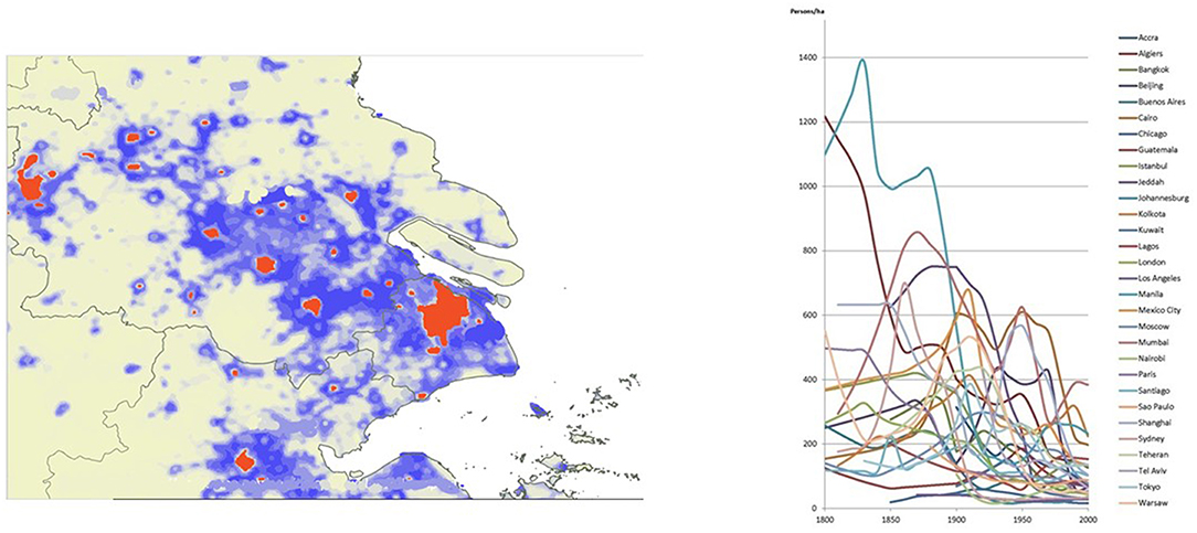
Figure 1. (i) Expansion of Greater Shanghai twentieth–twenty first century. Prepared by Scott Hawken. (ii) Decrease on overall urban densities Nineteenth–twentieth century database—prepared by Kirrily White. Prepared from public domain database (Angel et al., 2016).
However, this set of premises is not valid. The agrarian-based world also contained dispersed, low-density urbanism. On the grandest scale these include the vast urban complex of Greater Angkor (Figure 2; Groslier, 1979; Pottier, 1999; Fletcher et al., 2003; Evans et al., 2007), which at its peak in the twelveth century covered ~1,000 sq km, Anuradhapura and Pollonaruwa in Sri Lanka which ended between the eleventh to thirteenth century CE (Devendra, 1959; Gunawardana, 1971; Coningham and Gunawardhana, 2013) and the famous Classic Maya cities of lowland Central America (Figure 3; Sharer and Traxler, 2006), with maximum areas between 100 and 200 sq km, which faded away in the ninth century CE. The Maya only used pedestrian and riverine transport so the conventional transport innovation explanation for dispersed urbanism in industrial societies is at best partial. The presence of sprawling suburbs in the agrarian cities suggests that the old models of industrial urbanism are both incomplete and potentially problematic. The existence of the agrarian-based, low-density cities also specifies that the low-density pattern is a usual feature of human behavior rather than a unique and anomalous aspect of “strange” industrial urbanism. The extension of that understanding is that there should be other such settlements of varying functions and magnitudes.
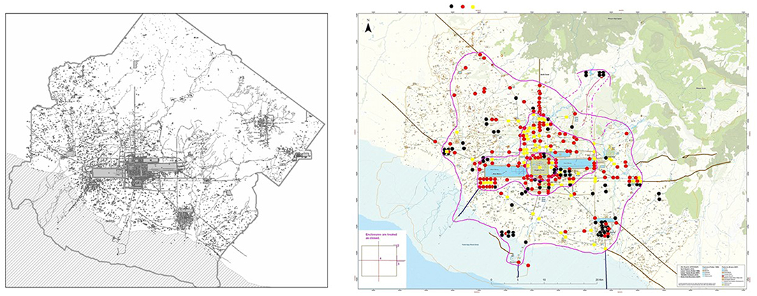
Figure 2. (i) Greater Angkor thirteenth–fifteenth century CE. (Courtesy Evans and Pottier) Map prepared as part of the Greater Angkor Project. (ii) Greater Angkor twelveth–thirteenth century CE. Route network nodes. Prepared by Andrew Wilson.
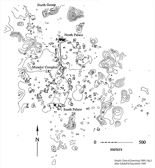
Figure 3. Maya settlement of Sayil, Mexico, Terminal Classic, tenth century CE. Permission to published granted by the copyright holder, the Middle American Research Institute.
Since we know that some hunter-gatherer communities live in extensive dispersed camps (Fletcher 1), as for example, among the Australian Aboriginal communities of the deserts of Australia (Figure 4; O'Connell, 1977; Whitelaw, 1991) and by the Ainu of Hokkaido (Watanabe, 1973), this must be an essentially universal human behavioral characteristic. Conventional agrarian “village” communities, likewise use this settlement form. Large regions of West Africa, inhabited by the Kofyar (McCNetting, 1968), the Tallensi (Figure 5; Fortes, 1945) and the Lobi-Dagati societies (Figure 6; Goody, 1956) among others, are covered by vast dispersed villages where the houses are widely separated and each is surrounded by fields1. A “village,” occupied by one self-defined community, can extend across several kilometers. This form of settlement was also very well-known in some regions of Europe and has featured in settlement pattern geography (Cerne, 2004) at least since the mid twentieth century, for example in Hoskins famous “Making of the English Landscape” (1955).
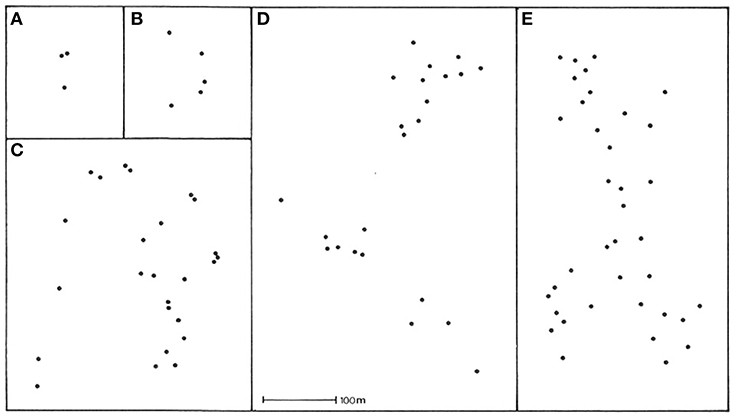
Figure 4. Australian Aboriginal Desert Camps. (A–E) are different camp sites. (Courtesy Todd Whitelaw). Permission to publish granted by the creator and copyright holder Todd Whitelaw.
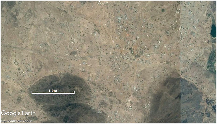
Figure 5. Tongo, Tallensi region, Ghana, 2019.
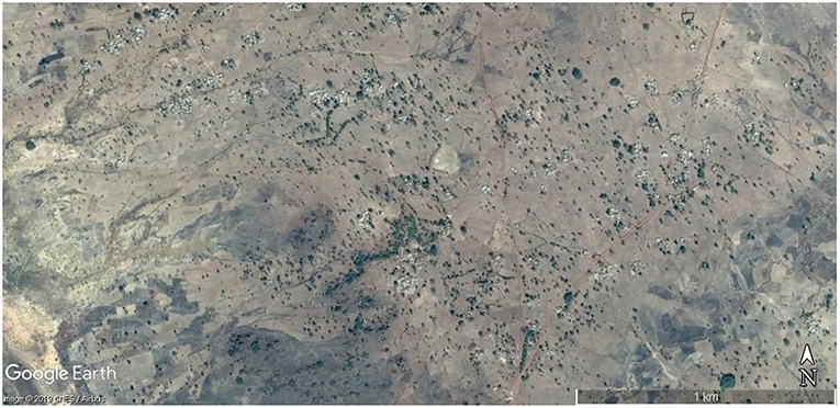
Figure 6. Birifor, Lobi Dagati region Ghana, 2019.
We therefore know of low-density, dispersed settlement forms ranging from several 100,000 sq km, such as the megalopoli, to dispersed hunter-gatherer camps covering several hectares. Just as we have spectacular, giant industrial cities in the range up to more than 100,000 sq km and vast, agrarian urban, low-density cities, covering as much as 100 to a 1,000 sq km we should therefore also have a set of extensive dispersed agrarian-based settlements at the next smallest order of magnitude. We already know that dispersed agrarian “villages” exist with areas larger than a square kilometer. So we should also expect that this magnitude of dispersed settlement would also have produced settlements of proportionately spectacular size and form covering from several sq km to tens of sq km. Famous examples of this third size-range of spread-out settlements (Figure 7) are Great Zimbabwe (Garlake, 1970; Pikirayi and Chirikure, 2011; Chirikure et al., 2016, 2017), Cahokia (Fowler, 1989; Kelly and Brown, 2014; Baires, 2015; Pauketat et al., 2015) and the European oppida of the late 1st millennium BCE (Collis, 1984; Sievers and Schönfelder, 2012; Moore et al., 2013; Poux, 2014). It turns out that some very rare example even range up to 40–70 sq km and perhaps larger (Figure 8) such as Gelonas—a Scythian gorodische (Shramko, 1987, 2012; Murzin et al., 1999; Zöllner et al., 2008) and the vast area of Chaco Canyon (Vivian, 1970; Wills and Dorshow, 2012; Drake et al., 2014; Price et al., 2017) in the SW of North America. As yet no-formally agreed term is available to refer to this class of settlement though some are contentiously called urban or else rejected as urban, either periodically or at the same time. As Taylor remarked of the Tripillya sites (1987, p. 4) are they either “cities” or “just overgrown villages? (see Zbenovich, 1996; Nebbia, 2017)” These kinds of settlements are plainly not “just” villages (Chapman et al., 2014), as a set of dispersed, agrarian villages is already known to exist. These are something more. I have previously called such sites, often with massive constructions or a distinctly ordered spatial layouts, “No-Name” settlements2. More recently they have been referred to as Anomalous Giants. Since they are only anomalous relative to our current restricted “camp-village-urban” taxonomy of settlement form, and not due to some inherent anomalous strangeness of their own, a simple way of referring to them is needed. “Giant” sites, as proposed by Chapman and Gaydarska, may serve as a default for now, because the term avoids a definitive ascription of their role or categorization.
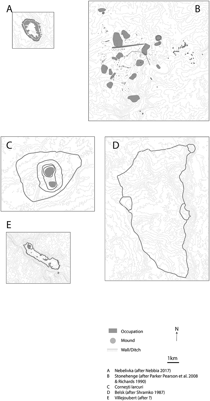
Figure 7. Giant sites compared—Old World. Prepared by Kirrily White.
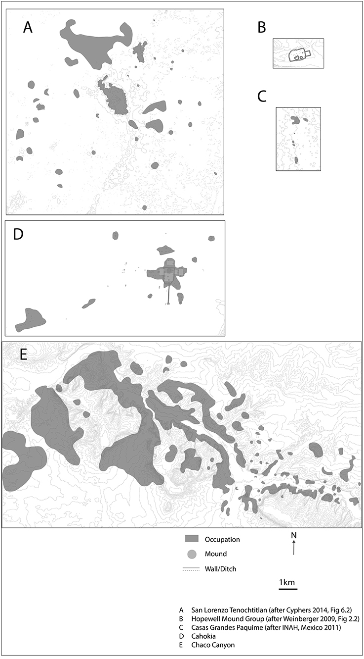
Figure 8. Giant sites compared—New World. Prepared by Kirrily White.
These Giants have not been “seen” as a distinct set of settlements because dispersed occupation settlements in general were not “seen.” This is not a case of data not being known. Rather it is that the compact village has been a very strong normative model of “the village,” despite dispersed villages being known in academic literature since at least the early-mid twentieth century. In addition, the Classic Maya urban dispersed pattern had been seen in the Ricketsons' surveys around Uaxactun in the 1930s (see Black, 1990), was understood in the 1960s once Willey's program of research developed (Willey, 1956, 1965; Sabloff and Fash, 2007) and was formally described by Puleston (1973) for Tikal in the 1970s. This information was available to be combined with the observation of industrial dispersed urbanism to create a new view of what was feasible for urban settlements. But facts do not suffice, in themselves, for the phenomenon they represent to be perceived and understood. The data need to be seen in a larger context which gives them meaning. This can be both a theoretical context and a particularly vivid empirical context, though the empirical context is likely to come about because of a conceptual proposition which directs attention to collecting that contextual data. The form of the “anomalous giants” was not a topic of focus because low-density settlements were not a topic of discussion and the giant agrarian cities which have since directed attention to that topic could not readily be recognized.
Why Were Low-Density Dispersed Agrarian-Based Cities Not Observed?
Compact urbanism was seen as the only form of agrarian-based urbanism by scholars trained in Europe. Their understanding of the Islamic world, Mesopotamia, India, and China strengthened this view. The viewpoint was good common-sense, because European scholars simply did not experience, and nor could they readily “see” any dispersed urban settlements which had predated the later nineteenth and early twentieth century. It was simply self-evident that cities were compact because all known agrarian-based European cities were compact and were delimited in various ways, as were most other cities of the past in the Old World, outside Africa, and also in the Mesoamerican highlands and along the west coast of South America. For the social and intellectual traditions of both India and China the compact, bounded city was normal.
Industrial urbanism could be considered to be different—more spread out—and with a ready explanation of their form in the mechanics of transport, a new economy and the role of the real estate market. Therefore, because cities were “traditionally” compact, modern sprawl was unique and idiosyncratic, and its form was therefore uninformative about the past, and did not lead to the question—were there dispersed low-density urban settlements in the agrarian world? Plainly, industrial cities have to be called urban and are sprawling. They, therefore, could in principle have specified that if they are “urban” then urbanism in general would include dispersed and patchy forms of occupation. But the empirical evidence prior to the 1960s also did not indicate that there was any topic to which that proposition could attach, though Pagan in Myanmar (Figure 9; Pichard, 1995; Hudson, 2004) was a potential exception.
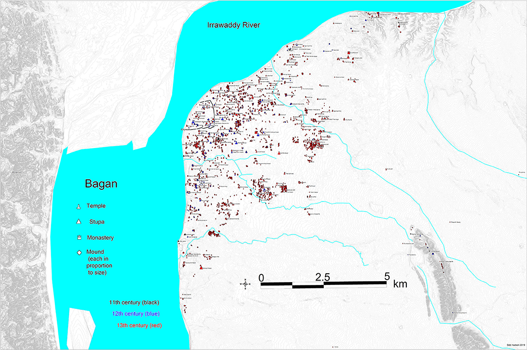
Figure 9. Pagan, Myanmar eleventh–thirteenth century CE. Permission to publish granted by the creator and copyright holder, Bob Hudson.
Most of the large, low-density agrarian cities which we know from archaeology are in primary and secondary tropical forest. In consequence their layout is hard to see. And due to the use of domestic housing built mainly from organics, the residential landscape is not readily apparent in most tropical regions with the exception of the Maya sites where the lightly built houses were raised on stone rubble platforms. The remains of a dispersed urban settlement were therefore generally less likely to be observed by walking through it. In addition, the majority of agricultural, literate, low-density cities had ceased to function and be fully inhabited by the mid-2nd millennium CE before Europeans could see them. And even when a foreign observer saw one—Zhou Daguan being the notable example in 1295-6 in Angkor—he “saw” it, as his own Chinese cultural familiarity would lead him do, as the walled “city” of Angkor Thom, with some huge structures such as Angkor Wat well-beyond the walls (Daguan, 2007). Likewise, for European scholars arriving in the largely abandoned landscape of Angkor in the later nineteenth century, they also saw Angkor Thom and the other great temple enclosures as the equivalent of European medieval towns because they were of similar areal extent (Figure 10).
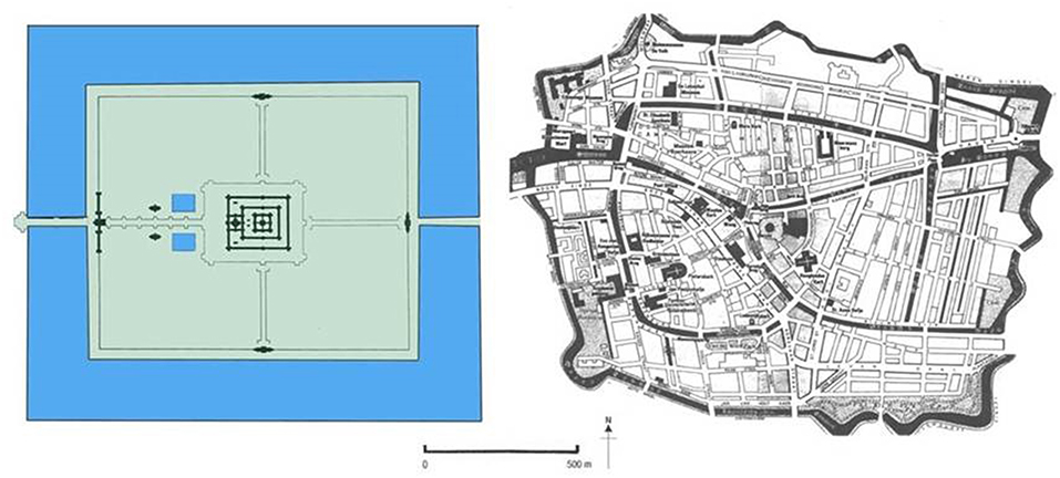
Figure 10. Angkor Wat, Angkor, Cambodia twelfth century CE, compared to sixteenth century Leiden, Netherlands, Europe. Prepared for the Greater Angkor Project by Martin KIng and KIrrily White.
The rare case of Pagan is highly informative about classificatory pre-designation. The clearly visible 90 sq km expanse of dispersed monuments (see Figure 9) which is in an open, dry landscape was viewed simply as a small walled city because of the palatial enclosure near the river, with temples scattered around it. Classificatory expectation had precedence over what could be seen. Likewise, from the 1930s to 60s, the Maya cities were seen as temple clusters isolated in the jungle (Webster, 2007). And when the vast dispersed extent of these cities was empirically recognized the explanatory priority was to legitimate them as relatively “dense” areas of occupation in order to validate their urban status. Only since the spread—out patterns was clearly recognized and had been studied in detail did the focus shift decisively to their open extent (e.g., Sabloff, 1990; Graham, 1999; Isendahl, 2012). Yet until recently they were still regarded as so unusual, globally, that a case to redefine agrarian “urbanism” to include dispersed, low-density form would have had a hard ride. Likewise, at Angkor Groslier had identified the spread-out distribution of occupation and shrines in Angkor by the 1950s and 60s. He published his model of extended suburbs linked together by road embankments and canals in 1979 (Figure 11) as part of a study of the areal expansion of Angkor from the ninth to the fourteenth century. However, this insight did not gain traction either in Angkorian studies or with SE Asian regional specialists. The walled enclosure of Angkor Thom continued to be perceived as the “city” and the prior assumption (Briggs, 1951 for example) that Angkor had just been a succession of small, walled “cities” from at least the ninth century—and also the Goloubew interpretation of CP807 (see Pottier, 2000)—was maintained. No change could occur in interpretation from the 1970s into the 90s because field archaeology was impossible in Cambodia due to severe political crises. New empirical data could not be obtained and foreign archaeologists could not assess reinterpretations of the urban landscape. Only in the 1990s did Christophe Pottier start his PhD research on the landscape of Angkor, following up on Groslier's insight and mapped the southern suburbs of Angkor in detail (1999). He also showed that the mid-ninth century capital of Hariharalaya (modern Rolous) did not have a boundary wall and that the major temple enclosure around the Bakong did not encompass much occupation (Pottier, 2005). Furthermore, he showed that Goloubev's proposition that CP 807 was one corner of a walled city dated to the late ninth century was incorrect (Pottier, 2000; Figure 1) and that the feature was built much later in the history of Angkor. This was made spectacularly apparent in the lidar images from the 2012 survey where it can be readily observed that CP807 postdates Angkor Wat and has no eastern right-angle counterpart (Evans and Fletcher, 2015). None-the-less Gaucher has vigorously continued to view Angkor Thom as the city in its entirely 2004, rather than the “City” as an equivalent of the City of London within Greater London or lower Manhattan within Greater New York.
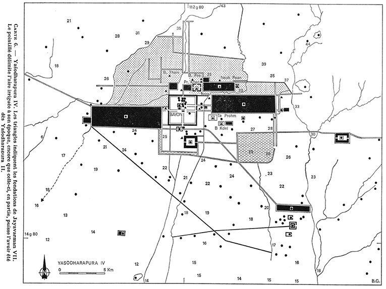
Figure 11. Map by B-P Groslier covering the area of Greater Angkor in the twelfth–thirteenth century CE. Permission to publish granted by the copyright holder, I'École Française d'Extrême-Orient.
What Directed Attention to Low-Density Urbanism?
Pottier's maps, based on the remote sensing images of the FINMAP aerial photographs and his own ground surveys, combined with the validation of Groslier's intellectual status provided the first decisive images of an Asian agrarian-based, dispersed urban complex. His precise arguments about the form of Hariharalaya confronted Angkorian specialists with a debate about urban form, related to a historical process and to the established specification that Hariharalaya was the “model” for Angkor and therefore needed to be addressed. My own arrival in Angkor because of very specific research issue raised by my own theoretical work (see below p. 7–9) triggered collaboration with Christophe and a follow up on the initial space borne and aerial radar surveys of 1994 and 1996 by NASA—JPL. What is significant is that neither of those initial remote sensing radar surveys, in themselves, led the scholarly world to recognize the urban form of Angkor, despite Groslier's work and the paper by Jacques (1978) where he shows an extended North but then does not produce later maps with it marked.
The 1994 survey from the Space Shuttle—courtesy of WMF and NASA (Figure 12) was, however, the empirical trigger for me to conclude that Angkor was indeed a giant low-density city. Up to that time I too had perceived Groslier as somehow describing the landscape of a region. The following, 1996 AIRSAR radar survey did not trigger a re-perception of the form and extent of Angkor because it was a partial strip across the southern half of Angkor and was used by its instigator, Moore (2000), in an erroneous claim that radar was primarily a useful tool for finding undiscovered temples. As a consequence, her focus emphasized isolated specific structures in a landscape, not the relationships which could be clearly seen between sectors of the occupation, the infrastructure and the rice fields of Angkor, as Pottier had emphasized in 1999.
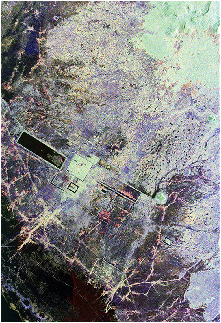
Figure 12. Angkor region 1994. SIR-C radar image from Space Shuttle NASA. (source public domain image NASA JPL).
The basic problem was that the sheer scale of Angkor militated against seeing it as whole and made studying it exceptionally difficult, especially on the ground in areas of either dense ground cover or extensive rice fields, in a region which was extremely wet for half of the year. Aerial photo coverage could give real assistance for surveys but did not in itself offer a vivid visual image of the whole because the coverage was, as was normal, divided into tiles of varying clarity and contrast. The 1994 space radar image did, however, spectacularly cover the whole of the Angkor urban complex, for the first time in one image from the Kulen hills to the lake and from the Puok river to the Damdek canal. The Great North Canal is starkly visible, showing for the first time the full extent of the infrastructure connections to central Angkor3. What followed from the collaboration between the University of Sydney and the EFEO was an international program to carry out a 7,000 sq km GEOSAR survey over Angkor to create the map of the entire area of the Angkor urban complex (see Evans, 2007 and Evans et al., 2007). That presented, in very consistent, recognizable detail and beautiful color the extent, configuration, structure, and economic food source foundations of the entire urban complex of Angkor. Greater Angkor could then be designated (Fletcher et al., 2003), avoiding terminological conflict with those scholars who are primarily and properly focussed on the central area of Angkor—“Angkor” in the usual parlance. A gratifying collaboration developed between Damian Evans and Christophe Pottier to create the digital map of Greater Angkor, its water catchment and the wider local region, which was published in 2007 (Pottier and Evans, 2010). A new edition has recently been completed by Evans team in the EFEO.
Once the lidar coverage of much of the large Classic Maya city of Caracol was completed in 2010 (Chase et al., 2010, 2011, 2012; Figure 13), the actuality of dispersed, low-density agrarian-based urban landscapes, worldwide, was unavoidable. The lidar image corroborated the Chases's ground surveys, carried out of over many years, which had recorded extensive terracing and widely distributed domestic units scattered between roadways that linked the central area to the peripheral nodes of the urban complex. The value of remote sensing using lidar and its key role in studying dispersed urbanism in tropical forests was further reinforced by the 2012 lidar survey of the 2–300 sq km area of the Heritage park in the middle of Greater Angkor by the KALC project (Evans et al., 2013). As well as demonstrating the value of lidar for revealing detailed urban landscapes under dense tropical forest it also showed how profoundly the central area of Angkor had been modified between the ninth and twelveth century, decisively showing that the twelveth century grid was present outside Angkor Thom as well as within its late twelveth century walls (Figure 14). The 9 sq km of Angkor Thom could not, therefore, be the city of Angkor, as such, since the rectilinear route grid and small pond configuration extended over more than twice that area outside the walls. Furthermore, the small pond residential space overlaps with the distribution of the much larger ponds which are the dominant pattern of the suburban residential landscape of the whole of Greater Angkor. A residential continuum existed across which hundreds of small shrines and many thousands of occupation mounds and ponds were distributed both within the central area and out across the landscape of the urban complex.
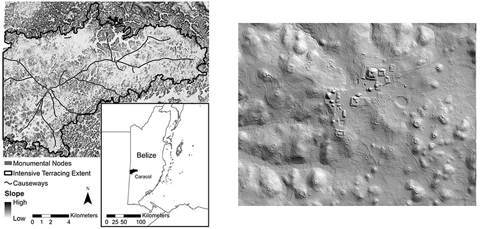
Figure 13. (i) Caracol urban area, Guatemala, ninth century CE. Lidar image and map. Source: Chase et al. (2020). Permission to publish granted by the copyright holder, Chase and Chase et al. (ii) Caracol central urban area, Guatemala, ninth century CE. Lidar image. Source: Chase et al. (2013). Permission to publish granted by the copyright holder, Chase and Chase et al.
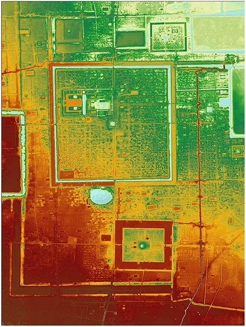
Figure 14. Central Angkor—from 2012 KALC lidar survey. KALC survey consortium member—the Greater Angkor Project.
Logical Constraints, in the Twentieth Century, on Comparison Across Different Magnitudes of Settlement Size
The non-recognition, until the start of the twenty first century, of low-density dispersed settlements in archaeology, as a systemic, global phenomenon across many scales of settlement size, is curious since they were well-known in anthropology and landscape studies by the mid-twentieth century, and the Classic Maya cases were clearly visible by the 1960s, as was the identification of the class of industrial urban “sprawl” i.e., dispersed, patchy urbanism in the modern world, as megalopolis, by Gottman in 1961. The term had even been used by Geddes in 1915 and by Lewis Mumford in his 1938 book “The Culture of Cities,” in relation to the vast, industrial urban conurbations, such as the Ruhr, which Mumford described as the first stage in urban overdevelopment and social decline. The question could therefore have been systematically asked, much earlier than it was, about whether there had been previous, dispersed urban settlements. Logically it should have been, since dispersed, low-density villages were well-known in Europe and appeared to have been a long-established settlement pattern. So, in principle, if agrarian villages and industrial cities could both take this form, variants for other socio-economic systems with the same spatial configuration could have been envisaged. A key deterrent was presumably, Childe's enormous prestige, and his “definition” of urbanism which included dense occupation, even though Childe also remarked on the difficulty to defining urbanism (1950), and the negative connotation applied to the initial expanding industrial conurbations.
As is apparent, empirical problems of observation do not suffice to explain the lack of an integrated recognition of the dispersed settlement form. The general phenomenon of dispersed occupation was known and the conclusion could have been reached that such a settlement form exists and has existed, long before the beginning of the twenty first century when remote sensing made it readily and spectacularly apparent. However, in addition to the combination of specific assumptions about the nature of urbanism and the practical issues of observation outlined above, a suite of broader conceptual premises was also in use up to the later 1970s which militated against the necessary cross-comparisons. In order to articulate a general proposition about human residential behavior being distributed across a wide range of occupation densities and to facilitate cross-comparison between settlement types of different spatial magnitudes, some basic assumptions about the relationship between classes of settlements were required as well as changes in fundamental assumptions about the relationship between materiality and sociality.
Only when stage theory was no longer tacitly accepted as self-evident and when materiality and sociality began to be decoupled after the 1970s could the segregation of the characteristics of the industrial cities from those of agrarian cities no longer be logically specified. This is a structural problem. Even in 2006, Bruegmann's book “Sprawl: a compact history” triggered no sustained engagement either for modern urbanists with the past or for archaeologists with sprawling industrial urbanism. The fundamental issue was that a generalized, linear evolution was the dominant model of culture until the 1970s despite the recognition of multi-linearity by Steward and others decades earlier. Stage Theory has been, and is still, a convenient way of managing the diversity and the vastly differing magnitudes of cultural behavior. But it logically emphasizes the significance of and the interest in difference between stages and presumes strong correlations between sociality and materiality within each stage, largely precluding cross—comparison between settlements of differing magnitudes and social function.
The assumption of direct material—social correlations was also problematic because it marginalized the material as an epiphenomenon of sociality. Different material expression were presumed for different social conditions so the generalized similarity of dispersed occupation with many different kinds of sociality was not a focus of interest. In addition, large patterns of materiality, such as settlement form, were not a concern of social anthropology for which the settlement was predominantly a backdrop for the active expression of social meaning. With a strong focus on sociality, the concepts and information that were transferred to archaeology did not emphasize general settlement form but primarily directed attention to specific house forms as the corollary of particular social systems. As a consequence, the knowledge of dispersed villages in social anthropology did not generally percolate across into the teaching programs of English-speaking archaeology in the middle of the twentieth century4.
The pragmatic needs of archaeological research and analysis seem to have diverted attention from the information readily available in the study of land use in Europe, and the precise observations by archaeologists in Europe that in some settlements the buildings were placed far apart e.g., Danubian sites (Soudský, 1962) and that in others they were very close together as in Skara Brae (Childe, 1931) and the Iron Age lake villages of Europe (e.g., Clarke, 1972) or in Catal Huyuk (Mellaart, 1967; Hodder, 2006). The focus in archaeology was primarily on compact settlements, despite the experience and expertise of the Mayanists, suggesting both that the compact settlement had become a normative type and that the compact settlement was a meaningful, practical, and theoretically substantial topic of inquiry. For the pragmatics of archaeology a compact site is an obvious and well-defined entity to study. In addition, the work of the landscape economy theorists such as von Thunen (see Chisholm, 1972) offered access to understanding the distribution of crop production, estimating food yields and thence calculating populations. And because archaeologists wanted to find ways to estimate the population size of past communities a consistent settlement area—population correlation was being sought from the 1930s to the 1980s (see commentary in Hassan, 1981). Essentially, normative, presumably modal densities were envisaged—such as an average of 100 p/ha for agricultural urbanism. Several critical papers on the issues of population estimates e.g., by Postgate for Mesopotamia (1994) made that problematic. To do population estimates for dispersed settlements requires some combination of r detailed economic data such as a rice field distributions and visible indicators of domestic water supply and the temporal structure of the settlement (Fletcher et al., 2003, p. 116–117, Hawken, 2011; Klassen, 2018). In the Maya settlements house mounds are generally visible. A sophisticated archaeology of domestic populations developed. The recognition of the problem in Maya sites that some households were not very visible on the surface (Johnson, 2004) illustrates the intellectual vigor and critical articulation of inquiry in a region with dispersed occupation.
The wide range of occupation densities in human communities world-wide did not resonate in the discipline—though its reporting (e.g., Fletcher, 1981, 1995) triggered no particular opposition. The information had little or no academic traction. The paradox is that archaeology has long recognized differential density of built space, has reported it for archaeological sites and has known of or had access to examples of such behavior for many decades. The key implication is that the dominant explanatory logic and the practical purpose of getting on with doing archaeology, demonstrates again that facts do not in themselves provide insights that lead to theories. Instead, pragmatically, such facts are simply anomalies to be left aside until some way to manage and integrate them can be envisaged (see Medawar, 1967).
Interaction-Communication Matrix
What we have tended to focus on are the ways in which interactions are managed socially and what kinds of verbalizable meaning are communicated by the messages transmitted within a community. However, when the material is regarded as an operator in its own right with consequential effects, because of its own characteristic, rather than as a consequence of or a carrier for the sociality with which it was associated, logical cross-associations can be made between settlements of very different magnitude and form (Fletcher, 1995). A basic example is that materiality manages interaction by providing barriers of various sorts and by assisting the transmission and retention of signals (Fletcher, 1995, p. 126–151). When therefore, instead of sociality and verbalized meaning, the degrees of intensity of interaction and degrees of adequacy of communication are considered as factors in their own right in community behavior, global cross comparability is feasible, at a very basic level5. The key is to view interaction as a condition which varies with occupation density, becoming increasingly more stressful the higher the density, and to view communication as an activity which becomes less effective with increasing distance, for any given means of communication. Settlement extent and occupation density are therefore consequential. An Interaction-Communication matrix (Figure 15) of density (Density—P/A) plotted in relation to community size (P) therefore allows, in principle, all settlements to be plotted relative to each other. When large numbers of settlements are plotted both globally and from national census data back to the nineteenth century (e.g., the Indian and Japanese national census data) it becomes apparent that human communities operate across an extremely wide range of residential densities. Even in densely inhabited countries like India and Japan the majority of towns have densities below 30–50 p/ha (Figure 16). And hunter- gatherer settlements range from residential densities of over 1,000 p/ha (e.g., the !Kung and the Efe) to <5 p/ha in some spread out—Ainu winter settlement camps—(Fletcher, 1995, p. 80; Whitelaw, 1991).

Figure 15. Interaction-Communication matrix—distribution of sample settlements. Prepared by Kirrily White.
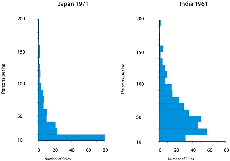
Figure 16. Prevalent lower densities in urban settlements mid twentieth century. Source public census data. Prepared by Kirrilly White.
Interaction limits: different upper operational densities are apparent for recent mobile and known sedentary communities (Figure 17). At lower densities the areal extent of settlements can be vastly larger than the equivalent for the largest dense settlements of the same kind of socio-economic system (see Figure 19). This is the phenomenon which the IC matrix brought into focus, which directed my attention to Angkor and led to the proposition that it was a low-density city. This characteristic of low-density settlements is a crucial feature of cultural processes because it allows them to exceed the maximum operable extent of a compact settlement area for a given communication system (Fletcher, 1995. p. 117, 121, 124).
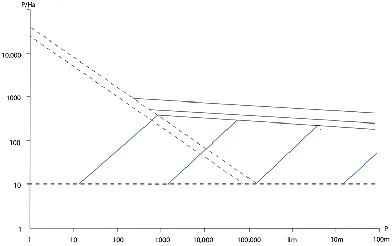
Figure 17. Interaction-Communication matrix limits. Prepared by Kirrily White.
Communication limits (Figure 17): the biggest compact literate, agrarian-based cities are in the 70–100 sq km range with populations around 1 to 1.5 million (Fletcher, 1995: p. 84–87, 130). Though this areal extent was attained by Chang'an in the eighth century CE (Xiong, 2000) it was not exceeded globally until the first half of the nineteenth century by London (Ackroyd, 2000). A Communication limit is therefore very constraining. While Angkor and Caracol, among others, could drop to low density and exceed the maximum area allowed by a given communication system for compact settlements they could not shift back up to a higher density form and could not apparently maintain either themselves or their extended settlements networks. The research at Angkor was initiated to investigate these issues and has provided reappraisals of its history (Fletcher, 2012; Lucero et al., 2015; Penny et al., 2018).
Over the past 15,000 years there have been three Communication limits identifiable by long period of stasis in the largest compact settlement sizes and by characteristic frequency distributions of the areal extent of settlements (Fletcher, 1986). The maximum settlement size ranges for compact settlements which have prevailed over several millennia, are about 0.7–1.0 ha for mobile communities, then about 70–100 ha for agrarian settlements and then 70–100 sq km for the great compact agrarian imperial capitals. Behind these successive C-Limits the usual distribution of the areal extent of site/settlement area is, respectively, below 3,000 sqm (relative to the 1 ha limit), 30 ha relative to the 100 ha limit and 30 sq km behind the 100 sq km limit. Most site/settlements areas are in the lower third of the size range behind a C-limit (Figure 18). The industrial urban size distribution is now mainly below 3,000 sq km.
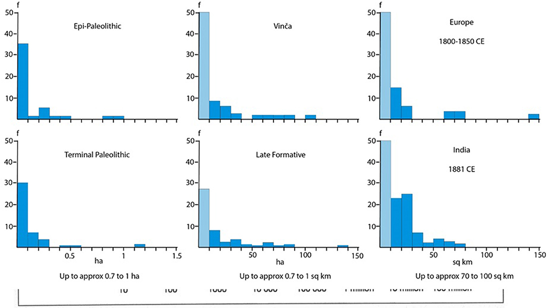
Figure 18. Site size distributions behind C-limits. Prepared by Kirrily White.
Trajectories: because the I-C matrix is a field model it can be used to display and analyze trajectories over time and the relationship between factors such as social conditions, economic circumstances and environmental processes, and the sizes of the settlements being affected by these factors (Figure 19). Most striking is that mobile communities, trend toward lower occupation densities as settlement area increases (Fletcher, 1990, 1991, 1995; Whitelaw, 1991, p. 76–80; 166; Fletcher, 1998) while known sedentary communities display the opposite trend (Figure 20; Fletcher, 1995, p. 170–177). This is crucial because it means that no one trend of density and settlement size is applicable to all human communities. The overall energetics of the trend in mobile and low-density settlements toward decreasing density with increasing community size are profoundly different from those in compact settlements where the density increases as the community size increases. In the latter communities greater stresses are placed on interaction and communication load while concurrently more interconnectedness is facilitated throughout the community. The key issue is whether central area in low-density settlements conform to the overall settlement density decrease with increasing community size (population) and settlement area or alternatively display their own trend to increased density as central area increase in population and areal extent—independent of the overall trend to density decrease of the whole expanding settlement (see below Issues p. 10–11).
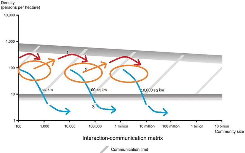
Figure 19. Types of trajectories on the Interaction-Communication matrix. Prepared by Kirrily White.
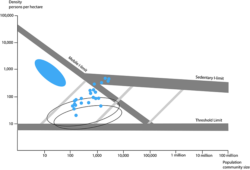
Figure 20. Density trend examples for mobile and sedentary communities on the Interaction-Communication matrix. Prepared by Kirrily White. Blue oval - Kalahari Bushman camps (1970s-1980s), blue dots Pueblos SW USA (1940s), open ovals UK villages 1960s (see Fletcher, 1995, Limits of Settlement Growth, p. 173).
This is consequential, because as well as density trends there are also several distinct trajectories of settlement growth and changes in overall settlement density over time. There are two, high density trajectories—one to stasis behind a C-limit and the other—which has been rare—a transition trajectory at high density across a C-limit—as for example by London in the early phase of the Industrial Revolution. A middle density band of trajectories is very varied, tends not to involve large changes in settlement size and given their constrained sizes is generally the predominant pattern for most settlements in the lower third of the size range behind a C-limit. The third trajectory (Fletcher, 1995, p. 117, 121, 124) is very distinct and drops to low-density as settlement area increases enormously. Vast expansion occurs but this is a terminal path which ends in the demise of the settlement. This trajectory, as noted above, cannot revert to higher density at the same large areal extent because the available communication system could not support coherent communication at higher density across that areal extent.
Outcomes
What is striking is that the same forms of socio-political organization, such as the state, operating in settlements on markedly different occupation density trajectories, lead to very different outcomes (Fletcher, 2010). While states do break down on both the higher density and low-density trajectories their longer-term histories are very different. Compact urban networks have repeatedly demonstrated enormous resilience of despite severe political changes such as the end of the Roman Empire. Specific settlements may fail but the overall network continues and urban recovery occurs within the existing system. The indications are that communities in compact settlements are extremely robust and able to make new socio-political adjustments in situ. There is long continuity in the traditions of compact settlements. Industrial London derives from Roman- Saxon London, Baghdad and Damascus have endured over centuries despite crisis and disaster. The development of early compact urbanism in lowland Mesopotamia and highland Mesoamerica has a direct ancestry in the small villages of those regions.
By contrast, the giant dispersed agrarian urban settlements of the Old and the New World had reverted to village farmland between the ninth and the fifteenth centuries and their urban networks were abandoned. The urban development of the future in lowland Mesoamerica, Sri Lanka and the eastern mainland of SE Asia formed up on the periphery of the former urban heartlands (Lucero et al., 2015). States survived in Southern Asia (Fletcher et al., 2017) but the old urban networks did not. Even more serious, there is no continuity in the development of dispersed settlement patterns. The industrial megalopolis and the desakota do not derive from or have any ancestry in the old giant, agrarian low-density cities. Nor do Angkor and Anuradhapura have any ancestry in the “Giants,” the smaller form of dispersed settlement in the 1–100 sq km range. And most of the “Giants” elsewhere in the world had no similar descendant (Fletcher and White, 2018). As ever, lowland Mesoamerica becomes critically important for our understanding of continuity in dispersed settlement systems because the Pre-Classic to Classic to early Post Classic does involve a succession of new low-density settlements, moving their main locus further and further north along the Yucatan peninsula. Only after the twelveth century does the shift to compact settlements occur around the periphery of the old urban heartlands.
Issues
Once the dispersed settlement patterns are recognized, the analysis of settlement behavior can shift from classes of settlement to trajectories with quantifiable magnitudes which can be related to patterns of outcome. A significant issue for the analysis of low-density urbanism is the patent accumulation of wealth, resources and innovation in the central, more densely occupied areas of these cities as population size increases. The implication may therefore be, that the model of Bettencourt et al. (2007) should apply to the denser areas of any urban settlement, worldwide across the spectrum from compact and dispersed form at all times. In agrarian—based, low-density settlements the denser central areas are simply smaller areas than can be attained by the maximum extent of higher density, compact settlements that use the same suite of communication systems. This proposition leads to an additional socio-political implication, of some consequence for the histories of dispersed urban settlements because the center—periphery “differential” in dispersed agrarian cities with very low, peripheral densities should be greater than in a compact city. This is not just that the rich get richer—it is that the whole social fabric of the denser more central areas gets “richer.” In a denser city that differential will be less and its “pay-offs” will be more accessible because the periphery is physically closer. By contrast, in a dispersed urban complex like Greater Angkor, the social differentiation between the denser center and the periphery should rise proportionately much faster for the central populace than for the peripheral populace who are also much further away from that cumulation. What should follow is that decoupling of wealth and social integration may be more severe in dispersed cities. If this can be tested in the old agrarian low-density cities it has some implications for the consequences of increasing social wealth differentials in our urban present and in the future of our gigantic, dispersed urban agglomerations.
As well as redefining central area sociopolitical processes the form of dispersed settlements also involves a reappraisal of the settlement's resource hinterland. In a dispersed agricultural village the extent of the occupation area is largely coincident with the community's staple resource hinterland because the fields are around and between the houses. Likewise, in Greater Angkor there were rice-fields all the way in to the front door of Angkor Wat, creating the “Metropolis of Rice-fields” (Hawken, 2011). Caracol's urban area, tied together by roads, secondary centers and outlier shrines is almost entirely terraced (Chase et al., 2011). Many years ago, Elizabeth Graham designated the “green” city to refer to the Maya sites (and see Graham, 2006), a proposition further developed by (Isendahl and Smith, 2013). It is therefore not tenable to argue that all settlements will have a simple spatial dichotomy between occupation area and crop resource hinterland, with the latter delimiting the extent of the former. When we add the information that the house gardens of Amazonian forest settlements provide a substantial portion of the domestic food supply (van der Waal, 2018) then the notion of what we mean by a hinterland for Angkor—and for other low-density, dispersed urban settlements needs to be robustly redefined, since houses in such settlements were presumably surrounded by economic trees and plants which would have made a substantial contribution to the domestic food supply.
A broader issue of taxonomy also needs to be addressed for low-density settlements. The terms we use for referring to settlements require rethinking. Formerly size, in terms of settlements area, could be a rough proxy for population and in stage theory settlement extent followed a linear trend from small camp to larger village to bigger town to huge city to colossal industrial megalopolis. No more. Greater Angkor covered the same area in the twelveth century as industrial Sydney did in Australia in 1945. And Angkor had bigger built reservoirs. But it was not an industrial city. Likewise, the low-density Giants may cover similar settlement areas as the conventionally defined, early urban settlements of China, Mesopotamia, Mesoamerica and the west coast or S America. And they can have large monuments. But that does not itself make them the same kind of places as the conventional defined compact, early cities, to all be designated under one label. We do, however, have to solve the conundrum of how to refer to the “Giants.” They cannot just be villages because that term is already used for numerous places in Europe and for the places like the Tallensi and Lobi Dagati settlements which consist of many domestic residential units—some larger than others—which do not have the equivalent of Cahokia's Monks Mound or the Acropolis of Great Zimbabwe. This is a quandary, as the “Giants” are also not the same as Greater Angkor but are attractively labeled as dispersed, agrarian urban settlements. Low-density settlement patterns are a well-established, inherent feature of human behavior. What we need are suitable ways to refer to them which will facilitate our understanding of them and their long-term role in human community life.
Conclusions
Dispersed settlement forms and multiple trajectories of growth are a necessary part of models of urbanism. By including them we need to decide whether we will further extend and dilute the meaning of “urban” or will seek new, additional ways to specify what we are talking about. Terminologies are crucial to inquiry not only because they aid communication about a topic but also, conversely because they affect what we “see.” Labels are not neutral—they relate to theoretical premises and they in turn define how empirical data become meaningful. “Urbanism” as a label with diffuse meaning is liable to generate diffuse cross-comparisons which retain older theoretical premises. While urbanism and urban will necessarily continue to be used and will likely transmute to a new meaning, just as “gravity” did from Newtonian to Einsteinian physics, other foundations for cross-comparison can be usefully developed.
Agrarian low-density urbanism, the “Giants” and contemporary megalopi and desakota can be cross-compared in terms of form and trajectory. Because this frame of reference is spatial and quantified, it specifies no equivalence of sociality, though it does specify similarities in the demands and management of interaction and communication. In this comparison the consistencies are trajectories of similar “direction” but very different magnitudes. By contrast, if we use “urban” to subsume all these kinds of settlements and all the range of compact urban settlements as well, we do specify a resemblance of sociality because that is what “urban” has come to mean while also being very diffuse. In addition, that resemblance is a quality not a mundane quantity. Therefore, if we use the term “urban” we will need to rigorously specify qualifiers such as “industrial” and the already defined “agrarian, low-density urbanism” i.e., cases like Angkor, Tikal, Pagan and Anuradhapura and we will likewise have to specify an “urban qualifier” for the “Giants” and a substantial definition of the difference that it incorporates.
The materiality of settlement form in terms of spatial magnitude and internal density becomes recognizable as a factor in its own right; rather than as an epiphenomenon of sociality. Denser occupation areas, in any form of settlement, become cross-referable. Defining the internal density structure of settlements and the characteristics of the edges of settlements and designating the location and characteristics of hinterlands become critical issues for all settlements instead of mundane and self-evident features, as in the normalized perception of compact settlements.
If, as appears to be the case, the trajectories of dispersed, low-density settlements lead to very different outcomes then materiality has serious consequences and needs to be habitually incorporated into models of the formation, expansion and demise of human communities. The implications are potentially very serious, and the numerous cross-comparison offered by the past are therefore of great potential value as guides to what can happen and perhaps an indicator of the consequences of various social and material alternative for coping with the situation.
The three trajectories to low-density settlement form which can be referred to as the “Giants” trajectory (from 4000 BCE), the agrarian urban, low-density trajectory (from the forth century BCE) and the industrial-based conurbations, megalopoli and desakota (from the late nineteenth century CE onwards), offer a new window into the history of settlement growth and the meanings of the term “urban.” They also offer a global basis for comparison and raise serious issues about the resilience of the low-density settlement form. Worryingly, the successive low-density settlements do not derive from the low-density cases of the preceding trajectory. Neither Angkor nor the Classic Maya cities had any connection to modern, industrial low-density cities. By contrast compact cities, the epitome of the conventional definition of cities, display continuity through successive urban settlement forms over several 1,000 years. The implications for modern, giant, low-density cities are ominous. They appear to face the risk of having no future.
Author Contributions
The author confirms being the sole contributor of this work and has approved it for publication.
Funding
This paper is funded via an OPEN-AIRE grant to Dr. Francesca Fulminante through the University of Rome (Marie Curie Sklodowska Fellowship 628818—Past-People-Nets 2014-2016).
Conflict of Interest Statement
The author declares that the research was conducted in the absence of any commercial or financial relationships that could be construed as a potential conflict of interest.
Acknowledgments
I am deeply grateful to Francesca Fulminante for inviting me to produce this paper. The task revealed far more than I had expected about the sources of my own awareness of low-density settlement patterns. To Meyer Fortes and especially to Jack Goody I will be forever grateful for the opportunities which took me to extraordinary places in Northern Ghana. To Christophe Pottier, the many members of the Greater Angkor Project and to the staff of APSARA and members of the government of Cambodia I am very grateful for the engagement, work and support which enabled the redefining of Angkor as a low-density city. To Luis Bettencourt, Scott Ortman, Mike Smith, Jose Lobos, and Sarah Klassen I am grateful for discussions about central areas of urban settlements, scaling, and the outer limits of settlement space. For illustrations in this paper my thanks to Jerry Sabloff for advice, to Bob Hudson. Scott Hawken, Todd Whitelaw and Andrew Wilson for images which they produced and to Kirrily White for preparing even more at very short notice. Much appreciated.
Footnotes
1. ^As I well know from living in such settlements in the early 1970s, when I was doing village household surveys in Ghana for my PhD research.
2. ^SAA conference sessions 2013 and 2017. Amerind Foundation Symposium in 2014.
3. ^I remain deeply grateful to the staff of the National Air and Space Museum in the Smithsonian Institution for saying to me after a seminar, “by the way, have you seen the radar image of Angkor from the Space Shuttle?”
4. ^My own knowledge of these kinds of settlements was due to the happenstance that I met Meyer Fortes, and was taught by Jack Goody, in Cambridge who both assisted me to work in the Tallensi and LoDagaba regions of Ghana on the village surveys which were part of my PhD research.
5. ^Traffic analysis is required, as defined in cryptography—the interception and examination of the physical characteristics of messages such as frequency, rate and internal structure to deduce information from the patterns of transmission, even if the content of the messages cannot be decoded (Callimahos, 1989).
References
Angel, S., Blei, A. M., Parent, J., Lamson-Hall, P., and Galarza, N. (2016). Atlas of Urban Expansion−2016 Edition, Vol. 1: Areas and Densities. New York, NY; Nairobi; Cambridge, MA: New York University, UN-Habitat, Lincoln Institute of Land Policy.
Angel, S., Parent, J., and Civco, D. L. (2012). The fragmentation of urban landscapes: global evidence of a key attribute of the spatial structure of cities, 1990-2000. Environ. Urban. 24, 249–283. doi: 10.1177/0956247811433536
Angel, S., Sheppard, S., and Civco, D. (2005). The Dynamics of Global Urban Expansion. Washington, DC: The World Bank.
Baires, S. E. (2015). The role of water in the emergence of the pre-Columbian Native American City Cahokia. WIREs Water 2, 489–503. doi: 10.1002/wat2.1094
Bettencourt, L. M. A., Lobo, J., Helbing, D., Kühnert, C., and West, G. B. (2007). Growth, innovation, scaling, and the pace of life in cities. PNAS 104, 7301–7306. doi: 10.1073/pnas.0610172104
Black, S. (1990). The Carnegie Uaxactun Project and the development of maya archaeology. Ancient Mesoam. 1, 257–276. doi: 10.1017/S0956536100000298
Callimahos, L. D. (1989). Traffic Analysis and the Zendian Problem. Walnut Creek, CA: Aegean Park Press.
Cerne, A. (2004). Dispersed and decentralised settlement system. Dela 21, 83–95. doi: 10.4312/dela.21.83-95
Chapman, J., Videiko, M. Y., Hale, D., Gaydarska, B., Burdo, N., Rassmann, K., et al. (2014). The second phase of the Trypillia mega-site methodological revolution: a new research agenda. Eur. J. Archaeol. 17, 369–406. doi: 10.1179/1461957114Y.0000000062
Chase, A. F., Chase, D. Z., Fisher, C. T., Leisz, S. J., and Weishampel, J. F. (2012). Geospatial revolution and remote sensing LiDAR in Mesoamerican archaeology. Proc. Natl. Acad. Sci. U.S.A. 109, 12916–12921. doi: 10.1073/pnas.1205198109
Chase, A. F., Chase, D. Z., and Weishampel, J. F. (2010). Lasers in the jungle: airborne sensors reveal a vast Maya landscape. Archaeology 64, 27–29.
Chase, A. F., Chase, D. Z., and Weishampel, J. F. (2013). “The Use of LiDAR at the Maya site of Caracol, Belize,” in Mapping Archaeological Landscapes from Space: In Observance of the 40th Anniversary of the World Heritage Convention, eds D. Comer and M. Harrower (New York, NY: Springer), 187–197.
Chase, A. F., Chase, D. Z., Weishampel, J. F., Drake, J. B., Shrestha, R. L., Slatton, K. C., et al. (2011). Airborne LiDAR, archaeology, and the ancient Maya landscape at Caracol, Belize. J. Archaeol. Sci. 38, 387–398. doi: 10.1016/j.jas.2010.09.018
Chase, D. Z., Chase, A. F., and Chase, A. S. Z. (2020). “Caracol's impact on the landscape of the classic period Maya: urbanism and complex interaction in a tropical environment,” in Approaches to Monumental Landscapes of the Ancient Maya, eds B. A. Houk, B. Arroyo, and T.G. Powis (Gainesville, FL: University Press of Florida).
Childe, V. G. (1950). The urban revolution. Town Plan. Rev. 21, 3–17. doi: 10.3828/tpr.21.1.k853061t614q42qh
Chirikure, S., Bandama, F., Chipunza, K., Mahachi, G., Matenga, E., Mupira, P., et al. (2016). Seen but not told: re-mapping great Zimbabwe using archival data, satellite imagery and geographical information systems. J. Archaeol. Method Theory 24, 489–513. doi: 10.1007/s10816-016-9275-1
Chirikure, S., Moultrie, T., Bandama, F., Dandara, C., and Manyanga, M. (2017). What was the population of Great Zimbabwe (CE1000 - 1800)? PLoS ONE 12:e0178335. doi: 10.1371/journal.pone.0178335
Clarke, D. L. (1972). “A Provisional Model of an Iron Age Society and its Settlement System,” in Models in Archaeology, ed D. L. Clarke (London: Methuen, 801–869.
Coningham, R. A. E., and Gunawardhana, P. (2013). Anuradhapura, The Hinterland. Vol. 3. Oxford: BAR International Series.
Daguan, Z. (2007). A Record of Cambodia: The Land and Its People. Translated by P. Harris. Chang Mai: Silkworm Books.
Devendra, D. T. (1959). Seventy years of Ceylon archaeology. Artibus Asiae 22, 23–40. doi: 10.2307/3249140
Doxiadēs, K. A. (1968). Ekistics: An Introduction to the Science of Human Settlements. London: Hutchinson.
Drake, B. L., Wills, W. H., Hamilton, M. I., and Dorshow, W. (2014). Strontium isotopes and the reconstruction of the Chaco regional system: evaluating uncertainty with Bayesian mixing models. PLoS ONE 9:e95580. doi: 10.1371/journal.pone.0095580
Evans, D. (2007). Putting Angkor on the map: a new survey of a Khmer ‘hydraulic city' in historical and theoretical context (Unpublished Ph.D. thesis). The University of Sydney, Camperdown, NSW, Australia.
Evans, D., and Fletcher, R. (2015). The landscape of Angkor Wat redefined. Antiquity 89, 1402–1417. doi: 10.15184/aqy.2015.157
Evans, D., Pottier, C., Fletcher, R., Hensley, S., Tapley, I., Milne, A., et al. (2007). A comprehensive archaeological map of the world's largest preindustrial settlement complex at Angkor, Cambodia. Proc. Natl. Acad. Sci. U.S.A. 104, 14277–14282. doi: 10.1073/pnas.0702525104
Evans, D. H., Fletcher, R. J., Pottier, C., Chevance, J. B., Soutif, D., Tan, B. S., et al. (2013). Uncovering archaeological landscapes at Angkor using lidar. Proc. Natl. Acad. Sci. U.S.A. 110, 12595–12600. doi: 10.1073/pnas.1306539110
Fletcher, R. (1995). The Limits of Settlement Growth: A Theoretical Outline. Cambridge: Cambridge University Press.
Fletcher, R. J. (1981). “People and Space,” in Pattern of the Past: Essays in Honour of David Clarke, eds I. Hodder, G. Isaac, and N. Hammond (Cambridge: Cambridge University Press, 97–128.
Fletcher, R. J. (1986). Settlement archaeology: world-wide comparisons. World Archaeol. 18, 59–83. doi: 10.1080/00438243.1986.9979989
Fletcher, R. J. (1990). “Residential densities, group size and social stress in Australian Aboriginal settlements”, in Hunter-gatherer demography: past and present, eds. B. Meehan, and N. White (Sydney: Oceania Monographs), 81–95.
Fletcher, R. J. (1991). “Very Large Mobile Communities: interaction stress and residential dispersal,” in Ethnoarchaeological Approaches to Mobile Campsites: Hunter-gatherer and Pastoralist Case-studies, eds C. S Gamble and W. A. Boismer (Ann Arbor, MI: International Monographs in Prehistory, 395–420.
Fletcher, R. J. (1998). “African urbanism: scale, mobility and transformations,” in Africa: Pre-colonial Achievements, ed G. Connah (London: Cassells, 104–38.
Fletcher, R. J. (2010). “Urban Materialities: Meaning, Magnitude, Friction, and Outcomes,” in The Oxford Handbook of Material Culture Studies, eds D. Hicks and M. C. Beaudry (New York, NY: Oxford University Press, 459–483.
Fletcher, R. J. (2012). “Low-density, agrarian-based urbanism: scale, power, and ecology,” in The Comparative Archaeology of Complex Societies, ed M. E. Smith (New York, NY: Cambridge University Press, 285–320.
Fletcher, R. J., Barbetti, M., Evans, D., Than, H., Sorithy, I., Chan, K., et al. (2003). Redefining Angkor: structure and environment in the largest, low density urban complex of the pre- industrial world. UDAYA 4, 107–121.
Fletcher, R. J., Buckley, B. M., Pottier, C., and Wang, S.-Y. (2017). “The case of Angkor and monsoon extremes in Mainland Southeast Asia,” in Megadrought and Collapse: From Early Agriculture to Angkor, ed H. Weiss (New York, NY: Oxford University Press), 352.
Fletcher, R. J., and White, K. (2018). “Tropical environments and trajectories to low-density settlement forms,” in Exploring Frameworks for Tropical Forest Conservation. Integrating Natural and Cultural Diversity for Sustainability. A Global Perspective, ed N. Sanz (Mexico City: UNESCO, 92–115.
Fowler, M. L. (1989). The Cahokia Atlas: A Historical Atlas of Cahokia Archaeology. Springfield, IL: Illinois Historic Preservation Agency.
Garlake, P. S. (1970). Rhodesian ruins - a preliminary assessment of their styles and chronology. J. Afr. Hist. 11, 495–513. doi: 10.1017/S0021853700010422
Gaucher, J. (2004). Angkor Thom, une utopie réalisée? Structuration de l'espace et modèle d'urbanisme dans le Cambodge ancient. Arts Asiatiques 59, 58–86. doi: 10.3406/arasi.2004.1515
Geddes, P. (1915). Cities in Evolution. An Introduction to the Town Planning Movement and to the Study of Civics. London: Williams.
Gottman, J. (1961). Megalopolis: The Urbanization of the North-Eastern Seaboard of the United States. New York, NY: Twentieth Century Fund.
Graham, E. (1999). “Stone cities, Green cities,” in Complex Polities in the Ancient Tropical World, eds E. A. Bacus and L. J. Lucero (Arlington: Archaeological Papers of the American Anthropological Association), 185–194.
Graham, E. (2006). “Maya cities and the character of a tropical urbanism,” in Reconstructing the Past: Studies in Mesoamerican and Central American Prehistory, eds D. M. Pendergast and A. P. Andrews (Oxford: John and Erica Hedges, 151–158.
Groslier, B.-P. (1979). La cité hydraulique Angkorienne: Exploitation ou surexploitation du sol? Bull. Écol. Française d' Extrême Orient. 66, 161–202. doi: 10.3406/befeo.1979.4014
Gunawardana, R. A. L. H. (1971). Irrigation and hydraulic society in early medieval Ceylon. Past Present 53, 3–27. doi: 10.1093/past/53.1.3
Hassan, F. (1981). Demographic Archaeology. Adv. Archaeol. Method Theory 4, 225–279. doi: 10.1016/B978-0-12-624180-8.50010-X
Hawken, S. (2011). Metropolis of ricefields: a topographic classification of a dispersed urban complex (Unpublished Ph.D. thesis). The University of Sydney, Camperdown, NSW, Australia.
Hodder, I. (2006). The Leopard's Tale: Revealing the Mysteries of Çatalhöyük. London: Thames and Hudson.
Hudson, B. (2004). The origins of Bagan: The archaeological landscape of upper Burma to AD 1300 (Unpublished Ph.D. thesis). The University of Sydney, Camperdown, NSW, Australia.
Isendahl, C. (2012). Agro-urban landscapes: the example of Maya lowland cities. Antiquity 86, 1112–1125. doi: 10.1017/S0003598X00048286
Isendahl, C., and Smith, M. E. (2013). Sustainable agrarian urbanism: the low-density cities of the Mayas and Aztecs. Cities 31, 132–143. doi: 10.1016/j.cities.2012.07.012
Jacques, C. (1978). VI. Études d'épigraphie cambodgienne. XL autour de quelques toponymes de l'inscription du Prasat Trapan Run K.598: la capitale angkorienne de Yašovarman Ier à Sûryavarman Ier. Bull. Écol. Française d'Extrême Orient. 65, 281–332. doi: 10.3406/befeo.1978.3909
Johnson, K. J. (2004). The “Invisible” Maya: minimally mounded residential settlement at Itzan, Peten, Guatemala. Latin Am. Antiquity 15, 141–175. doi: 10.2307/4141552
Kelly, J. E., and Brown, J. A. (2014). “Cahokia: the processes and principles of the creation of an early Mississippian city,” in Making Ancient Cities. Space and Place in Early Urban Societies, ed A. T. Creekmore and K. D. Fisher (Cambridge: Cambridge University Press, 292–336.
Klassen, S. (2018). Adaptive capacity of the water management systems of two medieval Khmer cities, Angkor and Koh Ker (Ph.D. dissertation). Arizona State University, Phoenix, AZ, United States.
Lucero, L., Fletcher, R., and Coningham, R. (2015). From ‘collapse' to urban diaspora: the transformation of low-density, dispersed agrarian urbanism. Antiquity 89, 1139–1154. doi: 10.15184/aqy.2015.51
McCNetting, R. (1968). Hill Farmers of Nigeria: Cultural Ecology of the Kofyar of the Jos Plateau. Seattle, WA: University of Washington Press.
McGee, T. G. (1967). The Southeast Asian City: A Social Geography of the Primate Cities of Southeast Asia. London: Bell.
McGee, T. G. (1991). “The emergence of Desakota regions in Asia: expanding a hypothesis,” in The Extended Metropolis: Settlement Transition In Asia, eds N. S. Ginsburg, B. Koppel, and T. G. McGee (Honolulu: University of Hawaii Press, 3–25.
Moore, E. (2000). Angkor water management, radar imaging, and the emergence of urban centres in Northern Cambodia. J. Sophia Asian Stud. 18, 39–51.
Moore, T., Braun, A., Creighton, J., Cripps, L., Haupt, P., Klenner, I., et al. (2013). Oppida, agglomerations and suburbia: the Bibracte environs and new perspectives on Late Iron Age urbanism in Central-Eastern France. Eur. J. Archaeol. 44, 491–517. doi: 10.1179/1461957113Y.0000000034
Morrill, R. (2006). Classic map revisited: the growth of megalopolis. Profess. Geogr. 58, 155–160. doi: 10.1111/j.1467-9272.2006.00522.x
Murzin, V. Y., Rolle, R., and Suprunenko, O. (1999). Bil's'ke Gorodishche (The Belsk City-Site), Kiev. Hamburg: Poltava.
Nebbia, M. (2017). Early cities or large villages? Settlement dynamics in the Trypillia group, Ukraine (Ph.D. thesis). Durham University, Durham, United Kingdom.
O'Connell, J. (1977). Room to move: contemporary Alyawara settlement patterns and their implications for Aboriginal housing policy. Mankind 11, 119–131. doi: 10.1111/j.1835-9310.1977.tb01173.x
Pauketat, T. R., Alt, S. M., and Kruchten, J. D. (2015). “City of earth and wood: New Cahokia and its material-historical implications,” in The Cambridge World History, ed N. Yoffee (Cambridge: Cambridge University Press, Cambridge Histories Online, 437–454.
Penny, D., Zachreson, C., Fletcher, R., Lau, D., Lizier, J., Fischer, N., et al. (2018). The demise of Angkor: Systemic vulnerability of urban infrastructure to climatic variations. Sci. Adv. 4:eaau4029, 1–8. doi: 10.1126/sciadv.aau4029
Pikirayi, I., and Chirikure, S. (2011). Debating great Zimbabwe. Azania Archaeol. Res. Afr. 46, 221–231. doi: 10.1080/0067270X.2011.580149
Postgate, J. N. (1994). How many Sumerians per hectare? Probing the anatomy of an early city. Cambridge Archaeol. J. 4, 47–65. doi: 10.1017/S0959774300000962
Pottier, C. (1999). Carte archéologique de la région d'Angkor. Zone Sud Vol. 3 (Ph.D. thesis) Université Paris III - Sorbonne Nouvelle; UFR Orient et Monde Arabe, Paris, France.
Pottier, C. (2000). À la recherche de Goloupura. Bull. Écol. Française Extrême Orient. 87, 79–107. doi: 10.3406/befeo.2000.3471
Pottier, C. (2005). “La Mission archéologique Franco-Khmère sur l'aménagement du territoire Angkorien,” in Archéologies 20 ans de Recherches Françaises Dans le Monde (Paris: Maisonneuve and Larose - ADPF-ERC), 636–638.
Pottier, C., and Evans, D. (2010). “Carte archéologique du Grand Angkor,” in Archéologues à Angkor. (Paris: Paris Musées, 228–229.
Poux, M. (2014). “Enlarging oppida: multipolar town patterns in Late Iron Age Gaul,” in Paths to Complexity. Centralisation and Urbanisation in Iron Age Europe, eds M. Fernández-Götz, H. Wendling, and K. Winger (Oxford: Oxbow, 156–196.
Price, T. D., Plog, S., LeBlanc, S. A., and Krigbaum, J. (2017). Great House origins and population stability at Pueblo Bonito, Chaco Canyon, New Mexico: the isotopic evidence. J. Archaeol. Sci. Rep. 11, 261–273. doi: 10.1016/j.jasrep.2016.11.043
Puleston, D. E. (1973). Ancient Maya settlement patterns and environment at tikal, Guatemala: implications for subsistence models (Ph.D. Dissertation). University of Pennsylvania.
Sabloff, J. A. (1990). The New Archaeology and the Ancient Maya. New York, NY: Scientific American Library.
Sabloff, J. A., and Fash, W. L. (2007). Gordon R. Willey and American Archaeology: Contemporary Perspectives. Oklahoma City: University of Oklahoma Press.
Sharer, R. J., and Traxler, L. P. (2006). The Ancient Maya. Palo Alto, CA: Stanford University Press.
Shramko, B. A. (1987). Bel'Skoye Gorodishche Skifskoy Epokhi (gorod Gelon) (Belsk Settlement of the Scythian Era - Gelon Town). Kiev: Naukova Dumka.
Shramko, B. A. (2012). Belsk Settlement - The Largest Settlement Complex in the Forest-Steppe Scythia. The Phenomenon of the Belsk Settlement: Preservation, Study and Popularization of the Europe's Largest Early Iron Age Monument. Kiev: Monument Research Center at Ukraine NAS and UTOPIK (in Russian).
Sievers, S., and Schönfelder, M. (eds.). (2012). La Question de la Proto-Urbanisation à l'Âge du Fer, Akten des 34. Internationale Kolloquiums der AFEAF vom 13-16 Mai 2010 in Aschaffenburg, 1–14. Bonn: Dr. Rudolf Habelt GmbH.
Soudský, B. (1962). The neolithic site of bylany. Antiquity 36, 190–200, doi: 10.1017/S0003598X00036577
Taylor, T. (1987). Aspects of settlement diversity and classification in south-east Europe before the Roman period. World Archaeol. 19, 1–22. doi: 10.1080/00438243.1987.9980020
van der Waal, H. (2018). “Agrobiodiversidad en huertos familiares y conservación de los bosques tropicales: el caso del sureste de México,” in Exploring Frameworks for Tropical Forest Conservation. Integrating Natural and Cultural Diversity for Sustainability, a Global Perspective, ed N. Sanz (Mexico City: UNESCO, 254–265.
Vivian, R. G. (1970). Aspects of prehistoric society in Chaco Canyon, New Mexico (Ph.D. thesis). The University of Arizona, Tucson, AZ, United States.
Watanabe, H. (1973). The Ainu Ecosystem: Environment and Group Structure. Seattle, WA: University of Washington Press.
Webster, D. (2007). The Uses and Abuses of the Ancient Maya. Prepared for The Emergence of the Modern World Conference. (Otzenhausen. Organizers Jared Diamond and James Robinson).
Whitelaw, T. M. (1991). “Some dimensions of variability in the social organization of community space among foragers,” in Ethnoarchaeological Approaches to Mobile Campsites: Hunter-Gatherer and Pastoralist Case-studies, eds C. S Gamble and W. A. Boismer (Ann Arbor, MI: International Monographs in Prehistory, 139–188.
Willey, G. R. (1956). The structure of ancient Maya society: evidence from the southern lowlands. Am. Anthropol. 58, 777–782. doi: 10.1525/aa.1956.58.5.02a00020
Wills, W. H., and Dorshow, W. B. (2012). Agriculture and community in Chaco Canyon: revisiting Pueblo Alto. J. Anthropol. Archaeol. 31, 138–155. doi: 10.1016/j.jaa.2011.11.002
Xiong, V. C. (2000). Sui-Tang Chang'an. A Study in the Urban History of Late Medieval China, Vol. 85. University of Michigan, Centre for Chinese Studies. University of Michigan Press.
Zbenovich, V. G. (1996), The Tripolye culture: centenary of research. J. World Prehist. 10, 199–241. doi: 10.1007/BF02221076
Zöllner, H., Ullrich, B., Rolle, R., Makhortykh, S., and Orlyuk, M. (2008). “Results of geophysical prospection in the Scythian settlement of Belsk (Bol'šoe Belskoe Gorodišče),” in Layers of Perception. Proceedings of the 35th International Conference on Computer Applications and Quantitative Methods in Archaeology (CAA), Berlin, Germany, eds A. Posluschny, K. Lambers, and I. Herzog (Bonn: Rudolf Habelt Verlag, 1–4.
Keywords: low-density, urban, past, present, future
Citation: Fletcher R (2019) Trajectories to Low-Density Settlements Past and Present: Paradox and Outcomes. Front. Digit. Humanit. 6:14. doi: 10.3389/fdigh.2019.00014
Received: 15 January 2019; Accepted: 19 July 2019;
Published: 28 August 2019.
Edited by:
Francesca Fulminante, University of Bristol, United KingdomReviewed by:
Alex Elias Morrison, The University of Auckland, New ZealandAparna Basu, South Asian University, India
Copyright © 2019 Fletcher. This is an open-access article distributed under the terms of the Creative Commons Attribution License (CC BY). The use, distribution or reproduction in other forums is permitted, provided the original author(s) and the copyright owner(s) are credited and that the original publication in this journal is cited, in accordance with accepted academic practice. No use, distribution or reproduction is permitted which does not comply with these terms.
*Correspondence: Roland Fletcher, cm9sYW5kLmZsZXRjaGVyQHN5ZG5leS5lZHUuYXU=