 Luísa Bastos
 Ana Bio
 Isabel Iglesias
- 1Centro Interdisciplinar de Investigação Marinha e Ambiental, Universidade do Porto, Porto, Portugal
- 2Faculdade de Ciências, Universidade do Porto, Porto, Portugal
Coastal and Oceanic Observatories are important tools to provide information on ocean state, phenomena, and processes. They meet the need for a better understanding of coastal and ocean dynamics, revealing regional characteristics, and vulnerabilities. These observatories are extremely useful to guide human actions in response to natural events and potential climate change impacts, anticipating the occurrence of extreme weather and oceanic events and helping to minimize consequent personal and material damages and costs. International organizations and local governments have shown an increasing interest in operational oceanography and coastal, marine and oceanic observations, which resulted in substantial investments in these areas. A variety of physical, chemical and biological data have been collected to better understand the specific characteristics of each ocean area and its importance in the global context. Also the general public's interest in marine issues and observatories has been raised, mainly in relation to vulnerability, sustainability and climate change issues. Data and products obtained by an observatory are hence useful to a broad range of stakeholders, from national and local authorities to the population in general. An introduction to Ocean Observatories, including their national and regional importance, and a brief analysis of the societal interest in these observatories and related issues are presented. The potential of a Coastal and Ocean Observatory is then demonstrated using the RAIA observatory as example. This modern and comprehensive observatory is dedicated to improve operational oceanography, technology, and marine science for the North Western Iberian coast, and to provide services to a large range of stakeholders.
Introduction
Monitoring the state of the ocean is necessary to characterize and understand coastal and ocean dynamics and vulnerabilities at different temporal and spatial scales and to measure the impact of global and local conditions, and of human activities. Ocean, estuarine, and coastal areas are vast and often difficult to access and, therefore, generally under-sampled and poorly understood. This is particularly serious considering their biological and physical complexity and the natural and societal importance of these systems, which provide numerous ecosystem services (in terms of carbon and nutrient storage, fishery resources, biodiversity, biomass, biofuels production, wind and wave energy, tourism and recreation, water catchment, agriculture, bioactive compounds, coastal protection, etc.).
Coastal and Oceanic Observatories play a key role in providing (near) real-time information for operational oceanography at regional and local scales, to answer key societal and scientific challenges. They are able to collect data in a regular and consistent way, at adequate temporal and spatial scales, and provide information to a broad range of stake-holders, supporting decision makers in maintaining the well-being and safety of populations, and the sustainability of marine and coastal ecosystems and services. Next to unraveling oceanic patterns and dynamics, these observatories have proven to be important tools to support the sustainable use of the ocean and coastal zones and to promote an effective integrated coastal zone management. They provide sound and comprehensive information on ocean state, phenomena and processes, allowing to predict the effects of anthropic actions and natural events, anticipate extreme weather events, and draw climate change scenarios.
The main objective of an Ocean Observatory is to tackle important questions related to marine systems and resources, their dynamics and sustainability, and to provide a source of information for stake-holders and society in general. They do so ensuring long-term monitoring to understand ocean and coastal variability and integrating all process steps from data to information. Observatories can collect, process, analyse and supply large amounts of oceanic data, such as physical, meteorological, biological and chemical parameters, data on sediments, ocean noise, bottom topography, seismology, or coastline morphology. These data, which constitute important information by themselves, are also converted to products (statistics, charts, maps) and used for modeling and predictions. They are indispensable to feed the numerical models that aim at representing physical, chemical, biological, and geological characteristics of these systems, to provide reliable estimates and forecasts.
International organizations and local governments have acknowledged the interest in and need for operational oceanography and coastal, marine and oceanic observations, and there is a large amount of money dedicated to these issues. There have been massive investments in satellite observation systems (more than 4 billion Euros for the European Space Agency's Copernicus program alone), which are able to provide regularly repeated, global data on key variables. Yet in spite of the good temporal and spatial coverage of satellite observations and the numerous variables that can be directly observed or inferred, in situ data are still of enormous importance. In situ data are much more precise and accurate, and allow calibration and validation of satellite data. Furthermore, variables below the surface where the satellites are not able to observe, as well as many variables that cannot be measured directly from space (Legler et al., 2015) need to be assessed in situ.
The importance of these datasets was early recognized by the European Union (EU). The Galway Declaration (Eurocean, 2004), which had a major influence on the EU FP7 Programme and the EU Maritime Policy Green Paper (Commission of the European Communities, 2006), and the Aberdeen Declaration (Eurocean, 2007), which initiated the European Marine and Maritime Science, Research, Technology and Innovation Strategy, recognized the great importance of the oceans and seas for Europe's economic, social, and environmental development. They promoted economic development, environmental management and ocean and coastal governance, also contributing to an European response to Global Climate Change, through a partnership focused on mitigation and adaptation, mobilizing existing and establishing new ocean observatory and data collection systems. This led to several programs, such as the European Marine Observation and Data Network (EMODNET), which joined the EU member states' monitoring programmes and marine data management centers into one unique structure. Other European proposals that integrated datasets and systems are the European Directory of the initial Ocean-observing Systems (EDIOS), SEA-SEARCH (www.sea-search.net), and SEADATANET (www.seadatanet.org) providing transparent access to marine datasets and data products (Proctor and Howart, 2008).
Other initiatives to monitor several ocean variables in situ on large spatial scales are: the European Multidisciplinary Seafloor and water column Observatory (EMSO, http://www.emso-eu.org/site/, Favali and Beranzoli, 2009), the European Coastal sea Operational Observing and forecasting system (ECOOP, www.ecoop.eu), the Marine Environment and Security for the European Area (MERSEA, https://www.nersc.no/project/mersea, Johannessen et al., 2006), the Ocean Observatories Initiative (OOI, http://oceanobservatories.org/, Isern and Clark, 2003), the Integrated Ocean Observing System (IOOS, http://www.ioos.noaa.gov/, Ocean US, 2002) the MarineGEO & Tennenbaum Marine Observatories Network (http://marinegeo.si.edu/initiative/program-overview), the Global Ocean Observing System (GOOS, http://www.ioc-goos.org/, Malone, 2003), the Global Sea Level Observing System (GLOSS, http://www.gloss-sealevel.org/, Merrifield et al., 2009), the Partnership for Observation of the Global Oceans (POGO, http://ocean-partners.org/), the Scientific Committee on Oceanic Research (SCOR, http://www.scor-int.org/, Boyd et al., 2011), and Argo (http://www.argo.net/, Roemmich et al., 2009).
However, these huge initiatives generally require large investments to be implemented, operated and maintained, and for further development of the observatories. The funding is usually linked to administration, government agencies and international organizations, and can suffer constraints due to conjuncture (U.S. Commission on Ocean Policy, 2004; Proctor and Howart, 2008). This is why national and regional Coastal Observatories have gained societal and scientific importance through the years. Local observatories can satisfy specific demands of the country as well as local needs, sometimes using a single and affordable monitoring system. They work at regional scales, allowing observation of regional patterns, and can focus and tailor their data and develop outputs and products according to regional interests and priorities (e.g., fisheries, aquaculture, tourism).
Many ocean observation platforms started out as experimental research units and developed into operational networks to supply data to science, public institutions, and stakeholders. Local coastal observing systems can be grouped into regional associations to satisfy national demands. An example is the Regional Coastal Ocean Observing Systems (RCOOSs, Seim et al., 2009) of the IOOS that includes the Alaska Ocean Observing System (AOOS, http://www.aoos.org/), the Central California Ocean Observing System (CeNCOOS, http://www.cencoos.org/), the Great Lakes Observing System (GLOS, http://www.glos.us/), the Gulf of Maine Ocean Observing System (GoMOOS), the Gulf of Mexico Coastal Ocean Observing System (GCOOS, http://gcoos.org/), the Pacific Islands Ocean Observing System (PacIOOS, http://oos.soest.hawaii.edu/pacioos/), the Mid-Atlantic Coastal Ocean Observing Regional Association (MACOORA, http://marine.rutgers.edu/marcoos/), the Northwest Association of Networked Ocean Observing Systems (NANOOS, http://www.nanoos.org/), the Southern California Ocean Observing System (SCCOOS, http://www.sccoos.org/), the Southeast Coastal Ocean Observing Regional Association (SECOORA, http://secoora.org/) and the Caribbean Integrated Ocean Observing System (CarICOOS, http://www.caricoos.org/). Another example are the six Regional Programmes for the National Network of Regional Coastal Monitoring Programmes of England (http://www.channelcoast.org/, Rodwell et al., 2014) that include the North West Strategic Regional Coastal Monitoring Programme, the North East Coastal Observatory (NECO, http://www.northeastcoastalobservatory.org.uk/), the East Riding of Yorkshire Council's Coastal Team (ERYC), Anglian Coastal Monitoring, Southeast Strategic Regional Coastal Monitoring Programme and Southwest Strategic Regional Coastal Monitoring Programme.
Next to associated observatories, there are several regional Coastal Observatories providing more or less data and services, for instance: NEPTUNE in the NE Pacific and VENUS in the Salish Sea (both from the Ocean Networks Canada: http://www.oceannetworks.ca/, Taylor, 2009); Martha's Vineyard Coastal Observatory (U.S., http://www.whoi.edu/mvco); the U.S. Cabled Array Fiber-Optic Ocean Observatory across the Juan de Fuca tectonic plate in the National Science Foundation's OOI, the Mayotte Island coastal observatory a French island in the Indian Ocean (Jeanson et al., 2014); the Liverpool Bay Coastal Observatory (England; http://coastobs.pol.ac.uk/, Howarth and Palmer, 2011); the Observatorio Medioambiental del Estrecho de Gibraltar (OME, South Spain); OBSEA (Barcelona, Spain http://www.upc.edu/cdsarti/OBSEA/index.php, Aguzzi et al., 2011); and the RAIA Observatory (NW Iberian Peninsula, Spain and Portugal; http://www.marnaraia.org/), which will be presented here in more detail. While some of them do not even have accessible websites (e.g., U.S. Cabled Array Fiber-Optic Ocean Observatory, Mayotte Island coastal observatory, Observatorio Medioambiental del Estrecho de Gibraltar), some supply data online (e.g., Ocean Networks Canada, Martha's Vineyard), have a data preview interface (Ocean Networks Canada, Liverpool Bay Coastal Observatory), include oceanographic modeling (Liverpool Bay Coastal Observatory), and promote stakeholder involvement and dissemination actions. The RAIA observatory was found to be one of the most comprehensive and will be presented in detail to demonstrate the potential of Coastal and Ocean Observatories.
Public Interest in Marine Observatories
Public interest in marine issues and observatories has been raised following the increasing amount of information, publicity, and consequent awareness of ocean issues. Otero et al. (2014a) realized an analysis of different Web services showing an increasing number of people looking for now-cast, forecast, and operational marine products. To demonstrate the global public interest in ocean, marine, and coastal observatories, we used the public web facility Google Trends (www.google.com/trends). Based on statistics from the Google search engine, this tool provides the time series index of the volume of queries based on the Query Index (QI), which can be defined as the total query volume for the search term in question divided by the total number of queries during the time period being examined. The maximum value of the QI is normalized to be 100, and the initial date is normalized to be zero (Choi and Varian, 2009). We applied this analysis for the world, without specification of any particular region, and considering English search terms.
Looking at trends between 2004 and 2015, we see that search terms related with Ocean Observatories, namely “sea observatory,” “ocean observatory,” “ocean monitoring,” and “marine observatory,” have been frequently entered since 2009 (Figure 1A). A similar pattern can be observed for key words related with vulnerability and sustainability, such as “coastal vulnerability,” “marine sustainability,” and “ocean sustainability,” since 2011 (Figure 1B).
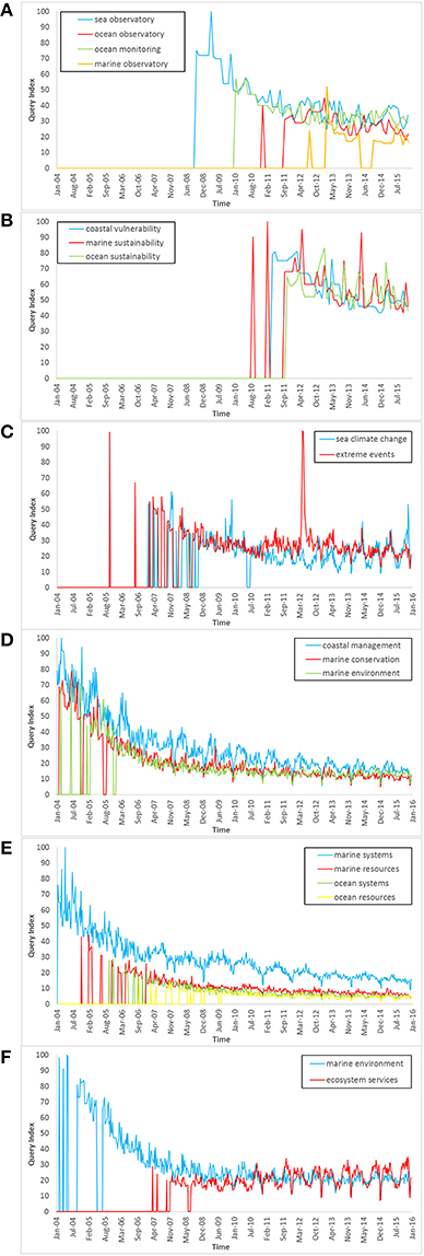
Figure 1. Google Trends' results for expressions related to (A) Ocean Observatories, (B) vulnerability and sustainability, (C) climate change concerns, (D) management and conservation, (E) marine and ocean systems and resources, and (F) environment and economical aspects; Data source: Google Trends (www.google.com/trends).
One of the results of the Ocean Observatories is the generation of regular datasets of variables, some of which are considered as markers of climate change trends, such as the sea surface temperature and salinity, sea level height and pH, among others. There is thus a societal interest in Ocean Observatories related with “climate change concerns.” Interest in “sea climate change” and “extreme events” began around 2008 (Figure 1C).
Results (Figures 1A–C) show societal concerns that seem to have appeared quite recently. They also show a clear decrease in interests in more “classical” expressions, such as “coastal management,” “marine conservation,” and “marine environment” (Figure 1D) and “marine and ocean systems and resources” (Figure 1E). These less modern topics are still on demand, but it seems that environment and conservation issues have made room for economical aspects of nature, like “ecosystem services,” which show an increasing trend (Figure 1F), and climate change concerns.
The RAIA Project
The RAIA Observatory was born in response to the growing need for reliable, high-quality meteorological and oceanographic information, and to provide in situ measurements for the North Western Iberian coast to make operational oceanography feasible (Bastos et al., 2011). Implemented at the Western Iberian coast, RAIA is the result of a common strategy developed by two regions, Galicia and Northern Portugal, with the ambition to reach a deeper understanding of the ocean. The RAIA Observatory started with the RAIA project (2009–2011) and was maintained and further developed in the RAIA.co (2012–2015) and RAIA tec (2013–2015) follow-up projects. These projects allowed different partners (Table 1) with operational, technological and scientific backgrounds and vast experience in marine environment to collaborate across the border.
Table 1. RAIA observatory partners.
Regional Relevance and Specificities
The North-Western Iberian Peninsula coast (Figure 2) is a complex region in terms of ocean dynamics, meteorological conditions, biological aspects, and socio-economical concerns. Its weather characteristics are mainly mediated by the Azores Anticyclone (Lorenzo et al., 2007) which produces predominant northerly and north-westerly winds (Ramos et al., 2011). These winds are most frequent during any period of the year but their highest amplitudes take place during the summer season. The westerly, south-westerly, and southerly winds reach their maximum amplitude during autumn and winter seasons, and can be associated with rainfall and low pressure systems crossing the region.
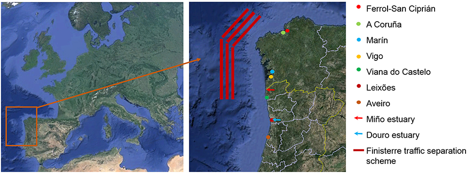
Figure 2. RAIA Observatory region of action and main ports (dots), rivers (arrows), and traffic separation scheme (red lines) (Otero et al., 2014b).
The region is affected by several currents like the Portuguese Current, a branch of the North Atlantic Current (NAC), and the Iberian Poleward Current. The continental shelf is 30–40 km wide between Aveiro and Galicia and its coastal bathymetry presents prominent capes, submarine canyons and promontories that produce hydrodynamic features, such as filaments and eddies (Pinheiro et al., 1996; Peliz et al., 2003; Mason et al., 2006; Relvas et al., 2007; Rossi et al., 2013). The local tides have a semi diurnal regime, with coastal amplitudes ranging between 1 and 1.7 m (Benavent et al., 2009). The waves present a strongly seasonal behavior and main directions from west-northwest and west (Portela, 2008). Significant wave heights vary between 1 and 3 m, with periods below 10 s during summer, and about 5–6 m with periods around 13 s during winter storms. Waves of 9–12 m height have also been measured (Dias et al., 2002). Due to its highly energetic winds, waves and tides, the region has high potential for the installation of renewable energy structures based on wind farms and wave and tidal convertors, which have become particularly prolific in this area.
The Western Iberian rivers produce a recurrent combined plume: the Western Iberian Buoyant Plume (Peliz et al., 2002), which increases the stratification of the water column and produces a vertical retention mechanism that keeps the biological material inshore (Relvas et al., 2007; Martins et al., 2008; Silva et al., 2008a). This phenomenon, which induces a coastal current with a northward transport of water, sediments and biological material, responds mainly to the wind and river runoff and extends along the coast forming a front with the warmer and more saline surface waters (Oliveira et al., 2008; Silva et al., 2008b; Otero et al., 2009). This region also presents upwelling phenomena often observed during the summer months (Álvarez et al., 2008), but also detectable when northerly winds blow, during autumn, and winter seasons (e.g., Álvarez et al., 2003; deCastro et al., 2006; Prego et al., 2007). There is a strong response of the Galician and Northern Portuguese coastal circulation to variations in wind strength and direction (Otero and Ruiz-Villarreal, 2008; Otero et al., 2008, 2009, 2013), with episodes of intrusion of the Douro and Minho river waters into the Galician Rias, particularly during southern wind episodes (Iglesias et al., 2014).
In terms of biology and biodiversity, the region is of particular interest because it is home to a large number of cold- and warm-water species that have their southern or northern distributional range edges along this stretch of coastline. It harbors important fish resources, which sustainable exploitation is of vital interest for both local economy and ecology. The region presents a wide area covered by kelp forests, a highly productive ecosystem that hosts a high diversity of species, feeding them and serving as nursery areas and as a shelter from large predators, and plays an important role in carbon sequestration and in coastal defense by damping waves.
Like in most countries, most of the population lives near the coast, which is heavily urbanized. The region receives an important amount of beach, sailing, and surf tourism during the whole year but mainly during the summer season, due to its geographical setting and climate. The biological, chemical, physical, and dynamical characteristics of the region produce a favorable environment for fisheries and shellfisheries, but also for aquaculture development, particularly in the Galician Rias. There are several important ports for fisheries and transport, such as Ferrol-San Ciprián, A Coruña, Marín, Vigo, Viana do Castelo, Leixões and Aveiro, and the various corridors that constitute the Finisterre Traffic Separation Scheme (Otero et al., 2014b; Figure 2) cross the area under observation by the RAIA Observatory.
The regional specificities related to oceanographic variability, its potential for energy production, natural resources, biological singularities, and social and economic impacts of human activities reinforce the importance of the RAIA Observatory and of its implementation in this particular region.
RAIA Observatory Products and Services
The RAIA Observatory uses a multi-platform approach to collect data. Next to dedicated platforms, such as buoys, moorings, drifting buoys, gliders, UAVs and AUVs, satellite and HF radar data are used, and tailored solutions and methodologies deployed to monitor and map the coastal zone. An extended grid of real-time oceanic, meteorological, and biological observations on the continental shelf has been consolidated (Figure 3) with the installation of new oceanographic buoys and meteorological stations that add to the grid of automated observation platforms maintained by INTECMAR, Meteogalicia, IH, Universidade do Porto and Puertos del Estado. The real-time datasets have been complemented by in situ campaigns realized during the projects, with ship-based water quality sampling, and by other databases available for the area (satellite, HF radar, river flow records, etc.).
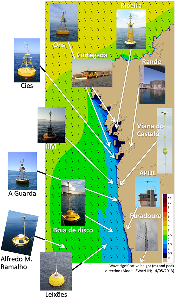
Figure 3. RAIA Observatory monitoring network.
The obtained data are used to implement numerical models developed within the observatory, which constitute one of its most important components. Numerical modeling was performed by several project partners to allow reliable forecasting. The selected models are: the Regional Oceanic Modeling System (ROMS: www.romsagrif.org) and the MOHID water modeling System (http://www.mohid.com/) for oceanic simulations; the Weather Research and Forecasting (WRF: http://www.wrf-model.org/index.php) model for atmospheric forecasting; and the Simulating Waves Nearshore (SWAN: http://swanmodel.sourceforge.net/) model for waves representation. The models were validated and calibrated with the obtained monitoring datasets and produce daily numerical predictions (http://www.marnaraia.org/?page_id = 1037).
Model outputs were used to improve the knowledge about the North Western Iberian coast, performing studies on the general circulation at the Western Iberian Margin (Otero et al., 2011; Nolasco et al., 2013), winter stormy periods (Otero et al., 2013), river plumes (Iglesias et al., 2014), phytoplankton patterns during upwelling events (Rocha et al., 2013), dissolved oxygen dynamics (Reboreda et al., 2015), chlorophyll-a seasonal and interannual variability (Reboreda et al., 2014a) and seasonal plankton production cycles (Reboreda et al., 2014b). Also, lagrangian models were coupled to ROMS to perform studies of general transport pathways (Sala et al., 2013) or oil spill impacts and coastal exposure (Otero et al., 2014a). Specific models were developed and run to represent the morpho-hydrodynamics for small areas such as ports or estuaries (Iglesias et al., 2016), because the previously mentioned models are not suitable for very local studies. An example of the models domains is given in Figure 4.
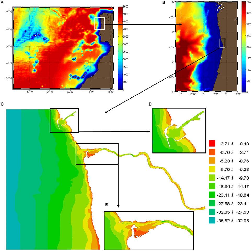
Figure 4. From regional to local modeling. (A,B) Regional domains (ROMS model) (Sala et al., 2013; Iglesias et al., 2014); (C) Local domains for higher resolution modeling (Douro coastal and estuary region) (Iglesias et al., 2016) with zoom performed for (D) Leixões Port, and (E) Douro River mouth. Colors represent the bathymetry (in meters) extracted from GEBCO (http://www.gebco.net/; subfigures A,B) and provided by the IH (subfigure C).
The RAIA Observatory also promotes the development of new and improved monitoring technologies. Several technical challenges were met in order to improve monitoring cost-effectiveness through low-cost platforms that are easy to deploy and maintain, low cost/low power-consumption sensors and systems, new solutions for power supply and harvesting, efficient and affordable data transmission using mixed air/water solutions and innovative sensors (especially to collect biological and chemical data).
This Coastal Observatory developed furthermore techniques to better disseminate the results to the potential end-users. Besides performing workshops dedicated to specific topics such as tourism, water sports, ports, shell fishing, aquaculture, marine resources, or renewable energies, the RAIA observatory developed a strong IT structure to generate an easily accessible data platform. The model results as well as the several databases generated during the projects were filtered and analyzed and a common data platform was created to provide data access thought web and mobile interfaces. Data are provided according to international standards, following OpenDAP, SOS, and WMS protocols (Vila et al., 2012; Rocha et al., 2016).
Meteorological and oceanic forecasts are some of the main end-user products developed within the RAIA Observatory and are available on the project web sites (http://www.marnaraia.org/ and http://www.raia.up.pt/). Several additional tools were developed to provide the end-users with specific information that they need. Generally speaking, the products for the end-users include: hydrodynamic and biogeochemical model outputs; dynamic maps of fronts and eddies; sediment transport model outputs; fecal and pollution distributions; flood maps; offshore wind and wave energy predictions; and forecasts of waves and wind for ports and surfing. To provide an easy and quick access and facilitate the data query, several apps for mobile devices were created (Gomes et al., 2014; Table 2-a–c). Particular products are also available, including specific oceanographic and meteorological predictions for shell fishing sectors (Percegurú, Table 2-d), ports and guilds (Table 2-e), kite-surfing (Table 2-f) and surfing (Table 2-g). The observatory provides tools to: visualize drift trajectories forecasts (Otero et al., 2015; Alavai, Table 2-h), to analyse which regions will be impacted by oil spills in case of an accident and how long it will take to reach specific areas under different wind conditions (Otero et al., 2014a; Table 2-i); to evaluate and calculate the upwelling index (Gonzalez-Nuevo et al., 2014; Table 2-j); and to show the sea surface temperature on the beaches (Table 2-k). Finally, the RAIA Observatory provides services of equipment calibration at the CETMAR laboratory (Table 2-l).
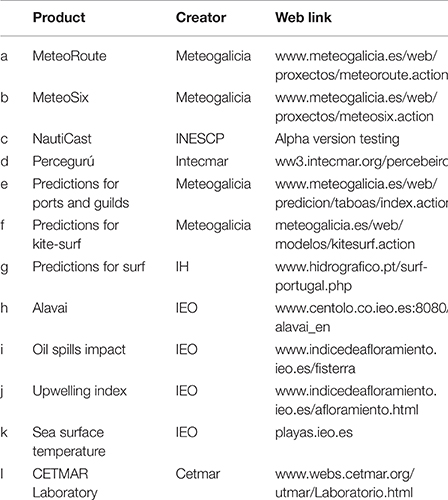
Table 2. List of products for end-users created by the RAIA Observatory partners and their web link.
Discussion and Conclusions
In this work the importance of Coastal and Oceanic Observatories is described, stressing their potential for the assessment of specific regional and local phenomena and patterns, and for the supply of information and insights that are required to satisfy regional and local needs and to improve scientific research.
We found that not only direct stakeholders, international organizations, and local governments are paying more attention to operational oceanography, but that the general public as well reveals an increasing interest in marine topics and observatories, mainly associated with issues linked to vulnerability, sustainability, climate change, and extreme events. Also it was found that conservation issues, such as coastal management or marine conservation, environment systems, and resources, have made room for economical aspects of nature, like ecosystem services.
The RAIA Observatory is an example of a modern and comprehensive ocean monitoring tool, which has proven to be important to produce and deliver reliable, high-quality meteorological, and oceanographic information, and to provide in situ measurements for the North Western Iberian coast that make operational oceanography feasible. On the one hand, the common strategy developed by Galicia and Northern Portugal contributed to a deeper understanding of the North-Western Iberian Peninsula coast, which is a complex region in terms of ocean dynamics, meteorological conditions, biological aspects, and socio-economical concerns. On the other, it allowed the development of a monitoring network, improvement of monitoring technologies, the construction of a strong forecasting system based on several numerical models, the creation of web and mobile interfaces and the generation of specific products to better disseminate the results to the potential end-users. All these utilities were generated considering cost-benefit issues to reduce the generally high and often prohibitive costs of Coastal and Oceanic Observatories, as cost-reduction and an increase in efficiency—as achieved in RAIA—are important issues to guarantee the maintenance of an observatory in the long-term, given the certainty that the information we don't collect today is lost forever.
Author Contributions
All persons who meet authorship criteria are listed as authors, and all authors certify that they have participated sufficiently in the work to take public responsibility for the content, including participation in the concept, drafting, design, analysis, writing, and critically revision of the manuscript. All the authors have approved the final version of the paper to be published and are in agreement to be accountable for all aspects of the work in ensuring that questions related to the accuracy or integrity of any part of the work are appropriately investigated and resolved. Furthermore, each author certifies that this material or similar material has not been and will not be submitted to or published in any other publication.
Conflict of Interest Statement
The authors declare that the research was conducted in the absence of any commercial or financial relationships that could be construed as a potential conflict of interest.
Acknowledgments
The authors want to acknowledge to the RAIA (Interreg IV-A 0313_RAIA_1_E), RAIA.co (Interreg POCTEP 0520_RAIA_CO_1_E) and RAIA tec (Interreg POCTEP 0688_RAIATEC_1_P) projects. This research was partially supported by the Strategic Funding UID/Multi/04423/2013 through national funds provided by FCT—Foundation for Science and Technology and European Regional Development Fund (ERDF), in the framework of the programme PT2020.
References
Aguzzi, J., Mànuel, A., Condal, F., Guillén, J., Nogueras, M., del Rio, J., et al. (2011). The New Seafloor Observatory (OBSEA) for remote and long-term coastal ecosystem monitoring. Sensors 11, 5850–5872. doi: 10.3390/s110605850
Álvarez, I., deCastro, M., Prego, R., and Gómez-Gesteira, M. (2003). Hydrographic characterization of a winter-upwelling event in the Ria of Pontevedra (NW Spain). Estuar. Coast. Shelf Sci. 56, 869–876. doi: 10.1016/S0272-7714(02)00309-8
Álvarez, I., Gómez-Gesteira, M., deCastro, M., and Dias, J. M. (2008). Spatiotemporal evolution of upwelling regime along the western coast of the Iberian Peninsula. J. Geophys. Res. 113, C07. doi: 10.1029/2008JC004744
Bastos, L., Bos, M., Caldeira, R., Couvelard, X., Allis, S., Bio, A., et al. (2011). “Monitoring and forecasting ocean dynamics at a regional scale/Monitorização e previsão da dinâmica oceânica numa escala regional,” in Abstract retrieved in Discussion Papers from KIMERAA 2nd Transnational Seminar (Faro), CIEO - Research Center for Spatial and Organizational Dynamics, University of Algarve.
Benavent, M., Arnoso, J., and Montesinos, F. G. (2009). Regional ocean tide loading modelling around the Iberian Peninsula. J. Geodyn. 48, 132–137. doi: 10.1016/j.jog.2009.09.023
Boyd, I. L., Frisk, G., Urban, E., Tyack, P., Ausubel, J., Seeyave, S., et al. (2011). An international quiet ocean experiment. Oceanography 24, 174–181, doi: 10.5670/oceanog.2011.37
Choi, H., and Varian, H. (2009). Predicting the Present with Google Trends. Technical Report, Google.
Commission of the European Communities (2006). Towards a Future Maritime Policy for the Union: a European Vision for the Oceans and Seas. Green Paper. Brussels; COM 275 final.
Dias, J. M. A., Jouanneau, J. M., Gonzalez, R., Araujo, M. F., Drago, T., Garcia, C., et al. (2002). Present day sedimentary processes on the northern Iberian shelf. Prog. Oceanogr. 52, 249–259. doi: 10.1016/S0079-6611(02)00009-5
deCastro, M., Dale, A. W., Gómez-Gesteira, M., Prego, R., and Álvarez, I. (2006). Hydrographic and atmospheric analysis of an autumnal upwelling event in the Ria of Vigo (NW Iberian Peninsula). Estuar. Coast. Shelf Sci. 68, 529–537. doi: 10.1016/j.ecss.2006.03.004
Eurocean (2004). The Galway Declaration. Available online at: http://www.euroceanconferences.eu/eurocean-2004
Eurocean (2007). The Aberdeen Declaration. Available online at: http://www.euroceanconferences.eu/eurocean-2007
Favali, P., and Beranzoli, L. (2009). EMSO: European multidisciplinary seafloor observatory. Nucl. Instrum. Methods Phys. Res. A 602, 21–27. doi: 10.1016/j.nima.2008.12.214
Gomes, R., Oliveira, M. A., and Carvalho, A. (2014). “Visualização de Dados Oceanográficos em Dispositivos Móveis,” in Abstract Retrieved from Abstracts in 3as Jornadas de Engenharia Hidrográfica (Lisboa).
Gonzalez-Nuevo, G., Gago, J., and Cabanas, J. M. (2014). Upwelling index: a powerful tool for marine research in the NW Iberian upwelling system. J. Oper. Oceanogr. 7, 47–57. doi: 10.1080/1755876X.2014.11020152
Howarth, J., and Palmer, M. (2011). The liverpool bay coastal observatory. Ocean Dynam. 61, 1917–1926. doi: 10.1007/s10236-011-0458-8
Iglesias, I., Couvelard, X., Avilez-Valente, P., and Caldeira, R. M. A. (2014). “NW Iberia shelf dynamics: the river Douro plume,” in Abstract retrieved from Book of Proceedings in 3rd IAHR Europe Congress (Porto).
Iglesias, I., Venôncio, S., Peixoto, R., Pinho, J. L., Avilez-Valente, P., and Vieira, J. (2016). “The douro estuary: modelling comparison for floods prevention,” in Abstract retrieved from Abstracts in 4as Jornadas de Engenharia Hidrográfica (Lisboa).
Isern, A. R., and Clark, H. L. (2003). The ocean observatories initiative: a continued presence for interactive ocean research. Mar. Technol. Soc. J. 37, 26–41. doi: 10.4031/002533203787537285
Jeanson, M., Dolique, F., and Anthony, E. J. (2014). A GIS-based coastal monitoring and surveillance observatory on tropical islands exposed to climate change and extreme events: the example of Mayotte Island, Indian Ocean. J. Coast. Conserv. 18, 567–580. doi: 10.1007/s11852-013-0286-8
Johannessen, J. A., Le Traon, P. Y., Robinson, I., Nittis, K., Bell, M. J., Pinardi, N., et al. (2006). Marine environment and security for the european area: toward operational oceanography. Bull. Am. Meteorol. Soc. 87, 1081–1090. doi: 10.1175/BAMS-87-8-1081
Legler, D. M., Freeland, H. J., Lumpkin, R., Ball, G., McPhaden, M. J., North, S., et al. (2015). The current status of the real-time in situ global ocean observing system for operational oceanography. J. Oper. Oceanogr. 8, 189–200. doi: 10.1080/1755876X.2015.1049883
Lorenzo, M. N., Taboada, J. J., and Gimeno, L. (2007). Links between circulation weather types and teleconnection patterns and their influence on precipitation patterns in Galicia (NW Spain). Int. J. Climatol. 28, 1493–1505. doi: 10.1002/joc.1646
Malone, T. C. (2003). The coastal module of the Global Ocean Observing System (GOOS): an assessment of current capabilities to detect change. Mar. Policy 27, 295–302. doi: 10.1016/S0308-597X(03)00043-5
Martins, I., Silva, A., Santos, A., and Bastos, L. (2008). “Assessing critical runoff values for the generation of a buoyancy induced coastal current off the western Iberian Peninsula,” in Abstracts retrieved from Geophysical Research Abstracts, European Geosciences Union, Vol. 10, (Vienna).
Mason, E., Coombs, S., and Oliveira, P. B. (2006). “An overview of the literature concerning the oceanography of the eastern North Atlantic region,” in Relatórios Técnicos e Científicos, Série Digital 33 (Lisboa: IPIMAR).
Merrifield, M., Aarup, T., Allen, A., Aman, A., Caldwell, P., Bradshaw, E., et al. (2009). “The Global Sea Level Observing System (GLOSS),” in Proceedings of Ocean Obs, Vol. 9, (Venice).
Nolasco, R., Pires, A. C., Cordeiro, N., Le Cann, B., and Dubert, J. (2013). A high-resolution modeling study of the Western Iberian Margin mean and seasonal upper ocean circulation. Ocean Dynam. 63, 1041–1062. doi: 10.1007/s10236-013-0647-8
Ocean US (2002). An Integrated and Sustained Ocean Observing System (IOOS) for the United States: Design and Implementation. Arlington, TX: Ocean US.
Oliveira, A., Santos, A. I., Morgado, A., and Silva, A. J. (2008). “Suspended sediments mineralogical signature-an approach to understand shelf water hydrodynamic,” in Abstract Retrieved from Physical of Estuaries and Coastal Seas (PEC) (Liverpool).
Otero, P., and Ruiz-Villarreal, M. (2008). Wind forcing of the coastal circulation off north and northwest Iberia: comparison of atmospheric models, J. Geophys. Res. 113:C10019. doi: 10.1029/2008JC004740
Otero, P., Ruiz-Villarreal, M., Allen-Perkins, S., Vila, B., and Cabanas, J. M. (2014b). Coastal exposure to oil spill impacts from the finisterre traffic separation scheme. Mar. Pollut. Bull. 85, 67–77. doi: 10.1016/j.marpolbul.2014.06.020
Otero, P., Ruiz-Villarreal, M., García-García, L., González-Nuevo, G., and Cabanas, J. M. (2013). Coastal dynamics off Northwest Iberia during a stormy winter period. Ocean Dyn. 63, 115–129. doi: 10.1007/s10236-012-0585-x
Otero, P., Ruiz-Villarreal, M., García-García, L., Marta-Almeida, M., Cobas, M., González-Nuevo, G., et al. (2011). “Walking on the Sea Side: Modeling and Observational Efforts of the Iberian Margin Ocean Observatory (RAIA),” in Abstract retrieved from OCEANS 2011 IEEE (Santander). doi: 10.1109/Oceans-Spain.2011.6003564
Otero, P., Ruiz-Villarreal, M., González-Nuevo, G., and Cabanas, J. M. (2014a). Operational oceanography, end users, and social network sites. An exploratory analysis. Oceanography 27, 96–105. doi: 10.5670/oceanog.2014.63
Otero, P., Ruiz-Villarreal, M., and Peliz, Á. (2008). Variability of river plumes off Northwest Iberia in response to wind events. J. Mar. Syst. 72, 238–255. doi: 10.1016/j.jmarsys.2007.05.016
Otero, P., Banas, N. S., and Ruiz-Villarreal, M. (2015). A surface ocean trajectories visualization tool and its initial application to the Galician coast. Environ. Model. Softw. 66, 12–16. doi: 10.1016/j.envsoft.2014.12.006
Otero, P., Ruiz-Villarreal, M., and Peliz, Á. (2009). River plume fronts off NW Iberia from satellite observations and model data. ICES J. Mar. Sci. 66, 1853–1864. doi: 10.1093/icesjms/fsp156
Peliz, Á., Dubert, J., Haidvogel, D. B., and Le Cann, B. (2003). Generation and unstable evolution of a density-driven Eastern Poleward Current: the Iberian Poleward Current. J. Geophys. Res. 108, 1978–2012. doi: 10.1029/2002JC001443
Peliz, Á., Rosa, T. L., Santos, A. M. P., and Pissarra, J. L. (2002). Fronts, jets, and counter-flows in the Western Iberian upwelling system. J. Mar. Syst. 35, 61–77. doi: 10.1016/S0924-7963(02)00076-3
Pinheiro, L. M., Wilson, R. C. L., Pena dos Reis, R., Whitmarsh, R. B., and Ribeiro, A. (1996). “The western Iberia margin: A geophysical and geological overview,” in Abstract Retrieved from Proceedings of the Ocean Drilling Program, Vol. 149, eds R. B. Whitmarsh, D. S. Sawyer, A. Klaus, and D. G. Masson (College Station, TX: Ocean Drilling Program, Scientific Results), 3–23.
Portela, L. I. (2008). Sediment transport and morphodynamics of the Douro River estuary. Geo. Mar. Lett. 28, 77–86. doi: 10.1007/s00367-007-0091-1
Prego, R., Guzmán-Zuñiga, D., Varela, M., deCastro, M., and Gómez-Gesteira, M. (2007). Consequences of winter upwelling events on biogeochemical and phytoplankton patterns in a western Galician ria (NW Iberian peninsula). Estuar. Coast. Shelf Sci. 73, 409–422. doi: 10.1016/j.ecss.2007.02.004
Proctor, R., and Howart, J. (2008). Coastal Observatories and operational oceanography: a european perspective. Mar. Techno. Soc. J. 42, 10–13. doi: 10.4031/002533208786842534
Ramos, A. M., Ramos, R., Sousa, P., Trigo, R. M., Janeira, M., and Prior, V. (2011). Cloud to ground lightning activity over Portugal and its association with circulation weather types. Atmos. Res. 101, 84–101. doi: 10.1016/j.atmosres.2011.01.014
Reboreda, R., Cordeiro, N. G. F., Nolasco, R., Castro, C. G., Álvarez-Salgado, X. A., Queiroga, H., et al. (2014a). Modeling the seasonal and interannual variability (2001–2010) of chlorophyll-a in the Iberian margin. J. Sea Res. 93, 133–149. doi: 10.1016/j.seares.2014.04.003
Reboreda, R., Cordeiro, N. G. F., Nolasco, R., Castro, C. G., Álvarez-Salgado, X. A., Queiroga, H., et al. (2015). Oxygen in the Iberian margin: a modeling study. Prog. Oceanogr. 131, 1–20. doi: 10.1016/j.pocean.2014.09.005
Reboreda, R., Nolasco, R., Castro, C. G., Álvarez-Salgado, X. A., Cordeiro, N. G. F., Queiroga, H., et al. (2014b). Seasonal cycle of plankton production in the Iberian margin based on a high resolution ocean model. J. Mar. Syst. 139, 396–408. doi: 10.1016/j.jmarsys.2014.08.004
Relvas, P., Barton, E. D., Dubert, J., Oliveira, P. B., Peliz, Á., da Silva, J. C. B., et al. (2007). Physical oceanography of the western Iberia ecosystem: latest views and challenges. Prog. Oceanogr. 74, 149–173. doi: 10.1016/j.pocean.2007.04.021
Rocha, A., Oliveira, M. A., Freire, F., Montero, P., Vila, B., Iglesias, I.,et al. (2016). “Data discovery mechanisms and metadata handling in RAIA coastal observatory,” in Abstract Retrieved from Abstracts in 4as Jornadas de Engenharia Hidrográfica (Lisboa).
Rocha, C., Cordeiro, N., Nolasco, R., and Dubert, J. (2013). “Numerical modelling of the phytoplankton patterns in an upwelling event off the NW Iberian Margin,” in Abstract retrieved from Proceedings 12th International Coastal Symposium, eds D. C. Conley, G. Masselink, P. E. Russell, and T. J. O'Hare (Plymouth, England). J. Coastal Res. 65, 117–122. doi: 10.2112/si65-021a.1
Rodwell, L. D., Fletcher, S., Glegg, G. A., Campbell, M., Rees, S. E., Ashley, M., et al. (2014). Marine and coastal policy in the UK: Challenges and opportunities in a new era. Mar. Policy 45, 251–258. doi: 10.1016/j.marpol.2013.09.014
Roemmich, D., Johnson, G. C., Riser, S. C., Davis, R. E., Gilson, J., Owens, W. B., et al. (2009). The Argo Program: observing the global ocean with profiling floats. Oceanography 22, 34–43. doi: 10.5670/oceanog.2009.36
Rossi, V., Garçon, A., Tassel, J., Romagnan, J. B., Stemmann, L., Jourdin, F., et al. (2013). Cross-shelf variability in the Iberian Peninsula Upwelling System: impact of a mesoscale filament. Cont. Shelf Res. 59, 97–114. doi: 10.1016/j.csr.2013.04.008
Sala, I., Caldeira, R. M. A., Estrada-Allis, S. N., Froufe, E., and Couvelard, X. (2013). Lagrangian transport pathways in the northeast Atlantic and their environmental impact. Limnol. Oceanogr. 3, 40–60. doi: 10.1215/21573689-2152611
Seim, H. E., Fletcher, M., Mooers, C. N. K., Nelson, J. R., and Weisberg, R. H. (2009). Towards a regional coastal ocean observing system: an initial design for the southeast coastal ocean observing regional association. J. Mar. Syst. 77, 261–277. doi: 10.1016/j.jmarsys.2007.12.016
Silva, A., Martins, I., and Bastos, L. (2008a). “An intermittent coastal current generated by buoyancy and wind forcing,” in Abstracts retrieved from Geophysical Research Abstracts, European Geosciences Union, Vol. 10, (Vienna).
Silva, A., Martins, I., Santos, A., and Bastos, L. (2008b). “NW Iberian coastal current: a feature of extreme freshwater and wind conditions,” in Effects of Climate Change on the World's Oceans International Symposium Book of Abstracts (Gijón)
Taylor, S. M. (2009). Transformative ocean science through the VENUS and NEPTUNE Canada ocean observing systems. Nucl. Instrum. Methods Phys. Res. A Accel. Spectrom. Detect. Assoc. Equip. 602, 63–67. Proceedings of the 3rd International Workshop on a Very Large Volume Neutrino Telescope for the Mediterranean Sea. doi: 10.1016/j.nima.2008.12.019
Keywords: marine observatories, operational oceanography, ocean monitoring, public interest, end-user products, RAIA observatory
Citation: Bastos L, Bio A and Iglesias I (2016) The Importance of Marine Observatories and of RAIA in Particular. Front. Mar. Sci. 3:140. doi: 10.3389/fmars.2016.00140
Received: 23 March 2016; Accepted: 26 July 2016;
Published: 10 August 2016.
Edited by:
Pengfei Xue, Michigan Technological University, USAReviewed by:
Antonio Olita, National Research Council, ItalyMiao Tian, Woods Hole Oceanographic Institution, USA
Copyright © 2016 Bastos, Bio and Iglesias. This is an open-access article distributed under the terms of the Creative Commons Attribution License (CC BY). The use, distribution or reproduction in other forums is permitted, provided the original author(s) or licensor are credited and that the original publication in this journal is cited, in accordance with accepted academic practice. No use, distribution or reproduction is permitted which does not comply with these terms.
*Correspondence: Isabel Iglesias, aXNhYmVsLmlnbGVzaWFzLmZkekBnbWFpbC5jb20=