 Richard G. Lathrop1*
 Jay Odell2Tony MacDonald3Karl Vilacoba3John Bognar1Jim Trimble1Chris Bruce2Gwynn Crichton2Drew Seminara4Jeanne Herb5Matt Campo5
- 1Center for Remote Sensing & Spatial Analysis, Rutgers University, New Brunswick, NJ, United States
- 2The Nature Conservancy, Mid-Atlantic Marine Program, Richmond, VA, United States
- 3Urban Coast Institute, Monmouth University, Long Branch, NJ, United States
- 4EcoTrust, Portland, OR, United States
- 5Edward J. Bloustein School of Planning & Policy, Rutgers University, New Brunswick, NJ, United States
The Mid-Atlantic Regional Council on the Ocean (MARCO) was established in 2009 to enhance the vitality of the region's ocean ecosystem and economy. One of MARCO's first action items was the development of the Mid-Atlantic Ocean Data Portal to serve as an on-line platform to engage stakeholders across the region with the objective of improving their understanding of how ocean resources and places are being used, managed, and conserved. A key component is the Marine Planner, an interactive map-based visualization and decision support tool. These types of on-line tools are becoming increasingly popular means of putting essential data and state-of-the-art visualization technology into the hands of the agencies, industry, community leaders, and stakeholders engaged in ocean planning. However, to be effective, the underlying geospatial data has to be seen as objective, comprehensive, up-to-date and regionally consistent. To meet this challenge, the portal utilizes a distributed network of web map services from credible and authoritative sources. Website analytics and feedback received during the review and comment period of the 2016 release of the Mid-Atlantic Ocean Action Plan confirm that the Data Portal is viewed as integral to this ocean planning process by the MidAtlantic Regional Planning Body and key stakeholders. While not all stakeholders may agree with specific planning decisions, there is broad based agreement on the need for better data and making access to that data widely available.
Background
The past decade has seen expanding interest at state, regional, national, and international levels in undertaking more ecosystem-based and proactive policies to manage marine ecosystems (McLeod et al., 2005; UN Intergovernmental Oceanographic Commission., 2006; Long et al., 2015). In 2010, the United States' first comprehensive National Ocean Policy (NOP) was established by Presidential Executive Order 13547 (2010). The NOP's stated purpose is “[t]o achieve an America whose stewardship ensures that the ocean, our coasts, and the Great Lakes are healthy and resilient, safe and productive, and understood and treasured so as to promote the well-being, prosperity, and security of present and future generations…” The NOP defined nine regional planning areas and set forth a voluntary process for establishment of Regional Planning Bodies (RPB)—partnerships of federal and state agencies with diverse ocean management responsibilities. The RPBs were empowered to develop Regional Ocean Plans following a framework that emphasized cross-sector coordination, public participation and science-based decision making. In the Mid-Atlantic region federal agencies joined with the Mid-Atlantic Regional Council on the Ocean (MARCO) to establish a RPB. MARCO was established in 2009 by the Governors of the five coastal Mid-Atlantic states (Delaware, Maryland, New Jersey, New York, and Virginia) prior to the NOP being developed.
As on the land, translating policy into planning and management decisions in marine situations increasingly calls for an explicitly spatial approach, often referred to as marine spatial planning (Douvere and Ehler, 2009; Katsanevakis et al., 2011; Halpern et al., 2012). One of the key challenges has been determining the spatial overlap among various human uses and the environment and to analyze potential interactions (e.g., synergies or conflicts) among those uses (Longley-Wood, 2016). As one of the fastest growing new uses of the ocean, renewable-energy development (e.g., wind turbines) has been one of the key drivers behind concerns over ocean space allocation (White et al., 2012). Developing place-based understanding on the part of stakeholders so that they can constructively engage in the decision-making process requires the corresponding spatial data infrastructure (SDI) to support it. A SDI is a framework or system that facilitates the exchange and sharing of spatial data and can be described as the underlying infrastructure, often in the form of policies, standards and access networks (National Research Council., 1993). Increasingly, governments around the world are expanding the SDI concept to include coastal and marine areas under their jurisdiction (Strain et al., 2006; Kopke and Dwyer, 2016).
Ocean data portals (sometimes referred to as coastal web atlases) often serve as the core for this marine-focused SDI. An ocean data portal is a publically accessible resource that consolidates available data and enables regional ocean planners and ocean users to visualize and analyze ocean resources and human use information such as fishing grounds, recreational areas, marine wildlife and habitats, shipping lanes, and energy sites, among others. Ocean data portals are designed to support regional ocean planning by facilitating “decision-makers” (i.e., government agency and non-governmental organization personnel), as well as other interested stakeholders and the broader public access to relevant geographic information concerning marine resources and human uses (Longley-Wood, 2016). At the US national level, the ocean data portal MarineCadastre.gov was developed specifically to support renewable energy siting on the U.S. Outer Continental Shelf. One of MARCO's first actions was to develop the Mid-Atlantic Ocean Data Portal (hereafter referred to as the Data Portal) to serve as an on-line platform to engage stakeholders across the region. In addition to MARCO, the Northeast and West Coast regional planning areas have developed regional scale ocean data portals to support their planning efforts. A number of states such as California and Virginia have followed suit. In this paper we briefly describe the architecture of the Mid-Atlantic Ocean Data Portal and assess its role in supporting ocean planning.
Case Study: Mid-Atlantic Ocean Data Portal
A key component of the Mid-Atlantic Ocean Data Portal (http://portal.midatlanticocean.org) is the Marine Planner, an interactive map-based visualization and decision support tool allowing users to combine data in ways that can be tailored to the viewer's area and topics of interest (Figure 1). Typical of web-based geographic information systems (WebGIS) applications (Fu and Sun, 2010), the Marine Planner does not provide the full functionality of a typical desktop GIS, its user interface was designed and tested to lower the bar for technical ability needed to perform simple geospatial query and analysis. The front-end is a web browser-based data visualization application for the end user (Marine Planner) and the back-end is the data support system behind the viewer, including the geospatial data, and the serving of that data into the Marine Planner. The front-end is based on Open Layers 2 (OL2) open source JavaScript programming/coding. The back-end relies on an ESRI-based data management and server system, ESRI ArcGIS Server hosted on a cloud platform.
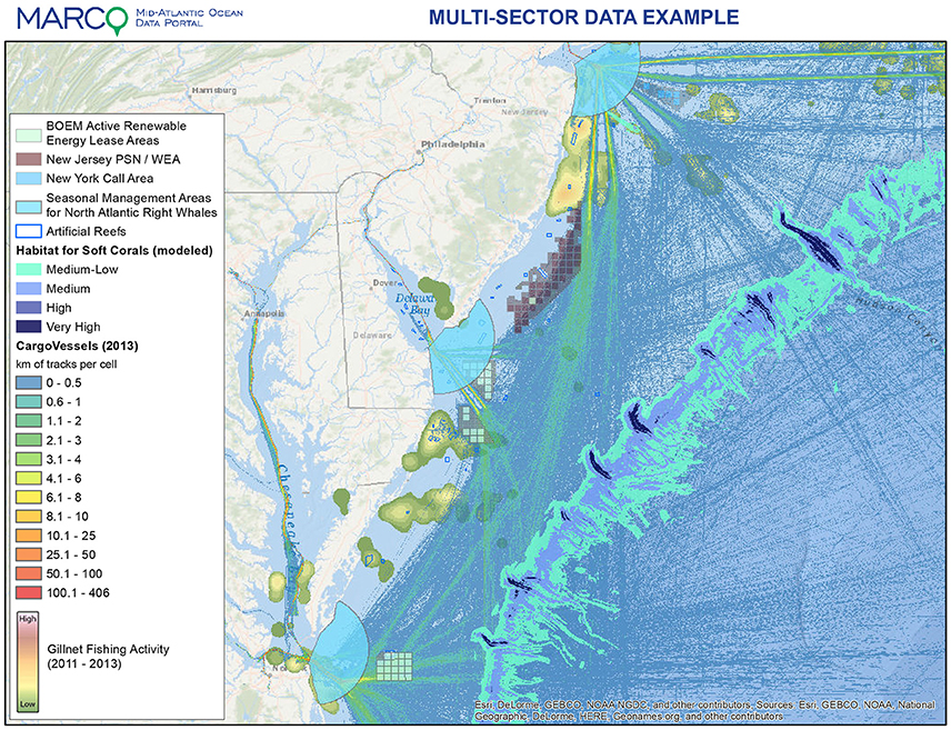
Figure 1. Graphic of the Mid-Atlantic Ocean Data Portal Marine Planner.
A major strength of the Marine Planner is that it brings together data formerly housed in separate locations onto one platform enabling government agencies, industry, community leaders, and stakeholders, as well as the general public, to visualize and analyze ocean resources and human use information. The GIS data are organized around key themes that reflect ocean planning issues in the region, which provide a familiar and accessible entry point to decision makers and the public. The data layers are carefully curated to support simple and efficient access as opposed to creating a comprehensive ocean “data warehouse” that could overwhelm non-technically oriented users. Selection criteria include consideration of ocean planning relevance, methodological rigor, metadata standards and geographic extent (full regional coverage). Three levels of data organization available through drop-down menus provide direct access to over 150 spatial data layers and about 3,000 additional layers via user queries. The data are organized hierarchically under major themes, layers and sub-layers for ease of navigation. The associated Data Catalog provides users with information about the various GIS data layers, access to formal metadata, data download links and Web Map Services URLs. In addition to providing interactive visualization capability, Marine Planner includes powerful features for customizing and sharing map layer views.
As a means of informing users about the Portal and engaging the public in the ocean planning process, the Portal also includes a News section with frequent additions of stories to highlight recently added data layers, tutorials for using new Portal features and upcoming events. Visitors to the Portal's home page first encounter a rotating selection of “Ocean Stories” featuring in-depth content on diverse regional ocean topics with stakeholder interviews and direct links to relevant Marine Planner data layers. Monthly webinars are developed, advertised and held to address specific user needs, and archived webinars are provided on the Portal as training resources for end users.
Ocean planning in the Mid-Atlantic region reached a new milestone with the release of the Mid-Atlantic Regional Ocean Action Plan (OAP) on July 6, 2016 (OAP, 2016). Through the OAP, the RPB has two primary goals: (1) Promote ocean ecosystem health, functionality, and integrity through conservation, protection, enhancement, and restoration; and (2) Plan and provide for existing and emerging ocean uses in a sustainable manner that minimizes conflict, improves effectiveness and regulatory predictability, and supports economic growth. The OAP did not undertake a spatial zoning process, drawing lines on the map, but rather established 11 guiding principles for future planning, which it defines as “basic or essential qualities or elements determining the intrinsic nature or characteristic behavior of regional ocean planning.” The OAP focuses on informing and coordinating interagency and inter-jurisdictional decision making under existing regulatory and statutory authorities, as the RPB itself does not have any regulatory authority. Given that there is no single entity responsible for comprehensive, integrated stewardship, in many respects the Data Portal serves as one of the few tangible manifestations of MARCO, the RPB and the Mid-Atlantic Ocean region. Throughout the plan the Portal is highlighted (236 mentions in 138 pages) as a hub that is central to the planning process and agencies are required to consult it as a non-exclusive source of information and guidance before making both major and minor ocean permitting and management decisions.
Corresponding with the July 6–September 6 comment period on the draft OAP, a series of public listening sessions were held with one session in each of the five MARCO states. The web site analytics showed an average of over 1,100 sessions a month with ~600 users or 2 sessions per user (Table 1). Interestingly, the amount of usage appeared to be comparatively consistent over the time period with no major spikes of activity related to the OAP public comment period. In composite, the Marine Planner (at 24%) and associated Data Catalog (19%) accounted for 43% of the site traffic (Table 1). As expected, four of the five MARCO states (New Jersey, Virginia, New York and Maryland) along with the District of Columbia (where key federal agencies such as NOAA and BOEM are located) showed the greatest amount of usage. Examination of the top theme and layer activations indicated the wide diversity of interests on the part of the portal users. Marine Life and Fishing represented the top two themes that were accessed. The individual layer that received the greatest numbers of hits was Artificial Reefs (under the Fishing theme) closely followed by Danger Zones & Restricted Areas. Other top layers included the BOEM Wind Planning Areas and BOEM Active Renewable Energy Lease Areas reflecting the importance of this issue to a number of MARCO stakeholders. During the plan comment period, we learned of many examples of how the Portal is already being used by state and federal agency staff and many others. These uses include the United States Coast Guard's efforts to design safer shipping lanes, recreational and commercial fishermen evaluating potential regulation changes, development of marine wildlife survey proposals and elementary and high school teachers incorporating the Portal into lesson plans to increase ocean literacy.
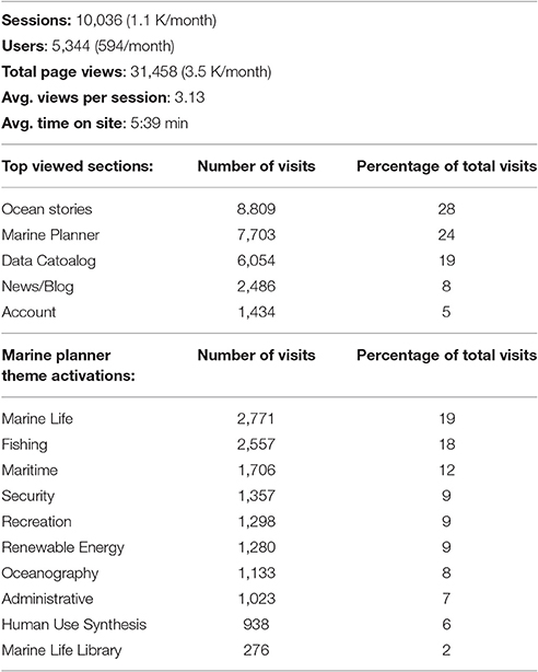
Table 1. Portal Analytics March 8-December 8, 2016.
Conclusions
In response to the 2010 NOP, a number of regions embarked on regional scale ocean planning efforts. In MARCO's case, the underlying goals were to improve understanding of how ocean resources and places are being used, managed, and conserved and to promote participation in coastal and marine planning and decision-making. MARCO recognized the need to use online technology to augment their public engagement well beyond what was possible via face-to-face workshops and meetings. In many respects, these goals fall under the broader umbrella of Public Participation Geographic Information Systems (PPGIS). PPGIS pertains to the use of geographic information systems (GIS) to broaden public involvement in policymaking and implicitly assumes that extending the use of geospatial information to all relevant stakeholders will lead to better policy and decision-making (Sieber, 2006). MARCO as well as the broader ocean planning community has taken this message to heart with significant efforts and financial resources expended to develop ocean data portals as a means to ensure data accessibility with the expectation that this data accessibility enhances the transparency of the planning process, arguably an essential factor for ocean planning success. While not all stakeholders may agree with specific planning or use decisions, there is broad based agreement on the need for better data and making access to that data widely available.
In her review of US ocean data portals, Longley-Wood (2016) outlined a number of best practices for developing and maintaining ocean data portals. These data portals, including the MidAtlantic Ocean Data Portal, share a number of essential characteristics in that they are ocean-focused, map-based and publicly accessible, as well include features and functions such as interactive mapping, shareable data and data organized by theme. Based on our experience with the development and application of the MidAtlantic Portal, we strongly concur with Longley-Wood (2016) on the need for: (1) accommodating a diverse user group; (2) stakeholder data vetting and review; and (3) integration with the planning effort. We found that the transparency of the data and ready access to metadata were critical both to building the trust of stakeholder groups, and ensuring decision makers could easily understand and evaluate data sources, strengths, and caveats. This trust building required extensive in-person one-on-one interaction with a variety of stakeholder groups across the region. One challenge related to this was the development and incorporation of human use data, from shipping to undersea cables to commercial and recreational fishing. Interaction with the broad array of ocean user groups was much more positive when they believed that there was a good faith effort to map and include their uses and resource interests in the Data Portal. Lastly, any visualization and decision support tool will fail to engender widespread adoption if it is too complex; thus development of these tools requires an iterative design process that readily incorporates user feedback followed by extensive training and personal outreach.
Any ocean data portal should be considered a work in progress; we expect to learn much more about the Portal's value to support ocean planning and how to further improve it during OAP implementation. We strongly concur with Kopke and Dwyer (2016) on the critical importance of identifying potential audiences at the start of a data portal/web atlas development process and to remain engaged with them throughout. Efforts will continue to maintain and improve the Portal's map layers and functionality, and to institutionalize and automate the data updates needed to keep the Portal current and useful. A key to long term success will be continued coordination between MARCO and BOEM's MarineCadastre, as well as with other state and regional ocean data portals, to promote more seamless data integration and information exchange across state, Tribal, regional and federal levels of jurisdiction.
Author Contributions
RL primary author and project co-PI. JO secondary author and project co-PI. TM secondary author and project PI. KV secondary author, responsible for Google Analytics. JT application programmer section on fishing Data. JB and CB application analyst and graphics production. GC tertiary author, section on Coast Guard/NASCA use cases. DS application programmer, responsible for Google Analytics. JH tertiary author and project co-PI, section on OAP. MC tertiary author, section on Coast Guard/NASCA use cases.
Funding
Virginia CZM grant funds were awarded to The Nature Conservancy for two years to leverage their experience in developing the North Atlantic Marine Eco-Regional Assessment.
Conflict of Interest Statement
The authors declare that the research was conducted in the absence of any commercial or financial relationships that could be construed as a potential conflict of interest.
Acknowledgments
The MARCO Data Portal was developed in collaboration between MARCO (in particular Kate Morrison and Laura McCay), by the Urban Coast Institute of Monmouth University, Rutgers University Center for Remote Sensing & Spatial Analysis and the Bloustein School of Planning and Policy, The Nature Conservancy's Mid-Atlantic Marine Program (Alfonso Lombana assisted in outreach and communications) and EcoTrust/Point 97 (in particular, Charles Steinback, Scott Fletcher, and Tim Welsh), with considerable assistance in coordination and data development provided by NOAA Office of Coastal Management (with a special thanks to Megan Treml and Darlene Finch), the US Coast Guard and other agency partners participating in the MidAtlantic RPB. This consortium has been funded by NOAA and the Gordon and Betty Moore Foundation. The Portal was initially conceived and a precursor was developed by The Nature Conservancy and funded by the Virginia Coastal Zone Management Program in 2008. We also want to thank the contributions of two reviewers in strengthening this manuscript.
References
Douvere, F., and Ehler, C. N. (2009). New perspectives on sea use management: initial findings from European experience with marine spatial planning. J. Environ. Manage. 90, 77–88. doi: 10.1016/j.jenvman.2008.07.004
Halpern, B. S., Diamond, J., Gaines, S., Gelcich, S., Gleason, M., Jennings, S., et al. (2012). Near-term priorities for the science, policy and practice of Coastal and Marine Spatial Planning (CMSP). Mar. Policy 36, 198–205. doi: 10.1016/j.marpol.2011.05.004
Katsanevakis, S., Stelzenmüller, V., South, A., Sørensen, T. K., Jones, P. J. S., Kerr, S., et al. (2011). Ecosystem-based marine spatial management: review of concepts, policies, tools, and critical issues. Ocean Coast. Manage. 54, 807–820. doi: 10.1016/j.ocecoaman.2011.09.002
Kopke, K., and Dwyer, N. (Eds.). (2016). ICAN – Best practice guide to Engage your Coastal Web Atlas User Community. Paris: Intergovernmental Oceanographic Commission of UNESCO (IOC Manuals and Guides, 75). 35 pp. (English) (IOC/2016/MG/75).
Long, R. D., Charles, A., and Stephenson, R. L. (2015). Key Principles of marine ecosystem-based management. Mar. Policy 57, 53–60. doi: 10.1016/j.marpol.2015.01.013
Longley-Wood, K. (2016). Creating and Using Data Portals to Support Ocean Planning: Challenges and Best Practices from the Northeast United States and Elsewhere. SeaPlan. Available online at: http://www.seaplan.org/wp-content/uploads/Creating-and-Using-Data-Portals-to-Support-Ocean-Planning-FINAL-1.pdf.
McLeod, K. L., Lubchenco, J., Palumbi, S. R., and Rosenberg, A. A. (2005). Scientific Consensus Statement on Marine Ecosystem-Based Management. Signed by 221 Academic Scientists and Policy Experts with Relevant Expertise and Published by the Communication Partnership for Science and the Sea. Available online at: http://compassonline.org/?q=EBM.
National Research Council. (1993). Toward a Coordinated Spatial Data Infrastructure for the Nation. Washington, DC: National Acadmy Press.
OAP (2016). Mid-Atlantic Regional Ocean Action Plan. (OAP). Available online at: https://www.boem.gov/Ocean-Action-Plan/.
Presidential Executive Order 13547 (2010). Stewardship of the Ocean, Our Coasta, and the Great Lakes. Available online at: https://obamawhitehouse.archives.gov/the-press-office/executive-order-stewardship-ocean-our-coasts-and-great-lakes.
Sieber, R. (2006). Public participation geographic information systems: a literature review and framework. Ann. Assoc. Am. Geogr. 96, 491–507. doi: 10.1111/j.1467-8306.2006.00702.x
Strain, L., Rajabifard, A., and Williamson, I. (2006). Marine administration and spatial data infrastructure. Mar. Policy 30, 431–441. doi: 10.1016/j.marpol.2005.03.005
UN Intergovernmental Oceanographic Commission. (2006). VISIONS FOR A SEA CHANGE: Report of the First International Workshop on Marine Spatial Planning UNESCO Headquarters. Paris: UN Intergovernmental Oceanographic Commission, and the Man and the Biosphere Programme.
Keywords: marine spatial planning, marine spatial data infrastructure, geographic information systems (GIS), WebGIS, MARCO, spatial data access and sharing
Citation: Lathrop RG, Odell J, MacDonald T, Vilacoba K, Bognar J, Trimble J, Bruce C, Crichton G, Seminara D, Herb J and Campo M (2017) The Role of Mid-Atlantic Ocean Data Portal in Supporting Ocean Planning. Front. Mar. Sci. 4:256. doi: 10.3389/fmars.2017.00256
Received: 10 May 2017; Accepted: 26 July 2017;
Published: 08 August 2017.
Edited by:
Brett Favaro, Memorial University of Newfoundland, CanadaReviewed by:
Rochelle Diane Seitz, Virginia Institute of Marine Science, United StatesEdward Jeremy Hind-Ozan, Cardiff University, United Kingdom
Copyright © 2017 Lathrop, Odell, MacDonald, Vilacoba, Bognar, Trimble, Bruce, Crichton, Seminara, Herb and Campo. This is an open-access article distributed under the terms of the Creative Commons Attribution License (CC BY). The use, distribution or reproduction in other forums is permitted, provided the original author(s) or licensor are credited and that the original publication in this journal is cited, in accordance with accepted academic practice. No use, distribution or reproduction is permitted which does not comply with these terms.
*Correspondence: Richard G. Lathrop, bGF0aHJvcEBjcnNzYS5ydXRnZXJzLmVkdQ==