 Meadhbh Moriarty
 Simon P. R. Greenstreet1
 Jens Rasmussen
- 1Marine Scotland Science, Marine Laboratory, Aberdeen, United Kingdom
- 2School of Geography and Environmental Sciences, Ulster University, Coleraine, United Kingdom
- 3Wageningen Marine Research, IJmuiden, Netherlands
In Europe, introduction of the Marine Strategy Framework Directive (MSFD) represents formal, legally-binding, adoption of ecosystem-based management (EBM) across most European waters. Member States of the European Union have invariably nominated their groundfish surveys as part of the marine monitoring programs required under the MSFD. Groundfish surveys were originally intended to provide fisheries independent abundance indices for commercially valuable species to support fisheries stock assessments and fisheries management. However, early studies, primarily intended to make the case for the need for EBM, exposed these data to a broader range of uses and highlighted various data quality issues. Individual scientists, pursuing personal research agendas, addressed these as each thought best. This informal approach to assuring data quality is not sufficient to support formal assessments of fish species status and fish community status required under legally-mandated EBM, such as the MSFD, because quality audit, formal logging of issues identified, and remedial measures taken, is often lacking. Groundfish survey data, needed to implement legally-mandated EBM, should be subjected to a formal Quality Assurance–Quality Audit (QAQA) process to ensure that they are properly fit for purpose. This paper describes a QAQA process applied European groundfish survey data to ensure their adequacy to support MSFD needs and considers how this process might be taken forward in the future.
Introduction
In assessing the state of marine ecosystems in European waters, data are being used to address issues for which the original survey design is potentially inadequate. In Europe, fisheries independent groundfish surveys were originally intended to sample commercial fish species populations to support formal stock assessments under the European Union’s (EU) Common Fisheries Policy (CFP). More recently, groundfish survey data have been used to address questions relating to, for example, the status of populations of rarer, commercially valuable species for which data are too sparse to support full formal stock assessment (Honey et al., 2010; Needle, 2015), assessing the impact of fishing mortality on populations of non-target, non-commercial fish species (Greenstreet and Rogers, 2000; Greenstreet et al., 2012b), and for monitoring and assessing the state of the broader fish community to support implementation of ecosystem-based management (EBM) (Jennings, 2004; Shin and Shannon, 2010; Shin et al., 2010a,b; Greenstreet et al., 2011).
Early use of these groundfish survey data, beyond simply meeting commercial stock assessment needs, focused on developing indicators of the state of fish populations and communities (Greenstreet and Rogers, 2006; Greenstreet et al., 2011, 2012a,b), using these to demonstrate the impact of fishing on the state of fish components of marine ecosystems (Greenstreet and Hall, 1996; Greenstreet et al., 1999; Jennings et al., 1999; Garrison and Link, 2000; Shin et al., 2005), and generally making the case for the need for EBM (Jennings, 2005; Jennings and Rice, 2011). However, data quality issues soon emerged (Daan, 2001; ter Hofstede and Daan, 2006, 2008). These mainly related to non-commercial species, suggesting a higher level of attention, to “quality assurance and quality audit” (QAQA), in respect of data required for formal CFP stock assessments. Scientists involved in research to develop EBM were aware of these data QAQA issues and applied protocols to address this (e.g., Greenstreet et al., 1999; ter Hofstede et al., 2010; Fung et al., 2012). However, approaches adopted by different researchers varied, resulting in differing interpretations of multiple, different “data products,” all purporting to represent the same source data set. This raised the question as to whether these different QAQA methods produced data products that were sufficiently different as to affect research outcomes (Fung et al., 2012)?
The Marine Strategy Framework Directive (MSFD) represents formal adoption of EBM in waters under EU jurisdiction (European Commission [EC], 2008, 2010, 2017) it requires monitoring and assessment of all components of marine ecosystems. Many EU Member States (MS) have designated their groundfish surveys to fulfill legally mandated EBM requirements. Despite the issues with survey design, European groundfish survey data must therefore now meet the multiple objectives of different users. Fisheries scientists will continue to use groundfish survey data for CFP stock assessment purposes, but marine ecologists will now also need access to the same data to monitor and assess the state of the broader fish community. In addition, these data will also be drawn on to support academic research and strategic planning for other marine industries. Whilst potentially adequate to meet fisheries stock assessment purposes, critically groundfish survey data currently stored in the International Council for Exploration of the Seas (ICES) “database for trawl surveys” (DATRAS) portal may not be “fit for purpose” when used for assessing the status of the broader fish community, and all species therein. It is no longer appropriate that the QAQA process be left in the hands of individual scientists; the existence of multiple data products and the possibility that choice of data product could confuse assessment and policy decisions by EU policy makers. Compounding the issue, different indicators will potentially be used to assess fish community status and the status populations of individual species making up these communities thereby confusing the interpretation of the survey results (e.g., Bundy et al., 2010; Shin et al., 2010a; Greenstreet et al., 2012a,b; Tam et al., 2017). It would be unsatisfactory if the different indicator trends were not directly comparable because data sets on which analyses were performed were not identical. Such a situation could undermine the basis for integration of individual indicator assessment outcomes to produce overall assessments of fish components of marine ecosystems (Borja et al., 2014, 2016; Dickey-Collas, 2014; Link and Browman, 2014; Walther and Möllmann, 2014).
Assessments that constitute a legal obligation, such as meeting MSFD requirements, should be based on definitive data products that have been subjected to a rigorous QAQA process, which incorporate fully defined protocols to establish data quality and consistency, with every step of this process fully documented. These data products would then form the basis for all subsequent assessments. Such data products would represent “snapshots” within an ongoing dynamic process in which new data submissions, updates and revisions occur continuously. Here such a procedure is described for groundfish surveys.
Overview of the Groundfish Surveys
Nineteen groundfish surveys were subjected to a comprehensive QAQA protocol (Greenstreet and Moriarty, 2017a,b; Moriarty et al., 2017). Source data were downloaded from the ICES DATRAS portal (International Council for Exploration of the Seas [ICES], 2017) where available, or where not available on DATRAS, data were provided directly by the national institutes involved. The aim was to produce a suite of definitive, fully QAQA, groundfish survey “data products” that could provide the basis for assessments of the groundfish component of marine ecosystems across the entire Northeast Atlantic region. These surveys provide a temporal coverage of between 10 and 35 years and a spatial coverage spanning three of the four subregions of the Northeast Atlantic region defined in Article 4 of the MSFD in the Greater North Sea (including the Kattegat and English Channel), the Celtic Seas, and the Bay of Biscay and Iberian Coast (European Commission [EC], 2008). None of the surveys considered here operated in a fourth subregion defined in the MSFD, i.e., the Macaronesian biogeographic region (European Commission [EC], 2008). However, data from surveys carried out on sea mounts and plateaus beyond the continental shelf, and therefore outside the Celtic Seas and Bay of Biscay and Iberian Coast subregions, were considered, so a fourth subregion, given the OSPAR region V name, the Wider Atlantic Ocean, was included (Figure 1A).
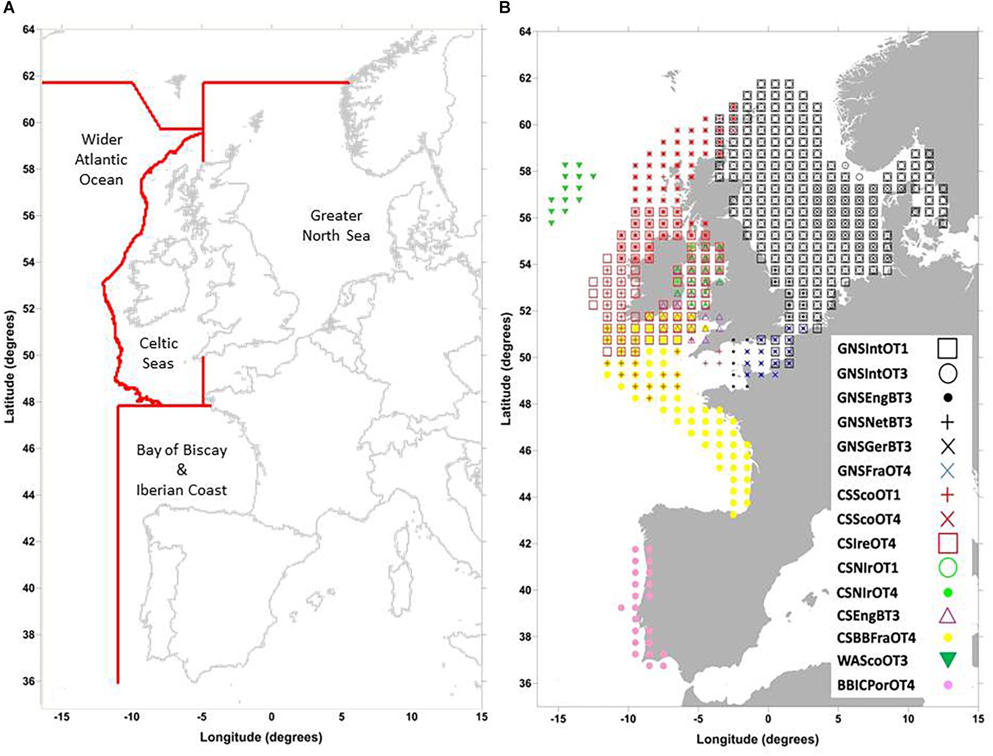
Figure 1. (A) The sub-regions of the North-east Atlantic Ocean Region; The Greater North Sea (including the Kattegat and English Channel), the Celtic Seas, the Bay of Biscay and Iberian Coast, and the Wider Atlantic Ocean (Shapefile source: OSPAR website). (B) Survey coverage of the 15 published datasets across the Northeast Atlantic See Table 1 for explanation of survey acronyms.
Bottom trawl surveys carried out in the Northeast Atlantic have involved fourteen fisheries research vessels using either otter trawls or beam trawls with various rigging configurations and catch efficiencies (International Council for Exploration of the Seas [ICES], 2009, 2012, 2013, 2015). Survey time-series duration varied; some, e.g., The North Sea First Quarter otter trawl survey, started in the 1960s, others as late as the early 2000s (International Council for Exploration of the Seas [ICES], 2012). Because of their large geographic size, often including several national jurisdiction areas, no single MSFD sub-region in the Northeast Atlantic has been monitored by any single groundfish survey across its entirety. Table 1 lists the 19 surveys processed to date to derive the Groundfish Survey Monitoring and Assessment (GSMA) data products, provides their respective product acronyms, and includes basic information regarding each survey. Fully QAQA data products were not published for the four Spanish surveys because only commercial species’ data were available from DATRAS; data for non-commercial species were provided directly from the national data provider (NDP) and had not therefore passed through DATRAS upload data checks. Figure 1B illustrates the geographical coverage provided by the remaining 15 published QAQA survey data sets.
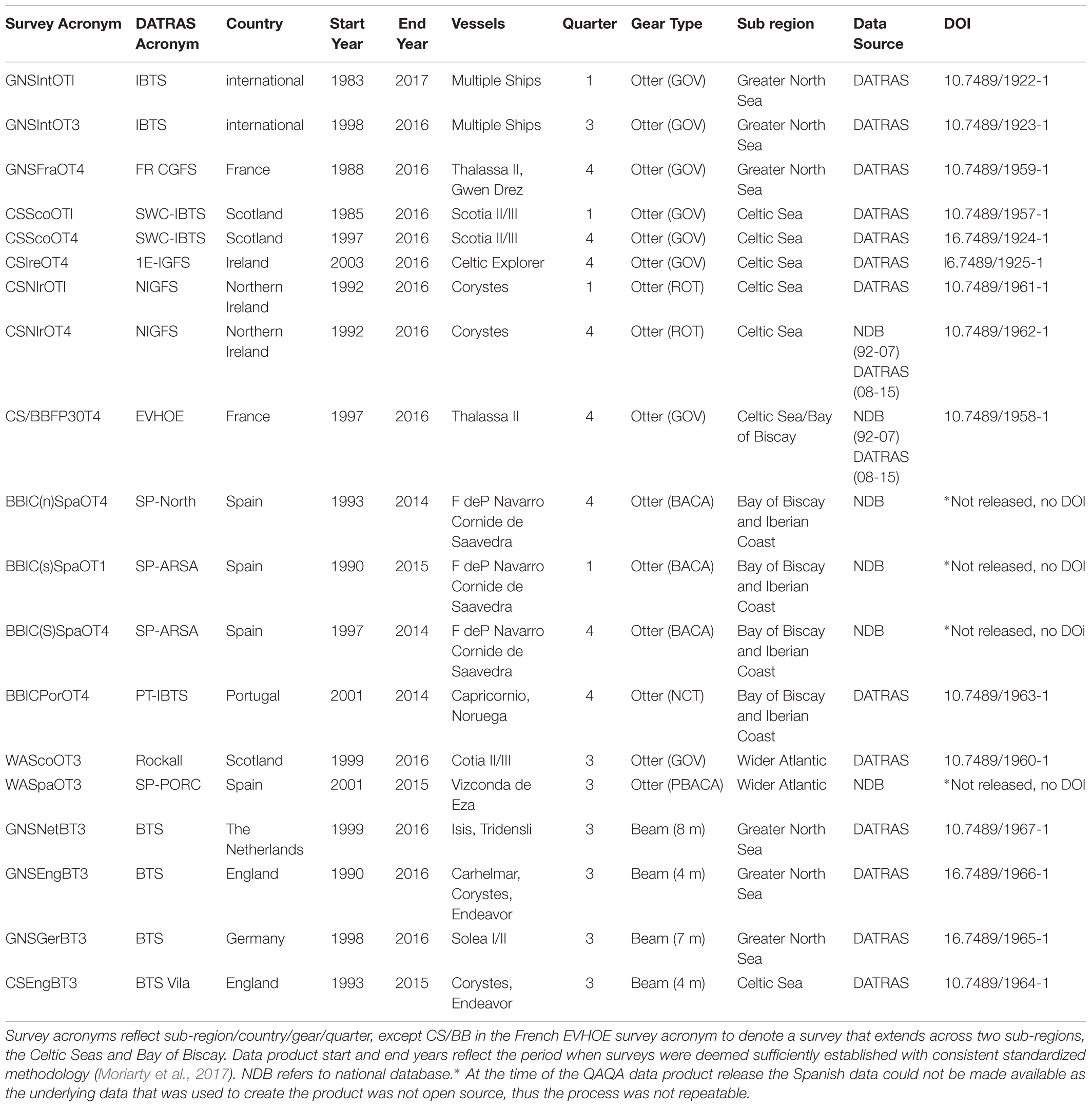
Table 1. List of individual surveys considered in the derivation of the OSPAR Groundfish Survey Monitoring and Assessment data products.
Data Quality Assurance and Audit
The CFP sets out key principles for data: e.g., accuracy, reliability, and timeliness, avoidance of duplication through improved coordination, safe storage in data base systems, and improved availability (European Commission [EC], 2013). The first step in deriving fully QAQA data products for each survey was to define their “standard monitoring programs” (Moriarty et al., 2017), excluding trawl samples collected with non-standard trawl gears, with non-standard tow durations, or before a defined survey protocol had been fully established. For example, first quarter (Q1) groundfish survey data held on DATRAS included data from 1966 onward, but the modern day Q1 International Bottom Trawl Survey (IBTS) only really became established from 1983 onward, when all vessels involved followed a defined sampling protocol using the same GOV trawl gear towed for either 30 or 60 min. Examination of the data suggested that tow durations of 15, 20, 30, and 60 min were all deemed acceptable in the various survey protocols. Consequently, samples with tow durations of 13 to 66 min were all retained as part of the survey “standard monitoring programs,” but samples of shorter or longer tow duration were deemed non-standard and excluded. Data deemed part of each survey’s “standard monitoring program” were then processed following the protocol summarized in Figure 2 to derive the eventual GSMA data products (green box). The three blue oval steps constitute the main quality assurance part of the protocol; individual processes contained in these steps are summarized in Table 2. The orange and mauve “review” box steps, along with the detailed documentation describing the whole QAQA protocol (Greenstreet and Moriarty, 2017a,b; Moriarty et al., 2017), constitute the quality audit part. The extent to which different surveys were affected by different data quality issues varied, with older surveys being most susceptible. A subset of the “standard monitoring program” data products was also derived, consisting only of data collected from within a “standard survey area.” To be part of the “standard survey area,” ICES statistical rectangles had to be sampled in at least 50% of years that a survey was undertaken and in at least one year in the two periods at the start and end of the time series, each constituting at least 20% of the survey duration. Thus, for rectangles to be included in the “standard survey area” of a survey running 20 years from 1996 to 2016, they would have to be sampled in at least 10 years, and at least once in the two 4 years periods 1996 to 1999 and 2013 to 2016.
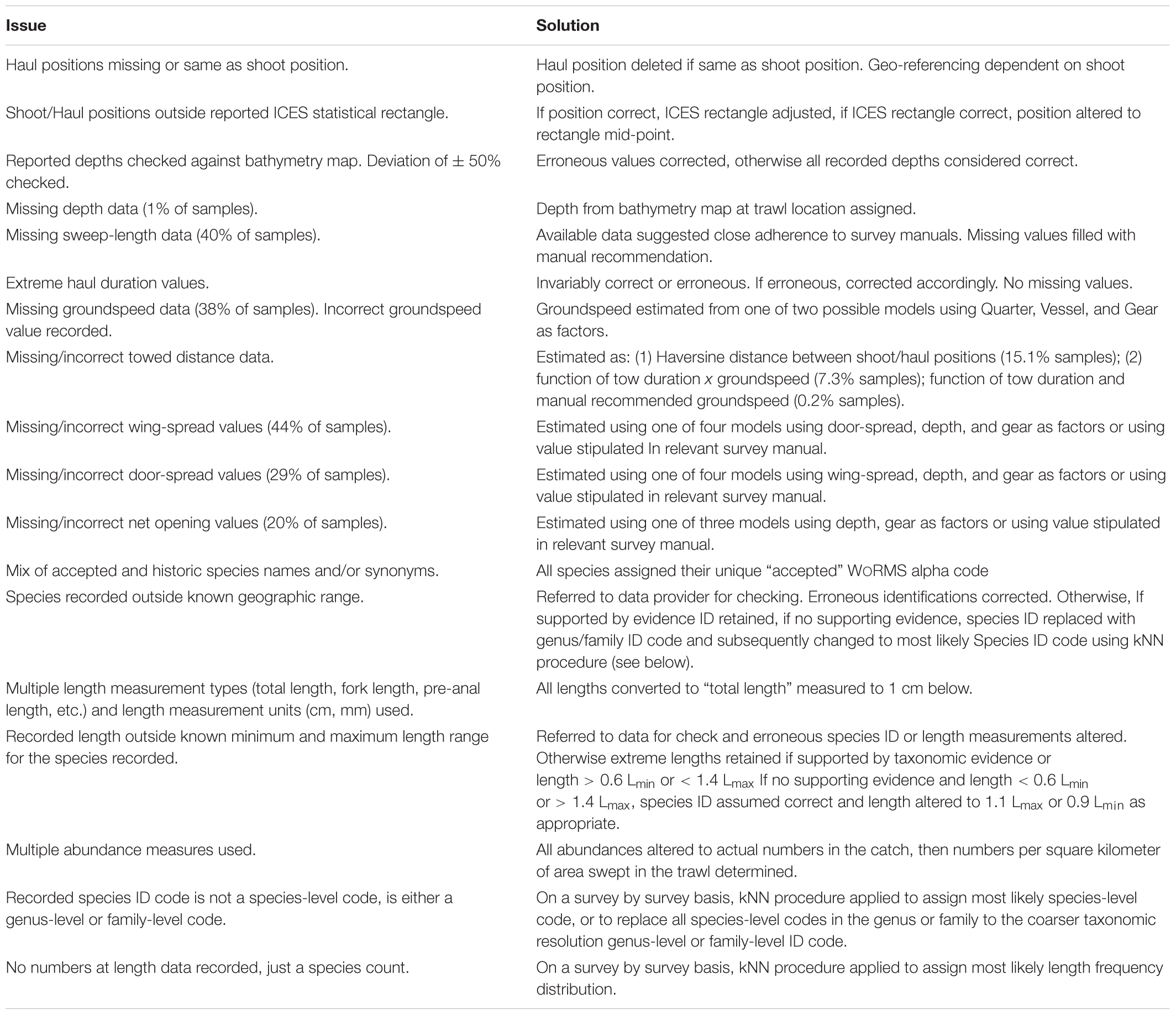
Table 2. Summary of issues identified in the groundfish survey data stored on the DATRAS portal or on national databases and approaches adopted to address these.
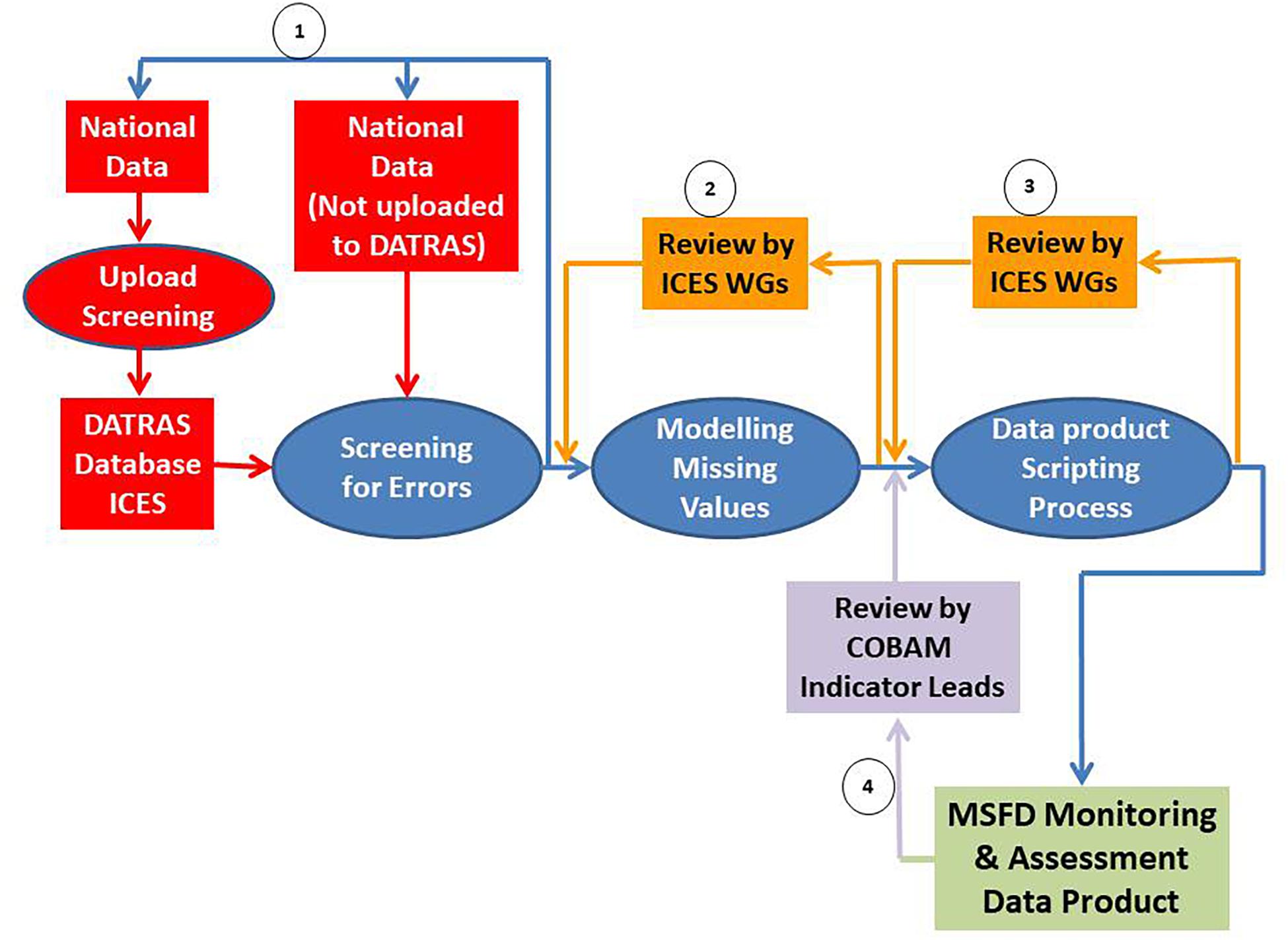
Figure 2. Overview of the groundfish survey monitoring and assessment process relevant to the ICES community. Numbers highlight the different feedback loops following consultation with national data providers (1), ICES Working Groups (2 and 3) and indicator leads (4).
The screening process involved examining parameter values for outlier and missing values. Where values were absent, the information was usually never recorded in the first place, models were developed for each parameter so that missing values could be filled by modeled estimates (Moriarty et al., 2017). Potential data errors were referred back to relevant NDPs for checking (feedback loop 1, Figure 2). Three outcomes were possible: the datum was confirmed to be correct and simply an outlier or the datum was deemed to be either “erroneous” or “incorrect.” “Erroneous data” were a consequence of imperfect data archiving: a typo. These were corrected simply by editing the archived values and re-uploading the revised national data to DATRAS. “Incorrect data” were more difficult to rectify; here archived values matched original values recorded at source. If mistakes had occurred, they happened at source and it was no longer possible to establish whether the value in question was in fact a data error or a correct but outlier value. In these instances it was necessary to decide whether the value in question had sufficient credibility as to be possible, or whether the recorded value was so unlikely that it must be considered wrong. Clear criteria were defined to underpin such decisions, based on expert judgment from the ICES survey working groups, the OSPAR indicator leads and the authors. Where the datum was deemed to be “incorrect,” so extreme an outlier as to not be possible, these data were deleted and a “missing value” procedure employed to replace them with modeled estimates (Moriarty et al., 2017).
Replacing “incorrect” and “missing” values in this way was preferable to the alternative of simply deleting the records concerned. Firstly, individual parameter values often affected other data. For example parameter values such as trawl sample tow distance, if deleted would have resulted in the deletion of all data for that sample with the consequent loss of a considerable amount of “good” information. Secondly, deletion of missing or incorrect data would impart bias. For example, if species length data was absent and only count data available, deleting the data for that species would bias resulting estimates of species diversity. Replacing such missing data with modeled estimates might at worst impart noise, rather than bias. Thirdly, missing or incorrect data was more common in the early years of most surveys; deletion of these data could have compromised time series longevity. At each stage of the QAQA process the action taken to infill “incorrect” and “missing” values was labeled with an identifier tag, these datasets can be made available to an end user wishing to interrogate the data further. As an example of the criteria and methodology used in the QAQA protocol described in Moriarty et al. (2017), the process for assessing the reliability of recorded towed distance values, along with the criteria for correcting erroneous values, replacing incorrect values and estimating values where this information was missing is illustrated in Figure 3.
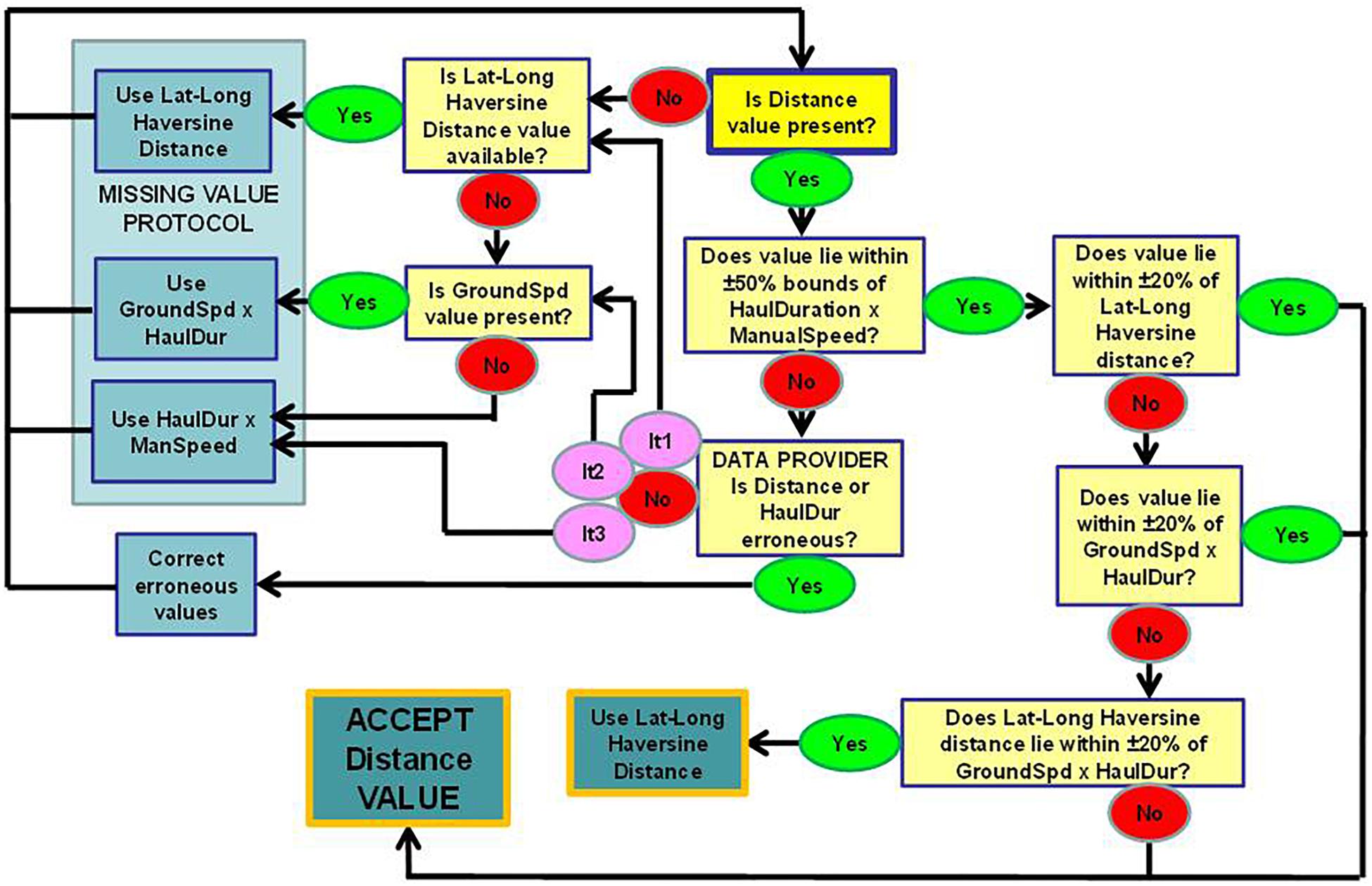
Figure 3. Flow chart illustrating the steps involved in assessing the validity of recorded Towed distance values and to estimate missing and replace incorrect data form Moriarty et al. (2017). Source Code – GITHUB https://github.com/MarineScotlandScience/MSFD-QA-GFSM-A-DP/blob/master/6_Haul_QA (Line 468–601).
Data UsaGe
In addition to using the data products described here to underpin assessments required to fulfill EBM needs, they can be used for any ecological research that requires estimates of numbers/abundance/biomass at length of given fish species (including many non-commercial species) at specified points in both space and time. There are now 15 fully QAQA data products available for such research (Table 1), with detailed R scripts and technical documents to allow complete reproducibility. The data products and documentation are available from https://data.marine.gov.scot and the code is accessible https://github.com/MarineScotlandScience/MSFD-QA-GFSM-A-DP/releases. It is the degree of consultation with NDPs, extent of review by experts involved in survey operations, data management, and assessment analysis (4 feedback loops, Figure 2), and the voluminous documentation describing the process (Greenstreet and Moriarty, 2017a,b; Moriarty et al., 2017), that separates the data products described here from those produced previously by individual scientists pursuing personal research programs.
Looking to the Future
Here we have identified one aspect of the increasingly diverse need for data to support ecosystem approaches to assess and manage our seas. The additional demands being made of groundfish survey data associated with implementation of legally mandated EBM such as the MSFD means that QAQA issues concerning data stored on shared databases like DATRAS must now be addressed. The first steps toward this, described here, were taken specifically to meet the immediate needs of the OSPAR Interim Assessment 2017.
The data quality issues highlighted here and detailed in Moriarty et al. (2017) are part of a wider discussion relating to survey design, optimization and managing the needs of end users. Data quality issues are inherent in historic time series, here we have identified and corrected many data issues within the European groundfish survey data. However, the discussion that has been initiated on data quality within our surveys will require big picture thinking and an international response. This conversation must be placed in the context of the wider discussion of survey optimization and modernisation in a changing environment. We must consider all the potential future changes, both mechanically (e.g., changes in fishing gears and practices) and environmentally (e.g., reducing impact of marine surveying on the environment).
The quality issues that emerged during this process related to many different aspects of the data collection process. The sampling information collected generally relates to where (e.g., location), when (e.g., date and time of day), gear configuration (e.g., type of ground-gear used), tow speed, tow duration and distance covered between the gear settling on the seabed on shooting and lifting off the seabed on hauling, and the effective width of gear to determine the area of seabed swept by the trawl. Accurate and consistent measurement and recording of all these parameters is critically important if the biological information collected is to be properly interpreted. For example, sample abundances are frequently reported as catch-per-hour, but our analyses suggest that tow speeds, and consequently the distance covered in a stipulated time (e.g., 30 min), can vary by as much as a factor of two. In such circumstance the same catch-per-hour values can give very different sample abundance estimates if instead these are reported as catch-per-km2 of seabed covered. As technology becomes more readily available to accurately measure these details it should be employed, and used consistently by all parties involved in ground fish survey operations.
The major issues found with the biological information collected on fisheries surveys were generally related to the non-commercial species. More training is required to facilitate accurate and consistent identification of clandestine species that might be encountered only infrequently. We must also consider how our surveys can help to inform on changes in our marine fish communities (e.g., shifting geographical ranges of species due to climate change). We will need to upskill our scientists to recognize fish species not previously reported. We may also need to consider adding modern, less destructive sampling techniques, such as eDNA, to our survey designs to better understand our changing fish communities. Strict guidelines relating to the sub-sampling of particularly large catches should be adhered to by all parties involved in collaborative surveys, with a single procedure for the recording of data obtained from such catches adopted by all involved. Ideally a single measurement unit would be used across all species sampled, but if this is not feasible, then the number of different measurement methods used should be kept to an absolute minimum, with clear guidelines as to the circumstances under which each particular method should be used.
Nineteen groundfish surveys were subjected to our QAQA protocol, each of these surveys follow their own survey protocols and individual survey designs (Moriarty et al., 2017). Because of their large geographic size no single MSFD sub-region in the Northeast Atlantic has been monitored by any single groundfish survey. It is important that we can appropriately integrate these surveys to assess fish community status and the status populations of individual species making up these communities. Where two surveys meet, it is imperative that paired tows are carried out on a regular basis so that we can make inference at scales that are relevant to the species. Moriarty et al.(in press), applies a generalized additive mixed modeling framework that allows scientist to combine all nineteen surveys to make inference on fish communities at the scale of the north east Atlantic. The Iberian coast region requires more support to better integrate these surveys, currently Spain only report commercially valuable species to DATRAS, this causes problems for scientists interested in understanding species and community distribution shifts at multiregional scales. Knowledge sharing and scientist exchange is key to increasing efficiency of our shared survey areas.
The work reported here has primarily been undertaken by a single national organization, albeit with huge cooperation from scientists, institutes, and institutions across Europe, but leaving this process in the hands of single organizations is not ideal. Firstly, resource implications, for example the manpower required, are not trivial and will need to be properly addressed moving forward. This is a huge responsibility; it is important that the job be done right, or at least, with full agreement and acceptance by all stakeholders involved. Such a task is best carried out as a formally organized co-operative collaborative enterprise. Assessments of the fish component of marine ecosystems will in the future continue to rely on the groundfish survey data collected by individual MS, and because these data are also needed to support stock assessments and implementation of the CFP, these data will continue to be uploaded and stored on DATRAS. ICES has both the expertise and the system in place, through its working groups supported by scientists from Europe and beyond, to ensure that the DATRAS can be made fully fit for purpose to meet both CFP and MSFD needs. To this end, ICES has already created a new DATRAS governance group. All that is left is to ensure that ICES has both the financial and scientific support from MS and the Regional Seas Conventions to ensure that DATRAS QAQA issues linked to MSFD implementation are fully understood and properly addressed. We propose that ICES DATRAS is the best existing solution to build on, and that the observations and lessons learned from the QAQA exercise described here should be adopted and incorporated through the means of a newly formed governance structure.
Data Availability
Publicly available datasets were analyzed in this study. This data can be found here: https://data.marine.gov.scot/dataset.
Author Contributions
MM carried out all data analysis and wrote the manuscript. JR and IdB provided technical support, guidance on analysis, and provided edits for the manuscript. SG was the principal researcher who lead the project and also provided major edits to the manuscript.
Funding
MM, SG, and JR were funded by the Scottish Government under Service Level Agreements ST02G (20451) and ST02H (20452) with Marine Scotland Science.
Conflict of Interest Statement
The authors declare that the research was conducted in the absence of any commercial or financial relationships that could be construed as a potential conflict of interest.
Acknowledgments
We are enormously grateful to colleagues at Marine Scotland Science, and institutes all around Europe, at various ICES and OSPAR working groups, and at the ICES Secretariat and Data Centre for their advice and support throughout this project. We would like to thank the editor and reviewers for their input.
References
Borja, A., Elliott, M., Snelgrove, P. V. R., Austen, M. C., Berg, T., Cochrane, S., et al. (2016). Bridging the gap between policy and science in assessing the health status of marine ecosystems. Front. Mar. Sci. 3:175. doi: 10.3389/fmars.2016.00175
Borja, A., Prins, T., Simboura, N., Andersen, J. H., Berg, T., Marques, J. C., et al. (2014). Tales from a thousand and one ways to integrate marine ecosystem components when assessing the environmental status. Front. Mar. Sci. 1:22. doi: 10.3389/fmars.2014.00022
Bundy, A., Shannon, L. J., Rochet, M.-J., Neira, S., Shin, Y.-J., Hill, L., et al. (2010). The good(ish), the bad, and the ugly: a tripartite classification of ecosystem trends. ICES J. Mar. Sci. 67, 745–768. doi: 10.1093/icesjms/fsp283
Dickey-Collas, M. (2014). Why the complex nature of integrated ecosystem assessments requires a flexible and adaptive approach. ICES J. Mar. Sci. 71, 1174–1182. doi: 10.1093/icesjms/fsu027
European Commission [EC] (2008). Directive 2008/56/EC of the European Parliament and of the Council of 17 June 2008 Establishing a Framework for Community Action in the Field of Marine Environment Policy (Marine Stategy Framework Directive). Official Journal of the European Union, 25.6.2008 L 164. Brussels: European Commission, 19–40.
European Commission [EC] (2010). Commission Decision of 1 September 2010 on Criteria and Methodological Standards on Good Environmental Status of Marine Waters (2010/477/EU). Official Journal of the European Union, 2.9.2010 L 232. Brussels: European Commission, 14–24.
European Commission [EC] (2013). Regulation (EU) No 1380/2013 of the European Parliament and of the Council of 11 December 2013 on the Common Fisheries Policy, Amending Council Regulations (EC) No 1954/2003 and (EC) No 1224/2009 and Repealing Council Regulations (EC) No 2371/2002 and (EC) No 639/2004 and Council Decision 2004/585/EC. Brussels:European Commission.
European Commission [EC] (2017). Commission Decision (EU) 2017/848 of 1 September 2010 Laying Down Criteria and Methodological Standards on Good Environmental Status of Marine Waters and Specifications and Standardised Methods for Monitoring and Assessment, and Repealing Decision 2010/477/EU. Official Journal of the European Union, 18.5.2017 L 125. Brussels: European Commission, 43–74.
Fung, T., Farnsworth, K. D., Reid, D. G., and Rossberg, A. G. (2012). Recent data suggest no further recovery in North Sea large fish indicator. ICES J. Mar. Sci. 69, 235–239. doi: 10.1093/icesjms/fsr206
Garrison, L. P., and Link, J. S. (2000). Fishing effects on spatial distribution and trophic guild structure of the fish community in the Georges Bank region. ICES J. Mar. Sci. 57, 723–730. doi: 10.1006/jmsc.2000.0713
Greenstreet, S. P. R., and Hall, S. J. (1996). Fishing and the ground-fish assemblage structure in the north-western North Sea: an analysis of long-term and spatial trends. J. Anim. Ecol. 65, 577–598. doi: 10.2307/5738
Greenstreet, S. P. R., and Moriarty, M. (2017a). Manual for version 3 of the groundfish survey monitoring and assessment data product. Scott. Mar. Freshw. Sci. 8:77. doi: 10.7489/1986-1
Greenstreet, S. P. R., and Moriarty, M. (2017b). OSPAR interim assessment 2017 fish indicator manual (Relating to version 2 of the groundfish survey monitoring and assessment data product). Scott. Mar. Freshw. Sci. 8:83. doi: 10.7489/1985-1
Greenstreet, S. P. R., and Rogers, S. I. (2000). “Effects of fishing on non-target fish species,” in Effects of Fishing on Non-Target Species and Habitats: Biological, Conservation and Socio-ECONOMIC Issues, eds M. J. Kaiser and B. de Groot (Oxford: Blackwell Science), 217–234.
Greenstreet, S. P. R., and Rogers, S. I. (2006). Indicators of the health of the fish community of the North Sea: identifying reference levels for an ecosystem approach to management. ICES J. Mar. Sci. 63, 573–593. doi: 10.1016/j.icesjms.2005.12.009
Greenstreet, S. P. R., Rogers, S. I., Rice, J. C., Piet, G. J., and Guirey, E. J. (2011). Development of the EcoQO for the North Sea fish community. ICES J. Mar. Sci. 68, 1–11. doi: 10.1093/icesjms/fsq156
Greenstreet, S. P. R., Fraser, H. M., Rogers, S. I., Trenkel, V. M., Simpson, S. D., and Pinnegar, J. K. (2012a). Redundancy in metrics describing the composition, structure, and functioning of the North Sea demersal fish community. ICES J. Mar. Sci. 69, 8–22. doi: 10.1093/icesjms/fsr188
Greenstreet, S. P. R., Rossberg, A. G., Fox, C. J., Le Quesne, W. J. F., Blasdale, T., Boulcott, P., et al. (2012b). Demersal fish biodiversity: species-level indicators and trends-based targets for the marine strategy framework directive. ICES J. Mar. Sci. 69, 1789–1801. doi: 10.1093/icesjms/fss148
Greenstreet, S. P. R., Spence, F. E., and McMillan, J. A. (1999). Fishing effects in northeast Atlantic shelf seas: patterns in fishing effort, diversity and community structure. V. Changes in structure of the North Sea groundfish assemblage between 1925 and 1996. Fish. Res. 40, 153–183. doi: 10.1016/S0165-7836(98)00210-0
Honey, K. T., Moxley, J. H., and Fujita, R. M. (2010). From rags to fishes: data-poor methods for fishery managers. Manag. Data Poor Fish. 1, 159–184.
International Council for Exploration of the Seas [ICES] (2009). Manual for the Offshore Beam Trawl Surveys, Revision 1.2, June 2009. Hamburg: Working Group on Beam Trawl Surveys.
International Council for Exploration of the Seas [ICES] (2012). Manual for the International Bottom Trawl Surveys. Toronto, ON: ICES.
International Council for Exploration of the Seas [ICES] (2013). Manual for the International Bottom Trawl Surveys In the North Eastern Atlantic Area Revision IV, 8-12 April 2013. Lisbon: ICES.
International Council for Exploration of the Seas [Ices]. (2015). Manual for the International Bottom Trawl Surveys, Revision VIII. Lorient: The International Bottom Trawl Working Group.
International Council for Exploration of the Seas [ICES] (2017). Database of Trawl Surveys (DATRAS). Copenhagen: ICES.
Jennings, S. (2004). The ecosystem approach to fishery management: a significant step towards sustainable use of the marine environment? Mar. Ecol. Prog. Ser. 274, 279–282.
Jennings, S. (2005). Indicators to support an ecosystem approach to fisheries. Fish Fish. 6, 212–232. doi: 10.1111/j.1467-2979.2005.00189.x
Jennings, S., Greenstreet, S. P. R., and Reynolds, J. (1999). Structural change in an exploited fish community: a consequence of differential fishing effects on species with contrasting life histories. J. Anim. Ecol. 68, 617–627. doi: 10.1046/j.1365-2656.1999.00312.x
Jennings, S., and Rice, J. (2011). Towards an ecosystem approach to fisheries in Europe: a perspective on existing progress and future directions. Fish Fish. 12, 125–137. doi: 10.1111/j.1467-2979.2011.00409.x
Link, J. S., and Browman, H. I. (2014). Integrating what? Levels of marine ecosystem-based assessment and management. ICES J. Mar. Sci. 71, 1170–1173. doi: 10.1098/rspb.2010.0353
Moriarty, M., Greenstreet, S. P. R., and Rasmussen, J. (2017). Derivation of groundfish survey monitoring and assessment data products for the Northeast Atlantic. Scott. Mar. Freshw. Sci. 8:240. doi: 10.7489/1984-1
Moriarty, M., Pedreschi, D., Smeltz, T. S., Sethi, S. A., Harris, B. P., McGonigle, C., et al. (in press). Combining Fisheries Surveys to Inform Marine Species Distribution Modelling Submitted to ICES JMS.
Needle, C. L. (2015). Using self-testing to validate the SURBAR survey-based assessment model. Fish. Res. 171, 78–86. doi: 10.1016/j.fishres.2015.03.001
Shin, Y.-J., Rochet, M.-J., Jennings, S., Field, J. G., and Gislason, H. (2005). Using size-based indicators to evaluate the ecosystem effects of fishing. ICES J. Mar. Sci. 62, 384–396. doi: 10.1016/j.icesjms.2005.01.004
Shin, Y.-J., and Shannon, L. J. (2010). Using indicators for evaluating, comparing and communicating the ecological status of exploited marine ecosystems. 1. The IndiSeas project. ICES J. Mar. Sci. 67, 686–691. doi: 10.1093/icesjms/fsp273
Shin, Y.-J., Bundy, A., Shannon, L. J., Simier, M., Coll, M., Fulton, E. A., et al. (2010a). Can simple be useful and reliable? Using ecological indicators to represent and compare the states of marine ecosystems. ICES J. Mar. Sci. 67, 717–731. doi: 10.1093/icesjms/fsp287
Shin, Y.-J., Shannon, L. J., Bundy, A., Coll, M., Aydin, K., Bez, N., et al. (2010b). Using indicators for evaluating, comparing, and communicating the ecological status of exploited marine ecosystems. 2. Setting the scene. ICES J. Mar. Sci. 67, 692–716. doi: 10.1093/icesjms/fsp294
Tam, J. C., Link, J. S., Rossberg, A. G., Rogers, S. I., Levin, P. S., Rochet, M.-J., et al. (2017). Towards ecosystem-based management: identifying operational food-web indicators for marine ecosystems. ICES J. Mar. Sci. 74, 2040–2052. doi: 10.1093/icesjms/fsw230
ter Hofstede, R., and Daan, N. (2006). “Quality check surveys: DATRAS North Sea IBTS,” in Report of the International Bottom Trawl survey Working Group (IBTSWG) 27-31 March 2006. Report. ICES CM 2006/RCM:03, Ref ACFM. Lysekil: ICES.
ter Hofstede, R., and Daan, N. (2008). A Proposal for a Consistent Use of the North Sea IBTS Data. ICES CM 2008/R:25. Available at: www.ices.dk/sites/pub/CM%20Doccuments/CM-2008/R/R2508.pdf
ter Hofstede, R., Hiddink, J. G., and Rijnsdorp, A. D. (2010). Regional warming changes the species richness of marine fish in the eastern North Atlantic Ocean. Mar. Ecol. Prog. Ser. 414, 1–9. doi: 10.3354/meps08753
Keywords: data quality assurance, data quality audit, Marine Strategy Framework Directive, Common Fisheries Policy, data management, ecosystem-based management
Citation: Moriarty M, Greenstreet SPR, Rasmussen J and de Boois I (2019) Assessing the State of Demersal Fish to Address Formal Ecosystem Based Management Needs: Making Fisheries Independent Trawl Survey Data ‘Fit for Purpose’. Front. Mar. Sci. 6:162. doi: 10.3389/fmars.2019.00162
Received: 05 December 2018; Accepted: 14 March 2019;
Published: 02 April 2019.
Edited by:
Michael Arthur St. John, Technical University of Denmark, DenmarkReviewed by:
Laura Uusitalo, Finnish Environment Institute (SYKE), FinlandErika M. D. Porporato, Università Ca’ Foscari, Italy
Copyright © 2019 Moriarty, Greenstreet, Rasmussen and de Boois. This is an open-access article distributed under the terms of the Creative Commons Attribution License (CC BY). The use, distribution or reproduction in other forums is permitted, provided the original author(s) and the copyright owner(s) are credited and that the original publication in this journal is cited, in accordance with accepted academic practice. No use, distribution or reproduction is permitted which does not comply with these terms.
*Correspondence: Meadhbh Moriarty, bW9yaWFydHktbTNAdWxzdGVyLmFjLnVr